File:A New map of Poland and the Grand Duchy of Lithuania, shewing their dismemberments and divisions between Austria, Russia and Prussia in 1772, 1793 and 1795. From the latest authorities. By John Cary (IA bp 33312).pdf

Original file (3,756 × 3,050 pixels, file size: 3.86 MB, MIME type: application/pdf)
Captions
Captions
Summary[edit]
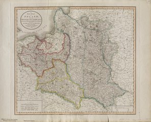
| A New map of Poland and the Grand Duchy of Lithuania, shewing their dismemberments and divisions between Austria, Russia and Prussia in 1772, 1793 and 1795. From the latest authorities. By John Cary, engraver, 1799.
( |
|
|---|---|
| Title |
A New map of Poland and the Grand Duchy of Lithuania, shewing their dismemberments and divisions between Austria, Russia and Prussia in 1772, 1793 and 1795. From the latest authorities. By John Cary, engraver, 1799. |
| Publisher |
John Cary, London |
| Description |
Hand col. outlines engraved, 43.5 x 49 cm. on sheet 52 x 65 cm.;Probable source: "Cary's New Universal Atlas, containing distinct map from all the principal states and kingdoms throughout the world ..." 1808.;From the Whistance-Smith Collection.;Relief & forests shown pictorially.;Detailed place names, geographic features and administrative boundaries.;[Plate] '35' affixed in upper right. Subjects: Poland--Political geography |
| Language | English |
| Publication date | Aug 1, 1799 |
| Current location |
IA Collections: wcw_gale; wcw; university_of_alberta_libraries; toronto |
| Accession number |
bp_33312 |
| Notes | Scale: Ca. 1:2,660,000 |
| Source | |
Licensing[edit]
|
This work is in the public domain in its country of origin and other countries and areas where the copyright term is the author's life plus 70 years or fewer.
| |
| This file has been identified as being free of known restrictions under copyright law, including all related and neighboring rights. | |
File history
Click on a date/time to view the file as it appeared at that time.
| Date/Time | Thumbnail | Dimensions | User | Comment | |
|---|---|---|---|---|---|
| current | 13:09, 27 August 2021 |  | 3,756 × 3,050 (3.86 MB) | Fæ (talk | contribs) | IA Query "collection:(wcw) date:[1000 TO 1899]" bp_33312 Category:William C. Wonders Map Collection (COM:IA books#query) (1799 #320) |
You cannot overwrite this file.
File usage on Commons
The following page uses this file: