The maps featured in this section do not represent the entire catalogue presented in China in European Maps. Rather, the brief sampling offered here follows Chang’s own recommendations in the preface to her book. These maps are not only the most influential in making China, but they also exhibit most clearly the gradual process of cultural exchange between East and West, as observed by Chang.
———
Ortelius Chinae
– 1584 –
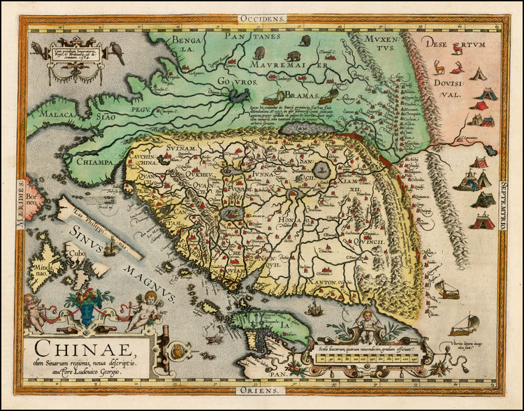
The “Ortelius Chinae” was created by renowned cartographer Abraham Ortelius in 1584. It is the first known European map of China, i.e. the first non-native representation of the region. Moreover, this map represents the first usage of the term “China” to refer to the country between India and Japan. In fact the “Ortelius Chinae” was so popular in its time that it was used as Europe’s official map of China for two decades after its completion.
Unlike present day maps of China, the North is oriented to the right side of the page. In so doing, the West is placed above the East, effectively mirroring sixteenth century colonialist, and ethnocentric ideals; namely, that the Occident is superior to the Orient. The dominance of European influence is evident in the decorations on the map as well. Instead of incorporating Chinese cultural figures, Ortelius opts to adorn his map with cherubs, an obvious inheritance from the European Christian tradition.
As the first European-constructed map of China, there are several deficiencies in Ortelius’ map. Of the twenty-three provinces in China, Ortelius only names fifteen. Also, in comparison to the illustration of India, China is less detailed. India is not only topographically identified, but symbolically depicted as well. Its mountains and riverways are accompanied by elephants and caravans. Meanwhile, China is a mere plot of land, with some mountains, a few rivers, and a great wall on its northwestern edge.
Hondius Model
– 1606 –
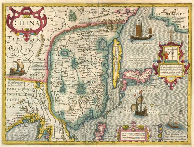
In 1606, Dutch cartographer Jocodus Hondius reconstructs Ortelius’ map of China. While he draws heavily from the “Ortelius Chinae,” he introduces some new conventions to the cartography of China, and resurrects Gerardus Mercator’s projection map style, which then had fallen out of favour.
Ortellius’ influence is perhaps most apparent in the lack of detail of the Chinese region. Akin to the “Ortelius Chinae,” China’s features are limited to topographical characteristics, such as maritime and geological formations. The number of provinces named on this map are also the same as in Ortellius’. It seems that the amount of information about China has not been drastically altered over two decades.
What did change however are the aesthetic features utilized in constructing the map of China. For one, there are no cherubs flying over the title “China.” Instead, we see an attempt to replicate Oriental architectural designs. The frame surrounding “China” resembles the shape of many Taoist and Buddhist temple roofs across East Asia.
Howbeit, the Hondius model is not entirely free from European ideals. There may be no cherubs fluttering about in Hondius’ China, but there remains echoes of Christianity, made very audible by the crucifix portrayed on the right hand-side. Furthermore, Hondius’ map includes illustrations of European ships sailing across the Pacific Ocean (Chinensis Oceanus), which can be taken as literal markers of Western presence in the Orient. To the seventeenth century European individual, China then was undoubtedly a part of the known world, but one that has yet to be fully explored.
The Map of China
– 1625 –
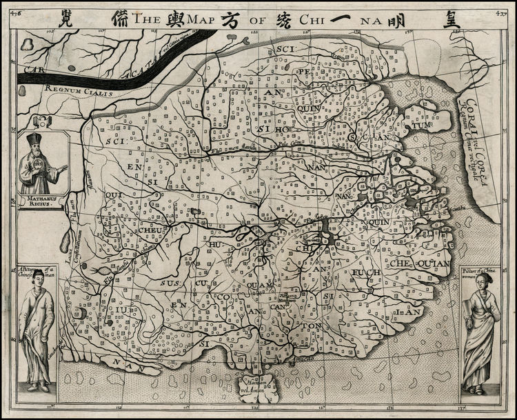
Samuel Purchas’ “The Map of China” is the first map of China printed in the English language. Interestingly, it is also the first European map of China that uses an actual Chinese source. Whereas both Ortelius and Hondius relied on travel accounts from various Dutch or Flemish explorers, Purchas draws from “a map of China in the Chinnish language,” acquired by East India Company captain John Saris.
The differences in aesthetics between Purchas’, and Ortelius’ and Hondius’ respective maps can be seen as an immediate result of the so-called “Chinnish” source. Unlike Ortelius and Hondius, Purchas takes time to make his map appear more Chinese than European. He foregoes colourful embellishments, opting instead for a simple black and white depiction of the region. More so, Purchas zooms in on China, leaving India and Japan this time at the periphery. Purchas’ focus then is not to present China to the European world, but just to show China.
In addition, the level of detail of Purchas’ map is a far leap from Ortelius’ and Hondius’ strictly topographical rendering of the region. Not only does “The Map of China” replicate the complexity of the Chinese river and village systems, it also showcases depictions of the people themselves; Ortelius’ cherubs and Hondius’ crucifix are replaced by the “Portrait of a Chinese Man,” and the “Portrait of a Chinese Woman.”
Despite its incredible detail, and cultural sensitivity, Purchas’ map did not become as influential as either the “Ortellius Chinae” or Hondius model. However, it did indicate the desire of the West to understand the East, and pave the path perhaps to the eventual recognition of China as a culturally rich and distinct region. That is, Purchas put China on the map as a wholly unique place, nestled between two equally unique Eastern countries.
———
Although the maps presented here are but minute pieces pulled from Chang’s more comprehensive catalogue, they have hopefully reflected the continuous evolution of the European conceptualization of China. From these maps, it is clear that the cultural exchange between the East and West is not non-reciprocal. While European cartographers initially attempted to Westernize the East through religious iconography and design, the vibrancy of the Chinese culture eventually broke through the Western science of cartography. Purchas is but one example of a European cartographer, who was enticed by the mystery of the Orient. More importantly, the maps studied here attest to the verbosity of non-lexical objects. That is, maps have the capacity to make statements as effectively as words do. In fact,. at times, maps are more fluent because they can outline the changing of the world in a mere fifty pages.
