One of the differences between Londoners born in London and those who come to it later in life like me is the way we “learn” London. My wife was born and raised in Chelsea. She got to know the area round her home as a child and as she grew up her world grew logically. I first came to London on holiday, to stay with relatives and see the sights.
“A foreign student said to me / Is it really true? / There are elephants and lions too / At Piccadilly Circus?”
Then I was a student myself. My London grew around the first travel aid I had, the tube map, so isolated pockets of familiar territory gradually expanded and (usually) joined up. These pockets are also chronological layers so occasionally a piece of your deep history comes up against a new place you’ve come to know. I pass through the area near South Kensington Station several times a week but it was also one of the first parts of London I visited regularly. It’s near the museums of course and there’s a small district of shops clustered around the station on the four or five streets which converge on it. We’ve looked at one of those streets, Pelham Street, before in the photographs of John Rogers. John’s task was to take pictures of the streets and the buildings in them. The inhabitants of the streets were incidental. But in this week’s collection the people take over that small territory and become the main subject of the images.

There’s a good selection of 1970 people waiting for the bus westwards. Three examples of the middle aged woman in a headscarf, still common back then. Two young women with fashionable carrier bags , one in an early maxi-coat, a hefty teenage boy out of uniform but not yet sure what he is supposed to wear, and walking past the queue a dude whose hair is getting good in the back wearing a trendy coat. Lots of life here, and an advert for Red Bus Rovers, a boon for anyone who wanted to kill time by going to, say Homerton, at the end of the line. This is the Thurloe Street entrance to the station.

To the right, a tobacconist (with room for toys and games) a fruiterer, and a confectioner. Note the people crossing the road , including the mother with two sons.

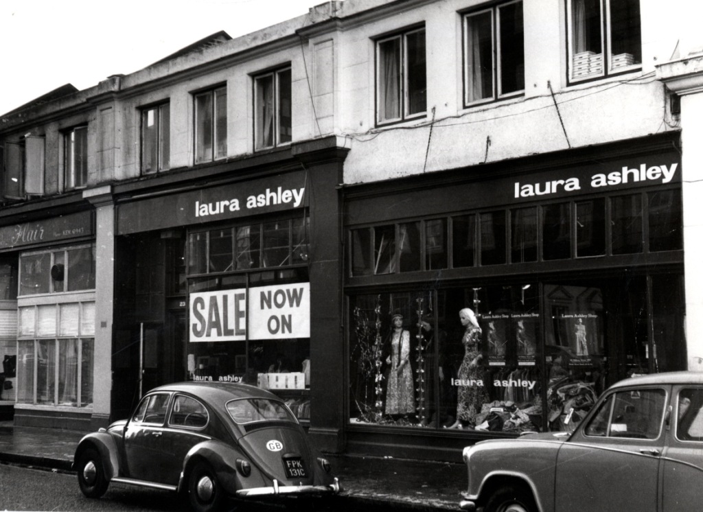
There is a ladies outfitters, Merle, occupying two shop fronts (business rates must have been low, but of course for clothes in 1970 it was either shops or mail order catalogues). According to Kelly’s directory the next unit is Dino’s Restaurant which you can see in this post about Pelham Street. Below, we’re looking east along Thurloe Street.

A father and daughter are crossing the road, looking out for traffic. They might have appreciated the modern Thurloe Street which is now largely pedestrianised.

A young woman has crossed safely and the bus has gone. The woman at the stop was in the first picture I think. There were two stops, one I think for 14s and one for 74s. The 49 also stopped there, and the 45A started and terminated just round the corner in Exhibition Road.
Then as now, many of the businesses in this area were food outlets of one kind or another. Here is the South Kensington Restaurant (or the SKR).

A quite extensive establishment. Note the road marking for Fulham.
Her’s the other bus stop with an expectant family duo.

Along with a TV and electrical store, and another Cafe.
Next to it the Medici Society shop, for prints and cards, the only one that remains today.

And a Wimpy Bar! The rather half-hearted British attempt at a hamburger chain which we had before McDonalds. Remember the plastic covered menus, and the waitress service (the British didn’t queue up in a cafe back then)? The burgers were okay as I recall but then we didn’t know any better.

Pultney, for books and prints, with a smart father and son passing by, and another restaurant, Daquise, on the corner. You can see some paving in the middle of the road which kept the streams of traffic apart in the comparatively narrow street which had to take, cars, pedestrians and buses turning off Brompton Road.
I’ve enlarged a detail from the next image to show you the most fashionable woman in this group of pictures.

The lady on the left of the duo, wearing a very 1970 cape, a new trend at the time. As always with these pictures you can enlarge them enough to get a sense of the person but not much more.
Opposite the shops Thurloe Street meets the tail end of Exhibition Road. That island can be seen more clearly.

You can also see some metal structures on the island. These are air shafts for the foot tunnel which leads from the ticket hall of the station under the road to the museums in Exhibition Road.
The bus is actually a 207a (a former trolley bus route) which came all the way from Hayes, sometimes terminating here, sometimes going onto Chelsea to where the 31s (now 328s) finished. You can just about see a man in a London Transport white coat standing next to the bus.
Almost occluded by the bus is another restaurant, Chompers, which I note partly because it’s a characteristically 1970s name but also because I ate there once with my friends Carl and Trixie. I’ve already recorded on another occasion that Carl sadly died in 1999. Pictures of South Kensington remind me of him because he went to nearby Imperial College and lived in student accommodation in Cranley Gardens, very close to where I live now. So those two small areas are among the deepest layers of my personal chronological map of London.
Beyond the air shafts are the offices of the Kensington and Chelsea Post newspapers.

This is the opposite corner of Thur;oe / Exhibition Road.

(With a nice Jaguar / Daimler.)

That single story outcrop from the two terraces runs the length of the block. Here are some more air shafts, and a bookseller, with a purposeful dude striding across the street. There used to be a shop on that side of the road that sold all sorts of paper crafts and art materials. There are no pictures of that in this set. But it’s in a different chronological layer of my London history. You can’t visit them all at once.
Postscript
When I was first in London I wanted to go to Blake Hall, a station I saw on the Tube map near the end of the Central Line. It sounded interesting. But I never did, and you can’t now, although I believe the station buildings still exist, on the way to Ongar.
The lyric at the start comes from a song on the Jethro Tull album Aqualung, which I might have already disowned before I came London. But the words stuck in my mind.
I should also apologise to anyone called Blanka Azdajic, a name I have used a couple of time in my Halloween stories. I consulted by friend Nina when I wanted an authentic sounding Serbo-Croatian name. Too authentic it seems. So let me just say my Blanka is a fictional character and her place of work is not located in this universe. I was a bit short of inspiration this year. I had thought of sending Blanka on an urban exploration expedition to some desolate industrial site but I couldn’t think what might have happened there so I left it thinking I wouldn’t bother this year. Then I saw some pictures of the old market hall in Chester and I remembered buying magazines and comics there. I still own some dilapidated copies of Castle of Frankenstein and other magazines including one whose cover is devoted to a film called the Brain that wouldn’t die. (You can find it on YouTube. ) In the information poor early 1970s the monster magazines were often the only way horror film fans could find out about particular films. Castle of Frankenstein was one of the more literate of the genre. The reference to Edgar Rice Burroughs’ Frankenstein on the cover last week was to an obscure book by the creator of Tarzan and John Carter called the Monster Men, a sort of cross between Frankenstein and the Island of Dr Moreau. I had (and presumably still do have somewhere) a tiny Ace edition.