Category Archives: Fire Ecology & Management

Facilitated natural regeneration in the ‘Middle clearing (Setaria plots)’ of Minyumai Indigenous Protected Area, The Gap NSW

Minyumai Rangers

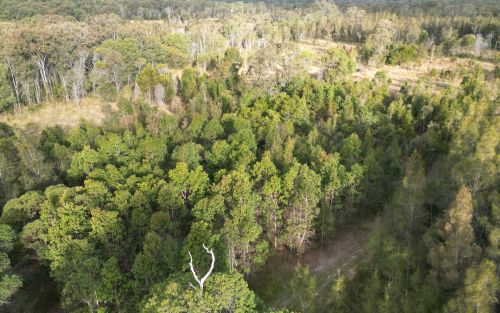
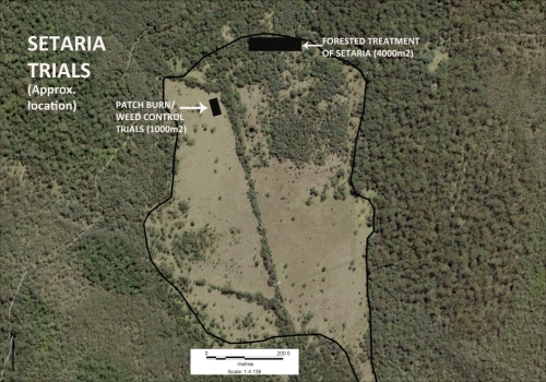
Figure 1. Aerial view of the Setaria-dominated clearing at Minyuma IPA prior to restoration work . The trial area arrowed is the location of the preliminary trial of herbiciding plus fire followed by regular spot spraying of weed regrowth. The project was then expanded to much of clearing to the left of the artificial drain running through the centre of the site (Photo Minyuma IPA)

Introduction. ‘Minyumai’ is an approx. 2000ha property owned by Minyumai Landholding Aboriginal Corporation (MLHAC) and managed by the MLAC board and the Minyumai Rangers. The property is located on the far north coast of NSW, adjacent to Bundjalung National Park and Tabbimoble Nature Reserve and was dedicated as an Indigenous Protected Area (IPA) in 2011. 

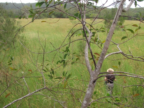
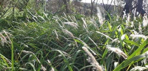
The property is largely comprised of native ecosystems, including five Endangered Ecological Communities (EECs), however it has a history of grazing in largely three sizeable clearings.  The largest and most degraded of these clearings (the ‘middle clearing’) (Figs. 1 and 2) became known to the Rangers as the ‘Setaria plots’ as it was almost completely devoid of trees, was dominated by the introduced pasture grass Setaria (Setaria sphacelata) and was subsequently divided into multiple plots for treatment and monitoring.

Figure 2. Closer view of the density and cover of Setaria at the site prior to treatment. (Photo Minyuma IPA)

The purpose of the work in the Setaria plots is to convert the vegetation from weed dominance to dominance by native species of the site’s prior ‘Swamp sclerophyll forest on coastal floodplains’ EEC. The project started in 2014 and is an ongoing part of the Ranger’s regular works program. 

Works undertaken. After a successful trial sponsored by Firesticks in an adjacent area, a facilitated natural regeneration approach was adopted in the Setaria plots, supplemented by some tree planting. While there were little or no above-ground natives evident among the mature Setaria at the start of the project (Fig 2), the Firesticks trial showed that the use of fire followed by precision weed spraying would result in at least some regeneration of native ground covers from the soil seed bank.

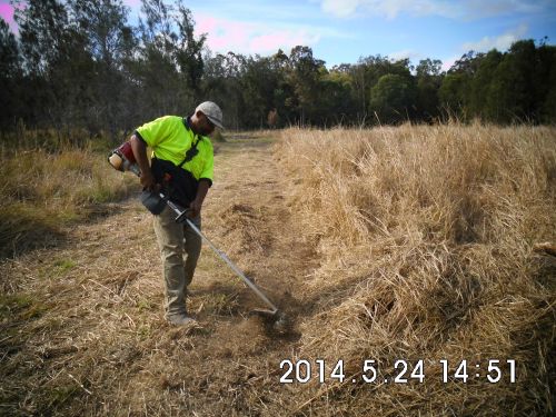
Figure 3. Firebreaks were installed at the site prior to spraying and burning and remain maintained to allow for ongoing use of fire during over time should it prove beneficial. (Photo Minyuma IPA)
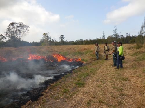
Figure 4. Minyumai Rangers and visitors from a neighbouring IPA running a burn on the site. (Photo Minyuma IPA)

The plot-by-plot approach subsequently adopted involved creating firebreaks, overspraying the mature setaria with 1% glyphosate and subsequent burning of the dried weed biomass (Figs 3 and 4).  Subsequent follow-up spot-spraying was then systematically and regularly carried out.

Monitoring.  The project offered an opportunity to separate and compare burn and spray treatments with spray-only treatments – i.e.  all plots (except untreated controls) were subjected to systematic weed management but some were additionally burnt.  Species counts and cover was measured at 2 years of age and again at 4 years of age – with the ground stratum monitored using 15 quadrats (7 burn+spray, 6 spray only and 3 controls) and woody cover monitored using 18  (20m) transects (line intercepts).

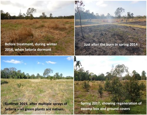
Figure 5. Photopoint monitoring showing changes at the site over a 3 year period showing treatments and gradual regeneration of natives. (Photos Minyuma IPA)

Results to date.  While the initial follow up treatments revealed extensive weed, this rapidly transitioned to native dominance over time (Fig 5) and with fairly rigorous herbicide treatment of all weed by the Rangers.  The site developed high levels of cover within 18 months. A total of  37 native species were recorded over the four years (including 5 trees, 2 shrubs,  1 vine, 18 forbs, 7 sedges and 4 grasses) .  A total of 26 weed species (1 shrub, 14 forbs, 2 sedges and 9 grasses) occurred and while weed cover reduced over time ) most species of weed remained present in the system.  

The quadrat data showed that the fire plus spot-spraying treatment resulted in improved native cover in the ground stratum (scoring an average of 3.38 on a 5 level cover scale)  compared to spot-spraying alone (scoring an average of 2.17 on the 5-level cover scale) with the controls remaining in the lowest cover level.

Transect monitoring of woody species cover over time showed a significant increase in tree cover after both fire plus spray (n=5)  and spray alone (n=9) treatments compared to the untreated controls (n=4) but there was no significant difference between the burn plus spray and spray only  treatments, which is understandable as none of the tree species form soil seed banks.

Figure 6.  Drone photo of the same quadrats from the air in August 2023, nine years after the work commenced. The dense green tree growth in the middle of the photo is all regrowth on the treated plots. Between this area and the intact Paperbark forest in the further distance there is a band of untreated land still dominated by Setaria and without native colonisation. (Note the Eucalypt circled is the same Eucalypt in the right hand background of the photos in Figure 5.)   (Photo G. Little)

Changes over time. The sedges, which were initially abundant in the understorey,  became less abundant over the two readings. Native grasses were initially far less common but increased over time, and 10 years on are still far less prevalent than sedges, which makes sense considering the wetland nature of the site.

Some  forbs, such as Buttercups (Ranunculus spp.), Gotu Kola (Centella asiatica), Pennyworts (Hydryocotyle spp.), Kidney Weed (Dichondra repens) and Native St Johns Wort (Hypericum perforatum) became frequent or abundant and remained so over the monitoring period. while other forbs such as Grass Lily (Murdannia graminea), Ludwigia (Ludwigia and Native Bluebell (Wahlenbergia sp.) remained uncommon or even rare.

Over the 10 years since the project began, the tree species Swamp Box (Lophosptemon suaveolens), Swamp Oak (Casuarina glauca) and Broad-leaved Paperbark (Melaleuca quinquinervia) have all become markedly more abundant over time through colonisation from the surrounding forest (Fig. 6) – with natural regeneration far outweighing any tree planting efforts made at the start of the project.  Forest Red Gum (Eucalyptus tereticornis) did not however increase from the remnant tree on site nor did planted seedlings of this species survive.   

Lessons learned and future directions.  When comparing the treated areas with untreated areas it is clear that the native tree colonisaton is confined to the treated areas. Although the treated areas developed high native herbaceous cover it is likely that the open niches created by the weed control and fire allowed colonisation by trees, while the dense Setaria cover prevented regrowth. 

A major challenge has been the presence of wild cattle on the property that have proved resistant to capture. This required electric fencing of the site for some years to avoid damage to plantings, although natural regeneration has now overtaken the plantings.

Critical to success was rigorous follow up prior to the weed reseeding.  Complete avoidance of reseeding was not always possible due to funding limitations or personnel changes. This has resulted in some reinvasion of Setaria in some of the plots, although the Rangers continue to manage the site well. 

As the mown firebreaks are still in place, there is potential for cool fire to be reintroduced into the site (followed by further weed control) should this be considered ecologically beneficial.  The site may also benefit from a project (being conducted in collaboration with Nature Glenelg Trust) to fill in the artificial drain visible in Fig 1.

Stakeholders and Funding bodies.  We acknowledge the valuable contributions of all the Minyumai IPA Rangers, particularly the early leadership of Minyumai Rangers, Daniel Gomes, Justin Gomes and Belinda Gomes. The Commonwealth Government’s IPA program funded the delivery of biodiversity management services by MLHAC, and funding and advice for the fire trials was provided by the NSW Nature Conservation Council’s  Firesticks initiative, with advice from Oliver Costello and Richard Brittingham. Tein McDonald advised on techniques and monitoring and Andrew Johnston provided training for the Minyumai Rangers in the first years of the project.

Contact: Mary Wilson, Minyumai Land Holding Aboriginal Corporation. Email: <admin@minyumai.org.au>

Post-fire assisted regeneration at Rutidosis Ridge, Scottsdale Reserve, Bredbo NSW


Figure 1. Undamaged grassy woodland reference site occurring at high elevation at Scottsdale (Photo: Brett Howland)

Introduction. Scottsdale Reserve is a 1,328-hectare private conservation reserve, near Bredbo NSW, owned and managed by Bush Heritage Australia. For over 100 years prior to purchase in 2006 the property was utilised for grazing and cropping. While most of the higher elevation areas of the property remained intact and offered the basis for improving landscape connectivity for wildlife, the agricultural land use had resulted in conversion of the flats and lower slopes of the property to largely exotic pasture species and accompanying weed.

This case study focuses on one approx 10 ha Apple Box (Eucalyptus bridgesiana) / Snow Gum, (Eucalyptus pauciflora) grassy woodland ridge within the property – named ‘Rutidosis Ridge’ because it is the location of a small population of the Endangered plant species Button Wrinklewort (Rutidosis leptorhynchoides). Set-grazing by sheep as well as some cropping had left the site nearly wholly dominated by the landscape-transforming exotic pasture grasses African Love Grass (Eragrostis curvula) and Serrated Tussock (Nasella tricotoma). Some scattered copses of eucalypts and some herbaceous natives remained, however, suggesting that the site might have some native regeneration potential, but the number and abundance of natives on the site appeared very low and the site was very dissimilar to a nearby healthy reference site (Fig. 1).

Works undertaken. Around a decade after land purchase and the discontinuation of grazing and cropping, Rutidosis Ridge was aerially sprayed during winter with flupropinate herbicide at a low dilution (1L / ha) known to be effective on some strains of African Love Grass and Serrated Tussock without killing native grasses and forbs. While the African Love Grass and Serrated Tussock had died by the following spring as a result of this soil-active herbicide, no substantial native regeneration was observed due to the persistence of the thick thatch of dead African Love Grass (Fig 2).

  • Figure 2.  Typical site showing sprayed African Love Grass thatch even many years after aerial spraying. (Photo T. McDonald )
  • Figure 3.  Intense wildfire that passed through Bredbo, NSW in early February. (Photo” New York Times)

An intense wildfire passed through the property on 2nd February 2020 (Fig. 3). This largely consumed the thatch, exposing stony topsoils and providing opportunities for regeneration of both natives and weeds that were stored in the soil seed bank.  Anticipating the need for post-fire spot-spray follow-up after the fire to avoid any native regeneration being overwhelmed by weed, Bush Heritage Australia (BHA) collaborated on a program of regular selective treatment of weed with the restoration organisation the Australian Association of Bush Regenerators (AABR). Personnel involved both contractors and volunteers skilled in recognising natives and weeds at seedling stage capable of spot-spraying with negligible off-target damage (Fig 4).  

Because the fire had removed African Love Grass thatch and cued germination of natives and weeds, the aim was to treat all weed prior to its seeding.  This allowed the managers to (a) take advantage of the fire’s flushing out the weed soil seed bank and avoid its further recharge and (b) retain maximum open spaces for further natives to emerge and colonise. 

During the year after the fire (March 2020-April 2021), the ~10ha site had been subjected to approx. 600 person hours of spot spraying, mainly undertaken by experienced bush regenerators. This commenced in March 2000 and continued at least fortnightly during the growing season.

Figure 4. Location of comprehensively spot-sprayed areas and target-weeded areas at Rutidosis Ridge. An opportunity exists to compare differences in richness and cover of natives and weed between the two treatments, ensuring comparisons are confined to within-comparable condition classes.

What we found by 1 year of treatments.  Post-fire observations in  March 2020 revealed Snow Gum resprouting from lignotubers and roots and Apple Box and Candlebark (Eucalyptus rubida) resprouting epicormically.  A wide suite of native grasses and forbs were starting to resprout or germinate alongside diverse herbaceous weeds. Within the first 12 months of regular spot-spraying, the cover and seed production of approx. 30 weed species was very substantially reduced.  Combined with fairly evenly distributed rainfall in the follow 12 months this reduction in weed allowed ongoing increases in native species cover and diversity per unit area, with seed production likely by most native species.  There was negligible off-target damage from the spray treatments. In December 2020 over 50 native herbaceous and sub-shrub species (including at least 11 Asteraceae, 9 Poaceae, 4 Fabaceae and 2 Liliaceae) were recorded within the work zones, with cover of natives very high in the higher condition zones, but plentiful bare ground remaining in the lower condition zones (Fig. 5).  

Figure 5.  Top:  Directly after wildfire showing black stubs of African Love Grass; Middle: Volunteers spot-spraying during the growing season, and Bottom: same site after 12 months but when native grasses were curing off after seeding. (Photos T. McDonald)

Predominant weed species included recovery African Love Grass, Viper’s Bugloss (Echium vulgare), St John’s Wort (Hypericum perforatum), Yellow Catsear (Hypochoeris radicata), Common Plantain (Plantago major), a range of thistles and around 20 other weed species.

Predominant natives included speargrasses (Austrostipa spp.), Redleg Grass (Bothriochloa macrantha), Kangaroo Grass (Themeda triandra), Native Panic (Panicum effusum), Common Raspwort (Gonocarpus teucrioides), Bindweed (Convolvulus erubescens), bluebells (Wahlenbergia spp.), Common Everlasting (Chrysocephalum apiculatum), fuzzweeds (Vitadennia spp.), Bear’s Ear (Cymbonotus lawsonianus), Creamy Candles (Stackhousia monogyna), Yellow Pimelea (Pimelea curviflora subsp. fusiformis) and Native St John’s Wort (Hypericum gramineum).  Species of higher conservation interest that regenerated included Blue Devil (Eryngium ovinum) and Threatened species that regenerated included Silky Swainson’s Pea (Swainsona sericea) and Button Wrinklewort. (Some of these species are pictured in Fig. 6).

Figure 6. Some of the forbs that flowered on Rutidosis Ridge during the growing season – including the Endangered Button Wrinklework (centre) and Vulnerable Silky Swainson’s Pea.(bottom left). (Photos various.)

Gradient of condition improving over time. As expected, the sites showed a gradient of condition (Fig. 7), with highest natural regeneration capacity retained in the tree clusters and stony crest, perhaps due to these less likely to be less favoured by sheep. (The tree clusters appear not to have been used as sheep camps). By March 2020, 1 year after work commenced, all sites were on a trajectory to move to the next higher condition class, assuming successful Winter 2021 aerial spray re-treatment of African Love Grass.  (Note that, while the pre-fire flupropinate treatment would normally have a residual effect for a few years and thus preventing germnation of this species, massive germination did occur of African Love Grass in many areas, which we speculate was either due to suitable post-fire germination conditions being delayed by the presence of dead grass thatch or to a possible denaturing of the chemical by the fire.)  

Figure 7. Condition classes in the Rutidosis Zones A-E revealed during the first few months of treatment. By the end of the growing season and after regular follow up spot-spraying it was clear that all zones comprehensively treated were improving in their native: weed cover ratio except for an increasing cover of African Love Grass, the treatment of which was deferred until a second aerial spray scheduled for winter 2021. (Map: T. McDonald)

Acknowledgements: This project would not have been possible without the help of BHA and AABR volunteers.

Contact: Tein McDonald and Phil Palmer, Scottsdale Tel: +61 (0) 447 860 613; Email: <teinm@ozemail.com.au and phil.palmer@bushheritage.org.au


Crowdy Bay National Park, NSW – Assisted regeneration of a littoral rainforest patch post 2019-20 summer wildfire

Figure 1. Volunteers at the initial working bee in the burnt littoral rainforest.

Introduction. Crowdy Bay National Park is located on the NSW Mid-north coast and comprises coastal landscapes, some of which have were sand mined prior to the area’s acquisition for conservation in the 1970s. Littoral rainforest remnant and regrowth patches occur within the Park and are listed at State level and as Endangered Ecological Community and at national level as a Threatened Ecological Community. The rainforest community type forms in the dune swales, protected by Coast Banksia (Banksia integrifolia) and is dominated over time by Tuckeroo ( Cupaniopsis anacardioides) and Beach Alectryon (Alectryon coriaceus), with other rainforest co-dominants and associated shrubs, vines and groundcovers.

For over four decades,  a regeneration program has been carried out in the park by volunteers working through the National Parks Association (NPA), Mid North Coast Branch. This short summary refers to the condition of one floristically diverse littoral rainforest patch at Kylie’s Beach, half of which was burnt in a spot-wildfire in late 2019 and in which weed managment works commenced 2 years prior to the wildfire due to pre-existing weed issues (Fig 1).

The wildfire and early recovery. The wildfire burnt all the banksias on the foredune crest that were providing wind protection for the littoral rainforest, as well as 1ha of the littoral rainforest. It left the ground layer beneath both areas largely bare. In the areas burnt, all trees appeared dead. With rainfall occurring soon after the fire, post-fire coppicing of rainforest trees and Banksia commenced; with germination of native seedlings occurring with the arrival of heavy rains in December 2020 -January 2021. By mid-autumn 2020 the northern foredune section was thickly covered with colonising Blady Grass (Imperata cylindrica) that provided cover for other successional natives (Fig 2) .

Weed recovery, however, was very rapid. As early as May 2020, the site was a sea of annuals, with abundant Lantana (Lantana camara), Coastal Morning Glory (Ipomoea cairica), Cape Gooseberry (Physalis peruviana), Crofton Weed (Ageratina adenophora) and scatterings of Cape Ivy (Senecio mikanioides) and Tobacco Bush (Solanum mauritianum). Volunteers were at a loss to see how the site could be helped to regenerate. Not having previously worked in a burnt rainforest, the first though was to take out all the weeds. Under the guidance of retired regenerator Tom Clarke from the Australian Association of Bush Regenerators (AABR) however, a different approach was taken.

Figure 2. Blady Grass has covered much of the floor.

Works undertaken. Commencing in May 2020 Sue Baker from NPA and Tom Clarke from AABR conducted monthly working bees to strategically remove weeds. The approach was to  regard the weeds as the new canopy cover and primary colonisers, providing invaluable shade and moisture retention for the regenerating rainforest species. It was agreed that the main initial objective was to see the re-establishment of a canopy, however low, to protect the ground moisture levels and any recovering herb layer. At this point any woody weeds were considered allies in that they were resprouting along with many native pioneer species. Treatment of woody weeds was selective and dependent upon direct competition with native plants. Instead, treatment of weed vines and creepers was targeted, with removal of Morning Glory and Cape Ivy a priority, at least to the edge of the burnt zone.

Subsequently, apart from preventing the spread of Cape Ivy and removing dense infestations of fruiting Cape Gooseberry, the method was to remove weeds only where they were competing with native seedlings with as much removal of their fruits and seeds as possible, followed by thinning out later where helpful. By January 2021, native ground cover had recovered sufficiently to remove the annuals, some of which were 2m high. Over time, the selective treatment of woody weeds has continued as more and more native regen appeared. By taking this approach we have left nature largely to do its own thing with minimal detrimental impact from weeding.

In addition, we have taken the view that the wildfire was not soley a negative; it has also provided an opportunity to address some of the long-standing weed issues in the broader area of Kylie’s Beach including that of Glory Lily (Gloriosa superba) and Golden Wreath Wattle (Acacia saligna) which the fire stimulated to germinate from the soil seed bank in their thousands.

As well as the weed management work, over a kilogram of native seed was broadcast in mid-summer 2020 in the hope it might improve recovery of the ecosystem.

Volunteer visits. After a site inspection tour on 14th May 2020 there have been at least 17 visits to Crowdy Bay National Park where regeneration works has been carried out, not only in the littoral rainforest, but also in the broader Kylie’s beach area. These occurred in May (1 visit), July (3 visits), August (4 visits involving 12 volunteers), September (2 visits), October (4 visits), November (1 visit) and lately in January 2021 (2 visits).

Figure 3. Tuckeroo coppicing from the burnt stump.

Figure 4. Lillypilly coppicing.

Results to date.  The site has demonstrated itself to have high levels of native resilience, having been in relatively healthy condition apart from per-existing weed infestations. High levels of rain in the 2020-21 summer has promoted extensive and vigorous growth. At February 2021, the forest floor was a carpet of native vegetation and some areas knee-high in dense native grasses. Less care in selecting woody weeds for treatment is now required.

Much of the regeneration is from germinating seeds but some has been from re-sprouting rootstocks, resprouting stems or coppicing from the bases of trees, including rainforest trees (Figs 3 and 4) although some large trees are dead  (See Table 1). With the assisted regeneration work (i.e. strategic weed removal post-fire) the site is quickly shifting from a predominantly weed-dominated post-fire succession to one dominated by native plants.

There is no evidence that the sown seed has yet contributed to the regeneration at this stage.  Native regeneration was occurring across the area prior to the date when germination of sown seed would be expected and it is now clear that additional seed was not required.

Plans for ongoing management.  The continued wet and humid conditions in summer 2021 have provided highly favorable conditions for regeneration. During 2021 the volunteers will try to keep up with the work at Kylie’s Beach through regular bush regeneration camp outs (as organised for many years, except 2020 which was cancelled due to COVID-19 restrictions). Work plans for the next camp-out have been scheduled to include the Kylie’s Beach littoral rainforest site and will include follow-up treatment of vines and Crofton Weed. Full recovery is likely to take years as the recovery process moves at its own pace.

Two major issues remain – dense ground and canopy cover of coastal morning glory in the area will need meticulous treatment. Also an entire drainage line on the steep, rocky cliff face behind the dune is densely infested with Crofton Weed that must be left in place to stabilize the slope until sufficient native cover takes hold. Volunteers were able to remove flowers from the Crofton Weed for a certain distance up the slope. Contractors will be needed in 2021 to deal with the upper slope.

Acknowledgements: We thank the organisation and leadership of NPA group.  The fact that this was already in place prior to the fire, was a key to the success of the work to date. This group has an outstanding history and connection with many sites in the Park over many years. The linking of AABR to the project provided additional support in project design and facilitating additional volunteer from the ABBR network for the post-fire restoration side of the program.

Contacts:  Tom Clarke AABR 0418411785 and Sue Baker (NPA MNC branch)

Table 1. Kylie’s Beach Littoral Rainforest Post Fire Restoration  – responses of native and exotic species (Exotics marked with an asterisk)

Scientific name Common name Response of the species at this site Notes
Grasses
Imperata cylindrica Blady Grass Resprouted Dominating burnt floor devoid of canopy
Oplismenus aemulus Basket Grass Resprouted and germinated Near edge of existing canopy
Ehrharta erecta* Panic Veldtgrass Germinated Hillside on open ground near crofton weed
Eriochloa procera Spring Grass Germinated Near edge of existing canopy
Scramblers and Climbers
Marsdenia flavescens Hairy Milk Vine Resprouted and germinated At edge of existing canopy
Senecio mikanioides* Cape Ivy Resprouted Remnants creeping through grasses, has been heavily targeted.
Ipomoea cairica* Mile-a-minute Resprouted and germinated Existing condition taking advantage, targeted for weeding
Desmodium sp. (varians?) Desmodium Germinated Carpeting over slope to dune swale
Glycine sp. (tabacina?) Love Creeper Germinated Carpeting over slope to dune swale
Sarcopetalum harveyanum Pearl Vine Resprouted and germinated Near edge of existing canopy.
Stephania japonica Snake Vine Resprouted and germinated Near edge of existing canopy or large remnant structures
Dioscorea transversa Native Yam Resprouted Near edge of existing canopy or large remnant structures
Passiflora edulis* Blue Passion Flower Resprouted and germinated Single isolated plant. Previously overlooked?
Rubus parvifolius Native Raspberry Resprouted and germinated Creeping through rank grasses
Cayratia clematidea Slender Grape Resprouted and germinated Creeping through rank grasses
Cissus antarctica Kangaroo Grape Resprouted Mostly at edge of existing canopy.
Tetrastigma nitens Three-leaved Water Vine Resprouted Near edge of existing canopy
Flagellaria indica Whip Vine Resprouted Isolated individuals searching for structure
Geitonoplesium cymosum Scrambling Lily Resprouted Creeping through rank grasses
Smilax australis Austral Sarspariila Resprouted Moving into grass floor plus climbing burnt structures.
Ground Covers and Herbs
Hydrocotle bonariensis* Pennywort Resprouted Associated with commelina in low swale
Commelina cyanea Scurvy Weed Resprouted Feature of low swale within open floor area; also underneath grasses.
Melanthera biflora Melanthera Resprouted Carpeting top of rise from dune swale
Tufted Plants
Crinum pedunculatum Swamp Lily Resprouted Seaward edge to dune swale
Dianella congesta Coastal Flax Lily
Lomandra longifolia Mat Rush Resprouted and germinated Isolated individuals, seedlings and survivors
Ficinia nodosa Knobby Club-sedge Resprouted Seaward side pushing up from dune swale below
Cyperus sp. (sanguinolentus?) Sedge Resprouted Associated with commelina etc in swale near False Bracken
Alocasia brisbanensis Cunjevoi Resprouted Scattered near edge of existing canopy or structures.
Ferns
Doodia aspera Rasp Fern Resprouted Mostly near edges of existing canopy
Pellaea falcata Sickle Fern Resprouted Mostly with grass at edge of existing canopy
Calochlaena dubia False Bracken Fern Resprouted Dense patches on floor adjacent to Blady Grass
Dicksonia antarctica Treefern Resprouted Unaffected individuals near edges
Shrubs
Acacia longifolia (var. sophorae?) Golden Wattle Germinated Seedling growth mostly seaward edge of floor.
Breynia oblongifolia Coffee Bush Germinated Isolated individuals from seedlings
Banksia integrifolia Coastal Banksia Resprouted and germinated Coppicing from burnt stumps plus seedlings
Physalis peruviana* Cape Gooseberry Rampant pioneer exotic targeted for weeding
Solanum nigrum* Blackberry Nightshade Germinated Rampant pioneer exotic targeted for weeding
Lantana camara* Lantana Resprouted Rampant pioneer exotic targeted for weeding
Poyscias elegans Celerywood Germinated Scattered seedlings
Trema tomentosa var. viridis Native Peach Germinated Pioneer from seedlings; competing well
Conyza sumatrensis* Tall Fleabane Germinated Rampant pioneer exotic targeted for weeding
Notelea venosa? Mock Olive Resprouted Coppicing from burnt stump.
Bidens Pilosa* Cobbler’s Pegs Germinated Rampant pioneer exotic targeted for weeding
Phytolacca octandra* Inkweed Germinated Isolated patches
Ageratina Adenophora* Crofton Weed Resprouted and germinated?? Isolated patches on floor plus large, dense infestation covering hillside soak
Chrysanthemoides monilifera* Bitou Bush Resprouted and germinated Isolated individual plants
Trees
Cupaniopsis anacardioides Tuckeroo Resprouted and germinated Coppicing from burnt stumps plus seedlings
Wilkiea huegeliana Wilkiea Resprouted Coppicing from burnt stumps
Homalanthus populifolius Bleeding Heart Germinated Pioneer from seedlings; competing well
Alectryon coriaceus Beach Tamarind Resprouted Coppicing from burnt stumps.
Solanum mauritianum* Tree Tobacco Germinated Pioneer exotic targeted for weeding
Ficus rubiginosa Port Jackson Fig Resprouted Coppicing from burnt stumps
Laurel type Coppicing from burnt stumps
Synoum glandulosum Scentless Rosewood Resprouted Coppicing from burnt stumps

Post-wildfire recovery at a wet sclerophyll/rainforest ecotone close to housing at Wanganui NSW

Joanne Green

Introduction. The Mt Nardi fire, on Wed 13th Nov 2019, provided an opportunity to observe the effects of a relatively low intensity burn at a wet sclerophyll/rainforest ecotone on an 18 acre rural residential property at Wanganui, NSW.

Prior to the fire the vegetation had not been burned for 50 years and was dominated by Brush Box (Lophostemon confertus), Red Bloodwood (Corymbia gummifera) and Forest Oak (Allocasuarina torulosa) –  with a mesic understory of rainforest species including Red Bopple Nut (Hicksbeachia pinnatifolia ), Jackwood (Cryptocarya glaucescens), Bangalow Palm (Archontophoenix cunninghamiana)  and  Tree Heath (Trochocarpa laurina).  The forest was on a trajectory from wet sclerophyll towards a palm-dominated forest.

Since the fire,  the recovery has reset the ecosystem to a wet sclerophyll community with a diversity of heathy species in the understorey, although there is also massive germination and resprouting of rainforest species that indicates that the rainforest understorey will return over time. Table 1 at the end of this summary shows the recovery of both sclerophyll and rainforest species, and their presence or absence above ground prior to the fire.

Figure 1. Dead Bangalow Palm amid a sea of Brown Kurraong seedlings post fire. (Photo: J. Green)


Figure 2. Resprouting saplings of (a) Bolwarra and (b) Creek Fig (Photo J. Green)

Mortality and recovery.

Resprouting:  The fire varied in intensity as it burned downslope. The highest intensity was at the edge of the National Park at the highest elevation above a rocky face. Turpentine (Syncarpa glomulifera), Lomandra (Lomandra longifolia), heath species and younger trees appeared to be killed by fire. While Turpentine has not yet resprouted, Lomandra has resprouted and heath species such as Acacia and Zieria have regrown from seedlings.  Bangalow Palms (Archontophoenix cunninghamiana) are completely dead wherever the fire burned to their tops (growing points) and perhaps many more are dying, indicated by the presence of a fungus on their trunks. One tall Brushbox (Lophostemon confertus) is completely dead.

A community with old growth Forest Oak (Allocasuarina torulosa) is further downslope closer to the rainforest lined creek. The roots system of these trees, burned under the ground and the fire could only be doused by digging out the peat-like root system. Some of the Forest Oaks died but most have recovered.  Taller canopy trees of rainforest and sclerophyll species died back but are resprouting. Midstorey trees, less than 8m, are largely dead, dying or resprouting from the base (coppicing).  The trunks are completely dead but there are many root suckers of species such as Jackwood (Cryptocaryia glaucescens), Bolwarra (Eupomatia laurina), Grey Possumwood (Quintinia verdonii) and the rare Red Bopple Nut (Hickbeachia pinnalifolia).

Treeferns such as Cyathea australis, C. cooperi and C. leichhardtiana were the first resprounters and ground ferns such as Soft Bracken (Hypolepis muelleri) are proliferating following the  rain since the fire event.

Figure 3. Proliferation of rainforest pioneers germinating after fire including Poison Peach (Trema aspera), Pencil Cedar (Polyscias murrayi) and Bleeding Heart (Homolanthus populifolius). (Photo J. Green)


Figure 4. Heath species such as Zieria (Zieria smithii) pictured at the right. germinated alongside rainforest species despite not being in the previous above-ground flora. (Photo: J. Green)

Seed germination: Rainforest species germinating included: Red Cedar (Toona ciliata) , Pencil Cedar (Polyscias murrayi), Brown Kurrajong (Commersonia bartramia), Red Ash (Alphitonia excelsa) and Corkwood (Duboisia myoporoides).  Heath species recruiting included: a large amount of Tree Pea (Daviesia arborea), Zieria (Zieria smithii), Prickly Acacia (Acacia ulicifolia), and Hibbertia spp. Herbaceous species included: Forest Lobelia (Lobelia trigonocaulis),  Kreysigia (Tripladenia cunninghamii), Hairy Tree Foil Desmodium rhytidophllum and other vines of the pea family are covering large areas of the ground.

Weed regeneration

Alongside the natives,  diverse weeds are proliferating after fire, representing all growth forms. Some weed species may be playing a facilitation role for rainforest recovery, while others should be  targeted to reduce their inhibiting effect on native regeneration. Given the level of regeneration across functional groups, this community is likely to benefit from assisted natural regeneration focusing on removal of weed that is competing with native regeneration.  Where possible it is desirable to use the opportunity of the wildfire to deplete populations of weed at the site to increase the community’s resilience to future fire. No reintroductions or seed input is needed at the site.

Future directions.  Consideration needs to be made as to which ecosystem will be the target for future management.  Retaining a sclerophyll overstorey is desirable for habitat values and hence allowing replacement of those individuals that died will be important for future forest dominants.  The use of fire as a control method to control the massive germination of rainforest seedlings and Bangalow Palm dominants is under consideration. For the healthy understorey elements to remain in the soil seed bank for future regeneration would at least require their retention until they have flowered, fruited and recharged the soil seed bank.  But consideration will be given to retaining more fire-resistant rainforest vegetation on the side of the forest closer to the house to act as a fire buffer to supplement the existing 50m fuel free zone.

Contact: Joanne Green, Email jogreen909@gmail.com

Table 1.

SPECIES HABITAT TYPE PRESENCE /ABSENCE BEFORE FIRE RECOVERY MODE
Botanical Name Subtropical Rainforest = STRF, Wet Sclerophyll = WS, Dry Sclerophyll = DS P /A Seed = S, Epicormic growth = EP, Coppice = COP, R = Resprout
TREES AND SHRUBS      
Acacia ulicifolia DS P S
Acacia melanoxylon STRF P S
Acmena smithii STRF P COP
Allocasuarina torulosa WS P EP
Alphitonia excelsa STRF P S/COP
Alphitonia petrei STRF P S
Archirhodomyrtus beckleri STRF P COP
Archontophoenix cunninghamiana STRF P S/Dead
Breynia oblongifolia STRF P S
Commersonia bartramia STRF P S
Cordyline rubra STRF P COP
Corymbia intermedia WS/DS P EP
Cryptocarya erythroxylon STRF P COP
Cryptocarya glaucescens STRF P COP
Daviesia arborea WS/DS A S
Diospyros pentamera STRF P COP
Diploglottis australis STRF P COP/Dead
Duboisia myoporoides STRF P S/COP
Elaeocarpus reticulatus STRF P COP
Eucalyptus microcorys DS P EP
Eucalyptus pilularis DS P EP
Eupomatia laurina STRF P COP
Flindersia bennettii STRF P COP
Ficus coronata STRF P S/COP
Glochidion ferdinandi STRF P COP
Hickbeachia pinnalifolia STRF P COP
Homalanthus populifolius STRF A S
Jagera pseudorhus STRF P COP
Leptospermum petersonii DS P COP/S
Lophostemon confertus WS P S/COP
Macaranga tanarius STRF A S
Melicope elleryana STRF P S
Myrsine variabilis STRF/WS P S
Nematolepis squamea DS A S
Neolitsia dealbata STRF P COP
Ozothamnus diosmifolius WS/DS P S
Persoonia media WS P S
Pilidiostigma glabrum STRF P COP
Polyscias  murrayii STRF A S
Polyscias sambucifolia STRF A S
Quintinia verdonii STRF P COP
Schizomeria ovata STRF P COP
Solanum mauritanium Non – Native A S
Syncarpia glomulifera WS P COP/Dead
Synoum glandulosum STRF P COP
Trema tomentosa STRF P S
Trochocarpa laurina WS P COP
Wilkea huegeliana STRF P S
Zieria smithii  WS A S
       
VINES AND CLIMBERS      
Billardiera scandens WS A S
Geitonoplesium cymosum STRF P S
Desmodium rhytidophllum WS/DS A S
Hibbertia dentata STRF P S
Hibbertia scandens STRF/WS P S
Kennedia rubicunda STRF A S
Morinda jasminoides STRF/WS P S
Rubus moluccanus STRF/WS P S
Smilax australis STRF/WS P S
Stephania japonica var. discolor STRF P S
       
FORBES AND GROUNDCOVERS      
Alpinia caerulea STRF/WS P R
Dianella caerulea STRF/WS P R
Entolasia stricta WS P S
Gahnia appressa WS P S
Lepidosperma laterale WS P R
Lobelia trigonocaulis STRF/WS P S/R
Lomandra longifolia WS P R
Oplismenus aemulus STRF/WS P S
Oplismenus imbecillis STRF/WS P S
Oplismenus undulatifolius STRF/WS P S
Pimelea ligustrina subsp. ligustrina STRF/WS A S
Tripladenia cunninghamii STRF/WS P S/R
Viola banksii STRF/WS A S
       
FERNS      
Adiantum hispidulum STRF/WS P R
Blechnum cartilagineum WS P R
Blechnum nudum STRF P R
Cyathea australis STRF/WS P R
Cyathea cooperi STRF P R
Cyathea leichhardtiana WS P R
Doodia aspera STRF/WS P R
Hypolepis muelleri STRF P R
Pteridium esculentum STRF/WS p R
Sticherus lobatus STRF p R


Eastern Suburbs Banksia Scrub: is fire the key to restoration? – UPDATE to EMR FEATURE

Geoff Lambert, and Judy Lambert

[Update to EMR Feature – Geoff Lambert and Judy Lambert (2015) Progress with restoration and management of Eastern Suburbs Banksia Scrub on North Head, Sydney.  Ecological Management & Restoration, 16:2, 95-199. https://onlinelibrary.wiley.com/doi/10.1111/emr.12160]

Key Words. Banksia Scrub, North Head, Critically Endangered Ecological Community, Diversity.

Fig 1. Images of the same location over time, taken from “walk-through” photographic surveys (top to bottom) pre-fire, immediate post-fire and 5-years post-fire. (Photos Geoff Lambert)

Introduction. In the original feature, we reported on a number of projects related to the fire ecology of Eastern Suburbs Banksia Scrub (ESBS), also known as Coastal Sand Mantle Heath (S_HL03), located in conserved areas on North Head, Sydney Australia. Following a Hazard Reduction burn in September 2012, we examined changes in species numbers and diversity and compared these measures with control areas which had been thinned. We fenced one-third of the survey quadrats to test the effects of rabbit herbivory. There had been no fire in this area since 1951.

Twelve months after treatment, burned ESBS had more native plants, greater plant cover, more native species, greater species diversity and fewer weeds than did thinned ESBS (Fig 1). Areas that had been fenced after fire had “superior” attributes to unfenced areas. The results suggested that fire could be used to rejuvenate this heath and that this method produced superior results to thinning, but with a different species mix. Results of either method would be inferior were attempts not made to control predation by rabbits (See 2015 report).

Further works undertaken. In 2015 and 2017 we repeated the surveys, including photographic surveys on the same quadrats. Further Hazard Reduction burns were conducted, which provided an opportunity to repeat the studies reported in the 2015 feature. The study design of the burns was broadly similar to the earlier study, but rabbits were excluded by fencing four large “exclosures” over half the burn site. The pre-fire botanical survey was carried out in 2014, with logistical difficulties delaying the burn until late May 2018. Drought and other factors saw a post-fire survey delayed until October 2019. Photographic surveys of the quadrats have been completed.

Seven cm-resolution, six-weekly, aerial photography of North Head is regularly flown by Nearmap© (Fig 2). We use this photography to monitor the whole of the headland and, in particular, the various burn areas. In order to extrapolate from our quadrat-based sampling (usually 1% of a burn area), the University of Sydney flew 5mm-resolution UAV-based surveys on our behalf, on one of the 2012 burn areas and on the 2018 burn area in November 2017 (Fig 3) .

Apart from the fire studies, the general program of vegetation propagation and management has been continued by the Sydney Harbour Federation Trust and the North Head Sanctuary Foundation. The Australian Wildlife Conservancy has also undertaken a “whole of headland”, quadrat-based vegetation survey as the first stage of its “Ecological Health” rolling program for its sites.

Fig 2. Nearmap© site images (top to bottom) pre-fire, immediate post-fire and 7-years post-fire. (Photos Nearmap)

Further results. The original results suggested that fire could be used advantageously to rejuvenate ESBS and produced superior results to thinning. While subsequent photographic monitoring shows distinct vegetation change (Figs 1 and 2), on-ground monitoring showed that by five years after the fire we could no longer say this with any optimism. In summary:

  • In the immediate fire aftermath, there was vigorous growth of many species
  • Over the ensuing 5 years, plants began to compete for space, with many dropping out
  • Species diversity was high following the fire but then dropped below pre-fire levels
  • Some plants (e.g. Lepidosperma and Persoonia spp.) came to dominate via vegetative spread
  • The reed, Chordifex dimorphus has almost disappeared
  • Tea-trees (Leptospermum spp.) are gradually making a comeback
  • Between 2015 and 2017, ESBS species numbers were outpaced by non-ESBS species, but held their own in terms of ground cover.

The total disappearance of Chordifex (formerly an abundant species on North Head and prominent in the landscape) from fully-burned quadrats was not something that we could have predicted. This species is not in the Fire Response database, although some Restio spp. are known to be killed by fire. This contributes greatly to the visual changes in the landscape. The great proliferation of Lance Leaf Geebung (Persoonia lanceolata) has also changed the landscape amenity (Fig 1, bottom).

To summarise, the 2012 burn has not yet restored ESBS, but has produced a species mix which may or may not recover to a more typical ESBS assemblage with ongoing management over time. Given that the area had not been burned for 60 years, it may be decades before complete restoration.

Our further studies on the use of clearing and thinning on North Head as an alternative to fire (“Asset Protection Zone Programme”), indicates that thinning and planting can produce a vegetation community acceptable for asset protection fire management and potentially nearly as rich as unmanaged post-fire communities (Fig 4). It is necessary to actively manage these sites by removing fire-prone species every two years. In addition, a trial has been started to test whether total trimming of all except protected species to nearly ground level in an APZ, is an option for longer-term management.

Fig 3. “Thinning Experiment” fenced quadrat #3 in July 2019. The quadrat was created in 2013 by removing Coastal Teatree (Leptospermum laevigatum) and Tree Broom Heath (Monotoca elliptica). The experimental design is a test of raking and seeding, with each treatment in the longer rows. All non-endangered species plants were trimmed to 0.25 metres height in mid-2017. (Photo Geoff Lambert)

Lessons learned and future directions. It is too early to say whether we can maintain and/or restore North Head’s ESBS with a single fire. Further fires may be required. A similar conclusion has been drawn by the Centennial Parklands Trust, with its small-scale fire experiments on the York Road site. We need new and better spot- and broad-scale surveys and further burns in other areas on North Head over a longer period. The spring 2019 survey, just completed, offers an opportunity to better assess the notion that fire is beneficial and necessary.

It will be necessary to monitor the effects of future fires on ESBS diversity closely and for much longer than five years. More active management of the post-fire vegetation may be needed, as we have previously discussed in the feature, and as happens at Golf Club sites (also see video) .

The 2012 burn was relatively “cool”. There is some evidence that “hot” burns (such as have been carried out by NSW Fire and Rescue at some Eastern Suburbs golf courses) may produce improved restoration of ESBS. The 2018 burn on North Head was planned as a “hot” burn. This was not completely achieved, but we may be able to compare “hot” and “cool” burn patches within it.

Fig 4. A 2017 UAV image of quadrat 23 five years after the 2012 burn. The image has been rotated to show the quadrat aligned on the UTM grid. The red square shows the rabbit-proof fences; the black square shows the survey quadrat and the blue squares show the four 1×1 metre vegetation plots. The resolution is approximately 5 mm. (Photo University of Sydney Centre for Field Robotics)

Stakeholders. Sydney Harbour Federation Trust, North Head Sanctuary Foundation. Australian Wildlife Conservancy, NSW National Parks and Wildlife Service, Fire & Rescue NSW.

Funding Bodies. Foundation for National Parks & Wildlife [Grant No. 11.47], Sydney Harbour Federation Trust, Australian Wildlife Conservancy.

Contact Information. Dr G.A.Lambert, Secretary, North Head Sanctuary Foundation, (P.O.Box 896, BALGOWLAH 2093, Tel: +61 02 9949 3521, +61 0437 854 025, Email: G.Lambert@iinet.net.au. Web: https://www.northheadsanctuaryfoundation.org.au/

Ku-ring-gai Flying-fox Reserve Habitat Restoration Project at Gordon, 2000 – 2019 UPDATE of EMR feature

Nancy Pallin

[Update to EMR feature –  Pallin, Nancy (2001) Ku-ring-gai Flying-fox Reserve Habitat restoration project, 15 years on.  Ecological Management & Restoration 1:1, 10-20. https://onlinelibrary.wiley.com/doi/10.1046/j.1442-8903.2000.00003.x]

Key words:         bush regeneration, community engagement, wallaby browsing, heat events, climate change

Figure 1. Habitat restoration areas at Ku-ring-gai Flying-fox Reserve within the urban area of Gordon, showing areas treated during the various phases of the project. Post-2000 works included follow up in all zones, the new acquisition area, the pile burn site, the ecological hot burn site and sites where vines have been targeted. (Map provided by Ku-ring-gai Council.)

Introduction. The aim of this habitat restoration project remains to provide self-perpetuating indigenous roosting habitat for Grey-headed Flying-fox (Pteropus poliocephalus) located at Ku-ring-gai Flying-fox Reserve in Gordon, NSW Australia (Fig 1).  The secondary aim was to retain the diversity of fauna and flora within the Flying-fox Reserve managed by Ku-ring-gai Council. Prior to works, weed vines and the activity of flying-foxes in the trees had damaged the canopy trees while dense weed beneath prevented germination and growth of replacement trees.  Without intervention the forest was unable to recover.  Natural regeneration was assisted by works carried out by Bushcare volunteers and Council’s contract bush regeneration team.  The work involved weed removal, pile burns and planting of additional canopy trees including Sydney Bluegum (Eucalyptus saligna), which was expected to cope better with the increased nutrients brought in by flying-foxes.

Figure 2. The changing extent of the Grey-headed Flying-fox camp from the start of the project, including updates since 2000. (Data provided by KBCS and Ku-ring-gai Council)

Significant changes have occurred for flying-foxes and in the Reserve in the last 20 years.

In 2001 Grey-headed Flying-fox was added to the threatened species lists, of both NSW and Commonwealth legislation, in the Vulnerable category.  Monthly monitoring of the number of flying-foxes occupying the Reserve  has continued monthly since 1994 and, along with mapping of the extent of the camp, is recorded on Ku-ring-gai Council’s Geographical Information System. Quarterly population estimates contribute to the National Monitoring Program to estimate the population of Grey-headed Flying-fox.  In terms of results of the monitoring, the trend in the fly-out counts at Gordon shows a slight decline.  Since the extreme weather event in 2010, more camps have formed in the Sydney basin in response to declining food resources.

In 2007, prompted by Ku-ring-gai Bat Conservation Society (KBCS), the size of the Reserve was increased by 4.3 ha by NSW Government acquisition and transfer to Council of privately owned bushland. The Voluntary Conservation Agreement that had previously established over the whole reserve in 1998 was then extended to cover the new area.   These conservation measures have avoided new development projecting into the valley.

From 2009 Grey-headed Flying-fox again shifted their camp northwards into a narrow gully between houses (Fig 2).  This led to human-wildlife conflict over noise and smell especially during the mating season. Council responded by updating the Reserve Management Plan to increase focus on the needs of adjoining residents.  Council removed and trimmed some trees which were very close to houses. In 2018 the NSW Government, through Local Governments, provided grants for home retrofitting such as double glazing, to help residents live more comfortably near flying-fox camps.

Heat stress has caused flying-fox deaths in the Reserve on five days since 2002. Deaths (358) recorded in 2013, almost all were juveniles of that year.  KBCS installed a weather station (Davis Instruments Vantage Pro Plus, connected through a Davis Vantage Connect 3G system) and data loggers to provide continuous recording of temperature and humidity within the camp and along Stoney Creek.  The station updates every 15 minutes and gives accurate information on conditions actually being experienced in the camp by the flying-foxes. The data is publicly available http://sydneybats.org.au/ku-ring-gai-flying-fox-reserve/weather-in-the-reserve/Following advice on the location and area of flying-fox roosting habitat and refuge areas on days of extremely high temperatures (Fig 3.) by specialist biologist Dr Peggy Eby, Council adopted the Ku-ring-gai Flying-fox Reserve 10 Year Management and Roosting Habitat Plan in 2018.  Restoration efforts are now focused on improving habitat along the lower valley slopes to encourage flying-foxes to move away from residential property and to increase their resilience to heat events which are predicted to increase with climate change.

Figure 3. Map showing the general distribution of flying-foxes during heat events, as well as the location of exclosures. (Map provided by Ku-ring-gai Council)

Further works undertaken.  By 2000 native ground covers and shrubs were replacing the weeds that had been removed by the regeneration teams and Bushcare volunteers.  However, from 2004, browsing by the Swamp Wallaby (Wallabia bicolor) was preventing growth of young trees and shrubs.  Bushcare volunteers, supported by KBCS and Council responded by building tree cages made from plastic-mesh and wooden stakes. Reinforcing-steel rods replaced wooden stakes in 2008.   From 2011, the Bushcare volunteers experimented with building wallaby exclosures, to allow patches of shrubs and groundcovers to recover between trees (Figs 3 and 4).  Nineteen wallaby exclosures have been built. These range in size from 7m2 to 225m2 with a total area of 846m2.   Wire fencing panels (Mallee Mesh Sapling Guard 1200 x 1500mm) replaced plastic mesh in 2018.  Silt fence is used on the lower 0.5m to prevent reptiles being trapped and horizontally to deter Brush Turkey (‎Alectura lathami) from digging under the fence.

The wallaby exclosures have also provided an opportunity to improve moisture retention at ground level to help protect the Grey-headed Flying-fox during heat events.  While weed is controlled in the exclosures south of Stoney Creek, those north of the creek retain Trad and privets, consistent with the 10 Year Management and Roosting Habitat Plan.

Madeira Vine (Anredera cordifolia) remained a threat to canopy trees along Stoney Creek for some years after 2000, despite early treatments.  The contract bush regen team employed sInce 2010 targeted 21 Madiera Vine incursions.

A very hot ecological burn was undertaken in 2017 by Council in order to stimulate germination of soil stored seed and regenerate the Plant Community Type (PCT) – Smooth-barked Apple-Turpentine-Blackbutt tall open forest on enriched sandstone slopes and gullies of the Sydney region (PCT 1841).  This area was subsequently fenced. The contract bush regeneration team was also employed for this work to maintain and monitor the regeneration in the eco-burn area (720 hours per year for both the fire and Madiera Vine combined).

Figure 4. Exclusion fence construction method. Pictured are Bushcare volunteers, Jill Green and Pierre Vignal. (Photo N Pallin).

Figure 5. Natural regeneration in 2018 in (unburnt) exclosure S-6 (including germination of Turpentines). (Photo N. Pallin)

Further results to date. The original canopy trees in Phase 1 and Phase 2 (1987 -1997) areas have recovered and canopy gaps are now mostly closed. Circumference at breast height measurements were taken for seven planted Sydney Blue gum trees.  These ranged from 710 to 1410mm with estimated canopy spread from 2 to 6m.  While original Turpentine (Syncarpia glomulifera) had circumferences from 1070 and 2350mm with canopy spread estimated between 5and 8m, those planted or naturally germinated now have circumference measurements between 420 and 980mm with canopy spread estimated from 1.5 to 3m.  A Red Ash (Alphitonia excelsa) which naturally germinated after initial clearing of weeds now has a circumference of 1250mm with a canopy spread of 5m.  Also three Pigeonberry Ash (Elaeocarpus kirtonii) have circumference from 265 to 405mm with small canopies of 1 to 2m as they are under the canopies of large, old Turpentines.  As predicted by Robin Buchanan in 1985 few Blackbutt (Eucalyptus pilularis) juveniles survived while the original large old trees have recovered and the Sydney Bluegum trees have thrived.

In the Phase 3 (1998 – 2000) area south of Stoney Creek the planted Sydney Blue Gum now have circumferences measuring between 368 and 743 (n7) with canopy spread between 2 and 6 m.  in this area the original large trees have girths between 1125 and 1770mm (n7) whereas trees which either germinated naturally or were planted now range from 130 to 678mm (n12).  These measurement samples show that it takes many decades for trees to reach their full size and be able to support a flying-fox camp.

Wallaby exclosures constructed since 2013 south of Stoney Creek contain both planted and regenerated species.  Eight tree species, 11 midstorey species, 27 understorey species and eight vines have naturally regenerated.  Turpentines grew slowly, reaching 1.5m in 4 years.  Blackbutts thrived initially but have since died. In exclosures north of the creek,  weeds including Large-leaved Privet,  Ligustrum lucidum,  Small-leaved privet,  L. sinense,  Lantana, Lantana camara,  and Trad, Tradescantia fluminensis) have been allow to persist and develop to maximise ground moisture levels for flying-foxes during heat events. Outside the exclosures, as wallabies have grazed and browsed natives, the forest has gradually lost its lower structural layers, a difference very evident in Fig 6.

Figure 6. Visible difference in density and height of ground cover north and south of Stoney creek. (Photo P. Vignal)

Coachwood (Ceratopetalum apetalum) were densely planted in a 3 x 15m exclosure under the canopies of mature Coachwood next to Stoney Creek in 2015. In 4 years they have reached 1.5m.  In this moist site native groundcovers are developing a dense, moist ground cover.

Madiera Vine, the highest-threat weed, is now largely confined to degraded edges of the reserve, where strategic consolidation is being implemented with a view to total eradication.

In the hot burn area, which was both fenced and weeded, recruitment has been outstanding. One 20 x 20m quadrat recorded 58 native species regenerating where previously 16 main weed species and only 6 native species were present above ground. A total of 20 saplings and 43 seedlings of canopy species including Eucalyptus spp., Turpentine and Coachwood were recorded in this quadrat where the treatment involved weed removal, burning and fencing  (S. Brown, Ku-ring-gai Council, July 2019, unpublished data).  Unfortunately, however, the timing and location of the burn did not take into account its impact on the flying-fox camp and there was some damage to existing canopy trees. It will be many years before the canopy trees, which are regenerating, will be strong enough to support flying-foxes.

Monitoring from the weather station and data loggers has shown that close to Stoney Creek on a hot day it is typically 2-3° C cooler, and 5-10% higher in humidity, than in the current camp area (pers. comm. Tim Pearson). During heat events the flying-foxes move to this cooler and moister zone, increasing their chances of survival.

Fauna observed other than flying-foxes includes a pair of Wedge-tail Eagle ( Aquila audax plus their juvenile, a nesting Grey Goshawk (Accipiter novaehollandiae) and a Pacific Baza (Aviceda subcristata).  Powerful Owl (Ninox strenua) individuals continue to use the valley. The presence of raptors and owls indicate that the ecosystem processes appear to be functional. Despite the decline of the shrub layer outside fenced areas, the same range of small bird species (as seen prior to 2000) are still seen including migrants such as Rufous Fantail ( Rhipidura rufifrons) which prefers dense, shady vegetation. The first sighting of a Noisy Pitta (Pitta versicolor) was in 2014.  Long-nosed Bandicoot (Perameles nasuta) individuals appear and disappear, while Swamp Wallaby remains plentiful.

Lessons learned and future directions. Climate change is an increasing threat to Pteropus species. On the advice of Dr Eby, Flying-fox Consultant, Council, KBCS and Bushcare Volunteers agreed to retain all vegetation including weeds such as Large-leaved Privet and Small-leaved Privet, patches of the shrub Ochna (Ochna serrulata) and Trad as a moist ground cover in the camp area and areas used by the flying-foxes during heat events.

Building cheap, lightweight fencing can be effective against wallaby impacts, provided it is regularly inspected and repaired after damage caused by falling branches. This style of fencing has the additional advantage of being removable and reusable.  It has been proposed that, to provide understory vegetation to fuel future burns in parts of the reserve away from the flying-fox camp, further such temporary fencing could be installed.

Ku-ring-gai Council has commenced a  program to install permanent monitoring points to annually record changes in the vegetation, consistent with the state-based  Biodiversity Assessment Method.

Stakeholders and Funding bodies. Members of KBCS make donations, volunteer for monthly flyout counts, Bushcare and present educational events with live flying-foxes. KBCS hosts the website www.sydneybats.org.au. Ku-ring-gai Council which is responsible for the Reserve has been active in improving management to benefit both residents and flying-foxes.  Ku-ring-gai Environmental Levy Grants to KBCS have contributed substantially to purchase of fencing materials and the weather station. http://www.kmc.nsw.gov.au/About_Ku-ring-gai/Land_and_surrounds/Local_wildlife/Native_species_profiles/Grey-headed_flying-fox

Thank you to Jacob Sife and Chelsea Hankin at Ku-ring-gai Council for preparing the maps and to volunteer Pierre Vignal for assistance with tree measurements, downloading data loggers and a photo.  Researcher,  Tim Pearson installed the weather station.

Contact information. Nancy Pallin, Management Committee member, Ku-ring-gai Bat Conservation Society Inc.  PO Box 607, Gordon 2072  Tel 61 418748109. Email:  pallinnancy@gmail.com
Monitoring the Wunambal Gaambera Healthy Country Plan, Kimberley, Western Australia – UPDATE of EMR feature

[Update to EMR feature: Moorcroft, Heather, Emma Ignjic, Stuart Cowell, John Goonack, Sylvester Mangolomara, Janet Oobagooma, Regina Karadada, Dianna Williams and Neil Waina (2012) Conservation planning in a cross‐cultural context: the Wunambal Gaambera Healthy Country Project in the Kimberley, Western Australia,  Ecological Management & Restoration, 13:1, 16-25. See https://doi.org/10.1111/j.1442-8903.2011.00629.xk]

Key words: conservation planning, participatory conservation, Indigenous people, Kimberley

Figure 1. Location map of Wunambal Gaambera land and sea country. (Source: WGAC)

Introduction. The development of the Wunambal Gaambera Healthy Country Plan (HCP) was a key enabler for Wunambal Gaambera people to look after country (Fig 1) and occurred at an important time when native title rights to country were being secured. The plan came about through a partnership between Wunambal Gaambera Aboriginal Corporation (WGAC) and Bush Heritage Australia (BHA), who brought the planning approach and supported WGAC to develop a plan that met the needs of Traditional Owners. This plan then became the basis of a long term partnership between the two organisations to support implementation.

Healthy Country Planning, a term coined by this project, adapted the Open Standards for the Practice of Conservation (http://cmp-openstandards.org/ ) to an Indigenous native title community context. The approach has subsequently flourished in Australia, adopted by a further 30 indigenous groups ( see doi: 10.1111/emr.12267).

The unique partnership model established between BHA and WGAC, underpinned by Healthy Country Planning, has also expanded (https://www.bushheritage.org.au/what-we-do/aboriginal-partnerships). The program supports indigenous partners to achieve their community and conservation aspirations articulated through Healthy Country Planning.

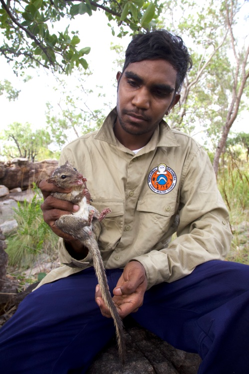
Figure 2. Terrick Bin Sali handling a northern quoll (Dasyurus hallucatus). (Photo WGAC)

Conservation planning with a difference. Our experience has been that the Open Standards can be successfully applied to an Indigenous context but some important adaptation is required. For example:

  1. People, culture and country are inseparable in Australian indigenous worldviews. As such, Healthy Country Planning is much wider in scope than mainstream conservation or natural resource management planning. The vision in the HCP typically sets long-term goals that include aspirations for looking after country and achieving health conditions for landscapes, seascapes, plants and animals, as well as for people and culture (Figs 2-4). These outcomes are collectively referred to as “Healthy Country”. An indigenous plan will always recognize and value people in the landscape rather than as separate. Traditional Owners, and/or their culture, become a conservation target alongside species and habitats with ‘key cultural attributes’ established alongside ‘key ecological attributes’. HCPs also have a greater degree of management strategies that relate to people and culture than would be found in mainstream management plans, and culture and Indigenous Knowledge is incorporated into land management activities that could be considered mainstream, such as the inclusion of cultural rules within visitor management.
  2. The Open Standards include approaches and tools for stakeholder participation that lend themselves well to Indigenous peoples, however given that Indigenous lands are communally-owned and governed by unique law and culture systems, participation requirements are higher and more complex. Traditional systems of governance are often recognized under State and Federal Law (such as the Native Title Act) requiring additional process steps. In developing the HCP, WGAC undertook a process of involving all Traditional Owner families in various stages of planning and the plan was authorized at a Traditional Owner meeting.
  3. A Healthy Country Plan typically applies to the whole traditional estate of a Traditional Owner group regardless of tenure, consistent with the concept of “Country-based Planning”. WGAC initially dedicated stage I of the Uunguu Indigenous Protected Area over several aboriginal reserves in 2010, and later added exclusive possession lands following native title determination. The marine environment will also be added to the IPA once agreement is reached with State and Commonwealth Governments, as articulated in the Uunguu Wundaagu Plan.

Figure 3. Traditional Owners undertaking a ‘junba’ traditional dance workshop. (Photo: WGAC)

Monitoring & evaluation since 2012. Aspects of the monitoring and evaluation framework established by WGAC include the establishment of the Uunguu Monitoring & Evaluation Committee (UMEC) and the completion of mid-term evaluation of the HCP (see 2017 review doi:10.1111/emr.12257). The UMEC is composed of Traditional Owners and external experts who undertake key Healthy Country Planning steps and functions. A significant investment of time and money was required to support annual or biennial meetings “on country” (ie. on Wunambal Gaambera lands), however the review showed that the investment has proven worthwhile because WGAC has been able to implement the plan to a high degree.

In 2015 a major mid-term evaluation was undertaken to assess the progress of the HCP. It utilized some standard evaluation tools examining Open Standards process. It also incorporated some new approaches to include the views of the wider Traditional Owner community in the evaluation of the plan to ensure the plan was meeting their needs and following effective process with regard to governance and participation. The review made a number of observations as follows.

  1. Considerable progress had been made in the implementation of fire management strategies in the HCP to the point that the health condition of the “Right Way Fire” target was changed from ‘fair’ to ‘good’. Unmanaged wildfires have significantly reduced in size as a result of increased capabilities of the Uunguu Rangers to undertake burning. At the same time “right way” cultural principles have been incorporated into operations to ensure that Traditional Owner families are making decisions about burning and undertaking fire operations on their family areas.
  2. Significant progress has been made against a visitor management strategy. One of the key concerns of elders when developing the plan was unregulated visitation to important cultural sites by the expedition cruise industry and independent travelers. The Uunguu Visitor Pass, launched in 2017, requires visitors to obtain a permit to access authorized visitor locations as well as generating funds for looking after country. Over 90% of commercial tour operators have now registered for the UVP, with a similar independent traveler compliance, generating funds to support Traditional Owner participation in visitor management and delivering tour products.
  3. Progress was not made, however, in the health of cultural targets in the plan. As a result, the 2015 review recommended further investment and effort in culture strategies. Two important books have been completed to document elders’ knowledge of biodiversity and cultural places. There has been an increase in cultural activities including language and corroboree dance workshops and annual culture camps for school children. Law and culture dictates that visitors to country (indigenous or non-indigenous) need to be accompanied by the right local Traditional Owners when undertaking activities on country. In this way Healthy Country work supports large numbers of Traditional Owners to visit country and guide participation in the implementation of the plan. A number of actions have been undertaken to support Traditional Owners to live on country and remote ranger infrastructure has been developed.

Figure 4. Uunguu Rangers during a cultural fire walk. (Photo WGAC)

Future Directions. The first 8 years of the HCP implementation has focused on building WGAC’s land and sea management capacity and resources, with funding from WGAC,  the Australian Governments Indigenous Protected Area and Indigenous Ranger Programs and from Bush Heritage Australia. Traditional Owners currently hold certificate level roles of rangers, tourism workers and construction workers but further work is now needed to support Traditional Owners to take on roles that require higher levels of training. There is also a need to support the development of a wider range of livelihoods to support Traditional Owners to live and/or work on country.

Contact information. Wunambal Gaambera Aboriginal Corporation, PMB 16 Kalumburu via Wyndham WA 6740, Australia.

Email: info@wunambalgaambera.org.au

Web: www.wunambalgaambera.org.au

Facebook: https://www.facebook.com/uunguulife/


Restoration and conservation in an iconic National Park – UPDATE of EMR feature

David Lindenmayer, Chris MacGregor, Natasha Robinson, Claire Foster, and Nick Dexter

[Update of EMR feature – David B. Lindenmayer, Christopher MacGregor, Nick Dexter, Martin Fortescue and Peter Cochrane (2013)  Booderee National Park Management: Connecting science and management.  Ecological Management & Restoration, 14:1, 2-10. https://onlinelibrary.wiley.com/doi/10.1111/emr.12027]

Keywords: Invasive animal and plant control, reintroduction, monitoring

Introduction. Booderee National Park is an iconic, species-rich, coastal reserve that supports a range of threatened and endangered native animals and plants. Several key management actions have been implemented to promote the conservation of biodiversity in Booderee National Park. These include the control of an exotic predator (the Red Fox Vulpes vulpes), the control of highly invasive Bitou Bush (Chrysanthemoides monilifera subsp. rotundata), the management of fire, and the reintroduction of previously extinct native mammals. A key part of work at Booderee National Park has been a long-term monitoring program that commenced in late 2002 and which has aimed to quantify the effectiveness of major management interventions, including the four listed above. The monitoring program has documented the long-term trajectories of populations of birds, arboreal marsupials, terrestrial mammals, reptiles, frogs and native plants in a range of major vegetation types (from heathland and sedgeland to woodland, forest and rainforest) and in response to fire, and weed and feral predator control. Importantly, the monitoring program has provided a foundational platform from which a suite of post-graduate studies and other research programs have been completed.

Further works undertaken. A key part of the researcher-manager partnership has been to analyse the long-term trajectories of populations of mammals, birds and reptiles in Booderee National Park. The monitoring data indicate that many species of mammals are declining, with some having become recently locally extinct (e.g. Greater Glider Petauroides volans) or close to extinction in the reserve (e.g. Common Ringtail Possum Pseudocheirus peregrinus) . This is despite populations of these species persisting in nearby reserves.  Robust interrogation of the multi-taxa monitoring data has been unable to identify reasons for these declines. Interestingly, the declines observed for mammals have not been observed to date in other vertebrate groups, including birds, reptiles and amphibians. An experimentally-based reintroduction program for the Greater Glider aims to not only re-establish populations of the species in Booderee National Park, but also to identify the reasons for the original decline. That program will be in addition to reintroduction programs already underway for other mammal species, the Long-nosed Potoroo (Potorous tridactylus), the Southern Brown Bandicoot (Isoodon obesulus) and Eastern Quoll (Dasyurus vivverinus) that used to inhabit Booderee National Park but which went extinct many decades earlier.

Additional research being undertaken in Booderee National Park has included: (1) studies of the effectiveness of control efforts for Bitou Bush and associated recovery of native vegetation and native fauna, (2) the interactive effects of fire and browsing on native plants and an array of animal groups, and (3) studies of leaf litter and other fuel dynamics in relation to previous fire history and macropod browsing.

Figure 1. Key area of Booderee National Park showing an area of coastal forest before and after Bitou Bush treatment.

Further results to date. Research and monitoring in the past six years have resulted in many new insights including some of considerable value for informing restoration programs. A small subset of these findings is outlined below.

  • Conventional approaches to the control of invasive Bitou Bush entail spraying ultra-low volume herbicide (Fig. 1), followed by burning of the “cured” dead material, and then respraying of the seedlings that germinate after fire. This spray-burn-spray protocol is both the most ecologically effective and the most cost-effective way of controlling Bitou Bush and, at the same time, facilitates the recovery of native vegetation. More recent analysis has revealed spray frequency as the most important determinant of long-term control. There are mixed effects of control methods on native species; plant species abundance was positively related to Bitou Bush control, while native bird abundance (except for Eastern Bristlebird Dasyornis brachypterus, Fig 2.) and mammal abundance were weakly negatively associated with Bitou control.
  • There can be strong interactions between the occurrence of fire and browsing by macropods on native plants as well as particular groups of animals such as spiders.
  • Reintroduction programs for the Southern Brown Bandicoot and Eastern Quoll have been relatively successful, although the latter species suffers high rates of mortality, particularly as a result of fox predation and collisions with motor vehicles. Nevertheless, populations of both species have survived over multiple years and reproduced successfully.

Figure 2. The Eastern Bristlebird, a species for which Booderee National Park is a stronghold. Notably, the species responds positively to management interventions to control Bitou Bush. (Photo Graeme Chapman)

Lessons learned and future directions. The work at Booderee National Park is a truly collaborative partnership between reserve managers, a university and the local Indigenous community.  A key part of the enduring, long-term success of the project has been that a full-time employee of The Australian National University has been stationed permanently in the Parks Australia office in the Jervis Bay Territory. That person (CM) works on an almost daily basis within Booderee National Park and this provides an ideal way to facilitate communication of new research and monitoring results to managers. It also enables emerging management concerns to be included as part of adaptive monitoring practices.

One of the key lessons learned from the long-term work has been the extent of ecological “surprises” – that is, highly unexpected results, including those which continue to remain unexplained. An example is the rapid loss of the Greater Glider and the major decline in populations of the Common Ringtail Possum. One of the clear benefits of this integrated monitoring-management team has been the rapid response to emerging threats. For example in response to high rates of mortality of reintroduced Eastern Quolls, control of the Red Fox was intensified within the park and greater cross-tenure control efforts with neighbouring private and public land managers have commenced. Regular evaluation of monitoring data and management actions has also enabled careful examination of the kinds of risks that can compromise reintroduction programs. These and other learnings will inform other, future reintroduction and translocation programs that are planned for Booderee National Park such as that for the Greater Glider.

Stakeholders and funding bodies. Ongoing work has been supported by many funding bodies and partners. These include the Wreck Bay Aboriginal Community who are the Traditional Owners of Booderee National Park as well as Parks Australia who co-manage the park with the Wreck Bay Aboriginal Community. Other key funders include the Department of Defence, the Thomas Foundation, The National Environmental Science Program (Threatened Species Recovery Hub), the Australian Research Council, the Margaret Middleton Foundation, and the Norman Wettenhall Foundation. Partnerships with Rewilding Australia, Taronga Conservation Society, WWF Australia, NSW Forestry Corporation and various wildlife sanctuaries have been instrumental to reintroduction programs.

Contact information. David Lindenmayer, Chris MacGregor, Natasha Robinson and Claire Foster are with the National Environmental Science Program (Threatened Species Recovery Hub), Fenner School of Environment and Society, The Australian National University (Canberra, ACT, 2601, david.lindenmayer@anu.edu.au). Nick Dexter is with Parks Australia, Jervis Bay Territory, Australia, 2540.

Recovery of indigenous plants and animals in revegetated areas at ‘The Waterways’, Victoria.

Photo 1.  Aerial view of Waterways from the west

By Damien Cook

 Introduction. Waterways is a 48-hectare restoration project located on Mordialloc Creek in Melbourne’s south- eastern suburbs which combines a housing estate with large areas of restored habitat set aside for indigenous fauna and flora in open space, lakes and other wetlands (see Photo 1).

Prior to restoration the land at Waterways was a property used for grazing horses and supported pasture dominated by exotic species such as Reed Fescue (*Festuca arundinacea) and Toowoomba Canary Grass (*Phalaris aquatica). (Note that an Asterix preceding a scientific name denotes that the species is not indigenous to the local area).

The habitats which are being restored at “The Waterways” reflect those that originally occurred in the Carrum Carrum Swamp, a vast wetland complex which, prior to being extensively drained in the 1870s, stretched from Mordialloc to Kananook and as far inland as Keysborough.

Local reference ecosystems were selected to act as a benchmark for what was to be achieved in each restored habitat in terms of species diversity and cover. Habitat Hectare assessments have been used to monitor the quality of restored vegetation (see Appendix 1).

A total of nine Ecological Vegetation Classes (EVCs, the standard unit of vegetation mapping in Victoria) are being re-established across the site across the following habitats

  • Open water, Submerged Aquatic Herbfields and Exposed Mudflats
  • Densely vegetated marshes
  • Swamp Paperbark Shrubland
  • Tussock Grassland
  • Plains Grassy Woodland

Photo 2. This sequence of photographs, taken over a nine-month period at the Waterways, shows vegetation establishment in a constructed wetland from newly constructed and bare of native species on the left to well vegetated with a high cover of indigenous plants and minimal weeds on the right.

Works undertaken. Restoration of the site commenced in October 2000. Extensive weed control and earthworks were carried out prior to the commencement of revegetation works, which involved planting, by 2003, over 2 million local provenance, indigenous plants.  Grassland species were planted out of hikos at a density of 5 to 6 per square meter into areas that had been treated with both knock-down and pre-emergent herbicide. Ongoing management of the site has included ecological burning and follow up weed control. When started the Waterways was the largest and most complex ecological restoration project ever undertaken in Victoria.

Results

Plants

Open water, Submerged Aquatic Herbfields and Exposed Mudflats.  Deep, open water areas cover an area of about 30 hectares of the site. Vegetation growing in this habitat includes submerged herb-fields of Pondweeds (Potamogeton species), Eel Grass (Vallisneria australis) and Stoneworts (Chara and Nitella species), which were planted over summer 2000/01.

Densely vegetated marshes. This habitat occupies about 10 hectares of the site, occurring where water is less than 1.5 meters deep around the fringes of the lakes and as broad bands across the wetlands. Swards of large sedges including Tall Spike-rush (Eleocharis sphacelata), Jointed Twig-sedge (Baumea articulata), Leafy Twig-sedge (Cladium procerum) and River Club-rush (Schoenoplectus tabernaemontani); aquatic herb-fields of Water Ribbons (Cycnogeton procerum), Upright Water-milfoil (Myriophyllum crispatum) and Running Marsh-flower (Ornduffia reniformis); as well as meadows supporting rushes, sedges and amphibious herbs. Localized areas with high salinity (4000 to 12 000 ppm) have been planted with a halophytic (salt tolerant) community including Sea Rush (Juncus krausii), Australian Salt-grass (Distichlis distichophylla), and Shiny Swamp-mat (Selliera radicans). Planting began in the marshes at the Waterways in October 2000 and vegetation established very rapidly in most areas (see Photo 2). This vegetation type provides habitat for the locally vulnerable Woolly Water-lily (Philydrum lanuginosum).

Swamp Paperbark Shrubland covers about 8 hectares, consisting of a 1ha remnant and additional areas that were planted in spring/summer 2001. As this shrubland habitat matures it is forming a dense canopy of species including Swamp Paperbark (Melaleuca ericifolia), Prickly Moses (Acacia verticillata subsp. verticillata), Manuka (Leptospermum scoparium), Woolly Tea-tree (Leptospermum lanigerum), Tree Everlasting (Ozothamnus ferrugineus) and Golden Spray (Viminerea juncea).

Photo 3. Rare plant species that have been established in restored native grasslands at “Waterways” include Grey Billy-buttons (Craspedia canens), Matted Flax-lily (Dianella amoena) and Pale Swamp Everlasting (Coronidium gunnianum).

Tussock Grassland covers about four hectares at the Waterways between two major wetland areas. About a third of this habitat was planted in spring 2001, with the remainder in spring 2002. The dominant plants of this habitat are tussock-forming grasses including wallaby grasses (Rytidosperma species), Kangaroo Grass (Themeda triandra) and Common Tussock Grass (Poa labillardierei var. labillardierei). A diverse array of native wildflowers occurs amongst these grasses. Rare plant species that have been established in this habitat zone include Grey Billy-buttons (Craspedia canens), Matted Flax-lily (Dianella amoena) and Pale Swamp Everlasting (Coronidium gunnianum, see Photo 3).

Plains Grassy Woodland This habitat type occurs in mosaic with Tussock grassland and differs in that it supportsscattered trees and clumps of shrubs. River Red Gum (Eucalyptus camaldulensis subsp. camaldulensis) and Swamp Gum (Eucalyptus ovata var. ovata) have been planted so that they will eventually form an open woodland structure. Other tree and tall shrub species planted in this habitat include Drooping Sheoak (Allocasuarina verticillata), Blackwood (Acacia melanoxylon) and the tree form of Silver Banksia (Banksia marginata), which is now very uncommon in the local area.

Seasonal Wetlands Small seasonal wetlands occur within Tussock Grassland (see Photo 4). Rare plant species that have been established in this habitat zone include Swamp Billy-buttons (Craspedia paludicola), Woolly Water-lily (Philydrum lanuginosum), Grey Spike-rush (Eleocharis macbarronii), Giant River Buttercup (Ranunculus amplus) and the nationally endangered Swamp Everlasting (Xerochrysum palustre).


Photo 4. Seasonal rain-filled wetland at Waterways

 Animals.

The Waterways is home to 19 rare and threatened fauna species including the nationally endangered Australasian Bittern (Botaurus poiciloptilus), Glossy Grass Skink (Pseudemoia rawlinsoni) and Magpie Goose (Anseranas semipalmata). The successful establishment of diverse vegetation has so far attracted 102 species of native birds, and the wetlands on the site are home to seven species of frogs.

Open water areas support large populations of Black Swans (Cygnus atratus), Ducks (Anas species), Eurasian Coots (Fulica atra), Cormorants (Phalacrocorax and Microcarbo species), Australian Pelicans (Pelecanus conspicillatus) and Australasian Darters (Anhinga novaehollandiae) that either feed on fish and invertebrates or the foliage and fruits of water plants.  As water levels recede over summer areas of mudflat are exposed. These flats provide ideal resting areas for water birds as well as feeding habitat for migratory wading birds including the Sharp-tailed Sandpiper (Calidris acuminata), Red-necked Stint (Calidris ruficollis) and Common Greenshank (Tringa nebularia) that fly from their breeding grounds as far away as Alaska and Siberia to spend the summer in Australia and are protected under special treaties between the Governments of countries through which they travel.

Photo 5. Magpie Geese (Anseranas semipalmata) at Waterways

In 2007 a small group of Magpie Geese (Anseranas semipalmata) became regular visitors to The Waterways (see Photo 5). This species was once extremely abundant in the Carrum Carrum Swamp. However, it was driven to extinction in southern Australia in the early 1900s by hunting and habitat destruction. The Magpie Goose seems to be making a recovery in Victoria, with numbers building up from birds captured in the Northern Territory and released in South Australia that are spreading across to areas where the species formerly occurred.

Seasonal wetlands are important breeding areas for frogs including the Banjo Frog (Limnodynastes dumerilii), Striped Marsh Frog (Limnodynastes peroni) and Spotted Grass Frog (Limnodynastes tasmaniensis) and a range of invertebrates that do not occur in the larger, more permanent storm water treatment wetlands such as Shield Shrimp (Lepidurus apus viridus). Birds which utilize these wetlands for feeding include the White-faced Heron (Egretta novaehollandiae) and Latham’s Snipe (Gallinago hardwickii).

Restored grassland provides an ideal hunting ground for several birds of prey, including the Brown Falcon (Falco berigora), Black-shouldered Kite (Elanus axillaris) and Australian Kestrel (Falco cenchroides). It also provides cover and feeding habitat for insect and seed-eating birds such as the Brown Quail (Coturnix ypsilophora). A flock of about 20 Blue-winged Parrots (Neophema chrysostoma) have been regularly seen in this habitat. These parrots are usually quite uncommon in the Melbourne area. Moist grasslands beside the wetland have been colonised by the vulnerable Glossy Grass Skink (Pseudemoia rawlinsoni) (see Photo 6).

Densely vegetated marshes provide habitat for a diversity of small, secretive birds such as Ballion’s Crake (Porzana pusilla), Little Grassbird (Megalurus gramineus) and Australian Reed Warbler (Acrocephalus australis), which find suitable refuges in the cover provided by dense vegetation. Dense thickets of Swamp Paperbark shrublands provide cover and feeding habitat for Ring-tail Possums (Pseudocheris peregrinus) and bushland birds such the Eastern Yellow Robin (Eopsaltria australis), thornbills (Acanthiza species), Superb Fairy-wren (Malurus cyaneus) and Grey Fantail (Rhipidura albiscapa). As the grassy woodlands mature they are providing structural habitat diversity and accommodating woodland birds such as cuckoos (Cacomantis and Chalcites species) and pardalotes (Pardalotus species).

It will take many years for the River Red Gums to reach a majestic size and stature, and to provide tree hollows which are essential for many species of native fauna. A limited number of tree hollows are provided in the dead trees (stags) that were placed in the Waterways wetlands.

Photo 6. The vulnerable Glossy Grass Skink (Pseudemoia rawlinsoni) at Waterways

The Future. The habitats that have been created at the Waterways are about 18 years old, yet they have already attracted a vast array of native fauna. Waterways is now home to 14 rare and threatened plant species and 19 threatened animal species. There is incredible potential for the area to provide vitally important habitat for an even greater diversity of rare plants and animals as these habitats mature.

If the area is to reach its full potential careful management of weeds and pest animals is required. Ongoing monitoring of flora and fauna is also necessary. These are both areas in which the local community is becoming involved.

Acknowledgements. The high standard of restoration achieved on the Waterways project was due to the project being appropriately funded and because it was managed by ecologists experienced in planning and implementing ecological restoration.  The project was partly funded by Melbourne Water, who are now the managers of the site, and partly by a developer, the Haines Family.  This unique relationship and the generosity and willingness to try something innovative by the developer were important factors in the success of the project.

Contact: Damien Cook (rakali2@outlook.com.au)

Appendix 1. Habitat Hectare results for four quadrats at Waterways, 2006

Stewartdale Nature Refuge koala habitat restoration in South Ripley, south east Queensland

Key Words: reconstruction, assisted regeneration, planning, koalas, conservation

Introduction: The Stewartdale Nature Refuge is located in South Ripley, south east Queensland on private land owned by the Sporting Shooters Association of Australia (SSAA). The 969 ha block contains live shooting ranges, large open areas dominated by pasture grasses, a substantial lagoon frequented by many bird species and extensive natural areas. The area being restored is 211 ha of dry sclerophyll vegetation, containing a number of Regional Ecosystems (REs) being restored through large scale planting (reconstruction) and assisted regeneration approaches. Its conservation value is heightened by the fact that it connects to the Karawatha Flinders Corridor, the largest remaining stretch of open eucalypt forest in south-east Queensland.

Condition ranges from large degraded areas (i.e. pasture) to native vegetation that contains both regrowth and remnant dry sclerophyll. All areas were impacted by varying levels of weed infestation due to previous clearing and ongoing disturbance from cattle grazing. Natural disturbances such as regular fire and periodic floods have also contributed to disturbance at the site. More than 30 weed species impact the project area at varying levels and the species and impacts vary with the condition of the land. Open areas were dominated by pasture grass such as Setaria (Setaria sphacelata) and Rhodes grass (Chloris gayana) in addition to fast growing annuals, although infestations of Leucaena (Leucaena leucocephala), Prickly Pear (Opuntia stricta) and large clumping Bamboo (Bambusa sp.) also required significant control efforts. In more forested areas (and underneath isolated remnant trees) weed species included Lantana (Lantana camara), Creeping Lantana (Lantana montevidensis), Corky Passionfruit (Passiflora suberosa), Easter Cassia (Senna pendula var. glabrata), Siratro (Macroptilium atropurpureum) and exotic grasses, annuals and groundcovers.

The aim of the project is to restore, native plant communities present within the Stewartdale project site to support local koala populations. Our goals are to:

  • Repair native vegetation including the structure, integrity and diversity to support koala populations
  • Strengthen the resilience and regenerative capacity of native vegetation
  • Restore and expand native regrowth vegetation by controlling weeds
  • Maintain the project site so weeds do not negatively impact the development and recovery of native vegetation
  • Protect drainage lines, gullies and slopes from erosion
  • Protect and enhance the water quality of Bundamba Lagoon
  • Construct fauna friendly fencing across the site with the aim of protecting planted trees from herbivory
  • Reduce the risk of fire moving through the site and impacting restoration works by conducting strategic slashing activities to reduce fuel loads.

Planning. A restoration plan was developed after detailed site assessments and negotiations with the landholder, land manager and state government were finalised integrating Nature Refuge conditions and current land use and future management requirements. The site was divided into zones and sub-zones to assist directing works including applying a range of restoration approaches – i.e. assisted regeneration and reconstruction (‘revegetation’) and several planting models and species mosaics to different parts of the site. Detailed maps were produced for each zone and included information such as the location of all tracks, fences, assisted regeneration zones, wildlife corridors, planting areas according to each RE and numbers of species and plants to be installed per zone. The plan also included detailed information on restoration approaches; weed control at all stages of the project; seed collection and propagation; site preparation including the specifications and location of all fencing, tracks, rip lines and areas of concern (i.e. identified hazards across the site); how to carry out all works in each zone; site maintenance requirements for 5-7 years; and monitoring requirements.

PP2b after site preparation.JPG

Fig 2. Preparation for planting  at Stewartdale Nature Refuge.

PP2b after planting Mar 2016

Fig 2. After planting to support local Koala population, Mar 2016.

Works to date. Site preparation commenced with the collection of seed from on and around the wider property and surrounds ensuring that all species to be planted were collected from a minimum of 10 widely spaced parent trees. Primary weed control started with the control of weeds in the 65 ha of assisted regeneration zones and the control of other woody weeds across reconstruction areas in preparation for slashing and other activities. More than 18 km of fauna friendly fencing (i.e. no barbed wire) was installed to protect planted stock from browsing by large herds of macropods and cows. Two large corridors were retained for fauna to reach Bundamba lagoon from different parts of the regional corridor as it is an important resource for many local and migratory fauna. Slashing across open areas was commenced and followed by the installation of rip lines to alleviate soil compaction and assist efficient planting activities. Weeds and pasture grasses were then sprayed out along all rip lines. 114 000 koala food and shelter trees were planted according to the RE for each section and according to the local conditions (i.e. whether it was low lying, on a ridge or near infrastructure). Some additional frost resistant and local Acacia species were also added to particularly frost prone areas to assist the development of a canopy and the protection of developing vegetation.

The 114 000 tubestock were installed over a 7 week period with the last stems being planted in April 2015. All trees were fertilised and watered at the time of planting and where possible, slashed grass spread across the rip lines to assist retaining moisture and slowing weed regrowth. (Follow-up watering was applied to all planted stock between September and October 2015) Nearly 2000 (1 m high) tree mesh guards were installed to protect planted stock in fauna corridors.

Series shot 1.1

Careful spot spraying to reduce weed while protecting natives

Series Shot 1.2

Growth of saplings is improved without competition.

Results to date. As of March 2016, weeds have been significantly reduced across the 65 ha of assisted regeneration areas. Unfortunately a wildfire fire went through approx. a third of the project area after primary and follow up weed control works had been completed. Fortunately the event was prior to planting though the fire did reduce the number of trees regenerating in assisted regeneration patches as many were too young to withstand the fire. New germinations are however occurring and the level of native grasses, groundcovers and other native species have increased due to ongoing weed control efforts.

Despite heavy frosts in winter 2015, a flood event in May 2015 (150 mm of rain fell in 1.5 hours) and now an extended dry period, the planting is developing well with the average height of trees at over a metre tall and mortality under 5%. Weed control is continuing across the project site with efforts currently concentrating on the control of many annual weeds such as Cobbler’s Peg (Bidens pilosa), Balloon Cotton (Gomphocarpus physocarpus) and Stinking Roger (Tagetes minuta) and many exotic grasses such as Setaria (Setaria sphacelata) and Rhodes grass (Chloris gayana) to reduce competition to planted stock. Assisted regeneration areas are being joined up to planting zones wherever possible to further assist the development of the site.

It should also be noted that Birds Australia have recorded 69 bird species on site.

Ongoing works: Regular maintenance continues on the site with the control of weeds particularly along rip lines where weed germination and growth is rapid. Slashing is also regularly done between the rip lines and along tracks and fence lines to assist access around the site and the management of fuel loads and therefore wildfire across the site. It is expected that the time it takes to complete each maintenance rotation will begin to reduce as plants become more established and start to develop a canopy.

Weed control will also continue in all assisted regeneration zones and is also expected to reduce with the development of native vegetation structure and diversity together with the reduction of the weed seed bank. Ongoing slashing, fence maintenance and monitoring will continue for another 3-5 years though the exact time period will be determined by the State government.

Monitoring including soil moisture readings, transects to assist determining survival rates across the site and photographic monitoring is regular and further supports 6 monthly reporting requirements.

Stakeholders and funding bodies: Department of Environment, Heritage and Protection, Queensland State Government; Sporting Shooters Association of Australia (SSAA). Photos: Ecosure.

Contact Information: Jen Ford (Principal Restoration Ecologist, Ecosure TEl: +61 (0)7  3606 1038.