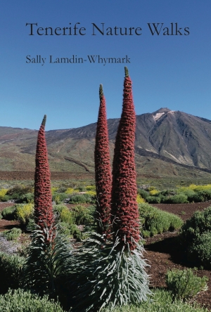
Blog Archives
Camino real route from Guia de Isora to Arguayo and return via Chiguergue
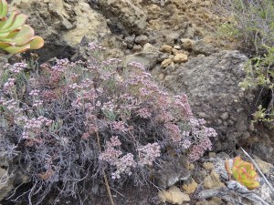
Madama (Allagopappus dichotomus) is a Canary endemic plant which is fairly common in the area
I have lived in Guia de Isora area for 11 years, and walked a great many different footpaths in the area, but have long wanted to walk a part of the south Camino Real (Royal Road) from Guia to Chio. However, I did not know where the Camino Real went after Chio and was delighted to see the route from Guia de Isora as far as Santiago del Teide posted in Wikiloc.com by user ‘tinijoma’. So I planned a walk which followed the Camino Real as far as Arguayo and returned by other footpaths, already known to us, slightly higher up.
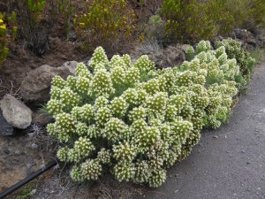
The delicate Canary endemic shrub known locally as Duraznilla (Ceballosia fruticose)
The Camino Real is part of a network of ‘royal roads’ which were directed by the king to be built by the landowners who had been given large areas of land as rewards for participating in the conquest of the island. They were the motorways of the day, linking all the main settlements with wide cobbled paths, enabling communication and trade.
The Camino Real gives some interesting views of the new part of the TF-1 road below.
I walked this route on May 25th with two friends but had not got around to doing a blog about it till now, but wanted to share it as it was an interesting walk both culturally and botanically.
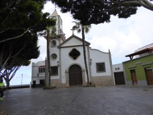
The church in Chio which the route passes
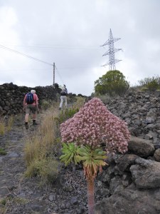
A lot of the botanical interest was that it was the flowering time of the Tenerife endemic Giant Houseleeks – Bejeques in spanish – (Aeonium urbicum ssp meridionale). These plants are short-lived perennials which produce a rosette of succulent leaves on a thick stalk, and may survive several years before producing a large head of flowers and then dying. They grow on the recent lava flows, and other rocky areas, where few other plants are able to survive. Some years there are relatively few in flower, but this year there are huge numbers. Jeff Ollerton, an environmental scientist who does research in Tenerife believes the years when there are a lot in flower occur after a dry winter, and is doing a study to test this hypothesis.
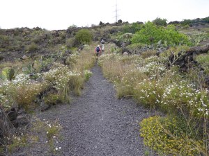
The Camino Real starting the ascent to Arguayo with Tenerife Birds Foot Trefoil (Lotus campylocladus) and marguerites (Argyranthemum spp) along the route
We started our walk from the end of the Avenida de la Constitucion, which is a dead end road on which the Health Centre (Centro de Salud) and a couple of schools are found. My friends call it the ‘road to nowhere’! So it is easy to park towards the far end! We started by heading downhill on a track which appeared at first to be a private drive, not far from the end of the road. However, the track continues beyond the house it passes on a bend and continues down to the TF-82 main road between Guia de Isora and Chio.
This specimen of the Giant Houseleek (Aeonium urbicum ssp meridionale) beside the path is a particularly strong pink colour
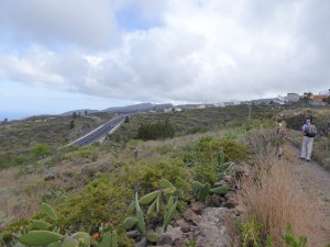
On reaching the road I realised that instead of crossing it onto another track below the road we had to turn right and walk along the road for some 100m before turning off left onto the Camino Real, which was a single lane tarmac road at first, changing later to dirt track, and later still, a footpath. If you are not happy walking along a fairly busy road (though not so busy as it was before the opening of the new road TF-1) for this distance you could start the walk up in Chiguergue and avoid it, though this would shorten the walk also.
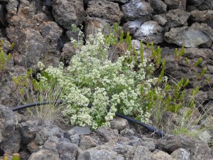
The Canary endemic medicinal plant called Poleo locally (Bystropogon origanifolius)
The Camino Real follows a route below the old TF-82 road and above the new part of the TF-1 road between Guia de Isora and Chio, with some good views down to the new road. Then it climbs steeply up to the village of Chio with huge cobble stones, but not always in place, so this stretch was a bit rough underfoot. Then we walked through the village passing the church on our left and continuing roughly straight on till we left the other side of the village. Then the route grew closer to the new road, ending up at the top of the embankment of the slip road off the road to the Chio junction, finally crossing the TF-82 at a diagonal as it goes down to cross the TF-1.
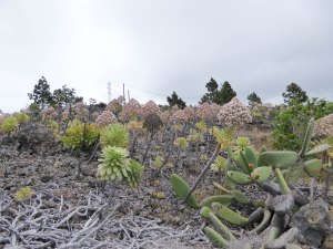
On the malpais (rough aa lava flow) the Giant Houseleeks were making a great show
Then the ascent towards Arguayo began, climbing over malpais, joining the TF-375 road to Arguayo (now quite quiet, with the new road and tunnel), crossing it, and crossing back onto a track past some houses, and joining tarmac as we reached and crossed the TF-375 road again to leave the Camino Real and start our return.
Dicheranthus plocamoides, a Canary endemic known locally as ‘Pata de Gallina’ – Hen’s foot.
We did not go into the village of Arguayo, where you can find shops and bars if you want some food or drink, and could go to visit the pottery museum where you can watch demonstrations of traditional local pottery making. Instead we turned right and walked down in front of the cemetry and took the next track on the left. We followed this track, and the path that continued where the track stopped, through to Chio, taking care on the downhill slope into the village.
Some fine specimens of Lesser white Bugloss (Echium aculeatum) another Canary endemic
Arriving at the TF-82 where it goes through the top of Chio, we turned left and walked along the main road for some hundreds of yards till nearly at the end of the village, just before the pharmacy, we turned left up an initially steep narrow road past Chio’s cemetery. We continued along the narrow road, tarmac at first, then track, then cobbled footpath, until we reached more tarmac just before the village of Chiguergue.
We reached the junction with another small tarmac road, went right and continued on the same road through the top of the village and out the other side. Note that if you want refreshments in Chiguergue you need to go to the bottom of the village. The narrow tarmac road continues towards Aripe through countryside with odd farmhouses. Immediately under a high wall of one of these houses we took a path which wound its way past a vineyard and other fields down to the road where we parked. This path is not well marked and difficult to describe so you need the GPS track to find it easily.
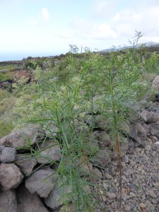
A shrub of Retama (Retama raetam) with its lovely scent, beside the path on the way down to Chio
The GPS track of our walk can be found at the link below:
http://www.wikiloc.com/wikiloc/view.do?id=13445979
The route is 14.59km / 9.1 ml long with 510m /1675ft of ascent and descent and took 3 of us 4.5 hours to complete.
Exploration around and through the Barranco de Tágara

La Palma groundsel (Senecio palmensis) growing up a cliff near the beginning of the walk
Apart from the walk I did on August 8th, 2012 (see the gallery of photos posted on this blog then), I have not walked in the area of the Barranco de Tágara since the devastating fire there nearly a year ago. However, I had been interested in doing so while the forest is more open than before, as my friends and I believed there were paths there we did not know, and finding and exploring them would be easier. So yesterday we went to search out new paths.
We set out from the Mirador de Chio, or Narices del Teide, near km3 on the TF-38 from Boca de Tauce to Chio and walked a little way up the road towards Boca de Tauce and turned right onto a track heading across the malpais (aa lava flow) towards the caldera wall. On the caldera wall I spotted the La Palma groundsel (Senecio palmensis) hanging from a cleft in the cliff. It is an endemic of La Palma, but also of Tenerife. In the malpais were clumps of Shrubby scabious (Pterocephalus lasiospermus), now in full flower.

A fine specimen of Shrubby scabious (Pterocephalus lasiospermus) in the malpais near the start of the walk
The track bends around to the left and on the bend below the cliff was a clump of the endemic Tenerife campion (Silene nocteolens). There were quite a few specimens in the area, mostly beneath rocks or rocky cliffs.

A clump of the endemic Tenerife campion (Silene nocteolens).
We made our way to the fire vigilance watch-tower at the back of Mt Cedro, the focus of a popular walk for our walking group – before the fire, of course. From there we took a path that was renovated not so long ago, heading downhill. It is now well defined, unlike when I first tried to follow it, upwards, before it was renovated! However, we had not gone very far down it when we came across a group of cairns, and some white paint spots, drawing our attention to a path going left which we had never seen before. We had a little discussion and decided to follow it.

The path (on the left between the cairns) starting from near the firetower.
The path headed left along the head of the Barranco de Tágara, with fine views down into it, from directions I had never seen before. It was not the best path ever, but was easy to follow with plenty of cairns and white paint spots. Having crossed the barranco head it headed downhill, getting steeper, and was a bit loose underfoot here. The last couple of hundred yards the cairns and markings disappeared, but we could see a track ahead and just made our way down to it. We found ourselves on a bend in the track where the path from Boca de Tauce to Guia de Isora, the PR-TF 70 passes very close, at point 7 in Walk 9 of the book ‘Tenerife Nature Walks’. This is where that path intersects a path shortcut, which we took, and this resulted in us ending up at point 12A of that walk.

The view down the Barranco de Tágara from near the start of the ‘new’ path.
We were now in the Barranco de Tágara itself, beneath its mighty cliffs and surrounded by trees with deeply charred bark and branches, but amazingly mostly still alive. It is a testament to the resilience of the Canary Pine (Pinus canariensis) that it can survive even such an intense fire as was concentrated in that Barranco last July. A few giant trees which had fallen due to the fire, and which last August we saw still burning, had, of course, died, but the vast majority are sprouting new green shoots up the trunks, giving hope for the future. Meanwhile it still looks a little bare on the ground, although there clearly had been a good showing of Teide marguerites (Argyranthemum teneriffae) this spring, now mostly over. Other ground flora is regenerating rapidly, including Teide wallflowers (Erysimum scoparium) and Pine forest cistus (Cistus symphytifolius), so next spring should have a great show in the Barranco.

Canary endemic ‘Mountain parsley’ (Pimpinella cumbrae) under cliffs in the barranco.
We followed the yellow/white marked PR TF-70 through the Barranco and found the path had been cleared of obstacles such as fallen trees, rocks, etc, which we had encountered last August. There were some rough bits, especially crossing a near vertical streambed, just after passing the Galeria (water mine), but it was all walkable.

Teide marguerite (Argyranthemum teneriffae)

Looking down the Barranco de Tagara from the path
However, as we left the barranco and turned the corner, we found a burnt tree across the path at head-height – easily ducked under – and soon afterwards a huge burnt tree still lying across the path at the point the path from the firetower joins the PR TF-70. It was easily skirted around, but I was surprised it had not been trimmed so the path was clear.

Canarian endemic, Poleo (Bystropogon origanifolius) on the ridge by the second new path
We continued to follow the PR TF-70 path, crossing the Barranco Peguerias, where you still have to go a little way down the streambed to get up to the path on the other side. Out of that barranco the path rises gently till it reaches the crest of a ridge where a signpost points the PR TF-70 downhill. This was where we left that path, as we wanted to explore a path going up the ridge. I had thought it likely this was a minor path, although looking down from above we had been able to see it clearly. It turned out to be a well-constructed proper path with steps in places, and rain-gutters too, so it was a pleasure to walk.

The new ridge path we explored.
As expected, the path joined another path I have walked only once or twice, which crosses the Barranco Peguerias higher up than the PR TF-70. However, we did not turn right at that point to cross that barranco, but went left to cross the Barranco del Cedro, zig-zagging up the far side till we reached the track which accesses the Galeria Salto Gutierrez. The track was a bit overgrown and had some large rockfalls across it, showing it had not had vehicles along it for a long time. As we went along it we discovered why – Charaquete – had washed the track away, though we were able to cross on foot without much trouble.

A pair of robber flies mating on a stone in the middle of the path as we returned to the start
After that barranco we started looking for the path to go back up to where we started. However, we walked right past it as it was badly eroded, and the cairns had fallen. Fortunately the track did a hairpin bend and crossed the path again, where we did see the cairns for the path and started following it up. At first it was very steep, and with the erosion of the path, needed a lot of effort and concentration in placing of feet, but higher up it was less steep and was easier walking, till we reached the malpais. In the malpais it was harder to see the path, and the cairns, but they were there and guided us to a new bit of National Park path, very clearly delineated, on which we went left.

A view of the new national park path in the malpais, looking towards Mt Guajara
The National Park path clearly replaced the previous path I had on which I crossed the malpais several years ago, and it wound its way to the road right opposite the Mirador where we had parked. We had seen the signboard for the path when we started, but had not seen the path, which went to the right from the signboard behind the crash barrier.
The route took us around 6 hours, was 15.4km long and involved 622m of climbing.
A flowery spring walk from Tamaimo up the Santiago valley

Dicheranthus plocamoides growing at the side of the path

The path leaving Tamaimo going up the Santiago valley

Poleo (Bystropogon origanifolius) growing beside the path

A Retama flower (Retama raetam) beside the irrigation channel next to the path. The Retama bushes had very few flowers in this area this year.

The path further up the valley

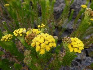
The yellow-flowered Canary tansy (Gonospermum fruticosum) next to a flowerless Retama bush

The local endemic Viper’s bugloss (Echium aculeatum)

The path out of El Molledo passes by this wide dyke of (formerly!) molten rock intruded into existing rock.

The very striking caterpillar of a Leafy spurge hawkmoth (Hyles euphorbiae)

The Canary sage (Salvia canariensis)

Aeonium sedifolium growing on another dyke running along the top of the ridge to the north of Tamaimo

The ridge path approaching the junction of paths where we turned left to return to Tamaimo

Tenerife samphire (Vieraea laevigata) growing on the rocky cliffs above the path descending to Tamaimo. It is a Tenerife endemic found only in the Teno region
These last two weeks I have been very busy and I am going away again in a couple of days, so I do not have time to write a full description of the walks I have done recently which have been so enjoyable with all the spring flowers to see. So I am just posting the photos to give my followers an idea of the flowers that I have seen.