Blog Archives
Camino real route from Guia de Isora to Arguayo and return via Chiguergue
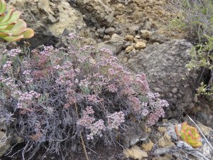
Madama (Allagopappus dichotomus) is a Canary endemic plant which is fairly common in the area
I have lived in Guia de Isora area for 11 years, and walked a great many different footpaths in the area, but have long wanted to walk a part of the south Camino Real (Royal Road) from Guia to Chio. However, I did not know where the Camino Real went after Chio and was delighted to see the route from Guia de Isora as far as Santiago del Teide posted in Wikiloc.com by user ‘tinijoma’. So I planned a walk which followed the Camino Real as far as Arguayo and returned by other footpaths, already known to us, slightly higher up.
The delicate Canary endemic shrub known locally as Duraznilla (Ceballosia fruticose)
The Camino Real is part of a network of ‘royal roads’ which were directed by the king to be built by the landowners who had been given large areas of land as rewards for participating in the conquest of the island. They were the motorways of the day, linking all the main settlements with wide cobbled paths, enabling communication and trade.
The Camino Real gives some interesting views of the new part of the TF-1 road below.
I walked this route on May 25th with two friends but had not got around to doing a blog about it till now, but wanted to share it as it was an interesting walk both culturally and botanically.
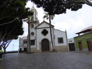
The church in Chio which the route passes
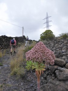
A lot of the botanical interest was that it was the flowering time of the Tenerife endemic Giant Houseleeks – Bejeques in spanish – (Aeonium urbicum ssp meridionale). These plants are short-lived perennials which produce a rosette of succulent leaves on a thick stalk, and may survive several years before producing a large head of flowers and then dying. They grow on the recent lava flows, and other rocky areas, where few other plants are able to survive. Some years there are relatively few in flower, but this year there are huge numbers. Jeff Ollerton, an environmental scientist who does research in Tenerife believes the years when there are a lot in flower occur after a dry winter, and is doing a study to test this hypothesis.
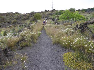
The Camino Real starting the ascent to Arguayo with Tenerife Birds Foot Trefoil (Lotus campylocladus) and marguerites (Argyranthemum spp) along the route
We started our walk from the end of the Avenida de la Constitucion, which is a dead end road on which the Health Centre (Centro de Salud) and a couple of schools are found. My friends call it the ‘road to nowhere’! So it is easy to park towards the far end! We started by heading downhill on a track which appeared at first to be a private drive, not far from the end of the road. However, the track continues beyond the house it passes on a bend and continues down to the TF-82 main road between Guia de Isora and Chio.
This specimen of the Giant Houseleek (Aeonium urbicum ssp meridionale) beside the path is a particularly strong pink colour
On reaching the road I realised that instead of crossing it onto another track below the road we had to turn right and walk along the road for some 100m before turning off left onto the Camino Real, which was a single lane tarmac road at first, changing later to dirt track, and later still, a footpath. If you are not happy walking along a fairly busy road (though not so busy as it was before the opening of the new road TF-1) for this distance you could start the walk up in Chiguergue and avoid it, though this would shorten the walk also.
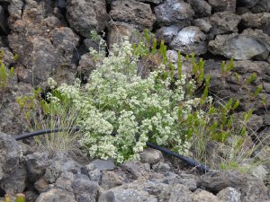
The Canary endemic medicinal plant called Poleo locally (Bystropogon origanifolius)
The Camino Real follows a route below the old TF-82 road and above the new part of the TF-1 road between Guia de Isora and Chio, with some good views down to the new road. Then it climbs steeply up to the village of Chio with huge cobble stones, but not always in place, so this stretch was a bit rough underfoot. Then we walked through the village passing the church on our left and continuing roughly straight on till we left the other side of the village. Then the route grew closer to the new road, ending up at the top of the embankment of the slip road off the road to the Chio junction, finally crossing the TF-82 at a diagonal as it goes down to cross the TF-1.
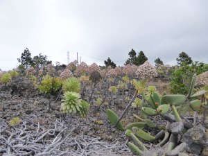
On the malpais (rough aa lava flow) the Giant Houseleeks were making a great show
Then the ascent towards Arguayo began, climbing over malpais, joining the TF-375 road to Arguayo (now quite quiet, with the new road and tunnel), crossing it, and crossing back onto a track past some houses, and joining tarmac as we reached and crossed the TF-375 road again to leave the Camino Real and start our return.
Dicheranthus plocamoides, a Canary endemic known locally as ‘Pata de Gallina’ – Hen’s foot.
We did not go into the village of Arguayo, where you can find shops and bars if you want some food or drink, and could go to visit the pottery museum where you can watch demonstrations of traditional local pottery making. Instead we turned right and walked down in front of the cemetry and took the next track on the left. We followed this track, and the path that continued where the track stopped, through to Chio, taking care on the downhill slope into the village.
Some fine specimens of Lesser white Bugloss (Echium aculeatum) another Canary endemic
Arriving at the TF-82 where it goes through the top of Chio, we turned left and walked along the main road for some hundreds of yards till nearly at the end of the village, just before the pharmacy, we turned left up an initially steep narrow road past Chio’s cemetery. We continued along the narrow road, tarmac at first, then track, then cobbled footpath, until we reached more tarmac just before the village of Chiguergue.
We reached the junction with another small tarmac road, went right and continued on the same road through the top of the village and out the other side. Note that if you want refreshments in Chiguergue you need to go to the bottom of the village. The narrow tarmac road continues towards Aripe through countryside with odd farmhouses. Immediately under a high wall of one of these houses we took a path which wound its way past a vineyard and other fields down to the road where we parked. This path is not well marked and difficult to describe so you need the GPS track to find it easily.
A shrub of Retama (Retama raetam) with its lovely scent, beside the path on the way down to Chio
The GPS track of our walk can be found at the link below:
http://www.wikiloc.com/wikiloc/view.do?id=13445979
The route is 14.59km / 9.1 ml long with 510m /1675ft of ascent and descent and took 3 of us 4.5 hours to complete.
Revisiting the Barranco de Erques walk, with a shorter version

The path descending the opposite side of the Barranco near the start (and end) of the walk
I wrote a blog about this walk earlier this year, on 15th February, entitled ‘The Barranco de Erques, Vera de Erques and Tejina’. However, one friend who did not go on that walk wanted to do it too, so we chose to do it on 30th July. Normally we would not have walked it in the summer, due to lack of shade, but this was a cloudy day. It was, however, quite humid and warm, so the climbing was a little sticky, and we decided to do a shorter version, missing out the Camino Montiel and Las Fuentes, and heading down from Vera de Erques to complete a shorter circle.

The Sea Rosemary (Campylanthus salsaloides) was still in flower
Consequently, when we reached the main square of Vera de Erques, near the church, we turned left and took the next left off that road to descend a road that wandered around various attractive houses and gardens and join the main road lower down, where we crossed it, going slightly to the right to take a path descending from the bend. The path follows the southern edge of a barranco till it reaches a small group of houses, and a narrow tarmac road which we continued on for a few yards before taking a sharp right turn to descend into the barranco on the path again. This part passes numerous animal pens for dogs, chickens, rabbits and even a small black pig, before crossing the streamed and ascending the opposite side.

Madama (Allagopappus dichotomous) still in flower beneath a rock overhang beside the path ascending out of the Barranco de Erques
The path then crossed a concrete driveway and continued along a house wall before turning downhill again. Lower down the path turned right to cross another barranco, but this time we went straight on to join a track passing some buildings. The track joined the main road going up to Vera de Erques again, and we went right on it to a hundred metres or so, turned right onto the road to Tejina, and then turned left off that road about 100m further on.

The path, Camino La Morra, heading back towards the Barranco de Erques, with water pipes.
Within a few metres we turned onto a dirt track going straight ahead, instead of following the tarmac road to the right, slightly lower than the track. We were now back on the route returning to the Barranco de Erques crossing which we started at.

Lesser white bugloss (Echium aculeatum) was still in flower in a damp spot along the Camino la Morra
This shorter version of the walk was only 8.72km as opposed to 12.03km for the longer version. It took us 4.25 hours at a slower pace due to the warmth and humidity.

The Camino La Morra ascending to the village of Vera de Erques along the edge of the Barranco de Erques
(Update 2.3.2015) A GPS track of this shortened walk is now available on Wikiloc:
http://www.wikiloc.com/wikiloc/view.do?id=8983364

Some fine bunches of ripening grapes hanging over a wall in the village of Vera de Erques

The red, 3-cornered seed heads of the Canary spurge (Euphorbia canariensis)

Cardo de Cristo, or Willow-leaved carline thistle (Carlina salicifolia)
A circular walk from Santiago del Teide with plenty of flowers

Several flowering shrubs of Lesser White Bugloss (Echium aculeatum), an endemic of the Western Canary Islands
I walked this route with a few friends last Wednesday, 23rd April, and the area was so green and so many flowers were out that I had to blog about it. Some of the flowers were the local endemics, others were common mediterranean plants, but they all were a delight.

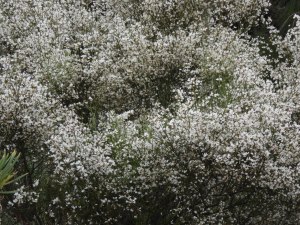
Retama bush (Retama rhodorhizoides) in full flower. The scent is gorgeous.
We set off from the barbecue park on the edge of Santiago del Teide, near the church, along the road in the direction of Erjos and the north. We passed the turning to Valle de Arriba and continued along the main road to the next corner where we took the footpath up the hill. As we approached the footpath we could already see lots of bushes of Lesser white bugloss (Echium aculeatum) an endemic of the western Canary Islands, and Retama (Retama rhodorhizoides) bushes, both covered in white flowers. The Retama is also a Canary endemic.

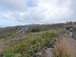
The view back towards Santiago del Teide from half-way up the initial climb
The footpath started uphill gently and in shade, but soon got steeper, and out in the sun, so we had a few stops to admire the view and look at wildlife. We heard a Barbary Partridge (Alectoris barbara koenigi) repeatedly giving an unusual call, a loud note rising at the end, which we think must have been a mating call. We looked where it was coming from and were amazed to see the Partridge in the branches of a dead shrub. I have never seen one standing on anything other than the ground, and only leaving that in flight very reluctantly when feeling threatened.

A Barbary Partridge (Alectoris barbara koenigi) on the branches of a dead shrub
Shortly afterwards we saw the first of numerous Small Copper butterflies (Lycaena phlaeas). During the course of the walk we also saw lots of other butterflies, including Canary Red Admirals, Canary Blues and Small Whites.

Small Copper butterfly (Lycaena phlaeas) on a Milk Thistle (Silybum marianum)

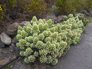
Roof houseleek (Aeonium urbicum var meridionale), another Canary endemic found only on Tenerife in the Teno and Santiago del Teide area
As we climbed we saw one specimen of the Roof Houseleek (Aeonium urbicum var meridionale) in flower. It only grows in the Santiago del Teide and Teno area, with lots growing on the lava flows (malpais) around Arguayo, but this one was on its own.

A view of Teide from the track down from Mt Gala
The path reaches the end of a track, but continues upwards to the ridge where some superb views of Teno can be seen, but we went right, walking along the track which winds its way around the slopes of Mt Gala with its fire watchtower and communications masts on top. The track reaches a narrow tarmac access track on a ridge. This is the access to the masts and tower on Mt Gala, and runs down a ridge which marks a watershed between the north and south of Tenerife. It is noticeably greener on the northern side, due to more rain from the north-easterly prevailing winds. We turned right to descend the track till we were not far from the main road, before turning left down a very old, partly cobbled footpath down towards the Erjos lakes. At the bottom we turned right to go up to the main road again, joining it near to the Restaurant Fleytas. Taking this little diversion avoided walking along the main road on some dangerous bends.

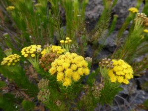
Cineraria (Pericallis echinata) another Canary endemic
We walked on the main road a short way, past the Restaurant Fleytas, took the road to the left after the bus-stop and turned left again before the first house, onto a concrete track. This took us down and then up past some cultivated fields. The field edges, and some uncultivated areas were awash with wildflowers such as Common poppies (Papaver rhoeas), Tangier peas (Lathyrus tingitanus), and Lathyrus articulatus, with Milk thistles (Silybum marianum) and many other vetches and other common flowers.

Tangier pea (Lathyrus tingitanus) was abundant on the northern side of the watershed
The concrete road joins the road to San Jose de los Llanos, we turned left along it for a short distance till we reached a roundabout by the newly completed rural museum which is still not opened. Here we turned right and immediately right again to go around a very fine large pine tree and along a track around Mt Tamaseche. The track runs parallel but higher than the road for a while before turning to the south. The track had lots of flowers either side including the Tree Sow-thistle (Sonchus canariensis) which is common in this area, the Pine Cistus (Cistus symphytifolius), with its large papery pink flowers, Tree heaths, (Erica arborea) and Sticky broom (Adenocarpus foliosus), a Canary endemic. We stopped for our lunch on a bend in the track overlooking the lovely fertile valley of Valle de Arriba.

Lathyrus articulatus, another plant of the sweet pea family which was abundant on this walk
After this bend the landscape was more south facing and noticeably more open, although the uncultivated fields were still very green, but in places had a haze of carmine in them. Closer examination identified the carmine haze as carpets of Field Gladiolus (Gladiolus italicus) in amongst the grass.

Field Gladiolus (Gladiolus italicus) is common in the fields above Valle de Arriba
The track goes through a narrow gap where it is a bit rough underfoot and not long after there is a track junction where we went right. This goes through an area with a lot of fig trees in fields which are largely uncultivated, but are full of wildflowers. We passed just one group of yellow-flowered shrubs of the broom family. I have seen them before and believe them to be Teline stenopetala, a macronesian endemic which is more common in the north of the island.

Atlantic Islands Whin (Teline stenopetala), a macronesian endemic
At a T-junction of tracks we turned right and soon met the tarmac road which goes to the shrine above Valle de Arriba. We turned right to go down it, although some of us took a short-cut on the footpath lower down. Either way we walked down to the village of Valle de Arriba and through it back to Santiago del Teide.
At a T-junction of tracks we turned right and soon met the tarmac road which goes to the shrine above Valle de Arriba. We turned right to go down it, although some of us took a short-cut on the footpath lower down. Either way we walked down to the village of Valle de Arriba and through it back to Santiago del Teide.
The walk was 12.75 km / 7.9 mls long with 444m / 1458 ft of ascent and descent. It took us nearly 4.5 hours at a leisurely pace.
A flowery spring walk from Tamaimo up the Santiago valley

Dicheranthus plocamoides growing at the side of the path

The path leaving Tamaimo going up the Santiago valley

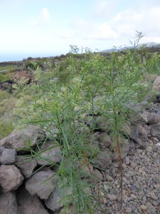
Poleo (Bystropogon origanifolius) growing beside the path

A Retama flower (Retama raetam) beside the irrigation channel next to the path. The Retama bushes had very few flowers in this area this year.

The path further up the valley

The yellow-flowered Canary tansy (Gonospermum fruticosum) next to a flowerless Retama bush

The local endemic Viper’s bugloss (Echium aculeatum)

The path out of El Molledo passes by this wide dyke of (formerly!) molten rock intruded into existing rock.

The very striking caterpillar of a Leafy spurge hawkmoth (Hyles euphorbiae)

The Canary sage (Salvia canariensis)

Aeonium sedifolium growing on another dyke running along the top of the ridge to the north of Tamaimo

The ridge path approaching the junction of paths where we turned left to return to Tamaimo

Tenerife samphire (Vieraea laevigata) growing on the rocky cliffs above the path descending to Tamaimo. It is a Tenerife endemic found only in the Teno region
These last two weeks I have been very busy and I am going away again in a couple of days, so I do not have time to write a full description of the walks I have done recently which have been so enjoyable with all the spring flowers to see. So I am just posting the photos to give my followers an idea of the flowers that I have seen.
Pleasant walk from Valle de Arriba

The path up the valley from Valle de Arriba
This walk is a pleasant one, with a variety of different landscapes, some nice views but mainly gentle climbs and descents. It is in a figure of eight, so although it is a fairly long walk, it could be cut to less than half by making a circle instead of an eight. The full walk is 15.7km/9.8miles, with 454m/1490ft of ascent and descent, and took us 4 hrs 38 mins. If you did just a circle from Valle de Arriba it would take just 2 hours, 5.9km/3.7miles with only about 200m/660ft of ascent and descent.

Looking towards the newly build Agricultural Museum that is yet to open
In Valle de Arriba we parked near an electricity pylon in the road just beyond the church. The road is wider there because of the pylon so there is some space for parking. From there we walked up the road in a northerly direction, ignoring a turning right and keeping straight on to the end of the tarmac. Then we turned to the right on a track, then soon after, left up a slope onto the path. The path goes up a valley in a northerly direction. This area was badly affected by the 2007 forest fire and you can still see the blackened skeletons of the shrubs that were burnt. However, new young shrubs are growing up in their place, and the signs of birdlife, shows that the area is recovering. There were a lot of Lesser white bugloss (Echium aculeatum), the local endemic form of the Viper’s bugloss, up this valley, flowering at the moment and interesting the bees. There was also a fine clump of Retama (Retama raetam) not far from the path, all in flower, but too far away for us to enjoy the scent.

Lesser white bugloss (Echium aculeatum)
At the top of this path you reach a road, the one from the Restaurant Fleytas to San Jose de los Llanos and La Montañeta. We went to the right on a faint path with cairns to climb up to the track that goes round the mountain to the right, Mt de Tamaseche. However, the path up there is quite steep and might not suit everyone, so if you prefer you can go right and walk along the road for 0.5km/0.3m till you get to a roundabout and turn right. If you climb the steep path to the track, you go left on the track and circle the mountain, with the road below you till you get to the same level at the roundabout where there is a large old pine tree. Along the track are some plants and flowers of interest, including Madeiran sorrel (Rumex maderensis), Cineraria (Pericallis echinata) and Sticky broom (Adenocarpus foliosus), all of which were in flower. Turn right here and go up a track. After the initial stretch with the tree-covered mountain to your right, the views open out, including a good view up to Mt Teide.

Madeiran sorrel (Rumex maderensis)
After walking about 900m/1000yds up the track from the roundabout, (about 1hr of walking from the start in Valle de Arriba), you reach a crossroads of tracks. This is the crossing point of the figure of 8, and if you want a short walk turn right here. Otherwise go left. The track goes on past open fields and then enters the edge of a pine-dominated woodland with evergreen shrubs of Faya (Myrica faya) beneath them. Continue along this track till you get in sight of a substantial white-painted building, fenced off with chain-link fencing. Before you get to this building, which is a drinking water reservoir, turn right onto a track doubling back to your right.
After 5 minutes walking along this track, (about 0.5km/0.3m) start looking to the left for a large cairn and the start of a footpath, with stones lined up each side. If you miss the path at first keep looking to the left for it as it is in sight of the track for some way, but move onto it as soon as you see it as the track turns to the right and you want to be going to the left with the path.

View of Volcan Negro on the left, Mt Teide and Pico Viejo to the right
This path is part of the PR-TF-43 complex and you are on the path which goes from San Jose de los Llanos to Chinyero. It has yellow/white standard signage and parallel paint marks. After about 30 minutes walking through pleasant forest the path goes up a steep slope of black ‘sand’ to arrive at a track near the Volcan Negro on the left. There are views to Mt Teide and Pico Viejo straight on. A covered channel crosses the landscape of black ‘sand’ parallel with the track. This is the Vergera canal which takes water from ground-water resources in the Barranco de Vergera above Los Realejos in the north to Guia de Isora. A signpost with the yellow/white livery directs you right, over the canal, towards Chinyero.
We passed another pleasant 30 minutes walking across the black ‘sand’ in amongst trees, and past rocks with orange stringy lichens and yellow Houseleeks (Aeonium spathulatum) flowering among the rocks. We had gone straight on at a path junction with a left turn signed to Arenas Negras and Garachico, and then shortly afterwards we had reached a signpost pointing in two directions for the Chinyero circular path. Here we went right, but we did not continue with the yellow/white path where it went left off the track after a few yards, instead we stayed on the track to take a shortcut, till a yellow/white marked path crossed the track after 15 minutes of walking, where we turned right to start our descent.

Houseleek (Aeonium spathulatum) growing in the lava rocks
We stayed on the yellow/white marked path, now heading for ‘Partidos de Franquis’ till we got back to the cross roads of tracks where our figure of 8 joins in the middle. We turned left and walked along the track taking the 2nd track on the left, after 12 minutes of walking. We then followed that track till a T-junction of tracks, turned right and met a narrow tarmac road which winds its way up to the end of the Chinyero lava. Going right on the tarmac we soon spotted our path on the right which took us back to Valle de Arriba by a more direct route than the road. Once in the village, and on tarmac we continued downhill, did a sharp right turn, then a left, left again and we were back to the cars.
You will find a downloadable GPS track of the walk, on maps at the following site: