Blog Archives
A nature walk in the dramatic Barranco de Badajoz, Guimar
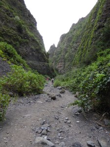
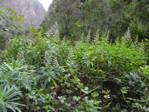
Looking up the barranco as it narrows.
I have wanted to visit the Barranco de Badajoz for a long time as I was aware of its historical interest and biodiversity. However I always thought it was a rather short walk for my energetic walking friends, and too difficult underfoot for my less active friends. However, I was proved wrong on both counts when I finally visited it on Saturday, 19th March.
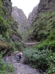
Approaching the canal bridge across the barranco after which the path becomes very rough
The Barranco de Badajoz is known historically for being the last stronghold of the resisting guanche population after the spanish invasion. However, I was interested more in the wide range of interesting and endemic plants that grow there. Usually such a barranco would be extremely difficult to walk up, due to large boulders, etc, but this was not the case until the last 100m or so before the end point where the barranco becomes almost vertical some hundreds of metres high.
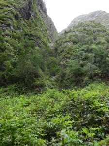
The lush greenery where a side ravine joins the main barranco.
The path up the barranco is a driveable (4×4) track for a great part of the way, and then becomes an easy sand/gravel path until you reach a decaying and unused concrete water channel bridge overhead just below the Galeria Izana. Only then does the path deteriorate to a rubbly scramble through bramble bushes till you reach a very narrow gorge, only a couple of metres at its narrowest, where the cascade chain begins.
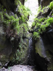
The final end to the trail, the narrow gorge through which the water gushes after a near vertical fall of 2-300m.
We began our walk from near the church in the village of San Juan in the Guimar valley where there are a number of parking places and a nice friendly little bar for our end of walk drinks. However, if we had wanted to shorten the walk further we could have driven a further kilometre to park on the side of the barranco itself, or even further than that.
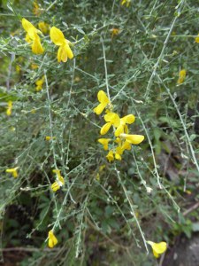
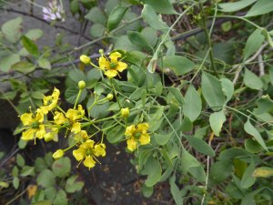
A rare Canary endemic broom Teline osyroides
On entering the barranco it is fairly wide, with small farms either side on the slopes. Gradually as you walk up the barranco sides close in and get steeper and the farms get fewer and then disappear. Half way up the barranco is a concrete and cobbled ramp which takes you past a gallery entrance on the left and through a narrow gorge on a bend in the barranco. Afterwards the barranco widens again but from this point on, the richness of the plant life and the breathtaking scenery are amazing.
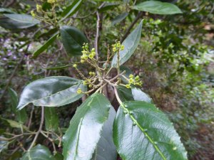
Flowers and leaves of Atlantic Island Buckthorn – Sanguino – (Rhamnus glandulosa)
Immediately after the gorge there is a group of evergreen small trees including Atlantic Islands buckthorn – Sanguino in spanish -(Rhamnus glandulosa), Spiny Buckthorn – Espinero – (Rhamnus crenulata), Canary maytenus – Peralillo – (Maytenus canariensis), and mixed in with them some Wild Olive (Olea europea). Also luxuriant growth of shrubs and climbers such as Shrubby Burnet – (Bencomia caudata), Forest Bindweed – Corregüelón de monte – (Convolvulus canariensis) and Madder – Azaigo de risco (Rubia peregrina ssp agostinhoi).
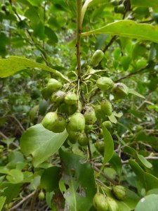
Canary Maytenus (Maytenus canariensis) and its fruits
At the sides of the path and tracks can be found Pinnate Rue (Ruta pinnata), False sages (Sideritis oroteneriffae), Viper’s Buglosses of two species (Echium virescens) and (Echium strictum), an endemic broom (Teline osyroides) and Canary St Johns Wort (Hypericum canariensis) among many other things.
Rough-leaved bugloss (Echium strictum) in a mass of vegetation – another Canary endemic
On the steep slopes are forests of ferns, lots of native sow thistles (Sonchus sp.), native Cinerarias (Pericallis sp.) and so much more. Even in the luxuriant brambles near the end of the trail an endemic of the stinging nettle family can be found (Urtica morifolia).
Pinnate Rue – Ruta pinnata – a Canary endemic.
The walk took us 3.5 hours at a leisurely pace with plenty of time to look at the plants. We walked 8.5 km / just over 5 miles and climbed approximately 310m on a gentle incline. As mentioned above, starting the walk 1km further on, and finishing a little sooner could have reduced the distance by 2-3 km, and, as it is a there and back walk one can walk as little or as much as desired. However, I do recommend going past the concrete and cobble ramp and through the gorge to see the best biodiversity.
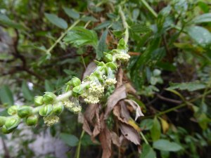
The flowers of Shrubby Burnet (Bencomia caudata), a Macronesian (Atlantic islands) endemic
You can find various walks to the Barranco de Badajoz on the wikiloc.com site to help you get to the beginning. Clearly the higher reaches of the barranco with high vertical cliffs does not lend itself to accurate GPS tracks.
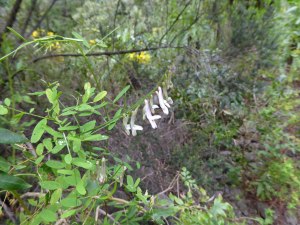
Vicia cirrhosa – an annual vetch which scrambles over other shrubs is another Canary endemic
North to South in the Anaga peninsula

The path above Taganana with Aeonium lindleyi on the wall
Last Friday a friend and I did a great walk from Taganana in the North of Anaga to the village of Maria Jimenez on the south coast near Santa Cruz. It was a scenic and varied walk, with parts through farmland, laurel forest and dry south-facing zone. We were lucky with the weather, despite some cloud near the summit when we were in the forest zone, we were able to enjoy the views of the rugged landscape the rest of the way.

Scabiosa atropurpurea in the path above Taganana
We reached Taganana on the bus no 946 and started out on PR-TF 8 which starts near the church, and is signposted and waymarked with yellow/white livery. This path is also called Las Vueltas de Taganana. You follow the road round the barranco and just after passing a Pharmacy on the right, look for the turning left up a steep cobbled street. At the top of that street follow the signs round to the left in front of some houses and then on upwards, becoming a path, although still well-cobbled. The walls at the side of the path were well hung with plants of Aeonium lindleyii with its yellow flowers.

Small Copper butterfly (Lycaena phlaeas) on the path
As we climbed away from Taganana, I saw in the path some Scabious (Scabiosa atropurpurea) plants I had never before seen in Tenerife. Apparently they are probably an introduced species and only found in certain localities. Around the same area I also caught sight of a Small Copper butterfly (Lycaena phlaeas). Although the book I have about Canarian butterflies says this butterfly flies all the year round, I have only ever seen it in the summer myself.

Sanguino (Rhamnus glandulosa)
Higher up the fields either side of the path started giving way to shrubs such as Tree Heaths (Erica arborea) and various evergreen laurel-type species such as Faya (Myrica faya) and Sanguino (Rhamnus glandulosa). The latter is of the buckthorn family and one specimen beside the path was full of berries. You can see in the picture the lumps on the leaves (glands) which give it its latin name.
In this open shrubby area I also saw 3 Cleopatra butterflies (Gonepteryx cleobule), a bright yellow species similar to and related to the Brimstone (Gonepteryx rhamni) butterflies in Britain. Interestingly, both species feed on buckthorn species as caterpillars, which may explain why I saw the Cleopatras in that area. Unfortunately I was unable to get a picture of any of the 3 as they were too busy chasing each other!

Laurel forest Parsley (Cryptotaenia elegans)
Soon afterwards the path plunged into the deeply shaded thick laurel forest. It was damp in the forest, and higher up the path became quite slippery so we were glad we were climbing rather than descending. However, due to the dampness there were lots of plants to see including the majority of the flowers I saw that day. These included Canary Islands Buttercup (Ranunculus cortusifolius), although they were nearly over, Laurel forest Parsley (Cryptotaenia elegans), a delicate umbellifera a bit like Cow Parsley, Reina del Monte (Ixanthus viscosus), Large-leaved St John’s Wort (Hypericum grandifolium) and Milky Cineraria (Pericallis appendiculata). All of these species are typical of the laurel forest and are all Canary endemics, except for the Buttercup, which, despite its name, is a Macronesian endemic as it is found on some other Atlantic islands.

Part of the path through the laurel forest with Woodwardia radicans ferns on the left. The dark lump on the tree trunk further up is Laurobasidium lauri.
In the laurel forest I also noted four different types of fern, including the magnificent and huge Woodwardia radicans which, in places, covers the banks of the path with its giant drooping fronds.
Low down in the laurel forest there were some trees with huge laurel-like leaves, much bigger than any of the other species seen in the forest. I believe them to be Delfino (Pleiomeris canariensis), which is one of the less common trees of the laurel forest. However I am reluctant to definitely identify them as Delfino until I have seen them in flower or fruit to confirm the identification. I was pleased also to see a fine specimen of the fungus Laurobasidium lauri which grows only on Canary Laurel (Laurus novocanariensis) trees.
Still in the laurel forest, and after about 2 hours of walking, we reached a signpost with two alternative routes, and we turned left. We were now on the ridge running the length of the Anaga peninsula. After a little more climbing we took a right fork in the path and began to gently descend, still beneath Tree Heaths, so we could not get our bearings well. When the path began to descend more steeply, the shrubs diminished in height and we finally had a view down to the south coast, and Santa Cruz. Even further down we suddenly came upon a break in the bushes which gave us a view along the valley we were descending into, the Valle Brosque. The path descended rapidly, zig-zagging to make it bearable. There was a strong wind blowing on this stretch of the walk and we had to take care we did not lose our balance with the gusts on bends.

The view down to the village of Valle Brosque
Beside the path as we descended were areas between the shrubs covered in Houseleeks which I believe were Aeonium canariense, though the flowers were distorted possibly by the drought. They weregrowing with Shrubby Plantain (Plantago arborescens) and Tomillo (Micromeria). The shrubby cover included Tejo (Erica scoparia ssp platycodon) as well as the Tree Heath. This is another heather species which grows tall like a tree, but not as tall as the Tree Heath. Further down the shrubs belonged to the xerophytic zone, dry-tolerant species such as Bitter Spurge (Euphorbia lamarckii), Canary Spurge (Euphorbia canariensis), Mosquera (Globularia salicina), Incienso (Artemesia canariensis) and Prickly Pears (Opuntia spp). There were also a number of trees with leathery evergreen pinnate leaves which I was curious about, that turned out to be Carob Trees (Ceratonia siliqua), planted to provide fodder for animals.

Houseleeks (prob. Aeonium canariense) with shrubby plantain (Plantago arborescens) on the descent to Valle Brosque
The path was coming down to a group of houses when we reached a signpost indicating another path to the right going up to the ridge, or an alternative to the left stating there was a bus-stop 60m away. We went that way, but were not hopeful about the bus. At 60m, or there about, we reached tarmac. Seeing no information about bus times, we decided to carry on walking down the valley towards the coast road where we knew there were buses every 10 mins at that time of day. However, the walk on the road was about 4.5 km and took us an hour to walk down. Half-way down we met a small bus coming up – the 916. We thought if it passed us again on the way down we would hail it. However it did not overtake us till we were nearly at the coast road and had taken a pedestrian street, so missed it. However, we did not wait long at the bus-stop on the main road.
The walk was a total of 14.9km / 9.3ml, and involved around 880m/2900ft of climbing. It took us 4hrs 50m. If you looked up the times of the 916 bus before you went you could shorten this by 4.5km and 1hr.