


Mere days ago, Chicagoland was draped in a snow for the ages. It was all that anyone could talk about.
Ah, how the seasons change.
Before we move on to spring weather, clock changing and green shoots, let’s take a quick look back at where that record snow cover went.
The snowiest three weeks (Jan. 26-Feb. 15) since 1979 left 34.1 inches of snow at O’Hare International Airport, the city’s official recording site. The last week of February came and temperatures crept back into normal, and the melting began.
Here are four ways to revisit the big melt — visually.
1. From high above
The National Weather Service pulls in data from satellites, airborne operations and on-the-ground sources to assemble a daily map of how much snow is on the ground across the U.S. More maps can be found at its National Snow Analyses page. Below is a cropped-in image of the snow cover in Illinois from Jan. 1 to March 10 — a view of the melt from satellite.
.graphics-head{
font-family:Arial;
font-size:24px;
font-weight:bold;
margin:0px 0px 10px 0px;
}
.graphics-chatter{
font-family:Arial;
font-size:16px;
margin:0px 0px 10px 0px;
}
.graphics-source{
font-family:Arial;
font-size:12px;
margin:0px 0px 10px 0px;
}
.graphics-image{
max-width:650px;
width:100%;
margin-bottom:10px;
}
.embed-container {position: relative; padding-bottom: 77%; height: 0; max-width: 100%;}
.embed-container iframe, .embed-container object, .embed-container iframe{position: absolute; top: 0; left: 0; width: 100%; height: 100%;} small{position: absolute; z-index: 40; bottom: 0; margin-bottom: -15px;}
Snow depth in around Illinois
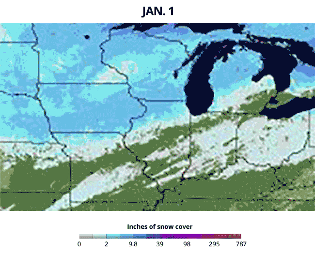
Source: National Weather Service National Operational Hydrologic Remote Sensing Center
2. From atop a building
The views from atop the Field Museum are stunning any time of year, looking across the lake or back toward the skyline. EarthCam’s webcam on top of the museum was an excellent perch to watch the snow come, and later go.
.graphics-head{
font-family:Arial;
font-size:24px;
font-weight:bold;
margin:0px 0px 10px 0px;
}
.graphics-chatter{
font-family:Arial;
font-size:16px;
margin:0px 0px 10px 0px;
}
.graphics-source{
font-family:Arial;
font-size:12px;
margin:0px 0px 10px 0px;
}
.graphics-image{
max-width:650px;
width:100%;
margin-bottom:10px;
}
.embed-container {position: relative; padding-bottom: 77%; height: 0; max-width: 100%;}
.embed-container iframe, .embed-container object, .embed-container iframe{position: absolute; top: 0; left: 0; width: 100%; height: 100%;} small{position: absolute; z-index: 40; bottom: 0; margin-bottom: -15px;}
Timelapse from Field Museum based webcam

Source: EarthCam
3. Using data
One of the more notable aspects of the burst of winter weather in February was the combination of snow and cold temperatures that left deep snow on the ground for an extended time. The chart below shows the buildup and meltdown of the snow at O’Hare. Ten or more inches of snow blanketed the ground at O’Hare for 25 days — the fourth longest stretch in Chicago’s recorded history.
!function(){“use strict”;window.addEventListener(“message”,(function(a){if(void 0!==a.data[“datawrapper-height”])for(var e in a.data[“datawrapper-height”]){var t=document.getElementById(“datawrapper-chart-“+e)||document.querySelector(“iframe[src*='”+e+”‘]”);t&&(t.style.height=a.data[“datawrapper-height”][e]+”px”)}}))}();
4. On the ground with garbage
One of the joys of Chicago winter is to observe what is revealed in drifts as the melt happens. Keen-eyed Twitter observers captured this well, as one might expect.
Time Out Chicago captured this phenomena perfectly with its list of found items.
Sources: National Weather Service, EarthCam, Chicago Tribune reporting.


