Fort Lauderdale a Brief History (100 Years)
•
1 like•1,069 views

A brief history of Fort Lauderdale, Florida made for the 100 year anniversary.

Recommended
More Related Content
Similar to Fort Lauderdale a Brief History (100 Years)
Similar to Fort Lauderdale a Brief History (100 Years) (20)
More from Starmark
More from Starmark (20)
Recently uploaded
Recently uploaded (20)
Fort Lauderdale a Brief History (100 Years)
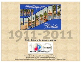
- 1. 1911-2011 A Brief History of the Venice of America Presented by the Fort Lauderdale Centennial Speaker’s Bureau Images courtesy the Fort Lauderdale Historical Society & Broward County Historical Commission & Fort Lauderdale Woman’s Club & SW FL Museum of History
- 2. 1880s Tequesta and their ancestors here for thousands of years. First European settlers in the late 18th C. New River
- 3. 1838 First “fort” founded in 1838 by William Lauderdale after Seminoles killed family of William Cooley 1836 (Now Cooley’s Landing). Drawing of third and most permanent fort.
- 4. 1876 House of Refuge built. In 1890s relocated to site of south beach. Later became Coast Guard. Party at House of Refuge 1911
- 5. 1893 Ferry across New River and Stranahan’s camp and trading post. Pioneers lived along the river.
- 6. 1893 Ferry across New River and Stranahan’s camp and trading post. Pioneers lived along the river.
- 7. 1893 Ferry across New River and Stranahan’s camp and trading post. Pioneers lived along the river.
- 8. 1896 First through FEC train arrives April 1896. African American pioneers work on FEC RR. Stranahan’s camp, 1890s
- 9. 1899 First school 1899 and first school teacher Ivy Cromartie (Stranahan)
- 10. 1902 Seminoles in area since before 1800; had many camps along New River, and North fork by 1902 near I-95 & Broward. Ceremonial grounds were at Pine Island.
- 11. 1902 Marshall Packinghouse south fork New River ca. 1902-1910 Fort Lauderdale was on“high ground” good for farming
- 12. 1905 King’s boatworks just west of Andrews bridge.
- 13. 1905 New River Inn built just west of FEC tracks.
- 14. 1906 Map looking west showing New River, Bay Mable (Port E), farms and citrus groves, planned NNR Canal and the shrinking Everglades 1906 Arrow points to eastern extent of “Everglades” — about I-95
- 15. 1906 Everglades drainage project—began with North New River Canal off the South Fork of New River 1906-1912. Celebration of completion of North New River Canal 1912
- 16. 1908 Where rail and river met was new center of town. Fort Lauderdale became “The Gateway to the Everglades.” View from FEC RR bridge of vegetable docks at foot of Brickell Avenue. Today this is the south end of Las Olas Riverfront. This was the heart of town.
- 17. 1908 Close up of docks by FEC bridge New River ca. 1906-1908
- 18. 1909 “Winter Vegetable Shipping Capital of the South”/ “The Gateway to the Everglades”. Over 100,000 crates of vegetables shipped in 1909
- 19. 1910 Looking SW at New River and Andrews Berryhill-Cromartie at left
- 20. 1910 Andrews look N, late 1910s city hall and fire station at center—at intersection of what is now SW 2nd ST and Andrews
- 21. 1910 Farmers grew just about everything, largest cash crop here was tomatoes (“pines,” peppers, eggplants; beans big in Pompano).
- 22. 1911 Jan 1911, Board of Trade asked that ladies form the Women’s Civic Improvement Assn. Woman’s Club formed before town for “civic improvements”
- 23. Drained Everglades land in great demand
- 24. 1911 Land sale March-April 1911. Thousands of people in a town of 200-300 residents prompted Fort Lauderdale to incorporate March 1911. $240 ($5616 in 2011 $$) entitled you to a lot in Progresso (now Croissant Park) and a “farm” in the Everglades of indeterminate size (about 10 acres) and location. According to Thomas E. Watson in the Jeffersonian Magazine, “land increased in value during the past two years from $2.50 an acre to $2500 an acre for a lot in town.”
- 25. 1911 Population 1910 census: 143 (Probably 200-300 residents) People pouring into Fort Lauderdale (3000-5000) for drained Everglades land resulted in incorporation March 27,1911: 45 registered voters Most important reason: sanitation!!
- 26. 1911 Beautiful downtown Fort Lauderdale 1911 (Brickell) looking N.
- 27. 1911 Inside Everglades Grocery (#1 from previous slide)
- 28. 1911 Berryhill Cromartie store next to Andrews AV bridge
- 29. 1911 Berryhill Cromartie store next to Andrews AV bridge Andrews bridge look N.
- 30. 1911 July 4th party off for the beach 1911. New River Inn circled.
- 31. 1910-1915 “Mass Transit” 1910 Ice/Electric plant 1912 Phones 1914 “Mass Transit” 1915
- 32. 1912 North New River Canal lock #1 (I 595 and Davie Road) New town of Zona (Davie) created 1912 from drained land 20,000 farms sold “west of Fort Lauderdale” by 1910 according to the Homeseeker
- 33. 1912 Days catch Group at beach
- 34. 1912 Fire of 1912 looking NE from RR bridge. Note Fort Lauderdale Sentinel Building at Andrews and SE 2nd ST (near where main library is today)
- 35. 1913 The city rebuilds—looking SW along Brickell Avenue. Note the Osceola Inn at center, which would burn to the ground in July of 1913. The corner of the New River Inn can be seen at far right.
- 36. 1913 East Las Olas about SE3rd ST Stranahan House about 1913 look NE ca. 1915 after renovations. This was probably the easternmost residence except for the Las Olas Inn.
- 37. 1913 Las Olas at Colee Hammock before causeway to the beach
- 38. 1913 Fort Lauderdale home town team (later the Tarpons)
- 39. 1913 Flying Ls before they were known as Flying Ls
- 40. 1913 Flying Ls before they were known as Flying Ls Sunday School camping trip ca 1913-14
- 41. 1914 Fort Lauderdale’s (white) school was located on Andrews at about SW 5th Street. Af Am students attended a school at NW4th Street and NW4 Avenue. (No known photos)
- 42. 1915 On road to Fort Lauderdale Dixie Hwy finished through Broward 1915 Broward Became County 1915
- 43. 1917 Womens Club Clubhouse built at Broward & Andrews (Now being restored)
- 44. 1920s The beach finally became important as an attraction. Dredging Las Olas Isles begins ca 1919. Boom of the 1920s Real estate and tourism replaced farming as focus
- 45. 1926 Downtown Fort Lauderdale. Andrews replaced Brickell as main street.
- 46. 1926 Boom went bust in 1926. Sept 1926 Hurricane damage looking south on Andrews.
- 47. 1928 Casino pool opens. Collegiate Swim Forum shown (1936).
- 48. 1928 Port Everglades opened.
- 49. 1934 Casino Pool Coast Guard Base 6 (Future (Future Bahia Mar) Swimming Hall of Fame)
- 50. 1935 Depression: Fort Lauderdale perseveres... Williams McWilliams Ice Cream T.S. Cobbs, Beddorest Company
- 51. 1945 WWII Naval Air Station
- 52. 1945 Now FLL Airport WWII Naval Air Station
- 53. 1945 Now FLL Airport George H.W. Bush pilot here. Origin of Flight 19 Dec 5, 1945 WWII Naval Air Station
- 54. 1945 War ends; Veterans bring their families back to South Florida to live.
- 55. 1947 More hurricanes? Flood of 1947
- 56. Andrews Avenue looking S late 1940s. Beach late 1940s. Lauderdale Beach Hotel at left.
- 57. 1949 Bahia Mar created from Coast Guard Base 6—a boon to the marine industries. Opened 12/1949.
- 58. 1950s One of many boat parades ca. mid 1950s…
- 59. 1950s Air conditioning & new pest control techniques forever change SoFL Provident hospital Mosquito ditches
- 60. 1953 Civil Defense the buzz word for the era. Television comes to SoFL WTVJ March 1949. Photo 1953.
- 61. 1960 The annual college invasion documented in Where the Boys Are – premiered 12/1960
- 62. 1961 Next Spring 50,000 students invaded.
- 63. 1961 Beach wade-ins
- 64. 1985 As many as 300,000 students by 1985. “The Wall” 1986.
- 65. 1960 Tunnel construction completed Condos appeared everywhere
- 66. 1960s Fort Lauderdale became a well known tennis center—Evert family 1960s. ISHOF construction 1965 (Behind Casino Pool).
- 67. 1972 In 1960s Fort Lauderdale grew 75% –fastest growing city in the state. 1970s—the growth of Broward County too. I-95 looking south at Davie Blvd intersection 1972 (BCHC)
- 68. 2010 Stranahan House 1913
- 69. 2010 Stranahan House 1913 and 2010