South-west Tanami Desert - Department of Natural Resources ...
South-west Tanami Desert - Department of Natural Resources ...
South-west Tanami Desert - Department of Natural Resources ...

You also want an ePaper? Increase the reach of your titles
YUMPU automatically turns print PDFs into web optimized ePapers that Google loves.
<strong>South</strong>-<strong>west</strong> <strong>Tanami</strong> <strong>Desert</strong><br />
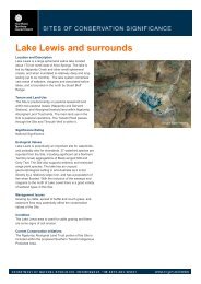
Location and Description<br />
The south-<strong>west</strong> <strong>Tanami</strong> <strong>Desert</strong> is characterised by a<br />
complex mosaic <strong>of</strong> landforms and habitats that are<br />
distinct from the surrounding country. The Site is 440 km<br />
north-<strong>west</strong> <strong>of</strong> Alice Springs, adjacent to the Western<br />
Australian border. It encompasses much <strong>of</strong> the<br />
extensive Central <strong>Tanami</strong> <strong>Desert</strong> paleodrainage system.<br />
Other habitats within the Site include alluvial plains,<br />
dunefields, sandplains, rocky hills and rises, freshwater<br />
and saline lakes, and claypans. This habitat diversity<br />
contributes to a rich flora and fauna and the persistence<br />
<strong>of</strong> many threatened species. Vegetation is varied and<br />
includes hummock grasslands, sparse shrublands and<br />
open woodland.<br />
Tenure and Land Use<br />
The Site is entirely Aboriginal freehold land held by five<br />
Aboriginal land trusts (Central <strong>Desert</strong>, Mangkururrpa,<br />
Yiningarra, Lake Mackay and Mt Frederick). The main<br />
land uses within the Site are Indigenous use, pastoral<br />
operations, and mining. Granites Goldmine and a number<br />
<strong>of</strong> smaller satellite mines are operating within the Site. The<br />
<strong>Tanami</strong> Road passes through the Site and Rabbit Flat<br />
Roadhouse is within it. The site sits within the proposed<br />
<strong>South</strong>ern <strong>Tanami</strong> Indigenous Protected Area.<br />
Significance Rating<br />
International Significance<br />
Ecological Values<br />
The <strong>South</strong>-<strong>west</strong> <strong>Tanami</strong> <strong>Desert</strong> provides habitat for 11<br />
threatened species. It supports populations <strong>of</strong> Bilby,<br />
Brush-tailed Mulgara, Australian Bustard and Great <strong>Desert</strong><br />
Skink, and is considered a stronghold for these and other<br />
rare or declining species in the Northern Territory.<br />
Ephemeral wetlands within the Site support the vulnerable<br />
dwarf desert spike-rush. One plant species is known only<br />
from the Site and other species endemic either to the<br />
<strong>Tanami</strong> bioregion or to the Northern Territory are also<br />
found at the Site.<br />
Management Issues<br />
Major management issues within the Site include feral cat<br />
and fox, which prey on native wildlife, and fire. Mining and<br />
exploration activities are occurring within the Site and road<br />
works and other associated infrastructure may impact<br />
sensitive habitats.<br />
Condition<br />
Condition varies widely across the Site depending on the<br />
relative impacts <strong>of</strong> the factors listed above.<br />
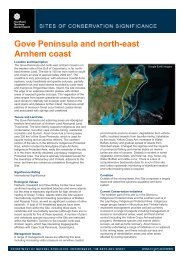
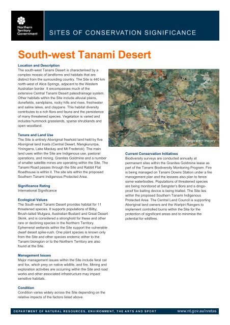
Google Earth imagery<br />
Current Conservation Initiatives<br />
Biodiversity surveys are conducted annually at<br />
permanent sites within the Granites Goldmine lease as<br />
part <strong>of</strong> the <strong>Tanami</strong> Biodiversity Monitoring Program. Fire<br />
is being managed on <strong>Tanami</strong> Downs Station under a fire<br />
management plan and the lessees also plan to fence<br />
some waterbodies. Populations <strong>of</strong> threatened species<br />
are being monitored at Sangster’s Bore and a dingopro<strong>of</strong><br />
fox baiting device is being trialled. The Site lies<br />
within the proposed <strong>South</strong>ern <strong>Tanami</strong> Indigenous<br />
Protected Area. The Central Land Council is supporting<br />
Aboriginal land owners and the Warlpiri Rangers to<br />
implement controlled burns within the Site for the<br />
protection <strong>of</strong> significant areas and to minimise the<br />
potential for wildfires.
SOUTH-WEST TANAMI DESERT - SITE OF CONSERVATION SIGNIFICANCE<br />
<strong>Department</strong> <strong>of</strong> <strong>Natural</strong> <strong>Resources</strong>, Environment, The Arts and Sport 269
LOCATION<br />
THREATENED SPECIES<br />
ENDEMIC SPECIES<br />
WILDLIFE<br />
AGGREGATION<br />
S<br />
SOUTH-WEST TANAMI DESERT - SITE OF CONSERVATION SIGNIFICANCE<br />
SOCS Number 43 (NT Parks and Conservation Masterplan Map Number 66)<br />
Latitude/Longitude 20 º 37´ <strong>South</strong>, 129 º 51´ East (at centre)<br />
Bioregion <strong>Tanami</strong> (98%), Great Sandy <strong>Desert</strong> (2%)<br />
Description The boundary <strong>of</strong> this site is delineated based on seven Sites <strong>of</strong> Botanical Significance identified in White<br />
et al. (2000). These sites are aggregated and extended to include threatened species habitat. A 2 km<br />
buffer is applied to the site and it encompasses an area <strong>of</strong> 19443 km².<br />
Major vegetation communities within the site include s<strong>of</strong>t spinifex Triodia pungens and feathertop spinifex<br />
T. schinzii hummock grassland with acacia tall sparse-shrubland overstorey between dunes; snappy gum<br />
Eucalyptus brevifolia low open-woodland with s<strong>of</strong>t spinifex understorey; and neverfail Eragrostis<br />
xerophila open-grassland with scattered trees and shrubs (White et al. 2000).<br />
Vegetation at some wetland areas includes coolabah and bluebush at swamps, and bare pans <strong>of</strong><br />
ephemeral lakes containing Ruppia sp. fringed by Melaleuca glomerata, or samphire and Acacia<br />
maconochieana fringing bare pans (Duguid 2005).<br />
Significance Rating International Significance<br />
Threatened plants<br />
and animals<br />
(Listings at<br />
National/NT level<br />
CR - Critically<br />
Endangered,<br />
EN - Endangered,<br />
VU - Vulnerable,<br />
NT - Near<br />
Threatened,<br />
LC - Least Concern,<br />
DD - Data Deficient)<br />
Significance Rating Regional Significance<br />
11 threatened species are recently reported from this site.<br />
Plants<br />
Dwarf desert spike-rush Eleocharis papillosa (VU/VU)<br />
Vertebrates<br />
Australian Bustard Ardeotis australis (-/VU)<br />
Australian Painted Snipe Rostratula australis (VU/VU)<br />
Emu Dromaius novaehollandiae (-/VU)<br />
Masked Owl Tyto novauhollandiae (EN/EN)<br />
Princess Parrot Polytelis alexandrae (VU/VU)<br />
Red Goshawk Erythrotriorchis radiatus (VU/VU)<br />
Brush-tailed Mulgara Dasycercus blythi (VU/VU)<br />
Bilby Macrotis lagotis (VU/VU)<br />
<strong>South</strong>ern Marsupial Mole Notoryctes typhlops (EN/VU)<br />
Great <strong>Desert</strong> Skink Egernia kintorei (VU/VU)<br />
Eight threatened species recorded for the site are believed to now be locally extinct from the region<br />
(Black-footed Rock Wallaby Petrogale lateralis, Brush-tailed Bettong Bettongia penicillata, Common<br />
Brushtail possum Trichosurus vulpecula vulpecula, Central Rock-rat Zyzomys pedunculatus, Golden<br />
Bandicoot Isoodon auratus, Mala Lagorchestes hirsutus, Red-tailed Phascogale Phascogale calura and<br />
Western Quoll Dasyurus ge<strong>of</strong>froii).<br />
The site also supports populations <strong>of</strong> the Northern Nailtail Wallaby and the Spectacled Hare-wallaby,<br />
both <strong>of</strong> which are listed as near threatened in the NT.<br />
The high concentration <strong>of</strong> threatened species in this site is, at least partially, due to the presence <strong>of</strong> the<br />
<strong>Tanami</strong> Paleodrainage system, the Granites area providing greater habitat variety than the rest <strong>of</strong> the<br />
<strong>Tanami</strong> <strong>Desert</strong> (<strong>South</strong>gate et al. 2006) and the relative absence <strong>of</strong> exotic competitors and predators<br />
(Morton et al. 1995).<br />
Notes Endemic to the site: One plant species (Marsilea latzii) is entirely restricted to this site and another<br />
(Spermacoce resinosula) is known only from the site and a record immediately adjacent to it.<br />
Endemic to the bioregion: Three plant species recorded from this site are endemic to the <strong>Tanami</strong><br />
bioregion (Coleocoma centaurea, Marsilea latzii and Spermacoce resinosula).<br />
Endemic to the NT: Seven plant species recorded from this site are endemic to the NT (Acacia<br />
abbreviate, Bonamia deserticola, Eleocharis papillosa, Goodenia halophila, Marsilea latzii, Spermacoce<br />
resinosula and Trachymene inflata).<br />
Other: Seven plant species are restricted to the <strong>Tanami</strong> bioregion within the NT but also occur in other<br />
states (Acacia sabulosa, Acacia stellaticeps, Acacia synchronicia, Coleocoma centaurea, Corynotheca<br />
asperata, Indig<strong>of</strong>era ammobia and Pityrodia chorisepala).<br />
Significance Rating Not Significant<br />
Marine turtles Not applicable<br />
Seabirds None known<br />
Waterbirds None known<br />
Shorebirds None known<br />
Other aggregations None known<br />
<strong>Department</strong> <strong>of</strong> <strong>Natural</strong> <strong>Resources</strong>, Environment, The Arts and Sport 270
WETLANDS<br />
FLORA<br />
OTHER ENVIRONMENTAL VALUES<br />
MANAGEMENT<br />
ISSUES<br />
SOUTH-WEST TANAMI DESERT - SITE OF CONSERVATION SIGNIFICANCE<br />
Significance Rating Regional Significance<br />
Ramsar criteria met Not assessed<br />
DIWA criteria met Not assessed<br />
Notes The site encompasses ephemeral wetlands such as Lake Ruth and Sanctuary Swamp, which are filled<br />
by run<strong>of</strong>f from surrounding rises, and the <strong>Tanami</strong> paleodrainage system runs for some 50 km under the<br />
sandplain (Morton et al. 1995).<br />
Buffalo and Bullocks Head Lakes, Kilpatrick Swamp and Sanctuary Swamp occur within the site. It is<br />
thought that the lakes fill fairly regularly, Kilpatrick Swamp fills fairly infrequently, and Sanctuary Swamp<br />
is estimated to be filled every 5 years or so (Duguid 2005). Inundation can be quite long-lasting (>1 year)<br />
(A. Duguid, NRETAS, pers. comm.).<br />
Rivers No information located<br />
Significance Rating Regional Significance<br />
Notes Restricted range species: 15 plants reported from the site have restricted ranges within the NT (Acacia<br />
pachycarpa, Acacia wiseana, Bonamia alatisemina, Dampiera candicans, Eriachne flaccida, Eucalyptus<br />
cupularis, Glycine pullenii, Neobassia astrocarpa, Ptilotus calostachyus var. procerus, Sclerolaena<br />
muelleri, Sesbania cannabina var. sericea, Swainsona tanamiensis, Trianthema glossostigma,<br />
Trianthema turgidifolia and Triodia salina).<br />
Other: The site includes the healthiest (i.e. good recruitment and less fire impacted), and possibly the<br />
largest stands <strong>of</strong> Acacia maconochieana (D. Albrecht and P. Latz, NRETAS, pers. comm.).<br />
The higher reliability <strong>of</strong> water resources occurring in the paleodrainage system and run-on areas<br />
underlying the site result in habitats with relatively continuous production. Native mammalian herbivores<br />
and many invertebrate herbivores are <strong>of</strong>ten most abundant and diverse in such places (Morton 1990).<br />
The <strong>Tanami</strong> Drainage System is identified as a highly significant refuge ecological refuge by Morton et al.<br />
(1995).<br />
<strong>South</strong>gate et al. (2006) found that areas like the <strong>South</strong>-<strong>west</strong> <strong>Tanami</strong>, with a variety <strong>of</strong> substrates or<br />
topographies, provide more reliability <strong>of</strong> resources and protection from some forms <strong>of</strong> disturbance, and<br />
act as significant points <strong>of</strong> refugia and for species radiation. This variety also increases the probability <strong>of</strong><br />
a small-scale mosaic pattern <strong>of</strong> burning.<br />
The former <strong>Tanami</strong> Wildlife Sanctuary and West <strong>Tanami</strong> Area are listed on the Register <strong>of</strong> the National<br />
Estate for their natural values (Australian Heritage Council).<br />
Sanctuary Swamp is identified as being significant for biodiversity conservation by Duguid et al. (2005).<br />
Seven sites <strong>of</strong> Botanical Significance (Mongrel Downs, Bluebush Hills, Western <strong>Tanami</strong> Paleodrainage<br />
Systems, Dead Bullock Soak, Lake White, <strong>Tanami</strong> Paleodrainage system extension and the <strong>Tanami</strong><br />
Range) identified in White et al. (2000), mostly occur within the boundaries <strong>of</strong> this site.<br />
This site does not support regular aggregations <strong>of</strong> waterbirds, however the wetlands provide important<br />
habitat and refuge for numerous waterbirds when inundated. Thirty one species <strong>of</strong> waterbird, 12<br />
shorebird species and two seabird species are recorded for the site.<br />
There are 21 migratory species recorded for this site that are listed under international conventions or<br />
bilateral agreements protecting migratory animals.<br />
The site lies within the proposed <strong>South</strong>ern <strong>Tanami</strong> Indigenous Protected Area.<br />
Fire: In the period 1997-2005, most parts <strong>of</strong> the site (76%) were burnt fewer than two times and none <strong>of</strong><br />
the site was burnt more than four times. The fire regime in the site has changed and there are now more<br />
frequent uncontrolled summer wildfires, which may be affecting threatened species such as the Greater<br />
Bilby (Pavey 2006) and the Great <strong>Desert</strong> Skink (McAlpin 2001).<br />
Feral animals: Cat and fox occur within the site and prey on native wildlife such as the Greater Bilby.<br />
Rabbit and camel also occur within the site.<br />
Weeds and invasive exotic plants: Mossman River Grass Cenchrus echinatus (category B weed),<br />
buffel grass Cenchrus ciliaris and Cyperus involucratus occur within the site. Couch grass Cynodon<br />
dactylon is also likely to be present and spreading.<br />
Other: Mining and exploration activities occur within the site and road works and other associated<br />
infrastructure may have some impacts on sensitive habitats.<br />
<strong>Department</strong> <strong>of</strong> <strong>Natural</strong> <strong>Resources</strong>, Environment, The Arts and Sport 271
MANAGEMENT INFORMATION<br />
KEY REFERENCES<br />
SOUTH-WEST TANAMI DESERT - SITE OF CONSERVATION SIGNIFICANCE<br />
NRM groups Walpiri Rangers.<br />
Protected areas The site lies largely within the proposed <strong>South</strong>ern <strong>Tanami</strong> Indigenous Protected Area (feasibility study<br />
phase).<br />
Current<br />
management plans<br />
Monitoring<br />
programs and<br />
research projects<br />
Management<br />
recommendations<br />
Site-specific plans: <strong>Tanami</strong> Downs Station fire management plan (Paltridge & Latz).<br />
National recovery plans for threatened species: Greater Bilby (Pavey 2006), <strong>South</strong>ern Marsupial<br />
Moles (Benshemesh 2004), Great <strong>Desert</strong> Skink/Tjakura (McAlpin 2001), Brush-tailed Mulgara (SA<br />
<strong>Department</strong> <strong>of</strong> Environment and Heritage in prep.).<br />
Other management plans: Threat Abatement Plan for Predation by the European Red Fox<br />
(Environment Australia 1999); Threat Abatement Plan for Predation by Feral Cats (Environment<br />
Australia, 1999); Australian Weeds Strategy (NRMMC 2007).<br />
Biodiversity surveys are conducted annually at 100 permanent sites within the Granites Goldmine lease<br />
by the Central Land Council and Newmont <strong>Tanami</strong> Pty Limited as part <strong>of</strong> the <strong>Tanami</strong> Biodiversity<br />
Monitoring Program (J. Young pers. comm.). Tree health is also monitored as part <strong>of</strong> the flora surveys in<br />
this program.<br />
Trials <strong>of</strong> a dingo-pro<strong>of</strong> fox baiting device and monitoring <strong>of</strong> threatened species populations are ongoing in<br />
the Sangster’s Bore area. This work is being undertaken by the CLC-supported Warlpiri Ranger Group in<br />
conjunction with consultants and NRETAS Biodiversity Conservation. Predator and threatened species<br />
track counts are conducted along treatment (baited) and control transects. Elliott trapping and random<br />
plot-based tracking surveys are also undertaken as part <strong>of</strong> this work.<br />
The Central Land Council is supporting NRM board Indigenous Ecological Knowledge (IEK) projects in<br />
this area to inform ongoing management under an Indigenous Protected Area.<br />
The Central Land Council is supporting Aboriginal land owners and Warlpiri Rangers to implement<br />
controlled burns for the protection <strong>of</strong> significant areas and for wildfire mitigation (J. Young pers. comm.).<br />
Across the NT, fire is mapped continuously under the North Australia Fire Information Project<br />
http://www.firenorth.org.au/nafi/app/init.jsp<br />
Conduct a survey to identify significant wetlands within the site (NRETA 2005).<br />
Consider management requirements such as fencing to exclude cattle from sensitive areas (NRETA<br />
2005).<br />
Work with the Indigenous rangers and other Traditional Owners to develop appropriate management for<br />
the site. Develop comprehensive vegetation mapping to inform strategic fire management for the<br />
protection <strong>of</strong> threatened species habitats and fire sensitive vegetation communities. Develop an<br />
integrated natural and cultural resource management plan for the area under the <strong>South</strong>ern <strong>Tanami</strong><br />
Indigenous Protected Area (J. Young pers. comm.).<br />
Continue actions to have the site proclaimed an Indigenous Protected Area.<br />
Papers and reports Duguid, A., Barnetson, J., Clifford, B., Pavey, C., Albrecht, D., Risler, J. and McNellie, M. (2005).<br />
Wetlands in the arid Northern Territory. A report to the Australian Government <strong>Department</strong> <strong>of</strong> the<br />
Environment and Heritage on the inventory and significance <strong>of</strong> wetlands in the arid NT. Northern Territory<br />
Government <strong>Department</strong> <strong>of</strong> <strong>Natural</strong> <strong>Resources</strong>, Environment and the Arts. Alice Springs.<br />
Gibson, D.F. (1986) A Biological Survey <strong>of</strong> the <strong>Tanami</strong> <strong>Desert</strong> in the Northern Territory. Conservation<br />
Commission <strong>of</strong> the Northern Territory. Technical report 30. Alice Springs, NT.<br />
White, M., Albrecht, D., Duguid, A., Latz, P. and Hamilton, M. (2000). Plant species and sites <strong>of</strong> botanical<br />
significance in the southern bioregions <strong>of</strong> the Northern Territory; volume 2: significant sites. A report to<br />
the Australian Heritage Commission from the Arid Lands Environment Centre. Alice Springs, NT.<br />
Contributors Theresa Nano, Biodiversity Conservation, NRETAS, Alice Springs.<br />
David Albrecht, Alice Springs Herbarium, NRETAS, Alice Springs<br />
James Young, Central Land Council, Alice Springs.<br />
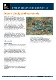
Spinifex country, Sangster’s Bore, <strong>South</strong>-<strong>west</strong> <strong>Tanami</strong> <strong>Desert</strong> (Photo: Jeff Cole)<br />
<strong>Department</strong> <strong>of</strong> <strong>Natural</strong> <strong>Resources</strong>, Environment, The Arts and Sport 272