

Guide to Significant Wildlife Habitat - Door County Web Map
Guide to Significant Wildlife Habitat - Door County Web Map
Guide to Significant Wildlife Habitat - Door County Web Map

Create successful ePaper yourself
Turn your PDF publications into a flip-book with our unique Google optimized e-Paper software.
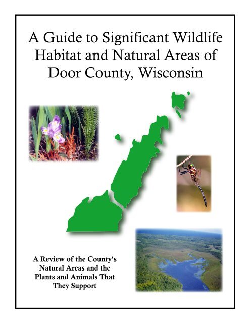
Cover Pho<strong>to</strong>graphs<br />
Top: Dwarf Lake Iris (Iris lacustris) - Courtesy Gary Emmerlich<br />
Middle: Hines Emerald Dragonfly (Soma<strong>to</strong>chlora hineana) - Courtesy Paul Bur<strong>to</strong>n<br />
Bot<strong>to</strong>m: Mink River, on the Upper Peninsula, looking west. - Courtesy Mike Grimm<br />
Cover Design: Pat Robinson, UWEX Lakeshore Basin Educa<strong>to</strong>r for Natural Resources
A <strong>Guide</strong> <strong>to</strong> <strong>Significant</strong> <strong>Wildlife</strong> <strong>Habitat</strong> and Natural Areas<br />
Of<br />
<strong>Door</strong> <strong>County</strong>, Wisconsin<br />
March, 2003<br />
First Edition<br />
A Collaborative Community Project<br />
Copies of this document can be obtained from the<br />
Wisconsin Department of Natural Resources<br />
Sturgeon Bay Service Center<br />
110 S. Neenah Avenue<br />
Sturgeon Bay, WI 54235
Illustrations © 1997 Chris Baird, Minneapolis, All Rights Reserved
– Foreword –<br />
by Nina Leopold Bradley<br />
The Highest and Best Uses of Land<br />
His<strong>to</strong>ry tells us that our native surroundings provide our<br />
fundamental identity and sense of place. They provide the foothold<br />
for understanding who we are as a people. Our natural heritage has<br />
helped <strong>to</strong> shape our cultural heritage.<br />
In <strong>Door</strong> <strong>County</strong> the splendor of its natural surrounding has<br />
played an important role in shaping and nurturing community<br />
values. Fifty years ago Aldo Leopold urged Americans <strong>to</strong> adopt a<br />
more caring attitude <strong>to</strong>ward the land. He wrote, “Quit thinking about<br />
decent land use as solely an economic problem … examine each<br />
question in terms of what is ethically and esthetically right, as well as<br />
what is economically expedient.”<br />
This guidebook on natural areas allows us <strong>to</strong> examine the<br />
maps and descriptions of the uncommon natural wonders that are the<br />
precious heritage of <strong>Door</strong> <strong>County</strong>. Leopold’s thoughts lead us <strong>to</strong><br />
think about what is esthetically right as well as economically<br />
expedient. To achieve a balanced economy, in harmony with the<br />
natural environment and its preservation, will require strong<br />
leadership and a broad ethical vision.<br />
It has been written that the future of our public lands will be determined by the strength of our<br />
leadership on environmental issues. Our own Wisconsin environmental ecologists have articulated such<br />
a commitment over the last century. From Sig Olson <strong>to</strong> Aldo Leopold <strong>to</strong> John Muir, we have abundant<br />
inspiration <strong>to</strong> protect our wildest places, balancing the increasing demand for development.<br />
Conservation, as Aldo Leopold unders<strong>to</strong>od it, is a matter not just of technical skills, but of social<br />
development, which in turn is a matter of changing mores, cus<strong>to</strong>ms, laws, incentives and community<br />
standards.<br />
As we care for this special part of<br />
Wisconsin we may be able <strong>to</strong> implement an<br />
elevation of community standards, a fresh<br />
understanding of the dynamic interrelationship<br />
between public and private interests, and<br />
public and private lands.<br />
Leopold wrote: “Now we face the<br />
question whether a still higher standard of<br />
living is worth its cost in things natural,<br />
wild and free.”<br />
– Foreward – 3
This volume indicates that <strong>Door</strong> <strong>County</strong> still retains some of these “things natural, wild and free”.<br />
Let us value them as we study these carefully constructed maps and descriptions, and consider the highest<br />
and best use of the unspoiled lands.<br />
With all of its appeal, <strong>Door</strong> <strong>County</strong> is going <strong>to</strong> attract growth whether we actively seek it or not.<br />
The future of the county’s remaining undeveloped landscape is contingent upon how we determine their<br />
highest and best use. This guide will facilitate our learning about the county’s remaining natural areas as<br />
we contemplate their future.<br />
4<br />
– Forward –<br />
Nina Leopold Bradley<br />
September, 2002<br />
Aldo Leopold’s eldest daughter Nina Leopold Bradley lives in Baraboo, Wisconsin<br />
where she continues <strong>to</strong> deepen her father’s legacy through her work in<br />
supporting the mission of the Aldo Leopold Foundation.<br />
The Foundation promotes the care of natural<br />
resources by fostering an ethical<br />
relationship between people and land.<br />
Aldo Leopold’s Land Ethic<br />
“When we see land as a community <strong>to</strong> which we belong, we may<br />
begin <strong>to</strong> use it with love and respect. That land is a community is the<br />
basic concept of ecology, but that land is <strong>to</strong> be loved and respected is<br />
an extension of ethics”.
— Preface —<br />
This publication represents the collective efforts of a group of individuals whose intent is <strong>to</strong> help<br />
preserve <strong>Door</strong> <strong>County</strong>’s communities of plants and animals and their habitats. Many people acknowledge<br />
that most of the remaining natural landscapes and open space are seriously threatened by continued<br />
commercial and residential development. Concerned about the problem, this initiative was organized <strong>to</strong><br />
examine this threat and formulate a strategy <strong>to</strong> help minimize the consequences.<br />
One could conclude that the way of life we experience in <strong>Door</strong> <strong>County</strong> is in many respects<br />
dependent upon its open spaces and undeveloped natural landscapes. Considered a special place, <strong>Door</strong><br />
<strong>County</strong> can be characterized by its numerous and diverse natural areas. These places are home <strong>to</strong> a<br />
variety of plant and animal species and geographical features, the likes of which are found nowhere else.<br />
The fact that some of these natural areas are already protected as state parks, nature preserves and<br />
wildlife areas is a testament <strong>to</strong> the high quality of natural ecosystems <strong>to</strong> be found in <strong>Door</strong> <strong>County</strong>. <strong>Door</strong><br />
<strong>County</strong> has a <strong>to</strong>tal of 22 designated State Natural Areas, which is more than any other county. Five state<br />
parks encompassing over 9000 acres are found here, which is also more than in any other county, and two<br />
state wildlife areas contain an additional 3000 acres. The Ridges Sanctuary, The Nature Conservancy,<br />
The <strong>Door</strong> <strong>County</strong> Land Trust and the University of Wisconsin collectively own or manage more than<br />
5000 acres for purposes of natural area protection. Seventeen county parks and numerous <strong>to</strong>wn and<br />
municipal parks provide varying levels of protection for other sites.<br />
Although significant areas of <strong>Door</strong> <strong>County</strong> have been set aside for conservation and recreation,<br />
large expanses of undeveloped natural ecosystems remain unprotected. The rush of daily life makes it<br />
easy <strong>to</strong> take these unprotected areas, and the benefits we derive from them, for granted. Yet many of<br />
these natural landscapes will eventually be lost or degraded if preventive action isn't taken. Losing these<br />
special areas would have a significant and noticeable adverse affect on adjacent properties. Even those<br />
areas that are preserved are threatened by over use or invasive species.<br />
Our purpose has<br />
been <strong>to</strong> provide<br />
practical information<br />
that might assist<br />
citizens and civic and<br />
political leaders in<br />
supporting natural<br />
area preservation and<br />
protection activities in<br />
and around their<br />
communities.<br />
This guide is designed for people at all levels of government.<br />
Hopefully, others will find it useful, including natural resource<br />
professionals and interested citizens. Our purpose has been <strong>to</strong> provide<br />
practical information that might assist citizens and civic and political<br />
leaders in supporting natural area preservation and protection activities in<br />
and around their communities.<br />
Seventeen areas have been identified as the most critical in<br />
maintaining the ecological integrity of <strong>Door</strong> <strong>County</strong>’s natural environment,<br />
and hence one of the keys <strong>to</strong> the county’s way of life. While this list of<br />
areas is certainly not exhaustive and could be debated, it does represent the<br />
best identification effort of a very diverse group of interested parties with<br />
knowledge of <strong>Door</strong> <strong>County</strong> and its natural areas. Each area holds<br />
significant value for recreation, aesthetics, clean air and water, and local<br />
biodiversity.<br />
Even though efforts were made <strong>to</strong> gather information about available land preservation and<br />
protection programs, it has not been included as part of this publication. Future editions will explore and<br />
catalogue the variety of programs and strategies that can be used <strong>to</strong> preserve and protect wildlife habitat<br />
and natural areas.<br />
– Preface – 5
6<br />
— Acknowledgement —<br />
This publication has been an evolving and collaborative effort since its early beginning in July of<br />
1997. The result represents many generously given volunteer hours, numerous regularly scheduled<br />
meetings and considerable give and take by everyone involved. No one individual or organization was in<br />
control, rather the process can best be characterized in the spirit of shared leadership and shared<br />
responsibility. Many of those participating have affiliations with local, state and federal agencies and<br />
conservation organizations but have given of their energies and time as individuals concerned about the<br />
future of wildlife habitat and natural landscapes on the <strong>Door</strong> Peninsula. Their professional association<br />
should not be perceived as an endorsement by those agencies or organizations of the work presented here.<br />
Roy Aiken<br />
Dan Burke<br />
Jaime Corbiser<br />
Ron Fassbender<br />
Coleen Feucht<br />
Robert Florence<br />
Terry Gardon<br />
Mike Grimm<br />
Robert Howe<br />
– Acknowledgements --<br />
Roy Lukes<br />
Patrick Robinson<br />
Bill Ruff<br />
Carl Scholz<br />
William Schuster<br />
Mary Standish<br />
Ron Stieglitz<br />
Joel Trick<br />
Jerry Viste<br />
Others who have occasionally participated <strong>to</strong> offer timely information and advice are recognized<br />
and appreciated for their contribution:<br />
Guenevere Abernathy<br />
David Allen<br />
Jim Bunning<br />
Laddie Chapman<br />
Ray Drake<br />
George Evenson<br />
Mariah Goode<br />
Vinnie Hancock<br />
Bill Laatsch<br />
Arnie Lindauer<br />
Charlotte Lukes<br />
Paul Mahlberg<br />
Robert Merline<br />
Pat Miller<br />
Paul Regnier<br />
Jon Renner<br />
Bob Ryan<br />
Phil Saperstein<br />
Larry Smith<br />
Mike Toneys
Special Recognition<br />
Since its early beginnings these individuals have given many hours <strong>to</strong> this project. Their<br />
agencies, institutions and organizations are each recognized for having allowed them <strong>to</strong> work on this<br />
important project:<br />
Bay Lake Regional Planning Commission<br />
<strong>Door</strong> <strong>County</strong> Environment Council<br />
<strong>Door</strong> Property Owners, Inc.<br />
<strong>Door</strong> <strong>County</strong> Planning Department<br />
<strong>Door</strong> <strong>County</strong> Soil & Water Conservation Department<br />
The <strong>Door</strong> <strong>County</strong> Land Trust<br />
The <strong>Door</strong> <strong>County</strong> Land Use Forum<br />
The Nature Conservancy<br />
United States Fish & <strong>Wildlife</strong> Service<br />
University of Wisconsin-Extension<br />
University of Wisconsin Green Bay<br />
Wisconsin Department of Natural Resources<br />
Bay Lake Regional Planning Commission has provided natural area site maps and the many<br />
seemingly unending revisions as the project unfolded. The Bureau of Endangered Resources of the<br />
Department of Natural Resources has provided considerable assistance in the inven<strong>to</strong>ry of plants and<br />
animals in many parts of the county.<br />
The Wisconsin Department of Natural Resources has been especially helpful in seeking out and<br />
securing the financial resources provided by Peterson Builders, Inc. <strong>to</strong> employ a project coordina<strong>to</strong>r<br />
during the past year <strong>to</strong> pull everything <strong>to</strong>gether for this publication. UW-Extension and the Wisconsin<br />
Department of Natural Resources have helped underwrite printing expenses.<br />
The pen and ink drawings that are found throughout this publication are the works of nature artist<br />
Chris Baird, of Minneapolis MN. Charles Bradley, Sr., husband of Nina Leopold Bradley drew the<br />
sketch of the Leopold Shack shown on page 17.<br />
Richard Follmer piloted his flying machine and allowed us <strong>to</strong> take many of the aerial pho<strong>to</strong>graphs<br />
you’ll see in this guide and his generosity is very much appreciated. Numerous pho<strong>to</strong>graphers are<br />
recognized with credits along side their work and we thank them collectively for their contribution.<br />
A very special thanks <strong>to</strong> Ms. Coleen Feucht, a graduate student at the University of Wisconsin<br />
Green Bay Campus, who has acted as the project coordina<strong>to</strong>r. She has been a tremendous asset in helping<br />
<strong>to</strong> finalize the guide. Serigraph, Inc., of West Bend, Wisconsin generously contributed the printing of the<br />
front and back cover pages. Roy Aiken, coordinated the final revisions, edited, and prepared the<br />
publication for printing.<br />
– Acknowledgements -- 7
— Table of Contents —<br />
Foreword ………………………………………………………………………………………….... 3<br />
Preface ……………………………………………………………………………….………….… 5<br />
Acknowledgement ………………………………………………………………………………… 6<br />
Introduction ……………………………………………………………………………………….. 11<br />
Chapter 1 - A (very) Short Course in Ecology & Related Land Use Philosophy ………………... 15<br />
Chapter 2 - Natural Areas in <strong>Door</strong> <strong>County</strong> ……………………………………………………….. 19<br />
<strong>Wildlife</strong> <strong>Habitat</strong> & Natural Areas Reference <strong>Map</strong> ………………….…………..… 21<br />
Ahnapee River Corridor …………………………………………………………… 23<br />
Black Ash Swamp …………………………………………………………….…… 29<br />
Delwiche – Sand Hill Pineries & Fabry Creek Complex ….………………...……. 33<br />
Renard Swamp ……………………………………………………….……..…….. 39<br />
Hardwood Swamp, Renard Creek, South Renard Swamp,<br />
S<strong>to</strong>ny Creek Wetlands Complex …………………………………………....….…. 45<br />
Brussels Hill / Kayes Creek / Gardner Swamp Complex ……………………….... 51<br />
Hungry Settlement Marsh ……………………………………………………..….. 57<br />
Southern Lake Michigan Shoreline ……………………………………….………. 61<br />
Shivering Sands, Lily Bay, Lily Bay Creek, Kellner Fen<br />
Sturgeon Bay Ship Canal, Clay Banks<br />
Sawyer Harbor / Lost Creek & Larson Creek Watersheds Complex ….……….… 71<br />
West Branch Whitefish Bay Creek Corridor ………………………….….…..…… 77<br />
Whitefish Bay Creek, Marsh Area<br />
Bay Shore Bluff Lands…………………………………………………...….…….. 83<br />
Bay Shore Bluffs & Woods, Spring Lane Hardwood Swamp<br />
Logan Creek / Lost Lake Corridor ………………………………………………… 91<br />
Bay <strong>to</strong> Lake <strong>Wildlife</strong> Corridor ………………………………………….….……… 97<br />
Fish Creek Watershed, Hibbards Creek, Thorp Pond, Meridian Park<br />
North Kangaroo Lake<br />
Ephraim / Baileys Harbor Forest Corridor & North Bay Lowlands ……….…..….. 109<br />
Ephraim Swamp, Forest Corridor, North Bay Three Springs<br />
Mink River / Rowley’s Bay System………………………………………..………. 115<br />
Europe Lake Forest Area ………………………………………….……..………… 123<br />
Grand Traverse Islands ………………………………………….….………….….. 127<br />
Literature Cited …………………………………………………………………………..……….. 149<br />
Glossary of Terms…………………………………………………………………………………. 153<br />
Appendix A – Natural Communities Cross Reference <strong>to</strong> Natural Areas …………………………. 157<br />
Appendix B – <strong>Door</strong> <strong>County</strong>’s Rare Species & Natural Communities ………..…………………… 159<br />
Appendix C – Recognized Natural Communities of <strong>Door</strong> <strong>County</strong>………………………….…….. 171<br />
Appendix D – Natural Areas: A Definition & Status Report……………………………………… 179<br />
Appendix E – Statistics on Wisconsin’s Biological Diversity …………………………………… 195<br />
Appendix F – Resources for Natural Areas Information and Protection …………………………. 197<br />
– Table of Contents – 9
— Introduction —<br />
Natural landscapes and wildlife matter <strong>to</strong> people in Wisconsin and <strong>Door</strong> <strong>County</strong>. Nature and its<br />
seasonal patterns marked by fall colors, the annual migration of waterfowl and songbirds, and the spring<br />
explosion of budding trees and wildflowers are so much a part of people’s everyday lives that we can not<br />
imagine being without them.<br />
But as the pressures of growth and a <strong>to</strong>urism economy accelerate, what will it take <strong>to</strong> protect<br />
these natural resources distributed across the county? Practically speaking, we must consider the<br />
economic aspects. We want communities <strong>to</strong> prosper. Can we afford <strong>to</strong> protect significant parcels of land<br />
and leave them in a wild and natural condition? Our first response is we can't afford not <strong>to</strong>, however,<br />
easy answers or single solutions are not possible. Most likely solutions will have <strong>to</strong> be tailored <strong>to</strong> the<br />
uniqueness of the landscape and the specific needs of each landowner.<br />
Economic vitality may be one of the best reasons for maintaining undeveloped lands in and<br />
around our communities. Natural areas have a positive impact on property values of adjacent lands, and<br />
when kept in their natural or native state serve many practical functions, including moderation of<br />
s<strong>to</strong>rmwater runoff, abatement of surface and groundwater pollution, erosion control and air quality<br />
enhancement. There are many tangible economic benefits that are associated with natural areas. Local<br />
businesses in many communities rely on revenues generated by <strong>to</strong>urism related activities from the public<br />
enjoyment of wildlife, natural areas and open space.<br />
Natural areas improve the overall livability of a community, offering not only quality air and<br />
drinking water, but also scenic beauty and opportunities for low-impact recreation, such as birdwatching,<br />
fishing and hiking, which can be enjoyed by local residents and visi<strong>to</strong>rs alike. Communities with<br />
generous natural areas and open spaces are considered by many as good places for children, and offer a<br />
high quality of life for everyone in the community.<br />
Any serious cost <strong>to</strong> benefit analysis will look beyond the simplistic notion that development<br />
equals an increased tax base, and will tell us that we quite literally can't afford not <strong>to</strong> protect natural areas.<br />
To a great degree, the reason most of us live in or visit <strong>Door</strong> <strong>County</strong> is for the pleasures we derive from<br />
these undeveloped and natural landscapes. If we lose them and the benefits they offer — the quality of<br />
our lives and our children’s lives will have been diminished. Even for those who do not derive direct<br />
pleasures from the enjoyment of natural areas, the local economy is largely dependent upon their<br />
existence, by virtue of the <strong>to</strong>urists that they attract.<br />
The preservation of significant areas of undeveloped landscape can result in a host of benefits <strong>to</strong><br />
the local community. However, some of these are not generally recognized, and others tend <strong>to</strong> be taken<br />
for granted. Below, are some of the advantages of leaving these landscapes in an undeveloped condition.<br />
S<strong>to</strong>rehouse of biological diversity<br />
Among the many things that make <strong>Door</strong> <strong>County</strong> attractive <strong>to</strong> residents and <strong>to</strong>urists alike, are the<br />
widespread natural habitats, and the wildlife they support. It is the high quality of these ecosystems that<br />
make them so appealing, due in large part <strong>to</strong> their high level of ecological integrity. Among the fac<strong>to</strong>rs<br />
contributing <strong>to</strong> <strong>Door</strong> <strong>County</strong>’s unique and rare environments is its location as a major peninsula of the<br />
Lake Michigan coast and the effects of the dolos<strong>to</strong>ne bedrock on surface drainage and water chemistry.<br />
These and other fac<strong>to</strong>rs, combined with relatively low levels of development, help <strong>to</strong> support<br />
habitats for numerous species of rare plants and animals, some of which are found nowhere else in the<br />
state.<br />
– Introduction – 11
As notable as the county is as a site for rare species, it is also recognized for its diversity of more<br />
common and widespread species. The diversity of the local ecosystems is a result of their relatively large<br />
sizes, undisturbed nature, and connections with each other. As landscapes become more developed the<br />
remaining patches of habitat become smaller, more degraded, and less connected with each other. This<br />
lack of connection then prevents many plant and animal species from interacting with other members of<br />
the same species, a process that is essential <strong>to</strong> maintain healthy populations. It also makes it more<br />
difficult for a species <strong>to</strong> re-colonize an area following a local extinction or natural population decline.<br />
Therefore, this connection of habitats is critical <strong>to</strong> retain existing levels of biodiversity in <strong>Door</strong> <strong>County</strong>.<br />
Community's appeal <strong>to</strong> families, new residents and visi<strong>to</strong>rs<br />
The benefits we derive from existing natural areas in the county - green vistas, clean water and<br />
air, abundant wildlife and natural beauty - are among the many reasons for its popularity as a <strong>to</strong>urist<br />
attraction. These are also the very reasons that many people choose <strong>to</strong> live and work in <strong>Door</strong> <strong>County</strong>.<br />
They are a major attractant <strong>to</strong> people wanting <strong>to</strong> purchase or build retirement or vacation homes. As<br />
<strong>to</strong>urism is a primary force in our local economy, the economic vitality of the region depends upon the<br />
attractiveness of our county <strong>to</strong> both visi<strong>to</strong>rs and new residents.<br />
Low-cost s<strong>to</strong>rmwater management and flood control<br />
Natural areas can be highly efficient at moderating the passage of rainfall over the landscape.<br />
They help <strong>to</strong> reduce large pulses of surface waters and slow the passage of water over the land, by<br />
soaking up rainfall and releasing it slowly. Thus, the variety of natural landscapes help <strong>to</strong> prevent erosion<br />
of stream banks and lake shores in developed areas, where streams and rivers tend <strong>to</strong> be more "flashy"<br />
and affected by extreme precipitation events.<br />
Purification system for drinking water and surface waters<br />
A healthy, functioning ecosystem does an excellent job of filtering runoff from snowmelt or<br />
rainfall and removing sediment and pollutants. These free ecological “services” result in cleaner water<br />
being discharged <strong>to</strong> lakes and streams, as well as <strong>to</strong> groundwater.<br />
Contribution <strong>to</strong> air quality<br />
The trees, shrubs and other vegetation of natural areas act as effective and efficient filters of<br />
atmospheric gases, absorbing many airborne pollutants. Living vegetation produces abundant oxygen,<br />
essential <strong>to</strong> all animal life, including humans.<br />
Increased property values<br />
<strong>Door</strong> <strong>County</strong> property values are higher than in many other areas of the state. One reason for this<br />
is the attractiveness of the area due <strong>to</strong> its scenic and natural beauty. There is little doubt that individual<br />
property values are also influenced by the surrounding land use, with greater value given <strong>to</strong> a scenic and<br />
natural landscape. Retaining these special places throughout the county will enhance long-term property<br />
values in <strong>Door</strong> <strong>County</strong>.<br />
Tourism dollars<br />
Natural areas are important wildlife habitat, serving <strong>to</strong> support the hunting and fishing, skiing,<br />
snowmobiling, hiking, biking, birding and boating activities that attract so many visi<strong>to</strong>rs. Even for those<br />
visi<strong>to</strong>rs who do not partake in active recreation, natural areas are important <strong>to</strong> their <strong>Door</strong> <strong>County</strong><br />
experience, providing the rural character and scenic vistas that many people value.<br />
12<br />
– Introduction –
Former Astronaut Kathryn Sullivan, the first woman <strong>to</strong> walk in space, relates with clarity how she<br />
became a citizen of the planet in a recent special issue of Time Magazine. She confesses that as you<br />
circle the planet at intervals of 90 minutes you cannot help but acquire a very different perspective of the<br />
world.<br />
“All the colors and patterns you see – the visible evidence of the complex<br />
working of the natural systems that make our planet habitable – seem both vast<br />
and precise, powerful and yet somehow fragile. You see volcanoes spewing smoke,<br />
hurricanes roiling the oceans and even fine tendrils of Saharan dust reaching<br />
across the Atlantic. You also see the big, gray smudges of fields, paddies and<br />
pastures, and at night you marvel at the lights, like brilliant diamonds, that reveal<br />
a mosaic of cities, roads and coastlines — impressive signs of the hand of<br />
humanity.<br />
Scientists tell us that our hand is heavy, that we are wiping out other species<br />
at an unprecedented rate and probably transforming our climate. Will the<br />
immense power of global systems withstand the impact of humanity? Or is it<br />
possible that our collective actions will change the nature of our planet enough <strong>to</strong><br />
cripple its ability <strong>to</strong> support life?<br />
I no longer believe that we can wait for all the scientific data needed <strong>to</strong><br />
answer these questions conclusively. We must recognize immediately what it<br />
means <strong>to</strong> be citizens for this planet. It means accepting our obligation <strong>to</strong> be<br />
stewards of the earth’s life-giving capacities. As homeowners, we wouldn’t neglect<br />
or damage our houses until they weren’t fit <strong>to</strong> live in. Why would we do that with<br />
our planet?” ©2002 TIME, INC. reprinted by permission.<br />
Kathryn Sullivan, who as a Navy Reserve captain, flew three space shuttle missions<br />
now resides in Columbus Ohio where she is president of the<br />
Center of Science & Industry. (www.cosi.org)<br />
It’s interesting that Aldo Leopold’s vision of stewardship and a land ethic resonate from miles<br />
above the earth. The phrase “think global – act local” offers a perspective from which each of us can be<br />
citizens of the planet as stewards of the natural communities in our neighborhood. Stewardship can take<br />
many forms, from increased local efforts <strong>to</strong> eliminate pollution from streams and creeks, <strong>to</strong> seeing<br />
nature’s landscapes as community assets.<br />
The hope for this publication is that it helps <strong>to</strong> generate increased interest for preserving the<br />
remaining wildlife habitat and natural areas in each of the communities described in the following<br />
seventeen sections. Collaboration among local, state and federal agencies, citizens and landowners will<br />
be essential in developing new and creative methods <strong>to</strong> accomplish what will, at best, be a difficult task.<br />
It is not our purpose <strong>to</strong> identify how or when these places should be protected or who should help<br />
<strong>to</strong> protect them. Many organizations and citizens will need <strong>to</strong> be involved in evaluating more precisely<br />
where protection efforts can best be focused and which preservation or protection strategies are most<br />
appropriate. Successful efforts will most likely depend on the area’s landowners. Their vision of the<br />
future will play a major role in determining if, when and how these places are protected.<br />
– Introduction – 13
A (very) Short Course in Ecology &<br />
Related Land Use Philosophy<br />
Chapter 1<br />
Used with permission<br />
of the Minnesota Department of<br />
Natural Resources & Laurie Allman (1997)<br />
At the root of every discussion and decision related <strong>to</strong> natural area protection are qualitative<br />
judgements.<br />
• What qualities are desirable in a natural area?<br />
• What level and type of impacts resulting from a development, new home or<br />
management practice will be considered acceptable?<br />
• What exactly is one is trying <strong>to</strong> protect?<br />
In any genuine initiative aiming <strong>to</strong> sustain the health of local natural areas, the answers <strong>to</strong><br />
questions such as these must be grounded in the basic principles of ecology.<br />
Ecology is about relationships—relationships among living things, and between living things and<br />
their non-living environment. As a scientific discipline, ecology pays attention <strong>to</strong> how things interact.<br />
This discipline assumes that it is both impractical and misguided <strong>to</strong> look at individual living things in<br />
isolation, because living things depend for their survival on the set of elements that surround them and the<br />
processes that sustain their population over time. It considers natural areas <strong>to</strong> be intricate and interacting<br />
systems that operate at many scales. Ecologists assess the condition of natural areas by looking at three<br />
primary elements: composition, structure, and function.<br />
Composition is a measure of the plant and animal species present, their relative<br />
abundance, and the differing characteristics of individuals that make up populations,<br />
such as age, ability <strong>to</strong> reproduce, and relative vigor.<br />
Structure refers <strong>to</strong> the physical organization of natural elements across a landscape -<br />
that is, awareness of patterns evident in the distribution of living things and how those<br />
patterns change naturally over time. Elements of structure include the varying heights<br />
of vegetation, the degree <strong>to</strong> which a community is open or unshaded, and the mosaic of<br />
natural community types across a defined area, as well as the presence of nonliving<br />
elements such as waterways, rocks, logs and woody debris on the forest floor.<br />
Function refers <strong>to</strong> the processes and relationships that sustain a system. Such as the<br />
flow of nutrients moving through an ecosystem, the natural disturbance regimes that<br />
determine site conditions, such as wind events, fire, seasonal water level changes, and<br />
the movement of animals <strong>to</strong> find food and appropriate sites for breeding and<br />
reproduction. There are many ways that the needs of plants and animals are met<br />
through interactions with each other and with their physical non-living surroundings,<br />
and many roles that each individual or population plays in the operation of the system<br />
as a whole.<br />
A site with ecological integrity contains populations of native species in naturally occurring<br />
patterns as determined by the unique physical characteristics, climate, and his<strong>to</strong>ry of the site. Natural<br />
processes will drive changes and fluctuations in structure and composition over time.<br />
Chapter 1– A Short Course in Ecology 15
16<br />
An ecosystem is a dynamic complex of plant, animal, fungal and<br />
microorganism communities and their associated nonliving environment<br />
interacting as an ecological unit.<br />
An appreciation of the complexity of ecosystems is at the very root of ecology. It is not<br />
uncommon for ecologists who have devoted their lives <strong>to</strong> researching a particular species or natural<br />
process <strong>to</strong> insist that they have only scratched the surface of understanding. Ecologists hold <strong>to</strong> this<br />
position in part because natural systems are ever changing, and in part because our ability <strong>to</strong> get the right<br />
answers is limited by our ability <strong>to</strong> ask the right questions.<br />
Yet the fact that our study of the natural world will always be a work in progress does not mean<br />
that we cannot make decisions based upon what knowledge we have already acquired. Just as the equally<br />
inexact science of medicine is routinely used <strong>to</strong> guide the decisions we make about our health care, we<br />
must actively use the understandings gained by ecological research <strong>to</strong> guide our land use decisions. What<br />
has the study of ecology taught us? A few generally accepted concepts include:<br />
Having a diversity of native species - many different kinds of naturally occurring plants and<br />
animals - tends <strong>to</strong> make an ecosystem more stable and better able <strong>to</strong> handle stress, and may be<br />
used as one of the indica<strong>to</strong>rs of health. It is therefore desirable <strong>to</strong> maintain the biological<br />
diversity that is naturally characteristic of a site, with the understanding that some areas are<br />
naturally lower in diversity, as well as some are naturally higher, as in a rain forest.<br />
Plants and animals do not occur randomly over the landscape; they occur in identifiable and<br />
recurring groupings of species known as "natural communities." Populations that comprise a<br />
community may live in proximity because of interdependent relationships (preda<strong>to</strong>r/prey), or<br />
similar habitat requirements and physical <strong>to</strong>lerances, such as fish species that share a need for<br />
high oxygen waters or insects that require high humidity environments, or plants that can thrive in<br />
dry climates. [Note: For a listing of <strong>Door</strong> <strong>County</strong>’s natural communities see Appendix “A” and<br />
for a description of these areas see Appendix “C”].<br />
Energy moves through natural systems in complex ways, so that each organism plays a role in<br />
determining the conditions for other organisms. For a system <strong>to</strong> be sustained, nutrients must be<br />
transferred from one species <strong>to</strong> another, and dead and decaying materials must be allowed <strong>to</strong><br />
break down or decompose and reenter the system <strong>to</strong> support the development of new life.<br />
There are limits <strong>to</strong> the adaptability of species and ecosystems. Change is inherent in natural<br />
systems and occurs when species expand their range in<strong>to</strong> new terri<strong>to</strong>ries, or when populations<br />
fluctuate in response <strong>to</strong> food availability and climate changes, or when one plant community is<br />
gradually supplanted by another through the process of succession. Accelerated rates of change<br />
can produce conditions that cause populations of species and even entire natural systems <strong>to</strong><br />
collapse. Declines are not always gradual; species may decline <strong>to</strong> critical threshold level and then<br />
crash. Worldwide, 99% of modern-day, post-1600 species extinctions are considered attributable<br />
<strong>to</strong> human activity. (Primack 1995)<br />
Chapter 1– A Short Course in Ecology
Obviously, these are broad concepts, which are not immediately applicable <strong>to</strong> given land use<br />
decisions. Nevertheless, it is with such principles that we can begin <strong>to</strong> build the philosophical foundation<br />
that determines the way in which we approach discussions about land use issues. Strategic ways of<br />
thinking that may reasonably arise from the principles would include:<br />
Assumption of value<br />
The willingness <strong>to</strong> work under the assumption that each element of a natural system has<br />
an important role <strong>to</strong> play in the health of the system, as a whole, even if the specific contribution<br />
of the species is unknown. Accordingly, a threat <strong>to</strong> one component of a system is treated as a<br />
threat <strong>to</strong> the system as a whole.<br />
Thinking system — thinking forever<br />
A shift away from planning and managing for the benefit of a few species and <strong>to</strong>ward<br />
planning and management at an ecosystem level, in which an effort is made <strong>to</strong> preserve the<br />
structure and function of natural communities over the long term.<br />
Erring on the side of caution<br />
Acceptance of a certain degree of humility regarding the limits of our knowledge about<br />
natural areas, and accordingly, the desire <strong>to</strong> err on the side of caution when evaluating whether a<br />
given land use practice will have a negative affect on a species or community. If the structure of<br />
a natural community is unduly compromised, there is a point, at which it can be expected <strong>to</strong> fail,<br />
after which it will no longer serve valued ecological functions, such as water quality enhancement<br />
or habitat for native species.<br />
Protection over res<strong>to</strong>ration<br />
A heightened emphasis on proactive planning <strong>to</strong> protect natural sites rather than an<br />
emphasis on res<strong>to</strong>ration or mitigation, given the understanding that "created" or "built"<br />
environments seldom achieve the same degree of complexity and diversity found in communities<br />
of natural origins and that even modest res<strong>to</strong>ration efforts are extremely costly.<br />
A new aesthetic<br />
A new aesthetic view of natural areas, in which system health and ecological integrity are<br />
assigned greater value than purely scenic or recreational considerations.<br />
Illustration of the Leopold Shack by Charles C. Bradley, Sr., with permission of The Aldo Leopold Foundation<br />
Chapter 1– A Short Course in Ecology 17
<strong>Significant</strong> <strong>Wildlife</strong> <strong>Habitat</strong> & Natural Areas<br />
Chapter 2<br />
The wildlife habitat and natural areas identified in this chapter are arranged beginning in the<br />
southern part of the county and continuing <strong>to</strong> the north. Information pertaining <strong>to</strong> each of the sites has<br />
been organized using the following headings:<br />
Location: The generalized location of the site indicates the area of the county, section and <strong>to</strong>wn<br />
within which the site is located. The area identified on the site map is not precisely defined and is only<br />
intended <strong>to</strong> draw attention <strong>to</strong> the general area that is known <strong>to</strong> contain one or more significant natural<br />
communities.<br />
General Site Description: The site description points out pertinent natural characteristics and<br />
highlight recognizable features in the area. Other information such as the status of land use planning that<br />
applies <strong>to</strong> the entire area may be covered.<br />
Ecological Significance: This section gives more detailed information about the ecological features<br />
of the site that make it worthy of consideration for preservation.<br />
Noteworthy Cultural & His<strong>to</strong>rical Features: Some of the more interesting features of the area’s<br />
his<strong>to</strong>ry and how it has evolved since settlement began are highlighted in this section.<br />
Site Features: Each of the area’s identifiable locations is addressed in greater detail, including plant<br />
and animal species known <strong>to</strong> be in the area. Also covered are natural features such as types of soils,<br />
vegetation, and other attributes, that help <strong>to</strong> identify the area’s contribution as a community asset.<br />
Conservation Goals: Several general conservation goals are listed for each natural area. These goals<br />
are intended <strong>to</strong> provide some broad guidance <strong>to</strong> future conservation efforts. It is important <strong>to</strong> note that the<br />
goals are only representative of what may be appropriate for maintaining the natural characteristics of a<br />
given site.<br />
Threats: The threats identified are not all-inclusive, but rather bring out the general or more obvious<br />
threats <strong>to</strong> the health of the ecosystems and natural communities that exist on the site. Specific strategies<br />
or tactics needed <strong>to</strong> eliminate or minimize these threats are not covered in this publication.<br />
Information Needs & Gaps: Since this is a work in progress, additional research and data collection<br />
needed is listed for some of the sites.<br />
Additional References: In several cases, important reference materials for the site should not be<br />
overlooked, although they are not specifically addressed in the site’s text. These references are listed in<br />
this section.<br />
Site <strong>Map</strong> and Pho<strong>to</strong>s: A map of the general boundary for the project area is shown in green with<br />
adjacent natural areas identified in yellow, or brown for state-owned lands or dark green for private<br />
conservation areas. Pho<strong>to</strong>graphs are included for each site and show some of the dominant features as<br />
well as surrounding habitat you would expect <strong>to</strong> see in the area.<br />
Chapter 2 – <strong>Significant</strong> <strong>Wildlife</strong> <strong>Habitat</strong> and Natural Areas 19
20<br />
Site Index<br />
<strong>Wildlife</strong> <strong>Habitat</strong> & Natural Areas Reference <strong>Map</strong> ……………….……….……….. 21<br />
Ahnapee River Corridor ……………………………………………………….……… 23<br />
Black Ash Swamp ………………………………………………………………….…… 29<br />
Delwiche – Sand Hill Pineries & Fabry Creek Complex…………………....……. 33<br />
Renard Swamp ……………………………………………………….…………..…….. 39<br />
S<strong>to</strong>ny Creek Wetlands Complex ……………………………..……….………..….…. 45<br />
Brussels Hill / Kayes Creek / Gardner Swamp Complex ……………………….... 51<br />
Hungry Settlement Marsh …………………………………………..……………..….. 57<br />
Southern Lake Michigan Shoreline ……………………………………….….……… 61<br />
Sawyer Harbor / Lost Creek & Larson Creek Watersheds Complex ..….….….… 71<br />
West Branch Whitefish Bay Creek Corridor …………………..……………….…… 77<br />
Bay Shore Bluff Lands……………………………………..…………………………... 83<br />
Logan Creek / Lost Lake Corridor .…………………………………………..……… 91<br />
Bay <strong>to</strong> Lake <strong>Wildlife</strong> Corridor ……………………………………………...………… 97<br />
Ephraim / Baileys Harbor Forest Corridor & North Bay Lowlands ……..…….. 109<br />
Mink River / Rowley’s Bay System ……………….…………………….……….…... 115<br />
Europe Lake Forest Area …………………………………………………..………… 123<br />
Grand Traverse Islands ……………………………………………………..….…….. 127<br />
Chapter 2 – <strong>Significant</strong> <strong>Wildlife</strong> <strong>Habitat</strong> and Natural Areas
AHNAPEE RIVER CORRIDOR<br />
LOCATION:<br />
The Ahnapee River Corridor is located in southern <strong>Door</strong> <strong>County</strong> (T25-26N, R24E) in the Towns<br />
of Brussels and Forestville. As this report represents general areas of concern, exact locations of<br />
boundary lines have not been designated.<br />
GENERAL SITE DESCRIPTION:<br />
The Ahnapee River Corridor is approximately 5,200 acres in size. Much of the surrounding land<br />
adjacent <strong>to</strong> the river is composed of woodlots and farmland. Idle land comprises much of the area<br />
categorized as farmland. Therefore, a potential exists <strong>to</strong> purchase lands not currently utilized for<br />
agriculture or residential purposes for ecological res<strong>to</strong>ration. One significant attribute of the Ahnapee<br />
River is the length of its reaches. The longest river trip via canoe in <strong>Door</strong> <strong>County</strong> exists between <strong>County</strong><br />
Road H and the Kewaunee <strong>County</strong> line.<br />
ECOLOGICAL SIGNIFICANCE:<br />
The Ahnapee River Corridor and Kayes Creek/Brussels Hill/Gardner Swamp Complex provide a<br />
continuous habitat passage that stretches from the Kewaunee <strong>County</strong> line north <strong>to</strong> the waters of Green<br />
Bay. The overall length of the Ahnapee River Corridor and the land-water interface provided through its<br />
connection <strong>to</strong> the river and its secondary connection <strong>to</strong> the bay make the corridor an ecologically<br />
significant area for <strong>Door</strong> <strong>County</strong>. Additionally, the river corridor is relatively intact, thereby providing<br />
important habitat for a variety of riparian wildlife.<br />
The Ahnapee River Corridor begins in wetlands north of the river and is a valuable fishing and<br />
boating resource (Zimmerman 1989). The miles of open <strong>to</strong> shrubby wetland habitat and upland woodlots<br />
along the river corridor form a landscape pattern suitable for a large number of bird species. Birds<br />
commonly seen or heard in the moist meadows of grasses, dogwood and green ash south of Forestville<br />
include Sedge Wren (Cis<strong>to</strong>thorus platensis), Swamp Sparrow (Melospiza georgiana), Yellow Warbler<br />
(Dendroica petechia), Sandhill Crane (Grus canadensis), Red-wing Blackbird (Agelaius phoeniceus),<br />
Common Yellowthroat (Geothlypis trichas), and Song Sparrow (Melospiza melodia). The adjoining<br />
upland woodlots and fields contain Northern Cardinal (Cardinalis cardinalis), American Redstart<br />
(Se<strong>to</strong>phaga ruticilla), Eastern Meadowlark (Sturnella magna), Brown Thrasher (Toxos<strong>to</strong>ma rufum),<br />
American Robin (Turdus migra<strong>to</strong>riius), Red-eyed Vireo (Vireo olivaceus), Gray Catbird (Dumetella<br />
carolinensis), and House Wren (Troglodytes aedon). This north-south tending corridor of natural lands<br />
probably also serves as an important spring and fall migration corridor for passerine songbirds.<br />
NOTEWORTHY CULTURAL AND HISTORICAL FEATURES:<br />
The Ahnapee River, formerly known as the Wolf, played a major role in the settlement of the area<br />
and particularly the <strong>to</strong>wn of Forestville, which was the third <strong>to</strong>wn <strong>to</strong> be organized (1857) in the county.<br />
Mainly people of Irish and German descent settled the area. The Ahnapee was at one time a deep river<br />
and for more than 20 years steamboats and heavily laden barges navigated its waters (Holand 1917). In<br />
later years after much of the surrounding land had been cleared, the river became <strong>to</strong>o shallow for<br />
commercial use. The river drains much of the southern portion of the county and sedimentation resulting<br />
from timber harvesting, land clearing and the fire of 1871 were contributing fac<strong>to</strong>rs leading <strong>to</strong> its loss of<br />
depth.<br />
The Ahnapee River State Recreation Trail is one of the oldest segments of the Ice Age Trail in<br />
Wisconsin and is excellent for hiking, biking, snowmobiling, and horse back riding. The 28-mile long<br />
trail starts at the ship canal in the City of Sturgeon Bay and heads south through <strong>Door</strong> <strong>County</strong> and<br />
eventually ends in Kewaunee <strong>County</strong>. Visi<strong>to</strong>rs can view a combination of farmland and natural areas<br />
ranging from cedar swamps <strong>to</strong> hardwood forests. The marshes along the Ahnapee River offer excellent<br />
viewing opportunities for many waterfowl, mammals, and annual salmon spawning runs (WDNR 2000).<br />
Ahnapee River Corridor 23
SITE FEATURES:<br />
Ahnapee River Corridor<br />
The portion of the Ahnapee River within <strong>Door</strong> <strong>County</strong> is 8.5 miles in length and averages 25 feet<br />
in width, with a low gradient of 7.7 feet per mile. The headwaters of the Ahnapee lie north of Highway 42<br />
near Tornado Memorial <strong>County</strong> Park. A major tributary, Silver Creek, joins the Ahnapee just south of the<br />
highway. The river eventually empties in<strong>to</strong> Lake Michigan within the City of Algoma.<br />
• The Town of Brussels recently adopted a <strong>to</strong>wn-zoning ordinance and in 2002 was in the public<br />
hearing phase for implementing a comprehensive land use plan. The plan is expected <strong>to</strong> be complete<br />
early in 2003. The Town of Forestville has not adopted a county or <strong>to</strong>wn-zoning ordinance although<br />
numerous discussions regarding ordinances have taken place over the past few years.<br />
• In the Town of Brussels land use surrounding the Ahnapee River Corridor is predominantly woodland<br />
with lesser amounts of cropland, idle farmland, natural lands, recreational area, and residential lots.<br />
In the Town of Forestville land use near the river corridor consists of cropland with lesser amounts of<br />
idle farmland, recreational public, and non-farm residential.<br />
• Soils are deep, well drained <strong>to</strong> poorly drained, and level <strong>to</strong> sloping. Loamy sand <strong>to</strong> silt loam subsoil<br />
overlays sandy loam or loam till (USDA SCS 1978).<br />
• A county dam impounds the river in Forestville forming the Forestville Millpond. The river is<br />
adversely impacted by non-point source pollution from local agriculture practices and overall, the<br />
river receives only a fair quality ranking. The Ahnapee River is listed for PCB contamination, and as<br />
recently as 2000 there was an advisory on smallmouth bass and carp consumption (Corbisier 2000).<br />
• Pre-settlement vegetation of the Ahnapee River Corridor was predominantly of two types; upland<br />
areas dominated by a northern mesic forest composed of maple (Acer spp.), hemlock (Tsuga<br />
canadensis), and yellow birch (Betula allgheniensis); and lowland forests dominated by swamps of<br />
black spruce (Picea mariana), tamarack (Larix laricina), and cedar (Thuja occidentalis) (Finley<br />
1976).<br />
• Trout and salmon are s<strong>to</strong>cked annually, and the river sustains annual fish runs in spring and fall below<br />
the dam (Corbisier 2000).<br />
• Osprey (Pandion haliaetus), a fish-eating rap<strong>to</strong>r, is a state-threatened species known <strong>to</strong> use this<br />
stream corridor.<br />
CONSERVATION GOALS:<br />
• Maintain ecological integrity of the Ahnapee Rive Corridor, including associated upland forest habitat<br />
and wetlands.<br />
• Enhance and protect the water quality of river and its tributaries.<br />
• Maintain large blocks of undisturbed habitat <strong>to</strong> promote natural interactions among plant and animal<br />
communities.<br />
24<br />
Ahnapee River Corridor
THREATS:<br />
• Non-point source pollution from agricultural practices is degrading stream quality.<br />
• Increasing development pressure is a threat <strong>to</strong> both the Ahnapee River floodplain and the relatively<br />
contiguous habitat corridor that surrounds the Ahnapee River.<br />
• The proposed four-lane expansion of Highway 42-57 will have a serious impact on this watershed and<br />
many of the source streams will be entirely relocated at the crossings.<br />
INFORMATION NEEDS / GAPS:<br />
• Vegetation and animal inven<strong>to</strong>ries<br />
• Names of supportive groups and individuals in this site<br />
Ahnapee River Corridor 25
26<br />
Ahnapee River Corridor
OAD<br />
ROAD<br />
END<br />
DEAD<br />
ROOSEVELT<br />
MP<br />
RD.<br />
ROAD<br />
RD.<br />
ROOSEVELT<br />
ROAD<br />
SCHOOL<br />
ROAD<br />
Rosiere<br />
RIDGE<br />
HILLY<br />
ROAD<br />
ROAD<br />
SWAMP<br />
RD.<br />
MISERE<br />
Kayes<br />
LANE<br />
Brussels Hill/Kayes Creek/<br />
Gardner Swamp Complex<br />
ROAD<br />
SWAMP COURT<br />
B R U S S E L S<br />
<strong>Door</strong><br />
<strong>County</strong><br />
GARDNER<br />
#<br />
ROAD E.<br />
NASEWAUPEE<br />
UNION BRUSSELS FORESTVILLE<br />
Forestville<br />
HIGH<br />
EGG<br />
HARBOR<br />
N.<br />
RD.<br />
TOWN HALL<br />
TOWN HALL RD.<br />
S.<br />
N<br />
2000 0 2000 4000 Feet<br />
BAY<br />
Egg Harbor<br />
SEVASTOPOL<br />
Sturgeon STURGEON<br />
Bay<br />
CLAYBANKS<br />
ROAD<br />
DUMP<br />
LIBERTY<br />
GROVE<br />
GIBRALTAR<br />
BAILEYS<br />
JACKSONPORT<br />
Sister Bay<br />
Ephraim<br />
HARBOR<br />
RABBIT<br />
STAR ROAD<br />
WASHINGTON<br />
Ahnapee River Corridor<br />
ROAD<br />
LANE<br />
CEDAR<br />
E.<br />
<strong>Door</strong> <strong>County</strong>, Wisconsin<br />
TORNADO<br />
RD.<br />
RENIER<br />
FLAT<br />
RD.<br />
KOLBERG<br />
ROAD<br />
K E W A U N E E C O U N T Y<br />
STEVENSON<br />
ROAD<br />
PIER<br />
STEVENSON<br />
RD. Kolberg<br />
ROAD<br />
MARSH<br />
CURVE<br />
RD.<br />
RD.<br />
CURVE<br />
ROAD<br />
Black Ash<br />
Swamp<br />
DRIVE SCHOOL<br />
SCHOOL<br />
LANE<br />
Ahnapee<br />
HERB'S<br />
CLOVERLEAF<br />
RD.<br />
DR.<br />
ELM<br />
FOREST<br />
DRIVE<br />
FOREST<br />
57<br />
Kewaunee <strong>County</strong><br />
River<br />
Ahnapee River Corridor<br />
Adjacent Project Areas<br />
State Owned Lands/Parks<br />
NOTE: Site boundaries are approximate.<br />
STONE<br />
F O R E S T V I L L E<br />
CENTER<br />
NAZE<br />
RD.<br />
CHERRY<br />
Forestville<br />
Flowage<br />
FORESTVILLE<br />
ROAD<br />
MILL<br />
42<br />
FEEST<br />
GAEDE<br />
RD.<br />
<strong>Map</strong>lewood<br />
MILE<br />
LA.<br />
BRANS<br />
RD.<br />
ROAD<br />
S<strong>to</strong>ny Creek<br />
Wetland Complex<br />
ROAD<br />
IDLEWILD<br />
ROAD<br />
OLD KRUEGER<br />
COUNTY<br />
GUILETTE<br />
RD.<br />
RD.<br />
ROA<br />
STOKES<br />
MAPLEWOOD<br />
GEIER<br />
ROAD<br />
LINE<br />
DUFEK<br />
LA.<br />
CARNOT<br />
ROAD<br />
Source: Bay-Lake Regional Planning Commission, 2003.<br />
OLD<br />
ROA
Ahnapee River Corridor<br />
ALL PHOTOS BY COLEEN FEUCHT
BLACK ASH SWAMP<br />
LOCATION:<br />
The Black Ash Swamp, located in the Towns of Brussels and Forestville encompasses<br />
approximately 2100 acres in southeastern <strong>Door</strong> <strong>County</strong> (T25N, R25E). As this report represents general<br />
areas of concern, exact locations of boundary lines have not been designated.<br />
GENERAL SITE DESCRIPTION:<br />
Although the largest portion of the Black Ash Swamp lies in Kewaunee <strong>County</strong>, a significant<br />
section of the swamp is located in <strong>Door</strong> <strong>County</strong>. Within close proximity and directly <strong>to</strong> the north of the<br />
Black Ash Swamp is the Ahnapee River Corridor.<br />
The Town of Brussels recently adopted a <strong>to</strong>wn-zoning ordinance and in 2002 was in the public<br />
hearing phase of implementing a comprehensive land use plan. The plan is expected <strong>to</strong> be complete early<br />
in 2003. The Town of Forestville has not as yet adopted a county or a <strong>to</strong>wn-zoning ordinance although<br />
discussions have continued for the past few years.<br />
ECOLOGICAL SIGNIFICANCE:<br />
The Black Ash Swamp is the largest contiguous forest in southern <strong>Door</strong> <strong>County</strong> (Zimmerman,<br />
1989), and continues in<strong>to</strong> Kewaunee <strong>County</strong> where it forms, by far, the largest block of forested land in<br />
Kewaunee <strong>County</strong>. The swamp covers approximately 5000 acres in <strong>to</strong>tal and 2100 acres in <strong>Door</strong> <strong>County</strong>.<br />
This 2 mile-wide and 6-mile long habitat is extremely significant ecologically as it represents the largest<br />
contiguous block of habitat in this subregion. Numerous species of wildlife are known <strong>to</strong> utilize the mix<br />
of lowland forest, shrub carr, sedge meadow, emergent marsh and open water habitats that this area<br />
provides. In addition, the Black Ash Swamp is known <strong>to</strong> harbor the state-threatened Red-shouldered<br />
Hawk (Buteo lineatus) and the federally protected and the endangered Hines Emerald dragonfly<br />
(Soma<strong>to</strong>chlora hineana). Lowland forests of this size are regionally rare in Wisconsin and the Black Ash<br />
Swamp represents an opportunity <strong>to</strong> protect such a forest.<br />
NOTEWORTHY CULTURAL AND HISTORICAL FEATURES:<br />
The swamp is 2 miles wide (east-west) and 6 miles long (north-south), three quarters of which is<br />
located in Kewaunee <strong>County</strong> and for generations has been a favored hunting spot for local sportsman.<br />
SITE FEATURES:<br />
Black Ash Swamp<br />
The Black Ash Swamp is the northern tip of a large block of lowland forest and swamp extending<br />
in<strong>to</strong> <strong>Door</strong> <strong>County</strong> from Kewaunee <strong>County</strong>. It is drained by Silver Creek in<strong>to</strong> the lower Ahnapee River.<br />
The swamp has diverse wildlife habitat used by many plants and animals.<br />
• The surrounding land use is mostly agricultural with lesser amounts of woodland, other natural area,<br />
and idle cropland.<br />
• Soils are mostly very poorly drained <strong>to</strong> poorly drained, nearly level organic soils (USDA SCS 1978).<br />
• The primary surface water body is Silver Creek, which discharges in<strong>to</strong> the Ahnapee River near the<br />
city of Algoma.<br />
Black Ash Swamp 29
• Dominant tree species of this forested wetland include silver maple (Acer saccharinum), red maple<br />
(Acer rubrum), and green ash (Fraxinus pennsylvanica). Associated species are white cedar (Thuja<br />
occidentalis), balsam fir (Abies balsamea), paper birch (Betula papyrifera), yellow birch (Betula<br />
alleghaniensis) balsam poplar (Populus balsamifera), willow (Salix spp.) and black ash (Fraxinus<br />
nigra).<br />
• Fishers (Martes pennanti) have been reported but are not typical inhabitants. Birds known <strong>to</strong> the<br />
Black Ash Swamp include Pileated Woodpeckers (Dryocopus pileatus), Least Flycatchers<br />
(Empidonax minimus) and various ducks and other waterfowl.<br />
• The state threatened Red-shouldered Hawk is found in this habitat. In addition the federally protected<br />
and endangered Hines Emerald dragonfly has been documented at this site, near the <strong>Door</strong>-Kewaunee<br />
<strong>County</strong> line.<br />
CONSERVATION GOALS:<br />
• Maintain ecological integrity of the Black Ash Swamp, as part of one of the largest forested wetland<br />
tracts in Northeast Wisconsin.<br />
• Enhance and maintain the surface and groundwater quality of the site.<br />
• Res<strong>to</strong>re the quality of and protect the water sources of the tributaries supporting this large wetland.<br />
THREATS:<br />
• Poor logging practices could threaten the ecological value of the swamp, however sustainable forestry<br />
may preserve the integrity of the swamp.<br />
• An increasing population of Gypsy Moth has been recently observed and may pose a threat.<br />
• Poor agricultural practices could threaten this watershed and other nearby wetlands.<br />
INFORMATION NEEDS / GAPS:<br />
• Plant and animal inven<strong>to</strong>ries<br />
• List of individuals and organizations interested in land conservation<br />
30<br />
Black Ash Swamp
S<br />
RABBIT<br />
ROAD<br />
TAR ROAD<br />
<strong>Door</strong><br />
<strong>County</strong><br />
GARDNER<br />
NASEWAUPEE<br />
UNION BRUSSELS FORESTVILLE<br />
E.<br />
Forestville<br />
RENIER<br />
#<br />
EGG<br />
HARBOR<br />
FLAT<br />
RD.<br />
N<br />
2000 0 2000 Feet<br />
BAY<br />
Egg Harbor<br />
SEVASTOPOL<br />
Sturgeon STURGEON<br />
Bay<br />
CLAYBANKS<br />
LIBERTY<br />
GROVE<br />
GIBRALTAR<br />
BAILEYS<br />
JACKSONPORT<br />
Sister Bay<br />
Ephraim<br />
HARBOR<br />
KOLBERG<br />
WASHINGTON<br />
ROAD<br />
ROAD<br />
PIER<br />
STEVENSON<br />
RD. Kolberg<br />
ROAD<br />
MARSH<br />
CURVE<br />
<strong>Door</strong> <strong>County</strong>, Wisconsin<br />
RD.<br />
RD.<br />
CURVE<br />
ROAD<br />
SCH<br />
Ahnapee<br />
HERB'S<br />
RD.<br />
DR.<br />
FOREST<br />
ELM<br />
DRIVE<br />
FOREST<br />
River<br />
Kewaunee <strong>County</strong><br />
Black Ash Swamp<br />
Adjacent Project Areas<br />
NOTE: Site boundaries are approximate.<br />
STONE<br />
F O R E S T V I L L E<br />
CENTER<br />
NAZE<br />
RD.<br />
CHERRY<br />
Forestville<br />
Flowage<br />
FORESTVILLE<br />
ROAD<br />
MILL<br />
42<br />
GAEDE<br />
RD.<br />
<strong>Map</strong>lewood<br />
S<strong>to</strong>ny Creek<br />
Wetland Complex<br />
MILE<br />
LA.<br />
BRANS<br />
RD.<br />
ROAD<br />
ROAD<br />
Ahnapee River<br />
Corridor<br />
OLD KRUEGER<br />
COUNTY<br />
Source: Bay-Lake Regional Planning Commission, 2003.<br />
R<br />
G
Black Ash Swamp<br />
ALL PHOTOS BY PAT ROBINSON<br />
Swamp Interior
DELWICHE – SAND HILL PINERIES<br />
& FABRY CREEK COMPLEX<br />
LOCATION:<br />
Delwiche-Sand Hill Pineries & Fabry Creek Complex covers approximately 930 acres in<br />
southwestern <strong>Door</strong> <strong>County</strong> (T25N, R23E) in the Town of Union. As this report represents general areas<br />
of concern, exact locations of boundary lines have not been designated.<br />
GENERAL SITE DESCRIPTION:<br />
The forest cover of this site ranges from dry xeric on <strong>to</strong>p of the escarpment <strong>to</strong> wet-mesic across the<br />
west-facing slope near Highway 57. This area is known for its large diameter native red pine (Pinus<br />
resinosa) and white pine (Pinus strobs) trees. Fabry Creek, a 3.7-mile long stream runs through this<br />
complex. The western edge of the Niagara Escarpment can be seen as ridges or small bluffs in the<br />
interior portion of the Pinery. A major wildlife corridor runs north and south paralleling the edge of the<br />
wooded bluff (Lukes 2001).<br />
The Union community has been working <strong>to</strong> develop a local zoning ordinance. The <strong>to</strong>wn board has<br />
been gathering information, conducting community surveys and holding public meetings <strong>to</strong> help define a<br />
workable ordinance. Adoption of an ordinance is anticipated in 2003. State-mandated zoning applies <strong>to</strong><br />
land use along shorelines and navigable streams.<br />
ECOLOGICAL SIGNIFICANCE:<br />
Several features of the Delwiche-Sand Hill Pineries & Fabry Creek Complex make this area<br />
ecologically significant, including the presence of dry xeric forests (which are relatively uncommon in<br />
<strong>Door</strong> <strong>County</strong>), large diameter native red pine and white pine, the Niagara Escarpment, and Fabry Creek.<br />
The south forty of Delwiche Woods contains one of the most pristine stands of native trees and shrubs in<br />
eastern Wisconsin (Lukes 2001).<br />
The pinery thrives along the <strong>to</strong>p western edge of the Niagara Escarpment with stands of<br />
predominantly white pines and red pines of at least 100 years old. This parcel has been enrolled in the<br />
Managed Forest Law Program since the mid 1990's and only recently has timber been selectively<br />
harvested. As far as the owners can tell, up until this time, the forest has not been logged since the<br />
Peshtigo Fire of Oc<strong>to</strong>ber 1871. The pinery remains a good example of uninterrupted succession over<br />
the past 125 years.<br />
NOTEWORTHY CULTURAL AND HISTORICAL FEATURES:<br />
Belgian immigrants were attracted <strong>to</strong> this area of the county between 1853 and 1857 from their<br />
homes, primarily in the south central provinces of Brabant, Hanant and Namur. Extensive mixed forests<br />
provided logs for the first structures erected by the Belgians. Few of these buildings exist <strong>to</strong>day. Most<br />
were leveled in early Oc<strong>to</strong>ber 1871 by extensive and intense fires (exactly contemporaneous with, but<br />
unrelated <strong>to</strong>, the Great Chicago Fire), which destroyed buildings, crops, lives<strong>to</strong>ck, timber and <strong>to</strong>ok more<br />
than 200 lives. The fire partially cleared thousands of acres, and land was thus more readily available for<br />
farming (Laatsch and Calkins 1992).<br />
SITE FEATURES:<br />
Delwiche – Sand Hill Pineries Area<br />
• The complex is predominantly natural forest area, intermixed with cropland, pasture and selectively<br />
logged woodlots.<br />
Delwiche - Sand Hill Pineries & Fabry Creek Complex 33
• A small man-made spring fed pond located at the interior portion of the woods supports a diversity of<br />
aquatic plant and animal life, including amphibians and waterfowl.<br />
• Soils are deep, well drained <strong>to</strong> moderately well drained, and gently sloping <strong>to</strong> sloping. A fine sand or<br />
sandy loam subsoil overlays sand or sand and gravel outwash, and very poorly drained nearly level<br />
organic soils (USDA SCS 1978).<br />
• Large white and red pine dominate the xeric forest. Other tree species include pin oak (Quercus<br />
ellipsoidalis), northern red oak (Quarcus rubra), white oak (Quarcus alba), bitternut hickory (Carya<br />
cordiformis), butternut (Juglans cinerea), shagbark hickory (Carya ovata), blue beech (Carpinus<br />
caroliniana), sugar maple (Acer saccharum), American beech (Fagus grandifolia), red maple (Acer<br />
rubrum), ironwood (Ostraya virginiana), Canada hemlock (Tsuga canadensis), eastern cot<strong>to</strong>nwood<br />
(Populus del<strong>to</strong>ides), hawthorn (Crataegus spp.), large-<strong>to</strong>othed aspen (Populus grandidentata), paper<br />
birch (Betula papyrifera), white cedar (Thuja occidentalis), and wild black cherry (Prunus serotina).<br />
• Common shrubs include red-berried elder (Sambucus pubens), choke cherry (Prunus virginiana),<br />
witch hazel (Hamamelis virginiana), red-osier dogwood (Cornus s<strong>to</strong>lonifera), round-leaved dogwood<br />
(Cornus rugosa), maple-leaf viburnum (Viburnum acerifolium), nannyberry viburnum (Viburnum<br />
lentago), and blueberry (Vaccinium spp.) Wildflowers are commonly found blooming in the spring.<br />
<strong>Door</strong> <strong>County</strong>’s official wildflower, the large yellow lady’s–slipper orchid (Cypripedium pubescens),<br />
is among them (Lukes 2001).<br />
• <strong>Wildlife</strong> include typical species of this region such as white-tailed deer (Odocoileus virginianus),<br />
wild turkey (Meleagris gallopavo), songbirds, red and gray squirrel (Tamiasciurus hudsonicus and<br />
Sciurus carolinensis), eastern cot<strong>to</strong>ntail (Sylvilagus floridanus), raccoon (Procyon lo<strong>to</strong>r), and striped<br />
skunk (Mephitis mephitis) (Lukes 2001).<br />
• Delwiche Pinery is an unusual forest type in <strong>Door</strong> <strong>County</strong> and therefore has high aesthetic value. The<br />
pine forest is associated with the Southern <strong>Door</strong> <strong>County</strong> Pineries and the western edge of the Niagara<br />
Escarpment. Delwiche Woods still exists because of the land stewardship approach of the Roy<br />
Delwiche family.<br />
Fabry Creek<br />
Fabry Creek is a 3.7-mile long high gradient stream with approximately 2.7 miles of the stream<br />
within <strong>Door</strong> <strong>County</strong>. Headwaters originate mainly in a wooded wetland, and the stream empties in<strong>to</strong><br />
Green Bay.<br />
• The surrounding land use is mainly mid-successional wooded and agricultural areas.<br />
• Soils are of Rousseau-Kiva-Markey association, similar <strong>to</strong> Delwiche Pinery (USDA SCS 1978).<br />
• Fabry Creek is a high gradient stream with a fair ranking supporting a limited community of forage<br />
fish and aquatic life (Corbisier 2000).<br />
34<br />
Delwiche - Sand Hill Pineries & Fabry Creek Complex
CONSERVATION GOALS:<br />
• Maintain and enhance connectivity between remnant tracts of pine forest.<br />
• Protect the natural features and characteristics of this mature forest of pines.<br />
THREATS:<br />
• The most immediate threat <strong>to</strong> Delwiche Pinery is the possibility that a portion of the older growth<br />
pine woods, would be included in the expansion of State Hwy 57.<br />
• Agricultural practices lack stream buffers <strong>to</strong> protect water quality within Fabry Creek.<br />
• Fabry Creek receives considerable amounts of nutrients, sediments, and bacteria according <strong>to</strong> water<br />
samples. Portions of the creek have been ditched, pastured, or have feed lots next <strong>to</strong> the creek<br />
(Sweeney et al. 1996).<br />
INFORMATION NEEDS / GAPS:<br />
• Plant and animal inven<strong>to</strong>ries have not been completed and are needed <strong>to</strong> determine if threatened or<br />
endangered species are in the area of this site.<br />
• Fish and invertebrate inven<strong>to</strong>ries in Fabry Creek<br />
Delwiche - Sand Hill Pineries & Fabry Creek Complex 35
36<br />
Delwiche - Sand Hill Pineries & Fabry Creek Complex
G R E E N B A Y<br />
S.<br />
BAY-<br />
SHORE<br />
SHOEMAKER<br />
57<br />
OAK-<br />
WOOD<br />
RD.<br />
RD.<br />
RD.<br />
CEDAR RD.<br />
DUVALL<br />
RD.<br />
SHORT<br />
RD.<br />
ROCKY<br />
BELGIAN<br />
DR.<br />
HILL<br />
SAND<br />
RD.<br />
BELGIAN<br />
U N I O N<br />
RD.<br />
STAGE<br />
BAYSHORE<br />
ROAD<br />
ROAD<br />
CREEK<br />
COUNTYLINE ROAD<br />
N<br />
1000 0 1000 2000 Feet<br />
Fabry Creek<br />
Renard<br />
Kewaunee <strong>County</strong><br />
RIDGE<br />
RD.<br />
Adjacent Project Areas<br />
NOTE: Site boundaries are approximate.<br />
RD.<br />
PLEASANT<br />
DRIVE<br />
Namur<br />
WOODS<br />
RD.<br />
PIT<br />
<strong>Door</strong><br />
<strong>County</strong><br />
SWAMP<br />
#<br />
GARDNER<br />
NASEWAUPEE<br />
UNION BRUSSELS FORESTVILLE<br />
Forestville<br />
Creek<br />
EGG<br />
HARBOR<br />
BAY<br />
Egg Harbor<br />
SEVASTOPOL<br />
Sturgeon STURGEON<br />
Bay<br />
CLAYBANKS<br />
THRU-WAY<br />
LIBERTY<br />
GROVE<br />
GIBRALTAR<br />
BAILEYS<br />
JACKSONPORT<br />
Sister Bay<br />
Ephraim<br />
HARBOR<br />
57<br />
PINE<br />
WASHINGTON<br />
Source: Bay-Lake Regional Planning Commission, 2003.<br />
BRUSSELS
COLEEN FEUCHT COLEEN FEUCHT<br />
JERRY VISTE<br />
Forested portion of North Escarpment
RENARD SWAMP<br />
LOCATION:<br />
Renard Swamp is located in the Town of Union along the southwestern shoreline of <strong>Door</strong> <strong>County</strong><br />
(T26N, R23E). The area contains approximately 1,570 acres of wetland habitat near the bay of Green<br />
Bay. As this report represents general areas of concern, exact location of boundary lines have not been<br />
designated.<br />
GENERAL SITE DESCRIPTION:<br />
The Renard Swamp area contains three significant habitats: southern hardwood swamp, mesicwet<br />
beach ridges, and Renard Creek. The creek is a portion of the Red River & Sturgeon Bay Priority<br />
Watershed Program. The YMCA owns a small portion of the site.<br />
The Town of Union community has been working <strong>to</strong> develop a local zoning ordinance. The <strong>to</strong>wn<br />
board has been gathering information, conducting community surveys and holding public meetings <strong>to</strong><br />
help define a workable ordinance. Adoption of an ordinance is anticipated in 2003. State-mandated<br />
zoning applies <strong>to</strong> land use along shorelines and navigable streams.<br />
ECOLOGICAL SIGNIFICANCE:<br />
This wetland area is significant in that it represents an intact example of a significant sized stand<br />
of southern hardwood forest, and associated drainage corridor, in a relatively undisturbed condition. The<br />
Renard Creek Corridor is mainly blocks of scenic, mixed upland forest and pineries associated with<br />
several creeks, drainage ways, escarpments, terraces, and shores (Zimmerman 1989). The value of the<br />
hardwood swamp and creek is as a large contiguous block of natural habitat for a variety of plant and<br />
animal species.<br />
NOTEWORTHY CULTURAL AND HISTORICAL FEATURES:<br />
J. P. Schumacher explored the areas around Shoemakers Point and Renard Creek in the early<br />
1900’s in search of Indian village sites and burial places. He found evidence of Potawa<strong>to</strong>mi campsites<br />
and other indications of aboriginal residence (Schumacher 1918). Many of the artifacts he unearthed are<br />
located at the Neville Museum in Green Bay.<br />
The area attracted Belgian immigrants primarily coming from the south central provinces of<br />
Brabant, Hanant and Namur. Extensive mixed forests provided logs for the first structures erected<br />
between 1853 and 1857. Few of these buildings exist <strong>to</strong>day. Most were leveled in early Oc<strong>to</strong>ber 1871 by<br />
extensive and intense fires (exactly contemporaneous with, but unrelated <strong>to</strong>, the Great Chicago Fire),<br />
which destroyed buildings, crops, lives<strong>to</strong>ck, timber and <strong>to</strong>ok more than 200 lives. The fire partially<br />
cleared thousands of acres, and land was thus more readily available for farming (Laatsch and Calkins<br />
1992).<br />
SITE FEATURES:<br />
Hardwood Swamp<br />
This portion of the site is a large (200 acres) wooded area and contains at least 110 acres of<br />
wetlands, including a significant southern hardwood swamp, with wet-mesic beach ridges. Preliminary<br />
surveys show a high diversity of plant and animal species (SWIS 1992).<br />
• The surrounding land use is primarily woodlots and lesser amounts of cropland, recreational private<br />
and idle farmland.<br />
• Soils underlying the hardwood swamp are poorly drained and nearly level <strong>to</strong> sloping.<br />
Renard Swamp 39
• Near the Green Bay shoreline, soils are deep, poorly drained, nearly level and underlain by fine sand<br />
outwash or silt loam subsoil over stratified lake sediments (USDA SCS 1978).<br />
• Renard Creek and portions of Silver Creek provide a drainage function for the swamp and hardwood<br />
areas.<br />
• Vegetation consists of silver maple (Acer saccharinum), green ash (Fraxinus pennsylvanica), willow<br />
(Salix spp.), wood nettle (Laportea canadensis), ferns, sedges (Carex spp.) and dense stands of<br />
Canada yew (Taxus canadensis) on the edge of the swamp and on adjacent ridges. The habitat is<br />
considered high quality and diverse (SWIS 1992). Numerous standing dead trees are present<br />
affording good wildlife habitat.<br />
• Renard Swamp is a good breeding habitat for frogs. Songbirds, woodpeckers, nuthatches, finches,<br />
orioles, and waterfowl use the wet woodland during the summer months. White-tailed deer, wild<br />
turkey (Meleagris gallopavo), coyote (Canis latrans), and red fox (Vulpes vulpes) have been known<br />
<strong>to</strong> reside in this area.<br />
• Plant and animal inven<strong>to</strong>ries have not been completed and are needed <strong>to</strong> determine if threatened or<br />
endangered species are in the area.<br />
Renard Creek<br />
Renard Creek is approximately 6 miles in length, and is part of the 11.5 square mile Renard<br />
Creek subwatershed. This perennial stream is a warm water forage fishery. The upper section of the<br />
stream flows intermittently and floods easily; the lower reach flows continuously and is more stable.<br />
Renard Creek flows in<strong>to</strong> Green Bay about 3 miles north of the <strong>Door</strong> <strong>County</strong> line (Sweeney et al., 1996).<br />
The fair <strong>to</strong> poor habitat ranking of the stream is possibly due <strong>to</strong> the many small dairy farms along the<br />
length of the stream (Corbisier 2000).<br />
• The surrounding land use is primarily pastured or cropped with very little buffering along the stream<br />
course. At the point where the two branches converge and extending <strong>to</strong> where Renard Creek empties<br />
in<strong>to</strong> the waters of Green Bay, the primary land use is wooded residential.<br />
• Soils are deep, moderately well drained, and nearly level <strong>to</strong> sloping soils with a loamy sand <strong>to</strong> silt<br />
loam subsoil over sandy loam or loam till (USDA SCS 1978).<br />
• Renard Creek is considered a warm water forage fish community, indicating that waters are capable<br />
of supporting an abundant diverse community of forage fish and other aquatic life (Sweeney et al.<br />
1996).<br />
• Vegetation has not been documented, however filamen<strong>to</strong>us algae has been seen in the creek<br />
(Corbisier 2000).<br />
• Spring runs of suckers (Ca<strong>to</strong>s<strong>to</strong>mus spp.) occur annually along with intermittent use of the stream by<br />
smelt (Osmerus mordax) and occasionally northern pike (Esox lucious). Otters (Lutra canadensis)<br />
have been seen near the mouth of Renard Creek and the Bay of Green Bay (Corbisier 2000).<br />
• It is unknown if threatened or endangered plant and animal species are present, as biological<br />
inven<strong>to</strong>ries are incomplete.<br />
40<br />
Renard Swamp
South Renard Swamp<br />
Another section of the Renard Swamp Complex is referred <strong>to</strong> as South Renard Swamp. The area<br />
contains 70 acres of wetland occupied by both upland and lowland species (SWIS 1992).<br />
• The surrounding land use is mainly woodlots with a lesser amount of cropland, residential, and other<br />
natural area.<br />
• Fine sand or sandy loam sub-soil overlays sand or sand and gravel outwash that is poorly drained,<br />
nearly level, and organic (USDA SCS 1978).<br />
• The lower reaches of Renard Creek flow near South Renard Swamp.<br />
• Vegetation consists of green ash, silver maple, swamp white oak (Quercus bicolor), elm (Ulmus<br />
americana), sensitive fern (Onoclea sensibilis), marsh marigold (Caltha palustris), sedges, Iris (Iris<br />
spp.), and a mix of upland and lowland species. There has been some past cutting; however, the<br />
wetland remains relatively undisturbed (SWIS 1992).<br />
• It is unknown if any threatened or endangered plant and animal species are present, as biological<br />
inven<strong>to</strong>ries have not been completed.<br />
CONSERVATION GOALS:<br />
• Maintain the exceptional quality of natural communities in and around the hardwood swamp (i.e., the<br />
sand beach ridges and silver maple stands and wetlands).<br />
• Improve and maintain water quality in Renard Creek.<br />
THREATS:<br />
• Poor logging practices<br />
• Renard Creek has a fair <strong>to</strong> poor habitat rating for quality of aquatic life. The habitat is being degraded<br />
by outside sources. Limiting fac<strong>to</strong>rs contributing <strong>to</strong> poor stream quality include sedimentation,<br />
excessive plant growth, and pasturing of stream banks, especially in the headwaters of the creek. A<br />
potential source of these problems is cropland erosion (Sweeney et al., 1996).<br />
• The exotic plant, common reed grass (Phragmities australis) and reed canary grass (Phalaris<br />
arundinancea), has been found in the area. The spread of these exotic plants could threaten native<br />
plant species (Corbisier 2000).<br />
• Renard Creek has a fair <strong>to</strong> poor habitat ranking possibly due <strong>to</strong> organic pollution from area farming<br />
operations.<br />
INFORMATION NEEDS / GAPS:<br />
• Plant and animal inven<strong>to</strong>ries for the entire site<br />
• List of individuals and organizations interested in land conservation<br />
Renard Swamp 41
42<br />
Renard Swamp
#<br />
<strong>Door</strong><br />
<strong>County</strong><br />
GARDNER<br />
NASEWAUPEE<br />
UNION BRUSSELS FORESTVILLE<br />
Forestville<br />
EGG<br />
HARBOR<br />
COUNTYLINE<br />
2000 0<br />
N<br />
2000 4000 Feet<br />
BAY<br />
Egg Harbor<br />
SEVASTOPOL<br />
Sturgeon STURGEON<br />
Bay<br />
CLAYBANKS<br />
LIBERTY<br />
GROVE<br />
GIBRALTAR<br />
BAILEYS<br />
JACKSONPORT<br />
Sister Bay<br />
Ephraim<br />
HARBOR<br />
S.<br />
BAY-<br />
SHORE<br />
SHOEMAKER<br />
57<br />
WASHINGTON<br />
South Renard<br />
Swamp<br />
OAK-<br />
WOOD<br />
RD.<br />
RD.<br />
<strong>Door</strong> <strong>County</strong>, Wisconsin<br />
RD.<br />
CEDAR RD.<br />
DUVALL<br />
RD.<br />
Hardwood<br />
Swamp<br />
SHORT<br />
RD.<br />
ROCKY<br />
BELGIAN<br />
DR.<br />
HILL<br />
SAND<br />
RD.<br />
LEDGE<br />
BELGIAN<br />
U N I O N<br />
RD.<br />
STAGE<br />
BAYSHORE<br />
Renard<br />
Fabry Creek<br />
ROAD<br />
BENT<br />
RD.<br />
ROAD<br />
SKEET<br />
CREEK<br />
RIDGE<br />
RD.<br />
RD.<br />
PLEASANT<br />
ROAD<br />
AVE.<br />
DRIVE<br />
Kewaunee <strong>County</strong><br />
Renard Swamp<br />
Adjacent Project Areas<br />
NOTE: Site boundaries are approximate.<br />
Namur<br />
WOODS<br />
RD.<br />
ROAD<br />
PIT<br />
SWAMP<br />
Creek<br />
THRU-WAY<br />
ROAD<br />
57<br />
PINE<br />
BRUSSELS<br />
LOW<br />
Source: Bay-Lake Regional Planning Commission, 2003.<br />
PLAIN<br />
CEME TER<br />
PLAINVIEW<br />
Bru<br />
SAMS<br />
STAR
Renard Swamp<br />
ALL PHOTOS BY COLEEN FEUCHT
STONY CREEK WETLANDS COMPLEX<br />
LOCATION:<br />
The S<strong>to</strong>ny Creek Wetlands Complex covers approximately 6,370 acres and lies in southeastern<br />
<strong>Door</strong> <strong>County</strong> (T25-26N, R25E) in the Towns of Forestville and Nasewaupee. As this report represents<br />
general areas of concern, exact location of boundary lines have not been designated.<br />
GENERAL SITE DESCRIPTION:<br />
S<strong>to</strong>ny Creek Wetlands Complex is situated north of the Ahnapee River Corridor and connects<br />
with the Sawyer Harbor/Lost Creek & Larson Creek Watershed Complex and the Hungry Settlement<br />
Marsh <strong>to</strong> the north.<br />
As of 2002, the Town of Forestville had not adopted a county or a <strong>to</strong>wn-zoning ordinance,<br />
however numerous discussions have taken place over the past few years. The Town of Nasewaupee does<br />
not currently utilize land use regulation or zoning, except for state-mandated zoning of shorelines and<br />
navigable streams; however, a planning initiative was started in the summer of 1997. Numerous public<br />
meetings, surveys, informational forums have taken place and along with professional land use planning<br />
services are being used <strong>to</strong> develop a comprehensive land use plan. Considerable information has been<br />
gathered, all leading <strong>to</strong>ward a land use framework that reflects the public’s wishes and intentions. Many<br />
community members are volunteering substantial time and energy at various levels <strong>to</strong> develop the <strong>to</strong>wn’s<br />
comprehensive land use plan, which is scheduled for completion in the summer of 2003.<br />
ECOLOGICAL SIGNIFICANCE:<br />
The "Heritage Areas of <strong>Door</strong> <strong>County</strong>" publication lists wetlands in this complex among the three<br />
most important inland wetland resources of southern <strong>Door</strong> <strong>County</strong> (Emmerich 1978). Also, this wetland<br />
complex is regarded as the second most important wildlife heritage area of southern <strong>Door</strong> <strong>County</strong><br />
(Zimmerman 1989).<br />
The S<strong>to</strong>ny Creek Wetland Complex is the largest creek system in the southern portion of the<br />
county and the extensive lowland and upland areas provide habitat for fish, animals and plants. In<br />
addition <strong>to</strong> being home <strong>to</strong> an ecologically significant wetland system, this complex joins with the Sawyer<br />
Harbor/Lost Creek & Larson Creek Watersheds Complex and the Hungry Settlement Marsh <strong>to</strong> form a<br />
contiguous 10,000-acre corridor extending from the <strong>Door</strong> <strong>County</strong> line north <strong>to</strong> Sawyer Harbor.<br />
Preliminary summer bird surveys for this site found Sora (Porzana carolina), Virginia Rail<br />
(Rallus limicola), Swamp Sparrow (Melospiza georgiana), Common Yellowthroat (Geothlypis trichas),<br />
Red-winged Blackbird (Agelaius phoeniceus) (one of North America's most seriously declining<br />
songbirds), Green Heron (Bu<strong>to</strong>rides virescens), Golden-winged Warbler (Vermivora chrysoptera), Blackbilled<br />
Cuckoo (Coccyzus erythropthalmus), Sandhill Crane (Grus canadensis), Hooded Merganser<br />
(Lophodytes cuccullatus), Sedge Wren (Cis<strong>to</strong>thorus platensis), and Alder Flycatcher (Empidonax<br />
alnorum) in the open shrub-filled wetlands along the stream north of Carnot.<br />
NOTEWORTHY CULTURAL AND HISTORICAL FEATURES:<br />
Along the shoreline around and north of S<strong>to</strong>ny Creek were at one time, several villages –<br />
Foscoro, Clay Banks, and Horns Pier. Each of these villages had a post office and telegraph station.<br />
Some time in the 1860’s, three men picked a favorable spot, where S<strong>to</strong>ny Creek rambles down among its<br />
rocks <strong>to</strong> the lake, <strong>to</strong> construct a mill and pier for shipping of forest products. Their names were Foster,<br />
Coe and Rowe, hence one of the village names was a combination of the first syllables of their surnames<br />
“Fos-co-ro” (Holand 1917).<br />
S<strong>to</strong>ny Creek Wetlands Complex 45
A description of Foscoro was written in 1871 and appeared in the Milwaukee News of March 15,<br />
1871. “ To the north of the village plat, about a quarter of a mile, a high bluff at the lake recedes some<br />
forty or fifty rods and diminishes <strong>to</strong> a gentle hill, which extends southeasterly about the same distance<br />
from the lake for some miles and then returns <strong>to</strong> the shore again. Within this amphitheater is in the future,<br />
the sweetest village that the waves of Lake Michigan shall kiss. ……. One other feature I must tell you.<br />
In<strong>to</strong> this amphitheater comes a stream, nearly as large as Cedar Creek in Ozaukee <strong>County</strong>, bounding<br />
along as if glad <strong>to</strong> get there, and then s<strong>to</strong>ps in a quiet estuary at the lake and smiles upon the scene.<br />
The Indian name of this stream I understand <strong>to</strong> be Sensippi, which I am informed means “stream<br />
of rocks”, a name very appropriate, as its bed is filled with the freight of some former glacier” (Holand<br />
1917). The small villages of Clay Banks, and Horns Pier are discussed later in the section “Southern<br />
Lake Michigan Shoreline” found on page 61.<br />
SITE FEATURES:<br />
S<strong>to</strong>ny Creek Wetland Complex<br />
S<strong>to</strong>ny Creek begins in a series of low seasonally flooded hardwood swamps and perennial<br />
wetlands north of <strong>Map</strong>lewood and south of Highway 57. Upstream of Geier Road the small streams that<br />
drain these wetlands unite <strong>to</strong> form the main stem of S<strong>to</strong>ny Creek. From Geier Road <strong>to</strong> Carnot the stream<br />
flows through a wide wetland of open emergent marshes that are interspersed with banks of willow,<br />
dogwood, nanny berry (Viburnum lentago), sweet gale (Myrica gale), meadow sweet (Spirea alba), and<br />
alder or small patches of lowland forest. In this section the stream, at times, becomes wide enough <strong>to</strong> take<br />
on the appearance of a small river.<br />
Below <strong>County</strong> Road J the character of the stream changes again. The riparian wetlands disappear<br />
and the current of the water increases until just upstream of <strong>County</strong> Road U. S<strong>to</strong>ny Creek becomes a<br />
rushing creek bounded by a narrow damp forest terrace and steep forested banks. The stream empties in<strong>to</strong><br />
Lake Michigan just south of the <strong>Door</strong> <strong>County</strong> line. Throughout its length the S<strong>to</strong>ny Creek complex is a<br />
landscape of second growth forest patches, active farmlands, and extensive wetlands of various types.<br />
• Soils are of two types. The area is primarily composed of deep, well drained <strong>to</strong> poorly drained nearly<br />
level <strong>to</strong> sloping soils. A loamy sand <strong>to</strong> silt loam subsoil overlies sandy loam or loam till. The second<br />
type is very poorly drained, nearly level organic soils (USDA SCS 1978).<br />
• S<strong>to</strong>ny Creek is 13.6 miles long and approximately 16 feet at its widest point. It has a low gradient of<br />
8.5 feet/mile. The upper reaches of the stream are classified as a warm water forage fishery and the<br />
lower 5 miles are classified as Cold Class II Water. A variation of water quality occurs between the<br />
upper and lower reaches of the stream. Upper portions have been ditched and are slow moving<br />
(Corbisier 2000).<br />
• The forests comprising this landscape are generally second growth with silver maple, green ash and<br />
elm dominating the hardwood swamps in the headwaters of the stream. In the center section of the<br />
complex the forest types include lowland white cedar and a mix of hardwoods and cedar. The<br />
dominant plant of the open emergent wetlands above Carnot is reed canary grass (Phalaris<br />
arundinacea). Mixed with this aggressive grass are coarse sedges (e.g., Carex aqualtilus), and large<br />
wetland forbs (e.g., Solidago spp., Eupa<strong>to</strong>rium spp.). Common aquatic macrophytes in this stretch<br />
include coontail (Cera<strong>to</strong>phyllum demersum), yellow pond lily (Nuphar variegata), and (Spirodela<br />
polyrrhiza).<br />
• S<strong>to</strong>ny Creek is s<strong>to</strong>cked annually with rainbow trout (Oncorhynchus mykiss). Other species of fish<br />
present include suckers (Ca<strong>to</strong>s<strong>to</strong>mus spp.), rainbow smelt (Osmerus mordax), and Chinook salmon<br />
(Oncorhynchus kisutch).<br />
46<br />
S<strong>to</strong>ny Creek Wetlands Complex
• It is unknown if any threatened or endangered plant and animal species exist in the area, as biological<br />
inven<strong>to</strong>ries are incomplete.<br />
CONSERVATION GOALS:<br />
• Increase the width of the riparian forest throughout the S<strong>to</strong>ny Creek Wetlands Complex, including<br />
upland forests as well as lowland forests throughout the tributaries of S<strong>to</strong>ny Creek.<br />
• Remove and prevent further barriers <strong>to</strong> fish passage and protect or res<strong>to</strong>re water flow dynamics within<br />
the wetlands complex and S<strong>to</strong>ny Creek.<br />
THREATS:<br />
• Samples taken near the mouth of S<strong>to</strong>ny Creek show occasional elevated concentrations of<br />
phosphorus, ammonia, and bacteria (Corbisier 2000). Contamination of the stream and wetlands is<br />
possibly occurring from non-point source pollution. (Watermolen and Bougie 1995).<br />
• Residential and agricultural encroachment.<br />
• Groundwater is susceptible <strong>to</strong> water quality problems due <strong>to</strong> shallow soils and exposed fractured<br />
bedrock. Recent moni<strong>to</strong>ring showed a number of wells with elevated nitrate and bacteria<br />
concentrations (Watermolen and Bougie 1995).<br />
• Aggressive exotic species, especially reed canary grass (Phalaris arundinancea).<br />
INFORMATION NEEDS / GAPS:<br />
• Plant and animal inven<strong>to</strong>ries, especially birds, fish, and amphibians<br />
• Names of supportive groups and individuals within this site<br />
S<strong>to</strong>ny Creek Wetlands Complex 47
48<br />
S<strong>to</strong>ny Creek Wetlands Complex
FOREST<br />
DRIVE<br />
FOREST<br />
LM<br />
57<br />
River<br />
STONE<br />
F O R E S T V I L L E<br />
CENTER<br />
NAZE<br />
RD.<br />
CHERRY<br />
Forestville<br />
Flowage<br />
FORESTVILLE<br />
ROAD<br />
MILL<br />
N<br />
42<br />
Y-INN<br />
RD.<br />
FEEST<br />
GAEDE<br />
RD.<br />
S<strong>to</strong>ny Creek Wetlands Complex<br />
<strong>Map</strong>lewood<br />
MILE<br />
LA.<br />
BRANS<br />
RD.<br />
ROAD<br />
ROAD<br />
ROAD<br />
Ahnapee River<br />
Corridor<br />
2000 0 2000 4000 Feet<br />
IDLEW<br />
ROAD<br />
IDLEWILD<br />
OLD KRUEGER<br />
COUNTY<br />
GUILETTE<br />
RD.<br />
RD.<br />
ROAD<br />
ROAD<br />
STOKES<br />
GEIER<br />
LINE<br />
<strong>Door</strong> <strong>County</strong>, Wisconsin<br />
Sawyer Harbor/Lost Creek/<br />
Larsen Creek<br />
WILSON<br />
DUFEK<br />
LA.<br />
MAPLEWOOD<br />
CARNOT<br />
OLD<br />
SUBSTATION<br />
ROAD<br />
ROAD<br />
MAPLE<br />
ROAD<br />
RD.<br />
SALONA<br />
ROAD<br />
CENTER<br />
ROAD<br />
ROAD W.<br />
WILKE<br />
SETTLEMENT<br />
ROAD<br />
VIGNES<br />
S<strong>to</strong>ny<br />
ROAD<br />
TAGGE<br />
JANDRIN<br />
RD.<br />
ROAD<br />
VISTE<br />
MAPLEWOOD<br />
N.<br />
ROAD<br />
CARNOT<br />
WILSON<br />
RD. S.<br />
CARNOT<br />
Hungry Settlement<br />
Marsh<br />
CARNOT<br />
Creek<br />
ROAD<br />
ROSEWOOD<br />
ROAD E.<br />
MOUNT OLIVE<br />
MIDWAY<br />
HALF-<br />
MILE<br />
RD.<br />
HORNSPIER<br />
S<strong>to</strong>ny Creek Wetlands Complex<br />
Adjacent Project Areas<br />
NOTE: Site boundaries are approximate.<br />
ROAD<br />
RD.<br />
ROAD<br />
C L A Y<br />
Vignes<br />
B A N K S<br />
ROAD<br />
DANE ROAD SHILOH<br />
ROAD<br />
SHILOH ROAD<br />
ROAD<br />
LAKE<br />
S T U R G E O N<br />
SILVERDALE<br />
B A Y<br />
TAUBE ROAD<br />
RD.<br />
ROAD<br />
SAND<br />
MT.<br />
LOOKOUT<br />
RD.<br />
DRIVE<br />
MICHIGAN<br />
LAKE<br />
SOUTH<br />
<strong>Door</strong><br />
<strong>County</strong><br />
GARDNER<br />
NASEWAUPEE<br />
#<br />
UNION BRUSSELS FORESTVILLE<br />
Forestville<br />
LANE<br />
EGG<br />
HARBOR<br />
BAY<br />
ROAD<br />
ROAD<br />
LAKE<br />
LANE<br />
MICHIGAN<br />
DRIVE<br />
Southern Lake<br />
Michigan Shoreline<br />
Egg Harbor<br />
SEVASTOPOL<br />
Sturgeon STURGEON<br />
Bay<br />
CLAYBANKS<br />
LIBERTY<br />
GROVE<br />
GIBRALTAR<br />
BAILEYS<br />
JACKSONPORT<br />
Sister Bay<br />
WASHINGTON<br />
S.<br />
Source: Bay-Lake Regional Planning Commission, 2003.<br />
Ephraim<br />
HARBOR
BRUSSELS HILL / KAYES CREEK<br />
GARDNER SWAMP COMPLEX<br />
LOCATION:<br />
This site is located in southwestern <strong>Door</strong> <strong>County</strong> between Brussels Hill and Little Sturgeon Bay<br />
(T26-27N, R24E) in the Towns of Brussels and Gardner. As this report represents general areas of<br />
concern, exact locations of boundary lines have not been designated.<br />
GENERAL SITE DESCRIPTION:<br />
The "Heritage Areas of <strong>Door</strong> <strong>County</strong>" publication recognizes Brussels Hill as a scenic and<br />
recreational area (Emmerich 1978). The area's caves also have his<strong>to</strong>ric importance (Zimmerman 1989).<br />
Brussels Hill is listed as a scenic vista because it offers a panoramic view from the Niagara Escarpment.<br />
Shale, shaley dolos<strong>to</strong>ne and limes<strong>to</strong>ne of the Upper Ordovician Maquoketa Formation underlie the<br />
Silurian dolos<strong>to</strong>ne that form the escarpment. That formation is relatively weak, easily deformed and<br />
erodible (Kasprzak and Walter 2001). Sinkholes, caves, and dry valleys make the area unsuitable for<br />
development. The complex and its associated wetland areas (i.e., Kayes Creek and Gardner Swamp)<br />
contain a number of rare plants, animals and invertebrates (See Appendix B). Fish spawning, bird<br />
nesting, and amphibian habitat are all important ecological functions of the area. The Town of Brussels<br />
has recently adopted a <strong>to</strong>wn-zoning ordinance and is currently in the public hearing phase for<br />
implementing a comprehensive land use plan. The plan is expected <strong>to</strong> be complete early in 2003. The<br />
Town of Gardner has conducted preliminary discussions about land use planning and has decided not <strong>to</strong><br />
take any action at this time. However, state-mandated zoning regulations apply <strong>to</strong> shorelines and<br />
navigable streams.<br />
ECOLOGICAL SIGNIFICANCE:<br />
The Brussels Hill/ Kayes Creek/ Gardner Swamp Complex covers approximately 7,125 acres.<br />
This region has large contiguous tracts of forests, wetlands, and dolos<strong>to</strong>ne karst features. Brussels Hill is<br />
the largest of several dolos<strong>to</strong>ne hills in southern <strong>Door</strong> <strong>County</strong> and it is located immediately adjacent <strong>to</strong> the<br />
Gardner Swamp. A large, contiguous block of hardwood forest dominated by sugar maple (Acer<br />
saccharum), basswood (Tilia americana), red oak (Quercus rubra), hemlock (Tsuga canadensis), aspen<br />
(Populus tremuloides), beech (Fagus grandifolia), paper birch (Betula papyrifera), and white cedar (Thuja<br />
occidentalis) characterizes the tree species at Brussels Hill (Clark 1999). One of the primary reasons that<br />
the hill is considered <strong>to</strong> be ecologically important <strong>to</strong> the area is the unique assemblage of animals<br />
supported by the dolos<strong>to</strong>ne rock formations. Two rare plant species, state threatened handsome sedge<br />
(Carex formosa) and the Wisconsin special concern species long-spurred violet (Viola rostrata), are<br />
found on Brussels Hill (Clark 1999). Three globally rare snails, including Succinea bakeri, Catinella<br />
gelida, and Vertigo hubrichtii (Kirk 1999), and the state threatened Red-shoulder Hawk are also found<br />
here (Clark 1999). The Gardner Swamp Area encompasses over 5 square miles, and contains a variety of<br />
ecologically important habitats including wetlands, sugar maple dominated forests, Kayes Creek, upland<br />
islands, and lowland forests.<br />
A Wisconsin special concern species, long-spurred violet (Viola rostrata) has been found at<br />
Gardner Swamp (Clark 1999). The swamp also provides an important function as a filter for local<br />
groundwater and surface water resources. Kayes Creek flows through Gardner Swamp and empties in<strong>to</strong><br />
Little Sturgeon Bay, which is one of the most important shallow aquatic habitats in the Green Bay<br />
ecosystem. Gardner Swamp helps <strong>to</strong> protect the water quality of Kayes Creek, and subsequently the<br />
health of the Green Bay ecosystem.<br />
Brussels Hill / Kayes Creek / Gardner Swamp Complex 51
NOTEWORTHY HISTORICAL AND CULTURAL FEATURES:<br />
In 1835, Increase Claflin built the first white man’s house on the peninsula in the area at the<br />
mouth of Little Sturgeon Bay. A village of Menominee Indians, with whom Claflin got along well, was<br />
located on the opposite side of the bay on what is now called Squaw Point. Several years later Claflin left<br />
and traveled up the peninsula <strong>to</strong> settle in an area north of the present village of Fish Creek (Holand 1925).<br />
Construction of lime kilns in the area began in the mid 1860’s. These were furnaces used <strong>to</strong><br />
reduce limes<strong>to</strong>ne <strong>to</strong> lime. E. B. Gardner was a major supplier of lime in<strong>to</strong> the Chicago area as part of the<br />
rebuilding effort after the Great Chicago Fire of 1871. For many years vessels made weekly trips <strong>to</strong><br />
Chicago carrying much of his kilns daily capacity of 160 barrels (Holand 1925). Several kiln sites remain<br />
and can be seen along the shoreline of the bay of Green Bay. Gardner was among the first shipbuilders<br />
on a large scale in the county and for a long period employed around 100 ship carpenters. Little Sturgeon<br />
was a very active place for many years, with at least one vessel per day leaving with lumber, lime or other<br />
products. When Joseph Harris started the <strong>Door</strong> <strong>County</strong> Advocate, in 1862, it was seriously debated<br />
whether the printing place should be located at Little Sturgeon Bay or at the county seat (Holand 1925).<br />
SITE FEATURES:<br />
Brussels Hill<br />
Brussels Hill, located in the Town of Brussels, is a prominent scenic and natural area located 10 miles<br />
southwest of Sturgeon Bay and approximately 2 miles northeast of Brussels. Brussels Hill covers 2,194<br />
acres, and is a two square mile dolos<strong>to</strong>ne outcrop extending 200 feet above the surrounding lowlands.<br />
• Land use surrounding the hill consists primarily of agriculture, with lesser amounts of woodlots,<br />
residential area, roads (Hwy 57 and Hwy K), a radio <strong>to</strong>wer, and a <strong>to</strong>wn dump.<br />
• The Niagara Escarpment extends from New York State and Canada <strong>to</strong> central Wisconsin. Brussels<br />
Hill forms a dolos<strong>to</strong>ne outcrop of this escarpment in <strong>Door</strong> <strong>County</strong>. Fissures, sinkholes, outcrops and<br />
pit caves are characteristic karst formations found at Brussels Hill. Karst formations were formed by<br />
solution processes and modified by glacial activity (Kirk 1999).<br />
• The state’s deepest pit cave is located on private property near the southern portion of Brussels Hill.<br />
This cave was found <strong>to</strong> contain the remains of animals ranging in size from land snails <strong>to</strong> black bear.<br />
Analysis of the skeletal remains reveals a variety of species ranging in age from modern times <strong>to</strong> presettlement<br />
fauna of 600 – 1200 BP (Kox et al. 1986).<br />
• Soils are generally shallow <strong>to</strong> deep, well drained, and nearly level <strong>to</strong> moderately steep slopes. A<br />
sandy loam or loam subsoil covers sandy loam or fine sandy loam till or in the case of Brussels Hill<br />
dolos<strong>to</strong>ne bedrock (USDA SCS 1978). Springs are located throughout the area.<br />
• A large, contiguous block of hardwood forest dominated by sugar maple (Acer saccharum), basswood<br />
(Tilia americana), red oak (Quercus rubra), hemlock (Tsuga canadensis), aspen (Populus<br />
tremuloides), beech (Fagus grandifolia), paper birch (Betula papyrifera), and white cedar (Thuja<br />
occidentalis) characterizes the tree species at Brussels Hill (Clark 1999).<br />
• A unique assemblage of animals is supported by ancient rock formations including several species of<br />
snails. Upland forest birds and mammals are found in the area (Zimmerman 1989).<br />
• Two rare plant species include state threatened handsome sedge (Carex formosa) and the Wisconsin<br />
special concern species long-spurred violet (Viola rostrata) (Clark 1999). There are three globally<br />
rare snails including Succinea bakeri, Catinella gelida, and Vertigo hubrichtii (Kirk 1999). The state<br />
threatened Red-shoulder Hawk is also found at Brussels Hill (Clark 1999).<br />
52<br />
Brussels Hill / Kayes Creek / Gardner Swamp Complex
Kayes Creek<br />
Kayes Creek, located within both the Towns of Brussels and Gardner, is a perennial stream<br />
approximately 7 miles in length, with an average width of 4 feet and a gradient of 8 feet per mile.<br />
• A variety of vegetation occurs adjacent <strong>to</strong> Kayes Creek. Upland forests contain sugar maple,<br />
basswood, hemlock, beech, red oak (Quercus rubra), aspen, and paper birch.<br />
• Kayes Creek supports three aquatic community types: coldwater, warmwater sport fish, and warm<br />
water forage fish. Cold water communities contain surface water capable of supporting cold-water<br />
fish and aquatic life, as well as providing cold water spawning habitats. Warm water sport fish<br />
communities support sport fish and their spawning habitats, and warm water forage fish communities<br />
support an abundance of warm water forage fish and aquatic life (Corbisier 2000).<br />
• Soils are of two types. The northern section of Kayes Creek, which flows in<strong>to</strong> Little Sturgeon Bay,<br />
consists of deep, well <strong>to</strong> poorly drained, level <strong>to</strong> sloping soils. A loamy sand <strong>to</strong> silt loam subsoil<br />
covers sandy loam <strong>to</strong> loam till. The second type found near the headwaters of Kayes Creek is poorly<br />
drained, nearly level, and organic (USDA SCS 1978).<br />
• Kayes Creek is the primary surface water body associated with the Gardner Swamp and arises in<br />
lowlands west of the north face of Brussels Hill. Two separate branches flow northward and later<br />
join. The creek continues north through Gardner Swamp until it enters Little Sturgeon Bay between<br />
Squaw Island Point and the mainland.<br />
• Coastal wetlands bordering the mouth of the creek are important spawning locations for fish and are<br />
used extensively by breeding and migra<strong>to</strong>ry birds. Spring fish runs have been documented, including<br />
suckers (Ca<strong>to</strong>s<strong>to</strong>mus commersoni), northern pike (Esox lucious), walleye (Stizostedion vitreum), and<br />
large bowfin (Amia calva) (Corbisier 2000).<br />
Gardner Swamp<br />
The Gardner Swamp Area encompasses over 5 square miles, and contains a variety of habitats<br />
including wetlands, sugar maple dominated forests, Kayes Creek, upland islands, and lowland forests.<br />
The Gardner Swamp is located directly north of Brussels Hill in southern <strong>Door</strong> <strong>County</strong> approximately 10<br />
miles west– southwest of Sturgeon Bay. Of the 5 square miles comprising Gardner Swamp, only 1.5<br />
square miles are part of the Gardner Marsh State <strong>Wildlife</strong> Area. The remaining portion is privately<br />
owned.<br />
• Land use consists predominantly of agriculture with lesser amounts of woodlots, residential, and<br />
commercial. Past and present disturbances in the Gardner Swamp include logging, quarrying, and<br />
clearings for campgrounds, recreation, and residential development (Clark 1999).<br />
• Soils consist mainly of deep <strong>to</strong> moderately deep, well <strong>to</strong> poorly drained, and nearly level <strong>to</strong><br />
moderately steep soils. Silty clay subsoil overlays silty clay or dolos<strong>to</strong>ne bedrock (USDA SCS<br />
1978).<br />
• Vegetation consists mainly of open <strong>to</strong> semi-open wetland. Wetland species include sedge (Carex<br />
spp.), cattail (Typha spp.), bulrush (Scirpus spp.), blue-joint grass (Calamagrostis canadensis),<br />
willow (Salix spp.), dogwood (Cornus spp.), black ash (Fraxinus nigra), green ash (Fraxinus<br />
pennsylvanica), white cedar, elm (Ulmus americana), aspen, paper birch and tamarack (Larix<br />
laricina). Sugar maple, basswood, hemlock, beech, red oak, aspen, and paper birch dominate upland<br />
forest areas (Clark 1999).<br />
Brussels Hill / Kayes Creek / Gardner Swamp Complex 53
• The main surface water body of Gardner Swamp is Kayes Creek.<br />
• A Wisconsin special concern species, long-spurred violet (Viola rostrata) is found at Gardner Swamp<br />
(Clark 1999). It is unknown if any additional threatened or endangered plants and animals are<br />
present, as biological inven<strong>to</strong>ries have not been completed.<br />
CONSERVATION GOALS:<br />
• Protect the remaining upland forest habitat throughout the Brussels Hill area and limit further<br />
fragmentation of the landscape.<br />
• Res<strong>to</strong>re and maintain the water quality and landscapes buffers along the Kayes Creek corridor <strong>to</strong><br />
protect the fish-spawning habitat.<br />
• Eliminate or prevent the introduction of exotic invasive species within the site (e.g., garlic mustard in<br />
the Brussels Hill area).<br />
• Enhance the ecological integrity and landscape connectivity within the corridor of Brussels Hill,<br />
Gardner Swamp and Kayes Creek.<br />
THREATS:<br />
• Escalating numbers of residential and commercial developments, seasonal housing and recreational<br />
facilities threaten the ecological health of the area. Because of close proximity of this area <strong>to</strong> Sturgeon<br />
Bay and Green Bay, people find it convenient <strong>to</strong> live in this outlying area and commute <strong>to</strong> work in the<br />
city. This tendency is expected <strong>to</strong> increase with the upgrade of Highway 57 <strong>to</strong> a divided 4-lane road<br />
in the near future.<br />
• Water quality is threatened in some areas by unsuitable septic system uses.<br />
• Pesticide use and agricultural runoff from inadequately moni<strong>to</strong>red/managed farms also contribute <strong>to</strong><br />
water quality degradation. This is especially problematic in <strong>Door</strong> <strong>County</strong> because of shallow soils<br />
and fractured bedrock. Fractures act as pathways for polluted water <strong>to</strong> directly enter underground<br />
aquifers (Stieglitz and Schuster 1985), and contaminants are often not filtered by adequate soil<br />
amounts before contact is made with groundwater (Grimm et al. 1999).<br />
• Water quality in Kayes Creek is threatened by low dissolved oxygen content and abundant algae<br />
growth. Sources of these threats are cropland erosion, stream bank pasturing, and barnyard or<br />
exercise lot runoff (Corbisier 2000).<br />
• Agricultural lands and other open spaces are declining due <strong>to</strong> residential development. The average<br />
age of farmers is increasing as land prices are escalating, supporting an incentive <strong>to</strong> sell.<br />
INFORMATION NEEDS / GAPS:<br />
• Biological and habitat inven<strong>to</strong>ry for Brussels Hill and Kayes Creek<br />
ADDITIONAL REFERENCES:<br />
Planning for Natural Areas in <strong>Door</strong> <strong>County</strong>, Wisconsin, May 1995, by Laura E. Hewitt<br />
54<br />
Glaciokarst Depressions in the <strong>Door</strong> Peninsula, Wisconsin, Physical Geology 1987, by Carol<br />
Rosen and Michael Day<br />
Brussels Hill / Kayes Creek / Gardner Swamp Complex
ROAD<br />
WHITE<br />
ROAD<br />
<strong>Door</strong><br />
<strong>County</strong><br />
ROAD<br />
ROAD<br />
#<br />
GARDNER<br />
NASEWAUPEE<br />
UNION BRUSSELS FORESTVILLE<br />
Forestville<br />
STAR<br />
FOUR<br />
PLAIN-<br />
EGG<br />
HARBOR<br />
LOVERS<br />
GARDNER<br />
BLUFF<br />
FOX<br />
CORNERS<br />
GARDNER<br />
VIEW<br />
CEME TERY<br />
RD.<br />
DE-<br />
BROUX<br />
RD.<br />
CIRCLE<br />
N<br />
2000 0 2000 4000 Feet<br />
BAY<br />
Egg Harbor<br />
SEVASTOPOL<br />
Sturgeon STURGEON<br />
Bay<br />
CLAYBANKS<br />
LIBERTY<br />
GROVE<br />
GIBRALTAR<br />
BAILEYS<br />
JACKSONPORT<br />
Sister Bay<br />
Ephraim<br />
HARBOR<br />
WASHINGTON<br />
Brussels Hill / Kayes Creek<br />
Gardner Swamp Complex<br />
GRAVEL PIT<br />
ROAD<br />
ROAD<br />
ROAD<br />
END<br />
DEAD<br />
RIDGE<br />
ROAD<br />
MEADOW-<br />
LARK RD.<br />
RD.<br />
RIDGE<br />
ROAD<br />
HILLY<br />
<strong>Door</strong> <strong>County</strong>, Wisconsin<br />
RD.<br />
ROAD<br />
KILN<br />
LIME<br />
LANE<br />
BRUSH<br />
RD.<br />
LANE<br />
Creek<br />
ROAD<br />
HIGH<br />
LIME<br />
Gardner Swamp<br />
State <strong>Wildlife</strong> Area<br />
Kayes<br />
Brussels<br />
Hill<br />
ROAD<br />
ROAD<br />
Little<br />
Sturgeon<br />
PICKERAL<br />
RD.<br />
KILN<br />
PINE<br />
RD.<br />
SQUAW<br />
IS. RD.<br />
LANE<br />
G A R D N E R<br />
LANE<br />
CEDAR<br />
Little<br />
Sturgeon<br />
Bay<br />
Gardner Swamp<br />
PIER ROAD S.<br />
TORNADO<br />
RD.<br />
RENIER<br />
Brussels Hill/Kayes Creek/<br />
Gardner Swamp Complex<br />
Adjacent Project Areas<br />
State Owned Lands/Parks<br />
NOTE: Site boundaries are approximate.<br />
MAPLE<br />
LANE<br />
STEVENSON<br />
RILEY'S<br />
ROAD<br />
STEVENSON<br />
PIER<br />
Ahnapee River<br />
Corridor<br />
ROAD<br />
IER<br />
RD.<br />
N.<br />
BAY<br />
KLUTH<br />
RD.<br />
POPLAR<br />
LANE<br />
ELM<br />
ROAD<br />
ROAD<br />
BAY<br />
RILEY'S<br />
DRIVE SCHOOL<br />
SCHOOL<br />
LANE<br />
WECKLER<br />
RD.<br />
LANE<br />
RD.<br />
CLOVERLEAF<br />
ZIRBEL<br />
RD.<br />
ROAD<br />
57<br />
N A S E<br />
STONE<br />
May Creek<br />
F O R E<br />
Source: Bay-Lake Regional Planning Commission, 2003.
Brussels Hill / Kayes Creek / Gardner Swamp Complex
HUNGRY SETTLEMENT MARSH<br />
LOCATION:<br />
Hungry Settlement Marsh encompasses approximately 375 acres located south of Sturgeon Bay<br />
in east central <strong>Door</strong> <strong>County</strong> (T26N, R25E) in the Town of Nasewaupee. As this report represents general<br />
areas of concern, exact locations of boundary lines have not been designated.<br />
GENERAL SITE DESCRIPTION:<br />
Hungry Settlement Marsh lies adjacent <strong>to</strong> the Ahnapee State Trail. The site contains an acid bog,<br />
a vegetation type that is rare in this area. Because current property owners are amenable <strong>to</strong> protection<br />
there is currently minimal threat <strong>to</strong> the marsh at this writing.<br />
The Town of Nasewaupee does not currently utilize land use regulation or zoning, except for<br />
state-mandated zoning of shorelines and navigable streams. However, a planning initiative started in the<br />
summer of 1997 has spawned numerous public meetings, surveys, informational forums and professional<br />
land use planning services that are being used <strong>to</strong> develop a comprehensive land use plan. Considerable<br />
information has been gathered, all leading <strong>to</strong>ward a land use framework that reflects the public’s wishes<br />
and intentions. Many community members are volunteering substantial time and energy at various levels<br />
<strong>to</strong> develop the <strong>to</strong>wn’s comprehensive land use plan, which is scheduled for completion in the summer of<br />
2003.<br />
ECOLOGICAL SIGNIFICANCE:<br />
This large wetland complex contains areas of bog, alder thicket, and tamarack swamp and is<br />
mostly surrounded with upland forest. The bog community found here comprises only a portion of the site<br />
but represents the key ecological feature of the site. The bog holds well developed sphagnum hummocks,<br />
and typical bog species like bog laurel, leatherleaf and bog rosemary. This unusual occurrence appears<br />
stable, free of aggressive non-native species, well buffered by surrounding forest and wetland<br />
communities with little evidence of human disturbance.<br />
The Hungry Settlement Marsh contributes water <strong>to</strong> S<strong>to</strong>ny Creek via a small tributary. Wetlands<br />
of this type are very rare in <strong>Door</strong> <strong>County</strong>. Bogs of this nature are more common in the northern sandy<br />
regions of Wisconsin. This is one of the few environments in the county where the bog laurel grows in<br />
great quantity and other plants typical of bogs are also found here. Alder thicket, open bog and shrub carr<br />
are three natural community types found within the marsh. (Refer <strong>to</strong> Appendix C for a more detailed<br />
description of these natural community types).<br />
NOTEWORTHY CULTURAL AND HISTORICAL FEATURES:<br />
This is an area of the <strong>to</strong>wn of Nasewaupee that has large wetland parcels intermingled with higher<br />
lands more suited for farming. However, it has his<strong>to</strong>rically been a marginal farming region in comparison<br />
with other parts of the Town, resulting in references being made through the years <strong>to</strong> the “Hungry<br />
Settlement”.<br />
The present Ahnapee Recreational Trail utilizes the former Ahnapee and Western Railroad righ<strong>to</strong>f-way.<br />
The marsh was centered in the chosen route for the railroad and proved <strong>to</strong> be a challenge for its<br />
entire life, with this section of the railway finally being stabilized after many years of annual rebuilding<br />
and costly fill with any material available. The impact <strong>to</strong> the marsh could have been avoided had the<br />
route of the railroad been moved only a half mile south.<br />
Hungry Settlement Marsh 57
SITE FEATURES:<br />
Hungry Settlement Marsh<br />
• The surrounding land use is predominantly cropland and rural residential, with lesser amounts of idle<br />
cropland.<br />
• Soils are mainly deep <strong>to</strong> moderately deep, well drained <strong>to</strong> somewhat poorly drained and nearly level<br />
<strong>to</strong> moderately steep. Silty clay subsoil overlays silty clay till or dolos<strong>to</strong>ne bedrock (USDA SCS<br />
1978).<br />
• When viewing the bog from a distance it appears <strong>to</strong> be relatively dry, however when walking through<br />
it especially in the spring, the area can be quite wet. There is surface water bordering the length of<br />
the old railroad bed in what is more or less a drainage ditch (Lukes 2001).<br />
• Vegetation consists of a locally unique plant assemblage which features, pink lady’s slipper<br />
(Cypripedium acaule), bog laurel (Kalmia polifolia), leather leaf (Chamaedaphne calyculata),<br />
labrador tea (Ledum groenlandicum), wild cranberry (Vaccinium spp.), wintergreen (Gaultheria<br />
procumbens), bog rosemary (Andromeda glaucophylla), chokeberry (Aronia spp.), cot<strong>to</strong>n sedge<br />
(Carex spp.), nannyberry (Viburnum lentago), tamarack (Larix laricina), black spruce (Picea<br />
mariana), and paper birch (Betula papyrifera) (Lukes 2001).<br />
• Few birds or wildlife have been recorded from this site. In the northern portion of this site there is<br />
clear evidence of white-tailed deer (Odocoileus virginianus) damage <strong>to</strong> vegetation (Lukes 2001).<br />
• It is unknown if any threatened or endangered plant and animal species are present, as biological<br />
inven<strong>to</strong>ries have not been completed.<br />
• This is a well-hidden, incredibly beautiful bog. One of the best times <strong>to</strong> visit is late spring <strong>to</strong> early<br />
summer when many plants are in bloom, like the bog laurel that blooms in late May.<br />
CONSERVATION GOALS:<br />
• Maintain the unique characteristics of the Hungry Settlement wetland community, and increase the<br />
size of the upland forest surrounding the wetland.<br />
THREATS:<br />
There is virtually no threat of this area being developed or roads built through it. Because of its<br />
soil type and wetland properties the bog could never be farmed. Even though the Ahnapee Trail passes<br />
within feet of the marsh, there is a thick zone of small trees and shrubs that hides it from the view of<br />
bikers and others using the trail. In addition <strong>to</strong> having a visual obstacle, the wet ditch along the north side<br />
of the bike trail also deters people from entering the marsh.<br />
INFORMATION NEEDS / GAPS:<br />
• Completed inven<strong>to</strong>ry of plant and animal species<br />
• List of individuals and organizations interested in site conservation<br />
58<br />
Hungry Settlement Marsh
W A U P E E<br />
42<br />
ROCK RIDGE<br />
Y-INN<br />
RD.<br />
FEEST<br />
<strong>Map</strong>lewood<br />
N<br />
3000 0 3000 6000 Feet<br />
IDLEWILD<br />
ROAD<br />
ROAD<br />
IDLEWILD<br />
Sawyer Harbor/Lost Creek/<br />
Larsen Creek<br />
RD.<br />
GUILETTE<br />
RD.<br />
ROAD<br />
STOKES<br />
MAPLEWOOD<br />
<strong>Door</strong> <strong>County</strong>, Wisconsin<br />
WILSON<br />
DUFEK<br />
LA.<br />
ROAD<br />
RD.<br />
EMERALD<br />
S<strong>to</strong>ny Creek<br />
Wetlands Complex<br />
Ahnapee Trail<br />
MAPLE<br />
SETTLEMENT<br />
SALONA<br />
ROAD<br />
ROAD<br />
ROAD<br />
TAGGE<br />
ROAD<br />
Hungry Settlement Marsh<br />
Adjacent Project Areas<br />
VISTE<br />
WILSON<br />
NOTE: Sites boundaries are approximations.<br />
DRIVE<br />
ROAD<br />
MOUNT OLIVE<br />
RD.<br />
HORNSPIER<br />
<strong>Door</strong><br />
<strong>County</strong><br />
GARDNER<br />
NASEWAUPEE<br />
UNION BRUSSELS FORESTVILLE<br />
Forestville<br />
STURGEON<br />
BAY<br />
#<br />
ROAD<br />
EGG<br />
HARBOR<br />
BAY<br />
Egg Harbor<br />
SEVASTOPOL<br />
Sturgeon STURGEON<br />
Bay<br />
CLAYBANKS<br />
Source: Bay-Lake Regional Planning Commission, 2003.<br />
SHILOH ROAD<br />
LIBERTY<br />
GROVE<br />
GIBRALTAR<br />
BAILEYS<br />
JACKSONPORT<br />
Sister Bay<br />
Ephraim<br />
HARBOR<br />
LA<br />
S T<br />
SILVER<br />
WASHINGTON
Hungry Settlement Marsh<br />
ROY LUKES<br />
ROY LUKES<br />
ROY LUKES<br />
COLEEN FEUCHT
SOUTHERN LAKE MICHIGAN SHORELINE<br />
LOCATION:<br />
This landscape encompasses approximately 16,200 acres along the Lake Michigan shoreline from<br />
Whitefish Dunes State Park south <strong>to</strong> the Town of Clay Banks (T26-28N, R26E). The Southern Lake<br />
Michigan Shoreline is located in the most eastern portions of the Towns of Sevas<strong>to</strong>pol, Sturgeon Bay and<br />
Clay Banks. As this report represents general areas of concern, exact locations of boundary lines have not<br />
been designated.<br />
GENERAL SITE DESCRIPTION:<br />
Stretching for approximately 16 miles along the Lake Michigan shore of <strong>Door</strong> <strong>County</strong> this site<br />
encompasses a diverse assemblage of sand dunes and swale forests, open <strong>to</strong> forested wetlands, and upland<br />
mixed conifer hardwood forests.<br />
The Niagara Escarpment is represented as outcrops lying deep in the evergreen forests or shallow<br />
protruding rock that supports a conifer-birch forest near the lakeshore. Dolos<strong>to</strong>ne bedrock can also be<br />
seen as it extends beneath the shallow shoreline waters of Lake Michigan, in such places as Whitefish<br />
Point and Portage Point.<br />
The Shivering Sands area, at the north end of this site is composed of many geologic and natural<br />
elements that form a landscape of high natural complexity. The natural communities here include forest<br />
types grading from tracts of lowland conifer <strong>to</strong> patches of upland mixed northern hardwood/conifer forest.<br />
Wetland communities ranging in structure from emergent herbaceous <strong>to</strong> shrub-carr and fen-like <strong>to</strong> boggy<br />
ring the three undeveloped lakes within the site.<br />
The fen communities found at the lakes this site may contain tufted club-rush (Scirpus<br />
cespi<strong>to</strong>sus), and coast sedge (Carex exilis) (both plants are state threatened). The federally endangered<br />
Hine’s emerald dragonfly (Soma<strong>to</strong>chlora hinaea) has been observed at Arbter Lake. Small streams,<br />
varying from slow and deep <strong>to</strong> quick and rippling, thread through the landscape both feeding and draining<br />
the site. A complex hydrologic pattern is characterized by numerous springs which discharge from the<br />
dolos<strong>to</strong>ne bedrock in<strong>to</strong> several of the streams, and in<strong>to</strong> Dunes Lake, and the draining of at least two<br />
streams directly in<strong>to</strong> the bedrock via fissures in the east central portion of the site.<br />
ECOLOGICAL SIGNIFICANCE:<br />
This extensive landscape of forest, lakes, streams and Great Lakes shoreline holds an<br />
irreplaceable array of biological diversity and natural landforms. Only the lands surrounding the Mud<br />
Lake – Ridges Sanctuary – North Bay area, rival the list of rare plants, birds and invertebrates found in<br />
this site. The ecological significance of this landscape has been noted for some time and several natural<br />
areas have already been established within the boundaries of this site (e.g., Whitefish Dunes State Park,<br />
the Nature Conservancy’s Shivering Sands project).<br />
The ecological patterns of this landscape persist despite the cut of the ship canal, shoreline<br />
development, and secondary roads. Several opportunities <strong>to</strong> preserve large intact tracts of undisturbed<br />
natural lands still exist. A notable feature of this landscape is the presence in the southern portion of the<br />
site of nearly 1 and ½ miles of undeveloped Lake Michigan shoreline. Such a stretch of uninhabited<br />
shoreline is a feature otherwise rarely found within the county outside of State parks, and the opportunity<br />
for preservation is not likely <strong>to</strong> be available for long.<br />
The linear – roughly north-south – orientation of this lakeside forest contributes <strong>to</strong> its function as<br />
a corridor for migrating birds. Each spring thousands of north bound neotropical migrant species feed on<br />
the emerging lake midges that rest in the shoreline white cedars and balsam firs. The area also functions<br />
as a ground water recharge and discharge region emphasizing its importance <strong>to</strong> ground and surface water<br />
quality.<br />
Southern Lake Michigan Shoreline 61
The Wisconsin Natural Heritage Inven<strong>to</strong>ry has documented 41 species of rare plants,<br />
invertebrates and animals and 12 natural community types within the boundaries of this shoreline<br />
complex. See the Natural Communities Cross Reference, Appendix “A”, and the Wisconsin’s Natural<br />
Heritage Inven<strong>to</strong>ry Listing, Appendix “B”.<br />
NOTEWORTHY CULTURAL AND HISTORICAL FEATURES:<br />
The east side of the Peninsula is low and sandy in numerous places along the Lake Michigan<br />
shoreline. This condition very probably accounts for the fact that all of the larger Indian villages were<br />
located along this side. Most reliable traditions and information indicate that the Potawa<strong>to</strong>mi inhabited<br />
the northern part of the Peninsula, while their brothers, the Chippewa, occupied the southern part<br />
(Schumacher 1918). Numerous archeological sites have been documented along the entire shoreline from<br />
the <strong>Door</strong>-Kewaunee <strong>County</strong> line northward.<br />
Two early villages along the shore, long since having disappeared, were Clay Banks and Horns<br />
Pier. The village of Clay Banks was only two miles north of Foscoro, located at the mouth of S<strong>to</strong>ny<br />
Creek. According <strong>to</strong> the Ahnapee Record in 1874, Clay Banks was “doing more shipping than any other<br />
port in <strong>Door</strong> <strong>County</strong>”. Two large piers supported the areas chief industry of forest products. During peak<br />
production the sawmill was cutting 100,000 shingles daily in addition <strong>to</strong> large quantities of lumber. One<br />
of the piers was 1600 ft. long making it the longest in the waters surrounding <strong>Door</strong> <strong>County</strong>. Constantly in<br />
need of repair it was finally carried away in the great s<strong>to</strong>rm of March 1886 (Holand 1917).<br />
The fires of 1871 almost completely destroyed the village, but it was quickly rebuilt. Another<br />
pier in the northeast corner of the village was built by W. H. Horn and was another focal point for<br />
shipping of lumber and a regular s<strong>to</strong>pping place for lake steamers (Holand 1917). When the timber<br />
cutting came <strong>to</strong> an end in the latter 1880’s Foscoro, Clay Banks, and Horns Pier as well as St. Joseph<br />
(Lily Bay) ceased <strong>to</strong> be shipping points and the villages soon faded in<strong>to</strong> the his<strong>to</strong>ry books.<br />
Lily Bay’s original name was St. Joseph, named for V. Joseph, an early partner of William Horn.<br />
The name was later changed <strong>to</strong> Lily, in honor of Horn’s daughter by that name. Before the completion of<br />
the Sturgeon Bay Ship Canal, Lily Bay was the only harbor in the immediate vicinity and served as the<br />
transfer point for freight and passengers whose destination was the village of Sturgeon Bay. A complete<br />
saw mill operation including blacksmith shop, boarding house and a number of other houses were in the<br />
area. In its earliest times as many as 500 men were employed in Horn’s businesses and the Goodrich<br />
ships made scheduled s<strong>to</strong>ps (Lotz 1994).<br />
Horn and one of his partners bought up nearly 2000 acres of wooded Whitefish Bay property. In<br />
1888 they successfully added the harvesting and shipping of hemlock bark <strong>to</strong> their list of wood products.<br />
That same year a million feet of lumber was shipped from the facilities at Lily Bay (Lotz 1994). Once the<br />
Sturgeon Bay Ship Canal was open, in 1879, Lily Bay’s importance began <strong>to</strong> fade.<br />
SITE FEATURES:<br />
Shivering Sands<br />
This landscape is approximately 4000 acres in size, and contains several major habitat types, such as:<br />
Lake Michigan shoreline; sand ridge/dune and swale forests; northern lowland conifer and<br />
conifer/hardwood forests; upland conifer “boreal” forest; herbaceous <strong>to</strong> shrubby fens; marshes; bog-like<br />
wetlands; open water lakes and streams; and dolos<strong>to</strong>ne shaded cliff environments.<br />
• Substrates of peat, marl, sand, loam and dolos<strong>to</strong>ne bedrock underlie the mosaic of forest, marsh,<br />
ponds, lakes and stream communities. Small discrete habitats like dolos<strong>to</strong>ne outcrops, springs and<br />
marl fens are imbedded within the larger forest and add measurably <strong>to</strong> the kinds of plants and animals<br />
that inhabit the landscape. The bedrock underlying the Shivering Sands area is mostly Silurian<br />
dolos<strong>to</strong>ne, overlain by sandy lakeshore deposits and organic soils. Scattered bedrock outcrops are<br />
present near Lake Michigan, particularly in the hemlock-dominated forest south and west of Glidden<br />
Lodge, and northwest of Dunes Lake.<br />
62<br />
Southern Lake Michigan Shoreline
• One important soil characteristic that deserves further investigation is the claim by Wilde et al. (1949)<br />
that the white cedar forests in <strong>Door</strong> <strong>County</strong> occur on a unique soil type found in only a few other<br />
places in the world. This soil results from the accumulation of organic matter (wood) over an alkaline<br />
substrate high in carbonates.<br />
• Three undeveloped lakes and associated wetlands occur within the Shivering Sands area. The largest<br />
of the lakes, Dunes, (also known as Gurlack or Mud Lake) is 81 acres in size and receives surface<br />
water from Geisel Creek <strong>to</strong> the north and several springs on the northwest and northeast edges of the<br />
marsh. This wetland drains <strong>to</strong> Lake Michigan via the swift flowing Shivering Sands Creek. Schwartz<br />
Lake (28 acres) and Arbter (Schmoke) Lake (16 acres) are shallow embayment lakes <strong>to</strong> the north of<br />
Dunes Lake.<br />
• An ill-defined stream which threads through the lowland conifer forest between the lakes connects<br />
Arbter <strong>to</strong> Schwartz Lake in the north central portion of the site. The outlet of Schwartz Lake flows<br />
south and eventually disappears in<strong>to</strong> the bedrock upland southeast of the lake. Besides Shivering<br />
Sands Creek, several other permanent <strong>to</strong> ephemeral streams drain the site <strong>to</strong> Lake Michigan.<br />
• An extensive white cedar, alder, and balsam fir lowland forest surround the three lakes within the site.<br />
The lowland conifer forest forms the core forest of the site and hundreds of acres of puddles, pools,<br />
and ponds saturate this forest providing habitat for frogs, salamanders, and aquatic insects. A large<br />
sand dune (and ridge) and swale formation lies between the lowland forest and Lake Michigan in the<br />
south central portion of the site. The forest covering this landform holds white birch, red maple,<br />
beech, balsam fir, hemlock, and white pine on the uplands and white cedar, black ash and alder in the<br />
wetter depressions between the dunes or ridges.<br />
• The close intermixing of dry upland forests with wet lowland forest types greatly increases overall<br />
habitat diversity. A white birch, balsam fir, white spruce, hemlock, white cedar, white pine forest<br />
occurs on the rocky uplands in the east portion of the site and contains many species found in a more<br />
northerly or boreal climate. Dwarf lake iris (Iris lacustris), a federally-threatened listed plant is found<br />
in this dolos<strong>to</strong>ne based upland forest.<br />
• Lake dunes found along the shoreline of Lake Michigan typically hold beach grass (Ammophila<br />
breviligulata), common juniper (Juniperus communis), Canada wild-rye (Elymus canadensis), falseheather<br />
(Hudsonia <strong>to</strong>men<strong>to</strong>sa), beach-pea (Lathyrus japonicus), beach wormwood (Artemisia<br />
campestris), sand cherry (Prunis pumila), and various willows (Salix spp.).<br />
• The large contiguous forest of the site furnishes the areal extent required by fauna rarely found<br />
elsewhere on the more highly fragmented <strong>Door</strong> Peninsula. An impressive suite of mammals<br />
including fisher, beaver, otter, black bear, snowshoe hare, porcupine, mink, coyote and possibly<br />
bobcat have been recorded from the site.<br />
• A similarly impressive list of breeding birds has been recorded from the area. Black Terns<br />
(Chlidonias niger) as well as Sandhill Cranes are regular breeders on Dune’s Lake. The ridge/swale<br />
forest is home <strong>to</strong> abundant numbers of Canada Warblers (Wilsonia canadensis) and Northern<br />
Waterthrushes (Seiurus noveboracensis) among many others. In <strong>to</strong>tal over 110 species of birds have<br />
been recorded on June bird surveys from the site between 1987 and 1999. In 2001 a pair of Bald<br />
Eagles (Haliaeetus leucocephalus) nested at Dune’s Lake.<br />
Southern Lake Michigan Shoreline 63
Lily Bay and Lily Bay Creek<br />
Lily Bay area refers <strong>to</strong> the land near the <strong>County</strong> Park boat ramp on Lake Michigan at the east end of<br />
<strong>County</strong> Road T. Lily Bay <strong>County</strong> Park is located along the interior portion and serves as a boat launch <strong>to</strong><br />
Lake Michigan. Lily Bay Creek is a 7 mile, 5 foot wide stream with a gradient of 19.1 feet per mile,<br />
draining a watershed of 13 square miles. The creek is located in the Towns of Sturgeon Bay and<br />
Sevas<strong>to</strong>pol, both of which have adopted the county’s zoning ordinance. This area contains low-forested<br />
swamps and upland sandy ridges that drain in<strong>to</strong> Lily Bay Creek. This creek begins near the center of the<br />
Town of Sevas<strong>to</strong>pol, far <strong>to</strong> the northwest of the coastal forest and drains a landscape of dairy farms, fields<br />
of row crops and small woodland patches. As this portion of the overall site contains similar soils and<br />
<strong>to</strong>pography <strong>to</strong> the Shivering Sands area, the upland and lowland forests are dominated by similar tree<br />
species.<br />
• Shoreline development consists of residential homes with wooded lots. The surrounding land use is<br />
primarily agriculture, natural area, and residential area.<br />
• Lily Bay Creek is classified as Cold Class II for 1.6 miles and cold water for 1.4 miles, with a fair<br />
ranking. Flow is intermittent for upper reaches, and becomes continuous in the lower reaches. The<br />
creek empties in<strong>to</strong> Lily Bay through a ridge and swale system.<br />
• Various small fish are found in Lily Bay Creek. Brook trout were last s<strong>to</strong>cked in 1956 (Corbisier<br />
2000).<br />
• The federal and state endangered Piping Plover (Charadrius melodus) is his<strong>to</strong>rically known from the<br />
Lake Michigan shoreline at this site.<br />
• Lily Bay Creek is a natural corridor providing wildlife habitat that connects the land shore with<br />
interior portions of the peninsula.<br />
Kellner Fen<br />
Kellner Fen is located about 3 miles east of the City of Sturgeon Bay. Although descriptions vary,<br />
the <strong>to</strong>tal area of the open fen is between 60-80 acres. This open wetland is bounded by a sand ridge or<br />
dune and swale complex <strong>to</strong> the southeast, a white cedar (Thuja occidentalis) swamp <strong>to</strong> the north and a<br />
second growth mesic <strong>to</strong> wet mesic conifer hardwood forest <strong>to</strong> the west.<br />
• The Town of Sturgeon Bay, where the fen is located, has adopted the county’s zoning ordinance.<br />
• Land cover surrounding Kellner Fen is predominantly woodlots, other natural lands, orchards, old<br />
fields, a landscape nursery, and residential development along the Lake Michigan shoreline.<br />
• Soils are very poorly drained, nearly level, and organic (USDA SCS 1978). Fens are typically<br />
comprised of a soil called muck, made up of accumulating organic matter.<br />
• Vegetation of the fen consists of several sedge species, including woolly-fruit sedge (Carex<br />
lasiocarpa), tussock sedge (Carex stricta), water sedge (Carex aquatilis), yellow-green sedge (Carex<br />
flava), Wisconsin special concern species brown beak sedge (Rhynchospora fusca), and twig rush<br />
(Cladium mariscoides).<br />
64<br />
Southern Lake Michigan Shoreline
• The wettest portion of the fen contains hardstem bulrush (Scripus acutus). Pitcher plant (Sarracenia<br />
purpurea) is abundant and widespread. The aggressive exotic tree glossy buckthorn (Rhamnus<br />
frangula) bounds the fen on the west. This species is typical of wet soils and is prominent in and<br />
around adjacent swamps reaching maximum density in the area between fen and swamp (Fewless<br />
1999).<br />
• Migra<strong>to</strong>ry birds, especially waterfowl use the fen for nesting. Reptiles and amphibians are likely<br />
inhabitants of this wet habitat.<br />
• <strong>Significant</strong> species known <strong>to</strong> Kellner Fen include two Wisconsin special concern species, white bog<br />
orchid (Platanthera dilatata), and extensive concentrations of brown beak sedge (Cyperaceae<br />
phynchospora fuaca). Tussock bulrush (Scirpus cespi<strong>to</strong>sus) is a Wisconsin threatened species found<br />
at the outer edge of Kellner Fen (Fewless 1999).<br />
Sturgeon Bay Ship Canal<br />
This unit of the Southern Lake Michigan Shoreline site lies north and south of the Sturgeon Bay<br />
Ship Canal, extending west from Lake Michigan <strong>to</strong> near the urban edge of the city of Sturgeon Bay. The<br />
ship canal, which bisects this unit, was built in the 1870’s through an extensive ridge and swale<br />
landscape, the remnants of which still exist north and south of the canal. The land here is primarily<br />
forested with a mix of pine, hemlock and birch on the drier sites and cedar, green ash, and alder in the<br />
lowlands between the ridges and in extensive poorly drained wetlands west of the ridge and swale system.<br />
These poorly drained wetlands are similar in composition <strong>to</strong> the forested wetlands in the previously<br />
mentioned units of this site. This landscape requires a biological inven<strong>to</strong>ry <strong>to</strong> access its contribution <strong>to</strong><br />
the overall significance of the site.<br />
• Land use in the vicinity of the ship canal itself is largely recreational. Both north and south of the<br />
canal, extensive forested areas occur near the shore, with land use largely agricultural away from the<br />
shore. A balance between wildlife habitat and <strong>to</strong>urist needs is required <strong>to</strong> maintain the intrinsic value<br />
of the area.<br />
• Soils are of two types. The first soil type found near the Lake Michigan shoreline is deep, well <strong>to</strong><br />
moderately well drained and gently sloping <strong>to</strong> sloping. The second type is found further inland.<br />
These are deep, poorly drained, organic, nearly level soils underlain by fine sand outwash or outwash<br />
with silt loam subsoil over stratified lake sediments (USDA SCS 1978).<br />
• Surface water resources in this area are restricted <strong>to</strong> the flooded interdunal wetlands within the beach<br />
complex along the shore.<br />
• Limited shore and dune communities occur along Lake Michigan, with plant species typical of this<br />
type of habitat. Forested vegetation is similar <strong>to</strong> that found north of the canal.<br />
• The area south of the canal extending <strong>to</strong> Clay Banks consists of a series of upland forest ridges and<br />
lowland forest swales. The dunes provide a protective barrier <strong>to</strong> nearby wetlands (i.e., swamps, small<br />
lakes, interdunal permanent and ephemeral ponds).<br />
• Vegetation consists of white cedar, white birch (Betula papyrifera), red maple (Acer rubrum), and<br />
balsam fir (Abies balsamea) on the upland sand ridges, and a mix of white cedar, black ash (Fraxinus<br />
nigra) and alder (Alnus incana) in wetter sites.<br />
Southern Lake Michigan Shoreline 65
• Rare species include the state and federally listed endangered dune thistle (Cirsium pitcheri), which<br />
grows along the Lake Michigan shore, and Wisconsin special concern species showy lady slipper<br />
orchid (Cypripedium reginae).<br />
• Many migra<strong>to</strong>ry birds rely on the shoreline for breeding and s<strong>to</strong>pover habitat.<br />
• It is unknown if other rare plant or animal species are present, as biological inven<strong>to</strong>ries are<br />
incomplete.<br />
Clay Banks<br />
While covering several patches of mostly lowland conifer forest, the Clay Banks section of this area<br />
also includes about 1 and ½ miles of relatively undeveloped Lake Michigan shoreline. Wetlands in<br />
lowland areas provide drain via several creeks and streams between Kewaunee <strong>County</strong> and the Sturgeon<br />
Bay ship canal.<br />
• The area is in the Town of Clay Banks, which has adopted the county’s zoning ordinance, with an<br />
exclusive agriculture overlay.<br />
• Land cover along the shoreline is wooded with lesser amounts of other natural area. Along the<br />
shoreline are a few scattered residential homes and limited areas of recreational public land. Inland<br />
areas are composed of farmlands and scattered farm residences.<br />
• Soils are deep, well <strong>to</strong> moderately well drained and gently sloping <strong>to</strong> sloping. A fine sand or sandy<br />
loam overlays sand or sand and gravely outwash that is very poorly drained and nearly level. Organic<br />
soils are often found in lowland conifer swamps (USDA SCS 1978).<br />
• Surface water resources in this area include Schuylers Creek, Bear Creek, and Woodard Creek. All of<br />
these waters are classified fair <strong>to</strong> good in habitat quality, support limited in-stream fish populations,<br />
and receive some use by spawning suckers, smelt and trout (Corbisier 2000)<br />
• Vegetation is second growth mixed cedar and hardwood uplands and lowlands. White cedar, aspen<br />
(Populus tremuloides), and white birch are prominent tree species. Other tree species include balsam<br />
fir, red maple, green ash (Fraxinus pennsylvanica) and balsam poplar (Populus balsamifera).<br />
• Common animal species include White-tail deer (Odocoileus virginianus), raccoon (Procyon lo<strong>to</strong>r),<br />
fox (Vulpes vulpes), Virginia opossum (Didelphis virginiana), mink (Mustela vison), muskrat<br />
(Ondatra zibethicus), waterfowl, and Ruffed Grouse (Bonasa umbellus).<br />
• State listed endangered species known from the Clay Banks area include the endangered moonwort<br />
grape fern (Botrychium lunaria) and the threatened heart-leaved foam-flower (Tiarella cordifolia). It<br />
is unknown if other rare plant or animal species are present, as biological inven<strong>to</strong>ries have not been<br />
completed.<br />
66<br />
Southern Lake Michigan Shoreline
CONSERVATION GOALS:<br />
• Protect the coastal areas (i.e., sand, cobble and rock beaches) and shallow near shore areas.<br />
• Res<strong>to</strong>re contiguous forest cover throughout the upland portions of the site and create a less<br />
fragmented forest corridor from Whitefish Dunes <strong>to</strong> Clay Banks.<br />
• Enhance or maintain surface and groundwater quality of streams and springs that feed the wetland<br />
complexes of this landscape.<br />
• Maintain or enhance the ecological composition, structure and functions of the several core natural<br />
areas of the site (e.g., Shivering Sands forest and lakes, Kellner Fen, forests of the ship canal area and<br />
Clay Banks forests).<br />
THREATS:<br />
• The Southern Lake Michigan Shore is experiencing development pressures. The shoreline is<br />
particularly vulnerable <strong>to</strong> development because of scenic and recreational attributes.<br />
• Exotic species such as glossy buckthorn (Rhamnus frangula) and honeysuckle (Lonicera spp.) are<br />
invading the area.<br />
• Poor logging practices could cause local ecological degradation.<br />
• Poor agriculture practices could threaten wetland and surface water areas including fens, lakes, and<br />
Lake Michigan.<br />
INFORMATION NEEDS / GAPS:<br />
• Complete plant and animals inven<strong>to</strong>ries<br />
• Develop list of individuals and supportive groups interested in conservation activities<br />
Southern Lake Michigan Shoreline 67
68<br />
Southern Lake Michigan Shoreline
e<br />
or<br />
DRIVE<br />
ement<br />
OT<br />
ROAD<br />
EWOOD<br />
BLUFF<br />
'OR'<br />
CTH<br />
OLD<br />
ROAD E.<br />
CT.<br />
ROAD<br />
MOUNT OLIVE<br />
MIDWAY<br />
HALF-<br />
MILE<br />
RD.<br />
HORNSPIER<br />
TRILLIUM<br />
LA.<br />
RD.<br />
APPLE<br />
OLD CTH<br />
WHITEFISH<br />
MARTIN<br />
DUNN<br />
DRIVE<br />
BAY SHORE<br />
RD.<br />
'OR'<br />
ROAD<br />
C L A Y<br />
Vignes<br />
B A N K S<br />
ROAD<br />
DANE ROAD SHILOH<br />
ROAD<br />
ROAD<br />
CHERRY<br />
STURGEON<br />
BAY<br />
SHILOH ROAD<br />
REYNOLDS<br />
ROAD<br />
ROAD<br />
BAY<br />
ROAD<br />
PETERSON<br />
GORDON<br />
WALKER<br />
LAKE<br />
S T U R G E O N<br />
SILVERDALE<br />
JORNS<br />
LA.<br />
RD.<br />
Sturgeon Bay<br />
B A Y<br />
TAUBE ROAD<br />
RD.<br />
ROAD<br />
ROAD<br />
TODEY ROAD<br />
SAND<br />
MT.<br />
LOOKOUT<br />
RD.<br />
DRIVE<br />
ROAD<br />
JORNS<br />
MICHIGAN<br />
LAKE<br />
SOUTH<br />
LA.<br />
42<br />
LANE<br />
CLARKS<br />
FOREST<br />
BIG CREEK<br />
RD.<br />
ROAD<br />
LILY BAY<br />
BUFFALO<br />
CANAL<br />
LAKE<br />
ROAD<br />
ROAD<br />
LAKE<br />
ROAD<br />
LANE<br />
MICHIGAN<br />
DRIVE<br />
MATHEY<br />
S.<br />
RIPP<br />
MOORE<br />
S T U R G E O N<br />
SMEJKAL<br />
RD.<br />
B A Y<br />
RIDGE<br />
BUFFALO<br />
JARMEN<br />
LAKE<br />
TR.<br />
RIDGE<br />
RD.<br />
ROAD<br />
VIEW<br />
ROAD<br />
COUNTRY<br />
FOREST<br />
STRAND<br />
RD.<br />
S E V A S T O P O L<br />
Lily Bay<br />
VIEW<br />
COUNTRY<br />
HABERLI<br />
Creek<br />
RD.<br />
RIDGE<br />
WEBER<br />
PARK<br />
ROAD<br />
RD.<br />
RD.<br />
BRAUER<br />
57<br />
Institute<br />
DRIVE<br />
ROAD<br />
ROAD<br />
BRAUER<br />
MICHIGAN<br />
LEIST<br />
LAKE<br />
ROAD<br />
N.<br />
DR.<br />
Valmy<br />
ROAD<br />
ROAD<br />
DUNN ROAD<br />
Clay Banks Shoreline<br />
Woodard Creek<br />
Schuyler Creek<br />
Bear Creek<br />
PLOOR<br />
RO<br />
WHITE FISH BAY<br />
BECHTEL<br />
ROAD<br />
h Bay<br />
Kellner Fen<br />
Sturgeon Bay<br />
Ship Canal<br />
NELSON<br />
LANE<br />
NELSON<br />
Creek<br />
RD.<br />
W.<br />
GLIDDEN<br />
SHORE<br />
S.<br />
DRIVE<br />
LAKE<br />
RD.<br />
VE<br />
Whitefish Dunes<br />
State Park<br />
N<br />
5000 0 5000 Feet<br />
<strong>Door</strong><br />
<strong>County</strong><br />
GARDNER<br />
NASEWAUPEE<br />
UNION BRUSSELS FORESTVILLE<br />
Forestville<br />
EGG<br />
HARBOR<br />
BAY<br />
Egg Harbor<br />
CLAYBANKS<br />
SEVASTOPOL<br />
Sturgeon STURGEON<br />
Bay<br />
#<br />
Shivering Sands<br />
Southern Lake Michigan Shoreline<br />
Adjacent Project Areas<br />
State Owned Lands/Parks<br />
NOTE: Site boundaries are approximate.<br />
LIBERTY<br />
GROVE<br />
GIBRALTAR<br />
BAILEYS<br />
JACKSONPORT<br />
Sister Bay<br />
Ephraim<br />
HARBOR<br />
WASHINGTON<br />
Source: Bay-Lake Regional Planning Commission, 2003.
Southern Lake Michigan Shoreline
SAWYER HARBOR / LOST CREEK<br />
& LARSON CREEK WATERSHEDS COMPLEX<br />
LOCATION:<br />
Sawyer Harbor/ Lost Creek & Larson Creek Watersheds Complex is approximately 4,590 acres<br />
located in west central <strong>Door</strong> <strong>County</strong> south of Sturgeon Bay (T27N, R25E) in the Town of Nasewaupee.<br />
As this report represents general areas of concern, exact locations of boundary lines have not been<br />
designated.<br />
GENERAL SITE DESCRIPTION:<br />
The Sawyer Harbor/ Lost Creek & Larson Creek Watershed Complex forms the northern portion<br />
of a contiguous corridor extending southeast through the S<strong>to</strong>ny Creek Wetlands Complex and in<strong>to</strong> S<strong>to</strong>ny<br />
Creek which empties in<strong>to</strong> Lake Michigan at a point south of the <strong>Door</strong> & Kewaunee <strong>County</strong> line. Sawyer<br />
Harbor has long been recognized for its recreational, his<strong>to</strong>ric, and scenic features, and the Larson Creek<br />
Watershed is considered an important wetland resource (Emmerich 1978).<br />
The Town of Nasewaupee does not currently utilize land use regulation or zoning, except for<br />
state-mandated zoning of shorelines and navigable streams. However, a planning initiative started in the<br />
summer of 1997 has spawned numerous public meetings, surveys, informational forums and professional<br />
land use planning services that are being used <strong>to</strong> develop a comprehensive land use plan. Considerable<br />
information has been gathered, all leading <strong>to</strong>ward a land use framework that reflects the public's wishes<br />
and intentions. Many community members are volunteering substantial time and energy at various levels<br />
<strong>to</strong> develop the <strong>to</strong>wn's comprehensive land use plan, which is scheduled for completion in the summer of<br />
2003.<br />
ECOLOGICAL SIGNIFICANCE:<br />
The Sawyer Harbor/ Lost Creek & Larson Creek Watershed Complex creates a contiguous<br />
corridor from the Bay of Green Bay inland <strong>to</strong> other important watersheds. The area is large enough <strong>to</strong><br />
provide important habitat corridors and aid in protecting surface and groundwater quality and quantity.<br />
Sawyer Harbor is an ecologically important fish spawning area for Green Bay and provides important<br />
shallow water habitat. This complex also contains unique, large lowland cedar and ash swamps (i.e., May<br />
and Cunningham Swamps) that provide important terrestrial habitat. Preliminary natural heritage<br />
inven<strong>to</strong>ries in the area have documented rare species of animals, invertebrates and plants, such as the<br />
federally threatened dwarf lake iris and state-threatened long-eared sunfish. See the Natural Community<br />
Cross Reference, Appendix "A" and Wisconsin's Natural Heritage Inven<strong>to</strong>ry Listing, Appendix "B" for<br />
more additional information.<br />
NOTEWORTHY CULTURAL AND HISTORICAL FEATURES:<br />
Peter Sherwood was among the early residents, in this part of the county, building his cabin in<br />
1838. The first summer hotel in <strong>Door</strong> <strong>County</strong> was built on the north shore of Sawyer Harbor, now<br />
commonly referred <strong>to</strong> as Idlewild. The hotel was constructed in 1879 by J. T. Wright and was about 125<br />
feet long, could accommodate about 40 guests and was generally filled <strong>to</strong> capacity (Holand 1917).<br />
Although much of the southern portion of the county was affected by the great fires of 1871 (Peshtigo<br />
Fire) the area around Sawyer Harbor escaped.<br />
SITE FEATURES:<br />
Sawyer Harbor<br />
• Sawyer Harbor is a heavily used recreational area with three access points. Boaters, skiers, and<br />
fisherman use this harbor because of its sheltered nature and proximity <strong>to</strong> Potawa<strong>to</strong>mi State Park.<br />
The harbor opens <strong>to</strong> the east in<strong>to</strong> Sturgeon Bay’s outer channel.<br />
Sawyer Harbor / Lost Creek & Larson Creek Watersheds Complex 71
• Two small islands are located near the State Park shoreline. The harbor is a shallow bay of 362 acres<br />
with nearly six miles of shoreline.<br />
• The surrounding land use is predominately recreational (Potawa<strong>to</strong>mi State Park) and single family<br />
residential with lesser amounts of idle cropland.<br />
• Along the north and south shore rubble and cobble make up the shoreline, while the west shore is<br />
coastal wetland. The bot<strong>to</strong>m substrate is predominantly sand or sand/rock mix. The rock scarps and<br />
estuary offer habitat for plant and animal species.<br />
• Vegetation includes upland hardwoods, lowland pines and white cedar (Thuja occidentalis). Other<br />
plant species include dwarf lake iris, balsam (Abies balsamea), and spruce (Picea spp.).<br />
• Fish known <strong>to</strong> inhabit the harbor include northern pike (Esox lucius), smallmouth bass (Micropterus<br />
dolomieui), yellow perch (Perca flavescens), rock bass (Ambloplites rupestris), brown trout (Salmo<br />
trutta), and long-eared sunfish (Lepomis megalotis).<br />
• Dwarf lake iris is listed as a federally threatened plant and the long-eared sunfish is in the statethreatened<br />
category.<br />
• The aesthetic value of Sawyer Harbor is as a sheltered inlet that houses several impressive land<br />
features such as rock terraces, shoals, wetlands, intermittent streams, ponds, and scenic views of two<br />
islands and Potawa<strong>to</strong>mi State Park.<br />
Lost Creek Watershed<br />
Lost Creek is a 2.5 mile long stream with a 2.2 square-mile watershed.<br />
• The surrounding land use is mainly cropland with lesser amounts of idle cropland. A golf course and<br />
county landfill are located near the stream<br />
• Soils are deep, moderate <strong>to</strong> poorly drained, and almost level <strong>to</strong> moderately steep. Silty clay subsoil<br />
overlays silty clay till or dolos<strong>to</strong>ne bedrock (USDA SCS 1978).<br />
• The stream is classified as a limited forage fishery because it is only capable of supporting a limited<br />
community of forage fish and aquatic life. Limited forage fisheries tend <strong>to</strong> have poor habitat quality.<br />
• White cedar is the dominant tree species in lowland areas.<br />
• Fish known <strong>to</strong> seasonally utilize the stream include walleye (Stizostedion vitreum), northern pike,<br />
rainbow trout (Oncorhynchus mykiss), and white suckers (Ca<strong>to</strong>s<strong>to</strong>mus commersoni) (Corbisier 2000).<br />
• It is unknown if any threatened or endangered plant and animal species are present, as biological<br />
inven<strong>to</strong>ries have not been completed.<br />
72<br />
Sawyer Harbor / Lost Creek & Larson Creek Watersheds Complex
Larson Creek Watershed<br />
Larson Creek is a 4-mile long intermittent stream originating in Cunningham Swamp. The<br />
stream flows through rural areas and pastures before emptying in<strong>to</strong> Sand Bay. Larson Creek is part of an<br />
8.9 square mile watershed.<br />
• The surrounding land use is predominantly cropland with lesser amounts of idle cropland, other<br />
natural area, and single family residential.<br />
• Soils are shallow <strong>to</strong> deep, well drained, and almost level <strong>to</strong> moderately steep. A sandy loam or loam<br />
subsoil overlays sandy loam or find sandy loam till or dolos<strong>to</strong>ne bedrock. (USDA SCS 1978).<br />
• Larson Creek is classified as a warm water forage fishery, with a fair habitat ranking.<br />
• Fish known <strong>to</strong> use the stream include walleye, northern pike, and white sucker. Snapping turtle<br />
(Chelydra serpentines) are also known <strong>to</strong> live in the stream.<br />
• It is unknown if nay threatened or endangered plant and animal species are present, as biological<br />
inven<strong>to</strong>ries have not been completed.<br />
CONSERVATION GOALS:<br />
• Enhance and maintain the integrity of the large lowland cedar and ash swamps (i.e., May and<br />
Cunningham Swamps).<br />
• Res<strong>to</strong>re and maintain the water quality and landscape buffers along the stream corridors <strong>to</strong> protect the<br />
fish spawning areas of Lost Creek and Larson Creek.<br />
THREATS:<br />
• Possible threats <strong>to</strong> this large wetland complex include the effects of nearby agriculture and future<br />
residential growth.<br />
• There are major sinkholes and solution features receiving non-point source pollution, creating the<br />
potential for water quality problems.<br />
• Sedimentation threatens wetlands in this complex.<br />
• Carp in the harbor and surrounding wetlands stir-up low-lying sediment disturbing native plant and<br />
animal growth.<br />
INFORMATION NEEDS / GAPS:<br />
• Plant and animal inven<strong>to</strong>ries are needed<br />
• Develop a list of individuals and organizations interested in conservation efforts<br />
Sawyer Harbor / Lost Creek & Larson Creek Watersheds Complex 73
74<br />
Sawyer Harbor / Lost Creek & Larson Creek Watersheds Complex
RD.<br />
N.<br />
BAY<br />
KLUTH<br />
RD.<br />
POPLAR<br />
LANE<br />
ELM<br />
ROAD<br />
ROAD<br />
BAY<br />
RILEY'S<br />
LANE<br />
RD.<br />
AF<br />
ZIRBEL<br />
RD.<br />
WECKLER<br />
RD.<br />
2000 0<br />
N<br />
2000 4000 Feet<br />
ROAD<br />
May Creek<br />
<strong>Door</strong> <strong>County</strong>, Wisconsin<br />
ELIASON<br />
RD.<br />
ELIASON<br />
N A S E W A U P E E<br />
ROCK RIDGE<br />
Y-INN<br />
RD.<br />
MANN<br />
RD.<br />
LARSON<br />
RD.<br />
Larsen Creek<br />
ELMS<br />
RD.<br />
ROAD<br />
ROAD<br />
IDLEWILD<br />
Lost Creek<br />
ROAD<br />
HAINESVILLE<br />
SAND<br />
RD.<br />
BAY<br />
HOFFMAN<br />
RD.<br />
ROAD<br />
RD.<br />
PARK<br />
DR.<br />
WILSON<br />
ROAD<br />
STAGG<br />
RD.<br />
EMERALD<br />
S<strong>to</strong>ny Creek<br />
Wetlands Complex<br />
Sawyer Harbor/ Lost Creek Watershed/<br />
Larsen Creek Watershed<br />
Adjacent Project Areas<br />
State Owned Lands/Parks<br />
NOTE: Site boundaries are approximate.<br />
Potawa<strong>to</strong>mi<br />
State Park<br />
ROAD<br />
ROAD<br />
SAWYER<br />
DR.<br />
<strong>Door</strong><br />
<strong>County</strong><br />
WILSON<br />
GARDNER<br />
GRONDIN RD.<br />
#<br />
NASEWAUPEE<br />
UNION BRUSSELS FORESTVILLE<br />
Forestville<br />
DRIVE<br />
EGG<br />
HARBOR<br />
BAY<br />
Egg Harbor<br />
CLAYBANKS<br />
SEVASTOPOL<br />
Sturgeon STURGEON<br />
Bay<br />
LIBERTY<br />
GROVE<br />
GIBRALTAR<br />
BAILEYS<br />
JACKSONPORT<br />
Sister Bay<br />
WASHINGTON<br />
ROAD<br />
MOUNT<br />
Source: Bay-Lake Regional Planning Commission, 2003.<br />
Ephraim<br />
HARBOR
Sawyer Harbor / Lost Creek & Larson Creek Watersheds Complex<br />
ALL PHOTOS BY COLEEN FEUCHT
WEST BRANCH WHITEFISH BAY CREEK CORRIDOR<br />
LOCATION:<br />
The West Branch Whitefish Bay Creek Corridor covers approximately 2,150 acres in central<br />
<strong>Door</strong> <strong>County</strong> (T28N, R26E) in the Towns of Egg Harbor, Jacksonport, and Sevas<strong>to</strong>pol. As this report<br />
represents general areas of concern, exact locations of boundary lines have not been designated.<br />
SITE DESCRIPTION:<br />
The West Branch Whitefish Bay Creek Corridor, locally known as <strong>Map</strong>le Creek, begins east of a<br />
small pond in the Town of Egg Harbor. The corridor extends southeast <strong>to</strong> the West Branch of Whitefish<br />
Bay Creek, then it follows the creek <strong>to</strong> Whitefish Dunes State Park. South of Whitefish Dunes State Park<br />
is the proposed conservation project Shivering Sands, partially owned by the Nature Conservancy.<br />
ECOLOGICAL SIGNIFICANCE:<br />
Fac<strong>to</strong>rs contributing <strong>to</strong> the ecological significance of this site include the unroaded mosaic of<br />
forest types at the headwaters of the stream, the contiguous nature of the riparian habitat, and the<br />
structural quality and ecological function of several individual forest and wetland tracts within the site.<br />
The lack of roads through the headwater forests of this stream represent an opportunity <strong>to</strong> protect habitat<br />
for those species requiring large forested tracts. While the quality of the habitat structure throughout the<br />
forest varies the overall size and integrity of the forest is impressive for this portion of <strong>Door</strong> <strong>County</strong>.<br />
The riparian habitat carried by this stream stretches through an agricultural landscape in portions<br />
of three <strong>to</strong>wnships in the south central northern <strong>Door</strong> <strong>County</strong>, and connects the large forest block near<br />
Lake Michigan at Whitefish Dunes State Park with the large forest block at the headwaters of this stream.<br />
This important landscape connection while impaired by road crossings and a constriction of the riparian<br />
corridor at <strong>County</strong> Road WD is for the most part in tact and could be enhanced.<br />
Several individual locations within this site bear special note for their significance. The open<br />
semi-permanent marsh on the south side of <strong>County</strong> Road I at the extreme south west end of this site is<br />
annually used by large numbers of waterfowl and shorebirds during spring migration. The diversity of<br />
species is equally impressive, as it is not uncommon <strong>to</strong> see 10 or more species of waterfowl at one time at<br />
this wetland. Elsewhere, within the headwater forest, good quality upland tracts of mature hemlock,<br />
sugar maple and beech grow on the rolling glacial moraine formations along the stream. Several tracts<br />
show little evidence of recent cutting and hold a diverse native ground flora.<br />
A complete account of the ecological significance of this area is dependent on further biological<br />
inven<strong>to</strong>ries of the site. However, several rare plants and invertebrates have been cataloged; refer <strong>to</strong> the<br />
Natural Community Cross Reference, Appendix “A” and Wisconsin’s Natural Heritage Inven<strong>to</strong>ry,<br />
Appendix “B”.<br />
NOTEWORTHY CULTURAL AND HISTORICAL FEATURES:<br />
The area has a rich cultural his<strong>to</strong>ry. Artifacts found near the mouth of the creek may date as early<br />
as 1100 BC. Archaeological excavations carried out prior <strong>to</strong> the construction of the Whitefish Dunes<br />
Visi<strong>to</strong>r Center revealed eight occupations, beginning with the North Bay people about 100 BC, followed<br />
by the descendants, the Heins Creek people (Dirst 1993). Certain key environmental attractants, abundant<br />
fish, wild plant food, wildlife and easy beach access <strong>to</strong> mention a few, brought people <strong>to</strong> this locality time<br />
and time again.<br />
Around AD 900 the Oneota people arrived. They continued <strong>to</strong> visit Whitefish Dunes through at<br />
least AD1400. Then, around 1640 the Potawa<strong>to</strong>mis and Indian refugees from other eastern tribes moved<br />
in<strong>to</strong> the area. The Potawa<strong>to</strong>mis were still here when Euro-Americans arrived in the 1800’s.<br />
West Branch Whitefish Bay Creek Corridor 77
SITE FEATURES:<br />
West Branch Whitefish Bay Creek<br />
The West Branch of Whitefish Bay Creek is 4.8 miles in length. The West Branch Whitefish Bay<br />
Creek Corridor includes approximately 1,200 acres of upland forest and 950 acres of swamp and lowland<br />
forest.<br />
• The West Branch Whitefish Bay Creek is within the Towns of Sevas<strong>to</strong>pol and Jacksonport. Both<br />
<strong>to</strong>wns have adopted the county zoning ordinance.<br />
• The surrounding land use is predominately cropland with lesser amounts of woodland, and plantation<br />
forests.<br />
• Soils are shallow <strong>to</strong> deep, well drained, and nearly level <strong>to</strong> moderately steep. A sandy loam or loam<br />
subsoil overlays sandy loam or fine sandy loam till or dolos<strong>to</strong>ne bedrock (USDA SCS 1978).<br />
• Uplands are primarily sugar maple (Acer saccharum) and hemlock (Tsuga canadensis). Lowland<br />
areas are comprised of white cedar (Thuja occidentalis), birch (Betula spp.), poplar (Populus alba),<br />
white spruce (Picea glauca), and a Wisconsin special concern broad-leaf sedge (Carex platyphylla).<br />
Colonies of sensitive fern (Onoclea sensibilis) and northern maidenhair fern (Adiantum pedatum) are<br />
widely dispersed. The main tree species in the open marsh area is green ash (Fraxinus<br />
pennsylvanica). A colony of small yellow lady’s-slipper (Cypripedium calceolus var. parviflorum) is<br />
known <strong>to</strong> exist on the site.<br />
• Populations of rainbow trout (Oncorhynchus mykiss) and native brook trout exist in the stream.<br />
• The West Branch Whitefish Bay Creek is as a natural wetland corridor connecting <strong>to</strong> several other<br />
natural areas. A diverse assemblage of plants and animals depend on this creek.<br />
Marsh Area<br />
The view from the lowland marsh is rolling farmland and trees. A small upland ephemeral pond<br />
is located just north of this area. Natural springs are located in the lower portion of the marsh.<br />
• The marsh is located in the Town of Egg Harbor. A county zoning map exists for Egg Harbor<br />
however, county zoning is not in effect. Egg Harbor utilizes an independent planning commission<br />
with a sub-division ordinance. The surrounding land use is predominately cropland with lesser<br />
amounts of woodland, and plantation forests.<br />
• Soils are shallow <strong>to</strong> deep, well drained, and nearly level <strong>to</strong> moderately steep. A sandy loam or loam<br />
subsoil overlays sandy loam or fine sandy loam till or dolos<strong>to</strong>ne bedrock (USDA SCS 1978).<br />
• Vegetation within the marsh is primarily reed canary grass (Phalaris arundinacea), bulrushes<br />
(Schoenoplectus spp.), and iris (Iris spp.). Cardinal flowers (Lobelia cardinalis) are also located near<br />
the marsh.<br />
• Many species of waterfowl use this creek corridor. Nesting Northern Harriers (Circus cyaneus) are<br />
known <strong>to</strong> the marsh.<br />
• It is unknown if any threatened or endangered plant or animal species are present, as biological<br />
inven<strong>to</strong>ries have not been completed.<br />
78<br />
West Branch Whitefish Bay Creek Corridor
CONSERVATION GOALS:<br />
• Enhance and maintain adequate upland buffers throughout the West Branch Whitefish Bay Creek<br />
Corridor.<br />
• Protect and maintain the undeveloped landscape of the headwaters of the marsh area and glacial<br />
moraines.<br />
THREATS:<br />
• The primary threat <strong>to</strong> this corridor is poor agricultural practices and contamination of the stream<br />
corridor.<br />
• Residential subdivisions could also threaten the wildlife corridor.<br />
INFORMATION NEEDS / GAPS:<br />
• Complete plant and animal inven<strong>to</strong>ries<br />
• Develop a list of individuals and organizations interested in conservation activities.<br />
West Branch Whitefish Bay Creek Corridor 79
80<br />
West Branch Whitefish Bay Creek Corridor
WILLOW<br />
COURT<br />
RD.<br />
G G<br />
BOTTOM<br />
ROAD<br />
OAK<br />
ROAD<br />
<strong>Door</strong><br />
<strong>County</strong><br />
GARDNER<br />
R B O R<br />
NASEWAUPEE<br />
UNION BRUSSELS FORESTVILLE<br />
Forestville<br />
ROAD<br />
EGG<br />
HARBOR<br />
STRAND<br />
RD.<br />
DIVISION<br />
DIVISION<br />
WILLOW<br />
AUER RD.<br />
RD.<br />
DR.<br />
N<br />
2000 0 2000 4000 Feet<br />
BAY<br />
Egg Harbor<br />
SEVASTOPOL<br />
Sturgeon STURGEON<br />
Bay<br />
CLAYBANKS<br />
LIBERTY<br />
GROVE<br />
GIBRALTAR<br />
BAILEYS<br />
#<br />
JACKSONPORT<br />
Sister Bay<br />
Ephraim<br />
HARBOR<br />
Marsh Area<br />
WASHINGTON<br />
ROAD<br />
LEIST<br />
LAKE<br />
LOST<br />
RD.<br />
KIEHNAU<br />
ROAD<br />
West<br />
Jacksonport<br />
BAGNALL<br />
RD.<br />
PINE<br />
TREE<br />
RD.<br />
ROAD<br />
ROAD<br />
<strong>Door</strong> <strong>County</strong>, Wisconsin<br />
Lost<br />
Lake<br />
West Branch<br />
EHLER<br />
ROAD<br />
JUNCTION<br />
J A C K S O N P O R T<br />
ROAD<br />
BAGNALL<br />
MEMORIAL<br />
ANSCHUTZ RD.<br />
ROAD<br />
LANE<br />
NELSON<br />
LANE<br />
FLOK<br />
ROAD<br />
LORITZ<br />
PL.<br />
Logan Creek<br />
57<br />
Whitefish Bay<br />
Creek<br />
NOTE: Site boundaries are approximate.<br />
ELM<br />
ROAD<br />
DR.<br />
W.<br />
SHORE<br />
LA.<br />
PIT<br />
ROAD<br />
JORNS<br />
S.<br />
ROAD<br />
RD.<br />
Clark<br />
Lake<br />
JORNS<br />
RD.<br />
CLARK CAVE<br />
LAKE<br />
DRIVE<br />
Logan Creek/<br />
Lost Lake Area<br />
Creek<br />
POINT<br />
LAKE<br />
Bay <strong>to</strong> Lake<br />
<strong>Wildlife</strong> Corridor<br />
CT.<br />
RD.<br />
CLARKS<br />
RD.<br />
Jacksonport<br />
LAKE<br />
LOGERQUIST<br />
DR.<br />
CAVE<br />
N. PT.<br />
Whitefish Dunes<br />
State Park<br />
Park<br />
L A K E M I C H I G A N<br />
Source: Bay-Lake Regional Planning Commission, 2003.
West Branch Whitefish Bay Creek Corridor<br />
ALL PHOTOS BY COLEEN FEUCHT
BAY SHORE BLUFF LANDS<br />
LOCATION:<br />
The Bay Shore Bluff Lands cover approximately 3,250 acres located north of Sturgeon Bay in<br />
western <strong>Door</strong> <strong>County</strong> near the shoreline of Green Bay (T29N, R26E) in the Town of Egg Harbor. As this<br />
report represents general areas of concern, exact locations of boundary lines have not been designated.<br />
GENERAL SITE DESCRIPTION:<br />
The Bay Shore Bluff Lands extend from an area south of Carlsville Road along the western shore<br />
of the peninsula north <strong>to</strong> Horseshoe Point. The Niagara Escarpment is an important <strong>to</strong>pographic feature<br />
of this natural area; karst features such as caves and sinkholes are prevalent throughout this region.<br />
ECOLOGICAL SIGNIFICANCE:<br />
Several groups have recognized the Bay Shore Bluff Lands (Carlsville Bluff) as a significant<br />
natural habitat in the last 20 years. In 1976, the <strong>Door</strong> <strong>County</strong> Natural Heritage Program ranked the area<br />
as an important scenic wetland and forest resource area. In this study the forest was ranked 5 th among 15<br />
<strong>Door</strong> <strong>County</strong> areas. Again in 1976, the Natural Areas Inven<strong>to</strong>ry of Wisconsin’s Great Lakes coastline<br />
listed the Carlsville Bluff as a significant natural area. In 1977, the Wisconsin Coastal Atlas rated the<br />
area as high quality wildlife habitat. In 1981, a U.S. Fish and <strong>Wildlife</strong> conducted inven<strong>to</strong>ry of the Great<br />
Lakes coastal wetlands identified and classified the forested wetlands of this site. In 1988, Dr. Jim<br />
Zimmerman in his natural features inven<strong>to</strong>ry of <strong>Door</strong> <strong>County</strong> concluded the Carlsville forest, escarpment,<br />
and terraced wetlands were deserving of WDNR Natural Area status. A 124-acre tract of these bluff<br />
lands was recently purchased by the <strong>Door</strong> <strong>County</strong> Land Trust and was designated as a State Natural Area<br />
in 2002, (see Appendix “D” for further information).<br />
The site’s natural diversity with habitat types ranging from open cliff faces <strong>to</strong> hardwood swamps<br />
<strong>to</strong> dry mesic forest supports an impressive number of rare or uncommon species. At least a dozen orchid<br />
species, a number of rare land snails, and many birds requiring large forests are found at this site. Over a<br />
hundred blooming and numerous non-blooming plant species have been counted in the recent past. As<br />
the site rests along the west exposure of the Niagara Escarpment, karst features are abundant. These<br />
features often allow rapid movement of surface water in<strong>to</strong> the bedrock, which is why this site is also<br />
important for the protection of ground water resources of the region.<br />
Rare animals, invertebrates and plants have been inven<strong>to</strong>ried in this area, including a large<br />
population of state threatened Ram’s head orchid. Other plants worth noting are the long-spurred violet<br />
(Viola rostrata) and allegheny vine (Adlumia fungosa), both are listed as state special concern. For<br />
additional information refer <strong>to</strong> the Natural Communities Cross-Reference, Appendix “A” and<br />
Wisconsin’s Natural Heritage Inven<strong>to</strong>ry Listing, Appendix “B”.<br />
NOTEWORTHY CULTURAL AND HISTORICAL FEATURES:<br />
Like many of the coastal communities in the late 1800’s this area was a shipping point for lumber<br />
and shingle products. Three major piers were in use between Carlsville Road at the southern end of the<br />
site and what is now Murphy Park at the northern end. By 1937 the southern and northern piers were<br />
gone.<br />
The earliest aerial pho<strong>to</strong>s of the site, June 1938, show a solid forest block along the shore of<br />
Green Bay from Carlsville Road <strong>to</strong> Murphy Park. The configuration of this forest coverage is generally<br />
similar <strong>to</strong> present coverage. Agricultural land use, at least row cropping and haying, appears <strong>to</strong> have<br />
always been confined <strong>to</strong> land above the bluff in the deeper clay-loam soils.<br />
However, aerial pho<strong>to</strong>s in 1961 show explosive growth of shoreline homes and cottages since<br />
1938. The next aerial pho<strong>to</strong>s were taken in 1974 and indicate a continual increase in home building along<br />
the shore and road building activity above the bluff areas. Some of the previously tilled agricultural fields<br />
have been abandoned and “old field” succession has begun.<br />
Bay Shore Bluff Lands 83
SITE FEATURES:<br />
Bay Shore Bluff Lands & Woods<br />
The Bay Shore Bluff Lands are located from Horseshoe Point south <strong>to</strong> Carlsville Road. The Bay<br />
Shore Bluff Lands’ escarpment is one section of the Niagara Escarpment and is approximately 6 miles in<br />
length.<br />
• Upland sand ridges and lowland forest swale features sustain a diversity of woodland plant species.<br />
Several forest types exist both above and below the escarpment. Many seeps are found along the base<br />
of much of the talus slopes. Along the escarpment face the type and amount of rock exposure is<br />
highly variable (Grimm 2001).<br />
• The bluff lands and woods are mostly within the Town of Egg Harbor, with a small portion in the<br />
Town of Sevas<strong>to</strong>pol. A county zoning map exists for Egg Harbor, however, zoning is not in effect.<br />
An independent Town Board using its own sub-division ordinance governs the Town. The Egg<br />
Harbor Town Board enacted a mora<strong>to</strong>rium on commercial development from January 1998 <strong>to</strong> March<br />
1999. Under the Town Plan wetlands, forests, the Niagara Escarpment and open space should be<br />
protected. The Nature Conservancy is working with the <strong>to</strong>wn <strong>to</strong> identify high quality natural<br />
resources in Egg Harbor.<br />
• Land use surrounding this area is predominantly that of cropland, woodlots, idle cropland, residential<br />
lots, orchards, and recreational land under private ownership.<br />
• Soils are shallow <strong>to</strong> deep, well drained, and nearly level <strong>to</strong> moderately steep. A sandy loam or loam<br />
subsoil overlays sandy loam or fine sandy loam till or dolos<strong>to</strong>ne bedrock (USDA SCS 1978).<br />
• The area including the base of the escarpment is characterized by seeps. Across Carlsville road <strong>to</strong> the<br />
north lies springs and ponds that serve as breeding grounds for northern pike (Esox lucius).<br />
• Herbaceous plants include wood be<strong>to</strong>ny (Pedicularis canadensis), American hog-peanut<br />
(Amphicarpa bracteata), sweet cicely (Osmorhiza clay<strong>to</strong>nii), black snakeroot (Sanicula marilandica),<br />
wood anemone (Anemone quinquefolia), white baneberry (Actaea pachypoda), red baneberry (Acaea<br />
rubra), and zig-zag goldenrod (Solidago flexicaulis), Canada Mayflower (Maianthemum canadense),<br />
rosy twisted-stalk (Strep<strong>to</strong>pus roseus), large-leaved aster (Aster macrophyllus), New Jersey tea<br />
(Ceanothus americanus), rattlesnake fern (Botrychium virginianum), wild sarsaparilla (Aralia<br />
nudicaulis), Large-flowered trillium (Trillium grandiflorum), and spreading dogbane (Apocynum<br />
androsaemifolium), sharp-lobed hepatica (Hepatica acutiloba), long-spurred violet (Viola rostrata),<br />
bladder fern (Cys<strong>to</strong>pteris bulbifera), common polypody (Polypodium virginianum), walking fern<br />
(Camp<strong>to</strong>sorus rhizophyllus), northern fragile fern (Cys<strong>to</strong>pteris fragilis), American bittersweet<br />
(Celastrus scandens), climbing fumi<strong>to</strong>ry (Adlumia fungosa), and two-leaf miterwort (Mitella<br />
diphylla).<br />
• Several types of vegetation are consistent with various habitat types found here. Canopy species<br />
include hemlock (Tsuga canadensis), white pine (Pinus strobus), red pine (Pinus resinosa), big<strong>to</strong>othed<br />
aspen (Populus grandidentata), northern white-cedar (Thuja occidentalis), beech (Fagus<br />
graqndifolia), and basswood (Tilia americana). Unders<strong>to</strong>ry plants include mountain maple (Acer<br />
spicatum), chokecherry (Prunus virginiana), and ironwood (Ostrya virginia).<br />
84<br />
Bay Shore Bluff Lands
• Below the escarpment are several types of forests. A seasonally spring-fed wet forest is dominated by<br />
silver maple (Acer saccharinum), and green ash (Fraxinus pennsylanica). Several species are present<br />
which are more common <strong>to</strong> southern regions, such as: swamp white oak (Quarcus bicolor); American<br />
bladdernut (Staphylea trifolia); and great water-leaf (Hydrophyllum appendiculatum). Sugar maple<br />
(Acer saccharum), American beech (Fagus grandifolia), red oak (Quarcus rubra) and hemlock<br />
dominate a mesic northern hardwood forest. Another northern forest type is comprised of white<br />
cedar, white spruce (Picea glauca), and balsam fir (Abies balsamea). A wetland near Carlsville Road<br />
is fed by springs and contains open sedge, dogwood, willow shrubs, and tamarack (Larix laricina)<br />
(Grimm 2001).<br />
• Terrace communities include canopy species such as white birch, white cedar, white pine, and<br />
trembling aspen (Populus tremuloides), large-<strong>to</strong>othed aspen, northern red oak, sugar maple, American<br />
beech, white ash (Fraxinus americana) and hemlock congregate on old beach ridges. Unders<strong>to</strong>ry<br />
plants include chokecherry, red osier dogwood (Cornus s<strong>to</strong>lonifera), round-leaved dogwood (Cornus<br />
rugosa), and balsam fir. Other species include American witch-hazel (Hamamelis virginiana),<br />
highbush cranberry (Viburnum trilobum (americanum), beaked hazelnut (Corylus cornuta), eastern<br />
leatherwood (Dirca palustris), and russet buffalo-berry (Shepherdia canadensis).<br />
• A shrub layer south of Carlsville Road contains pussy willow (Salix discolor), grape (Vitis spp.), red<br />
osier dogwood, willow (Salix spp.), and green ash. Herbaceous plants include spotted Joe-Pye-weed<br />
(Eupa<strong>to</strong>rium maculatum), blue-joint grass (Calamagrostis canadensis), panic grass (Panicum spp.),<br />
monkey-flower (Mimulus ringens), panicled aster (Aster simplex), goldenrod (Solidago spp.), grassleaved<br />
goldenrod (Solidago graminifolia), and small yellow lady's-slipper (Cypripedium calceolus<br />
var. parviflorum) (Standish 2001).<br />
• <strong>Wildlife</strong> includes upland forest species with many songbirds (Zimmerman, 1989). A large number of<br />
breeding birds are known <strong>to</strong> the area, such as: American Redstart, Scarlet Tanager (Piranga<br />
olivacea), White-throated Sparrow (Zonotrichia albicollis), Great Crested Flycatcher (Myiarchus<br />
crinitus), Wood Thrush (Hylocichla mustelina), Hermit Thrush (Catharus guttatus), Black-throated<br />
Blue warbler (Dendroica caerulescens), Orchard oriole (Icterus spurius), Veery (Catharus<br />
fuscescens), Eastern Phoebe (Sayornis phoebe), and Eastern Wood Pewee (Con<strong>to</strong>pus virens). Other<br />
birds include Northern or Yellow-shafted Flicker (Colaptes auratus), Pileated Woodpecker<br />
(Dryocopus pileatus), Red-bellied Woodpecker (Melanerpes carolinus), Yellow-bellied Sapsucker<br />
(Sphyrapicus varius), Northern Saw-whet Owl (Aegolius acadicus), Barred Owl (Strix varia), Great<br />
Horned Owl (Bubo virginianus), Whip-poor-will (Caprimulgus vociferus), American woodcock<br />
(Scolopax minor), and Common Raven (Corvus corax). Some hawks such as Northern Harrier,<br />
Broadwing Hawk (Buteo platypterus), Northern Goshawk (Accipiter gentilis), Cooper’s Hawk<br />
(Accipiter cooperii), Sharp-shinned Hawk (Accipiter striatus), American Kestrel (Falco sparverius),<br />
Peregrine Falcon (Falco peregrinus) during migration and Red-shouldered Hawk have been found in<br />
the area (Standish 2001).<br />
• Land snails have been found on rock outcrops north and south of Carlsville Road and at the north end<br />
of the bluffs. Nineteen species were recorded in 1995 including 3 rare species and 1 glacial relict<br />
species (Grimm 2001). A preliminary list of snails include Allogona profunda, Anguispira alternata,<br />
Cochilcopa lubrica, Columella simplex, Discus catkillensis, Euconulus fulvus, Gastrocopta contracta,<br />
Gastrocopta pentadon, Glyphyalina indentata, Hendersonia occulta, Mesodon thyroidus, Nesovitrea<br />
electrina, Paravitrea multidentata, Punctum minutissium, Strobilops aeneas, Strobilops labyrinthica,<br />
Vertigo bollesiana, Vertigo gouldii, Vertigo hubrichtii, and Zoni<strong>to</strong>ides arboreus (Standish 2001).<br />
Bay Shore Bluff Lands 85
Spring Lane Hardwood Swamp<br />
The Spring Lane Hardwood Swamp covers approximately 15 acres and is located between<br />
Monument Point Road north <strong>to</strong> Horseshoe Point. The swamp was named after the road Spring Lane,<br />
which runs the length of the site. This spring fed hardwood swamp is drained by several sinkholes.<br />
• Spring Lane Hardwood Swamp is in the Town of Egg Harbor. Land use is primarily woodlots with<br />
lesser amounts of residential, cropland, idle farmland, and orchards.<br />
• Soils are shallow <strong>to</strong> deep, well drained, and nearly level <strong>to</strong> moderately steep. A sandy loam or loam<br />
subsoil overlays sandy loam or fine sandy loam till or dolos<strong>to</strong>ne bedrock (USDA SCS 1978).<br />
• Vegetation within the hardwood swamp canopy is green ash, sugar maple, and swamp white oak. A<br />
common unders<strong>to</strong>ry plant is young green ash. Herbacious plants include northern blue flag (Iris<br />
versicolor), common moonseed (Menispermum canadense), and blue skullcap (Scutellaria<br />
lateriflora).<br />
• Upland forest near the swamp contains canopy trees such as red oak, white birch, silver maple,<br />
bitternut hickory (Carya cordiformis), wild black cherry (Prunus serotina), hemlock, large-<strong>to</strong>othed<br />
aspen, and white ash. Unders<strong>to</strong>ry plants include eastern leatherwood, American yew (Taxus<br />
canadensis), American bladdernut, wild black currant (Ribes americanum), and silver maple. A<br />
herbaceous plant layer contains rue-anemone (Anemonella thalictroides), blue cohosh (Caulophyllum<br />
thalictroides), broad-leaf sedge (Carex platyphylla), allegheny vine, long-spurred violet, trillium, and<br />
American trout-lily (Erythronium americanum). Near the edge of swamp vegetation varies. Virginia<br />
waterleaf (Hydrophyllum virginianum), great water-leaf (Hydrophyllum appendiculatum), springbeauty<br />
(Clay<strong>to</strong>nia virginica), Dutchman's-breeches (Dicentra cucullaria), squirrel-corn (Dicentra<br />
canadensis), and bloodroot (Sanguinaria canadensis) are common species (Standish 2001).<br />
• <strong>Wildlife</strong> includes several noteworthy bird species. Among these is the state special concern Northern<br />
Goshawk, Northern Harrier, Cooper’s Hawk, Veery, Wood Thrush, and the state threatened Redshouldered<br />
Hawk. Other significant birds in the area include the Hermit Thrush and the Turkey<br />
Vulture (Cathartes aura) (Standish 2001).<br />
• State threatened plant species include ram's-head lady's-slipper (Cypripedium arietinum) and dwarf<br />
lake iris (Iris lacustris). State special concern species found in this area are small yellow lady'sslipper<br />
(Cypripedium parviflorum), showy lady's-slipper (Cypripedium reginae), Hooker's orchis<br />
(Platanthera hookeri), long-spurred violet (Viola rostrata), allegheny vine (Adlumia fungosa), large<br />
white-flowered ground-cherry (Leucophysalis grandiflora), broad-leaf sedge (Carex platyphylla),<br />
Canadian yew (Taxus canadensis), and variegated horsetail (Equisetum variegatum).<br />
• Other significant plant species include northern green orchid (Platanthera hyperborea), striped<br />
coralroot (Corallorhiza striata), early coralroot (Corallorhiza trifida), spotted coral-root<br />
(Corallorhiza maculata), cancer-root (Orobanche uniflora), great water-leaf, Hitchcock's sedge<br />
(Carex hitchcockiana), swamp white oak, American bladdernut, common moonseed, walking fern,<br />
and prickly-ash (Zanthoxylum americanum) (Standish 2001).<br />
86<br />
Bay Shore Bluff Lands
CONSERVATION GOALS:<br />
• Maintain or enhance the ecological composition, structure and functions of the several core natural<br />
areas or features of the site, (e.g., the hardwood swamps below the talus, the escarpment free face and<br />
talus slopes, the semi-open wetlands at the south end of the site, and the interior mixed<br />
conifer/hardwood forests).<br />
• Maintain the existing forest of the site and reforest abandoned agricultural land adjacent <strong>to</strong> the<br />
existing forest <strong>to</strong> increase the overall size of the forest.<br />
• Prevent further fragmentation of existing forest by roads.<br />
• Prevent impairment <strong>to</strong> water quality and flow regime of the springs that feed the sub-talus wetlands at<br />
this site.<br />
• Moni<strong>to</strong>r exotic aggressive species, particularly garlic mustard, and control, as necessary.<br />
THREATS:<br />
• Loss of forest cover for homesites and “viewsheds”; bedrock destruction for foundation and sewer<br />
construction; erosion during construction; filling of wetlands and karst features for roads, driveways<br />
and lawns; increased impervious surfaces that promote runoff of oils and salts; and increased human<br />
activity (Grimm 2001C).<br />
• Poor logging practices could disturb karst features, especially when snow cover is unavailable <strong>to</strong><br />
protect the ground surface (Grimm 2001C).<br />
• Exotic plants and animals like the gypsy moth, butternut canker, and garlic mustard increase when<br />
forest interior decreases. Non-native species could thrive on human disturbed habitat with increased<br />
forest edge (Grimm 2001C).<br />
• Deer herbivory is expected <strong>to</strong> increase as subdivisions decrease hunting lands. The forest mosaic<br />
could be compromised because of the removal of low woody and herbaceous vegetation by deer<br />
(Grimm 2001C).<br />
• Changes in surface or shallow groundwater movement due <strong>to</strong> surface disturbance associated with<br />
development could decrease water/groundwater quality (Standish 2001).<br />
INFORMATION NEEDS / GAPS:<br />
• Complete plant and animal inven<strong>to</strong>ries<br />
• Develop list of individuals and landowners interested in conservation activities<br />
ADDITIONAL REFERENCES:<br />
Johnson, S.B. & Stieglitz, R.D., 1990. Karst features of a glaciated dolos<strong>to</strong>ne peninsula, <strong>Door</strong><br />
<strong>County</strong>, Wisconsin: Geomorphology, 4:437-454.<br />
Bay Shore Bluff Lands 87
88<br />
Bay Shore Bluff Lands
<strong>Door</strong><br />
<strong>County</strong><br />
GARDNER<br />
WEST<br />
N<br />
NASEWAUPEE<br />
UNION BRUSSELS FORESTVILLE<br />
Forestville<br />
LEDGE<br />
OAD<br />
ROAD<br />
2000 0 2000 4000 Feet<br />
#<br />
EGG<br />
HARBOR<br />
BAY<br />
Egg Harbor<br />
SEVASTOPOL<br />
Sturgeon STURGEON<br />
Bay<br />
CLAYBANKS<br />
LIBERTY<br />
GROVE<br />
GIBRALTAR<br />
BAILEYS<br />
JACKSONPORT<br />
Sister Bay<br />
Ephraim<br />
HARBOR<br />
WASHINGTON<br />
G R E E N B A Y<br />
BIRCH<br />
MONUMENT<br />
LA.<br />
CARLSVILLE<br />
<strong>Door</strong> <strong>County</strong>, Wisconsin<br />
SPRING<br />
POINT RD.RD.<br />
DAUBNER<br />
LA.<br />
RD.<br />
LANE<br />
MONUMENT<br />
Carlsville<br />
SUNRISE<br />
HORSE-<br />
SHOE<br />
PHILO<br />
Spring Lane<br />
Hardwood Swamp<br />
42<br />
WAY- SIDE<br />
ROAD BAY<br />
SUNNYSLOPE<br />
POINT<br />
ROAD<br />
WAY<br />
PLUM<br />
POINT<br />
RD.<br />
SUNNY<br />
RD.<br />
Bay Shore Bluffs & Woods<br />
Adjacent Project Areas<br />
NOTE: Site boundaries are approximate.<br />
POINT<br />
SUNNY<br />
E G G<br />
OAK<br />
WILLOW<br />
COURT<br />
RD.<br />
BOTTOM<br />
H A R B O R<br />
ROAD<br />
OAK<br />
ROAD<br />
ROAD<br />
West Branch Whitefish<br />
Bay Creek<br />
DIVISION<br />
DIVISION<br />
WILLOW<br />
RD.<br />
DR.<br />
Source: Bay-Lake Regional Planning Commission, 2003.<br />
ROAD
Bay Shore Bluff Lands<br />
GERALD H. ENMERICH, JR.
LOGAN CREEK / LOST LAKE CORRIDOR<br />
LOCATION:<br />
The Logan Creek / Lost Lake Corridor is approximately 4,950 acres located in the Town of<br />
Jacksonport in the central portion of <strong>Door</strong> <strong>County</strong> (T28-29N, R26-27E). As this report represents general<br />
areas of concern, exact locations of boundary lines have not been designated.<br />
GENERAL SITE DESCRIPTION:<br />
The Logan Creek / Lost Lake Corridor encompasses the natural habitat associated with this<br />
wetland corridor. The southern edge borders Clark Lake, Whitefish Dunes State Park and Whitefish<br />
Dune State Natural Area. This is an important wetland habitat for fish and wildlife. Scenery, water<br />
quality, and forest resources are all of high quality (Zimmerman 1989). The Town of Jacksonport has<br />
adopted the county’s zoning ordinance.<br />
ECOLOGICAL SIGNIFICANCE:<br />
The ecological significance of this site is defined by the condition of Lost Lake, the presence of<br />
several species of state significance, a large diverse wetland complex north of Lost Lake, and extensive<br />
riparian conifer forest along Logan Creek south of Lost Lake. Other attributes that contribute <strong>to</strong> the areas<br />
significance are several tracts of old growth forest, especially north of Lost Lake and at the mouth of<br />
Logan Creek at Clark Lake, and the high volume springs which feed Logan Creek south of Lost Lake and<br />
near Highway 57.<br />
Lost Lake, with an almost completely undeveloped shoreline, represents a rare opportunity <strong>to</strong><br />
preserve a large lake-wetland system nearly intact. While its shallow nature precludes a diverse fish<br />
population; perch, northern pike, and black bullheads are present, and lake and wetland associated birds<br />
and aquatic insects (esp. odonates) are abundant. Except for a narrow lawn on the west shore the entire<br />
shoreline of the lake holds natural vegetation. A wide buffer of forest borders the lake on the north,<br />
southwest and south, with a narrow buffer on the east shore.<br />
Based on a very limited inven<strong>to</strong>ry, species of state significance observed at the lake and<br />
surrounding forest include, Osprey (feeding), Caspian Tern (Sterna caspia) (feeding), Red-shouldered<br />
Hawk (possibly nesting), and the white adder’s mouth orchid (Malaxis brachypoda). Other natural<br />
communities and rare plant and animal species have been documented in the area. Refer <strong>to</strong> the Natural<br />
Communities Cross Reference, Appendix “A” and Wisconsin’s Natural Heritage Inven<strong>to</strong>ry Listing,<br />
Appendix “B” for further information.<br />
NOTEWORTHY CULTURAL AND HISTORICAL FEATURES:<br />
A settlement located on the shores of Lake Michigan in the vicinity of Clark Lake was started<br />
around 1838. Originally it was a fishing village and a project of John P. Clark, who was the first white<br />
settler in this area of the county. The inland lake was named for him and nearby Whitefish Bay was<br />
named for the large amounts of fish that were being caught there. He packed his tremendous catches in<br />
salt barrels and shipped them <strong>to</strong> markets on the Great Lakes in his own schooners. Clark bought up 2,500<br />
acres of land that included 9 miles of shore land. Much of the time he had as many as 30 fisherman and a<br />
number of coopers, including several Native Americans, who made barrels in his employ (Lotz 1994)<br />
SITE FEATURES:<br />
Logan Creek<br />
Logan Creek is 5.4 miles in length, approximately 8 feet wide with a gradient of 17.7 feet per<br />
mile, and flows southeast from Lost Lake until it empties in<strong>to</strong> Clark Lake. The creek is designated as a<br />
Wisconsin Outstanding Water Resource, a distinction given by the Outstanding Resource Waters portion<br />
of the Wisconsin Administrative Codes.<br />
Logan Creek / Lost Lake Corridor 91
• The surrounding land use is a combination of cleared cropland, stump pasture, pasture, and orchards<br />
(Corbisier 2000). One quarry is in the southeast section of this site (Grimm, Hewitt, & Holtz 1999).<br />
• Soils are shallow <strong>to</strong> deep, well drained, and nearly level <strong>to</strong> moderately steep. A sandy loam or loam<br />
subsoil lies over sandy loam or fine sandy loam till or dolos<strong>to</strong>ne bedrock (USDA SCS 1978).<br />
• The stream habitat ranking is fair; most of the stream is a warm water forage fish community. For 0.4<br />
miles the stream is classified Class I, and for 0.25 miles the stream is classified Class II (Corbisier<br />
2000).<br />
• Vegetation within the stream corridor is primarily lowland cedar (Thuja occidentalis) and black ash<br />
forest (Fraxinus nigra), with lesser amounts of yellow birch (Betula alleghaniensis), balsam fir (Abies<br />
balsamea), hemlock (Tsuga canadiensis), and white pine (Pinus strobus). Ground species throughout<br />
most of the stream corridor are of one of two types, hummocked or pools. Hummock species include<br />
dewberry (Rubus flagellaris), starflower (Trientalis borealis), gold-thread (Coptis trifolia),<br />
bunchberry (Cornus canadensis), Labrador-tea (Ledum groenlandicum), wintergreen (Gaultheria<br />
procumbens), and naked miterwort (Mitella nuda). Common pool species are marsh-marigold<br />
(Caltha palustris), bittersweet nightshade (Solanum dulcamara), and sensitive fern (Onoclea<br />
sensibilis) (Grimm, Hewitt, & Holtz 1999).<br />
• Southern portions of Logan Creek contain second growth mesic woodlands comprised of sugar maple<br />
(Acer saccharum), beech (Fagus grandifolia), hemlock, white cedar, yellow birch and black cherry<br />
(Prunus serotina). The unders<strong>to</strong>ry typically consists of Canadian yew (Taxus canadensis), beech, and<br />
sugar maple. Common herbaceous plants are wild Canada mayflower (Maianthemum canadense),<br />
starflower, wild sarsaparilla (Aralia nudicaulis), wood fern (Dryopteris carthusiana), blue-bead lily<br />
(Clin<strong>to</strong>nia borealis), wild onion (Allium canadense), blue cohosh (Caulophyllum thalictroides),<br />
yellow trout-lily (Erythronium americanum), Pennsylvania sedge (Carex pensylvanica), sharp-lobed<br />
hepatica (Anemone acutiloba), and beech drops (Monotropa hypopithys). The state endangered small<br />
yellow crowfoot (Ranunculus gmelinii) has been sighted within wetland areas of the creek.<br />
• This has been one of the few creeks in the county known <strong>to</strong> have a self-sustaining population of<br />
brook trout. However, none have been noticed in the past 5 years when random surveys were<br />
conducted. Common bird species found along the creek include Ovenbird (Seiurus aurocapillus),<br />
Red-eyed Vireo, Black-throated Green Warbler (Dendroica virens), Eastern Wood-Pewee, Great<br />
Crested Flycatcher, Rose-breasted Grosbeak (Pheucticus ludovicianus), and Hermit Thrush.<br />
Lost Lake<br />
Lost Lake is spring-fed, shallow, marl-bot<strong>to</strong>med, and a seepage lake. The maximum depth is 5.5 feet<br />
There is relatively little development along the shoreline and it’s considered the largest undeveloped lake<br />
in the county. The surrounding land use is cleared cropland, stump pasture, pasture, and orchards.<br />
• Soils underlying the lake are marl-bot<strong>to</strong>med. That is, they are soft, calcium carbonate mixed with<br />
clay (Corbisier 2000).<br />
• Shallow water emergents along the shoreline of the lake include cattail, hardstem bulrush, twig rush<br />
(Cladium mariscoides), reed canary grass (Phalaris arundinacea), red osier dogwood (Cornus<br />
s<strong>to</strong>lonifera), speckled alder (Alnus incana), joe-pye-weed (Eupa<strong>to</strong>rium maculatum), marsh bellflower<br />
(Campanula aparinoides), water dock (Rumex altissimus), rush aster (Aster borealis), willow (Salix<br />
spp.), and tamarack (Larix laricina). The northwest portion of the lake contains yellow-water lilies.<br />
92<br />
Logan Creek / Lost Lake Corridor
• The northern shore of Lost Lake contains a seasonally flooded basin. Plants typically found here are<br />
herbaceous grasses and sedges. Hardwood swamps are located at the north end of the site. Canopy<br />
species include red maple (Acer rubrum), green ash (Fraxinus pennsylvanica), and silver maple (Acer<br />
saccharinum). Unders<strong>to</strong>ry is comprised of white cedar and green ash saplings. Groundcover plants<br />
are nettles (Urtica spp.), ostrich fern (Matteuccia struthiopteris), royal fern (Osmunda regalis), and<br />
some grass and sedge species (Grimm, Hewitt, & Holtz 1999).<br />
• Conifer swamps comprised of white cedar and tamarack surround the rest of the lake (Corbisier<br />
2000.) An area of shrub/carr of approximately five acres is located just north of Lost Lake. This<br />
unique natural community is dominated by one species, winterberry (Ilex verticillata). Growth is<br />
extremely dense with occasional green ash.<br />
• Fish found in the lake include carp (Cyprinus carpio), bullhead (Ictalurnus spp.), northern pike (Esox<br />
lucious), and yellow perch (Perca flavescens). Animals found near the lake include northern water<br />
snake, snapping turtle, painted turtle, Canada Goose (Branta canadensis), Wood Duck (Aix sponsa),<br />
and Mallard (Anas platyrhynchos) (Corbisier 2000). Other birds include the Sandhill Crane, Green<br />
Heron, Pied-billed Grebe (Podilymbus podiceps), Red-winged Blackbird, Common Yellowthroat,<br />
Swamp Sparrow, and Song Sparrow, the state special concern Great Blue Heron (Ardea herodias)<br />
and the state protected and threatened Osprey (Grimm, Hewitt, & Holtz 1999).<br />
CONSERVATION GOALS:<br />
• Maintain an unobstructed watercourse between Lost Lake and Clark Lake.<br />
• Protect the undeveloped characteristic of Lost Lake and its shoreline.<br />
• Maintain water quality of the small tributaries connecting <strong>to</strong> Logan Creek.<br />
• Maintain and expand the riparian buffer along the Logan Creek corridor.<br />
THREATS:<br />
• Little development is occurring presently, however future residential expansion could threaten the<br />
integrity of this wetland complex.<br />
• Runoff from agricultural practices could threaten water quality and plant and animal communities<br />
within the site.<br />
• Cattle grazing in or near the complex could also threaten water quality and plant and animal<br />
communities (Grimm, Hewitt, & Holtz 1999).<br />
INFORMATION NEEDS / GAPS:<br />
• Complete plant and animal inven<strong>to</strong>ries<br />
• Develop list of individuals and supportive groups interested in conservation activities<br />
Logan Creek / Lost Lake Corridor 93
94<br />
Logan Creek / Lost Lake Corridor
OAK<br />
ROAD<br />
ROAD<br />
HILLSIDE<br />
WILLOW<br />
COURT<br />
RD.<br />
G G<br />
BOTTOM<br />
ROAD<br />
OAK<br />
EGG<br />
HARBOR<br />
ROAD<br />
BAY-<br />
VIEW<br />
RD.<br />
R B O R<br />
42<br />
HILLSIDE ROAD<br />
ROAD<br />
West Branch Whitefish<br />
Bay Creek<br />
.<br />
DIVISION<br />
DIVISION<br />
WILLOW<br />
RD.<br />
ROAD<br />
T<br />
ROAD<br />
DR.<br />
SCHOOL<br />
N<br />
2000 0 2000 4000 Feet<br />
ROAD<br />
LAKE<br />
LOST<br />
RD.<br />
KIEHNAU<br />
ELM<br />
BAGNALL<br />
RD.<br />
PINE<br />
TREE<br />
RD.<br />
ROAD<br />
MAPLE TREE<br />
Lost<br />
Lake<br />
ROAD<br />
West<br />
Jacksonport<br />
West Branch<br />
<strong>Door</strong> <strong>County</strong>, Wisconsin<br />
HILLSIDE<br />
EHLER<br />
ROAD<br />
JUNCTION<br />
J A C K S O N P O R T<br />
ROAD<br />
BAGNALL<br />
MEMORIAL<br />
ROAD<br />
ANSCHUTZ RD.<br />
RD.<br />
ROAD<br />
LANE<br />
SON<br />
ROAD<br />
FLOK<br />
ROAD<br />
MAPLE<br />
PL.<br />
LORITZ<br />
DRIVE<br />
ELM<br />
ROAD<br />
DR.<br />
RE<br />
HONOLD RD.<br />
LA.<br />
PIT<br />
ROAD<br />
JORNS<br />
ROAD<br />
RD.<br />
JORNS<br />
RD.<br />
CLARK CAVE<br />
WOODED<br />
DRIVE<br />
POINT<br />
LAKE<br />
BEACH<br />
ROAD ROAD<br />
FAIRVIEW<br />
Logan Creek<br />
57<br />
Whitefish Bay<br />
Hibbard<br />
Clark<br />
Lake<br />
BERGER<br />
CT.<br />
RD.<br />
CLARKS<br />
ROAD<br />
RD.<br />
LA.<br />
Bay <strong>to</strong> Lake<br />
<strong>Wildlife</strong> Corridor<br />
Adjacent Project Areas<br />
Logan Creek/Lost Lake Area<br />
State Owned Lands/Parks<br />
Private Conservation Areas<br />
NOTE: Site boundaries are approximate.<br />
Creek<br />
LAKE<br />
SOUTH<br />
ROAD<br />
MAPLE<br />
LOGERQUIST ROAD<br />
ROAD<br />
DR.<br />
CAVE<br />
RD.<br />
LAKE<br />
KANGAROO<br />
W.<br />
Jacksonport<br />
N. PT.<br />
Whitefish Dunes<br />
Kangaroo<br />
Lake<br />
Meridian<br />
Park<br />
L A K E<br />
<strong>Door</strong><br />
<strong>County</strong><br />
GARDNER<br />
NASEWAUPEE<br />
UNION BRUSSELS FORESTVILLE<br />
Forestville<br />
EGG<br />
HARBOR<br />
BAY<br />
Egg Harbor<br />
Heins Cr.<br />
SEVASTOPOL<br />
Sturgeon STURGEON<br />
Bay<br />
CLAYBANKS<br />
57<br />
FIRST<br />
LIBERTY<br />
GROVE<br />
GIBRALTAR<br />
BAILEYS<br />
#<br />
JACKSONPORT<br />
Sister Bay<br />
Björklunden V<br />
WASHINGTON<br />
LA.<br />
Source: Bay-Lake Regional Planning Commission, 2003.<br />
Ephraim<br />
HARBOR
BAY TO LAKE WILDLIFE CORRIDOR<br />
LOCATION:<br />
The Bay <strong>to</strong> Lake <strong>Wildlife</strong> Corridor covers approximately 15,200 acres in north central <strong>Door</strong><br />
<strong>County</strong>. The corridor extends in two branches south of Peninsula State Park <strong>to</strong> the shore of Lake<br />
Michigan in eastern <strong>Door</strong> <strong>County</strong> (T29-30N, R28E). This area is in the Towns of Gibraltar, Egg Harbor,<br />
Jacksonport and Bailey’s Harbor. As this report represents general areas of concern, exact locations of<br />
boundary lines have not been designated.<br />
GENERAL SITE DESCRIPTION:<br />
The Bay <strong>to</strong> Lake <strong>Wildlife</strong> Corridor is adjacent <strong>to</strong> and contiguous with Peninsula State Park. The<br />
Fish Creek Watershed begins on the western shore of <strong>Door</strong> <strong>County</strong> along the Niagara Escarpment, a<br />
prominent ridge of dolos<strong>to</strong>ne bedrock. Thorp Pond and its associated wetlands are connected <strong>to</strong> the Fish<br />
Creek Watershed. Both upland forest and lowland hardwood and conifer swamps are ecological features<br />
of this portion of the corridor. Hibbards Creek originates southeast of Thorp Pond and flows through wet<br />
and dry mesic woodlands, a conifer swamp, shrub-carr, and ridge and swale complex before draining in<strong>to</strong><br />
Lake Michigan. As a continuous corridor, Hibbards Creek, Fish Creek and Thorp Pond connect the bay<br />
side of the county with the lakeside.<br />
The second branch of the Bay <strong>to</strong> Lake <strong>Wildlife</strong> Corridor encompasses the shoreline of the north<br />
end of Kangaroo Lake, the Piel Creek Corridor, adjoining lowland and lowland forests, and several tracts<br />
of old fields that buffer the site. Piel Creek is the major surface water source for Kangaroo Lake.<br />
Connecting the southern portion of Kangaroo Lake and the Lake Michigan Shore is Meridian Park, an<br />
area with intact lakeshore ridge and swale communities.<br />
ECOLOGICAL SIGNIFICANCE:<br />
The site encompasses a major natural corridor between Green Bay and Lake Michigan. This<br />
corridor not only holds many rare species and significant natural areas it also provides a major ecological<br />
connection across the Peninsula, despite the fragmentation by roads, agricultural land and residential<br />
development. Places like Thorp Pond, Hibbards Creek, Piel Creek, the north basin of Kangaroo Lake,<br />
and Meridian Park which lie within this site contain numerous state listed species and high quality natural<br />
communities. Three designated State Natural Areas are contiguous with this corridor: Peninsula Park<br />
Beech Forest; Peninsula Park White Cedar Forest; and Kangaroo Lake.<br />
The corridor is rich in diverse habitat types including a fen with boreal elements, alkaline sedge<br />
marshes, open water wetlands and small lakes, perennial and intermittent streams (both warm and cold<br />
water), lowland conifer forests, swamp hardwood forests, stands of northern conifer/hardwoods on clay<br />
loams and sand. There are several exposures of dolos<strong>to</strong>ne especially in the Fish Creek / Peninsula Park<br />
landscape and in Meridian Park. Ridge and swale formations exist in Meridian Park and near the outlet<br />
of Hibbards Creek.<br />
The highest quality forest communities in this corridor hold mature <strong>to</strong> near old growth conditions<br />
with large diameter shade <strong>to</strong>lerant trees, an uneven age forest structure, and large fallen trees. These<br />
conditions are most common in the wet-mesic forests south of Kangaroo Lake and in the hardwood /<br />
conifer swamps near Thorp Pond and the upper Fish Creek watershed. These old-growth patches lie in a<br />
matrix of younger aged forests of varying species composition and often-simpler structure.<br />
Local areas of high species diversity and rarity include Thorp Pond, Meridian Park, the north end<br />
of Kangaroo Lake, and the upper Fish Creek forest and escarpment landscape. The presence of nonnative<br />
aggressive species is currently minimal, however troublesome species like Japanese knotweed,<br />
barberry, exotic honeysuckle, and Scotch pine are present in scattered locations.<br />
Bay <strong>to</strong> Lake <strong>Wildlife</strong> Corridor 97
Presettlement ecological processes have been disturbed by roads, residential development, poor<br />
logging practices, and past forest grazing. Roads and residential development constitute the clearest and<br />
most damaging change in this landscape. However, despite the fragmentation by roads, agricultural land<br />
and residential development, a practical ecological corridor for many species and processes is already<br />
present and res<strong>to</strong>ration opportunities exist throughout the site on abandoned agricultural fields. The<br />
condition of the surrounding landscape is typical for northern <strong>Door</strong> <strong>County</strong>, being a mix of open fields<br />
(abandoned or under cultivation), small woodlots and wetlands and scattered residential buildings.<br />
While this site constitutes a major ecological pathway across the peninsula it should also be noted<br />
that it also links natural landscapes on both coasts of the peninsula. The Hibbards Creek and Meridian<br />
Park forests provide the link from the Bjorklunden forest <strong>to</strong> the Cave Point/Whitefish Dunes forest. On<br />
the Green Bay coast the forests of Peninsula Park and the Fish Creek watershed protect exposed bluffs of<br />
the Niagara Escarpment that represent several of the best in a series of outcrops that run the length of the<br />
peninsula (i.e., Boyer’s Bluff, <strong>Door</strong> Bluff, Ellison Bluff, Sister Bay Bluffs, White Cliff Road Bluffs, Bay<br />
Shore Blufflands, and Potawa<strong>to</strong>mi Bluffs).<br />
Overall, the species richness of the site is very good with state and federally listed species<br />
present. Wisconsin’s Natural Heritage Inven<strong>to</strong>ry has documented 57 rare animals, invertebrates, plants<br />
and natural community types within this proposed conservation area. Refer <strong>to</strong> Appendices “A”, “B” and<br />
“C” for further information.<br />
NOTEWORTHY CULTURAL AND HISTORICAL FEATURES:<br />
After the last survivors of the Winnebago Indians fled <strong>to</strong> an area around Lake Winnebago, the<br />
Peninsula became the domain of the Potawa<strong>to</strong>mi. Their largest village was Mechingan, at the mouth of<br />
Hibbards Creek, just north of present day Jacksonport, which was the last district <strong>to</strong> be settled in the<br />
county. The Potawa<strong>to</strong>mi were very hospitable and liked nothing more than <strong>to</strong> be praised for their<br />
generosity. It was in the early 1650’s that a great war was raging in Lower Ontario and the adjoining<br />
regions.<br />
The Iroquois, perhaps the most warlike of the Indian tribes, came <strong>to</strong> the peninsula’s shores of<br />
Lake Michigan hunting the remnants of several tribes, among many, they had been seeking <strong>to</strong> destroy.<br />
These fleeing tribes sought refuge from the Iroquois, at the Potawa<strong>to</strong>mi village of Mechingan, swelling its<br />
population from around 1500 <strong>to</strong> 4000. It was here that the Iroquois met defeat. This was one of the most<br />
important events in the his<strong>to</strong>ry of western Indians (Holand 1925). The Hibbards Creek area has been one<br />
of the more significant archeological sites in the state. Many of the relics found there can be seen at the<br />
Neville Public Museum in Green Bay.<br />
SITE FEATURES:<br />
Fish Creek Watershed<br />
Fish Creek is a small 1 and ½ mile long, 8-foot wide stream with a moderate gradient of 15 feet<br />
per mile. The headwaters of the stream are spring fed. But<strong>to</strong>n Marsh is a large forested wetland<br />
associated with Fish Creek. The creek runs the length of the Niagara Escarpment until a pooling area<br />
occurs at a small dam. From that point the creek flows through the village of Fish Creek and then in<strong>to</strong><br />
Fish Creek Harbor at the southern boundary of Peninsula State Park.<br />
• Fish Creek is in the Town of Gibraltar. Gibraltar has adopted <strong>Door</strong> <strong>County</strong>’s zoning ordinance.<br />
• Land use near Fish Creek is predominantly woodlots with lesser amounts of idle farmland, orchards,<br />
other natural lands, farmed areas, and scattered single family residences.<br />
• Soils near Fish Creek are shallow <strong>to</strong> deep, well drained, and almost level <strong>to</strong> moderately steep. A<br />
loamy sandy loam or loam subsoil overlays loam or find sandy loam till or dolos<strong>to</strong>ne bedrock (USDA<br />
SCS 1978).<br />
98<br />
Bay <strong>to</strong> Lake <strong>Wildlife</strong> Corridor
• Lowland plant species include cattail (Typha latifolia), bluejoint grass (Calamagrostis canadensis),<br />
various sedges (Carex spp.), and rushes (Juncus spp.). Upland species include red oak (Quercus<br />
borealis), sugar maple (Acer saccharum), and butternut (Juglans cinerea). There has been recent<br />
selective cutting in the upland forests.<br />
• Spring spawning runs of longnose (Ca<strong>to</strong>s<strong>to</strong>mus ca<strong>to</strong>s<strong>to</strong>mus) and white suckers (Ca<strong>to</strong>s<strong>to</strong>mus<br />
commersoni) have been documented. Walleye (Stitzostedion vitreum) are also said <strong>to</strong> frequent this<br />
stream (Corbisier 2000).<br />
• Rare species include the Hooker’s orchis (Platanthera hookeri) and the Red-shouldered Hawk with<br />
known nesting sites around the Redmon, and Heeden properties (Fish Creek lowland forest area).<br />
Rare snails are found along the Niagara Escarpment near Hibbards Creek.<br />
Thorp Pond<br />
Thorp Pond is a small, nearly circular 6.4-acre lake with a maximum depth of 2.5 feet, located<br />
west of Bailey's Harbor and northeast of Egg Harbor. The Wisconsin Department of Natural Resources<br />
classes the lake as a drainage lake, though there is no defined inlet or outlet. High quality upland and<br />
lowland forests and wetlands border Thorp Pond. A sensitive boreal rich fen, and a diverse northern<br />
sedge meadow are at the north end of the pond. Surrounding the pond and sedge meadow is a lowland<br />
forest of tamarack and white cedar, and surrounding uplands are dominated by sugar maple, eastern<br />
hemlock American beech, and birch. This upland forest forms a connection <strong>to</strong> the adjacent Fish Creek<br />
watershed.<br />
Thorp Pond is located in the Towns of Gibraltar and Egg Harbor. Gibraltar has adopted the<br />
county zoning ordinances. Egg Harbor utilizes an independent planning commission with a sub-division<br />
ordinance. The Egg Harbor Town Board enacted a mora<strong>to</strong>rium on commercial development from<br />
January 1998 <strong>to</strong> March 1999. Under the ‘master development plan’ wetlands, forests, the Niagara<br />
Escarpment and open space will be protected. The Nature Conservancy is working with the <strong>to</strong>wn <strong>to</strong><br />
identify high quality natural resources in Egg Harbor.<br />
• Soils under Thorp Pond are predominantly comprised of peat. Surrounding the pond is lowland<br />
conifer forest. Ground composition is comprised of wet saturated muck soil in the spring that dries<br />
out in the summer. The north side of the pond has an alkaline fen underlain by neutral peat of<br />
unknown depth.<br />
• Land use surrounding Thorp Pond include cleared cropland, stump pasture, and orchards.<br />
• The pond is spring fed, shallow, and hard bot<strong>to</strong>med. An emergent aquatic community surrounds the<br />
pond. In the western section is a seasonally flooded basin. The basin floods in the spring and is dry<br />
by summer. The water flows from the east draining springs in the western part of the hardwood<br />
swamp. There is no outlet from the pond.<br />
• The basin’s primary water source is the lowland hardwood swamp located in the southwestern portion<br />
of the site. The swamp also floods in the spring and dries by summer. An alkaline fen borders the<br />
pond at the northern edge and extends in<strong>to</strong> the lowland conifer forest.<br />
• Two wetland basins are located east of Thorp Pond. It is not known whether there is a groundwater<br />
connection between the pond and wetlands. The basins drain south across <strong>County</strong> Trunk EE <strong>to</strong>ward<br />
Hibbards Creek. In times of high water the wetlands serve as a portion of the headwaters of the creek<br />
(Grimm 2001B).<br />
Bay <strong>to</strong> Lake <strong>Wildlife</strong> Corridor 99
• Vegetation in the basin is predominantly reed canary grass (Phalaris arundinacea). Other plants<br />
found in the basin are willow, green ash (Fraxinus pennsylvanica), and marsh fern (Thelypteris<br />
palustris). Red maple (Acer rubrum) and silver maple (Acer saccharinum) dominate the lowland<br />
swamp, with lesser amounts of green ash and American elm (Ulmus americana). Groundcover plants<br />
include royal fern (Osmunda regalis), blue flag iris (Iris virginica), sensitive fern, (Onoclea<br />
sensibitis), and scattered reed canary grass.<br />
• The upland conifer/hardwood forest has high diversity. Some sections are almost completely cedar<br />
and balsam. Other areas are mixed sugar maple, white birch, and big-<strong>to</strong>othed aspen (Populus<br />
grandidentata). Unders<strong>to</strong>ry plants vary from thick <strong>to</strong> sparse. Dominant plants include sugar maple,<br />
cedar, hemlock, and balsam fir (Abies balsamea). The herbaceous layer is a combination of old field<br />
species such as bracken fern (Pteridium aquilinum), red clover (Trifolium pratense), hawkweed<br />
(Hieracium lachenalii), and king devil (Hieracium piloselloides), and woodland species such as<br />
columbine (Aquilegia canadensis), trillium (Trillium spp.), thimbleberry (Rubus parviflorus), white<br />
baneberry (Actaea pachypoda), twinflower (Linnaea borealis), Canada mayflower (Maianthemum<br />
canadense), and wood aster (Aster cordifolius). The ground layer also has tree seedlings such as<br />
sugar maple, white birch, aspen, beech, red oak, black cherry (Prunus serotina), balsam, white cedar,<br />
red maple, and black locust (Robinia pseudoacacia).<br />
• A lowland conifer forest surrounds Thorp Pond. Vegetation is a mix of white cedar, tamarack,<br />
balsam fir, red maple, and black ash. Unders<strong>to</strong>ry is comprised of cedar, balsam, and black spruce<br />
(Picea mariana). A shrub layer is predominantly ash, willow, alders, labrador-tea (Ledum<br />
groenlandicum), red osier dogwood, and high bush cranberry (Viburnum opulus).<br />
• Groundcover species include dewberry (Rubus spp.), sphagnum moss (Sphagnum cymbifolium),<br />
bluebead (Clin<strong>to</strong>nia borealis), gold thread (Coptis trifolia), star flower (Trientalis borealis),<br />
miterwort (Mitella spp.), wild sarsaparilla (Aralia nudicaulis), and sensitive fern (Onoclea sensibilis).<br />
Close <strong>to</strong> the pond, bogbean (Menyanthes trifoliata) and three leaved false Solomon’s seal (Smilacina<br />
trifolia) are common.<br />
• Near the fen is a section of taller white cedar and tamarack; less frequent are silver maple and black<br />
spruce. Shrubs found within this area are alder, willow, and red osier dogwood. Meadows between<br />
sections of trees are comprised of sedges, tussock sedge (Scirpus cespi<strong>to</strong>sus), wire sedge (Carex<br />
lasiocarpa), and twig rush (Cladium mariscoidus).<br />
• Other area plants include cattail, pitcher plants (Sarracenia purpurea), common reed grass<br />
(Phragmites australis), and young white cedar and tamarack.<br />
• East of Thorp Pond are two small wetland basins dominated by reed canary grass and small green<br />
ash. A low ridge lies between the pond and basins. The east and west sides of Thorp Pond contain<br />
upland hardwoods. The western hardwoods have been more thoroughly surveyed and contain sugar<br />
maple, beech, white ash, white birch, and occasionally hemlock. Groundcover plants include<br />
bloodroot (Sanguinaria canadensis), sharp-lobed hepatica (Anemone acutiloba) Dutchman’s-breeches<br />
(Dicentra cucullaria), wild onion (Allium canadense), Canadian white violet (Viola canadensis),<br />
downy yellow violet (Viola pubescens), sweet cicely (Osmorhiza clay<strong>to</strong>nii), <strong>to</strong>othwort (Cardamine<br />
concatenata), and sedges (Carex plantaginea and Carex pensylvanica) (Grimm 2001B).<br />
100<br />
Bay <strong>to</strong> Lake <strong>Wildlife</strong> Corridor
• Waterfowl often visit the area in the spring and fall. Canada Geese (Branta canadensis) and Mallard<br />
(Anas platyrhynchos) are seen nesting along the shore and in the adjacent woods (Corbisier 2000).<br />
The basin houses a variety of frogs including spring peepers (Hyla crucifer), leopard frogs (Rana<br />
pipiens), wood frogs (Rana sylvatica), and gray tree frogs (Hyla versicoloer).<br />
• Red-shouldered Hawks have been heard in the lowland swamp. Other birds observed in the upland<br />
hardwoods include Scarlet Tanagers, Ovenbirds, Eastern Wood Pewees, and Red-eyed Vireos<br />
(Grimm 2001B).<br />
• Rare plants include the state threatened linear-leaved sundew (Drosera linearis goldie), sedge (Carex<br />
exilis) and arrow-grass (Triglochin maritima). The Red-shouldered Hawk is state threatened. Bog<br />
copper butterflies (Lycaena epixanthe), a state special concern species, are also found near the<br />
alkaline fen.<br />
Hibbards Creek<br />
Hibbards Creek, upper <strong>Door</strong> <strong>County</strong>’s longest steam corridor, is 7.4 miles long and varies in<br />
width from 10 <strong>to</strong> 30 feet. It has a low gradient of 7.6 feet per mile and originates southeast of Thorp Pond<br />
in a series of springs and emergent wetlands. The creek drains a watershed of 21.9 square miles.<br />
Emergent wetlands, conifer swamps, dry-mesic woodlands, and ridge-swale complexes are characteristic<br />
of the stream corridor.<br />
Hibbards Creek is the only stream in <strong>Door</strong> <strong>County</strong> moni<strong>to</strong>red by the USGS under the National<br />
Water Quality Assessment Program (NWQA). Under this program, Hibbards Creek is used <strong>to</strong> compare<br />
other streams with similar physical settings. According <strong>to</strong> the USGS survey, habitat, algae, benthic<br />
invertebrates, and fish scored a fair rating (Corbisier 2000).<br />
• The Hibbards Creek watershed is in the Towns of Jacksonport and Bailey’s Harbor. Both <strong>to</strong>wns have<br />
adopted the county’s zoning ordinance.<br />
• Land use surrounding the creek is primarily agriculture with lesser amounts of woodland and<br />
residential area along the lakeshore. A sand and gravel quarry is located adjacent <strong>to</strong> the stream.<br />
Future residential development is planned along the stream corridor off of <strong>County</strong> Highway A<br />
(Grimm 2001).<br />
• Soils are mostly shallow <strong>to</strong> deep, well drained, and nearly level <strong>to</strong> moderately steep. A sandy loam or<br />
loam subsoil lies over loam, fine sandy loam or dolos<strong>to</strong>ne bedrock (USDA SCS 1978).<br />
• Overall, stream habitat is ranked good. Most of the stream is considered a warm water forage fish<br />
community, but 2.8 miles of the stream are classified as Class II trout water (Corbisier 2000).<br />
• Vegetation in the northern portion is comprised of wet-mesic and dry-mesic woods. These were<br />
traditionally maple (Acer spp.), hemlock (Tsuga canadensis), and yellow birch (Betula allgheniensis).<br />
Hibbards Creek flows through conifer swamp and shrub-carr before it passes through a ridge-swale<br />
series and empties in<strong>to</strong> Lake Michigan. (Corbisier 2000). In the 1830’s, a vegetation survey found<br />
that paper birch (Betula papyrifera), sugar maple, white cedar (Thuja occidentalis), hemlock, quaking<br />
aspen (Populus tremuloides), willow (Salix spp.), beech (Fagus grandifolia), basswood (Tilia<br />
americana), tamarack (Larix laricina), and white spruce (Picea glauca) were common tree species.<br />
Unders<strong>to</strong>ry is beech, sugar maple, hemlock, pine, cedar, and tamarack (Grimm 2001).<br />
Bay <strong>to</strong> Lake <strong>Wildlife</strong> Corridor 101
• The stream is annually s<strong>to</strong>cked with rainbow trout (Oncorhynchus mykiss). Rainbows and suckers<br />
(Ca<strong>to</strong>s<strong>to</strong>mus commersoni) make spring runs upstream as do Chinook salmon (Oncorhynchus<br />
tshawytscha) in the fall when water levels and water flow permit (Corbisier 2000).<br />
• State special concern plant species supported by the creek are slender bog arrow grass (Triglochin<br />
palustris) and marsh horsetail (Equisetum palustre).<br />
North Kangaroo Lake<br />
The Piel Creek-Kangaroo Lake system lies in a shallow trough of the Niagara Escarpment<br />
extending from Fish Creek <strong>to</strong> the north and west, down through the minor valley of Piel Creek through<br />
Kangaroo Lake <strong>to</strong> Lake Michigan. Like similar low areas adjacent <strong>to</strong> Lake Michigan, this trough was<br />
submerged intermittently by higher waters of post-glacial lakes (Lake Algonquin 8,000 BP; and Lake<br />
Nipissing 4,000 BP; note BP is abbreviation for “before present”).<br />
Embayment of Kangaroo Lake by sand deposition and dune formation followed the receding lake<br />
levels and regional post-glacial land rebound. Today, a small stream, Hine's Creek, flowing from the<br />
southeast corner of Kangaroo Lake, links Kangaroo Lake <strong>to</strong> Lake Michigan.<br />
• North Kangaroo Lake is in the Towns of Gibraltar, Baileys Harbor, and Egg Harbor. Both Gibraltar<br />
and Baileys Harbor have adopted the county’s zoning ordinance. Egg Harbor utilizes an independent<br />
planning commission with a subdivision ordinance.<br />
• The shoreline of Kangaroo Lake south of the causeway has become highly developed with cottages,<br />
homes, resorts and condominiums. Except for one small cluster of cottages at the causeway, the north<br />
portion has escaped all shoreline development.<br />
• The forests and marshes of this site are bordered by abandoned or, less commonly, active agricultural<br />
lands, and rural single family homes. The typical abandoned field setting consists of low herbaceous<br />
vegetation mixed with patches of juniper (Juniper communis), raspberries (Rubus sp.), and bracken<br />
fern. Depending on the time since abandonment, his<strong>to</strong>ric use, and soils; saplings and small pole sized<br />
trees of black cherry, choke cherry (Prunus viginiana), green ash, apple (Malus spp.), and sumac<br />
Rhus typhina) may be found invading these fields, often emerging through the shrubby patches of<br />
raspberry and juniper.<br />
• Low herbaceous stands of short grasses, ox-eye daisy (Chrysanthemum leucanthemum), hawkweed<br />
(Hieracium spp.), knapweed (Centaurea maculosa), Queen Anne’s lace (Daucus carota), and St.<br />
John’s-wort (Hypericum perforatum) characterize other abandoned hayfields or old orchards. These<br />
early succession species appear <strong>to</strong> persist until a full tree canopy has closed over the site. Due <strong>to</strong> the<br />
increasing difficulty of farming in <strong>Door</strong> <strong>County</strong>, abandonment of agricultural land can be expected <strong>to</strong><br />
continue with conversion <strong>to</strong> single family dwellings the usual outcome.<br />
• Based on an examination of his<strong>to</strong>ric aerial pho<strong>to</strong>s (1938; black and white, 1:15,840 scale) of the site,<br />
several observations can be made. Prior <strong>to</strong> 1938, much of the presently forested land had been logged<br />
<strong>to</strong> varying degrees of intensity, though complete canopy removal did not occur. Only sparse residual<br />
mature trees represented the upland hardwood/conifer forest north of the lowland forest at the north<br />
end of the lake in 1938. Today this forest is composed of a mix of even-aged big <strong>to</strong>oth aspen and<br />
dense white cedar/balsam fir sapling stands. The majority of the upland forest block west of the lake<br />
appeared intact in 1938, however, recent logging was evident just west of the mouth of Piel Creek.<br />
For the most part the forest acreage north of Kangaroo Lake has increased since 1938 by infilling of<br />
small interior patches and by expansion out from the forest edge.<br />
102<br />
Bay <strong>to</strong> Lake <strong>Wildlife</strong> Corridor
• The most noticeable change <strong>to</strong> the lake edge marsh since 1938 appears <strong>to</strong> be a slight but clear<br />
expansion of the marsh at the mouth of Piel Creek. The wetlands near the lake have received little<br />
human disturbance and are largely intact. Today, very light and select logging occurs sporadically<br />
throughout the private forests of the site. Largely inactive alfalfa fields or pasture borders the lowland<br />
forest corridor of Piel Creek.<br />
• Three large culverts that pass water from the north <strong>to</strong> the south basin of the lake breach the causeway<br />
separating the north end of the lake from the south end. As water flows from north <strong>to</strong> south in<br />
Kangaroo Lake, the impacts of cottage and home development on the south basin shoreline have been<br />
confined <strong>to</strong> the waters south of the causeway.<br />
• Like the other lakes of <strong>Door</strong> <strong>County</strong> which were bays of the post glacial lakes, Kangaroo Lake is a<br />
shallow, marl bot<strong>to</strong>m basin with high pH, and calcium bicarbonate rich water. The marl of the lake<br />
sediments results from past and continuing calcium carbonate precipitation in the basin.<br />
• The landscape relief through the site is generally low with the noted exception of the dolos<strong>to</strong>ne<br />
plateau west of the lake, which rises <strong>to</strong> 110 feet above the lake surface. This plateau has a high<br />
concentration of bedrock crevices and fracture traces as well as numerous areas of exposed bedrock.<br />
<strong>Map</strong>s created for the Upper <strong>Door</strong> Watershed Project illustrate these features and are available at the<br />
<strong>Door</strong> <strong>County</strong> Soil and Water Conservation Department. This dolos<strong>to</strong>ne plateau is the probable<br />
catchment for the springs of lower Piel Creek and the north end of Kangaroo Lake.<br />
• Small scale relief consists of interesting long low lake edge ridges and the slight surface irregularities<br />
associated with a glacial till plain drained by a small low gradient stream. It is thought that the lake<br />
edge ridges found at the north end of Kangaroo Lake are ice-shove ridges dating from the post-glacial<br />
lake period.<br />
• Piel Creek originates from a series of small springs located in a 40-acre basin about 2.5 miles above<br />
Kangaroo Lake. The creek then flows southeast through a wooded corridor before entering Kangaroo<br />
Lake. North of Piel Creek and west of Kangaroo Lake are upland hardwoods of sugar maple, red oak,<br />
white birch and ash. The upland just west of the lake rises in a series of broad terraces <strong>to</strong> a plateau,<br />
which offers a scenic vantage point of the lake.<br />
• A lowland forest composed of white cedar and black ash is located just north of the lake and borders<br />
Piel Creek north <strong>to</strong> its headwaters. The north basin of the lake is ringed by floating sedge mats,<br />
having a maximum water depth of only 4.5 feet with a marly <strong>to</strong> rocky bot<strong>to</strong>m.<br />
• Rare plant and animal species that have been recorded utilizing this landscape include the showy lady<br />
slipper orchid, Hine's emerald dragonfly, dorcas copper butterfly (Lycaena dorcas), and three species<br />
of land snails. Bald Eagles, Osprey, and Caspian Terns often feed on the lake, and his<strong>to</strong>rically, Black<br />
Terns have nested in the marshes of the lake. The marshes of the north end are also important<br />
breeding and migration staging sites for diving and puddle ducks, and shorebirds.<br />
Meridian Park<br />
The core parcels in the site include the Lyle-Harter-Matter <strong>County</strong> Park, the Meridian <strong>County</strong><br />
Park, and Wayside Park. This area incorporates most of the land from Kangaroo Lake <strong>to</strong> Highway 57,<br />
which runs parallel <strong>to</strong> the Lake Michigan shoreline. The site contains a diverse set of natural features<br />
characteristic of <strong>Door</strong> <strong>County</strong> such as the ridge-swale complexes that border the Lake Michigan shoreline<br />
and the sedge meadows found along the southern shore of Kangaroo Lake.<br />
Bay <strong>to</strong> Lake <strong>Wildlife</strong> Corridor 103
The site boundaries include some of the privately owned lands along either side of the county<br />
park. These areas will serve several purposes; expanding the area of protection and act as a buffer where<br />
compatible land use practice may be promoted.<br />
• Meridian Park is in the Town of Jacksonport, which has adopted the county’s zoning ordinance.<br />
• The surrounding land use is primarily natural lands.<br />
• The soils are generally of shallow depth overlaying dolos<strong>to</strong>ne bedrock that is occasionally exposed.<br />
Bedrock, where exposed, is covered with mosses and lichens.<br />
• The area situated between the southwest corner of Kangaroo Lake and the northwest side of the high<br />
sand dune of the lake holds two permanently flooded basins. Shallow water emergents dominated by<br />
wire sedge and twig rush surround both basins.<br />
• The Meridian Park site lies between the southern shore of Kangaroo Lake and the Lake Michigan<br />
shoreline. The site is dominated by wooded sand dunes and ridges along with associated wetlands<br />
characteristic of the ridge-swale complexes found in <strong>Door</strong> <strong>County</strong>. Here a set of parallel forested<br />
ridges are interspersed with low swales of varying wetness. The forest cover on the ridges varies<br />
from cedar and balsam fir <strong>to</strong> a mix of hardwoods and conifers.<br />
• Dry-mesic woodlands are confined <strong>to</strong> the western side of the site between the agricultural fields along<br />
Logerquist Road and the ridge-swale complex. The dominant trees are sugar maple and beech with<br />
some scattered white ash and ironwood. The unders<strong>to</strong>ry is composed of balsam fir, ironwood, sugar<br />
maple, beech, maple leaf viburnum (Viburnum acerifolium), and hazelnut (Corylus spp.).<br />
• The characteristic groundcover species are downy yellow violet (Viola pubescens), wild leek (Allium<br />
tricoccum), trout lily (Erythronium spp.), sharp-lobed hepatica (Anemone acutiloba), large flowered<br />
trillium (Trillium grandiflorum), blue cohosh (Caulophyllum thalictroides), and big-leaved aster<br />
(Aster macrophyllus).<br />
• The ancient sand dunes at the southern end of Kangaroo Lake rise up <strong>to</strong> 60 feet over the level of<br />
Kangaroo Lake and hold a mixture of sugar maple, beech, and hemlock with occasional black cherry<br />
and white ash. Unders<strong>to</strong>ry varies from sparse <strong>to</strong> moderately dense and is composed of sugar maple<br />
and beech saplings with scattered balsam fir and hemlock. Groundcover has low diversity but ranges<br />
from light <strong>to</strong> dense coverage. Lowland areas are dominated by Canada yew.<br />
• Adjacent <strong>to</strong> this high dune is a ridge-swale complex composed of a series of parallel ridges<br />
interspersed with swales of varying wetness. The complex follows the con<strong>to</strong>ur of the Lake Michigan<br />
shoreline and occupies most of the central portion of the site. The ridges are covered with dead or<br />
dying white birch mixed with white cedar, sugar maple, and balsam. Characteristic species of the<br />
unders<strong>to</strong>ry include mountain maple, white birch, balsam, and occasional black spruce (Picea<br />
mariana), and hemlock. There is abundant downed woody material. The groundcover is abundant<br />
and dense with such characteristic species as wild sarsaparilla, star flower, bluebead, wintergreen,<br />
Canada yew, and Canada mayflower. The major swale within the unit is large and open with standing<br />
water most or all of the year.<br />
104<br />
Bay <strong>to</strong> Lake <strong>Wildlife</strong> Corridor
• A conifer/birch woodland is located in the far southern tip of the site adjacent <strong>to</strong> Highway 57. The<br />
dominant trees include white cedar with scattered hemlock, white spruce, white birch, and white pine.<br />
The unders<strong>to</strong>ry is light and composed of scattered white cedar and balsam fir, and beaked hazelnut.<br />
Groundcover is also sparse and consists of Canada yew, thimbleberry, large leaved aster, wild<br />
sarsaparilla, and several weedy species including hawkweed and helleborine orchid (Epipactus<br />
helleborine).<br />
• Common birds surveyed at the site include Ovenbird, Red-eyed Vireo, Eastern Wood Pewee, Veery,<br />
Ruffed Grouse (Bonasa umbellus), and Great Crested Flycatcher. Black-throated Blue Warblers have<br />
been reported as nesting at this site.<br />
• Rare plants that occur in the Meridian Park area include State special concern long-spurred violet<br />
(Viola rostrata), and State and Federally threatened dune thistle (Cirsium pitcheri). Rare plants near<br />
Heins Creek include State special concern bog reed grass (Calamagrostis inexpansa); State<br />
threatened dune goldenrod (Solidago simplex var. gillmanii) and State threatened thickspike<br />
wheatgrass (Elymus lanceolatus var. psammophilus).<br />
CONSERVATION GOALS:<br />
• Create and maintain a contiguous and natural landscape between Peninsula State Park, Fish Creek,<br />
But<strong>to</strong>n Marsh Lowlands, Thorpe Pond and Hibbards Creek.<br />
• Maintain or enhance the ecological composition, structure and functions of the several core natural<br />
areas of the site, (e.g., the marsh and lowland conifer forest at the north end of Kangaroo Lake, Piel<br />
Creek fen, the open marl ponds south of Kangaroo Lake, and the forested sand dune south of the<br />
lake).<br />
• Maintain the existing forest of the site and reforest abandoned agricultural land adjacent <strong>to</strong> the<br />
existing forest <strong>to</strong> increase the overall size of the forest.<br />
• Moni<strong>to</strong>r and control, as necessary, exotic aggressive species, particularly Japanese knotweed,<br />
barberry and garlic mustard along the forested trails west and south of Kangaroo Lake.<br />
• Prevent impairment <strong>to</strong> water quality and flow regime of Piel Creek, especially the headwater fens.<br />
THREATS:<br />
• Four major roads intersect Hibbards Creek: <strong>County</strong> Hwy A, Junction, Honold, and Fairview. The<br />
roads threaten the natural corridor by impeding movement of native plants and animals and allow<br />
invasive exotic plants <strong>to</strong> gain access <strong>to</strong> interior portions of the area. During the winter months creek<br />
water quality is impacted by runoff from road salting operations. (Grimm 2001B).<br />
• The Town of Jacksonport owns and operates a sand quarry close <strong>to</strong> Hibbards Creek. Land has been<br />
cleared near the quarry, increasing habitat fragmentation of the stream corridor.<br />
• Quarrying is taking place in the southwest corner of the Thorp Pond wetland area. It does not pose a<br />
significant threat <strong>to</strong> plant, animal, and water quality at this time. If the quarry increased mining<br />
efforts it could become a threat <strong>to</strong> the area (Grimm 2001B).<br />
• Poor agricultural practices threaten Hibbards Creek and the surrounding corridor. In several<br />
locations, land is cleared up <strong>to</strong> the stream’s edge and used for agricultural purposes (Grimm 2001B).<br />
Bay <strong>to</strong> Lake <strong>Wildlife</strong> Corridor 105
• Agricultural practices including runoff of pesticides and fertilizers are a threat. Grazing of streamside<br />
pastures and sedge meadows can result in streambank erosion and direct input of manure in<strong>to</strong><br />
waterways, increasing stream turbidity, phosphates, and coliform bacteria (Grimm 2001B).<br />
• Surrounding Thorp Pond lowland area, agriculture is the primary land use, however, residential<br />
development is beginning <strong>to</strong> appear. The most notable threat from development is seen near<br />
Juddville and Quarterline Roads where subdivision is taking place at a rapid rate.<br />
• The viability of the natural communities and species of North Kangaroo Lake area faces its largest<br />
threat from the construction of single family units on the developable forest and lakeshore lands<br />
within the project site. Residential unit construction with the associated road and utility construction<br />
is the major cause of habitat loss, habitat fragmentation and possible alteration <strong>to</strong> the hydrology of the<br />
shallow aquifer in the Piel Creek watershed.<br />
• Inappropriate and poor logging practices are a moderate threat <strong>to</strong> the natural features of the site,<br />
which could alter the plant community and destroy the natural balance of biodiversity in the area.<br />
Destruction of forests could open the canopy and create additional forest edge (Grimm, 2001B).<br />
While several tracts are under Managed Forest Law contracts with the state, other tracts are not.<br />
Currently pressure <strong>to</strong> log the area is low due <strong>to</strong> the higher recreational and home development<br />
potential of wooded tracts.<br />
• Recreational vehicle use is a threat <strong>to</strong> discrete areas within the project boundary, especially in the<br />
headwater marshes of Piel Creek. Trespass with ATVs has occurred sporadically in<strong>to</strong> this marsh. The<br />
landowner continues <strong>to</strong> have difficulty controlling the problem.<br />
• Note that while the causeway and Kangaroo Lake dam could be listed as threats, their net<br />
ecological effect on the site should probably be considered positive. The causeway provides a<br />
barrier <strong>to</strong> mo<strong>to</strong>rized boat traffic, restricting such activity <strong>to</strong> the southern part of the lake. The<br />
dam at the outlet, while stabilizing the water level in the lake <strong>to</strong> some degree also prevents carp<br />
from entering the lake from Lake Michigan.<br />
• Exotic plant species invasion is not a major problem at this time as no purple loosestrife (Lythrum<br />
salicaria), garlic mustard (Alliaria petiolata), Japanese knotweed (Polygonum cuspidatum),<br />
buckthorns (Rhamnus cathartica, R. frangula), or Eurasian water-milfoil (Myriophyllum spicatum)<br />
have been found within the project site. These species are in the surrounding landscape however and<br />
may become a concern in the future. Eurasian water milfoil has been found in the southern basin of<br />
the lake. Efforts by the Kangaroo Lake Association and WDNR <strong>to</strong> control this population with native<br />
herbaceous beetles (Euhrychiopsis lecontei) is underway. Exotic honeysuckle (Lonicera tatarica, L.<br />
morrowii, L. x bella) are present on the uplands west of the lake.<br />
INFORMATION NEEDS / GAPS:<br />
• Develop list of individuals and supportive groups interested in land conservation efforts.<br />
• Completed inven<strong>to</strong>ries of plant and animals species.<br />
106<br />
Bay <strong>to</strong> Lake <strong>Wildlife</strong> Corridor
POINT<br />
SUNNY<br />
RD.<br />
POINT<br />
SUNNY<br />
ROAD<br />
HILLSIDE<br />
WILLOW<br />
COURT<br />
RD.<br />
E G G<br />
BOTTOM<br />
A R B O R<br />
OAK<br />
Egg<br />
Harbor<br />
BAY-<br />
VIEW<br />
RD.<br />
42<br />
G R E E N B A Y<br />
HILLSIDE ROAD<br />
ROAD<br />
WHITE<br />
ROAD<br />
DIVISION<br />
WILLOW<br />
DR.<br />
RD.<br />
CLIFF<br />
ROAD<br />
SCHOOL<br />
LAKE<br />
LOST<br />
ISLAND<br />
RD.<br />
VIEW RD.<br />
WILD<br />
FLOWER<br />
RD.<br />
ORCHARD<br />
BLUFF<br />
GIBRALTAR<br />
ROAD<br />
ROAD<br />
ELM<br />
ROAD<br />
COTTAGE<br />
ROW<br />
RD.<br />
42<br />
PENINSULA<br />
Juddville<br />
QUARTERLINE<br />
RD.<br />
Logan Creek-<br />
Lost Lake Area<br />
MAPLE TREE<br />
ROAD<br />
West<br />
Jacksonport<br />
RD.<br />
Lost<br />
Lake<br />
N<br />
3000 0 3000 6000 Feet<br />
SHORE<br />
Fish<br />
Creek<br />
Fish Creek<br />
JUDDVILLE<br />
DRIVE<br />
HILLSIDE<br />
ROAD<br />
JUNCTION<br />
SPRING<br />
MEMORIAL<br />
RD.<br />
ROAD<br />
<strong>Door</strong> <strong>County</strong>, Wisconsin<br />
RD.<br />
ROAD<br />
ROAD<br />
Peninsula<br />
State Park<br />
GIBRALTAR<br />
WANDERING<br />
G I B R A L T A R<br />
PLAYERS<br />
Thorpe<br />
Pond<br />
ROAD<br />
FAIRVIEW<br />
FLOK<br />
OAD<br />
ROAD<br />
MAPLE<br />
PL.<br />
DRIVE<br />
ELM<br />
ROAD<br />
ROAD<br />
ROAD<br />
LONGVIEW<br />
HONOLD RD.<br />
LA.<br />
PIT<br />
ROAD<br />
Hibbard<br />
ROAD<br />
HIGHLAND<br />
LITTLE<br />
Creek<br />
MAPLE<br />
ROAD<br />
MARSH<br />
RD.<br />
Peninsula<br />
Center<br />
WOODED<br />
BEACH<br />
BERGER<br />
GROVE<br />
ROAD<br />
ROAD<br />
GARDNER<br />
COURT<br />
MAPLE<br />
LA.<br />
SOUTH<br />
ROAD<br />
N.<br />
SUGAR<br />
RD.<br />
ROAD<br />
ROAD<br />
MAPLE<br />
BUSH RD.<br />
MAPLE<br />
LOGERQUIST ROAD<br />
ROAD<br />
RD.<br />
PLATEAU<br />
TRIANGLE<br />
RD.<br />
HIGHLAND<br />
RD.<br />
LAKE<br />
KANGAROO<br />
W.<br />
Jacksonport<br />
WILDERPIONEER<br />
RD.<br />
GROVE<br />
RD.<br />
RD.<br />
HIGH RIDGE<br />
TOWNLINE<br />
W.<br />
RD.<br />
RD.<br />
MEADOW<br />
RD.<br />
MEADOW<br />
CEDAR<br />
ROAD<br />
CHERRY<br />
GROVE<br />
North Kangaroo<br />
Lake<br />
Kangaroo<br />
Lake<br />
Meridian<br />
Park<br />
L A K E<br />
Bay <strong>to</strong> Lake <strong>Wildlife</strong> Corridor<br />
Adjacent Project Areas<br />
State Owned Lands/Parks<br />
Private Conservation Areas<br />
NOTE: Site boundaries are approximate.<br />
Piel<br />
Creek<br />
SUMMIT<br />
FIRST<br />
H A R B O R<br />
BLUFF<br />
ROAD<br />
LA.<br />
ROAD<br />
B A I L E Y S<br />
ROAD<br />
LIME KILN<br />
RD.<br />
ROAD<br />
Ephraim-Baileys Harbor<br />
Swamp Corridor<br />
Heins Cr.<br />
57<br />
ROAD<br />
ROAD<br />
RIDGES<br />
Björklunden Vid Sjön<br />
Mud Lake State<br />
<strong>Wildlife</strong> Area<br />
The Ridges<br />
Sanctuary<br />
Baileys<br />
Harbor<br />
M I C H I G A N<br />
<strong>Door</strong><br />
<strong>County</strong><br />
GARDNER<br />
NASEWAUPEE<br />
UNION BRUSSELS FORESTVILLE<br />
Forestville<br />
EGG<br />
HARBOR<br />
BAY<br />
Egg Harbor<br />
Mud<br />
Lake<br />
SEVASTOPOL<br />
TOFT<br />
PT.<br />
Sturgeon STURGEON<br />
Bay<br />
CLAYBANKS<br />
Moonlight<br />
Bay<br />
Toft Point<br />
ROAD<br />
DRIVE<br />
POINT<br />
LIBERTY<br />
GROVE<br />
GIBRALTAR<br />
BAILEYS<br />
JACKSONPORT<br />
Sister Bay<br />
SUNSET<br />
RD.<br />
BIRCH<br />
WASHINGTON<br />
No<br />
Ba<br />
RD.<br />
Source: Bay-Lake Regional Planning Commission, 2003.<br />
#<br />
Ephraim<br />
HARBOR
MIKE GRIMM<br />
STEVE KELLERMAN
EPHRAIM / BAILEYS HARBOR FOREST CORRIDOR<br />
& NORTH BAY LOWLANDS<br />
LOCATION:<br />
This large complex landscape is located in northeastern <strong>Door</strong> <strong>County</strong> in the Towns of Gibraltar,<br />
Baileys Harbor and Liberty Grove (T30-31N, R27E). As this report represents general areas of concern,<br />
exact locations of boundary lines have not been designated.<br />
GENERAL SITE DESCRIPTION:<br />
The Ephraim / Baileys Harbor Forest Corridor & North Bay Lowlands follows the shoreline of<br />
Lake Michigan in the Baileys Harbor area then reaches inland across the peninsula <strong>to</strong> Eagle Harbor. The<br />
area contains cedar swamps, a variety of glacial landforms, and a forest corridor with few roads. The<br />
North Bay section contains several high quality wetland communities associated with the Lake Michigan<br />
shoreline, including emergent aquatic communities; a northern sedge meadow, and a large forested fen<br />
community.<br />
Further inland are extensive tracts of northern wet <strong>to</strong> mesic forest, which intergrades with a forest<br />
type having boreal components. Many shallow, cold hard water springs and spring runs also originate<br />
with the area. The major spring fed stream, Three Springs (or Nick’s Creek) empties in<strong>to</strong> Lake Michigan<br />
through a large emergent marsh in the north end of the bay. The northern section adjoins Peninsula State<br />
Park and the southern section adjoins The Ridges Sanctuary, Mud Lake State <strong>Wildlife</strong> Area, Toft Point<br />
Natural Area, Baileys Harbor Boreal Forest & Wetlands State Natural Area, Marshall’s Point State<br />
Natural Area, Moonlight Bay Bedrock Beach State Natural Area, North Bay State Natural Area, and<br />
Mink River/Rowley’s Bay System.<br />
ECOLOGICAL SIGNIFICANCE:<br />
Approximately 11,100 acres comprise this large complex of natural area projects and preserves.<br />
The University of Wisconsin-Green Bay, The Ridges Sanctuary, The Nature Conservancy, the <strong>Door</strong><br />
<strong>County</strong> Land Trust and the Wisconsin Department of Natural Resources are already protecting large tracts<br />
<strong>to</strong>taling 4,338 acres. While, the project area identified here contains many unique natural features and<br />
species of concern, its importance is magnified when recognized as part of a landscape contiguous with<br />
the adjoining sites and natural areas. This site is large enough <strong>to</strong> furnish habitat for several animals<br />
requiring large home ranges or large breeding terri<strong>to</strong>ries. The contiguous nature of the forest mosaic also<br />
allows for the natural recovery from small <strong>to</strong> medium sized natural disturbances (e.g., winds<strong>to</strong>rms, insect<br />
outbreaks).<br />
Old growth conditions occur with the site, along with small <strong>to</strong> extensive patches of younger early<br />
succession forest. Given time this site represents one of the best opportunities on the peninsula <strong>to</strong><br />
establish a landscape with old growth dynamics and characteristics. Species composition is extremely<br />
rich with some of the highest densities of rare, state listed species anywhere in Wisconsin. The diversity<br />
of native orchids is especially high within this site.<br />
Ecological processes were disrupted his<strong>to</strong>rically through logging, road building and land clearing<br />
for orchards and grazing. The impacts of these activities are still visible throughout the site. However<br />
important natural ecological processes (surface water movement, forest stand dynamics, food web<br />
interactions) appear <strong>to</strong> have remained intact, <strong>to</strong> be recovering, <strong>to</strong> have been only minimally impaired, or<br />
<strong>to</strong> have compensated.<br />
The lands surrounding this site both supports the quality of the site and at the same time may<br />
present some of the threats facing the maintenance of the ecological processes and species richness of the<br />
site. The ecological connection of this site <strong>to</strong> the Mink River forests provides additional terri<strong>to</strong>ry for<br />
species movement and genetic interchange. Natural Heritage inven<strong>to</strong>ry efforts have identified 36 rare<br />
animals, invertebrates, and plants, along with five natural community types. See the Natural communities<br />
Cross Reference, Appendix “A” and Wisconsin’s Natural Heritage Inven<strong>to</strong>ry Listing, Appendix “B”.<br />
Ephraim / Baileys Harbor Forest Corridor & North Bay Lowlands 109
NOTEWORTHY CULTURAL AND HISTORICAL FEATURES:<br />
Ephraim was first inhabited by Native Americans, then later by Europeans from Norway. It<br />
became the first platted village in <strong>Door</strong> <strong>County</strong>. It also had the first public school in the county and the<br />
first church, a Moravian congregation begun in 1853 (Holand 1917).<br />
North Bay was yet another of the early 1870’s settlements built around a lumber shipping pier. It<br />
is one of the two largest harbors along the eastern shore of the Peninsula and has been known for many<br />
years by sailors as a refuge in a s<strong>to</strong>rm.<br />
The Marshall family moved <strong>to</strong> the area now called Marshall’s Point in 1868. Mary Marshall was<br />
the daughter of Increase and Mary Claflin, acknowledged as the first white settlers in the county. The<br />
unique boreal forest and wilderness setting of Marshall’s Point were fac<strong>to</strong>rs that led <strong>to</strong> its becoming a<br />
State Natural Area.<br />
SITE FEATURES:<br />
Ephraim Swamp<br />
Ephraim Swamp begins along the shoreline of Eagle Harbor and follows a corridor southeastward<br />
<strong>to</strong> the Town of Baileys Harbor. Two small creeks, Hidden Spring Creek and Ephraim Creek, are located<br />
in this area. Hidden Spring Creek originates in Ephraim Swamp. Ephraim Creek originates south of<br />
Hidden Spring Creek in a similar habitat. Overlooking the swamp <strong>to</strong> the west is a wooded section of the<br />
Niagara Escarpment.<br />
• Ephraim Swamp is in the Town of Gibraltar. The <strong>to</strong>wn has adopted the county’s zoning ordinance.<br />
Land use is mainly cropland with lesser amounts of woodlots, recreational public, transportation, idle<br />
farmland, and other natural areas.<br />
• Soils are shallow <strong>to</strong> deep, well drained, and moderately steep. A sandy loam or loam subsoil covers<br />
sandy loam or fine sandy loam till or dolos<strong>to</strong>ne bedrock (USDA SCS 1978).<br />
• Hidden Spring Creek is 1 mile long and 2 feet wide; it has a gradient of 10 feet per mile and is<br />
classified as a Class I trout stream for 0.5 miles. Ephraim Creek is 1 mile long and 9 feet wide and<br />
has a gradient of 15 feet per mile. It has a good habitat ranking and is also classified as a Class I and<br />
II trout stream (Corbisier 2000).<br />
• Vegetation consists of lowland swamp species such as black spruce (Picea mariana), tamarack (Larix<br />
laricina), and white cedar (Thuja occidentalis). Upland hardwood portions contain maple (Acer<br />
spp.), hemlock (Tsuga canadensis), and yellow birch (Betula allgheniensis).<br />
• Hidden Spring Creek is his<strong>to</strong>rically known <strong>to</strong> have white suckers (Ca<strong>to</strong>s<strong>to</strong>mus commersoni) and<br />
brook trout. However, there is little new information <strong>to</strong> support the presence of brook trout. Ephraim<br />
Creek could attract spring runs of smelt (Osmerus mordax), suckers, and occasionally rainbow trout<br />
(Oncorhynchus mykiss) (Corbisier 2000).<br />
• It is unknown if any threatened or endangered plant or animal species are present, as biological<br />
inven<strong>to</strong>ries have not been completed.<br />
Baileys Harbor Forest Corridor<br />
This portion is located from the <strong>to</strong>wn line of Baileys Harbor southeast <strong>to</strong> the shoreline of Lake<br />
Michigan. There are 2 creeks that flow east in<strong>to</strong> this swamp. Hidden Brook Creek follows a ridge and<br />
swale system. An unnamed stream originates in the corridor and flows east in<strong>to</strong> Mud Lake.<br />
110<br />
Ephraim / Baileys Harbor Forest Corridor & North Bay Lowlands
• The Baileys Harbor Forest Corridor is in the Town of Baileys Harbor. Baileys Harbor has adopted<br />
the county’s zoning ordinance.<br />
• Land use is predominantly woodlots with lesser amounts of recreational public, idle cropland, other<br />
natural area, and cropland. Soils are mostly deep, poorly drained and nearly level, and organic. A<br />
fine sandy outwash or silt loam subsoil over stratified lake sediments underlay the <strong>to</strong>p layer. (USDA<br />
SCS 1978).<br />
• Hidden Brook Creek has no documented steam rankings. It has an intermittent flow and is fairly<br />
short in length. Originating within the wetland corridor, the creek is supported by surface water<br />
runoff and an intermittent spring, and flows in<strong>to</strong> Baileys Harbor (Corbisier 2000). In wet years<br />
Hidden Brook Creek can support spawning suckers (Ca<strong>to</strong>s<strong>to</strong>mus commersoni) from Baileys Harbor<br />
(Corbisier 2000). Black bear (Ursus americanus) are known from this area.<br />
• Vegetation consists of lowland swamp species such as black spruce (Picea mariana), tamarack (Larix<br />
laricina), and white cedar (Thuja occidentalis).<br />
North Bay Lowlands / Three Springs<br />
The North Bay Lowlands / Three Springs site covers approximately 4,700 acres and includes<br />
8,500 feet of frontage along North Bay. The water frontage represents a highly significant length of<br />
pristine Lake Michigan shoreline on the <strong>Door</strong> Peninsula.<br />
• The area contains a significant breeding population of federally endangered Hine’s emerald dragonfly<br />
(S<strong>to</strong>ma<strong>to</strong>chlora hineana). Four other rare dragonflies inhabit the site as well. Other rare animals<br />
include the dorcas copper butterfly (Lycaena dorcas) and the Osprey (Pandion haliaetus). Important<br />
plant species identified from the site include the federally threatened dwarf lake iris (Iris lacustris),<br />
showy lady’s slipper orchid (Cypripedium reginae), leafy white orchis (Platanthera dilitata) and<br />
slender bog arrow grass (Triglochin palustre)<br />
• Based on research conducted in the late 1970’s, the waters of North Bay are an important spawning<br />
site for lake whitefish (Coregonus clupeaformis). It is estimated that 1.1 million young are produced<br />
annually in the coastal waters from Moonlight Bay <strong>to</strong> North Bay. North Bay, with its feeder streams,<br />
also provides spawning habitat for northern pike, yellow perch, smallmouth bass, rainbow and brown<br />
trout, and chinook salmon.<br />
• The major disturbance <strong>to</strong> lands within the area has been through logging of forests. A small amount<br />
of high land from which trees were removed prior <strong>to</strong> farming are in some stage of succession back <strong>to</strong><br />
forest. Lowland forest which were logged for cedar posts and lumber, were never cleared completely<br />
for farming, and have since returned <strong>to</strong> full canopy coverage by native species, primarily white cedar<br />
(Thuja occidentalis), tamarack (Larix laricina), balsam fir (Abies balsamea), and black ash (Fraxinus<br />
nigra).<br />
• The sand ridge and swale forest <strong>to</strong> the west of North Bay has recovered from his<strong>to</strong>ric logging <strong>to</strong> a<br />
forest dominated by white birch (Betula papyrifera), red maple (Acer rubrum), white spruce (Picea<br />
glauca), white cedar (Thuja occidentalis), and mountain maple (Acer spicatum).<br />
• Tracts on the periphery of the project area remain unforested, having been most recently under<br />
grazing. Farming has ended on most of these tracts, and they are slowly converting <strong>to</strong> shrubby old<br />
fields.<br />
Ephraim / Baileys Harbor Forest Corridor & North Bay Lowlands 111
• Sometime prior <strong>to</strong> 1950, <strong>County</strong> Trunk Q was routed through the wetland just south of Winding Lane<br />
and present day <strong>County</strong> Q. This road no doubt disrupted hydrologic processes in this coastal wetland.<br />
The small stream that drains this wetland <strong>to</strong> North Bay contains Hine’s emerald dragonfly larvae.<br />
• Birds observed in the area suggest that the site supports a significant numbers of species.<br />
Characteristic birds of the area include Red-breasted Nuthatch, Golden-crowned Kinglet, Blackthroated<br />
Green Warbler, Yellow-rumped Warbler, Parula Warbler, Blackburnian Warbler, Ovenbird,<br />
Cedar Waxwing and Winter Wren.<br />
CONSERVATION GOALS:<br />
• Maintain the existing forest of the site and reforest abandoned agricultural land adjacent <strong>to</strong> the<br />
existing forest <strong>to</strong> increase the overall size of the forest.<br />
• Prevent impairment <strong>to</strong> water quality and flow regime of the springs and streams that feed or drain the<br />
lowland conifer forests, open wetlands, and ponds of the site.<br />
• Enhance the natural forested connections and corridors that link the major blocks of forest and<br />
wetlands within this area and also link <strong>to</strong> adjacent natural areas, (i.e., The Ridges Sanctuary, Baileys<br />
Harbor Boreal Forest & Wetlands State Natural Area, Moonlight Bay Bedrock Beach State Natural<br />
Area, Mink River Estuary and Marshall’s Point).<br />
• Moni<strong>to</strong>r and control, as necessary, exotic aggressive species, particularly Japanese knotweed, and<br />
glossy buckthorn.<br />
• Maintain or enhance the ecological composition, structure and functions of the several core natural<br />
areas of the site (i.e., Mud Lake and surrounding lowland conifer swamps, Ephraim Swamp, the<br />
North Bay/Three Springs forest and wetlands, and the lowland conifer swamp and upland ridges west<br />
of Highway 57).<br />
THREATS:<br />
• <strong>Habitat</strong> fragmentation and disturbance from high and /or low-density residential development in the<br />
interior forested areas.<br />
• Disruption of surface water and shallow ground water regimes.<br />
• Mo<strong>to</strong>rized vehicle use (4-wheel drive or ATV) of the trails or in the open marsh.<br />
• Poor logging practices.<br />
• Non-point source pollution associated with sewage and road maintenance.<br />
• Poor farming practices that threaten the streams and wetlands associated with this site.<br />
INFORMATION NEEDS / GAPS:<br />
• Completed inven<strong>to</strong>ries of plant and animal species<br />
• Develop list of individuals and supportive groups interested in conservation activities.<br />
112<br />
Ephraim / Baileys Harbor Forest Corridor & North Bay Lowlands
D<br />
RD.<br />
HIGHLAND<br />
ROAD<br />
ROAD<br />
ROAD<br />
ROAD<br />
LONGVIEW<br />
RD.<br />
L T A R<br />
HIGHLAND<br />
LITTLE<br />
Eagle<br />
Harbor<br />
MAPLE<br />
ROAD<br />
MARSH<br />
RD.<br />
GROVE<br />
ROAD<br />
GARDNER<br />
COURT<br />
N.<br />
.<br />
EPHRAIM<br />
SUGAR<br />
Bay <strong>to</strong> Lake<br />
<strong>Wildlife</strong> Corridor<br />
ROAD<br />
BUSH RD.<br />
MAPLE<br />
Piel<br />
RD.<br />
PLATEAU<br />
WILDER<br />
RD.<br />
TRIANGLE<br />
RD.<br />
GROVE<br />
RD.<br />
HIGHLAND<br />
RD.<br />
HIGH RIDGE<br />
TOWNLINE<br />
42<br />
W.<br />
RD.<br />
MEADOW<br />
RD.<br />
N<br />
3000 0 3000 6000 Feet<br />
DRIVE<br />
LINE<br />
RD. TOWN<br />
COUNTRY<br />
LA.<br />
SETTLEMENT RD.<br />
MEADOW<br />
CEDAR<br />
OAD<br />
GERMAN<br />
PIONEER<br />
GROVE<br />
57<br />
ORCHARD<br />
ROAD<br />
STAGE<br />
B A I L E Y S<br />
ROAD<br />
SISTER<br />
BAY<br />
FLINT<br />
OLD<br />
RD.<br />
BEACH<br />
ROAD<br />
GREEN<br />
LIME KILN<br />
CREST<br />
HILL<br />
RIDGE<br />
RD.<br />
ROAD<br />
H A R B O R<br />
RD.<br />
ROAD<br />
WOOD CREST<br />
WILDWOOD<br />
ROAD<br />
SCANDIA<br />
PLATEAU<br />
ROAD<br />
RIDGES<br />
ROAD HIG<br />
WATERS END<br />
HILL<br />
RO<br />
RD.<br />
ROAD<br />
TOFT<br />
PT.<br />
STAGE<br />
OLD<br />
ROAD<br />
ROAD<br />
DRIVE<br />
SUNSET<br />
LAKEVIEW<br />
SUMAC<br />
LA.<br />
ROAD<br />
BIRCH<br />
MEADOW<br />
ROAD<br />
ROAD<br />
L I B E R T Y<br />
G R O V E<br />
North Bay/Three Springs<br />
Project Area<br />
Mud<br />
Lake<br />
Mud Lake State<br />
<strong>Wildlife</strong> Area<br />
The Ridges<br />
Sanctuary<br />
Moonlight<br />
Bay<br />
RD.<br />
ROAD<br />
NORTH<br />
CANA<br />
ROBIN<br />
BAY<br />
PINE<br />
DR.<br />
ISLAND<br />
LANE<br />
ROAD<br />
APPLEPORT<br />
KINSEY<br />
RD.<br />
RD.<br />
APPLEPORT<br />
BAY<br />
LA.<br />
Baileys Harbor<br />
Boreal Forest<br />
Adjacent Project Areas<br />
Ephraim/Baileys Harbor Forest Corridor<br />
State Owned Lands / Parks<br />
Private Conservation Areas<br />
NOTE: Site boundaries are approximate.<br />
LANE<br />
BAY<br />
SAND<br />
LANE<br />
Cana<br />
Island<br />
<strong>Door</strong><br />
<strong>County</strong><br />
GARDNER<br />
NASEWAUPEE<br />
UNION BRUSSELS FORESTVILLE<br />
Forestville<br />
EGG<br />
HARBOR<br />
BAY<br />
Egg Harbor<br />
CLAYBANKS<br />
SEVASTOPOL<br />
Sturgeon STURGEON<br />
Bay<br />
LIBERTY<br />
GROVE<br />
GIBRALTAR<br />
BAILEYS<br />
JACKSONPORT<br />
Sister Bay<br />
Ephraim<br />
#<br />
HARBOR<br />
WASHINGTON<br />
Source: Bay-Lake Regional Planning Commission, 2003.
MINK RIVER / ROWLEY’S BAY SYSTEM<br />
LOCATION:<br />
This area, approximately 2900 acres, is located entirely within Liberty Grove Township at the<br />
northern end of the <strong>Door</strong> Peninsula in <strong>Door</strong> <strong>County</strong>. As defined by the conservation planning of The<br />
Nature Conservancy, this natural area covers parts or all of Sections 1, 2, 11, 12, 13, 14, 23, 24, 25, and<br />
26 of T.32 N. – R. 28 E.; and part of Section 19 in T. 32 N. – R. 29 E. Several adjoining or nearby<br />
significant natural areas are not included in this description, but the contiguous or adjacent position of<br />
these sites should be considered when planning for the conservation of the broader landscape around the<br />
Mink River. The Mink River Estuary, as a conservation site and State Natural Area, has been an ecoregional<br />
priority for the Nature Conservancy since the 1970’s when they began buying land in the area.<br />
The Conservancy now owns about 1500 acres and continues <strong>to</strong> acquire land in the area.<br />
GENERAL SITE DESCRIPTION:<br />
The Mink River / Rowley’s Bay system is situated in a north-west <strong>to</strong> south-east oriented bedrock<br />
valley crossing the peninsula from Green Bay <strong>to</strong> Lake Michigan at the northern end of the <strong>Door</strong> Peninsula<br />
and is considered a fresh water estuary. That is, the conductance and alkalinity gradient occurring in the<br />
lower and mid-section of the river can shift either upstream or downstream in the river channel dependent<br />
on the seiche activity in Rowley’s Bay and Lake Michigan.<br />
Within this wetland system, the physical and chemical processes of the estuary impact the<br />
function, species composition, and natural community structure of the affected wetlands. As a result of<br />
seiche activity the water level in the estuary can fluctuate from 10 <strong>to</strong> 30 cm in approximately hourly<br />
cycles, and considering longer periods, the dynamics of the Mink River hydrologic cycle changes from<br />
year <strong>to</strong> year, affected by the changing levels of Lake Michigan.<br />
Along with the periodic inflow of Lake Michigan water, other sources of water <strong>to</strong> the wetlands<br />
bordering the river include precipitation, overland flow, and a series of groundwater springs found<br />
primarily near the upland / marsh transition in the upper parts of the marsh at the head of the Mink River.<br />
Overland flow from the watershed is thought <strong>to</strong> play a small, seasonal role as a water source <strong>to</strong><br />
the estuary. The precipitation levels and spring flow varies <strong>to</strong> a lesser degree throughout the year and<br />
from year <strong>to</strong> year. The watershed boundaries are not well defined but encompass much of the Liberty<br />
Grove Township landscape immediately north and south of the Village of Ellison Bay.<br />
Alluvial fine sand, silt and clay and organic material underlie the marsh along the Mink River.<br />
More specifically, the soils within the 600-foot con<strong>to</strong>ur consist primarily of Carbondale, Markey and<br />
Rondeau mucks and soils of the Deford and Yahara series. These soils are typically saturated <strong>to</strong> depths of<br />
a few feet, and while poorly suited for development provides for excellent wildlife habitat.<br />
The upland soils bordering the core wetlands comprise Summerville, Longrie and Omena soil<br />
series, and cover large areas in the western and northern portions of the watershed. These are generally<br />
considered well-drained loams, and the erosion potential is considered moderate on level areas of this soil<br />
but increases with increase in slope.<br />
ECOLOGICAL SIGNIFICANCE:<br />
The Mink River is an unaltered Great Lakes estuarine system and one of two large Lake<br />
Michigan coastal marshes in <strong>Door</strong> <strong>County</strong> and it is one of the larger coastal wetlands on Lake Michigan.<br />
The undisturbed nature of the wetlands and adjoining forests of this landscape and the large number of<br />
rare species found here define the high ecological significance of the site.<br />
The near pristine integrity in the plant communities and the lack of human disturbance in the<br />
wetland complex has identified the Mink River Estuary as a natural area of statewide or greater<br />
significance. Edging the shore of Rowley’s Bay north and east of the mouth of the Mink River the beach<br />
and the series of sand ridges and swales support a number of rare or uncommon plants and natural<br />
community types.<br />
Mink River / Rowley’s Bay System 115
The high quality wetlands that compose the central element of the area contain a variety of rare or<br />
endangered species. This includes ten rare plants. Two are listed as federally threatened, the dwarf lake<br />
iris and dune thistle. The latter is also listed as a state threatened plant, as is western fescue. Fifteen bird<br />
species not commonly found elsewhere in the state nest in the Mink River / Rowley’s Bay complex.<br />
Most notably are the Yellow Rail and Black-crowned Night Heron (Nycticorax nycticorax). The<br />
endangered Caspian Tern also uses the area as foraging habitat. During fall migration waterfowl are<br />
attracted <strong>to</strong> the area for forage on a variety of seed producing plants. Finally, two or more rare<br />
invertebrates including the federally endangered Hine’s emerald dragonfly thrive in the sedge meadows.<br />
The estuary, where the waters of the river and the lake meet, is the focal point of much of the high<br />
quality natural habitat and is an important spawning habitat for fish, particularly northern pike and<br />
smallmouth bass. The variety of community types found in this relatively small landscape almost<br />
comprises a representative sample of those natural communities found on the <strong>Door</strong> Peninsula. Newport<br />
State Park and the Newport Conifer-Hardwoods State Natural Area as contiguous landscapes enhance the<br />
ecological significance of the site.<br />
NOTEWORTHY CULTURAL AND HISTORICAL FEATURES:<br />
The area witnessed significant lumber shipments in 1870, when 1,500 cords of wood, 6,000<br />
railroad ties, 8,000 telegraph poles and 60,000 cedar posts were shipped from Rowley’s Bay. The<br />
following year shipments included 16,000 telegraph poles, 60,000 cedar posts, 6,000 ties and 15,000<br />
cords of wood (Peterson 1991).<br />
By the 1880’s, many sawmills were being moved <strong>to</strong> places where trees still s<strong>to</strong>od. Many of the<br />
large lumber operations had been established in Upper Michigan and Northern Wisconsin. There were<br />
many trees left in the inland areas of the Peninsula. However, for most mill owners the problem of<br />
getting lumber <strong>to</strong> the coastal piers made harvesting <strong>to</strong>o costly (Lotz 1994).<br />
All of the lumber business centered in cedar trees, which were large enough <strong>to</strong> cut. But there<br />
were millions of cedars <strong>to</strong>o small <strong>to</strong> even make fence post. About 1885, J.H. Mathews of Milwaukee,<br />
who unders<strong>to</strong>od the process of making cedar oil for furniture polish, built a fac<strong>to</strong>ry on the northeast side<br />
of Rowley’s Bay. The distillery lasted only two years and closed when the trees were used up (Lotz<br />
1994).<br />
The area’s his<strong>to</strong>ry reflects both Indian settlement and American’s pioneer movement. Logging<br />
and farming, followed by a burgeoning <strong>to</strong>urism industry has put its strains on the area over the years. Yet<br />
one of the most dramatic influences on the quality of the estuary is the change in lake level. As the marsh<br />
goes from exposed sediment <strong>to</strong> deep water and back again, the mix of vegetation keeps any one natural<br />
community from being preeminent.<br />
Despite development and use, changing fortunes and careful local conservation over time helped<br />
protect this fresh water estuary in much the same condition as when it was inhabited by the Potawa<strong>to</strong>mi<br />
Indians more than a century ago (Peterson 1991).<br />
SITE FEATURES:<br />
Natural Communities of the Mink River / Rowley’s Bay area<br />
• The Mink River landscape comprises a mosaic of wildlife habitats. The uplands of the watershed<br />
hold scattered patches of forest, abandoned agricultural fields and orchards interspersed with active<br />
agricultural lands and low density residential development. Although most of the upland forest had<br />
been removed by the early 1900’s and replaced with open agricultural fields and orchards, the low<br />
wet forest immediately surrounding the marsh and river, while cut extensively for timber, and<br />
significantly altered as a result, was not replaced with a different land use.<br />
• The estuary, where the waters of the river and the lake meet, is an important spawning habitat for fish,<br />
particularly northern pike and smallmouth bass. These two species as well as yellow perch and black<br />
bullheads make up the bulk of the fishery according <strong>to</strong> interviews with fishery biologists and<br />
116<br />
Mink River / Rowley’s Bay System
commercial fishermen. Seventeen species of fish have been identified in the river or the adjoining<br />
bay. However, no net surveys of non-game fish have been conducted in the Mink River.<br />
There has been neither survey of mollusks nor evaluation of the biotic index of the river based on<br />
aquatic invertebrates.<br />
• The dynamics of the wetland communities are driven largely by the short and long-term fluctuation in<br />
lake level. The wetland communities can be broken in<strong>to</strong> five main categories: The emergent [or<br />
deep] marsh along the Mink River; A shallow marsh characterized by an even mixture of the sedges<br />
Carex aquatilis and C. prairea forming extensive sedge meadows that fringe the spring-fed channels<br />
upstream; A wet meadow dominated by sedges Carex stricta and Calamagrostis canadensis that<br />
border the entire marsh; The interface between the marsh and the surrounding upland which is<br />
inhabited by a mixture of small trees, shrubs, and herbaceous wetland species; And the lowland<br />
forest of white cedar, alder, black ash, and tamarack.<br />
• The northern sedge meadow mentioned above is a rare <strong>to</strong> uncommon community in Wisconsin as<br />
many of these sedge meadows have been lost <strong>to</strong> grazing or drainage. The relatively board expanse of<br />
this meadow area near the headwaters of the Mink River is also significant as most sedge meadows in<br />
northern Wisconsin are limited <strong>to</strong> narrow strips between deeper water marshes and a surrounding<br />
shrub carr.<br />
• With water levels near the soil surface fed by alkaline springs, the Mink River sedge meadow is the<br />
breeding site of the federally endangered Hine’s Emerald dragonfly (Soma<strong>to</strong>chlora hineana).<br />
Because of the dolos<strong>to</strong>ne bedrock below, the sedge meadow area supports species more often<br />
associated with fens such as brook lobelia (Lobelia kalmii) and marsh-bellflower (Campanula<br />
aparinoides).<br />
• Mature fruits of the abundant sedge plants are food for some bird species and contribute <strong>to</strong> the<br />
desirability of the Mink River habitat for the rare Yellow Rail, a species considered <strong>to</strong> be critically<br />
imperiled in Wisconsin. The Sedge Wren is a special concern species in the state and appears <strong>to</strong> be<br />
abundant in the sedge meadow area.<br />
• The deep marsh at the Mink River is also valuable <strong>to</strong> the avian community. Especially during fall<br />
migration, waterfowl are attracted <strong>to</strong> the area <strong>to</strong> forage on the seeds of wild rice (Zizania aquatica),<br />
bulrushes (Scirpus americanus and S. validus), and bur-reeds (Sparganium spp.). Common breeding<br />
waterfowl include Blue-winged Teal (Anas discors), Mallards, and Wood Ducks. While not as<br />
common as the preceding species, American Black Duck (Anas rubripes), Northern Pintail (Anas<br />
acuta), and Common Merganser (Mergus merganser) have nested in the Mink River wetlands. Other<br />
rare birds associated with the Mink River wetlands include Black-crowned Night Herons and Caspian<br />
Terns. The terns are listed as endangered in Wisconsin and nest on islands in Lake Michigan and use<br />
the river for foraging. American Bitterns (Botaurua lentiginosus), Double-crested Cormorants<br />
(Phalacrocorax auritus), Yellow Rails, and Great Blue Herons also use the wetland area. Northern<br />
Harriers, Goshawks, Cooper’s Hawk, Red-shouldered Hawks, Osprey and Bald Eagles have all<br />
recently nested in the forests surrounding the Mink River.<br />
• The most abundant forest type surrounding the Mink River is the northern wet-mesic forest. Seasonal<br />
pooling and an abundance of bryophytes and liverworts characterize the northern wet-mesic forest,<br />
dominated by white cedar and balsam fir standing in a swampy substrate. The conifer swamp at the<br />
Mink River is the habitat of at least four rare orchids. Three of these orchids: white adder's-mouth<br />
(Malaxis monophyllos var. brachypoda), showy lady’s-slipper (Cypripedium reginae), and large<br />
roundleaf (Platanthera orbiculata) are listed as species of special concern in Wisconsin due <strong>to</strong> rarity.<br />
Mink River / Rowley’s Bay System 117
118<br />
The fourth rare orchid, the ram’s-head lady-slipper orchid (Cypripedium arietinum), is listed as<br />
threatened in the state. A diversity of warbler species has been observed in this forest type, which<br />
include Northern Parula (Parula americana), Black-and-white (Mniotilta varia), Nashville<br />
(Vermivora ruficapilla), Canada , and Blackburnian (Dendroica fusca) Warblers, and Ovenbird as<br />
well as the Northern Waterthrush.<br />
• Surrounding the wetland communities along the river are upland forests of hemlock, sugar maple,<br />
white birch, and beech with lesser numbers of yellow birch and white pine. Younger stands hold<br />
earlier succession species like quaking and big-<strong>to</strong>oth aspen. These upland forest stands occur on<br />
relatively deep soils, which for <strong>Door</strong> <strong>County</strong> may only extend a couple feet at most but are<br />
nevertheless usually quite rich in humus. The moist, rich environment is very favorable for fleshy<br />
fungi and saprophytic seed plants. Preliminary study of the fungi of the Mink River forest reveals<br />
over 35 species of mushrooms present during late summer. These upland forests contain the habitats<br />
of many northern songbirds. The Chestnut-sided Warbler (Dendroica pensylvanica), Nashville<br />
Warbler, and Black-throated Green Warbler are common in the mesic stands. The Blackburnian<br />
Warbler, Canada Warbler, and Pine Warbler (Dendroica pinus) may be found on the drier sites with<br />
pines in the forest canopy. Most recently 69 species of birds have been confirmed using the area for<br />
breeding habitat.<br />
• Edging the shore of Rowley’s Bay north and east of the mouth of the Mink River, the beach and the<br />
adjacent series of sand ridges and swales support a number of rare or uncommon plants and natural<br />
community types. Along the shore, fractures in the exposed bedrock allow pockets of soil <strong>to</strong> collect<br />
and support a number of plant species adapted <strong>to</strong> the extremes of moisture and heat created by a<br />
dynamic system of periodic flooding. The small grass, parnassus (Parnassia parviflora), the lesser<br />
fringed gentian (Gentianopsis procera), and (Satureja sp.) are uncommon species which occur here.<br />
• The rare Crawe’sedge, (Carex crawei), has been found along the sandy shoreline and western fescue<br />
(Festuca occidentalis), and the federal and state threatened dune thistle (Cirsium pitcheri), inhabit the<br />
open sandy fore dunes. On the ridges behind the beach, the federally threatened dwarf lake iris (Iris<br />
lacustris), is found in small scattered patches in openings between the white cedars.<br />
CONSERVATION GOALS:<br />
• Maintain the existing forest of the site and reforest abandoned agricultural land adjacent <strong>to</strong> the<br />
existing forest <strong>to</strong> increase the overall size of the forest.<br />
• Enhance the natural forested connections and corridors that link the major blocks of forest and<br />
wetlands within this area <strong>to</strong> adjacent natural areas (i.e., <strong>Door</strong> Bluff <strong>County</strong> Park <strong>to</strong> the north, Newport<br />
State Park <strong>to</strong> the east, and the North Bay area <strong>to</strong> the south).<br />
• Prevent impairment <strong>to</strong> water quality and flow regime of the springs and upper reaches of the Mink<br />
River that feed the marsh and open water of the Mink River estuary.<br />
• Moni<strong>to</strong>r and control, as necessary, exotic aggressive species, particularly Japanese knotweed, glossy<br />
buckthorn and garlic mustard in the forests adjoining the Mink River.<br />
• Maintain or enhance the ecological composition, structure and functions of the core natural areas of<br />
the site (i.e., the open marsh and adjoining lowland and upland forests of the Mink River, the<br />
undeveloped shoreline of Rowley’s Bay, and the riparian forest of the Mink River north of Hwy 42).<br />
Mink River / Rowley’s Bay System
THREATS:<br />
• As the quality of the groundwater that supplies a large portion of the water of the Mink River is<br />
critical <strong>to</strong> the health of this wetland dominated system, any contamination of this groundwater would<br />
degrade the quality of this site. Possible sources of contamination <strong>to</strong> this groundwater could include<br />
leaking or failing septic systems in the watershed, or increased nutrient loading of the groundwater<br />
from poor fertilizer management in the watershed.<br />
• Surface water runoff also may contribute degrading influences <strong>to</strong> the system. Sources of<br />
contaminants would likely be runoff from paved or impervious surfaces within the watershed. This<br />
could be of particular concern where Highway 42 crosses the Mink River and further upstream.<br />
• Another threat <strong>to</strong> the health of the Mink River landscape is the presence of a number of non-native<br />
species of plants and animals. Carp in particular have invaded the shallow waters of the river<br />
negatively affecting the water quality. Zebra mussels have also been found in nearby Rowley’s Bay,<br />
although in low numbers.<br />
• Invasive plant species also pose a threat <strong>to</strong> this site. Purple loosestrife has been seen occasionally in<br />
the marsh, but has been controlled by pulling. Garlic mustard has recently been found along the shore<br />
of Rowley’s Bay. Other species such as Vinca, bitter sweet nightshade, autumn olive, Japanese<br />
knotweed and others are present in the landscape and if not controlled could prove damaging <strong>to</strong> the<br />
integrity of the natural communities of the site.<br />
• Dispersed home development in the woods of the Mink River landscape also pose a threat <strong>to</strong> the<br />
integrity of the site. Impacts such as direct habitat loss, forest fragmentation, groundwater<br />
contamination, and exotic species introduction often follow home development in intact forest<br />
settings.<br />
INFORMATION NEEDS / GAPS:<br />
• Groundwater recharge areas for the springs of the Mink River.<br />
• Location and abundance information on exotic species in the landscape.<br />
ADDITIONAL REFERENCES:<br />
Goodyear, C.D., T.A. Edsall, D.M. Ormsby Dempsey, G.D. Moss and P.E. Polanski<br />
1982. Atlas of the Spawning and Nursery Areas of Great Lakes<br />
Fishes, Vol.IV Lake Michigan, Great Lakes Fishery Labora<strong>to</strong>ry, U.S. Fish and <strong>Wildlife</strong> Service,<br />
Ann Arbor, MI.<br />
Lukes, C. 1986. Mushrooms in Schoenbrun Woods. Unpublished report.<br />
Moore, F.R., S.A. Gauthreaux, Jr., P. Kerlinger and T.R. Simons 1992. “S<strong>to</strong>pover <strong>Habitat</strong>:<br />
Management Implications and <strong>Guide</strong>lines” in Status and Management of Neotropical Migra<strong>to</strong>ry<br />
Birds, USDA Forest Service General Technical Report RM-229, pp.58-69.<br />
Zovnik, A.W. 1990. In the Mink River Advisory Committee Report, December, 1990.<br />
Unpublished report <strong>to</strong> The Nature Conservancy.<br />
Zovnik, A.W. and R.W. Howe 1994. Breeding Birds of the Mink River Natural Area in <strong>Door</strong><br />
<strong>County</strong>. The Passenger Pigeon 57(1): 23-29.<br />
Mink River / Rowley’s Bay System 119
120<br />
Keough, Janet R. 1986. The Mink River – A Freshwater Estuary. Trans. Wis. Acad. Sci., Arts &<br />
Letters. 74:1-11.<br />
Keough, Janet R. 1990. Water Level Fluctuations and the Great Lakes Wetlands. National<br />
Wetlands Newsletter, Vol. 12, No. 5:19-21.<br />
Keough, Janet R. 1991. The Range of Water Level Changes in a Lake Michigan Estuary and<br />
Effects on Wetland Communities. In: Wetlands of the Great Lakes: International Cooperation for<br />
Protection and Res<strong>to</strong>ration. Assoc. Wetland Managers, Berne, N.Y. J. Kusler, Ed.<br />
Marz, Penny A. 1986. Depositional His<strong>to</strong>ry of the Mink River Area, <strong>Door</strong> <strong>County</strong>, Wisconsin.<br />
M.S. Thesis, University of Wisconsin-Milwaukee.<br />
Stearns, Forest and Keough, Janet. June, 1982. Pattern and Function in the Mink River<br />
Watershed with Management Alternatives. Department of Botany, University of Wisconsin-<br />
Milwaukee. A report <strong>to</strong> the Wis. Coastal Zone Mgt. Program, Contract No. POADA-01417.<br />
Mink River / Rowley’s Bay System
GRASSE<br />
ROAD HIGH<br />
E<br />
OD<br />
LA.<br />
ROAD<br />
<strong>Door</strong><br />
<strong>County</strong><br />
GARDNER<br />
HILL<br />
SIDE<br />
BAY<br />
RD.<br />
NASEWAUPEE<br />
UNION BRUSSELS FORESTVILLE<br />
Forestville<br />
EGG<br />
HARBOR<br />
Ellison<br />
Bay<br />
DR.<br />
HIGH VIEW<br />
LAKEVIEW<br />
ROAD<br />
MEADOW<br />
ROAD<br />
ROAD<br />
L I B E R T Y<br />
N<br />
2000 0 2000 4000 Feet<br />
ROAD<br />
BAY<br />
Egg Harbor<br />
SEVASTOPOL<br />
Sturgeon STURGEON<br />
Bay<br />
CLAYBANKS<br />
LIBERTY<br />
GROVE<br />
GIBRALTAR<br />
BAILEYS<br />
JACKSONPORT<br />
Sister Bay<br />
Ephraim<br />
HARBOR<br />
#<br />
ROAD<br />
WASHINGTON<br />
DOOR<br />
BLUFF<br />
MAPLE-<br />
WOOD<br />
DR.<br />
BIRCHWOOD<br />
MINK<br />
SYLVAN<br />
LA.<br />
RD.<br />
BAY<br />
GARRETT<br />
<strong>Door</strong> <strong>County</strong>, Wisconsin<br />
RD.<br />
RIVER<br />
RD.<br />
GARRETT<br />
BADGER<br />
ROAD<br />
ROAD<br />
RD.<br />
BAY<br />
Garrett<br />
Bay<br />
ROAD<br />
BLACKBERRY<br />
LANE<br />
RD.<br />
COTTAGE<br />
Gills<br />
Rock<br />
NOTE: Site boundaries are approximations.<br />
RD.<br />
NEWPORT DR.<br />
Ephraim/Bailey's Harbor/<br />
North Bay Corridor<br />
Adjacent Project Areas<br />
State Owned Lands / Parks<br />
JUICE MILL<br />
42<br />
Rowleys<br />
Bay<br />
LA.<br />
ISLE<br />
EUROPE<br />
ROAD<br />
TIMBERLINE<br />
VIEW<br />
EUROPE<br />
LAKE<br />
BAY<br />
WILDERNESS<br />
Europe Lake<br />
Forest Area<br />
RD.<br />
ROAD<br />
NEWPORT<br />
LA. N.<br />
LA.<br />
Europe<br />
Lake<br />
ROAD<br />
Source: Bay-Lake Regional Planning Commission, 2003.
EUROPE LAKE FOREST AREA<br />
LOCATION:<br />
The Europe Lake Forest Area is composed of approximately 1700 acres located immediately<br />
north of Europe Lake in the northern most portion of <strong>Door</strong> <strong>County</strong>, in the Town of Liberty Grove (T32N,<br />
R28E). As this report represents general areas of concern, exact locations of boundary lines have not<br />
been designated.<br />
GENERAL SITE DESCRIPTION:<br />
The Europe Lake Forest Area is an extensive forested landscape at the northern most point of the<br />
<strong>Door</strong> Peninsula. Included in this natural area are Europe Lake, Wisconsin Bay, and Table Bluff. Europe<br />
Lake is separated from the Lake Michigan shoreline by a dolos<strong>to</strong>ne ledge and sand dune <strong>to</strong>pography<br />
(Watermolen and Bougie 1995). Newport State Park adjoins the southern boundary of the forest area and<br />
Europe Lake. The lake, once a bay of Lake Michigan, was created by wave action forming a sand and<br />
gravel bar across the mouth of the embayment (Merryfield 2000).<br />
ECOLOGICAL SIGNIFICANCE:<br />
Northern mesic forest dominates the area, and sections east of Europe Lake support what appear<br />
as good representations of “boreal” forest. Near the shoreline are dolos<strong>to</strong>ne outcrops of the Niagara<br />
Escarpment and sand dunes created by wave action of Lake Michigan.<br />
The site holds a diverse array of forest, wetland, and shoreline habitats and its ecological<br />
significance is enhanced by Newport State Park <strong>to</strong> the south, a portion of which is designated as Europe<br />
Bay Woods State Natural Area. As the northern most series of Lake Michigan coastal landscapes, along<br />
the <strong>Door</strong> Peninsula, the Europe Lake forest block represents the last migra<strong>to</strong>ry staging habitat for<br />
northward migrating birds in the spring, before they begin their crossing of the Grand Traverse Islands<br />
in<strong>to</strong> northern Michigan. The landscape is equally important for birds migrating south from Michigan in<br />
the fall. The mosaic of habitat types, especially the near shore forest, provides essential resources <strong>to</strong> these<br />
migrants.<br />
Exotic species do not appear <strong>to</strong> be prevalent in the area. Perhaps the most significant feature of<br />
the site is the shoreline of Europe Lake. While cottages have been built on the lake, there are<br />
opportunities <strong>to</strong> preserve portions of the shore. Protection of the remaining shoreline would compliment<br />
the already protected portion of the lake in Newport State Park. The species composition is rich, and<br />
partial inven<strong>to</strong>ries conducted in the area have documented twenty rare species of animals, invertebrates,<br />
and plants. Four natural community types are found in the area. (See Appendices “A”, “B” and “C” for<br />
specifics.)<br />
NOTEWORTHY CULTURAL AND HISTORICAL FEATURES:<br />
Early settlement of this area was like a roller coaster in the county’s his<strong>to</strong>ry. First, the village of<br />
Newport was created in the 1870’s, primarily <strong>to</strong> support the wood cutting business of a Dane named Hans<br />
Johnson. He specialized in selling cordwood <strong>to</strong> fire kilns in Milwaukee, which had become well known<br />
for their “Cream City” bricks. His enterprises built an entire village, including sawmill, pier, s<strong>to</strong>re, horse<br />
barn, home and post office. Later, the area’s woodland was harvested for cedar juice used in making<br />
furniture polish. The village became a ghost <strong>to</strong>wn at the turn of the century, but was revived for a brief<br />
period by the Christmas tree business. Thousands of trees were shipped <strong>to</strong> larger cities around Lake<br />
Michigan. The community was deserted once more around 1904 when the trees were gone (Lotz 1994).<br />
In the decade of the 1920’s, a large area around Europe Lake became a kind of public park owned<br />
by Ferdinand Hotz, a Chicago diamond broker. Hotz acquired 2200 acres and built a summer lodge. He<br />
opened his land <strong>to</strong> visi<strong>to</strong>rs and late in the decade offered it <strong>to</strong> the State Conservation Commission <strong>to</strong> be<br />
maintained as a wildlife refuge. The commission accepted the land and eventually it became Newport<br />
State Park (Lotz 1994).<br />
Europe Lake Forest Area 123
SITE FEATURES:<br />
Europe Lake Forest Area<br />
• Europe Lake Forest Area is in the Town of Liberty Grove. Liberty Grove has adopted the county’s<br />
zoning ordinance. The surrounding land use is primarily natural area with lesser amounts of idle<br />
cropland, cropland, orchards, and residential lots.<br />
• Soils are shallow <strong>to</strong> deep, well drained, and level <strong>to</strong> moderately steep. A sandy loam or loam subsoil<br />
overlays sandy loam or fine sandy loam till or dolos<strong>to</strong>ne bedrock (USDA SCS 1978).<br />
• The shoreline of Wisconsin Bay is comprised of rubble, cobble, and gravel with small portions of<br />
shelving bedrock, and is the northern most bay on the tip of the peninsula.<br />
• Europe Lake is a 273-acre seepage lake with an average depth of 6 feet and maximum depth of 10<br />
feet. Lake is classification is oligotrophic, meaning it is generally unproductive and nutrient poor.<br />
Water quality of the lake is considered very good, however increased boating pressures could<br />
intensify turbidity within the lake (Corbisier 2000).<br />
• Common vegetation includes butternut (Juglans cinerea), oak (Quercus spp.), hemlock (Tsuga<br />
canadensis), sugar maple (Acer saccharum), and pine (Pinus spp.). Vegetation surrounding the lake<br />
is birch (Betula spp.), northern white cedar (Thuja occidentalis), and pine species with a marsh at the<br />
northern end. A red pine (Pinus resinosa), eastern white pine (Pinus strobus) and old-growth beechsugar<br />
maple mesic forest is located between Europe Lake and Lake Michigan. Swampy sections of<br />
boreal forest occur east of the lake and support many rare plants.<br />
• The site provides good habitat for many species of migra<strong>to</strong>ry birds. Fish species present in Europe<br />
Lake include walleye (Stizostedion vitreum), smallmouth bass (Micropterus dolomieui), northern pike<br />
(Esox luscious), rock bass (Ambloplites rupestris), yellow perch (Perca flavescens), and pumpkinseed<br />
(Leposis macrochirus).<br />
• In Wisconsin Bay, smallmouth bass are present along with Chinook salmon (Onchorynkus<br />
tshawytscha) and brown trout (Salmo trutta), which are annually s<strong>to</strong>cked for fishing purposes<br />
CONSERVATION GOALS:<br />
• Integrate and maintain an ecological connectivity with Newport State Park.<br />
• Protect the remaining ecological integrity of the Lake Michigan shoreline including the upland forest<br />
and hydrology supporting the coastal areas.<br />
THREATS:<br />
• Residential development is the main threat <strong>to</strong> northern <strong>Door</strong> <strong>County</strong>.<br />
• The major threat <strong>to</strong> this area is fragmentation of the ridge and swale <strong>to</strong>pography, dolos<strong>to</strong>ne<br />
escarpment, shoreline of Europe Lake, mesic hardwood forest and lowland boreal forests of areas<br />
west of Europe Lake.<br />
INFORMATION NEEDS / GAPS:<br />
• Completed inven<strong>to</strong>ries of plant and animal species<br />
• Develop list of individuals and supportive groups interested in conservation efforts<br />
124<br />
Europe Lake Forest Area
RD.<br />
OD<br />
GARRETT<br />
RD.<br />
BADGER<br />
BAY<br />
<strong>Door</strong><br />
<strong>County</strong><br />
Garrett<br />
Bay<br />
GARDNER<br />
UNION BRUSSELS FORESTVILLE<br />
ROAD<br />
BLACKBERRY<br />
RD.<br />
SEVASTOPOL<br />
Sturgeon STURGEON<br />
Bay<br />
NASEWAUPEE<br />
BAY<br />
Forestville<br />
Egg Harbor<br />
EGG<br />
HARBOR<br />
COTTAGE<br />
CLAYBANKS<br />
LIBERTY<br />
GROVE<br />
GIBRALTAR<br />
BAILEYS<br />
JACKSONPORT<br />
Sister Bay<br />
Ephraim<br />
HARBOR<br />
er<br />
#<br />
2000<br />
N<br />
0 2000 Feet<br />
WASHINGTON<br />
Gills<br />
Rock<br />
RD.<br />
<strong>Door</strong> <strong>County</strong>, Wisconsin<br />
NEWPORT DR.<br />
JUICE MILL<br />
42<br />
LA.<br />
ISLE<br />
EUROPE<br />
ROAD<br />
TIMBERLINE<br />
VIEW<br />
EUROPE<br />
LAKE<br />
BAY<br />
WILDERNESS<br />
RD.<br />
ROAD<br />
NEWPORT<br />
LA. N.<br />
LA.<br />
Adjacent Project Areas<br />
Europe Lake Forest Area<br />
Adjacent Project Areas<br />
State Owned Lands/Parks<br />
NOTE: Site boundaries are approximate.<br />
Europe<br />
Lake<br />
Newport<br />
State Park<br />
ROAD<br />
North Port<br />
L A K E M I C H I G A N<br />
Gravel<br />
Island<br />
Source: Bay-Lake Regional Planning Commission, 2003.
Europe Lake Forest Area<br />
ALL PHOTOS BY COLEEN FEUCHT
GRAND TRAVERSE ISLANDS<br />
LOCATION:<br />
The Grand Traverse Islands (or Lake Michigan Islands) includes all of the major islands located<br />
in the water surrounding <strong>Door</strong> <strong>County</strong>, such as Pilot Island (T32N, R30E), Plum Island (T33N, R30E),<br />
Washing<strong>to</strong>n Island (T33-34N, R30E), Detroit Island (T32-33N, R30E), Rock Island (T34N, R30E), and<br />
Chambers Island (T31N, R29E). Smaller islands included in this landscape are Cana Island (T30N,<br />
R29E), Horseshoe Island (T31N, R26E), Hat Island (T30N, R26E), Adventure/Strawberry Island (T31N,<br />
R 26E), Little Strawberry Island (T31N, R26E), Jack Island (T31N, R26E), Sister Islands (T31N, R27E),<br />
Spider Island (T31N, R29E), Gravel Island (T32N, R29E), Hog Island (T33N, R30E), and Fish Island<br />
(T33N, R30E). As this report represents general areas of concern, exact locations of boundary lines have<br />
not been designated.<br />
GENERAL SITE DESCRIPTION:<br />
Surrounding the <strong>Door</strong> Peninsula is a chain of islands in Lake Michigan and Green Bay called the<br />
Grand Traverse Islands. Grand Traverse refers <strong>to</strong> the route travelers followed; once they came <strong>to</strong> Rock<br />
Island, a “Grand Traverse” was made across Lake Michigan <strong>to</strong> the southern peninsula (Holand 1917).<br />
Most islands (except Chambers Island) are underlain by Silurian dolos<strong>to</strong>ne with outcrops along<br />
shorelines and an occasional interior escarpment. Dolos<strong>to</strong>ne shoreline communities known as Great<br />
Lakes alkaline rock shores are present on eastern and southeastern coasts of the islands. Sometimes these<br />
communities grade in<strong>to</strong> alvar, a globally rare plant assemblage. Of the 19 islands in the Grand Traverse,<br />
17 are located in <strong>Door</strong> <strong>County</strong> and are discussed. Pilot, Plum, Washing<strong>to</strong>n, Detroit, Rock, and Chambers<br />
Islands have been studied at length and descriptions are fairly detailed. These islands are also labeled<br />
accordingly on site maps.<br />
Cana Island and Horseshoe Island are both small and have been less well documented. The other<br />
islands are considered smaller ‘bird’ islands. They include Hat Island, Adventure Island, Little<br />
Strawberry Island, Jack Island, Sister Island, Spider Island, Gravel Island, Hog Island, and Fish Island.<br />
The bird islands are now predominantly used by colonial waterbirds such as Herring Gulls (Larus<br />
argentatus) and Double-crested Cormorants (Phalacrocorax auritus). Their value for rare plant and<br />
animal communities has thus been degraded (Judziewicz and Kopitzke 1999).<br />
ECOLOGICAL SIGNIFICANCE:<br />
Five State Natural Areas have been designated at various sites among the Grand Traverse Islands:<br />
Jackson Harbor Ridges, Big & Little Marsh, and Coffee Swamp all on Washing<strong>to</strong>n Island. Rock Island is<br />
a state park and a large portion of the island, Rock Island Woods, is a State Natural Area. Sister Islands is<br />
also State Natural Area. Washing<strong>to</strong>n Island has several exposed areas of escarpment along the northern,<br />
western, and southeastern edges with 20-120 foot tall bluffs. All of these islands form a portion of the<br />
Niagara Escarpment. Nearly 850 acres of wetlands (Coffee Swamp, Jackson Harbor Ridges, Big and<br />
Little Marsh, and Boyer’s Bluff) are found near the eastern and northwestern portions of Washing<strong>to</strong>n<br />
Island.<br />
. When comparing the islands with data from 25-75 years ago drastic changes can be seen<br />
(Judziewicz and Kopitzke 1999). Vegetation on the smaller islands has been severely impacted by<br />
colonial water birds in the last decade. Human residential developments and white-tailed deer herbivory<br />
are widespread on most islands. The sensitive nature of the plant and animal assemblage makes them<br />
particularly susceptible <strong>to</strong> human disturbance. Despite <strong>Door</strong> Peninsula’s islands having been severely<br />
impacted by human activity in the late 19 th and early 20 th century, evidence is clear that the many of these<br />
islands still house some of the richest rare plant reserves in Wisconsin.<br />
Grand Traverse Islands 127
Inven<strong>to</strong>ries of plants and animals conducted among these island communities at various times<br />
have documented 64 rare species of animals, invertebrates and plants, including 18 natural community<br />
types. See Wisconsin Natural Heritage Inven<strong>to</strong>ry listing, Appendix “B” and natural community cross<br />
reference, Appendix “A”.<br />
NOTEWORTHY CULTURAL AND HISTORICAL FEATURES:<br />
The State His<strong>to</strong>rical Society of Wisconsin has identified several his<strong>to</strong>ric sites on or near the<br />
islands, which are noted in the National Register of His<strong>to</strong>ric Places. The Chester H. Thordarson Estate<br />
dates from 1910-1935 and was placed in the register in 1985. Along the southwest tip of the island<br />
Thordarson built a Viking meeting hall that was considered his great achievement. He was said <strong>to</strong> be an<br />
excellent botanist, however Anna Threlfall and Ted Cochrane did not take the first known plant<br />
collections until 1971 and 1972 respectively, mainly because Thordarson did not like guests on the island<br />
(Judziewicz and Kopitzke 1999).<br />
There are several other areas of his<strong>to</strong>ric interest found in the National Register. The Louisiana<br />
Steamer shipwreck in the Town of Washing<strong>to</strong>n was deemed a his<strong>to</strong>ric site in 1992 and dates from 1887-<br />
1913. Pilot Island Lighthouse was put in the register in 1983 and dates <strong>to</strong> 1858. Pilot Island NW Site<br />
shipwrecks were put in<strong>to</strong> the register in 1992 and date <strong>to</strong> 1857-1892. Plum Island Range Rear<br />
Lighthouses were deemed his<strong>to</strong>ric sites in 1984 and date <strong>to</strong> 1889 and 1897.<br />
Rock Island His<strong>to</strong>ric District was put in<strong>to</strong> the register in 1972. Rock Island was well known <strong>to</strong><br />
French explorers under the names of Potawa<strong>to</strong>mi Island and Louse Island. It is considered the first place<br />
in Wisconsin visited by white men, when Jean Nicolet passed through the area. in 1634. The first<br />
lighthouse in <strong>Door</strong> <strong>County</strong> was the ‘Pottawa<strong>to</strong>mie Light.’ It was built in 1836 and in use by 1837. The<br />
house built for the lighthouse keeper is also the oldest in the county. The first keeper was David E.<br />
Corbin, a former sergeant in the War of 1812 (Holand 1917).<br />
Pilot Island lighthouse is in the National Register. It was the second lighthouse <strong>to</strong> be built in<br />
<strong>Door</strong> <strong>County</strong>. It is known as the Porte des Morts Station. Because of the importance of this station, there<br />
were three keepers. Depressed by the isolated island, the first assistant keeper committed suicide on June<br />
20 th 1880 (Holand 1917).<br />
Washing<strong>to</strong>n Island at one time belonged <strong>to</strong> Native Americans. Many village sites, cemeteries,<br />
mounds and cornfields are found on the island. The shorelines of Detroit Harbor, Little Lake, and<br />
Jackson Harbor were once Native American village sites. The first permanent European settlement in<br />
<strong>Door</strong> <strong>County</strong> was on Rock Island. Around 1850 many moved from Rock Island <strong>to</strong> Washing<strong>to</strong>n Island. It<br />
later became a pota<strong>to</strong> growing center along with fruits and grains (Holand 1917).<br />
SITE FEATURES<br />
Pilot Island<br />
Pilot Island is a small 3.5 acre island with a somewhat steep rocky shoreline. An old Coast Guard<br />
building and lighthouse are present, and were formerly occupied. Cormorants began nesting on the island<br />
5 years ago, and have managed <strong>to</strong> kill most of the trees, mainly white cedar. The significance of Pilot<br />
Island is that it has no human presence and is an important bird nesting area.<br />
• Pilot Island is owned and managed by the federal government and land use is predominantly as a<br />
natural area.<br />
• Soils are nearly level <strong>to</strong> sloping on old glacial lake beach ridges. Dolos<strong>to</strong>ne bedrock is at a depth of<br />
40 or more inches (USDA SCS 1978).<br />
• The majority of living vegetation is dense shrubs with open grassy and weedy areas near the Coast<br />
Guard building. For the remainder of the island dominant species are white-cedar (Thuja<br />
occidentalis), red-berried elder (Sambucus racemosa), Red raspberry (Rubus idaeus), chokecherry<br />
128<br />
Grand Traverse Islands
(Aronia melanocarpa), motherwort (Chaiturus marrubiastrum), and catnip (Nepeta cataria)<br />
(Judziewicz and Kopitzke 1999).<br />
• Nesting colonies of Herring Gulls (500 pair) and Cormorants (200 pair) make up the bulk of the<br />
fauna. Other probable nesters include Great Blue Herons and Red-breasted Mergansers (Mergus<br />
serra<strong>to</strong>r).<br />
• Rare species have not been documented on Pilot Island.<br />
• The aesthetic value of Pilot Island is that it is predominantly absent of human presence, a rare<br />
occurrence for most islands.<br />
Plum Island<br />
Plum Island, named because it is plumb in the center of Deaths <strong>Door</strong> (Holand 1917), is<br />
approximately 267 acres in size and has a maximum elevation of 13 meters. The island is mostly<br />
forested, and U.S. Coast Guard facilities are present on the northeast and southwest shores. The shoreline<br />
has 2-3 meter cliffs along the eastern shore, gravel beach on the south and west sides, and a narrow sandy<br />
beach on the north side (Judziewicz and Kopitzke, 1999). The US Coast Guard currently owns Plum<br />
Island. However, the Coast Guard has determined that Plum Island is surplus property, and the process <strong>to</strong><br />
transfer ownership <strong>to</strong> another entity is in progress.<br />
• The U.S. Coast Guard controls land use, therefore casual visits <strong>to</strong> the island are not permitted.<br />
• Soils are shallow <strong>to</strong> deep, well drained, and almost level <strong>to</strong> moderately steep. A sandy loam or loam<br />
subsoil overlays sandy loam or fine sandy loam till or dolos<strong>to</strong>ne bedrock (USDA SCS 1978).<br />
• A small wetland locally known as Carp Lake on the northeast tip of the island has unique<br />
physiographic features. It is recurrently connected and separated from Lake Michigan.<br />
• Forest communities are diverse. Sugar maple (Acer saccharum) and basswood (Tilia americana)<br />
forests dominate the interior. White cedar is prevalent along coastal areas especially where dolos<strong>to</strong>ne<br />
is near the surface. A heavy select cut opened the canopy <strong>to</strong> red raspberry and common hound’s<strong>to</strong>ngue<br />
(Cynoglossum officinale). The east and south coast have white cedar along dolos<strong>to</strong>ne bluffs.<br />
One-flowered cancer-root (Orobanche uniflora) and climbing fumi<strong>to</strong>ry (Adlumia fungosa) are<br />
common unders<strong>to</strong>ry plants. In sand dominated areas dune goldenrod (Solidago simplex, var.<br />
gillmanii) is abundant.<br />
• Near Carp Lake on the northwest section of the island plant species are diverse. During a 1999<br />
survey when Lake Michigan was low, a meadow near the lagoon was dominated by brook lobelia<br />
(Lobelia kalmii), rushes (Juncus spp.), and St. John’s-wort (Hypericum spp.). Southwest of the<br />
lagoon is a 10-acre sedge meadow. Dominant plant species include bluejoint (Calamagrostis<br />
canadensis) and tussock sedge (Carex stricta). In a strip of disturbed boreal forest near the Coast<br />
Guard Station dwarf lake iris (Iris lacustris), alvar violet (Viola nephrophylla), and white camass<br />
(Zigadenus elegans) are present (Judziewicz and Kopitzke 1999).<br />
• Animals present on the island include nesting Bald Eagles (Haliaeetus leucocephalus) and whitetailed<br />
deer (Odocoileus virginanus). Pigs (Suscrofa domesticus) were introduced sometime before<br />
1998 (Judziewicz and Kopitzke 1999), but they are no longer present. In Carp Lake, carp (Cyprinus<br />
carpio) are seasonally abundant.<br />
Grand Traverse Islands 129
• Federally threatened dwarf lake iris occurs near Carp Lake (Judziewicz and Kopitzke 1999).<br />
• Plum Island has been impacted by logging, but remains an aesthetic natural forested area because of<br />
the absence of human presence. If left alone re-growth of vegetation could increase the aesthetic<br />
value of Plum Island.<br />
Washing<strong>to</strong>n Island<br />
Washing<strong>to</strong>n Island is the largest of the Grand Traverse islands and covers approximately 35<br />
square miles. It is located at the northern tip of the <strong>Door</strong> Peninsula. Four coastal wetlands are associated<br />
with the island: Coffee Swamp, Jackson Harbor Ridges, and Big and Little Marsh. Development pressure<br />
is strong throughout the island, including sensitive areas such as the high dolos<strong>to</strong>ne cliffs at Boyer Bluff.<br />
Numerous, small private lots with houses coexist along the southeastern shore of the island along<br />
with occurrences of alkaline rock shore communities. A number of owners have signed Protective<br />
Agreements <strong>to</strong> safeguard this community and the plants that grow in it, including the federally listed<br />
dwarf lake iris. Similar protection efforts would benefit other priority sites on the island (Judziewicz and<br />
Kopitzke 1999).<br />
• Washing<strong>to</strong>n Island is in the Town of Washing<strong>to</strong>n. They have adopted the county zoning ordinance.<br />
• Upland and lowland hardwoods are dominant forest types. Conifer species including hemlock, white<br />
spruce and balsam fir are present in varying degrees within hardwood stands. Lowland conifer stands<br />
dominated by white cedar are also present. The quality of these forests is variable based on site<br />
condition and past land use. Forest quality ranges from poor <strong>to</strong> good quality second growth.<br />
• Land use is predominantly forested with lesser amounts of general agriculture, estate, single family<br />
residential, recreational commercial, countryside, and mixed use commercial in the ferry dock area.<br />
The Town of Washing<strong>to</strong>n has a population of 623 according <strong>to</strong> the 1990 census (Kasprzak and Walter<br />
2001).<br />
• Soils of Washing<strong>to</strong>n Island are mainly of two types. Most of the island, including the interior portion<br />
contains soils shallow <strong>to</strong> deep, well drained, almost level <strong>to</strong> moderately steep. Sandy loam or loam<br />
subsoil overlays sandy loam or fine sandy loam till or dolos<strong>to</strong>ne bedrock. The northeast tip and<br />
southern shore contains soils that are deep and moderately deep, well drained <strong>to</strong> poorly drained, and<br />
gently sloping <strong>to</strong> sloping. Fine sand or sandy loam subsoil overlay sand or sand and gravel outwash,<br />
and very poorly drained, nearly level organic soil (USDA SCS 1978).<br />
• Detroit Harbor is the south facing bay on the southwest section of Washing<strong>to</strong>n Island. This harbor<br />
provides spawning habitat for smallmouth bass (Micropterus dolomieui), yellow perch (Perca<br />
flavescens), and northern pike (Esox Lucius). Brown trout (Salmo trutta) are annually s<strong>to</strong>cked in<br />
Detroit Harbor (Corbisier 2000).<br />
• West Harbor is located on the southwest side of Washing<strong>to</strong>n Island. It has approximately 50 acres of<br />
water area lying below the normal high water mark of Lake Michigan. West Harbor is noted for its<br />
diverse population of native aquatic plants and the minimal occurrence of invasive exotic plants.<br />
Because high quality submerged aquatic species are rare in Lake Michigan this area is being reviewed<br />
<strong>to</strong> become a state natural area by the WDNR. Known plants include flat-stemmed pondweed<br />
(Potamoge<strong>to</strong>n zosteriformis), milfoil (Myriophyllum spp.), Richardson’s pondweed (Potamoge<strong>to</strong>n<br />
richardsonii), wild celery (Vallisneria americana), Illinois pondweed (Potamoge<strong>to</strong>n illinoensis),<br />
muskgrass (Chara spp.), and coontail (Cera<strong>to</strong>phyllum demersum). Curly leafed pondweed<br />
(Potamoge<strong>to</strong>n crispus) an invasive exotic is also present. The plant community appears <strong>to</strong> support a<br />
130<br />
Grand Traverse Islands
diverse fishery and benthic community (Fassbender 2000). Smallmouth bass and yellow perch are<br />
common fish in the harbor.<br />
• Figenscaus Harbor (sometimes referred <strong>to</strong> as Figenscaus Bay) is located on the southwest corner of<br />
Washing<strong>to</strong>n Island. It has approximately 100 acres of water area lying below the normal high water<br />
mark of Lake Michigan. This harbor also has a diverse community of native aquatic plants, and is<br />
also being studied as a possible state natural area. Known plants include flat-stemmed pondweed,<br />
milfoil, Richardson pondweed, wild celery, Illinois pondweed, chara, and coontail. Curly leafed<br />
pondweed (Potamoge<strong>to</strong>n crispus) an invasive exotic is also present. The aquatic plants support a<br />
diverse fishery and benthic community. This area is also used heavily by migrating waterfowl<br />
(Fassbender 2000).<br />
• Washing<strong>to</strong>n Harbor is located in the northwest section of Washing<strong>to</strong>n Island. This north facing bay is<br />
located between Boyer Bluff <strong>to</strong> the west and Coffee Swamp <strong>to</strong> the east. Various archaeological sites<br />
are located near Washing<strong>to</strong>n Harbor. A his<strong>to</strong>rical site is found on the southeast shoreline. The<br />
dominant fish of this harbor is smallmouth bass. Other fish include yellow perch, northern pike, and<br />
Chinook salmon (Oncorhynchus tshawytscha).<br />
• Facing Rock Island State Park is Jackson Harbor. It has approximately 100 acres of water area lying<br />
below the normal high water mark of Lake Michigan. Like West Harbor and Figenscaus Harbor,<br />
Jackson Harbor houses a highly diverse population of native aquatic plants and is being looked at by<br />
the WDNR for state natural area designation. Known plants include flat stemmed pondweed, milfoil,<br />
Richardson pondweed, wild celery, sago pondweed (Potamoge<strong>to</strong>n pectinatus), largeleaf pondweed<br />
(Potamoge<strong>to</strong>n amplifolius), elodea (Elodea canadensis), and small pondweed (Potamoge<strong>to</strong>n pusillus).<br />
Curly leafed pondweed (Potamoge<strong>to</strong>n crispus) and Eurasian water milfoil (Myriophyllum spicatum),<br />
invasive exotics are also present. A diverse fishery and benthic community seems <strong>to</strong> thrive because<br />
of the aquatic plants. Waterfowl also use this harbor during migration (Fassbender 2000). Most of<br />
the eastern shoreline is sand beach and wetlands. Helping <strong>to</strong> preserve the beach, dunes, swales, and<br />
rare plants is the designation, Jackson Harbor Ridges State Natural Area. The bay is a spawning<br />
habitat for smallmouth bass, northern pike, and yellow perch (Corbisier 2000).<br />
• Little Lake is located in the northwest section of Washing<strong>to</strong>n Island. The lake is 23.6 acres and has a<br />
maximum depth of seven feet. This landlocked lake may have been created from a shallow bay of the<br />
glacial Lake Nipping stage. A 250-foot cobbles<strong>to</strong>ne ridge separates Little Lake from Lake Michigan<br />
(Kasprzak and Walter 2001). A small museum and dock serve as a public access point at the<br />
southwest portion of the lake. Older stands of white cedar and hemlock (Tsuga canadensis) surround<br />
the north side of the lake, while the remaining portion is surrounded with various types of wooded<br />
vegetation. A floating bog mat is located in the northeast section of Little Lake.<br />
• Animals associated with Little Lake are blue-spotted salamanders (Ambys<strong>to</strong>ma laterale), several<br />
species of frogs, and breeding waterfowl. Songbirds are common residents during the spring and<br />
summer months on Washing<strong>to</strong>n Island.<br />
• Rare boreal rich fen plants of Washing<strong>to</strong>n Island wetlands include slim-stem small-reedgrass<br />
(Calamagrostis stricta), low calamint (Calamintha arkansana), northern bog sedge (Carex<br />
gynocrates), livid sedge (Carex livida var radicaulis), showy lady’s-slipper (Cypripedium reginae),<br />
tufted hairgrass (Deschampsia cespi<strong>to</strong>sa), few-flower spikerush (Eleocharis quinqueflora), and<br />
thickspike (Elymus lanceolatus spp. psmmophilus). Rare emergent aquatic plants include variegated<br />
horsetail (Equisetum variegatum), seaside spurge (Euphorbia polygonifolia), and lesser fringed<br />
gentian (Gentianopsis procera). One rare Great Lakes beach plant, the American sea-rocket (Cakile<br />
Grand Traverse Islands 131
132<br />
edentula) occurs on Washing<strong>to</strong>n Island. The dwarf lake iris (Iris lacustris), a Great Lakes endemic<br />
known only from the shores of Lake Michigan and Huron, occurs in several locations.<br />
• Rare northern wet-mesic forest plants include bird’s-eye primrose (Primula mistassinica), northern<br />
black currant (Ribes hudsonianum), tufted club-rush (Scirpus cespi<strong>to</strong>sus), Ohio goldenrod (Solidago<br />
ohioensis), sticky goldenrod (Solidago simplex var gillmanii), sticky false-asphodel (Tofieldia<br />
glutinosa), and common bog arrow-grass (Triglochin maritimum) (Merryfield 2000).<br />
• The aesthetic value of Washing<strong>to</strong>n Island includes its natural sand and cobbles<strong>to</strong>ne beaches, large<br />
bluffs and cliff areas, inland lake and wetland areas, and its indented bays that house rare aquatic<br />
plant life.<br />
Coffee Swamp<br />
Coffee Swamp is approximately 1200 acres of low wetlands along the northern coast of<br />
Washing<strong>to</strong>n Island. It is designated a State Natural Area and contains a boreal rich fen, northern wetmesic<br />
forest, northern hardwood swamp, and northern sedge meadow (Judziewicz and Kopitzke 1999).<br />
Coffee Swamp is unique because of its sudden transition from a large depression <strong>to</strong> upland deciduous<br />
forest (Corbisier 2000).<br />
• The central portion of Coffee Swamp contains a small seepage pond. The pond is shallow, and nearly<br />
dry during times of drought and in late summer. Substrate is pure marl. North of the pond is 9 acres<br />
of boreal rich fen (Merryfield 2000).<br />
• Vegetation within the fen is primarily wire-leaved sedge (Carex spp.), sweet gale (Myrica gale),<br />
bogbean (Menyanthes trifoliata), bog goldenrod (Solidago uliginosa), and hoary willow (Salix<br />
candida). Invasive species are known <strong>to</strong> the fen including glossy buckthorn (Rhamnus frangula) and<br />
giant reed (Phragmites australis). Near the south side of the pond is a large 225-acre northern wetmesic<br />
forest or white cedar swamp.<br />
• North of the fen is a small 10-acre northern hardwood swamp dominated by black ash. Small<br />
sections of northern sedge meadow also occur throughout the Coffee Swamp complex (Merryfield<br />
2000). The exotic plant glossy buckthorn is invading here as well. Extending <strong>to</strong> the south and west<br />
of Mountain Tower Park is approximately 100 acres of good quality second-growth beech (Fagus<br />
grandifolia) and sugar maple forest (Judziewicz and Kopitzke 1999).<br />
• White-tailed deer are known <strong>to</strong> heavily browse the cedar swamp. Frogs and waterfowl also use this<br />
wetland habitat.<br />
• Mountain Tower Park includes a unique moist cliff habitat with rare fern species.<br />
Jackson Harbor Ridges<br />
Jackson Harbor Ridges comprises approximately 225 acres and is located on the northeast side<br />
of Washing<strong>to</strong>n Island. This complex has forested ridges and swales with associated Great Lakes dunes<br />
and beaches and interdunal ponds. Most of Jackson Harbor is designated a State Natural Area. The<br />
remaining portion is owned by one landowner that has signed a voluntary Protective Agreement<br />
(Judziewicz and Kopitzke 1999).<br />
• Land use is low density residential and reserved wetlands and ridges. Surrounding waters are used<br />
for boating and recreational purposes.<br />
Grand Traverse Islands
• The beach area has many dry and wet sand areas and interdunal swales. One large swale includes an<br />
unusual community of plants preferring wet calcareous soils (Merryfield 2000).<br />
• Common plant species include brook lobelia (Lobelia kalmii) shrubby cinquefoil (Pentaphylloides<br />
floribunda), Arctic primrose (Primula mistassinica), low calamint, slender bog arrow-grass<br />
(Triglochin palustris), bladderworts (Utricularia spp.), and various sedges.<br />
• Drier dunes contain drought resistant plants like bearberry (Arc<strong>to</strong>staphylos uva-ursi), junipers<br />
(Juniperus spp.), and sand coreopsis (Coreopsis lanceolata). Behind the dunes is a mixed coniferhardwood<br />
forest of red and white pines, white cedar, balsam fir (Abies balsamea), and American<br />
beech (Merryfield 2000).<br />
• Other plants common at Jackson Harbor are Seneca snakeroot (Polygala senega) and Iceland moss<br />
(Cetraria islandica).<br />
• A sand spit at the entrance point <strong>to</strong> Jackson Harbor attracts gulls, terns, shorebirds and waterfowl<br />
(Merryfield 2000). Many species of songbirds are common in Jackson Harbor (Zimmerman 1989).<br />
Big and Little Marsh<br />
Together Big and Little Marsh are approximately 570 acres located halfway up the eastern coast<br />
of Washing<strong>to</strong>n Island. Percy Johnson <strong>County</strong> Park is 5 acres located near a sandy barrier beach mostly<br />
developed with unpaved roads and houses. The park contains good quality remnant Great Lakes Beach<br />
and Lake Dune communities with several rare plants. Behind the beach is undeveloped open wetland and<br />
wooded swamp called Big Marsh. Northeast of Big Marsh is Little Marsh also known as Wickman<br />
Marsh (Corbisier 2000). It includes swamp hardwoods and an ephemeral pond (Merryfield 2000).<br />
• Both Big and Little Marsh are privately owned, and there is some residential development<br />
(Zimmerman 1989).<br />
• Big Marsh has sections containing patches of nearly bare marl with pavements of dolos<strong>to</strong>ne gravel<br />
and cobbles exposed when water levels are low (Merryfield 2000).<br />
• Water depth in Big Marsh ranges from 2 feet in the spring <strong>to</strong> completely dry in the fall. Water levels<br />
are also dependent on Lake Michigan (Merryfield 2000). Little Marsh contains 14 acres of open<br />
water segmented by woodland creating a north and south basin. Maximum depth is 1.5 feet<br />
(Corbisier 2000).<br />
• Big Marsh is a combination of boreal rich fen, and relatively high quality northern wet-mesic forest.<br />
A 38-acre emergent aquatic marsh is located on marl substrate dominated by softstem bulrush<br />
(Schoenoplectus tabernaemontani). Southwest is a 60-acre northern wet-mesic forest or white cedar<br />
swamp of high quality. Northwest of the marsh is a 7-acre boreal rich fen dominated by wire-leaved<br />
sedges, sweet gale, shrubby cinquefoil, and swamp buckthorn (Rhamnus alnifolius). Little Marsh<br />
contains lower quality communities, predominantly a northern hardwood swamp dominated by black<br />
ash (Fraxinus nigra), and an ephemeral pond (Merryfield 2000).<br />
• Little Marsh provides resting habitat for waterfowl during migration (Corbisier 2000).<br />
• Several rare plant species occur in Big Marsh and its surrounding area.<br />
Grand Traverse Islands 133
Detroit Island<br />
Detroit Island is 2.3 miles long by .08-0.4 miles wide, is located a few hundreds yards east of the<br />
Washing<strong>to</strong>n Island ferry dock, and ranges up <strong>to</strong> 25 meters above Lake Michigan. The island is primarily<br />
privately owned. Despite large deer populations, the island has high ecological quality and should be<br />
considered by the DNR for State Natural Area designation (Judziewicz and Kopitzke 1999).<br />
• Detroit Island is in the Town of Washing<strong>to</strong>n. Washing<strong>to</strong>n has adopted the county’s zoning ordinance.<br />
• Land use is predominantly natural area and estate along the shoreline of the north half of the island.<br />
• Silurian dolos<strong>to</strong>ne outcrops, and interior low escarpments underlay the surface of the island. The<br />
shore at the southern tip is considered a high quality Great Lakes alkaline rock shore community<br />
(Judziewicz and Kopitzke 1999). Soils are of Summerville-Longrie-Omena association (USDA SCS<br />
1978).<br />
• Vegetation includes recent, select-cut forests of sugar maple, white birch, red maple, basswood, red<br />
oak, and hop-hornbeam (Ostrya virginiana). In interior portions of the island are occasional balsam<br />
fir and beech trees. Because of the recent cutting, species such as red raspberry, chokecherry, and<br />
common hound’s <strong>to</strong>ngue are common.<br />
• Common species in low dolos<strong>to</strong>ne scarps include marginal shield fern (Dryopteris marginalis) and<br />
yellow lady’s slipper (Cypripedium pubenscens). Large canopy white pines are found along the west<br />
coast of the island. Ephemeral plants such as Dutchman’s-breeches (Dicentra cucullaria), big white<br />
trilliums (Trillium grandiflorum.), wild leeks (Allium tricoccum), and Canada and yellow violets<br />
(Viola canadensis and V. pubescens) are found on the central hill. On the northwest portion of the<br />
island is a small black ash swamp with tag alder (Alnus incana) and lake sedge (Carex lacustris).<br />
• A Great Lakes alkaline rockshore forms the southern tip of Detroit Island. This special community of<br />
plants includes Baltic rush (Juncus arcticus subsp. lit<strong>to</strong>ralis), silverweed (Argentina anserina), bird’seye<br />
primrose (Primula mistassinica), low calamint, white camass, Indian paintbrush (Castilleja<br />
coccinea), and Seneca snakeroot. There are various sedges (Carex aurea, C. crawei, C. viridula, and<br />
Rhynchospora capillacea), marsh fern (Thelypteris palustris), tufted hairgrass, alvar violet, brook<br />
lobelia, frost aster (Aster pilosus), shrubby St. John’s-wort (Hypericum kalmianum), and lesser<br />
fringed gentian. Most of the coast surrounding the island contains white cedar. Sandy swales<br />
support several colonies of dwarf lake iris (Judziewicz and Kopitzke 1999).<br />
• Animal life includes high populations of white-tailed deer and shore birds during migration<br />
(Judziewicz and Kopitzke 1999). A diverse assemblage of reptiles includes northern-banded water<br />
snakes. Rare plant species occur along the south tip of the island within the alkaline rockshore<br />
community (Judziewicz and Kopitzke 1999).<br />
Rock Island<br />
Rock Island is approximately 900 acres and is the highest island in the Grand Traverse<br />
archipelago reaching 65 meters above Lake Michigan. Considered the gem of all islands in the chain, it is<br />
the most remote from the mainland of <strong>Door</strong> <strong>County</strong>. Rock Island was named a Wisconsin State Park in<br />
1964 and later 570 acres was designated as a State Natural Area in 2002. Rock Island is owned and<br />
managed by the Wisconsin Department of Natural Resources. Threats <strong>to</strong> Rock Island include deer<br />
134<br />
Grand Traverse Islands
herbivory, and garlic mustard (Alliaria petiolata) first seen in 1997, and now under active management.<br />
Dunes and beaches on the south shore of the island have been severely degraded by visi<strong>to</strong>rs so that<br />
remnant dune and beach communities are probably no longer viable (Judziewicz and Kopitzke 1999).<br />
• Land use is primarily natural area with low-key recreation and <strong>to</strong>urism.<br />
• Like all previously mentioned islands, soils are of Summerville-Longrie-Omena association (USDA<br />
SCS 1978).<br />
• Vegetation includes old growth beech and sugar maple forests. Hop-hornbeam is a common<br />
unders<strong>to</strong>ry tree along with yellow birch (Betula allgheniensis). Spring ephemeral plants are<br />
predominately wild leeks with interspersed Virginia waterleaf (Hydrophyllum virginianum), Carolina<br />
spring beauty (Clay<strong>to</strong>nia caroliniana) and Dutchman’s-breeches.<br />
• Deer herbivory has selected beech seedlings rather than sugar maple throughout the entire forest. The<br />
northern one-third of the island displays small colonies of broad-leaved wood sedge (Carex<br />
platyphylla).<br />
• West of Fernwood Trail in the center of the island are hardwood seeps, a unique feature <strong>to</strong> the island<br />
as well as <strong>Door</strong> <strong>County</strong>. A small wet clearing in the beech forest contains dense concentrations of<br />
ostrich fern (Matteuccia struthiopteris) and state threatened drooping sedge (Carex prasina).<br />
Included here are spring ephemerals such as wild leeks, Dutchman’s-breeches, and bishop’s-cap<br />
(Mitella diphylla). Other plants present in this wet clearing are meadow horsetail (Equisetum<br />
pratense), hairy-leaved sedge (Carex hirtifolia), and black snakeroot (Sanicula gregaria).<br />
• Dolos<strong>to</strong>ne escarpments break-up the interior forest. Scree slopes are covered with a variety of ferns,<br />
such as bulblet fern (Cys<strong>to</strong>pteris bulbifera) and marginal fern. Less frequent is walking fern<br />
(Asplenium rhizophyllum) and Steller’s cliffbrake (Cryp<strong>to</strong>gramma stelleri). Climbing fumi<strong>to</strong>ry also<br />
occurs here. The forest canopy contains white cedar, balsam fir, and sugar maple, and dense<br />
concentrations of mountain maple (Acer spicatum) comprise the unders<strong>to</strong>ry. One slope is comprised<br />
of beech and maple, and is carpeted with broad-leaved sedge.<br />
• The north, east, and west shores house white cedar dominated dolos<strong>to</strong>ne cliffs. Other plants found in<br />
such areas include buffalo-berry (Shepherdia canadensis), white camass, ebony sedge (Carex<br />
eburnea), hairy goldenrod (Solidago hispida), rock whitlow-grass, and moss (Hyclominum<br />
splendens).<br />
• The beach ridges inland of the south coast contain white pines, white spruce, blueberries (Vaccinium<br />
spp.), and wintergreen (Gaultheria procumbens). A remnant Great Lakes dune community along the<br />
beach is dominated by beach-grass (Ammophila breviligulata), Canada wild-rye (Elymus canadensis),<br />
and beach-pea (Lathyrus japonicus). Several rare plants found here are thick-spike wheat grass<br />
(Elytrigia dasystachya), dune goldenrod, and seaside spurge. A small abandoned gravel pit located<br />
approximately 100 meters from the old Viking hall contains many calciphilic species. Dominant<br />
plants include cattails, soft-stemmed bulrush, brook lobelia, Ohio goldenrod, and purple false<br />
foxglove (Agalinis purpurea).<br />
• Common exotic plants found in lawns and clearings of the old Thordarson estate don’t seem <strong>to</strong><br />
impact the island. Three dominant exotic plants are “Icelandic” thyme (Thymus praecox), saxifrage<br />
pink (Per<strong>to</strong>rhagia saxifraga), and snow-in-summer (Cerastium <strong>to</strong>men<strong>to</strong>sum) (Judziewicz and<br />
Kopitzke 1999).<br />
Grand Traverse Islands 135
• Rock Island has excellent quality state significant rare species and plant communities including a<br />
Great Lakes dune community. The flora of 359 species is surprisingly rich considering the near-<strong>to</strong>tal<br />
lack of wetlands (Judziewicz and Kopitzke 1999).<br />
• The aesthetic value of Rock Island is its remote setting away from the mainland of <strong>Door</strong> <strong>County</strong> and<br />
receives less human disturbance than other areas. The island is state owned and people can visit and<br />
enjoy the island’s scenic attributes through low disturbance recreational activities.<br />
Chambers Island<br />
Chambers Island is 5 square miles and the second largest of Wisconsin’s Lake Michigan Islands.<br />
It is located approximately 3.1 miles northwest of Fish Creek and 3.9 miles from the Michigan shoreline.<br />
The island’s dunes, beaches, and forests remain relatively intact. This island is privately owned except<br />
for a 40 acre Town of Gibraltar Park at the lighthouse (Judziewicz and Kopitzke 1999).<br />
• Chambers Island is in the Town of Gibraltar. Gibraltar has adopted <strong>Door</strong> <strong>County</strong>’s zoning ordinance.<br />
• Land use is primarily small estate residential and recreational and commercial near the dock and<br />
retreat center. Town roads are low-specification “tunnels” in the woods. This helps <strong>to</strong> discourage the<br />
invasion of the forest by cowbirds. Cooperation between the WDNR and Chambers Island<br />
Landowners Association (CILA) benefits the plant and animal community.<br />
• Issues of concern include continuing responsible forestry practices (there is a select cut for sawtimber<br />
every 15 years) maintaining “low-spec” <strong>to</strong>wn roads, and assuring logging equipment is free of garlic<br />
mustard seeds (Judziewicz and Kopitzke 1999).<br />
• The Island is composed of sand, clay and gravel, with a maximum elevation of only 17-m above<br />
Green Bay. Although the underlying bedrock is mapped as Silurian dolos<strong>to</strong>ne, it is nowhere exposed<br />
on the island and the sandy-clayey soils give general indications of being nutrient-poor and somewhat<br />
acidic. Topography is more similar <strong>to</strong> Marinette <strong>County</strong> than that of <strong>Door</strong> <strong>County</strong> (Judziewicz and<br />
Kopitzke 1999).<br />
• Several wetlands are found on the island. Lake Mackaysee is a large 374 acre shallow lake with a<br />
maximum depth of 27 feet. The lake is thought <strong>to</strong> be spring fed. A 1994 survey showed no evidence<br />
of exotic plant species (Corbisier 2000). There are aquatic macrophytes and several ridges and<br />
swales on the western shore. Approximately 0.4 miles south of Lake Mackaysee is a wetland area<br />
dominated by small leatherleaf (Chamaedaphne calyculata).<br />
• Krause or Mud Lake is 3.7 acres with a maximum depth of 24 feet (Corbisier 2000). It is surrounded<br />
by acidic oak-pine-aspen woodlands including huckleberry (Gaylussacia baccata) and blueberry.<br />
Adjoining wetlands contain three-way sedge (Dulichium arundinaceum) and sweet flag (Acorus<br />
americanus) (Judziewicz and Kopitzke 1999).<br />
• Forests are of variable quality and are extensive. They include second growth mixed beech, hemlock,<br />
sugar maple, red oak, basswood, red maple, birch, and an occasional bitternut hickory (Carya<br />
cordiformis). Other vegetation is predominantly white pine, red pine (Pinus resinosa), and juniper<br />
(Juniperus communis). Unders<strong>to</strong>ry is comprised of violets (Viola spp.), wood anemone (Anemone<br />
quinquefolia), hog peanut (Amphicarpa bracteata), wide-leaved panic grass (Panicum latifolium),<br />
smooth aster (Aster laevis), and pale vetch (Lathyrus ochroleucus).<br />
136<br />
Grand Traverse Islands
• Near the lighthouse and north end of the island are a variety of wildflowers including great flowered<br />
trillium and great-flowered bellwort (Uvularia grandiflora). Where dolos<strong>to</strong>ne gravel wash up on<strong>to</strong><br />
the shoreline, buffalo-berry and herb-robert (Geranium robertianum) occur.<br />
• Sand Point and North Bay harbor remnants of a Great Lakes barren community, possibly the best<br />
example of this community type in the state. Typical plants include juniper, beach-grass, white and<br />
red pines, little bluestem (Schizachyrium scoparium), Indian-grass (Sorghastrum nutans), needle-andthread<br />
grass (Stipa spartea), Muhlenberg’s sedge (Carex muhlenbergii), New Jersey tea (Ceanothus<br />
spp.) butterflyweed (Asclepias tuberosa), blazing-star (Liatris aspera), hoary puccoon (Lithospermum<br />
caroliniense) and spotted knapweed (Centaurea maculosa) an aggressive exotic.<br />
• A related natural community is Great Lakes beaches that occurs on three parts of the island.<br />
Dominant species are cocklebur (Xanthium strumarium), evening primrose (Oenothera spp.),<br />
knotweed (Polygonum ramossimum), and state special concern species the American sea-rocket<br />
(Cakile edentula) and seaside spurge (Euphorbia polygonifolia) (Judziewicz and Kopitzke 1999).<br />
• White-tailed deer have been absent on the island for approximately 10 years, allowing for tree<br />
regeneration (Judziewicz and Kopitzke 1999). Many species of songbirds are common on the island.<br />
• Mackaysee Lake contains excellent populations of largemouth bass (Micropterus salmoides),<br />
smallmouth bass, and northern pike. Bluegill (Lepomis macrochirus) and yellow perch are also<br />
present; Lake sturgeon (Acipenser fulvescens) have been reported but have not been documented.<br />
No current records exist for fish in Mud Lake; his<strong>to</strong>rically largemouth bass, and bluegills were the<br />
dominant species (Corbisier 2000).<br />
• Heritage Areas of <strong>Door</strong> <strong>County</strong> (Emmerich 1978) cites the his<strong>to</strong>ric and aesthetic value of Chambers<br />
Island as a wildlife habitat with special forest resources (Zimmerman 1989). Aesthetic value is also<br />
due <strong>to</strong> the absence of invasive exotic plants, lack of deer herbivory, and remoteness from the<br />
mainland.<br />
Cana Island<br />
Cana Island is 8.7 acres located off the coast of the Lake Michigan shore 7 miles northeast of<br />
Bailey’s Harbor. When lake levels are low, the island is connected with the mainland by a causeway.<br />
Cana Island is known for its res<strong>to</strong>red and maintained lighthouse, circa 1870, that is in the National<br />
Register of His<strong>to</strong>ric Places.<br />
• Cana Island is in the Town of Bailey’s Harbor. The federal government owns the island.<br />
• The primary land use is natural area including upland and lowland boreal forest, light residential and<br />
one small animal farm (Zimmerman 1989).<br />
• The shoreline consists of low dolos<strong>to</strong>ne shelves. The island is part of the Niagara Escarpment<br />
composed of dolos<strong>to</strong>ne bedrock and cobble s<strong>to</strong>ne with scattered glacial erratics. There is only a thin<br />
layer of soil covering the bedrock (Hamm 2001).<br />
• There are several small wetlands and wet shore lots on Cana Island (Zimmerman 1989).<br />
• White cedar forests dominate the vegetation cover. Unders<strong>to</strong>ry plants are relatively disturbed. There<br />
are many invasive exotic plants on the island (Judziewicz and Kopitzke 1999).<br />
Grand Traverse Islands 137
• Deer herbivory is widespread (Judziewicz and Kopitzke 1999). A high diversity of forest birds<br />
including many warbler species was noted in 1988 (Zimmerman 1989).<br />
• There is one rare plant species present on the island (Judziewicz and Kopitzke 1999.) Rare roadside<br />
flowers were reported in the late 1980’s (Zimmerman 1989).<br />
• The aesthetic value of Cana Island is primarily its quality scenic and natural views. Many consider<br />
the Cana lighthouse representative of all island lighthouses on the <strong>Door</strong> Peninsula.<br />
Hat Island<br />
Hat Island is named for its shape. It is less than 2.5 acres in size, sitting low in Green Bay 2 miles<br />
from the <strong>Door</strong> Peninsula between Egg Harbor and Fish Creek. The island was once forested, however<br />
only a few dead skeletal remains of cot<strong>to</strong>nwoods still stand and a small colony of dutchman’s breeches at<br />
the highest point (Judziewicz and Kopitzke 1999).<br />
• Hat Island is in the Town of Egg Harbor. Egg Harbor utilizes an independent planning commission<br />
with a sub-division ordinance. The Egg Harbor Town Board enacted a mora<strong>to</strong>rium on commercial<br />
development from January 1998 <strong>to</strong> March 1999. Under the ‘master development plan’ wetlands,<br />
forests, the Niagara Escarpment and open space will be protected. The Nature Conservancy is<br />
working with the <strong>to</strong>wn <strong>to</strong> identify high quality natural resources in Egg Harbor (Grimm 2001).<br />
• Hat Island is privately owned. Land use is predominantly natural area.<br />
• Soils are nearly level <strong>to</strong> sloping on old glacial lake beach ridges. Dolos<strong>to</strong>ne bedrock is at a depth of<br />
40 or more inches (USDA SCS 1978).<br />
• Vegetation is comprised of dead cot<strong>to</strong>nwood (Populus del<strong>to</strong>ides), Dutchman’s breeches, red<br />
raspberry, wild black currant (Ribes americanum), chokecherry, and red-berried elder. Invasive<br />
exotic plants include motherwort and catnip (Judziewicz and Kopitzke 1999).<br />
• Hat Island is a breeding ground for herring gulls and cormorants (Judziewicz and Kopitzke 1999).<br />
• There are no known rare plant or animal species on Hat Island (Judziewicz and Kopitzke 1999).<br />
Adventure (Strawberry, or Big Strawberry) Island<br />
Adventure Island is approximately 20 acres and is located approximately 2 miles northwest of<br />
Fish Creek. The island was popular in the 1920’s and 1930’s as a boys summer camp. A Milwaukee<br />
Public Museum expedition made several plant collections in July of 1897 (Judziewicz and Kopitzke<br />
1999).<br />
• Strawberry Island is in the Town of Gibraltar. Gibraltar has adopted the county’s zoning ordinance.<br />
• The island is privately owned and maintained as natural area. Because of intense past human activity,<br />
native vegetation has been severely altered (Judziewicz and Kopitzke 1999).<br />
• Soils are nearly level <strong>to</strong> sloping on old glacial lake beach ridges. Dolos<strong>to</strong>ne bedrock is at a depth of<br />
40 or more inches (USDA SCS 1978).<br />
138<br />
Grand Traverse Islands
• A white cedar-basswood-quaking aspen forest has a dense unders<strong>to</strong>ry of red-osier dogwood,<br />
chokecherry, exotic honeysuckle (Lonicera spp.), red raspberry, and Canada yew (Judziewicz and<br />
Kopitzke 1999). There are few herbs and no rare plant species recorded.<br />
• Herring gulls are known <strong>to</strong> nest on the island.<br />
Little Strawberry Island<br />
• Little Strawberry Island is 6 acres in size, and is located in Green Bay just <strong>to</strong> the north of Adventure<br />
Island. Nesting cormorants and gulls threaten the native vegetation of the island (Judziewicz and<br />
Kopitzke, 1999). The island is privately owned, and is predominantly natural area. A small cabin is<br />
located at the east end of the island.<br />
• Little Strawberry Island is in the Town of Gibraltar. Gibraltar has adopted the county’s zoning<br />
ordinance.<br />
• Soils are nearly level <strong>to</strong> sloping on old glacial lake beach ridges. Dolos<strong>to</strong>ne bedrock is at a depth of<br />
40 or more inches (USDA SCS 1978).<br />
• Vegetation is dominated by stands of basswood and the unders<strong>to</strong>ry plant cow-parsnip (Heracleum<br />
lanatum). There are a few remnant mesic forest herbs such as dicentras (Dicentra canadensis and D.<br />
cucullaria) and yellow trout-lily (Erythronium americanum) (Judziewicz and Kopitzke 1999).<br />
• There are no known rare plant or animal species on Little Strawberry Island.<br />
Jack Island<br />
Jack Island is a 5-acre, low, brushy island in the waters of Green Bay. The island was once<br />
forested and housed a resort in the 1930’s. Because of breeding colonies of gulls and cormorants<br />
vegetation on the island has been severely altered. Jack Island is connected <strong>to</strong> Little Strawberry Island. It<br />
is possible at times <strong>to</strong> wade between the two islands, as well as Pirate Island, a shoal located a short<br />
distance <strong>to</strong> the northeast of Jack Island (Judziewicz and Kopitzke 1999).<br />
• Jack Island is in the Town of Gibraltar. Gibraltar has adopted the county’s zoning ordinance.<br />
• The island is privately owned and maintained in a natural state.<br />
• Soils are nearly level <strong>to</strong> sloping on old glacial lake beach ridges. Dolos<strong>to</strong>ne bedrock is at a depth of<br />
40 or more inches (USDA SCS 1978).<br />
• Herring gulls and cormorants are the conspicuous nesting species. It is unknown what other animal<br />
species are present, as comprehensive surveys have not been conducted.<br />
• Vegetation is comprised of a few dead cot<strong>to</strong>nwoods among red-osier dogwoods, and red-berried<br />
elders. Exotic herbs such as motherwort and catnip are abundant (Judziewicz and Kopitzke 1999).<br />
• No rare plant or animal species are known from Jack Island. However, in 2002, a nesting colony of<br />
the state endangered Caspian Tern (Sterna caspia) was found on Pirate Island.<br />
Grand Traverse Islands 139
Horseshoe Island<br />
Horseshoe Island, named for its distinctive shape, is 37 acres and is located approximately onehalf<br />
mile from the mainland of Peninsula State Park. The island is a favorite anchoring spot for boaters<br />
who often wade ashore with picnic lunches (Judziewicz and Kopitzke 1999).<br />
• The island is owned and administered by the WDNR as part of Peninsula State Park and is located in<br />
the geographic boundary of the Town of Gibraltar.<br />
• Land use is primarily low impact recreation.<br />
• Soils are sloping glacial till plains underlain by dolos<strong>to</strong>ne bedrock. Rock outcrops are common<br />
(USDA SCS 1978).<br />
• No surface water resources are present on the island.<br />
• Stands of white cedar are found along the dolos<strong>to</strong>ne cliffs on the north and west coast. Younger<br />
balsam fir and white birch are common. Climbing fumi<strong>to</strong>ry and weedy garlic mustard are abundant<br />
unders<strong>to</strong>ry plants (Judziewicz and Kopitzke 1999).<br />
• There are no known rare plant or animal species on the island.<br />
• The aesthetic value of Horseshoe Island is mainly as a favorite scenic area used by boaters. It also<br />
has value as a natural area for various plants and animals.<br />
Sister Islands<br />
Sister Islands are two uninhabited bird islands separated by a shoal, located approximately 1.5<br />
miles northwest of Sister Bay in the waters of Green Bay (Judziewicz and Kopitzke 1999). These islands<br />
are sometimes above water and sometimes below depending on water fluctuations of Green Bay.<br />
• Sister Islands are in the Town of Liberty Grove. The islands are State Natural Areas that are owned<br />
and managed by the WDNR.<br />
• Soils are nearly level <strong>to</strong> sloping on old glacial lake beach ridges. Dolos<strong>to</strong>ne bedrock is at a depth of<br />
40 or more inches (USDA SCS 1978).<br />
• Vegetation has not been surveyed since William E. Tans of the WDNR visited the islands in 1977.<br />
Common plants were box elder (Acer negundo), orange jewelweed (Impatiens capensis), red-osier<br />
dogwood, bittersweet nightshade (Solanum dulcamara) and stinging nettles (Urtica dioica)<br />
(Judziewicz and Kopitzke 1999).<br />
• Cormorants and gulls dominate the islands.<br />
• No rare plant or animal species have been documented on the island.<br />
140<br />
Grand Traverse Islands
Spider Island<br />
Spider Island is a low, rocky 23-acre island located approximately 0.4 miles from the southern<br />
shore of Newport State Park in Lake Michigan (Judziewicz and Kopitzke 1999). The U.S. Fish and<br />
<strong>Wildlife</strong> Service owns and manages Spider Island as part of the Green Bay National <strong>Wildlife</strong> Refuge.<br />
• Spider Island is in the Town of Liberty Grove.<br />
• Soils are nearly level <strong>to</strong> sloping on old glacial lake beach ridges. Dolos<strong>to</strong>ne bedrock is at a depth of<br />
40 or more inches (USDA SCS 1978).<br />
• Vegetation was first documented in 1905 by the Milwaukee Public Museum botanists. A white cedar,<br />
tamarack, and white birch forest dominated the island at that time. Boreal forest and Great Lakes<br />
shoreline unders<strong>to</strong>ry species were blueflag iris (Iris virginica), wood lily (Lilium philadelphicum),<br />
and Indian paintbrush.<br />
• By 1966, waterbirds like the herring gull had invaded the island degrading the forest <strong>to</strong> white birch,<br />
white cedar, white spruce, and Canada yew. Shrub species included red-osier dogwood, red<br />
raspberry, and red-berried elder.<br />
• No surface water resources are present on the island.<br />
• In 1983, Gary Fewless, botanist from University of Wisconsin Green Bay, reported exotic herbs and<br />
remnant shrubs like yew and wild black currant dominated the island. The U.S. Fish and <strong>Wildlife</strong><br />
Service now reports that the forest has completely disappeared (Judziewicz and Kopitzke 1999).<br />
• Due <strong>to</strong> the lack of vegetation, wildlife populations on Spider Island are limited. During the nesting<br />
season, the island is home <strong>to</strong> large breeding colonies of Herring Gulls and Double-crested<br />
Cormorants. Canada Geese and Red-breasted Mergansers are also known <strong>to</strong> breed on the island.<br />
• No rare plant or animal species have been recorded on the island.<br />
Gravel Island<br />
Gravel Island is 1.7 acres located off the eastern tip of the <strong>Door</strong> Peninsula (Judziewicz and<br />
Kopitzke, 1999).<br />
• The island is owned and managed by the U.S. Fish & <strong>Wildlife</strong> Service as Gravel Island NWR. Land<br />
use is maintained as a natural area for wildlife.<br />
• Soils are nearly level <strong>to</strong> sloping on old glacial lake beach ridges. Dolos<strong>to</strong>ne bedrock is at a depth of<br />
40 or more inches (USDA SCS 1978).<br />
• No surface water resources are present on the island.<br />
• Vegetation was surveyed in July of 1999. No vascular plants were observed (Judziewicz and<br />
Kopitzke 1999). There are no known rare plant or animal species.<br />
• The only wildlife species documented from the island are nesting herring gulls.<br />
Grand Traverse Islands 141
Hog Island<br />
Hog Island is a small, low, and brushy island located approximately 0.4 miles from the eastern<br />
shore of Washing<strong>to</strong>n Island. The Island is a National <strong>Wildlife</strong> Refuge, owned by the U.S. Fish and<br />
<strong>Wildlife</strong> Service, and is a natural area for nesting waterfowl.<br />
• Soils are nearly level <strong>to</strong> sloping on old glacial lake beach ridges. Dolos<strong>to</strong>ne bedrock is at a depth of<br />
40 or more inches (USDA SCS 1978).<br />
• No surface water resources are present on the island.<br />
• Vegetation was documented in the 1970’s and included Canada yew, red-osier dogwood, red-berried<br />
elder, red raspberry, and wild black currant formed a dense brush layer. White cedar, white birch and<br />
aspen were also present.<br />
• The island was surveyed in 1999 and consisted of red-berried elder, red raspberry, among other<br />
weedy shrubs. A few balsam fir and Canada yew trees are still standing (Judziewicz and Kopitzke<br />
1999).<br />
• Bird species known <strong>to</strong> breed on the island include Red-breasted Mergansers, Herring Gulls, Blackcrowned<br />
Night-Herons, and Great Blue Herons. When the island was surveyed in 1999, Herring<br />
Gulls were abundant, however Cormorants were not found (Judziewicz and Kopitzke 1999).<br />
• No known rare plant or animal species have been documented on the island.<br />
Fish Island and Fisherman’s Shoal<br />
These tiny 1.2-acre gravel bars are the farthest points of land in eastern Wisconsin.<br />
When visited in 1999 neither islet had evidence of vascular plants (Judziewicz and Kopitzke 1999).<br />
• Fish Island and Fisherman’s Shoal are in the Town of Washing<strong>to</strong>n. The <strong>to</strong>wn has adopted the<br />
county’s zoning ordinance.<br />
• Land use is maintained as a natural area for wildlife.<br />
• Soils are of gravel and sand (Judziewicz and Kopitzke 1999).<br />
• No surface water resources are present on the island and no vegetation was documented when last<br />
surveyed.<br />
• The only breeding bird present is a small number of Herring Gulls. No known rare plant or animal<br />
species are found on Fish Island and Fisherman’s Shoal.<br />
CONSERVATION GOALS:<br />
• Protect rare species and natural communities among the Grand Traverse Islands as identified in recent<br />
Natural Heritage Inven<strong>to</strong>ries.<br />
• Maintain second growth mixed forest types on Chambers, Plum, Detroit, and Rock Islands <strong>to</strong><br />
discourage invasion of parasitic and preda<strong>to</strong>ry birds.<br />
• Encourage increased management and control of deer populations and logging practices <strong>to</strong> help<br />
promote tree regeneration.<br />
142<br />
Grand Traverse Islands
• Expand designated State Natural Areas (Coffee Swamp & Jackson Harbor Ridges) <strong>to</strong> include other<br />
natural communities of ecological quality.<br />
• Consider additional sites of ecological significance among the Grand Traverse Islands for designation<br />
as State Natural Areas.<br />
• Create a comprehensive ecological management plan <strong>to</strong> protect the diverse number of natural<br />
communities and rare plant and animal species representative of the Grand Traverse Islands habitat.<br />
THREATS:<br />
• On Plum and Detroit Islands, timber harvest, reforestation and timber stand improvement measures<br />
were undertaken with DNR forestry guidance in the mid-1980’s.<br />
• High deer populations following forest management practices negatively impacted regeneration.<br />
• Washing<strong>to</strong>n Island faces development pressures throughout the island. In Coffee Swamp, deer<br />
herbivory and the invasion of glossy buckthorn threaten unders<strong>to</strong>ry plants.<br />
• Rock Island is threatened by deer herbivory, invasion of garlic mustard, and human visi<strong>to</strong>rs <strong>to</strong> beach<br />
and dune communities (Judziewicz and Kopitzke 1999).<br />
• The smaller bird islands have been completely dominated by colonial waterbirds. Native vegetation<br />
and animal life has been replaced with breeding cormorants and gulls (Judziewicz and Kopitzke<br />
1999).<br />
INFORMATION NEEDS / GAPS:<br />
• Inven<strong>to</strong>ry of plant and animal species on some of the smaller islands<br />
• Develop list of individuals and supportive groups interested in land conservation activities<br />
Grand Traverse Islands 143
144<br />
Grand Traverse Islands
Little<br />
Harbor<br />
Chambers Island<br />
BLUFF<br />
OR'<br />
CT.<br />
TRILLIUM<br />
LA.<br />
RD.<br />
APPLE<br />
OLD CTH<br />
WEST<br />
'OR'<br />
LEDGE<br />
ROAD<br />
REYNOLDS<br />
ROAD<br />
CARLSVILLE<br />
TOWN LINE<br />
BIRCH<br />
MONUMENT<br />
<strong>Door</strong> <strong>County</strong>, Wisconsin<br />
Little Strawberry<br />
Island<br />
LA.<br />
SPRING<br />
DAUBNER<br />
LA.<br />
RD.<br />
LANE<br />
Carlsville<br />
SUNRISE<br />
RD.<br />
HORSE-<br />
SHOE<br />
POINT RD.RD.<br />
MONUMENT<br />
CLARKS LAKE<br />
WAY- SIDE<br />
PHILO<br />
ROAD<br />
ROAD BAY<br />
SUNNYSLOPE<br />
POINT<br />
Hat Island<br />
Jack Island<br />
Adventure Island<br />
WAY<br />
PLUM<br />
ROAD<br />
POINT<br />
SUNNY<br />
RD.<br />
RD.<br />
POINT<br />
SUNNY<br />
OAK<br />
ROAD<br />
JARMEN<br />
ROAD<br />
HILLSIDE<br />
WILLOW<br />
COURT<br />
RD.<br />
E G G<br />
ROAD<br />
EGG<br />
HARBOR<br />
BOTTOM<br />
OAK<br />
ROAD<br />
BAY-<br />
VIEW<br />
RD.<br />
H A R B O R<br />
ROAD<br />
STRAND<br />
RD.<br />
WHITE<br />
ROAD<br />
HILLSIDE ROAD<br />
DIVISION<br />
DIVISION<br />
WILLOW<br />
BRAUER RD.<br />
RD.<br />
ROAD<br />
LEIST<br />
ROAD<br />
DR.<br />
RD.<br />
CLIFF<br />
LAKE<br />
LOST<br />
ISLAND<br />
SCHOOL<br />
RD.<br />
KIEHNAU<br />
BAGNALL<br />
RD.<br />
PINE<br />
TREE<br />
RD.<br />
Valmy<br />
ORCHARD<br />
VIEW RD.<br />
WILD<br />
FLOWER<br />
RD.<br />
BLUFF<br />
GIBRALTAR<br />
ROAD<br />
ROAD<br />
ELM<br />
ROAD<br />
ROAD<br />
COTTAGE<br />
ROW<br />
RD.<br />
ROAD<br />
GREEN BAY<br />
PENINSULA<br />
Juddville<br />
RD.<br />
QUARTERLINE<br />
MAPLE TREE<br />
ROAD<br />
West<br />
Jacksonport<br />
RD.<br />
SHORE<br />
JUDDVILLE<br />
HILLSIDE<br />
EHLER<br />
ROAD<br />
JUNCTION<br />
SPRING<br />
J A C K S O N P O R T<br />
ROAD<br />
SHORE<br />
Fish<br />
Creek<br />
DRIVE<br />
ROAD<br />
RD.<br />
BAGNALL<br />
WHITE FISH BAY<br />
MEMORIAL<br />
BLUFF<br />
ANSCHUTZ RD.<br />
RD.<br />
ROAD<br />
RD.<br />
ROAD<br />
LANE<br />
NELSON<br />
ROAD<br />
LANE<br />
FLOK<br />
MIDDLE<br />
GIBRALTAR<br />
WANDERING<br />
PLAYERS<br />
ROAD<br />
FAIRVIEW<br />
ROAD<br />
MAPLE<br />
PL.<br />
LORITZ<br />
SHORE<br />
G I B R A L T A R<br />
ROAD<br />
DRIVE<br />
ELM<br />
ROAD<br />
DR.<br />
W.<br />
HONOLD RD.<br />
SHORE<br />
RD.<br />
HIGHLAND<br />
ROAD<br />
ROAD<br />
ROAD<br />
ROAD<br />
LONGVIEW<br />
LA.<br />
RD.<br />
PIT<br />
ROAD<br />
JORNS<br />
S.<br />
Sister Islands<br />
Horseshoe Island<br />
ROAD<br />
RD.<br />
Peninsula<br />
Center<br />
JORNS<br />
RD.<br />
CLARK<br />
LAKE<br />
CAVE<br />
LAKE<br />
HIGHLAND<br />
LITTLE<br />
MARSH<br />
RD.<br />
WOODED<br />
BEACH<br />
BERGER<br />
DRIVE<br />
POINT<br />
MAPLE<br />
ROAD<br />
CT.<br />
RD.<br />
GROVE<br />
GARDNER<br />
COURT<br />
CLARKS<br />
ROAD<br />
RD.<br />
ROAD<br />
MAPLE<br />
ROAD<br />
LAKE<br />
LA.<br />
SOUTH<br />
ROAD<br />
N.<br />
RD.<br />
ROAD<br />
MAPLE<br />
EPHRAIM<br />
SUGAR<br />
BUSH RD.<br />
MAPLE GROVE<br />
LOGERQUIST ROAD<br />
ROAD<br />
RD.<br />
PLATEAU<br />
DR.<br />
CAVE<br />
TRIANGLE<br />
RD.<br />
RD.<br />
LAKE<br />
KANGAROO<br />
W.<br />
Jacksonport<br />
N. PT.<br />
WILDER<br />
RD.<br />
RD.<br />
HIGHLAND<br />
RD.<br />
HIGH RIDGE<br />
TOWNLINE<br />
DRIVE<br />
LINE<br />
RD. TOWN<br />
W.<br />
RD.<br />
MEADOW<br />
RD.<br />
COUNTRY<br />
LA.<br />
SETTLEMENT RD.<br />
MEADOW<br />
ROAD<br />
CHERRY<br />
GERMAN<br />
PIONEER<br />
GROVE<br />
CEDAR ROAD<br />
SISTER<br />
BAY<br />
H A R B O R<br />
BLUFF<br />
OLD<br />
RD.<br />
SUMMIT ROAD<br />
FIRST LA.<br />
FLINT RIDGE<br />
RD.<br />
ORCHARD<br />
ROAD<br />
ROAD<br />
STAGE<br />
LIME KILN<br />
ROAD<br />
B A I L E Y S<br />
Proposed Conservation Project Areas<br />
State Owned Lands / Parks<br />
NOTE: Site boundaries are approximate.<br />
BEACH<br />
GREEN<br />
ROAD<br />
SEAQUIST<br />
CREST<br />
HILL<br />
RD.<br />
RD.<br />
PORCUPINE<br />
ROAD<br />
WOOD CREST<br />
RD.<br />
WILDWOOD<br />
ROAD<br />
SCANDIA<br />
PLATEAU<br />
ROAD<br />
RIDGES<br />
Baileys<br />
Harbor<br />
ROAD HIGH<br />
WATERS END<br />
HILL<br />
GRASSE<br />
LA.<br />
ROAD<br />
HILL<br />
SIDE<br />
BAY<br />
RD.<br />
RD.<br />
ROAD<br />
STAGE<br />
OLD<br />
HIGH VIEW<br />
TOFT<br />
PT.<br />
ROAD<br />
Ellison<br />
Bay<br />
DR.<br />
ROAD<br />
G R O V E<br />
ROAD<br />
DRIVE<br />
POINT<br />
SUNSET<br />
LAKEVIEW<br />
LA.<br />
SUMAC<br />
RD.<br />
MEADOW<br />
ROAD<br />
ROAD<br />
BIRCH<br />
ROAD<br />
RD.<br />
ROAD<br />
L I B E R T Y<br />
ROAD<br />
DOOR<br />
RD.<br />
BLUFF<br />
MAPLE-<br />
WOOD<br />
DR.<br />
BIRCHWOOD<br />
MINK<br />
SYLVAN<br />
LA.<br />
ROAD<br />
CANA<br />
ROBIN<br />
BAY<br />
NORTH<br />
BAY<br />
GARRETT<br />
RD.<br />
RIVER<br />
PINE<br />
DR.<br />
ISLAND<br />
LANE<br />
Washing<strong>to</strong>n Island<br />
RD.<br />
BADGER<br />
ROAD<br />
ROAD<br />
APPLEPORT<br />
KINSEY<br />
RD.<br />
GARRETT<br />
RD.<br />
BAY<br />
RD.<br />
APPLEPORT<br />
BAY<br />
LA.<br />
ROAD<br />
BLACKBERRY<br />
LANE<br />
BAY<br />
SAND<br />
LANE<br />
RD.<br />
COTTAGE<br />
Gills<br />
Rock<br />
RD.<br />
NEWPORT DR.<br />
JUICE MILL<br />
LA.<br />
ISLE<br />
EUROPE<br />
ROAD<br />
TIMBERLINE<br />
VIEW<br />
EUROPE<br />
LAKE<br />
BAY<br />
NEWPORT<br />
LA. N.<br />
RD.<br />
WILDERNESS<br />
LA.<br />
ROAD<br />
ROAD<br />
North Port<br />
OLD<br />
WEST RD.<br />
WOOD-<br />
LAND<br />
TR.<br />
GREEN<br />
WILCOX<br />
LITTLE<br />
BAY<br />
LAKE<br />
RD.<br />
RD.<br />
Washing<strong>to</strong>n<br />
McDONALD<br />
RD.<br />
RD.<br />
TOWN LINE<br />
WEST<br />
HARBOR<br />
RD.<br />
HARBOR<br />
Plum Island<br />
Cana Island<br />
ROAD<br />
MAIN<br />
ROAD<br />
MAIN<br />
ROAD<br />
Detroit<br />
Harbor<br />
GASOLINE<br />
W A S H I N G T O N<br />
AIRPORT<br />
RD.<br />
TOWN<br />
FOSS<br />
RD.<br />
ROAD<br />
RANGE LINE<br />
JACKSON<br />
MICHIGAN<br />
LAKE VIEW ROAD<br />
AZNOE ROAD<br />
SOUTH<br />
RD.<br />
MOUNTAIN<br />
EAST SIDE<br />
SHORE<br />
ROAD<br />
HARBOR<br />
GUNNLAUGSSON<br />
WOOD<br />
LAND<br />
Gravel Island<br />
RD.<br />
Spider Island<br />
RD.<br />
RD.<br />
SWENSON<br />
OLD<br />
SWENSON<br />
RD.<br />
HEMLOCK<br />
MILL<br />
DRIVEINDIAN<br />
POINT<br />
ROAD<br />
ROAD<br />
DEER<br />
RD. RD.<br />
LA.<br />
RD.<br />
ROAD<br />
ROAD<br />
Detroit Island<br />
RISE<br />
RD.<br />
SUN-<br />
Pilot Island<br />
LAKE MICHIGAN<br />
<strong>Door</strong><br />
<strong>County</strong><br />
GARDNER<br />
NASEWAUPEE<br />
UNION BRUSSELS FORESTVILLE<br />
Forestville<br />
N<br />
5000 0 5000 Feet<br />
EGG<br />
HARBOR<br />
BAY<br />
Egg Harbor<br />
SEVASTOPOL<br />
Sturgeon STURGEON<br />
Bay<br />
#<br />
CLAYBANKS<br />
LIBERTY<br />
GROVE<br />
GIBRALTAR<br />
BAILEYS<br />
JACKSONPORT<br />
Sister Bay<br />
Ephraim<br />
HARBOR<br />
WASHINGTON<br />
Fisherman Shoal<br />
Hog Island<br />
Rock Island<br />
Fish Island<br />
Source: Bay-Lake Regional Planning Commission, 2003.
D.<br />
ISLE<br />
ROAD<br />
VIEW<br />
ROAD<br />
2000 0<br />
N<br />
2000 4000 Feet<br />
Boyer Bluff<br />
Washing<strong>to</strong>n Island<br />
West Harbor<br />
North Port<br />
GREEN<br />
WILCOX<br />
LITTLE<br />
<strong>Door</strong> <strong>County</strong>, Wisconsin<br />
OLD<br />
WEST RD.<br />
WOOD-<br />
LAND<br />
TR.<br />
BAY<br />
LAKE<br />
McDONALD<br />
RD.<br />
RD.<br />
RD.<br />
RD.<br />
TOWN LINE<br />
WEST<br />
HARBOR<br />
ROAD<br />
MAIN<br />
RD.<br />
HARBOR<br />
Plum<br />
Island<br />
ROAD<br />
MAIN<br />
ROAD<br />
GASOLINE<br />
W A S H I N G T O N<br />
Detroit<br />
Harbor<br />
AIRPORT<br />
RD.<br />
TOWN<br />
ROAD<br />
FOSS<br />
RD.<br />
RANGE LINE<br />
Coffee<br />
Swamp<br />
JACKSON<br />
MICHIGAN<br />
AZNOE<br />
SOUTH<br />
RD.<br />
MOUNTAIN<br />
LAKE VIEW ROAD<br />
Detroit<br />
Island<br />
ROAD<br />
SHORE<br />
WOOD<br />
LAND<br />
RD.<br />
Northern Islands<br />
Adjacent Project Areas<br />
State Owned Lands/Parks<br />
ROAD<br />
EAST SIDE<br />
HARBOR<br />
GUNNLAUGSSON<br />
RD.<br />
RD.<br />
SWENSON<br />
OLD<br />
SWENSON<br />
RD.<br />
ROAD<br />
ROAD<br />
HEMLOCK<br />
MILL<br />
DEER<br />
RD. RD.<br />
RD.<br />
DRIVEINDIAN<br />
POINT<br />
LA.<br />
NOTE: Site boundaries are approximate. Source: Bay-Lake Regional Planning Commission, 2003.<br />
ROAD<br />
ROAD<br />
RISE<br />
RD.<br />
SUN-<br />
Big & Little<br />
Marsh<br />
Hog<br />
Island<br />
GARDNER<br />
Rock Island<br />
State Park<br />
<strong>Door</strong><br />
<strong>County</strong><br />
NASEWAUPEE<br />
UNION BRUSSELS FORESTVILLE<br />
Forestville<br />
EGG<br />
HARBOR<br />
BAY<br />
Egg Harbor<br />
CLAYBANKS<br />
SEVASTOPOL<br />
Sturgeon STURGEON<br />
Bay<br />
LIBERTY<br />
GROVE<br />
GIBRALTAR<br />
BAILEYS<br />
JACKSONPORT<br />
Sister Bay<br />
Ephraim<br />
HARBOR<br />
WASHINGTON #
— Literature Cited —<br />
Allmann, Laurie. 1997. Natural Areas: Protecting a Vital Community Aasset. Minnesota Department of<br />
Natural Resources, Natural Heritage and Nongame Research Program. James<strong>to</strong>wn, ND:<br />
Greatplains.org Home Page. hhtp://www.greatplains.org/resource/1999/natural/natural.htm<br />
Clark, A. November 1999. Preliminary Report on the Niagara Escarpment Inven<strong>to</strong>ry (Communities and<br />
Rare Plants). <strong>Door</strong> <strong>County</strong>, Wisconsin.<br />
Corbisier, J. 2000. Surface Water Inven<strong>to</strong>ry of <strong>Door</strong> <strong>County</strong>. <strong>Door</strong> <strong>County</strong> Soil and Water<br />
Conservation Department. Sturgeon Bay, Wisconsin.<br />
DCLT and TNC. 1997. Carlsville Bluff Project Site. <strong>Door</strong> <strong>County</strong> Land Trustees Inc., and<br />
The Nature Conservancy. Sturgeon Bay, Wisconsin.<br />
Dirst, V. 1993. The People of the Dunes. Unpublished report, Sturgeon Bay, Wisconsin<br />
Emmerich, G. 1978. Heritage Areas of <strong>Door</strong> <strong>County</strong>. University of Wisconsin Madison,<br />
Department of Landscape Architecture. Madison, WI.<br />
Fassbender, R. 2000. Proposed Underwater Natural Area Report. Wisconsin Department of<br />
Natural Resources. Sturgeon Bay, Wisconsin<br />
Fewless, G. June 1999. <strong>Door</strong> <strong>County</strong> Inven<strong>to</strong>ry Sites. Unpublished report. <strong>Door</strong> <strong>County</strong>, Wisconsin.<br />
Finley. 1976. Early Vegetation of Wisconsin <strong>Map</strong>. Wisconsin Department of Natural Resources.<br />
Grimm, M. 2001. Personal Interview. The Nature Conservancy. Sturgeon Bay, Wisconsin.<br />
Grimm, M. 2001A. Landscape of the Ecological Targets. The Nature Conservancy.<br />
Sturgeon Bay, Wisconsin.<br />
Grimm, M. 2001B. Thorp Pond and Hibbards Creek Site Plans. The Nature Conservancy.<br />
Sturgeon Bay, Wisconsin<br />
Grimm, M. 2001C. Carlsville Bluff State Natural Area Land Management Plan. The Nature<br />
Conservancy. Sturgeon Bay, Wisconsin<br />
Grimm, M., L. Hewitt, and B. Holtz. 1999. The <strong>Door</strong> Peninsula Conservation<br />
Initiative: A Resource <strong>Guide</strong> for Local Conservation Partners with Site Reports.<br />
The Nature Conservancy. Madison, Wisconsin<br />
Hamm, W. Cana Island His<strong>to</strong>ry. http://www.baileysharbor.com/cana.htm#his<strong>to</strong>ry. June 27, 2001<br />
Holand, H. 1917. His<strong>to</strong>ry of <strong>Door</strong> <strong>County</strong> Wisconsin, vol. 1.<br />
The S.J. Clarke Publishing Company, Chicago IL.<br />
– Literature Cited – 149
Holand, H. 1925. Old Peninsula Days, Twayne Publishers, Inc., New York<br />
Judziewicz, E. and D. Kopitzke. 1999. Wisconsin Lake Michigan Island Plant Survey-II.<br />
Wisconsin Department of Natural Resources Bureau of Endangered Resources.<br />
Madison, Wisconsin.<br />
Kasprzak, C. and M. Walter. 2001. An Inven<strong>to</strong>ry and Assessment of the Resources of the<br />
Niagara Escarpment in Wisconsin. Bay-Lake Regional Planning Commission. Green Bay, WI<br />
Kirk, K. 1999. Terrestrial Invertebrate Study Project: Niagara Escarpment.<br />
Wisconsin Department of Natural Resources, Endangered Resources. Madison, Wisconsin.<br />
Kox, N., R. Howe, and T. Erdman. 1986. Fossil-Bearing Cave Sediments in Northeastern Wisconsin:<br />
Glimpse of a Presettlement Fauna.<br />
Laatsch, William G. and Charles F. Calkins. 1992 Ethnic Landscapes in North American, The Johns<br />
Hopkins University Press, Baltimore and London.<br />
Lotz, Marvin. M., 1994. Discovering <strong>Door</strong> <strong>County</strong>’s Past: A Comprehensive His<strong>to</strong>ry of <strong>Door</strong> <strong>County</strong>,<br />
Holly House Press, Fish Creek, Wisconsin<br />
Lukes, Roy. 2001. Personal Interview, Delwiche Pinery & Hungry Settlement Marsh. <strong>Door</strong> <strong>County</strong>, WI.<br />
Merryfield, N. 2000. A Data Compilation and Assessment of Coastal Wetlands of Wisconsin’s<br />
Great Lakes. Natural Heritage Inven<strong>to</strong>ry Program Bureau of Endangered Resources:<br />
Wisconsin Department of Natural Resources. Madison, Wisconsin.<br />
Peterson, L. 1991. Rowley’s Bay, Reliving the Heritage of Northern <strong>Door</strong> <strong>County</strong>. Leonard Peterson,<br />
Ellison Bay, Wisconsin<br />
Primack, Richard. 1995. A Primer of Conservation Biology. Sunderland, MA: Sinauer Associates, Inc.<br />
Schumacher, J.P. 1918. Indian Remains in <strong>Door</strong> <strong>County</strong>, Vol. 16, No.4, The Wisconsin Archeologist,<br />
Madison, Wisconsin<br />
<strong>Significant</strong> Wetlands Inven<strong>to</strong>ry Study (SWIS). 1992. US Fish & <strong>Wildlife</strong> Service.<br />
Green Bay, Wisconsin.<br />
Standish, M. 2001. Personal Interview. Carlsville Bluff and Woods. Sturgeon Bay, Wisconsin.<br />
Stieglitz, R., and W. Schuster. 1985. Water Quality and Land Development<br />
In a Karst Area: <strong>Door</strong> <strong>County</strong>, Wisconsin. Wisconsin Academy Review.<br />
Volume 32, Number 1. Wisconsin.<br />
Sweeney, S., K. Taylor, and P. Klose. 1996. Nonpoint Source Control Plan for the Red<br />
River/Sturgeon Bay Watershed Project. The Wisconsin Nonpoint Source Water Pollution<br />
Abatement Program. Madison, Wisconsin. Publication WT-466-96.<br />
The <strong>Door</strong> Peninsula Conservation Initiative (TDPCI). 1995 A Resource <strong>Guide</strong> for Local Conservation<br />
Partners with Site Reports. The Nature Conservancy. Madison, Wisconsin.<br />
150<br />
– Literature Cited –
U S Department of Agriculture Soil Conservation Service (USDA SCS). 1978. Soil Survey of<br />
<strong>Door</strong> <strong>County</strong>, Wisconsin.<br />
Watermolen, D., and C. Bougie. 1995. Twin-<strong>Door</strong>-Kewaunee Water Quality Management Plan:<br />
A Five-Year Plan <strong>to</strong> Protect and Enhance Our Water Resources. Wisconsin Department of<br />
Natural Resources. Madison, Wisconsin.<br />
Wilde, S.A., F.G. Wilson, and D.P. White. 1949. Soils of Wisconsin in relation <strong>to</strong> silviculture.<br />
Publication No. 525-49. Wisconsin Conservation Department. Madison, WI.<br />
Wisconsin Department of Natural Resources. 2000. DNR News. February 14, 2001.<br />
Zimmerman, J. 1989. <strong>Door</strong> <strong>County</strong>, Wisconsin Natural Resource Papers. Consulting Ecologist.<br />
Red Cedar Field Station Fort Atkinson, Wisconsin.<br />
– Literature Cited – 151
152
— Glossary —<br />
biological diversity (also, biodiversity)<br />
The variety of life and its processes; it includes the variety of living organisms, the genetic<br />
differences among them, the communities and ecosystems in which they occur, and the ecological and<br />
evolutionary processes that keep them functioning, yet ever changing and adapting. (from Saving Nature's<br />
Legacy, R. Noss and A. Cooperrider)<br />
buffer or buffer zone<br />
A defined area of land that surrounds or borders a given natural feature (such as a river,<br />
designated natural area, or bluff) within which specified protections are established <strong>to</strong> minimize threats <strong>to</strong><br />
the ecological integrity of the natural feature.<br />
canopy<br />
Typically the uppermost continuous layer of branches and foliage in a stand of trees or shrubs,<br />
but can also refer <strong>to</strong> middle and lower layers in stands of multiple s<strong>to</strong>reys. (from Julian & Katherine<br />
Dunster’s Dictionary of Natural Resource Management, 1996,UBC Press, Vancouver, BC)<br />
carrying capacity<br />
Conventionally defined as the maximum population size of a given species that an area can<br />
support without reducing its ability <strong>to</strong> support the same species in the future. In the human context,<br />
William Cat<strong>to</strong>n defines it as the maximum “load” (population x per capita impact) that can safely and<br />
persistently be imposed on the environment by people. (from Our Ecological Footprint, Mathis<br />
Wackenragel & William Rees, 1996, New Society Publishers, Canada)<br />
ecology<br />
The study of the relationships between living organisms and their physical (nonliving)<br />
environment. In its broadest sense, ecology is the study of organisms as they exist in their natural<br />
environment. (from Harper Collins' Environmental Science Dictionary)<br />
ecological integrity<br />
Refers <strong>to</strong> a system's wholeness, including presence of all appropriate elements and occurrence of<br />
all natural processes at appropriate rates. A landscape or area with high ecological integrity reflects<br />
natural evolutionary processes. (adapted from Biological Integrity versus Biological Diversity as Policy<br />
Directives, Angermeir and Karr)<br />
ecosystem<br />
A dynamic complex of plant, animal, fungal, and microorganism communities and their<br />
associated nonliving environment interacting as an ecological unit. (from Saving Nature's Legacy, R.<br />
Noss and A. Cooperrider)<br />
edge<br />
The zone where two different habitat types meet. It can range from an abrupt change from one <strong>to</strong><br />
the other (hard edge) <strong>to</strong> a gradual integration of the two (soft edge). An edge can be of natural origin<br />
(such as the area where a grassland meets a woodland) or man-made origin (such as the area where a<br />
roadway clearing meets a woodland). See also edge effects. (adapted from Wisconsin's Biodiversity as a<br />
Management Issue, 1995 WI DNR.)<br />
edge effects<br />
The ecological changes that occur at the boundaries of ecosystems; these include changes in<br />
species composition, gradients of moisture, sunlight, soil and air temperature, wind speed, etc. Many edge<br />
effects have negative consequences. For example, forest-interior species have their populations reduced<br />
by edge effects. (from Saving Nature's Legacy, R. Noss and A. Cooperrider)<br />
– Glossary – 153
environmentally sensitive area<br />
Commonly used <strong>to</strong> describe areas whose destruction or disturbance will negatively affect the life<br />
or economic interests of a community by causing hazards such as flooding, landslides, and pollution of<br />
groundwater and surface waters; or by causing loss of <strong>to</strong>psoil or property due <strong>to</strong> accelerated erosion. Also<br />
used <strong>to</strong> describe areas that: 1) possess ecological functions or natural elements that are known <strong>to</strong> be<br />
fragile and vulnerable <strong>to</strong> disruption or disturbance, 2) serve as habitat for rare species or threatened<br />
natural communities, or 3) possess other conservation values identified as important <strong>to</strong> a community, such<br />
as scenic beauty and wildlife breeding/nesting areas. (adapted from Performance Controls for Sensitive<br />
Lands, C. Thurow et. al.)<br />
exotic (non-native or invasive) species<br />
A species accidentally or purposefully introduced in<strong>to</strong> an area (reintroduction, transplant,<br />
res<strong>to</strong>cking, or accidental release) where it did not formerly occur. The concept of exotic versus native<br />
species depends on the temporal and spatial context of analysis and if extended back <strong>to</strong> the last ice age,<br />
can be quite complicated. Exotic species often, but not always, have undesirable effects on native species<br />
and the ecological integrity of the native ecosystem. (from Julian & Katherine Dunster’s Dictionary of<br />
Natural Resource Management, 1996,UBC Press, Vancouver, BC)<br />
fen<br />
Wetlands that receive nutrients via direct contact with mineral enriched groundwater. A “poor”<br />
fen has very low concentrations of plant nutrients and floristically resembles a bog. A “rich” fen has<br />
relatively high concentrations of nutrients, but is still characterized by the accumulation of peat.<br />
fragmentation<br />
The disruption of extensive habitats in<strong>to</strong> isolated and small patches. Fragmentation has two<br />
primary negative components for living things: loss of <strong>to</strong>tal habitat area, and smaller, more isolated<br />
remaining habitat patches. (from Principles of Conservation Biology, G. Meffe & C. Carrol et. al.)<br />
groundwater<br />
Water that occupies the pore spaces, the layers between boundaries of sedimentary rock strata<br />
(bedding planes), and joints of rocks, and originates from two main sources: as hot mineral water rising<br />
from deep within the earth, or as water resulting from percolation of precipitation and meltwater from the<br />
surface. Groundwater may return <strong>to</strong> the surface by seepage or through springs, or may be artificially<br />
withdrawn through the use of wells. (adapted from Harper Coffins' Environmental Science Dictionary)<br />
habitat<br />
The place where an organism lives and its surrounding environment, including its biotic (living)<br />
and abiotic (nonliving) components. <strong>Habitat</strong> includes everything that an organism needs <strong>to</strong> survive.<br />
(adapted from Wisconsin's Biodiversity as a Management Issue, WI DNR.)<br />
harmful exotic species<br />
Any exotic species that can naturalize and either: (1) causes or may cause displacement of, or<br />
otherwise threaten, native species in their natural communities; or (2) threaten or may threaten natural<br />
resources or their use in the state. (from MN Statutes 84D.01, Subd.7.)<br />
hanging swamp (perched swamp)<br />
An upland ephemeral swampy area not connected <strong>to</strong> the groundwater table and characterized by a<br />
bot<strong>to</strong>m composed of clay or impervious materials that preclude seepage in<strong>to</strong> the groundwater. These are<br />
excellent habitat for amphibians and waterfowl.<br />
herbaceous layer<br />
Vegetation or vegetative layer that is usually forbs, grasses or leafy plants. (from Dictionary of<br />
Natural Resource Management, Julian and Katherine Dunster 1996, UBC Press, Vancouver, BC)<br />
154<br />
– Glossary –
hydrological cycle<br />
The cyclical movement of water from the ocean <strong>to</strong> the atmosphere, through rain <strong>to</strong> the surface,<br />
through runoff and groundwater <strong>to</strong> streams, and back <strong>to</strong> the sea. (from Earth, F. Press and R. Siever)<br />
hydrology<br />
The science of that part of the hydrologic cycle between rain and return <strong>to</strong> the sea; the study of<br />
water on and within the land. (from Earth, F. Press and R. Siever)<br />
impervious surface<br />
Generally used in reference <strong>to</strong> water, an impervious surface is one (e.g. pavement, asphalt,<br />
roofing material) through which water cannot drain. The existence of impervious surfaces is linked <strong>to</strong><br />
increased rates and speed of runoff from an area, in that they prevent water from draining in<strong>to</strong> the soil.<br />
indica<strong>to</strong>r species<br />
A species used as a gauge for the condition of a particular habitat, community, or ecosystem.<br />
(from Principles of Conservation Biology, G. Meffe and C. Carrol et al)<br />
interior species<br />
A species adapted <strong>to</strong> the conditions of a forest interior. Populations of interior species may<br />
decline or cease <strong>to</strong> thrive if subjected <strong>to</strong> edge environments. (from Ecology of Greenways, J. Thorne)<br />
local government unit<br />
A unit of government at the <strong>to</strong>wnship, village, city, or county level.<br />
native species<br />
Usually, a species known <strong>to</strong> have existed on a site prior <strong>to</strong> the influence of humans. It depends on<br />
the temporal or spatial context of analysis, since long-established exotic species are often considered <strong>to</strong> be<br />
native by default. (from Dictionary of Natural Resource Management, Julian & Katherine Dunster<br />
1996,UBC Press, Vancouver, BC)<br />
natural area<br />
A site largely unaltered by modern human activity, where native vegetation is distributed in<br />
naturally occurring patterns. (See also, a working definition, Appendix D, page 179)<br />
natural community<br />
An assemblage of plants and animals, in a particular place at a particular time, interacting with<br />
one another, the abiotic environment around them, and subject <strong>to</strong> primarily natural disturbance regimes.<br />
Those assemblages that are repeated across a landscape in an observable pattern constitute a community<br />
type. No two assemblages, however, are exactly alike. (See also, Chapter 1, page 16, paragraph 4)<br />
natural disturbance events<br />
Recurring perturbations (such as lightning-caused fires, high winds, s<strong>to</strong>rms, floods, and insect<br />
outbreaks) that occur in ecosystems without human intervention. (from Saving Nature's Legacy, R. Noss<br />
and A. Cooperrider)<br />
natural succession<br />
The natural, sequential change of species composition of a community in a given area. (from<br />
Principles of Conservation Biology, G. Meffe and C. Carrol et. al.)<br />
old-growth forest<br />
Several definitions are possible depending on the forest type under scrutiny. Typically, oldgrowth<br />
forests differ significantly from younger forests in structure, ecological function, and species<br />
composition. Typical characteristics of an old-growth forest include: (1) moderate <strong>to</strong> high canopy<br />
closure; (2) patchy, multi-layered, multi-species canopy with trees of several age classes, but dominated<br />
by large overs<strong>to</strong>rey trees, some with broken <strong>to</strong>ps and other indications of old and decaying wood; (3)<br />
numerous large, standing, dead trees; (4) heavy accumulations of down woody debris; and (5) the<br />
presence of species and functional processes that are representative of the potential natural community.<br />
– Glossary – 155
On the Pacific coast of North America, old-growth characteristics begin <strong>to</strong> appear in unmanaged<br />
forests of 175 <strong>to</strong> 250 years of age, but this will vary considerably across the continent, depending on the<br />
site and forest type. See also second-growth forest. (from Dictionary of Natural Resource Management,<br />
Julian & Katherine Dunster 1996, UBC Press, Vancouver, BC)<br />
open space<br />
Land that is largely free of man-made structures, where ground cover is such that rain may enter<br />
the soil <strong>to</strong> replenish groundwater. May include but is not limited <strong>to</strong> natural areas, parks, and agricultural<br />
lands. (adapted from Land Protection Options, L. Allmann)<br />
population<br />
In biology, any group of organisms belonging <strong>to</strong> the same species at the same time and place.<br />
(from Saving Nature's Legacy, R. Noss and A. Cooperrider)<br />
riparian<br />
Relating <strong>to</strong> or living or located on the bank of a natural watercourse (as a river or stream) or<br />
sometimes of a lake. (adapted from <strong>Web</strong>ster's New Collegiate Dictionary)<br />
second-growth forest<br />
Relatively young forests that have developed following a disturbance (e.g., wholesale cutting,<br />
extensive fire, insect attack) of the previous stand of old-growth forest. Restricted in application <strong>to</strong> those<br />
parts of the world where clearly discernible, old-growth forest still exist, or did exist not long ago. See<br />
also old growth forest. (from Dictionary of Natural Resource Management, Julian & Katherine Dunster,<br />
1996, UBC Press, Vancouver, BC)<br />
State natural area<br />
Sites formally designated by the WDNR that contain outstanding examples of native biotic<br />
communities and are often the last refuges in the state for rare and endangered species of plants and<br />
animals. Areas are devoted <strong>to</strong> scientific research, the teaching of conservation biology, and especially <strong>to</strong><br />
the preservation of their natural values and genetic diversity for future generations. (See also, Appendix D<br />
for additional information)<br />
unders<strong>to</strong>ry<br />
The trees and other woody species growing under the canopies of large adjacent trees and other<br />
woody growth. See canopy. (from Dictionary of Natural Resource Management, Julian & Katherine<br />
Dunster, 1996, UBC Press, Vancouver, BC)<br />
warm water forage fishery<br />
Stream or lake waters which support fishes with a maximum summer water temperature <strong>to</strong>lerance<br />
of about 80 degrees Fahrenheit. Bluegills, perch, and largemouth bass are examples. (U.S. Forest Service,<br />
FSM 2605, Sept 1974)<br />
watershed<br />
An area of land, which may or may not be under forest cover, draining water, organic matter,<br />
dissolved nutrients, and sediments in<strong>to</strong> a lake or stream. (from Dictionary of Natural Resource<br />
Management, Julian & Katherine Dunster, 1996, UBC Press, Vancouver, BC)<br />
wildlife corridor<br />
1) an area of continuous native vegetation designed <strong>to</strong> promote connectivity and movement of<br />
wildlife between isolated natural areas, or 2) a series of patches of natural vegetation that may serve as<br />
"stepping s<strong>to</strong>nes" that promote connectivity and movement of wildlife between natural areas. (adapted<br />
from Ecology of Greenways, Smith et. al.) The natural, sequential change of species composition of a<br />
community in a given area. (from Principles of Conservation Biology, G. Meffe and C. Carrol et. al.)<br />
xeric<br />
Refers <strong>to</strong> a habitat characterized by dry conditions rather than mesic (moderate) or hygric (wet)<br />
conditions. (from Dictionary of Ecology, Hanson, Herbert C. 1962Philosophical Library, N.Y., 382 p.)<br />
156<br />
– Glossary –
<strong>Significant</strong> <strong>Wildlife</strong> <strong>Habitat</strong> & Natural Areas<br />
1. Ahnapee River Corridor<br />
2. Black Ash Swamp<br />
3. Delwiche Pinery / Sand Hill Pinery & Fabry Creek Complex<br />
4. Renard Swamp<br />
5. S<strong>to</strong>ney Creek Wetlands Complex<br />
6. Brussels Hill / Kayes Creek / Gardner Swamp Complex<br />
7. Hungry Settlement Marsh<br />
8. Southern Lake Michigan Shoreline<br />
9. Sawyer Harbor / Lost Creek / Larsen Creek Watershed<br />
10. West Branch Whitefish Bay Creek<br />
11. Bay Shore Bluff Lands<br />
12. Logan Creek / Lost Creek Area<br />
13. Bay <strong>to</strong> Lake <strong>Wildlife</strong> Corridor<br />
14. Ephraim / Baileys Harbor Forest Corridor & North Bay Lowlands<br />
15. Mink River / Rowley's Bay System<br />
16. Europe Lake Forest Area<br />
1 Alder Thicket X X X X X X X X X<br />
2 Alkaline Clay Bluff X<br />
3 Alvar X X X<br />
4 Bedrock Shore X X<br />
5 Boreal Forest X X X<br />
6 Boreal Rich Fen X X X X<br />
7 Calcareous Fen X X X X X X X<br />
8 Emergent Aquatic X X X X X X X X X X<br />
9 Ephemeral Pond X X X X X X X X X X<br />
10 Forested Ridge & Swale X X X X<br />
11 Forested Seep X X X X<br />
12 Great Lakes Alkaline Rockshore X X X X<br />
13 Great Lakes Barrens X<br />
14 Great Lakes Beach X X X X<br />
15 Great Lakes Dune X X<br />
16 Hardwood Swamp X X X X X<br />
17 Interdunal Wetland X X X X<br />
18 Lake Shallow, very hard drainage (marl) X X X<br />
19 Lake Shallow, hard drainage X X X X<br />
20 Lake Shallow, hard, seepage X X X X<br />
21 Mesic Cedar Forest X X X X X X<br />
22 Moist Cliff X X X X X X X<br />
23 Northern Wet Forest X X X X<br />
24 Northern Dry Forest X<br />
25 Northern Dry-Mesic Forest X X X X X X X<br />
26 Northern Mesic Forest X X X X X X X X X X X X<br />
27 Northern Sedge Meadow X X X X X X X<br />
28 Northern Wet-Mesic Forest X X X X X X X X X X X X<br />
29 Open Bog X X<br />
30 Shore Fen X<br />
31 Shrub Carr X X X X X X X X X X X X X<br />
32 Southern Hardwood Swamp X X X X X X<br />
33 Southern Mesic Forest X X X<br />
34 Southern Sedge Meadow X X<br />
35 Springs & Spring Runs, Hard X X X X X X X X X<br />
36 Submergent Aquatic X X X X X X X<br />
37 Talus Forest X X X X<br />
17. Grand Traverse Islands
158
Appendix B<br />
<strong>Door</strong> <strong>County</strong>’s Rare Species<br />
& Natural Communities<br />
The state of Wisconsin is replete with natural beauty. Our state contains a large diversity of native<br />
plant communities ranging from eastern deciduous, northern coniferous and boreal forests <strong>to</strong> prairies and<br />
savannas. Wisconsin's glacial past left the soils that support these diverse communities, including a<br />
legacy of aquatic features including bogs, lakes, spring ponds, and wetlands. These landscapes host an<br />
array of native species, many of which we observe and cherish while others are yet <strong>to</strong> be discovered and<br />
studied.<br />
People are part of the Wisconsin landscape as well. The natural wealth of our state has provided<br />
generations of farmers with fertile soils for crops. The northern and southern forests are a key resource for<br />
the building and manufacturing economy so important <strong>to</strong> the livelihood of many of Wisconsin's citizens.<br />
The enjoyment that people receive from outdoor activities, such as hunting and fishing, hiking and<br />
camping, and observing nature, is part of our culture. Thus, the ties that bind people <strong>to</strong> nature are diverse<br />
and deep.<br />
But much of this natural splendor has been lost through human use of the landscape and its<br />
natural resources. How much of the remainder can and should be preserved? This is one of the biggest<br />
questions facing the people of Wisconsin and <strong>Door</strong> <strong>County</strong> <strong>to</strong>day. In order <strong>to</strong> make decisions about what,<br />
where, and how much can and should be saved, we must first know what remains, where it is, and<br />
whether or not something threatens its continued existence. Wisconsin’s Natural Heritage Inven<strong>to</strong>ry<br />
(NHI) is one of the critical <strong>to</strong>ols that can be used in making these decisions.<br />
The NHI is a statewide inven<strong>to</strong>ry of known locations and conditions of rare and endangered<br />
species. Users need <strong>to</strong> recognize that parts of the state have not yet been inven<strong>to</strong>ried. Thus an "absence of<br />
evidence is not evidence of absence". Nor does the presence of one element imply that other elements<br />
were surveyed for but not found.<br />
Despite these limitations, the NHI is the state's most comprehensive database on biodiversity and<br />
is widely used. In most cases, locations for species and natural communities that are tracked in the NHI<br />
are available down <strong>to</strong> a <strong>to</strong>wnship level. The exceptions are those species whose locations are considered<br />
<strong>to</strong> be sensitive. Their locations are available down <strong>to</strong> a county level.<br />
Wisconsin’s Natural Heritage Inven<strong>to</strong>ry program’s full-time staff of biologists, as part of an<br />
international network, conduct inven<strong>to</strong>ries, identify rare species, and describe natural community<br />
occurrences. These are the individuals who endure tired feet and irritating insect bites <strong>to</strong> search the state<br />
for rare species and their habitats. A variety of part-time and temporary employees, other science<br />
professionals, and volunteers supplement data collection efforts.<br />
Appendix B – <strong>Door</strong> <strong>County</strong>’s Rare Species & Natural Communities 159
160<br />
The Natural Heritage Inven<strong>to</strong>ry program's three objectives are <strong>to</strong>:<br />
1) collect information on occurrences of rare plants and animals, high-quality natural<br />
communities, and significant natural features in Wisconsin,<br />
2) standardize this information, enter it in<strong>to</strong> an electronic database, and mark locations on base<br />
maps for the state, and<br />
3) use this information <strong>to</strong> further the protection and management of rare species, natural<br />
communities, and natural features.<br />
Information in the Natural Heritage Inven<strong>to</strong>ry is sensitive because rare species are very<br />
vulnerable <strong>to</strong> collection as well as destruction. Publication of exact locations may threaten their continued<br />
existence. It is for this reason that the NHI data are exempt from the Wisconsin Open Records Law.<br />
However, the Bureau of Endangered Resources can and does share NHI data <strong>to</strong> facilitate protection, plan<br />
management, design preserves, and avoid impacts <strong>to</strong> rare resources.<br />
The following pages catalog rare animals, invertebrate, plants, and natural communities keyed <strong>to</strong><br />
the 17 proposed conservation areas and other state owned or private landscapes that surround or make up<br />
part of these conservation areas.<br />
Several species are classified as rare and sensitive <strong>to</strong> further loss such that their location is<br />
generalized only <strong>to</strong> the county. There are seven species in this classification; two animal species; the<br />
Northern Goshawk (Accipiter gentilis), and Bat Hiberhaculum (Bat hibernaculum) and five plant species;<br />
Round-leaved Orchis (Amerorchis rotundifolia), Fairy Slipper (Calypso bulbosa), Ram’s Head Lady’s<br />
Slipper (Cypripedium arietinum), Small Yellow Lady’s Slipper (Cypripedium paraviflorum), and Showy<br />
Lady’s Slipper (Cypripedium reginae).<br />
Please take note of the following when using these tables:<br />
1) The presence of a rare species at a location does not imply that all taxonomic groups have been<br />
surveyed at that site. As such, the date should be interpreted with caution and an “absence of<br />
evidence is not evidence of absence” is a philosophy that should be in force.<br />
2) These tables include data provided by the Wisconsin Department of Natural Resources’ Natural<br />
Heritage Inven<strong>to</strong>ry Program (WNHI). The NHI Program houses the most complete database of<br />
locations and status of rare species, high quality natural communities, and natural features in<br />
Wisconsin. Data provided are based on a comprehensive rare species inven<strong>to</strong>ry of the state. The<br />
lack of data shall not be construed <strong>to</strong> mean that no significant features are present. The WNHI<br />
makes no guarantee or warranty concerning the accuracy or completeness of information<br />
contained in the database and does not necessarily endorse any interpretation or products<br />
derived from the data.<br />
Appendix B – <strong>Door</strong> <strong>County</strong>’s Rare Species & Natural Communities
Rare Species & Natural Communities Found in Proposed Conservation Areas & Other Protected Areas<br />
<strong>Door</strong> <strong>County</strong>, Wisconsin<br />
No. Scientific Name Common Name Group Site Type Area or Site Name<br />
1 BUTEO LINEATUS RED-SHOULDERED HAWK Animal Proposed Conservation Area Bay <strong>to</strong> Lake <strong>Wildlife</strong> Corridor<br />
2 WILSONIA CITRINA HOODED WARBLER Animal Proposed Conservation Area Bay <strong>to</strong> Lake <strong>Wildlife</strong> Corridor<br />
3 NORTHERN WET-MESIC FOREST NORTHERN WET-MESIC FOREST Community Proposed Conservation Area Bay <strong>to</strong> Lake <strong>Wildlife</strong> Corridor<br />
4 HARDWOOD SWAMP HARDWOOD SWAMP Community Proposed Conservation Area Bay <strong>to</strong> Lake <strong>Wildlife</strong> Corridor<br />
5 EMERGENT AQUATIC EMERGENT AQUATIC Community Proposed Conservation Area Bay <strong>to</strong> Lake <strong>Wildlife</strong> Corridor<br />
6 NORTHERN SEDGE MEADOW NORTHERN SEDGE MEADOW Community Proposed Conservation Area Bay <strong>to</strong> Lake <strong>Wildlife</strong> Corridor<br />
7 BOREAL RICH FEN BOREAL RICH FEN Community Proposed Conservation Area Bay <strong>to</strong> Lake <strong>Wildlife</strong> Corridor<br />
8 NORTHERN MESIC FOREST NORTHERN MESIC FOREST Community Proposed Conservation Area Bay <strong>to</strong> Lake <strong>Wildlife</strong> Corridor<br />
9 MOIST CLIFF MOIST CLIFF Community Proposed Conservation Area Bay <strong>to</strong> Lake <strong>Wildlife</strong> Corridor<br />
10 ORCONECTES PROPINQUUS NORTHERN CLEARWATER CRAYFISH Invertebrate Proposed Conservation Area Bay <strong>to</strong> Lake <strong>Wildlife</strong> Corridor<br />
11 HYDROPORUS VITTATUS A PREDACEOUS DIVING BEETLE Invertebrate Proposed Conservation Area Bay <strong>to</strong> Lake <strong>Wildlife</strong> Corridor<br />
12 CYMBIODYTA ACUMINATA A WATER SCAVENGER BEETLE Invertebrate Proposed Conservation Area Bay <strong>to</strong> Lake <strong>Wildlife</strong> Corridor<br />
13 MATUS BICARINATUS A PREDACEOUS DIVING BEETLE Invertebrate Proposed Conservation Area Bay <strong>to</strong> Lake <strong>Wildlife</strong> Corridor<br />
14 HYDROBIUS MELAENUM A WATER SCAVENGING BEETLE Invertebrate Proposed Conservation Area Bay <strong>to</strong> Lake <strong>Wildlife</strong> Corridor<br />
15 HYDROMETRA MARTINI A WATER MEASURER Invertebrate Proposed Conservation Area Bay <strong>to</strong> Lake <strong>Wildlife</strong> Corridor<br />
16 AESHNA CLEPSYDRA MOTTLED DARNER Invertebrate Proposed Conservation Area Bay <strong>to</strong> Lake <strong>Wildlife</strong> Corridor<br />
17 EPIAESCHNA HEROS SWAMP DARNER Invertebrate Proposed Conservation Area Bay <strong>to</strong> Lake <strong>Wildlife</strong> Corridor<br />
18 SOMATOCHLORA FRANKLINI DELICATE EMERALD Invertebrate Proposed Conservation Area Bay <strong>to</strong> Lake <strong>Wildlife</strong> Corridor<br />
19 SOMATOCHLORA HINEANA HINE'S EMERALD Invertebrate Proposed Conservation Area Bay <strong>to</strong> Lake <strong>Wildlife</strong> Corridor<br />
20 ISCHNURA HASTATA CITRINE FORKTAIL Invertebrate Proposed Conservation Area Bay <strong>to</strong> Lake <strong>Wildlife</strong> Corridor<br />
21 HENDERSONIA OCCULTA CHERRYSTONE DROP Invertebrate Proposed Conservation Area Bay <strong>to</strong> Lake <strong>Wildlife</strong> Corridor<br />
22 VERTIGO ELATIOR TAPERED VERTIGO Invertebrate Proposed Conservation Area Bay <strong>to</strong> Lake <strong>Wildlife</strong> Corridor<br />
23 VERTIGO MORSEI SIX-WHORL VERTIGO Invertebrate Proposed Conservation Area Bay <strong>to</strong> Lake <strong>Wildlife</strong> Corridor<br />
24 VERTIGO HUBRICHTI MIDWEST PLEISTOCENE VERTIGO Invertebrate Proposed Conservation Area Bay <strong>to</strong> Lake <strong>Wildlife</strong> Corridor<br />
25 CATINELLA EXILE PLEISTOCENE CATINELLA Invertebrate Proposed Conservation Area Bay <strong>to</strong> Lake <strong>Wildlife</strong> Corridor<br />
26 SUCCINEA BAKERI A LAND SNAIL Invertebrate Proposed Conservation Area Bay <strong>to</strong> Lake <strong>Wildlife</strong> Corridor<br />
27 GLYPHYALINIA WHEATLEYI BRIGHT GLYPH Invertebrate Proposed Conservation Area Bay <strong>to</strong> Lake <strong>Wildlife</strong> Corridor<br />
28 PARAVITREA MULTIDENTATA DENTATE SUPERCOIL Invertebrate Proposed Conservation Area Bay <strong>to</strong> Lake <strong>Wildlife</strong> Corridor<br />
29 STRIATURA FERREA BLACK STRIATE Invertebrate Proposed Conservation Area Bay <strong>to</strong> Lake <strong>Wildlife</strong> Corridor<br />
30 STRIATURA MILIUM FINE-RIBBED STRIATE Invertebrate Proposed Conservation Area Bay <strong>to</strong> Lake <strong>Wildlife</strong> Corridor<br />
31 VITRINA ANGELICAE TRANSPARENT VITRINE SNAIL Invertebrate Proposed Conservation Area Bay <strong>to</strong> Lake <strong>Wildlife</strong> Corridor<br />
32 CIRSIUM PITCHERI DUNE THISTLE Plant Proposed Conservation Area Bay <strong>to</strong> Lake <strong>Wildlife</strong> Corridor<br />
33 SOLIDAGO SIMPLEX VAR GILLMANII STICKY GOLDENROD Plant Proposed Conservation Area Bay <strong>to</strong> Lake <strong>Wildlife</strong> Corridor<br />
34 TANACETUM HURONENSE LAKE HURON TANSY Plant Proposed Conservation Area Bay <strong>to</strong> Lake <strong>Wildlife</strong> Corridor<br />
35 CAKILE EDENTULA AMERICAN SEA-ROCKET Plant Proposed Conservation Area Bay <strong>to</strong> Lake <strong>Wildlife</strong> Corridor<br />
36 DROSERA LINEARIS SLENDERLEAF SUNDEW Plant Proposed Conservation Area Bay <strong>to</strong> Lake <strong>Wildlife</strong> Corridor<br />
37 EUPHORBIA POLYGONIFOLIA SEASIDE SPURGE Plant Proposed Conservation Area Bay <strong>to</strong> Lake <strong>Wildlife</strong> Corridor<br />
38 ADLUMIA FUNGOSA CLIMBING FUMITORY Plant Proposed Conservation Area Bay <strong>to</strong> Lake <strong>Wildlife</strong> Corridor<br />
39 OROBANCHE UNIFLORA ONE-FLOWERED BROOMRAPE Plant Proposed Conservation Area Bay <strong>to</strong> Lake <strong>Wildlife</strong> Corridor<br />
40 GEOCAULON LIVIDUM NORTHERN COMANDRA Plant Proposed Conservation Area Bay <strong>to</strong> Lake <strong>Wildlife</strong> Corridor<br />
41 LEUCOPHYSALIS GRANDIFLORA LARGE-FLOWERED GROUND-CHERRY Plant Proposed Conservation Area Bay <strong>to</strong> Lake <strong>Wildlife</strong> Corridor<br />
42 VIOLA ROSTRATA LONG-SPUR VIOLET Plant Proposed Conservation Area Bay <strong>to</strong> Lake <strong>Wildlife</strong> Corridor<br />
43 CAREX EXILIS COAST SEDGE Plant Proposed Conservation Area Bay <strong>to</strong> Lake <strong>Wildlife</strong> Corridor<br />
44 CAREX LIVIDA VAR RADICAULIS LIVID SEDGE Plant Proposed Conservation Area Bay <strong>to</strong> Lake <strong>Wildlife</strong> Corridor<br />
45 CAREX PLATYPHYLLA BROAD-LEAF SEDGE Plant Proposed Conservation Area Bay <strong>to</strong> Lake <strong>Wildlife</strong> Corridor<br />
46 SCIRPUS CESPITOSUS TUFTED CLUB-RUSH Plant Proposed Conservation Area Bay <strong>to</strong> Lake <strong>Wildlife</strong> Corridor<br />
47 IRIS LACUSTRIS DWARF LAKE IRIS Plant Proposed Conservation Area Bay <strong>to</strong> Lake <strong>Wildlife</strong> Corridor<br />
48 TRIGLOCHIN MARITIMA COMMON BOG ARROW-GRASS Plant Proposed Conservation Area Bay <strong>to</strong> Lake <strong>Wildlife</strong> Corridor<br />
49 TRIGLOCHIN PALUSTRIS SLENDER BOG ARROW-GRASS Plant Proposed Conservation Area Bay <strong>to</strong> Lake <strong>Wildlife</strong> Corridor<br />
50 STREPTOPUS AMPLEXIFOLIUS WHITE MANDARIN Plant Proposed Conservation Area Bay <strong>to</strong> Lake <strong>Wildlife</strong> Corridor<br />
51 PLATANTHERA HOOKERI HOOKER ORCHIS Plant Proposed Conservation Area Bay <strong>to</strong> Lake <strong>Wildlife</strong> Corridor<br />
52 CALAMAGROSTIS STRICTA SLIM-STEM SMALL-REEDGRASS Plant Proposed Conservation Area Bay <strong>to</strong> Lake <strong>Wildlife</strong> Corridor<br />
53 ELYMUS LANCEOLATUS SSP PSAMMOPHILUS THICKSPIKE Plant Proposed Conservation Area Bay <strong>to</strong> Lake <strong>Wildlife</strong> Corridor<br />
54 FESTUCA OCCIDENTALIS WESTERN FESCUE Plant Proposed Conservation Area Bay <strong>to</strong> Lake <strong>Wildlife</strong> Corridor<br />
55 ASPLENIUM TRICHOMANES MAIDENHAIR SPLEENWORT Plant Proposed Conservation Area Bay <strong>to</strong> Lake <strong>Wildlife</strong> Corridor<br />
Data Source: Wisconsin DNR Natural Heritage Inven<strong>to</strong>ry Program - Oc<strong>to</strong>ber 24, 2002
Rare Species & Natural Communities Found in Proposed Conservation Areas & Other Protected Areas<br />
<strong>Door</strong> <strong>County</strong>, Wisconsin<br />
No. Scientific Name Common Name Group Site Type Area or Site Name<br />
56 EQUISETUM PALUSTRE MARSH HORSETAIL Plant Proposed Conservation Area Bay <strong>to</strong> Lake <strong>Wildlife</strong> Corridor<br />
57 EQUISETUM VARIEGATUM VARIEGATED HORSETAIL Plant Proposed Conservation Area Bay <strong>to</strong> Lake <strong>Wildlife</strong> Corridor<br />
58 NORTHERN WET-MESIC FOREST NORTHERN WET-MESIC FOREST Community Proposed Conservation Area Black Ash Swamp<br />
59 SOMATOCHLORA HINEANA HINE'S EMERALD Invertebrate Proposed Conservation Area Black Ash Swamp<br />
60 MELANERPES ERYTHROCEPHALUS RED-HEADED WOODPECKER Animal Proposed Conservation Area Brussels Hill/Kayes Creek/Gardner Swamp Complex<br />
61 SPIZA AMERICANA DICKCISSEL Animal Proposed Conservation Area Brussels Hill/Kayes Creek/Gardner Swamp Complex<br />
62 AMMODRAMUS SAVANNARUM GRASSHOPPER SPARROW Animal Proposed Conservation Area Brussels Hill/Kayes Creek/Gardner Swamp Complex<br />
63 CARDUELIS PINUS PINE SISKIN Animal Proposed Conservation Area Brussels Hill/Kayes Creek/Gardner Swamp Complex<br />
64 FUNDULUS DIAPHANUS BANDED KILLIFISH Animal Proposed Conservation Area Brussels Hill/Kayes Creek/Gardner Swamp Complex<br />
65 EMYDOIDEA BLANDINGII BLANDING'S TURTLE Animal Proposed Conservation Area Brussels Hill/Kayes Creek/Gardner Swamp Complex<br />
66 NORTHERN MESIC FOREST NORTHERN MESIC FOREST Community Proposed Conservation Area Brussels Hill/Kayes Creek/Gardner Swamp Complex<br />
67 HYDROBIUS MELAENUM A WATER SCAVENGING BEETLE Invertebrate Proposed Conservation Area Brussels Hill/Kayes Creek/Gardner Swamp Complex<br />
68 CORDULEGASTER OBLIQUA ARROWHEAD SPIKETAIL Invertebrate Proposed Conservation Area Brussels Hill/Kayes Creek/Gardner Swamp Complex<br />
69 HENDERSONIA OCCULTA CHERRYSTONE DROP Invertebrate Proposed Conservation Area Brussels Hill/Kayes Creek/Gardner Swamp Complex<br />
70 VERTIGO HUBRICHTI MIDWEST PLEISTOCENE VERTIGO Invertebrate Proposed Conservation Area Brussels Hill/Kayes Creek/Gardner Swamp Complex<br />
71 SUCCINEA BAKERI A LAND SNAIL Invertebrate Proposed Conservation Area Brussels Hill/Kayes Creek/Gardner Swamp Complex<br />
72 GLYPHYALINIA RHOADSI SCULPTED GLYPH Invertebrate Proposed Conservation Area Brussels Hill/Kayes Creek/Gardner Swamp Complex<br />
73 PARAVITREA MULTIDENTATA DENTATE SUPERCOIL Invertebrate Proposed Conservation Area Brussels Hill/Kayes Creek/Gardner Swamp Complex<br />
74 VIOLA ROSTRATA LONG-SPUR VIOLET Plant Proposed Conservation Area Brussels Hill/Kayes Creek/Gardner Swamp Complex<br />
75 CAREX FORMOSA HANDSOME SEDGE Plant Proposed Conservation Area Brussels Hill/Kayes Creek/Gardner Swamp Complex<br />
76 BUTEO LINEATUS RED-SHOULDERED HAWK Animal Proposed Conservation Area Carlsville Bluff<br />
77 SOUTHERN HARDWOOD SWAMP SOUTHERN HARDWOOD SWAMP Community Proposed Conservation Area Carlsville Bluff<br />
78 NORTHERN WET-MESIC FOREST NORTHERN WET-MESIC FOREST Community Proposed Conservation Area Carlsville Bluff<br />
79 SOUTHERN MESIC FOREST SOUTHERN MESIC FOREST Community Proposed Conservation Area Carlsville Bluff<br />
80 SOUTHERN MESIC FOREST SOUTHERN MESIC FOREST Community Proposed Conservation Area Carlsville Bluff<br />
81 NORTHERN DRY-MESIC FOREST NORTHERN DRY-MESIC FOREST Community Proposed Conservation Area Carlsville Bluff<br />
82 NORTHERN MESIC FOREST NORTHERN MESIC FOREST Community Proposed Conservation Area Carlsville Bluff<br />
83 ILYBIUS IGNARUS DIVING BEETLE Invertebrate Proposed Conservation Area Carlsville Bluff<br />
84 HYDROMETRA MARTINI A WATER MEASURER Invertebrate Proposed Conservation Area Carlsville Bluff<br />
85 HENDERSONIA OCCULTA CHERRYSTONE DROP Invertebrate Proposed Conservation Area Carlsville Bluff<br />
86 VERTIGO HUBRICHTI MIDWEST PLEISTOCENE VERTIGO Invertebrate Proposed Conservation Area Carlsville Bluff<br />
87 VERTIGO IOWAENSIS IOWA PLEISTOCENE VERTIGO Invertebrate Proposed Conservation Area Carlsville Bluff<br />
88 GLYPHYALINIA RHOADSI SCULPTED GLYPH Invertebrate Proposed Conservation Area Carlsville Bluff<br />
89 PARAVITREA MULTIDENTATA DENTATE SUPERCOIL Invertebrate Proposed Conservation Area Carlsville Bluff<br />
90 STRIATURA FERREA BLACK STRIATE Invertebrate Proposed Conservation Area Carlsville Bluff<br />
91 ADLUMIA FUNGOSA CLIMBING FUMITORY Plant Proposed Conservation Area Carlsville Bluff<br />
92 OROBANCHE UNIFLORA ONE-FLOWERED BROOMRAPE Plant Proposed Conservation Area Carlsville Bluff<br />
93 LEUCOPHYSALIS GRANDIFLORA LARGE-FLOWERED GROUND-CHERRY Plant Proposed Conservation Area Carlsville Bluff<br />
94 VIOLA ROSTRATA LONG-SPUR VIOLET Plant Proposed Conservation Area Carlsville Bluff<br />
95 CAREX CONCINNA BEAUTIFUL SEDGE Plant Proposed Conservation Area Carlsville Bluff<br />
96 CAREX PLATYPHYLLA BROAD-LEAF SEDGE Plant Proposed Conservation Area Carlsville Bluff<br />
97 IRIS LACUSTRIS DWARF LAKE IRIS Plant Proposed Conservation Area Carlsville Bluff<br />
98 PLATANTHERA HOOKERI HOOKER ORCHIS Plant Proposed Conservation Area Carlsville Bluff<br />
99 EQUISETUM VARIEGATUM VARIEGATED HORSETAIL Plant Proposed Conservation Area Carlsville Bluff<br />
100 BOTAURUS LENTIGINOSUS AMERICAN BITTERN Animal Proposed Conservation Area Ephraim/Baileys Harbor/North Bay Corridor<br />
101 NYCTICORAX NYCTICORAX BLACK-CROWNED NIGHT-HERON Animal Proposed Conservation Area Ephraim/Baileys Harbor/North Bay Corridor<br />
102 NORTHERN WET-MESIC FOREST NORTHERN WET-MESIC FOREST Community Proposed Conservation Area Ephraim/Baileys Harbor/North Bay Corridor<br />
103 NORTHERN SEDGE MEADOW NORTHERN SEDGE MEADOW Community Proposed Conservation Area Ephraim/Baileys Harbor/North Bay Corridor<br />
104 BOREAL RICH FEN BOREAL RICH FEN Community Proposed Conservation Area Ephraim/Baileys Harbor/North Bay Corridor<br />
105 BOREAL FOREST BOREAL FOREST Community Proposed Conservation Area Ephraim/Baileys Harbor/North Bay Corridor<br />
106 GREAT LAKES ALKALINE ROCKSHORE GREAT LAKES ALKALINE ROCKSHORE Community Proposed Conservation Area Ephraim/Baileys Harbor/North Bay Corridor<br />
107 CORDULEGASTER OBLIQUA ARROWHEAD SPIKETAIL Invertebrate Proposed Conservation Area Ephraim/Baileys Harbor/North Bay Corridor<br />
108 EPIAESCHNA HEROS SWAMP DARNER Invertebrate Proposed Conservation Area Ephraim/Baileys Harbor/North Bay Corridor<br />
109 SOMATOCHLORA HINEANA HINE'S EMERALD Invertebrate Proposed Conservation Area Ephraim/Baileys Harbor/North Bay Corridor<br />
110 LESTES EURINUS AMBER-WINGED SPREADWING Invertebrate Proposed Conservation Area Ephraim/Baileys Harbor/North Bay Corridor<br />
Data Source: Wisconsin DNR Natural Heritage Inven<strong>to</strong>ry Program - Oc<strong>to</strong>ber 24, 2002
Rare Species & Natural Communities Found in Proposed Conservation Areas & Other Protected Areas<br />
<strong>Door</strong> <strong>County</strong>, Wisconsin<br />
No. Scientific Name Common Name Group Site Type Area or Site Name<br />
111 CHROMAGRION CONDITUM AURORA DAMSELFLY Invertebrate Proposed Conservation Area Ephraim/Baileys Harbor/North Bay Corridor<br />
112 SOLIDAGO OHIOENSIS OHIO GOLDENROD Plant Proposed Conservation Area Ephraim/Baileys Harbor/North Bay Corridor<br />
113 CAKILE EDENTULA AMERICAN SEA-ROCKET Plant Proposed Conservation Area Ephraim/Baileys Harbor/North Bay Corridor<br />
114 CARDAMINE PRATENSIS CUCKOOFLOWER Plant Proposed Conservation Area Ephraim/Baileys Harbor/North Bay Corridor<br />
115 DRABA LANCEOLATA LANCEOLATE WHITLOW-CRESS Plant Proposed Conservation Area Ephraim/Baileys Harbor/North Bay Corridor<br />
116 ASTRAGALUS NEGLECTUS COOPER'S MILKVETCH Plant Proposed Conservation Area Ephraim/Baileys Harbor/North Bay Corridor<br />
117 ADLUMIA FUNGOSA CLIMBING FUMITORY Plant Proposed Conservation Area Ephraim/Baileys Harbor/North Bay Corridor<br />
118 GENTIANOPSIS PROCERA LESSER FRINGED GENTIAN Plant Proposed Conservation Area Ephraim/Baileys Harbor/North Bay Corridor<br />
119 CALAMINTHA ARKANSANA LOW CALAMINT Plant Proposed Conservation Area Ephraim/Baileys Harbor/North Bay Corridor<br />
120 PTEROSPORA ANDROMEDEA GIANT PINEDROPS Plant Proposed Conservation Area Ephraim/Baileys Harbor/North Bay Corridor<br />
121 PRIMULA MISTASSINICA BIRD'S-EYE PRIMROSE Plant Proposed Conservation Area Ephraim/Baileys Harbor/North Bay Corridor<br />
122 LEUCOPHYSALIS GRANDIFLORA LARGE-FLOWERED GROUND-CHERRY Plant Proposed Conservation Area Ephraim/Baileys Harbor/North Bay Corridor<br />
123 CAREX CAPILLARIS HAIR-LIKE SEDGE Plant Proposed Conservation Area Ephraim/Baileys Harbor/North Bay Corridor<br />
124 CAREX CONCINNA BEAUTIFUL SEDGE Plant Proposed Conservation Area Ephraim/Baileys Harbor/North Bay Corridor<br />
125 CAREX CRAWEI CRAWE SEDGE Plant Proposed Conservation Area Ephraim/Baileys Harbor/North Bay Corridor<br />
126 CAREX GARBERI ELK SEDGE Plant Proposed Conservation Area Ephraim/Baileys Harbor/North Bay Corridor<br />
127 CAREX GYNOCRATES NORTHERN BOG SEDGE Plant Proposed Conservation Area Ephraim/Baileys Harbor/North Bay Corridor<br />
128 CAREX VAGINATA SHEATHED SEDGE Plant Proposed Conservation Area Ephraim/Baileys Harbor/North Bay Corridor<br />
129 ELEOCHARIS QUINQUEFLORA FEW-FLOWER SPIKERUSH Plant Proposed Conservation Area Ephraim/Baileys Harbor/North Bay Corridor<br />
130 IRIS LACUSTRIS DWARF LAKE IRIS Plant Proposed Conservation Area Ephraim/Baileys Harbor/North Bay Corridor<br />
131 TRIGLOCHIN MARITIMA COMMON BOG ARROW-GRASS Plant Proposed Conservation Area Ephraim/Baileys Harbor/North Bay Corridor<br />
132 TRIGLOCHIN PALUSTRIS SLENDER BOG ARROW-GRASS Plant Proposed Conservation Area Ephraim/Baileys Harbor/North Bay Corridor<br />
133 PLATANTHERA DILATATA LEAFY WHITE ORCHIS Plant Proposed Conservation Area Ephraim/Baileys Harbor/North Bay Corridor<br />
134 CALAMAGROSTIS STRICTA SLIM-STEM SMALL-REEDGRASS Plant Proposed Conservation Area Ephraim/Baileys Harbor/North Bay Corridor<br />
135 DESCHAMPSIA CESPITOSA TUFTED HAIRGRASS Plant Proposed Conservation Area Ephraim/Baileys Harbor/North Bay Corridor<br />
136 FESTUCA OCCIDENTALIS WESTERN FESCUE Plant Proposed Conservation Area Ephraim/Baileys Harbor/North Bay Corridor<br />
137 TRISETUM MELICOIDES PURPLE FALSE OATS Plant Proposed Conservation Area Ephraim/Baileys Harbor/North Bay Corridor<br />
138 ASPLENIUM TRICHOMANES MAIDENHAIR SPLEENWORT Plant Proposed Conservation Area Ephraim/Baileys Harbor/North Bay Corridor<br />
139 GYMNOCARPIUM ROBERTIANUM LIMESTONE OAK FERN Plant Proposed Conservation Area Ephraim/Baileys Harbor/North Bay Corridor<br />
140 EQUISETUM VARIEGATUM VARIEGATED HORSETAIL Plant Proposed Conservation Area Ephraim/Baileys Harbor/North Bay Corridor<br />
141 BUCEPHALA CLANGULA COMMON GOLDENEYE Animal Proposed Conservation Area Europe Lake Forest Area<br />
142 MERGUS SERRATOR RED-BREASTED MERGANSER Animal Proposed Conservation Area Europe Lake Forest Area<br />
143 DENDROICA TIGRINA CAPE MAY WARBLER Animal Proposed Conservation Area Europe Lake Forest Area<br />
144 HENDERSONIA OCCULTA CHERRYSTONE DROP Invertebrate Proposed Conservation Area Europe Lake Forest Area<br />
145 VERTIGO HUBRICHTI MIDWEST PLEISTOCENE VERTIGO Invertebrate Proposed Conservation Area Europe Lake Forest Area<br />
146 VERTIGO IOWAENSIS IOWA PLEISTOCENE VERTIGO Invertebrate Proposed Conservation Area Europe Lake Forest Area<br />
147 PARAVITREA MULTIDENTATA DENTATE SUPERCOIL Invertebrate Proposed Conservation Area Europe Lake Forest Area<br />
148 STRIATURA FERREA BLACK STRIATE Invertebrate Proposed Conservation Area Europe Lake Forest Area<br />
149 SOLIDAGO SIMPLEX VAR GILLMANII STICKY GOLDENROD Plant Proposed Conservation Area Europe Lake Forest Area<br />
150 CARDAMINE PRATENSIS CUCKOOFLOWER Plant Proposed Conservation Area Europe Lake Forest Area<br />
151 ADLUMIA FUNGOSA CLIMBING FUMITORY Plant Proposed Conservation Area Europe Lake Forest Area<br />
152 CALAMINTHA ARKANSANA LOW CALAMINT Plant Proposed Conservation Area Europe Lake Forest Area<br />
153 PARNASSIA PARVIFLORA SMALL-FLOWER GRASS-OF-PARNASSUS Plant Proposed Conservation Area Europe Lake Forest Area<br />
154 VIOLA ROSTRATA LONG-SPUR VIOLET Plant Proposed Conservation Area Europe Lake Forest Area<br />
155 CAREX CRAWEI CRAWE SEDGE Plant Proposed Conservation Area Europe Lake Forest Area<br />
156 CAREX GARBERI ELK SEDGE Plant Proposed Conservation Area Europe Lake Forest Area<br />
157 ELEOCHARIS QUINQUEFLORA FEW-FLOWER SPIKERUSH Plant Proposed Conservation Area Europe Lake Forest Area<br />
158 MEDEOLA VIRGINIANA INDIAN CUCUMBER-ROOT Plant Proposed Conservation Area Europe Lake Forest Area<br />
159 FESTUCA OCCIDENTALIS WESTERN FESCUE Plant Proposed Conservation Area Europe Lake Forest Area<br />
160 EQUISETUM PALUSTRE MARSH HORSETAIL Plant Proposed Conservation Area Europe Lake Forest Area<br />
161 HEMIDACTYLIUM SCUTATUM FOUR-TOED SALAMANDER Animal Proposed Conservation Area Grand Traverse Islands<br />
162 NYCTICORAX NYCTICORAX BLACK-CROWNED NIGHT-HERON Animal Proposed Conservation Area Grand Traverse Islands<br />
163 LARUS MARINUS GREAT BLACK-BACKED GULL Animal Proposed Conservation Area Grand Traverse Islands<br />
164 LAKE--SHALLOW, HARD, SEEPAGE LAKE--SHALLOW, HARD, SEEPAGE Community Proposed Conservation Area Grand Traverse Islands<br />
165 NORTHERN WET-MESIC FOREST NORTHERN WET-MESIC FOREST Community Proposed Conservation Area Grand Traverse Islands<br />
Data Source: Wisconsin DNR Natural Heritage Inven<strong>to</strong>ry Program - Oc<strong>to</strong>ber 24, 2002
Rare Species & Natural Communities Found in Proposed Conservation Areas & Other Protected Areas<br />
<strong>Door</strong> <strong>County</strong>, Wisconsin<br />
No. Scientific Name Common Name Group Site Type Area or Site Name<br />
166 HARDWOOD SWAMP HARDWOOD SWAMP Community Proposed Conservation Area Grand Traverse Islands<br />
167 EMERGENT AQUATIC EMERGENT AQUATIC Community Proposed Conservation Area Grand Traverse Islands<br />
168 BOREAL RICH FEN BOREAL RICH FEN Community Proposed Conservation Area Grand Traverse Islands<br />
169 SOUTHERN MESIC FOREST SOUTHERN MESIC FOREST Community Proposed Conservation Area Grand Traverse Islands<br />
170 NORTHERN DRY FOREST NORTHERN DRY FOREST Community Proposed Conservation Area Grand Traverse Islands<br />
171 NORTHERN DRY-MESIC FOREST NORTHERN DRY-MESIC FOREST Community Proposed Conservation Area Grand Traverse Islands<br />
172 NORTHERN MESIC FOREST NORTHERN MESIC FOREST Community Proposed Conservation Area Grand Traverse Islands<br />
173 MOIST CLIFF MOIST CLIFF Community Proposed Conservation Area Grand Traverse Islands<br />
174 GREAT LAKES BEACH GREAT LAKES BEACH Community Proposed Conservation Area Grand Traverse Islands<br />
175 GREAT LAKES ALKALINE ROCKSHORE GREAT LAKES ALKALINE ROCKSHORE Community Proposed Conservation Area Grand Traverse Islands<br />
176 GREAT LAKES DUNE GREAT LAKES DUNE Community Proposed Conservation Area Grand Traverse Islands<br />
177 GREAT LAKES BARRENS GREAT LAKES BARRENS Community Proposed Conservation Area Grand Traverse Islands<br />
178 HYDROMETRA MARTINI A WATER MEASURER Invertebrate Proposed Conservation Area Grand Traverse Islands<br />
179 LYCAENA DORCAS DORCAS COPPER Invertebrate Proposed Conservation Area Grand Traverse Islands<br />
180 SOMATOCHLORA HINEANA HINE'S EMERALD Invertebrate Proposed Conservation Area Grand Traverse Islands<br />
181 SENECIO CONGESTUS MARSH RAGWORT Plant Proposed Conservation Area Grand Traverse Islands<br />
182 SOLIDAGO OHIOENSIS OHIO GOLDENROD Plant Proposed Conservation Area Grand Traverse Islands<br />
183 SOLIDAGO SIMPLEX VAR GILLMANII STICKY GOLDENROD Plant Proposed Conservation Area Grand Traverse Islands<br />
184 CAKILE EDENTULA AMERICAN SEA-ROCKET Plant Proposed Conservation Area Grand Traverse Islands<br />
185 CARDAMINE PRATENSIS CUCKOOFLOWER Plant Proposed Conservation Area Grand Traverse Islands<br />
186 DRABA ARABISANS ROCK WHITLOW-GRASS Plant Proposed Conservation Area Grand Traverse Islands<br />
187 DRABA LANCEOLATA LANCEOLATE WHITLOW-CRESS Plant Proposed Conservation Area Grand Traverse Islands<br />
188 EUPHORBIA POLYGONIFOLIA SEASIDE SPURGE Plant Proposed Conservation Area Grand Traverse Islands<br />
189 ASTRAGALUS NEGLECTUS COOPER'S MILKVETCH Plant Proposed Conservation Area Grand Traverse Islands<br />
190 ADLUMIA FUNGOSA CLIMBING FUMITORY Plant Proposed Conservation Area Grand Traverse Islands<br />
191 GENTIANOPSIS PROCERA LESSER FRINGED GENTIAN Plant Proposed Conservation Area Grand Traverse Islands<br />
192 RIBES HUDSONIANUM NORTHERN BLACK CURRANT Plant Proposed Conservation Area Grand Traverse Islands<br />
193 RIBES OXYACANTHOIDES CANADA GOOSEBERRY Plant Proposed Conservation Area Grand Traverse Islands<br />
194 CALAMINTHA ARKANSANA LOW CALAMINT Plant Proposed Conservation Area Grand Traverse Islands<br />
195 PTEROSPORA ANDROMEDEA GIANT PINEDROPS Plant Proposed Conservation Area Grand Traverse Islands<br />
196 OROBANCHE UNIFLORA ONE-FLOWERED BROOMRAPE Plant Proposed Conservation Area Grand Traverse Islands<br />
197 PRIMULA MISTASSINICA BIRD'S-EYE PRIMROSE Plant Proposed Conservation Area Grand Traverse Islands<br />
198 PARNASSIA PARVIFLORA SMALL-FLOWER GRASS-OF-PARNASSUS Plant Proposed Conservation Area Grand Traverse Islands<br />
199 LEUCOPHYSALIS GRANDIFLORA LARGE-FLOWERED GROUND-CHERRY Plant Proposed Conservation Area Grand Traverse Islands<br />
200 VIOLA ROSTRATA LONG-SPUR VIOLET Plant Proposed Conservation Area Grand Traverse Islands<br />
201 CAREX CRAWEI CRAWE SEDGE Plant Proposed Conservation Area Grand Traverse Islands<br />
202 CAREX GARBERI ELK SEDGE Plant Proposed Conservation Area Grand Traverse Islands<br />
203 CAREX GYNOCRATES NORTHERN BOG SEDGE Plant Proposed Conservation Area Grand Traverse Islands<br />
204 CAREX LIVIDA VAR RADICAULIS LIVID SEDGE Plant Proposed Conservation Area Grand Traverse Islands<br />
205 ELEOCHARIS QUINQUEFLORA FEW-FLOWER SPIKERUSH Plant Proposed Conservation Area Grand Traverse Islands<br />
206 SCIRPUS CESPITOSUS TUFTED CLUB-RUSH Plant Proposed Conservation Area Grand Traverse Islands<br />
207 IRIS LACUSTRIS DWARF LAKE IRIS Plant Proposed Conservation Area Grand Traverse Islands<br />
208 TRIGLOCHIN MARITIMA COMMON BOG ARROW-GRASS Plant Proposed Conservation Area Grand Traverse Islands<br />
209 MEDEOLA VIRGINIANA INDIAN CUCUMBER-ROOT Plant Proposed Conservation Area Grand Traverse Islands<br />
210 TOFIELDIA GLUTINOSA STICKY FALSE-ASPHODEL Plant Proposed Conservation Area Grand Traverse Islands<br />
211 MALAXIS BRACHYPODA WHITE ADDER'S-MOUTH Plant Proposed Conservation Area Grand Traverse Islands<br />
212 PLATANTHERA HOOKERI HOOKER ORCHIS Plant Proposed Conservation Area Grand Traverse Islands<br />
213 CALAMAGROSTIS STRICTA SLIM-STEM SMALL-REEDGRASS Plant Proposed Conservation Area Grand Traverse Islands<br />
214 DESCHAMPSIA CESPITOSA TUFTED HAIRGRASS Plant Proposed Conservation Area Grand Traverse Islands<br />
215 DESCHAMPSIA FLEXUOSA CRINKLED HAIRGRASS Plant Proposed Conservation Area Grand Traverse Islands<br />
216 ELYMUS LANCEOLATUS SSP PSAMMOPHILUS THICKSPIKE Plant Proposed Conservation Area Grand Traverse Islands<br />
217 FESTUCA OCCIDENTALIS WESTERN FESCUE Plant Proposed Conservation Area Grand Traverse Islands<br />
218 GYMNOCARPIUM ROBERTIANUM LIMESTONE OAK FERN Plant Proposed Conservation Area Grand Traverse Islands<br />
219 EQUISETUM PALUSTRE MARSH HORSETAIL Plant Proposed Conservation Area Grand Traverse Islands<br />
220 EQUISETUM VARIEGATUM VARIEGATED HORSETAIL Plant Proposed Conservation Area Grand Traverse Islands<br />
Data Source: Wisconsin DNR Natural Heritage Inven<strong>to</strong>ry Program - Oc<strong>to</strong>ber 24, 2002
Rare Species & Natural Communities Found in Proposed Conservation Areas & Other Protected Areas<br />
<strong>Door</strong> <strong>County</strong>, Wisconsin<br />
No. Scientific Name Common Name Group Site Type Area or Site Name<br />
221 NYCTICORAX NYCTICORAX BLACK-CROWNED NIGHT-HERON Animal State Owned Grand Traverse Islands<br />
222 MERGUS MERGANSER COMMON MERGANSER Animal State Owned Grand Traverse Islands<br />
223 MERGUS SERRATOR RED-BREASTED MERGANSER Animal State Owned Grand Traverse Islands<br />
224 DIADOPHIS PUNCTATUS EDWARDSII NORTHERN RINGNECK SNAKE Animal State Owned Grand Traverse Islands<br />
225 FORESTED SEEP FORESTED SEEP Community State Owned Grand Traverse Islands<br />
226 NORTHERN WET-MESIC FOREST NORTHERN WET-MESIC FOREST Community State Owned Grand Traverse Islands<br />
227 INTERDUNAL WETLAND INTERDUNAL WETLAND Community State Owned Grand Traverse Islands<br />
228 SOUTHERN MESIC FOREST SOUTHERN MESIC FOREST Community State Owned Grand Traverse Islands<br />
229 NORTHERN DRY-MESIC FOREST NORTHERN DRY-MESIC FOREST Community State Owned Grand Traverse Islands<br />
230 MOIST CLIFF MOIST CLIFF Community State Owned Grand Traverse Islands<br />
231 GREAT LAKES DUNE GREAT LAKES DUNE Community State Owned Grand Traverse Islands<br />
232 CIONELLA MORSEANA APPALACHIAN PILLAR Invertebrate State Owned Grand Traverse Islands<br />
233 VERTIGO HUBRICHTI MIDWEST PLEISTOCENE VERTIGO Invertebrate State Owned Grand Traverse Islands<br />
234 VERTIGO PARADOXA MYSTERY VERTIGO Invertebrate State Owned Grand Traverse Islands<br />
235 VERTIGO IOWAENSIS IOWA PLEISTOCENE VERTIGO Invertebrate State Owned Grand Traverse Islands<br />
236 SUCCINEA BAKERI A LAND SNAIL Invertebrate State Owned Grand Traverse Islands<br />
237 GLYPHYALINIA RHOADSI SCULPTED GLYPH Invertebrate State Owned Grand Traverse Islands<br />
238 PARAVITREA MULTIDENTATA DENTATE SUPERCOIL Invertebrate State Owned Grand Traverse Islands<br />
239 STRIATURA FERREA BLACK STRIATE Invertebrate State Owned Grand Traverse Islands<br />
240 OSMORHIZA CHILENSIS CHILEAN SWEET CICELY Plant State Owned Grand Traverse Islands<br />
241 SOLIDAGO OHIOENSIS OHIO GOLDENROD Plant State Owned Grand Traverse Islands<br />
242 SOLIDAGO SIMPLEX VAR GILLMANII STICKY GOLDENROD Plant State Owned Grand Traverse Islands<br />
243 CARDAMINE PRATENSIS CUCKOOFLOWER Plant State Owned Grand Traverse Islands<br />
244 DRABA ARABISANS ROCK WHITLOW-GRASS Plant State Owned Grand Traverse Islands<br />
245 DRABA LANCEOLATA LANCEOLATE WHITLOW-CRESS Plant State Owned Grand Traverse Islands<br />
246 EUPHORBIA POLYGONIFOLIA SEASIDE SPURGE Plant State Owned Grand Traverse Islands<br />
247 ADLUMIA FUNGOSA CLIMBING FUMITORY Plant State Owned Grand Traverse Islands<br />
248 CALAMINTHA ARKANSANA LOW CALAMINT Plant State Owned Grand Traverse Islands<br />
249 UTRICULARIA GEMINISCAPA HIDDEN-FRUITED BLADDERWORT Plant State Owned Grand Traverse Islands<br />
250 PTEROSPORA ANDROMEDEA GIANT PINEDROPS Plant State Owned Grand Traverse Islands<br />
251 OROBANCHE UNIFLORA ONE-FLOWERED BROOMRAPE Plant State Owned Grand Traverse Islands<br />
252 LEUCOPHYSALIS GRANDIFLORA LARGE-FLOWERED GROUND-CHERRY Plant State Owned Grand Traverse Islands<br />
253 VIOLA ROSTRATA LONG-SPUR VIOLET Plant State Owned Grand Traverse Islands<br />
254 CAREX CRAWEI CRAWE SEDGE Plant State Owned Grand Traverse Islands<br />
255 CAREX GARBERI ELK SEDGE Plant State Owned Grand Traverse Islands<br />
256 CAREX PLATYPHYLLA BROAD-LEAF SEDGE Plant State Owned Grand Traverse Islands<br />
257 CAREX PRASINA DROOPING SEDGE Plant State Owned Grand Traverse Islands<br />
258 IRIS LACUSTRIS DWARF LAKE IRIS Plant State Owned Grand Traverse Islands<br />
259 MEDEOLA VIRGINIANA INDIAN CUCUMBER-ROOT Plant State Owned Grand Traverse Islands<br />
260 PLATANTHERA HOOKERI HOOKER ORCHIS Plant State Owned Grand Traverse Islands<br />
261 CALAMAGROSTIS STRICTA SLIM-STEM SMALL-REEDGRASS Plant State Owned Grand Traverse Islands<br />
262 DESCHAMPSIA FLEXUOSA CRINKLED HAIRGRASS Plant State Owned Grand Traverse Islands<br />
263 ELYMUS LANCEOLATUS SSP PSAMMOPHILUS THICKSPIKE Plant State Owned Grand Traverse Islands<br />
264 FESTUCA OCCIDENTALIS WESTERN FESCUE Plant State Owned Grand Traverse Islands<br />
265 DRYOPTERIS EXPANSA SPREADING WOODFERN Plant State Owned Grand Traverse Islands<br />
266 GYMNOCARPIUM ROBERTIANUM LIMESTONE OAK FERN Plant State Owned Grand Traverse Islands<br />
267 EQUISETUM PALUSTRE MARSH HORSETAIL Plant State Owned Grand Traverse Islands<br />
268 EQUISETUM VARIEGATUM VARIEGATED HORSETAIL Plant State Owned Grand Traverse Islands<br />
269 BARTRAMIA LONGICAUDA UPLAND SANDPIPER Animal Grand Traverse Islands<br />
270 MELANERPES ERYTHROCEPHALUS RED-HEADED WOODPECKER Animal Grand Traverse Islands<br />
271 DENDROICA CAERULESCENS BLACK-THROATED BLUE WARBLER Animal Grand Traverse Islands<br />
272 AMMODRAMUS HENSLOWII HENSLOW'S SPARROW Animal Grand Traverse Islands<br />
273 STURNELLA NEGLECTA WESTERN MEADOWLARK Animal Grand Traverse Islands<br />
274 NORTHERN MESIC FOREST NORTHERN MESIC FOREST Community Grand Traverse Islands<br />
275 GREAT LAKES BEACH GREAT LAKES BEACH Community Grand Traverse Islands<br />
Data Source: Wisconsin DNR Natural Heritage Inven<strong>to</strong>ry Program - Oc<strong>to</strong>ber 24, 2002
Rare Species & Natural Communities Found in Proposed Conservation Areas & Other Protected Areas<br />
<strong>Door</strong> <strong>County</strong>, Wisconsin<br />
No. Scientific Name Common Name Group Site Type Area or Site Name<br />
276 GREAT LAKES ALKALINE ROCKSHORE GREAT LAKES ALKALINE ROCKSHORE Community Grand Traverse Islands<br />
277 CAENIS YOUNGI A CAENID MAYFLY Invertebrate Grand Traverse Islands<br />
278 CIONELLA MORSEANA APPALACHIAN PILLAR Invertebrate Grand Traverse Islands<br />
279 VERTIGO HUBRICHTI MIDWEST PLEISTOCENE VERTIGO Invertebrate Grand Traverse Islands<br />
280 GLYPHYALINIA RHOADSI SCULPTED GLYPH Invertebrate Grand Traverse Islands<br />
281 PARAVITREA MULTIDENTATA DENTATE SUPERCOIL Invertebrate Grand Traverse Islands<br />
282 STRIATURA FERREA BLACK STRIATE Invertebrate Grand Traverse Islands<br />
283 CIRSIUM PITCHERI DUNE THISTLE Plant Grand Traverse Islands<br />
284 SOLIDAGO OHIOENSIS OHIO GOLDENROD Plant Grand Traverse Islands<br />
285 SOLIDAGO SIMPLEX VAR GILLMANII STICKY GOLDENROD Plant Grand Traverse Islands<br />
286 CAKILE EDENTULA AMERICAN SEA-ROCKET Plant Grand Traverse Islands<br />
287 DRABA ARABISANS ROCK WHITLOW-GRASS Plant Grand Traverse Islands<br />
288 EUPHORBIA POLYGONIFOLIA SEASIDE SPURGE Plant Grand Traverse Islands<br />
289 ADLUMIA FUNGOSA CLIMBING FUMITORY Plant Grand Traverse Islands<br />
290 GENTIANOPSIS PROCERA LESSER FRINGED GENTIAN Plant Grand Traverse Islands<br />
291 CALAMINTHA ARKANSANA LOW CALAMINT Plant Grand Traverse Islands<br />
292 OROBANCHE UNIFLORA ONE-FLOWERED BROOMRAPE Plant Grand Traverse Islands<br />
293 PRIMULA MISTASSINICA BIRD'S-EYE PRIMROSE Plant Grand Traverse Islands<br />
294 PARNASSIA PARVIFLORA SMALL-FLOWER GRASS-OF-PARNASSUS Plant Grand Traverse Islands<br />
295 CAREX CRAWEI CRAWE SEDGE Plant Grand Traverse Islands<br />
296 CAREX GARBERI ELK SEDGE Plant Grand Traverse Islands<br />
297 CAREX PLATYPHYLLA BROAD-LEAF SEDGE Plant Grand Traverse Islands<br />
298 ELEOCHARIS QUINQUEFLORA FEW-FLOWER SPIKERUSH Plant Grand Traverse Islands<br />
299 IRIS LACUSTRIS DWARF LAKE IRIS Plant Grand Traverse Islands<br />
300 TRIGLOCHIN MARITIMA COMMON BOG ARROW-GRASS Plant Grand Traverse Islands<br />
301 TOFIELDIA GLUTINOSA STICKY FALSE-ASPHODEL Plant Grand Traverse Islands<br />
302 CALAMAGROSTIS STRICTA SLIM-STEM SMALL-REEDGRASS Plant Grand Traverse Islands<br />
303 DESCHAMPSIA CESPITOSA TUFTED HAIRGRASS Plant Grand Traverse Islands<br />
304 ELYMUS LANCEOLATUS SSP PSAMMOPHILUS THICKSPIKE Plant Grand Traverse Islands<br />
305 ASPLENIUM TRICHOMANES MAIDENHAIR SPLEENWORT Plant Grand Traverse Islands<br />
306 ASPLENIUM VIRIDE GREEN SPLEENWORT Plant Grand Traverse Islands<br />
307 EQUISETUM VARIEGATUM VARIEGATED HORSETAIL Plant Grand Traverse Islands<br />
308 HYDROPORUS VITTATUS A PREDACEOUS DIVING BEETLE Invertebrate Proposed Conservation Area Logan Creek/Lost Lake Area<br />
309 TANACETUM HURONENSE LAKE HURON TANSY Plant Proposed Conservation Area Logan Creek/Lost Lake Area<br />
310 EUPHORBIA POLYGONIFOLIA SEASIDE SPURGE Plant Proposed Conservation Area Logan Creek/Lost Lake Area<br />
311 RANUNCULUS GMELINII SMALL YELLOW WATER CROWFOOT Plant Proposed Conservation Area Logan Creek/Lost Lake Area<br />
312 VIOLA ROSTRATA LONG-SPUR VIOLET Plant Proposed Conservation Area Logan Creek/Lost Lake Area<br />
313 IRIS LACUSTRIS DWARF LAKE IRIS Plant Proposed Conservation Area Logan Creek/Lost Lake Area<br />
314 TRIGLOCHIN PALUSTRIS SLENDER BOG ARROW-GRASS Plant Proposed Conservation Area Logan Creek/Lost Lake Area<br />
315 STREPTOPUS AMPLEXIFOLIUS WHITE MANDARIN Plant Proposed Conservation Area Logan Creek/Lost Lake Area<br />
316 MALAXIS BRACHYPODA WHITE ADDER'S-MOUTH Plant Proposed Conservation Area Logan Creek/Lost Lake Area<br />
317 EQUISETUM PALUSTRE MARSH HORSETAIL Plant Proposed Conservation Area Logan Creek/Lost Lake Area<br />
318 COTURNICOPS NOVEBORACENSIS YELLOW RAIL Animal Proposed Conservation Area Mink River<br />
319 FUNDULUS DIAPHANUS BANDED KILLIFISH Animal Proposed Conservation Area Mink River<br />
320 NORTHERN WET FOREST NORTHERN WET FOREST Community Proposed Conservation Area Mink River<br />
321 EMERGENT AQUATIC EMERGENT AQUATIC Community Proposed Conservation Area Mink River<br />
322 NORTHERN SEDGE MEADOW NORTHERN SEDGE MEADOW Community Proposed Conservation Area Mink River<br />
323 ALDER THICKET ALDER THICKET Community Proposed Conservation Area Mink River<br />
324 SPRINGS AND SPRING RUNS, HARD SPRINGS AND SPRING RUNS, HARD Community Proposed Conservation Area Mink River<br />
325 SOMATOCHLORA HINEANA HINE'S EMERALD Invertebrate Proposed Conservation Area Mink River<br />
326 VERTIGO HUBRICHTI MIDWEST PLEISTOCENE VERTIGO Invertebrate Proposed Conservation Area Mink River<br />
327 PARAVITREA MULTIDENTATA DENTATE SUPERCOIL Invertebrate Proposed Conservation Area Mink River<br />
328 ADLUMIA FUNGOSA CLIMBING FUMITORY Plant Proposed Conservation Area Mink River<br />
329 VIOLA ROSTRATA LONG-SPUR VIOLET Plant Proposed Conservation Area Mink River<br />
330 PLATANTHERA ORBICULATA LARGE ROUNDLEAF ORCHID Plant Proposed Conservation Area Mink River<br />
Data Source: Wisconsin DNR Natural Heritage Inven<strong>to</strong>ry Program - Oc<strong>to</strong>ber 24, 2002
Rare Species & Natural Communities Found in Proposed Conservation Areas & Other Protected Areas<br />
<strong>Door</strong> <strong>County</strong>, Wisconsin<br />
No. Scientific Name Common Name Group Site Type Area or Site Name<br />
331 BOREAL RICH FEN BOREAL RICH FEN Community Private Owned Private Conservation Area<br />
332 CAREX LIVIDA VAR RADICAULIS LIVID SEDGE Plant Private Owned Private Conservation Area<br />
333 CALAMAGROSTIS STRICTA SLIM-STEM SMALL-REEDGRASS Plant Private Owned Private Conservation Area<br />
334 NORTHERN MESIC FOREST NORTHERN MESIC FOREST Community Proposed Conservation Area Renard Swamp<br />
335 ADLUMIA FUNGOSA CLIMBING FUMITORY Plant Proposed Conservation Area Renard Swamp<br />
336 LUXILUS CHRYSOCEPHALUS STRIPED SHINER Animal Proposed Conservation Area Sawyer Harbor Lost Creek/Larsen Creek Watersheds<br />
337 FUNDULUS DIAPHANUS BANDED KILLIFISH Animal Proposed Conservation Area Sawyer Harbor Lost Creek/Larsen Creek Watersheds<br />
338 ALVAR ALVAR Community Proposed Conservation Area Sawyer Harbor Lost Creek/Larsen Creek Watersheds<br />
339 HYDROPORUS VITTATUS A PREDACEOUS DIVING BEETLE Invertebrate Proposed Conservation Area Sawyer Harbor Lost Creek/Larsen Creek Watersheds<br />
340 VIOLA ROSTRATA LONG-SPUR VIOLET Plant Proposed Conservation Area Sawyer Harbor Lost Creek/Larsen Creek Watersheds<br />
341 CAREX RICHARDSONII RICHARDSON SEDGE Plant Proposed Conservation Area Sawyer Harbor Lost Creek/Larsen Creek Watersheds<br />
342 IRIS LACUSTRIS DWARF LAKE IRIS Plant Proposed Conservation Area Sawyer Harbor Lost Creek/Larsen Creek Watersheds<br />
343 ACRIS CREPITANS BLANCHARDI BLANCHARD'S CRICKET FROG Animal Proposed Conservation Area Southern Lake Michigan Shoreline<br />
344 CHARADRIUS MELODUS PIPING PLOVER Animal Proposed Conservation Area Southern Lake Michigan Shoreline<br />
345 FUNDULUS DIAPHANUS BANDED KILLIFISH Animal Proposed Conservation Area Southern Lake Michigan Shoreline<br />
346 LAKE--SHALLOW, HARD, DRAINAGE LAKE--SHALLOW, HARD, DRAINAGE Community Proposed Conservation Area Southern Lake Michigan Shoreline<br />
347 LAKE--SHALLOW, VERY HARD, DRAINAGE (MARL) LAKE--SHALLOW, VERY HARD, DRAINAGE (MARL) Community Proposed Conservation Area Southern Lake Michigan Shoreline<br />
348 NORTHERN WET-MESIC FOREST NORTHERN WET-MESIC FOREST Community Proposed Conservation Area Southern Lake Michigan Shoreline<br />
349 EMERGENT AQUATIC EMERGENT AQUATIC Community Proposed Conservation Area Southern Lake Michigan Shoreline<br />
350 NORTHERN SEDGE MEADOW NORTHERN SEDGE MEADOW Community Proposed Conservation Area Southern Lake Michigan Shoreline<br />
351 BOREAL RICH FEN BOREAL RICH FEN Community Proposed Conservation Area Southern Lake Michigan Shoreline<br />
352 ALDER THICKET ALDER THICKET Community Proposed Conservation Area Southern Lake Michigan Shoreline<br />
353 NORTHERN DRY-MESIC FOREST NORTHERN DRY-MESIC FOREST Community Proposed Conservation Area Southern Lake Michigan Shoreline<br />
354 NORTHERN MESIC FOREST NORTHERN MESIC FOREST Community Proposed Conservation Area Southern Lake Michigan Shoreline<br />
355 FORESTED RIDGE AND SWALE FORESTED RIDGE AND SWALE Community Proposed Conservation Area Southern Lake Michigan Shoreline<br />
356 GREAT LAKES BEACH GREAT LAKES BEACH Community Proposed Conservation Area Southern Lake Michigan Shoreline<br />
357 GREAT LAKES DUNE GREAT LAKES DUNE Community Proposed Conservation Area Southern Lake Michigan Shoreline<br />
358 GRAMMIA OITHONA OITHONA TIGER MOTH Invertebrate Proposed Conservation Area Southern Lake Michigan Shoreline<br />
359 GRAMMIA PHYLLIRA PHYLLIRA TIGER MOTH Invertebrate Proposed Conservation Area Southern Lake Michigan Shoreline<br />
360 SOMATOCHLORA HINEANA HINE'S EMERALD Invertebrate Proposed Conservation Area Southern Lake Michigan Shoreline<br />
361 HENDERSONIA OCCULTA CHERRYSTONE DROP Invertebrate Proposed Conservation Area Southern Lake Michigan Shoreline<br />
362 VERTIGO HUBRICHTI MIDWEST PLEISTOCENE VERTIGO Invertebrate Proposed Conservation Area Southern Lake Michigan Shoreline<br />
363 PARAVITREA MULTIDENTATA DENTATE SUPERCOIL Invertebrate Proposed Conservation Area Southern Lake Michigan Shoreline<br />
364 STRIATURA FERREA BLACK STRIATE Invertebrate Proposed Conservation Area Southern Lake Michigan Shoreline<br />
365 OSMORHIZA CHILENSIS CHILEAN SWEET CICELY Plant Proposed Conservation Area Southern Lake Michigan Shoreline<br />
366 CIRSIUM PITCHERI DUNE THISTLE Plant Proposed Conservation Area Southern Lake Michigan Shoreline<br />
367 SOLIDAGO SIMPLEX VAR GILLMANII STICKY GOLDENROD Plant Proposed Conservation Area Southern Lake Michigan Shoreline<br />
368 CAKILE EDENTULA AMERICAN SEA-ROCKET Plant Proposed Conservation Area Southern Lake Michigan Shoreline<br />
369 CARDAMINE PRATENSIS CUCKOOFLOWER Plant Proposed Conservation Area Southern Lake Michigan Shoreline<br />
370 EUPHORBIA POLYGONIFOLIA SEASIDE SPURGE Plant Proposed Conservation Area Southern Lake Michigan Shoreline<br />
371 GENTIANOPSIS PROCERA LESSER FRINGED GENTIAN Plant Proposed Conservation Area Southern Lake Michigan Shoreline<br />
372 TIARELLA CORDIFOLIA HEART-LEAVED FOAM-FLOWER Plant Proposed Conservation Area Southern Lake Michigan Shoreline<br />
373 LEUCOPHYSALIS GRANDIFLORA LARGE-FLOWERED GROUND-CHERRY Plant Proposed Conservation Area Southern Lake Michigan Shoreline<br />
374 VIOLA ROSTRATA LONG-SPUR VIOLET Plant Proposed Conservation Area Southern Lake Michigan Shoreline<br />
375 CAREX BACKII ROCKY MOUNTAIN SEDGE Plant Proposed Conservation Area Southern Lake Michigan Shoreline<br />
376 CAREX CRAWEI CRAWE SEDGE Plant Proposed Conservation Area Southern Lake Michigan Shoreline<br />
377 CAREX EXILIS COAST SEDGE Plant Proposed Conservation Area Southern Lake Michigan Shoreline<br />
378 CAREX GYNOCRATES NORTHERN BOG SEDGE Plant Proposed Conservation Area Southern Lake Michigan Shoreline<br />
379 RHYNCHOSPORA FUSCA BROWN BEAKRUSH Plant Proposed Conservation Area Southern Lake Michigan Shoreline<br />
380 SCIRPUS CESPITOSUS TUFTED CLUB-RUSH Plant Proposed Conservation Area Southern Lake Michigan Shoreline<br />
381 IRIS LACUSTRIS DWARF LAKE IRIS Plant Proposed Conservation Area Southern Lake Michigan Shoreline<br />
382 TRIGLOCHIN MARITIMA COMMON BOG ARROW-GRASS Plant Proposed Conservation Area Southern Lake Michigan Shoreline<br />
383 TRIGLOCHIN PALUSTRIS SLENDER BOG ARROW-GRASS Plant Proposed Conservation Area Southern Lake Michigan Shoreline<br />
384 ARETHUSA BULBOSA SWAMP-PINK Plant Proposed Conservation Area Southern Lake Michigan Shoreline<br />
385 MALAXIS BRACHYPODA WHITE ADDER'S-MOUTH Plant Proposed Conservation Area Southern Lake Michigan Shoreline<br />
Data Source: Wisconsin DNR Natural Heritage Inven<strong>to</strong>ry Program - Oc<strong>to</strong>ber 24, 2002
Rare Species & Natural Communities Found in Proposed Conservation Areas & Other Protected Areas<br />
<strong>Door</strong> <strong>County</strong>, Wisconsin<br />
No. Scientific Name Common Name Group Site Type Area or Site Name<br />
386 PLATANTHERA DILATATA LEAFY WHITE ORCHIS Plant Proposed Conservation Area Southern Lake Michigan Shoreline<br />
387 PLATANTHERA HOOKERI HOOKER ORCHIS Plant Proposed Conservation Area Southern Lake Michigan Shoreline<br />
388 PLATANTHERA ORBICULATA LARGE ROUNDLEAF ORCHID Plant Proposed Conservation Area Southern Lake Michigan Shoreline<br />
389 CALAMOVILFA LONGIFOLIA VAR MAGNA SAND REED-GRASS Plant Proposed Conservation Area Southern Lake Michigan Shoreline<br />
390 DESCHAMPSIA FLEXUOSA CRINKLED HAIRGRASS Plant Proposed Conservation Area Southern Lake Michigan Shoreline<br />
391 ELYMUS LANCEOLATUS SSP PSAMMOPHILUS THICKSPIKE Plant Proposed Conservation Area Southern Lake Michigan Shoreline<br />
392 GYMNOCARPIUM ROBERTIANUM LIMESTONE OAK FERN Plant Proposed Conservation Area Southern Lake Michigan Shoreline<br />
393 EQUISETUM VARIEGATUM VARIEGATED HORSETAIL Plant Proposed Conservation Area Southern Lake Michigan Shoreline<br />
394 BOTRYCHIUM LUNARIA MOONWORT GRAPE-FERN Plant Proposed Conservation Area Southern Lake Michigan Shoreline<br />
395 BOTRYCHIUM LUNARIA MOONWORT GRAPE-FERN Plant Proposed Conservation Area Southern Lake Michigan Shoreline<br />
396 BUCEPHALA CLANGULA COMMON GOLDENEYE Animal State Owned State Lands<br />
397 BUCEPHALA CLANGULA COMMON GOLDENEYE Animal State Owned State Lands<br />
398 LAKE--SHALLOW, HARD, DRAINAGE LAKE--SHALLOW, HARD, DRAINAGE Community State Owned State Lands<br />
399 NORTHERN WET-MESIC FOREST NORTHERN WET-MESIC FOREST Community State Owned State Lands<br />
400 SHRUB-CARR SHRUB-CARR Community State Owned State Lands<br />
401 OPEN BOG OPEN BOG Community State Owned State Lands<br />
402 BOREAL FOREST BOREAL FOREST Community State Owned State Lands<br />
403 BOREAL FOREST BOREAL FOREST Community State Owned State Lands<br />
404 GREAT LAKES ALKALINE ROCKSHORE GREAT LAKES ALKALINE ROCKSHORE Community State Owned State Lands<br />
405 GREAT LAKES ALKALINE ROCKSHORE GREAT LAKES ALKALINE ROCKSHORE Community State Owned State Lands<br />
406 SOMATOCHLORA HINEANA HINE'S EMERALD Invertebrate State Owned State Lands<br />
407 SOMATOCHLORA HINEANA HINE'S EMERALD Invertebrate State Owned State Lands<br />
408 VERTIGO HUBRICHTI MIDWEST PLEISTOCENE VERTIGO Invertebrate State Owned State Lands<br />
409 VERTIGO HUBRICHTI MIDWEST PLEISTOCENE VERTIGO Invertebrate State Owned State Lands<br />
410 VERTIGO HUBRICHTI MIDWEST PLEISTOCENE VERTIGO Invertebrate State Owned State Lands<br />
411 VERTIGO IOWAENSIS IOWA PLEISTOCENE VERTIGO Invertebrate State Owned State Lands<br />
412 CATINELLA EXILE PLEISTOCENE CATINELLA Invertebrate State Owned State Lands<br />
413 PARAVITREA MULTIDENTATA DENTATE SUPERCOIL Invertebrate State Owned State Lands<br />
414 STRIATURA FERREA BLACK STRIATE Invertebrate State Owned State Lands<br />
415 SOLIDAGO OHIOENSIS OHIO GOLDENROD Plant State Owned State Lands<br />
416 TANACETUM HURONENSE LAKE HURON TANSY Plant State Owned State Lands<br />
417 CARDAMINE PRATENSIS CUCKOOFLOWER Plant State Owned State Lands<br />
418 EUPHORBIA POLYGONIFOLIA SEASIDE SPURGE Plant State Owned State Lands<br />
419 GENTIANOPSIS PROCERA LESSER FRINGED GENTIAN Plant State Owned State Lands<br />
420 GENTIANOPSIS PROCERA LESSER FRINGED GENTIAN Plant State Owned State Lands<br />
421 CALAMINTHA ARKANSANA LOW CALAMINT Plant State Owned State Lands<br />
422 CALAMINTHA ARKANSANA LOW CALAMINT Plant State Owned State Lands<br />
423 PTEROSPORA ANDROMEDEA GIANT PINEDROPS Plant State Owned State Lands<br />
424 PRIMULA MISTASSINICA BIRD'S-EYE PRIMROSE Plant State Owned State Lands<br />
425 PRIMULA MISTASSINICA BIRD'S-EYE PRIMROSE Plant State Owned State Lands<br />
426 GEOCAULON LIVIDUM NORTHERN COMANDRA Plant State Owned State Lands<br />
427 PARNASSIA PARVIFLORA SMALL-FLOWER GRASS-OF-PARNASSUS Plant State Owned State Lands<br />
428 LEUCOPHYSALIS GRANDIFLORA LARGE-FLOWERED GROUND-CHERRY Plant State Owned State Lands<br />
429 VIOLA ROSTRATA LONG-SPUR VIOLET Plant State Owned State Lands<br />
430 CAREX CRAWEI CRAWE SEDGE Plant State Owned State Lands<br />
431 CAREX CRAWEI CRAWE SEDGE Plant State Owned State Lands<br />
432 CAREX GARBERI ELK SEDGE Plant State Owned State Lands<br />
433 CAREX GARBERI ELK SEDGE Plant State Owned State Lands<br />
434 CAREX LIVIDA VAR RADICAULIS LIVID SEDGE Plant State Owned State Lands<br />
435 ELEOCHARIS QUINQUEFLORA FEW-FLOWER SPIKERUSH Plant State Owned State Lands<br />
436 IRIS LACUSTRIS DWARF LAKE IRIS Plant State Owned State Lands<br />
437 IRIS LACUSTRIS DWARF LAKE IRIS Plant State Owned State Lands<br />
438 TRIGLOCHIN PALUSTRIS SLENDER BOG ARROW-GRASS Plant State Owned State Lands<br />
439 MALAXIS BRACHYPODA WHITE ADDER'S-MOUTH Plant State Owned State Lands<br />
440 PLATANTHERA ORBICULATA LARGE ROUNDLEAF ORCHID Plant State Owned State Lands<br />
Data Source: Wisconsin DNR Natural Heritage Inven<strong>to</strong>ry Program - Oc<strong>to</strong>ber 24, 2002
Rare Species & Natural Communities Found in Proposed Conservation Areas & Other Protected Areas<br />
<strong>Door</strong> <strong>County</strong>, Wisconsin<br />
No. Scientific Name Common Name Group Site Type Area or Site Name<br />
441 CALAMAGROSTIS STRICTA SLIM-STEM SMALL-REEDGRASS Plant State Owned State Lands<br />
442 DESCHAMPSIA CESPITOSA TUFTED HAIRGRASS Plant State Owned State Lands<br />
443 DESCHAMPSIA CESPITOSA TUFTED HAIRGRASS Plant State Owned State Lands<br />
444 GYMNOCARPIUM ROBERTIANUM LIMESTONE OAK FERN Plant State Owned State Lands<br />
445 EQUISETUM VARIEGATUM VARIEGATED HORSETAIL Plant State Owned State Lands<br />
446 BOTRYCHIUM LUNARIA MOONWORT GRAPE-FERN Plant State Owned State Lands<br />
447 OPHIOGLOSSUM PUSILLUM ADDER'S-TONGUE Plant State Owned State Lands<br />
448 CIRCUS CYANEUS NORTHERN HARRIER Animal Proposed Conservation Area S<strong>to</strong>ny Creek Wetlands Complex<br />
449 CARDAMINE PRATENSIS CUCKOOFLOWER Plant Proposed Conservation Area S<strong>to</strong>ny Creek Wetlands Complex<br />
450 CAREX CRAWEI CRAWE SEDGE Plant Proposed Conservation Area S<strong>to</strong>ny Creek Wetlands Complex<br />
451 MATUS BICARINATUS A PREDACEOUS DIVING BEETLE Invertebrate Proposed Conservation Area West Branch Whitefish Bay Creek<br />
452 ILYBIUS IGNARUS DIVING BEETLE Invertebrate Proposed Conservation Area West Branch Whitefish Bay Creek<br />
453 CORDULEGASTER OBLIQUA ARROWHEAD SPIKETAIL Invertebrate Proposed Conservation Area West Branch Whitefish Bay Creek<br />
454 TANACETUM HURONENSE LAKE HURON TANSY Plant Proposed Conservation Area West Branch Whitefish Bay Creek<br />
455 EUPHORBIA POLYGONIFOLIA SEASIDE SPURGE Plant Proposed Conservation Area West Branch Whitefish Bay Creek<br />
456 TRIGLOCHIN PALUSTRIS SLENDER BOG ARROW-GRASS Plant Proposed Conservation Area West Branch Whitefish Bay Creek<br />
457 STREPTOPUS AMPLEXIFOLIUS WHITE MANDARIN Plant Proposed Conservation Area West Branch Whitefish Bay Creek<br />
Data Source: Wisconsin DNR Natural Heritage Inven<strong>to</strong>ry Program - Oc<strong>to</strong>ber 24, 2002
170<br />
Appendix B – <strong>Door</strong> <strong>County</strong>’s Rare Species & Natural Communities
Appendix C<br />
Abbreviated List of<br />
The Wisconsin Natural Heritage Inven<strong>to</strong>ry’s Recognized<br />
Natural Communities of <strong>Door</strong> <strong>County</strong>, Wisconsin<br />
Prepared by Eric Epstein, Emmet Judziewicz<br />
and Elizabeth Spencer<br />
This document will be periodically updated and expanded. Future editions will include or be<br />
linked <strong>to</strong> additional descriptive information, range maps, and crosswalks <strong>to</strong> other vegetation classification<br />
systems.<br />
Alder Thicket<br />
These wetlands are dominated by thick growths of tall shrubs, especially speckled alder (Alnus<br />
incana). Among the common herbaceous species are Canada bluejoint grass (Calamagrostis canadensis),<br />
orange jewelweed (Impatiens capensis), several asters (Aster lanceolatus, A. puniceus, and A.<br />
umbellatus), boneset (Eupa<strong>to</strong>rium perfoliatum), rough bedstraw (Galium asprellum), marsh fern<br />
(Thelypteris palustris), arrow-leaved tearthumb (Polygonum sagittatum), and sensitive fern (Onoclea<br />
sensibilis). This type is common and widespread in northern and central Wisconsin, but also occurs in the<br />
southern part of the state.<br />
Alkaline Clay Bluff<br />
Steep, clay bluffs occur along some stretches of the Great Lakes shorelines and less commonly<br />
inland on streams draining in<strong>to</strong> Lake Superior and Lake Michigan. Vegetative cover ranges from forested<br />
with pines (Pinus resinosa and P. strobus), white cedar (Thuja occidentalis) and white birch (Betula<br />
papyrifera), <strong>to</strong> bare clay with only a few herbs present. Buffaloberry (Sheperdia canadensis) is a<br />
characteristic shrub, but more typically, alders (Alnus incana and A. crispa), as well as herbs such as<br />
Canada goldenrod (Solidago canadensis) and pearly everlasting (Anaphalis margaritacea) are prevalent.<br />
Both native and exotic pioneers such as fireweed (Epilobium angustifolium) and Canada thistle (Cirsium<br />
arvense) are common, especially on unstable sites. But it is the semi-stabilized “weeping” bluffs that are<br />
of the greatest biological interest. Golden sedge (Carex aurea), orchids and calciphilic fen species may<br />
colonize such sites, which can be local reposi<strong>to</strong>ries of rare or otherwise noteworthy species.<br />
Alvar<br />
This rare community consists of areas of thin discontinuous soil overlying horizontal beds of<br />
limes<strong>to</strong>ne or dolos<strong>to</strong>ne in the vicinity of Great Lakes shorelines. They are characterized by relatively low<br />
tree cover and a distinctive biota, which includes elements of rock pavement, prairie, savanna and boreal<br />
forest communities. Among these are regional endemics, some very rare. Small coniferous and<br />
deciduous trees (cedar, fir, pine, oak, aspen, birch) are scattered among an assemblage of species that can<br />
include big bluestem (Andropogon gerardii), little bluestem (Schizachyrium scoparium), Indian-grass<br />
(Sorghastrum nutans), and wood lily (Lilium philadelphicum), as well as shoreline plants such as<br />
silverweed (Potentilla anserina) and dwarf lake iris (Iris lacustris).<br />
Appendix C – Recognized Natural Communities of <strong>Door</strong> <strong>County</strong> 171
Bedrock Shore<br />
Wave-splashed bedrock shoreline ledges are best developed on sands<strong>to</strong>ne in the Apostle Islands<br />
of Lake Superior. Stunted trees of white cedar (Thuja occidentalis), white birch (Betula papyrifera),<br />
showy mountain ash (Sorbus decora) and green alder (Alnus crispa) are often present in crevices.<br />
Common herbs are ticklegrass (Agrostis hyemalis), fireweed (Epilobium angustifolium), and Canada<br />
goldenrod (Solidago canadensis), but the flora often includes unusual plants such as bird's-eye primrose<br />
(Primula mistassinica), brook lobelia, and three-<strong>to</strong>othed cinquefoil (Potentilla tridentata).<br />
Boreal Forest<br />
In Wisconsin, mature stands of this forest community are dominated by white spruce (Picea<br />
glauca) and balsam-fir (Abies balsamea), often mixed with white birch (Betula papyrifera), white cedar<br />
(Thuja occidentalis), white pine (Pinus strobus), balsam-poplar (Populus balsamifera) and quaking aspen<br />
(Populus tremuloides). Mountain ash (Sorbus spp.) may also be present. Common unders<strong>to</strong>ry herbs are<br />
large-leaved aster (Aster macrophyllus), bluebead lily (Clin<strong>to</strong>nia borealis), Canada mayflower<br />
(Maianthemum canadense), wild sarsaparilla (Aralia nudicaulis), and bunchberry (Cornus canadensis).<br />
Most Wisconsin stands are associated with the Great Lakes, especially the clay plain of Lake Superior,<br />
and the eastern side of the northern <strong>Door</strong> Peninsula on Lake Michigan. Of potential interest from the<br />
perspectives of vegetation classification and res<strong>to</strong>ration, white pine had the highest importance value of<br />
any tree in the Lake Superior region, as recorded during the original land survey of the mid-1800’s.<br />
Boreal Rich Fen<br />
Neutral <strong>to</strong> alkaline cold open peatlands of northern Wisconsin through which carbonate-rich<br />
groundwater percolates. Sphagnum mosses are absent or of relatively minor importance, as calciphilic<br />
species (especially the “brown” mosses) predominate. Dominant characteristic plants include woolly<br />
sedge (Carex lasiocarpa), twig rush (Cladium mariscoides), beaked bladderwort (Utricularia cornuta),<br />
rushes (Juncus spp.), and Hudson Bay cot<strong>to</strong>n-grass (Scirpus hudsonianus). Shrubby phases also occur,<br />
with bog birch (Betula pumila), sage willow (Salix candida), and speckled alder (Alnus incana) present in<br />
significant amounts.<br />
Calcareous Fen<br />
An open wetland found in southern Wisconsin, often underlain by a calcareous substrate, through<br />
which carbonate-rich groundwater percolates. The flora is typically diverse, with many calciphiles.<br />
Common species are several sedges (Carex sterilis and C. lanuginosa), marsh fern (Thelypteris palustris),<br />
shrubby cinquefoil (Potentilla fruticosa), shrubby St. John's-wort (Hypericum kalmianum), Ohio<br />
goldenrod (Solidago ohioensis), grass-of-parnassus (Parnassia glauca), twig-rush (Cladium mariscoides),<br />
brook lobelia (Lobelia kalmii), boneset (Eupa<strong>to</strong>rium perfoliatum), swamp thistle (Cirsium muticum), and<br />
asters (Aster spp.). Some fens have significant prairie or sedge meadow components, and intergrade with<br />
those communities.<br />
Emergent Aquatic<br />
These open, marsh, lake, riverine and estuarine communities with permanent standing water are<br />
dominated by robust emergent macrophytes, in pure stands of single species or in various mixtures.<br />
Dominants include cat-tails (Typha spp.), bulrushes (particularly Scirpus acutus, S. fluviatilis, and S.<br />
validus), bur-reeds (Sparganium spp.), giant reed (Phragmites australis), pickerel-weed (Pontederia<br />
cordata), water-plantains (Alisma spp.), arrowheads (Sagittaria spp.), and the larger species of spikerush<br />
such as (Eleocharis smallii).<br />
172<br />
Appendix C – Recognized Natural Communities of <strong>Door</strong> <strong>County</strong>
Ephemeral Pond<br />
These ponds are depressions with impeded drainage (usually in forest landscapes), that hold water<br />
for a period of time following snowmelt but typically dry out by mid-summer. Common aquatic plants of<br />
these habitats include yellow water crowfoot (Ranunculus flabellaris), mermaid weed (Proserpinaca<br />
palustris), Canada bluejoint grass (Calamagrostis canadensis), floating manna grass (Glyceria<br />
septentrionalis), spotted cowbane (Cicuta maculata), smartweeds (Polygonum spp.), orange jewelweed<br />
(Impatiens capensis), and sedges. Ephemeral ponds provide critical breeding habitat for certain<br />
invertebrates, as well as for many amphibians such as frogs and salamanders.<br />
Forested Ridge and Swale<br />
This is a complex of semi- <strong>to</strong> fully-stabilized, often forested beach / dune ridges alternating with<br />
wet open <strong>to</strong> forested swales, found on the shores of the Great Lakes but best-developed along Lake<br />
Michigan. Both parallel the coast and offer exceptionally complex and diverse habitats for wetland,<br />
upland, and Great Lakes shoreline plants. Ridges may support assemblages similar <strong>to</strong> boreal, northern<br />
mesic or northern dry-mesic forests. Water depth is a controlling fac<strong>to</strong>r in the swales, and the vegetation<br />
may run the gamut from open (emergent marsh, fen, or sedge meadow), shrub (bog birch, alder), or<br />
forested wetlands (often white cedar, black ash are prominent in these).<br />
Forested Seep<br />
These are shaded seepage areas with active spring discharges in (usually) hardwood forests that<br />
may host a number of uncommon <strong>to</strong> rare species. The overs<strong>to</strong>ry dominant is frequently black ash<br />
(Fraxinus nigra), but yellow birch (Betula allegheniensis), American elm (Ulmus americana) and many<br />
other tree species may be present including conifers such as hemlock (Tsuga canadensis) or white pine<br />
(Pinus strobus). Unders<strong>to</strong>ry species include skunk cabbage (Symplocarpus foetidus), water-pennywort<br />
(Hydrocotyle americana), marsh blue violet (Viola cucullata), swamp saxifrage (Saxifraga<br />
pennsylvanica), golden saxifrage (Chysosplenium americanum), golden ragwort (Senecio aureus), silvery<br />
spleenwort (Athyrium thelypterioides) and the rare sedges (Carex scabrata and C. prasina). Most<br />
documented occurrences are in the Driftless Area, or locally along major rivers flanked by steep bluffs.<br />
Great Lakes Alkaline Rockshore<br />
These are creviced, wave-splashed, nearly horizontal dolos<strong>to</strong>ne ledges along Lake Michigan on<br />
the <strong>Door</strong> Peninsula. Depending on lake levels, large expanses of this habitat may be either inundated or<br />
exposed during a given year. Common members of this community are the shrubs ninebark<br />
(Physocarpus opulifolius), shrubby cinquefoil (Potentilla fruticosa), and the herbs silverweed (Potentilla<br />
anserina), goldenrods (especially Solidago hispida), brook lobelia (Lobelia kalmii), gentians (Gentiana<br />
spp.), grasses-of Parnassus (Parnassia spp.), Indian paint-brush (Castilleja coccinea), low calamint<br />
(Calamintha arkansana) and many other calciphiles. Plants endemic <strong>to</strong> the Great Lakes shores are<br />
significant components of some stands.<br />
Great Lakes Beach<br />
This beach community usually occurs in association with active dune systems. The beaches of<br />
the Great Lakes are extremely dynamic features, strongly influenced by water level changes and s<strong>to</strong>rm<br />
events. They support a suite of very specialized organisms, although unprotected shorelines may be<br />
entirely unvegetated. The plant species found in this community include (along Lake Michigan) seaside<br />
spurge (Euphorbia polygonifolia) and American sea-rocket (Cakile edentula).<br />
Appendix C – Recognized Natural Communities of <strong>Door</strong> <strong>County</strong> 173
Great Lakes Dune (formerly called Lake Dune)<br />
The dominant plant in these semi-stabilized, open dunes along Great Lakes shorelines, is usually<br />
the sand-binding marram grass (Ammophila breviligulata). Frequent associates are common juniper<br />
(Juniperus communis), Canada wild-rye (Elymus canadensis), false-heather (Hudsonia <strong>to</strong>men<strong>to</strong>sa),<br />
beach-pea (Lathyrus japonicus), beach wormwood (Artemisia campestris), sand cherry (Prunus pumila),<br />
and various willows (Salix spp.). Two plants endemic <strong>to</strong> the Great Lakes region, pitcher's thistle (Cirsium<br />
pitcheri) and Lake Huron tansy (Tanacetum huronense; possibly now extirpated in Wisconsin), occur in<br />
this community along Lake Michigan.<br />
Great Lakes Barrens<br />
In Wisconsin, this variant of a pine savanna is known from only restricted <strong>to</strong> one sandy site on<br />
Lake Superior. The dominant tree species in this open stand are of wind- and fire-deformed trees. Red<br />
pines (Pinus resinosa) with white pine (P. strobus) also present. The unders<strong>to</strong>ry consists of dense growths<br />
of lichens with scattered bushes or thickets of common juniper (Juniperus communis), early blueberry<br />
(Vaccinium angustifolium) and huckleberry (Gaylussacia baccata). Other Common plants herbs are<br />
hairgrass (Deschampsia flexuosa), ticklegrass (Agrostis hyemalis), and false-heather (Hudsonia<br />
<strong>to</strong>men<strong>to</strong>sa), and bearberry (Arc<strong>to</strong>staphylos uva–ursi).<br />
Hardwood Swamp<br />
These are northern deciduous forested wetlands that occur along lakes or streams, or in insular<br />
basins in poorly drained morainal landscapes. The dominant tree species is black ash (Fraxinus nigra),<br />
but in some stands red maple (Acer rubrum), yellow birch (Betula allegheniensis), and (formerly)<br />
American elm (Ulmus americana) are also important. The tall shrub speckled alder (Alnus incana) may<br />
be locally common. The herbaceous flora is often diverse and may include many of the same species<br />
found in Alder Thickets. Typical species are marsh-marigold (Caltha palustris), swamp raspberry (Rubus<br />
pubescens), skullcap (Scutellaria galericulata), orange jewelweed (Impatiens capensis), and many sedges<br />
(Carex spp.). Soils may be mucks or mucky sands.<br />
Interdunal Wetland<br />
Wind-created hollows that intersect the water table within active dune fields along the Great<br />
Lakes. These maybe colonized by wetland plants, including habitat specialists that are of high<br />
conservation significance. Common members of this wetland community on Lake Superior are twig-rush<br />
(Cladium mariscoides), species of rushes (especially Juncus balticus), pipewort (Eriocaulon<br />
septangulare), the sedge (Carex viridula), ladies-tress orchids (Spiranthes sp.) and bladderworts<br />
(Utricularia cornuta and U. resupinata).<br />
Lake – shallow, hard, drainage<br />
These are lakes that are less than 16 feet deep with <strong>to</strong>tal alkalinity between 40ppm and 90ppm<br />
that receives and discharges water through surface streams. These lakes may also receive water through<br />
ground water flow.<br />
Lake – shallow, hard, seepage<br />
These are lakes that are less than 16 feet deep with a <strong>to</strong>tal alkalinity between 40ppm and 90ppm<br />
that receives their water from rainfall, overland flow and ground water infiltration. These are essentially<br />
landlocked water bodies.<br />
Lake – shallow, very hard, drainage (marl)<br />
These are lakes that are less than 16 feet deep with a <strong>to</strong>tal alkalinity greater than 90ppm that<br />
receives and discharges water through surface streams. These lakes may also receive water through<br />
ground water infiltration and overland flow.<br />
174<br />
Appendix C – Recognized Natural Communities of <strong>Door</strong> <strong>County</strong>
Mesic Cedar Forest<br />
This is a rare upland forest community of mesic sites in northern Wisconsin, characterized by<br />
white cedar (Thuja occidentalis) and various associates including hemlock (Tsuga canadensis), white<br />
spruce (Abies balsamea), yellow birch (Betula alleghanensis), and white pine (Pinus strobus). The herb<br />
layer may contain canada mayflower (Maianthemum canadense), twinflower (Linnaea borealis),<br />
clubmosses (Lycopodium spp.), and others. More information is needed on this community type.<br />
Moist Cliff<br />
This "micro-community" occurs on shaded (by trees or the cliff itself because of aspect), moist <strong>to</strong><br />
seeping mossy, vertical exposures of various rock types, most commonly sands<strong>to</strong>ne and dolos<strong>to</strong>ne.<br />
Common species are columbine (Aquilegia canadensis), the fragile ferns (Cys<strong>to</strong>pteris bulbifera and C.<br />
fragilis), wood ferns (Dryopteris spp.), rattlesnake-root (Prenanthes alba), and wild sarsaparilla (Aralia<br />
nudicaulis). The rare flora of these cliffs vary markedly in different parts of the state; driftless area cliffs<br />
might have northern monkshood (Aconitum noveboracense), those on Lake Superior, butterwort<br />
(Pinguicula vulgaris), or those in <strong>Door</strong> <strong>County</strong>, green spleenwort (Asplenium viride).<br />
Northern Dry Forest<br />
This forest community occurs on nutrient-poor sites with excessively drained sandy or rocky<br />
soils. The primary his<strong>to</strong>ric disturbance regime was catastrophic fire at intervals of decades <strong>to</strong><br />
approximately a century. Dominant trees of mature stands include jack and red pines (Pinus banksiana<br />
and P. resinosa) and/or Hill’s oak (Quercus ellipsoidalis). After catastrophic logging of the late 19 th and<br />
early 20 th centuries Large acreages supporting of this forest type were cut and burned during the<br />
catastrophic logging of the late 19 th and early 20 th century. Much of this land was then colonized by white<br />
birch (Betula papyrifera) and/or quaking aspen (Populus tremuloides), or converted <strong>to</strong> pine plantations<br />
starting in the 1920s. Common unders<strong>to</strong>ry shrubs are hazelnuts (Corylus spp.), early blueberry<br />
(Vaccinium angustifolium) and brambles (Rubus spp.); common herbs include bracken fern (Pteridium<br />
aquilinium), starflower (Trientalis borealis), barren-strawberry (Waldsteinia fragarioides), cow-wheat<br />
(Melampyrum lineare), trailing arbutus (Epigaea repens), and members of the shinleaf family<br />
(Chimaphila umbellata, Pyrola spp.). Vast acreages of open “barrens” were also planted <strong>to</strong> pine, or<br />
naturally succeeded <strong>to</strong> densely s<strong>to</strong>cked “dry” forests.<br />
Northern Wet Forest<br />
Black spruce (Picea mariana) and tamarack (Larix laricina) dominate these weakly<br />
minerotrophic conifer swamps, located in the North. Jack pine (Pinus banksiana) may be a significant<br />
canopy component in certain parts of the range of this community complex. Unders<strong>to</strong>ries are composed<br />
mostly of sphagnum (Sphagnum spp.) mosses and ericaceous shrubs such as leatherleaf (Chamaedaphne<br />
calyculata), Labrador-tea (Ledum groenlandicum), and small cranberry (Vaccinium oxycoccos) and<br />
sedges such as (Carex trisperma and C paupercula). The Natural Heritage Inven<strong>to</strong>ry has split out two<br />
entities, identified (but not strictly defined) by the two dominant species (see Black Spruce Swamp and<br />
Tamarack Swamp).<br />
Northern Dry-Mesic Forest<br />
In this forest community, mature stands are dominated by white and red pines (Pinus strobus and<br />
P. resinosa) and sometimes mixed with red oak (Quercus rubra) and red maple (Acer rubrum). Common<br />
unders<strong>to</strong>ry shrubs are hazelnuts (Corylus spp.), blueberries (Vaccinium angustifolium and V.<br />
myrtilloides), wintergreen (Gaultheria procumbens), partridge-berry (Mitchella repens); among the<br />
dominant herbs are wild sarsaparilla (Aralia nudicaulis), Canada mayflower (Maianthemum canadense),<br />
and cow-wheat (Melampyrum lineare). Stands usually occur on sandy loams, sands or sometimes-rocky<br />
soils. Stands usually occur on sandy or sometimes rocky soils.<br />
Appendix C – Recognized Natural Communities of <strong>Door</strong> <strong>County</strong> 175
Northern Mesic Forest<br />
This forest complex covered the largest acreage of any Wisconsin vegetation type prior <strong>to</strong><br />
European settlement. Sugar maple (Acer saccharum) is dominant or co-dominant in most stands, while<br />
hemlock (Tsuga canadensis) was the second most important species, sometimes occurring in nearly pure<br />
stands with white pine (Pinus strobus). Beech (Fagus grandifolia) can be a co-dominant with sugar<br />
maple in the counties near Lake Michigan. Other important tree species were yellow birch (Betula<br />
allegheniensis), basswood (Tilia americana), and white ash (Fraxinus americana). The groundlayer<br />
varies from sparse and species poor (especially in hemlock stands) with woodferns (especially Dryopteris<br />
intermedia), bluebead lily (Clin<strong>to</strong>nia borealis), clubmosses (Lycopodium spp.), and Canada mayflower<br />
(Maianthemum canadense) prevalent, <strong>to</strong> lush and species-rich with fine spring ephemeral displays. After<br />
old-growth stands were cut, trees such as quaking and big<strong>to</strong>othed aspens (Populus tremuloides and P.<br />
grandidentata), white birch (Betula papyrifera), and red maple (Acer rubrum) became and still are<br />
important in many second-growth Northern Mesic Forests. Several distinct associations within this<br />
complex warrant recognition as communities, and draft abstracts of these are currently undergoing<br />
review.<br />
Northern Sedge Meadow<br />
Sedges and grasses dominate this open wetland community. There are several common subtypes:<br />
Tussock meadows, dominated by tussock sedge (Carex stricta) and Canada bluejoint grass<br />
(Calamagrostis canadensis); Broad-leaved sedge meadows, dominated by the robust sedges (Carex<br />
lacustris and / or C. utriculata); and Wire-leaved sedge meadows, dominated by such species as woolly<br />
sedge (Carex lasiocarpa) and few-seeded sedge (C. oligosperma). Frequent associates include marsh<br />
bluegrass (Poa palustris), manna grasses (Glyceria spp.), panicled aster (Aster lanceolatus), joe-pye-weed<br />
(Eupa<strong>to</strong>rium maculatum), and the bulrushes (Scirpus atrovirens and S. cyperinus).<br />
Northern Wet-Mesic Forest<br />
This forested minerotrophic wetland is dominated by white cedar (Thuja occidentalis), and occurs<br />
on rich, neutral <strong>to</strong> alkaline substrates. Balsam fir (Abies balsamea), black ash (Fraxinus nigra), and<br />
spruces (Picea glauca and P. mariana) are among the many potential canopy associates. The unders<strong>to</strong>ry<br />
is rich in sedges (such as Carex disperma and C. trisperma), orchids (e.g., Platanthera obtusata and<br />
Listera cordata), and wildflowers such as goldthread (Coptis trifolia), fringed polygala (Polygala<br />
pauciflora), and naked miterwort (Mitella nuda), and trailing sub-shrubs such as twinflower (Linnaea<br />
borealis) and creeping snowberry (Gaultheria hispidula). A number of rare plants occur more frequently<br />
in the cedar swamps than in any other habitat.<br />
Open Bog<br />
These non-forested bogs are acidic, low nutrient, northern Wisconsin peatlands dominated by<br />
mosses (Sphagnum spp.) that occur in deep layers, often with pronounced hummocks and hollowswales.<br />
Also present are a few narrow-leaved sedge species such as (Carex oligosperma and C. pauciflora),<br />
cot<strong>to</strong>n-grasses (Eriophorum spp.), and ericaceous shrubs, especially bog laurel (Kalmia polifolia),<br />
leatherleaf (Chamaedaphne calyculata), and small cranberry (Vaccinium oxycoccus). Plant diversity is<br />
very low but includes characteristic and distinctive specialists. Trees are absent or achieve very low cover<br />
values as this community is closely related <strong>to</strong> and intergrades with Muskeg. When this community is<br />
found in southern Wisconsin, it is often referred <strong>to</strong> as a Bog Relict.<br />
176<br />
Appendix C – Recognized Natural Communities of <strong>Door</strong> <strong>County</strong>
Shore Fen (formerly called Coastal Fen)<br />
This open peatland community occurs primarily along Great Lakes shorelines, especially near the<br />
mouths of estuarine streams. Along Lake Superior most stands are separated from the lake waters by a<br />
sand spit. The floating sedge mat is composed mostly of woolly sedge (Carex lasiocarpa); co-dominants<br />
are sweet gale (Myrica gale) and bogbean (Menyanthes trifoliata). The following herbs are common in<br />
this diverse, circumneutral, nutrient-rich community: twigrush (Cladium mariscoides), marsh horsetail<br />
(Equisetum fluviatile), a spikerush (Eleocharis elliptica), intermediate bladderwort (Utricularia<br />
intermedia), marsh bellflower (Campanula aparinoides), narrow-leaved willow-herb (Epilobium<br />
lep<strong>to</strong>phyllum), water-parsnip (Sium suave), and bog willow (Salix pedicellaris). Coastal fens are<br />
distinguished from open bogs and poor fens (which may adjoin them in the same wetland complex) by the<br />
lack of Sphagnum spp. mosses, higher pH, and direct hydrologic connection <strong>to</strong> the Great Lakes. They are<br />
distinguished from rich fens by the absence of indica<strong>to</strong>r species such as linear-leaved sundew (Drosera<br />
linearis), grass-of-parnassus (Parnassia glauca), false asphodel (Tofiedia glutinosa) and a spikerush<br />
(Eleocharis rostellata).<br />
Shrub-Carr<br />
This primarily Southern wetland community is dominated by tall shrubs such as red-osier<br />
dogwood (Cornus s<strong>to</strong>lonifera), but meadow-sweet (Spiraea alba), and various willows (Salix discolor, S.<br />
bebbiana, and S. gracilis) are frequently also important. Canada grass bluejoint grass (Calamagrostis<br />
canadensis) is often very common. Other herbs Associates are similar <strong>to</strong> those found in Alder Thickets<br />
and tussock-type Sedge Meadows. This type is common and widespread in southern Wisconsin but also<br />
occurs in the north.<br />
Southern Hardwood Swamp (A split from Curtis’ Southern Wet-Mesic Forest)<br />
This is a deciduous forested wetland community type found in insular basins with seasonally high<br />
water tables. It is best developed in glaciated southeastern Wisconsin. The dominant trees are red maple<br />
(Acer rubrum), green ash (Fraxinus pennsylvanica), and formerly, American elm (Ulmus americana).<br />
The exotic reed canary grass (Phalaris arundinacea) is often dominant in the unders<strong>to</strong>ry. This Natural<br />
Heritage Inven<strong>to</strong>ry community partly includes the Southern Wet-Mesic Forest of the Curtis classification.<br />
Southern Mesic Forest<br />
This upland forest community occurs on rich, well-drained soils. The dominant tree species is<br />
sugar maple (Acer saccharum), but basswood (Tilia americana) and (near Lake Michigan) beech (Fagus<br />
grandifolia) may be co-dominant. Many other trees are found in these forests, including those of the<br />
walnut family (Juglandaceae). The unders<strong>to</strong>ry is typically open (sometimes brushy with species of<br />
gooseberry (Ribes) if there is a past his<strong>to</strong>ry of grazing) and supports fine spring ephemeral displays.<br />
Characteristic herbs are spring-beauty (Clay<strong>to</strong>nia virginica), trout-lilies (Erythronium spp.), trilliums<br />
(Trillium spp.), violets (Viola spp.), bloodroot (Sanguinaria canadensis), blue cohosh (Caulophyllum<br />
thalictroides), mayapple (Podophyllum peltatum), and Virginia waterleaf (Hydrophyllum virginianum).<br />
Southern Sedge Meadow<br />
Widespread in southern Wisconsin, this open wetland community is most typically dominated by<br />
tussock sedge (Carex stricta) and Canada bluejoint grass (Calamagrostis canadensis). Common<br />
associates are water-horehound (Lycopus uniflorus), panicled aster (Aster simplex), blue flag (Iris<br />
virginica), Canada goldenrod (Solidago canadensis), spotted joe-pye-weed (Eupa<strong>to</strong>rium maculatum),<br />
broad-leaved cat-tail (Typha latifolia), and swamp milkweed (Asclepias incarnata). Reed canary grass<br />
(Phalaris arundinacea) may be dominant in grazed and/or ditched stands. Ditched stands can succeed<br />
quickly <strong>to</strong> Shrub-Carr.<br />
Appendix C – Recognized Natural Communities of <strong>Door</strong> <strong>County</strong> 177
Springs and spring runs; hard.<br />
Springs found in areas of active ground water flow with the water having a <strong>to</strong>tal alkalinity greater<br />
than 40ppm.<br />
Submergent Aquatic<br />
This herbaceous community of aquatic macrophytes occurs in lakes, ponds, and rivers.<br />
Submergent macrophytes often occur in deeper water than emergents, but there is considerable overlap.<br />
Dominants include various species of pondweeds (Potamoge<strong>to</strong>n spp.) along with waterweed (Elodea<br />
canadensis), slender naiad (Najas flexilis), eel-grass (Vallisneria americana), and species of water-milfoil<br />
(Myriophyllum) and bladderworts (Utricularia).<br />
Talus Forest<br />
This description is based on a very limited number of stands examined and should be regarded as<br />
preliminary. Talus Forest develops on a substrate of quartzite, sands<strong>to</strong>ne, dolos<strong>to</strong>ne, rhyolite, and possibly<br />
other rock types. Canopy cover ranges from sparse <strong>to</strong> moderately dense. Tree dominance is variable, and<br />
can include white pine (Pinus strobus), red cedar (Juniperus virginiana), paper birch (Betula papyrifera),<br />
northern white cedar (Thuja occidentalis), red pine (Pinus resinosa) and others.<br />
Among the characteristic unders<strong>to</strong>ry plants noted <strong>to</strong> date are the shrubs mountain maple (Acer<br />
spicatum), red-berried elder (Sambucus pubens), and bristly sarsaparilla (Aralia hispida). Representative<br />
herbs include common polypody (Polypodium vulgare), wood fern (Dryopteris marginalis), walking fern<br />
(Asplenium rhizophyllum), harebell (Campanula rotundifolia), columbine (Aquilegia canadensis),<br />
fumi<strong>to</strong>ry (Adlumia fungosa), leafcup (Polymnia canadensis), and pale corydalis (Corydalis<br />
sempervirens). Crus<strong>to</strong>se lichens and various mosses sometimes reach high cover values.<br />
Talus Forest communities often reflect the composition of forests in the surrounding landscape,<br />
but include plants and animals that are adapted <strong>to</strong> take advantage of the rock substrate, microclimatic<br />
conditions such as cold air drainage, and groundwater seepage. These habitat specialists, presumably<br />
including some of the mosses and lichens, are likely <strong>to</strong> be the species that are most restricted <strong>to</strong> such<br />
environments and of the greatest conservation concern.<br />
178<br />
Appendix C – Recognized Natural Communities of <strong>Door</strong> <strong>County</strong>
Appendix D<br />
Natural Areas – A Definition and Status Report<br />
Natural Area: A working definition<br />
A natural area is a site largely unaltered by modern human activity, where native vegetation is<br />
distributed in naturally occurring patterns. These patterns change over time under the influences of natural<br />
processes such as winds<strong>to</strong>rms, drought, flooding cycles, and wildfires, as well as interactions between<br />
plants and wildlife that inhabit or periodically use a site. A natural area may be host <strong>to</strong> one or more<br />
natural community types such as boreal forest, open bog, talus forest or calcareous fen, the existence and<br />
extent of which are determined by fac<strong>to</strong>rs such as climate, soil composition, and a site's unique his<strong>to</strong>ry.<br />
Many natural areas do include some evidence of modern human activity, such as small areas of former<br />
croplands in a site largely dominated by native prairie, or occasional decayed stumps in a forest that was<br />
logged long ago. However, natural areas are characterized by being primarily in a natural state, with only<br />
minor evidence of disturbance from modern human activity.<br />
Where natural areas are found<br />
Natural areas occur on private as well as public land, and across political jurisdictions. They may<br />
be found in designated preserves, within existing parks, or may be interspersed throughout developed and<br />
managed environments such as farms, ranches, commercial and industrial areas, and residential<br />
communities.<br />
How natural areas fit in<strong>to</strong> the larger landscape<br />
Of course, <strong>to</strong>day's landscape looks very different from the way it looked 150 years ago. Many<br />
natural processes, such as large-scale fires and the presence of large herds of bison, are no longer present<br />
on most of the landscape. Natural areas <strong>to</strong>day, ranging in size from a few acres <strong>to</strong> several thousand acres,<br />
are generally within larger landscapes that have been highly altered. Because all natural areas are an<br />
integral part of the larger landscape in which they exist, it is important <strong>to</strong> pay careful attention <strong>to</strong> wise<br />
stewardship of adjacent and nearby lands.<br />
All natural areas may be considered "open space", but many types of open space are not<br />
natural areas. Golf courses, baseball fields, pine plantations, parks with maintained lawns that are<br />
landscaped with exotic species, all could be described as open space, but are places where natural<br />
features have been partially <strong>to</strong> <strong>to</strong>tally displaced. While some such areas offer a degree of habitat <strong>to</strong><br />
native plants and wildlife, others have been highly altered, leading <strong>to</strong> dramatic declines in diversity<br />
of species.<br />
In many parts of the state, it is often not practical or even possible <strong>to</strong> protect natural areas large<br />
enough <strong>to</strong> include the natural patterns that once existed on the landscape. Nevertheless, even small natural<br />
areas are important, and sometimes represent the only opportunity <strong>to</strong> protect natural communities or rare<br />
species in an area. For example, a ten-acre prairie in western Wisconsin that is surrounded by croplands<br />
bears little resemblance <strong>to</strong> the huge expanse of prairie that once existed on the landscape. However, if it<br />
were of good quality, it would still be considered a natural area.<br />
The surrounding land could be planted <strong>to</strong> native prairie using seeds from the natural area, or could<br />
be kept in other kinds of open space that might help buffer the land from activities that could lessen the<br />
integrity of the site. Similarly, a forty-acre old-growth forest is a natural area, even if it is surrounded by<br />
recent clearcuts. Allowing the clearcut forest <strong>to</strong> regenerate naturally would be one alternative that would<br />
help buffer the natural area and eventually add <strong>to</strong> its size.<br />
Appendix D – Natural Areas: A Definition &Status Report 179
Recognizing qualitative differences among natural areas and other types of open space<br />
The range of land uses on the landscape also leads <strong>to</strong> variability in the quality of natural areas.<br />
For example, one mesic cedar forest may be a large, intact natural community with little evidence of<br />
human use. Another may have a boardwalk nature trail in it and may occasionally receive some urban<br />
s<strong>to</strong>rmwater runoff. The second has a lower quality than the first, but could still be defined as a natural<br />
area. Similarly, one prairie might be managed with controlled burning and support a large diversity of<br />
native plant and animal species.<br />
Another may be somewhat overgrown with brush, have a few exotic invasive plants, and support<br />
fewer native species. Again, the second has a lower quality than the first, but could still be high enough<br />
quality <strong>to</strong> be considered a natural area. In addition, lands not considered natural areas often still possess<br />
important natural resource values. For example, a field that was plowed in the past and that now supports<br />
European bromegrass (an invasive exotic species) may provide important habitat for animals that live in<br />
grasslands, even though it is not considered a natural area. A forest that has been recently logged does not<br />
qualify as a natural area, but it does provide habitat for some species of wildlife and supports some<br />
natural resource functions.<br />
Another kind of land not considered a natural area is land supporting res<strong>to</strong>red vegetation, that is,<br />
it has been planted <strong>to</strong> native species in an effort <strong>to</strong> res<strong>to</strong>re a natural community. These are lands that will<br />
someday resemble natural areas, but because they have been planted on altered sites, they are not defined<br />
as natural areas.<br />
Wisconsin’s State Natural Areas Program<br />
Wisconsin's landscape has experienced dramatic changes in the 150 years since intensive<br />
settlement began. Little remains of the natural plant and animal communities which occupied our lands<br />
and waters in the settlement era and which set the stage for what Wisconsin has become. Their scattered<br />
remnants, which escaped the saw, the plow, and other development, are called natural areas. These<br />
exceptional sites are often the last refuges for rare plants and animals. We owe much <strong>to</strong> Wisconsin's early<br />
conservationists, who in 1951 recognized the loss of natural communities and their importance, and<br />
fostered the first state program in the United States <strong>to</strong> preserve them.<br />
State Natural Areas (SNAs) are formally designated sites devoted <strong>to</strong> scientific research, the<br />
teaching of conservation biology, and especially <strong>to</strong> the preservation of their natural values and genetic<br />
diversity for future generations. They are not intended for intensive recreational uses like picnicking or<br />
camping. Wisconsin's Natural Areas Program (NAP) holds <strong>to</strong> its original mission: <strong>to</strong> locate and preserve<br />
a system of State Natural Areas harboring all types of biotic communities, rare species, and other<br />
significant natural features native <strong>to</strong> Wisconsin. However, significant changes have come in<strong>to</strong> the<br />
program since its inception.<br />
Site Establishment and Protection<br />
Wisconsin's NAP is housed in the Bureau of Endangered Resources (BER), within the<br />
Department of Natural Resources. Staff of BER oversees all aspects of the NAP in consultation with the<br />
Natural Areas Preservation Council (NAPC). The Council, formerly called the State Board for the<br />
Preservation of Scientific Areas, was established by the state legislature in 1951. This group serves as an<br />
advisory body <strong>to</strong> the Natural Areas Program. Its eleven members, drawn from the scientific and<br />
educational community of the state, guides the NAP staff in their mission <strong>to</strong> identify, manage and protect<br />
natural areas.<br />
The natural area preservation process begins with identification and selection of the highest<br />
quality sites. Identification of sites is accomplished largely through the continuing Natural Heritage<br />
Inven<strong>to</strong>ry (NHI); a section within the BER. The NHI maintains a comprehensive register of the state's<br />
natural features and rare species. This information, contained in an integrated system of maps and<br />
computer databases, is the result of 25 years of ongoing biological inven<strong>to</strong>ries.<br />
180<br />
Appendix D – Natural Areas: A Definition &Status Report
Protection is accomplished using a variety of <strong>to</strong>ols, including fee acquisition, donations, and<br />
conservation easements. Sites on state-owned lands, especially parks, forests, and fish and wildlife areas,<br />
can simply be designated as State Natural Areas by cooperative agreements and management plans<br />
between the NAP and the coopera<strong>to</strong>r. Similarly, areas controlled by universities, federal agencies, and<br />
private groups, such as The Nature Conservancy, are brought in<strong>to</strong> the natural areas system by a<br />
"memorandum of understanding" — a long-term, but not legally-binding, commitment <strong>to</strong> maintain the<br />
sites as natural areas. Sites not owned by the state are purchased from willing sellers using funds from<br />
the Stewardship Program. Established in 1989, the program provides money for state land acquisition,<br />
including $1.5 million a year for natural area projects. An additional $500,000 a year from Stewardship<br />
supplements the Natural [Heritage] Area Match Grant Program, which matches, dollar-for-dollar, private<br />
donations of land or funds <strong>to</strong> the Natural Areas Program. In addition <strong>to</strong> donations and outright fee<br />
acquisition, the NAP also purchases conservation easements on natural lands. Once secured by purchase<br />
or agreement, sites are formally "designated" as State Natural Areas, becoming part of the natural area<br />
system. Designation confers a significant level of protection as guaranteed by DNR Administrative Rules,<br />
Management Plans, and Memoranda of Understanding, in compliance with state statutes.<br />
A higher level of protection is accomplished by Articles of Dedication, a kind of conservation<br />
easement, which provides the strongest long-term legal protection for land in the state. Legally<br />
"dedicated" sites are protected in perpetuity for natural area use and may not be taken for other functions<br />
without a finding of urgent and greater public need by the governor and the legislature.<br />
As of September 2002, 353 sites covering more than 125,000 acres have been designated as State<br />
Natural Areas. In addition <strong>to</strong> protecting biotic communities, these areas provide refuge for many species<br />
of plants and animals on Wisconsin's Endangered and Threatened Species List.<br />
Management<br />
Management of State Natural Areas is based on specific plans agreed <strong>to</strong> by the land managing<br />
agency. In most instances, the best management for natural areas is <strong>to</strong> do nothing except protect them<br />
from human disturbance. For many sites, however, invasive exotic species and encroaching woody plants<br />
are a real problem, requiring hands-on management. Prescribed burning and removal of trees and shrubs<br />
are used as management <strong>to</strong>ols on prairies, fens, savannas, and sedge meadows. Whether managing natural<br />
areas or the person using them, much of the work is made possible through donations <strong>to</strong> the Endangered<br />
Resources Fund. The fund was established in 1984 as a means for direct public support of endangered<br />
resources protection projects, including management of designated natural areas.<br />
Research and Educational Use<br />
Natural areas serve as excellent outdoor labora<strong>to</strong>ries for research on biotic communities and the<br />
species that comprise them. A permit is required <strong>to</strong> conduct formal research on State Natural Areas, and<br />
each year dozens of researchers undertake projects on these sites. When granting a permit, the ability of<br />
the area <strong>to</strong> <strong>to</strong>lerate such use without deterioration must be considered. Natural areas maintained with<br />
minimal human disturbance provide an unusual and valuable standard, or "benchmark," for determining<br />
impact of use on managed lands. A baseline data acquisition project, which gathers basic plant and animal<br />
information necessary <strong>to</strong> establish these benchmarks, is an integral part of the NAP.<br />
When combined with the state's wealth of rivers and lakes, including Lake Superior and Lake<br />
Michigan, the resulting range of habitat conditions is capable of supporting a wide array of plant and<br />
animal life. This is suggested by the abundance of natural community types that ecologists have<br />
identified here in <strong>Door</strong> <strong>County</strong>. Thirty-seven (37) natural communities have been cross-referenced with<br />
the seventeen (17) habitat areas described in this document, see table Appendix “A”.<br />
Appendix D – Natural Areas: A Definition &Status Report 181
The State Natural Areas Program celebrated its 50th anniversary in 2002 with numerous events<br />
statewide with a Governor's Proclamation, designation of 14 new State Natural Areas, seven of which<br />
were in <strong>Door</strong> <strong>County</strong>.<br />
Wisconsin had the first natural areas protection program in the nation, and it has become one of<br />
the most successful, safeguarding more than 125,000 acres, ranging from old-growth forests in the north,<br />
<strong>to</strong> bogs and bluffs in Central Wisconsin, <strong>to</strong> the prairies and savannas in the south. While 353 State<br />
Natural Areas were established in the first 50 years of the program there are still many native and rare<br />
ecosystems left <strong>to</strong> preserve and protect.<br />
A guidebook featuring 150 of the best State Natural Areas will be produced containing 176 pages<br />
of narrative descriptions, maps, and directions <strong>to</strong> each of the 150 sites described in the book. The guide,<br />
titled “Wisconsin Naturally” can be ordered through the Bureau of Endangered Resources by calling<br />
(608) 266-7012<br />
There are things you can do <strong>to</strong> help maintain this successful program in Wisconsin, such as<br />
giving your financial support the State Natural Areas through the purchase of wolf license plates or<br />
donating directly <strong>to</strong> the Endangered Resources Fund through the check-off on your state income tax<br />
forms. You are also encouraged <strong>to</strong> help protect rare and native plants and animal species by alerting the<br />
DNR biologists of their discovery.<br />
Since its inception, in 1952, more than 350 areas in the state have been identified and established<br />
as “state natural areas” or “wildlife areas”. Twenty-two (22) of these natural areas are located in <strong>Door</strong><br />
<strong>County</strong>.<br />
182<br />
<strong>Door</strong> <strong>County</strong>’s State Natural Areas<br />
Peninsula Park Beech Forest Peninsula Park White Cedar Forest<br />
The Ridges Sanctuary Sister Islands<br />
Toft Point Newport Conifer-Hardwoods<br />
Jackson Harbor Ridges Mud Lake<br />
Whitefish Dunes Marshall’s Point<br />
Mink River Estuary Moonlight Bay Bedrock Beach<br />
Baileys Harbor Boreal Forest & Wetlands Coffee Swamp<br />
Kangaroo Lake Bay Shore Bluff Lands<br />
Europe Bay Woods North Bay<br />
Ellison Bluff White Cliff Fen & Forest<br />
Rock Islands Woods Big & Little Marsh<br />
The map on the facing page locates each of our <strong>Door</strong> <strong>County</strong> State Natural Areas and is followed<br />
by a brief description and in some cases instructions as <strong>to</strong> how the site might be found. State Natural<br />
Areas provide opportunities for citizens of all ages <strong>to</strong> gain knowledge and a better understanding of the<br />
nature of native plant and animal communities. However, excessive use of these sensitive areas can cause<br />
damage and in some cases access <strong>to</strong> the most fragile sites in the natural areas system is limited.<br />
Appendix D – Natural Areas: A Definition &Status Report
Chambers Island<br />
Little<br />
Harbor<br />
State Natural Areas<br />
BLUFF<br />
'OR'<br />
CTH<br />
OLD<br />
CT.<br />
TRILLIUM<br />
LA.<br />
RD.<br />
APPLE<br />
OLD CTH<br />
<strong>Door</strong> <strong>County</strong>, Wisconsin<br />
WEST<br />
WHITEFISH<br />
'OR'<br />
LEDGE<br />
ROAD<br />
REYNOLDS<br />
ROAD<br />
Ê<br />
BAY<br />
Ê<br />
CARLSVILLE<br />
TOWN LINE<br />
BIRCH<br />
MONUMENT<br />
LA.<br />
SPRING<br />
DAUBNER<br />
LA.<br />
RD.<br />
LANE<br />
GREEN BAY<br />
Strawberry Island<br />
Carlsville<br />
SUNRISE<br />
RD.<br />
HORSE-<br />
SHOE<br />
POINT RD.RD.<br />
MONUMENT<br />
CLARKS LAKE<br />
WAY- SIDE<br />
PHILO<br />
ROAD<br />
ROAD BAY<br />
WAY<br />
PLUM<br />
SUNNYSLOPE<br />
POINT<br />
ROAD<br />
POINT<br />
SUNNY<br />
RD.<br />
RD.<br />
POINT<br />
SUNNY<br />
OAK<br />
ROAD<br />
JARMEN<br />
VIEW<br />
UNTRY<br />
STRAND<br />
RD.<br />
S E V A S T O P O L<br />
ROAD<br />
HILLSIDE<br />
WILLOW<br />
COURT<br />
RD.<br />
E G G<br />
ROAD<br />
EGG<br />
HARBOR<br />
BOTTOM<br />
OAK<br />
ROAD<br />
BAY-<br />
VIEW<br />
RD.<br />
H A R B O R<br />
Ê<br />
ROAD<br />
WHITE<br />
ROAD<br />
HILLSIDE ROAD<br />
DIVISION<br />
ROAD<br />
DIVISION<br />
WILLOW<br />
RD.<br />
BRAUER<br />
RD.<br />
ROAD<br />
LEIST<br />
ROAD<br />
DR.<br />
RD.<br />
CLIFF<br />
LAKE<br />
LOST<br />
ISLAND<br />
SCHOOL<br />
RD.<br />
KIEHNAU<br />
ROAD<br />
BAGNALL<br />
RD.<br />
PINE<br />
TREE<br />
RD.<br />
Valmy<br />
ORCHARD<br />
VIEW RD.<br />
WILD<br />
FLOWER<br />
RD.<br />
BLUFF<br />
GIBRALTAR<br />
ROAD<br />
ELM<br />
ROAD<br />
ROAD<br />
COTTAGE<br />
ROW<br />
RD.<br />
ROAD<br />
ROAD<br />
PENINSULA<br />
Juddville<br />
RD.<br />
QUARTERLINE<br />
MAPLE TREE<br />
ROAD<br />
West<br />
Jacksonport<br />
RD.<br />
SHORE<br />
JUDDVILLE<br />
HILLSIDE<br />
EHLER<br />
ROAD<br />
JUNCTION<br />
SPRING<br />
J A C K S O N P O R T<br />
ROAD<br />
SHORE<br />
Fish<br />
Creek<br />
DRIVE<br />
ROAD<br />
RD.<br />
BAGNALL<br />
WHITE FISH BAY<br />
MEMORIAL<br />
BLUFF<br />
ANSCHUTZ RD.<br />
RD.<br />
Ê<br />
ROAD<br />
RD.<br />
ROAD<br />
LANE<br />
NELSON<br />
ROAD<br />
LANE<br />
FLOK<br />
NELSON<br />
MIDDLE<br />
GIBRALTAR<br />
WANDERING<br />
PLAYERS<br />
ROAD<br />
FAIRVIEW<br />
ROAD<br />
MAPLE<br />
PL.<br />
LORITZ<br />
RD.<br />
SHORE<br />
G I B R A L T A R<br />
ROAD<br />
DRIVE<br />
ELM<br />
ROAD<br />
DR.<br />
W.<br />
Ê<br />
HONOLD RD.<br />
SHORE<br />
RD.<br />
HIGHLAND<br />
ROAD<br />
ROAD<br />
ROAD<br />
ROAD<br />
LONGVIEW<br />
LA.<br />
RD.<br />
PIT<br />
ROAD<br />
JORNS<br />
S.<br />
ROAD<br />
RD.<br />
Peninsula<br />
Center<br />
JORNS<br />
RD.<br />
CLARK<br />
LAKE<br />
CAVE<br />
LAKE<br />
HIGHLAND<br />
LITTLE<br />
MARSH<br />
RD.<br />
WOODED<br />
BEACH<br />
BERGER<br />
DRIVE<br />
POINT<br />
MAPLE<br />
ROAD<br />
CT.<br />
RD.<br />
GROVE<br />
GARDNER<br />
COURT<br />
CLARKS<br />
ROAD<br />
RD.<br />
MAPLE<br />
ROAD<br />
LAKE<br />
LA.<br />
SOUTH<br />
ROAD<br />
Ê<br />
ROAD<br />
N.<br />
RD.<br />
ROAD<br />
MAPLE<br />
EPHRAIM<br />
SUGAR<br />
BUSH RD.<br />
MAPLE GROVE<br />
LOGERQUIST ROAD<br />
ROAD<br />
RD.<br />
PLATEAU<br />
DR.<br />
CAVE<br />
TRIANGLE<br />
RD.<br />
RD.<br />
LAKE<br />
KANGAROO<br />
W.<br />
Jacksonport<br />
N. PT.<br />
WILDER<br />
RD.<br />
RD.<br />
HIGHLAND<br />
Ê<br />
State Natural Area Locations<br />
Ê<br />
RD.<br />
HIGH RIDGE<br />
TOWNLINE<br />
DRIVE<br />
LINE<br />
RD. TOWN<br />
W.<br />
RD.<br />
MEADOW<br />
RD.<br />
COUNTRY<br />
LA.<br />
SETTLEMENT RD.<br />
MEADOW<br />
ROAD<br />
CHERRY<br />
GERMAN<br />
PIONEER<br />
GROVE<br />
CEDAR ROAD<br />
SISTER<br />
BAY<br />
H A R B O R<br />
BLUFF<br />
OLD<br />
RD.<br />
SUMMIT ROAD<br />
FIRST LA.<br />
FLINT RIDGE<br />
RD.<br />
ORCHARD<br />
BEACH<br />
ROAD<br />
ROAD<br />
STAGE<br />
LIME KILN<br />
ÊPORCUPINE<br />
GREEN<br />
ROAD<br />
ROAD<br />
SEAQUIST<br />
CREST<br />
HILL<br />
RD.<br />
B A I L E Y S<br />
RD.<br />
ROAD<br />
WOOD CREST<br />
RD.<br />
WILDWOOD<br />
ROAD<br />
SCANDIA<br />
PLATEAU<br />
ROAD<br />
RIDGES<br />
Baileys<br />
Harbor<br />
ROAD HIGH<br />
WATERS END<br />
HILL<br />
GRASSE<br />
LA.<br />
ROAD<br />
HILL<br />
RD.<br />
ROAD<br />
SIDE DR.<br />
BAY<br />
RD.<br />
STAGE<br />
OLD<br />
HIGH VIEW<br />
G R O V E<br />
TOFT<br />
PT.<br />
ROAD<br />
Ellison<br />
Bay<br />
ROAD<br />
ROAD<br />
DRIVE<br />
POINT<br />
SUNSET<br />
LAKEVIEW<br />
LA.<br />
SUMAC<br />
RD.<br />
MEADOW<br />
ROAD<br />
ROAD<br />
BIRCH<br />
ROAD<br />
RD.<br />
ROAD<br />
L I B E R T Y<br />
ROAD<br />
DOOR<br />
RD.<br />
BLUFF<br />
MAPLE-<br />
WOOD<br />
Ê<br />
DR.<br />
BIRCHWOOD<br />
MINK<br />
SYLVAN<br />
LA.<br />
ROAD<br />
CANA<br />
ROBIN<br />
BAY<br />
NORTH<br />
BAY<br />
GARRETT<br />
RD.<br />
RIVER<br />
PINE<br />
DR.<br />
ISLAND<br />
RD.<br />
LANE<br />
BADGER<br />
ROAD<br />
ROAD<br />
APPLEPORT<br />
KINSEY<br />
RD.<br />
GARRETT<br />
RD.<br />
BAY<br />
RD.<br />
APPLEPORT<br />
BAY<br />
Ê Ê<br />
Ê Ê<br />
Ê<br />
LA.<br />
ROAD<br />
BLACKBERRY<br />
LANE<br />
BAY<br />
SAND<br />
LANE<br />
RD.<br />
COTTAGE<br />
Ê<br />
Gills<br />
Rock<br />
RD.<br />
Ê<br />
NEWPORT DR.<br />
JUICE MILL<br />
LA.<br />
ISLE<br />
EUROPE<br />
ROAD<br />
TIMBERLINE<br />
VIEW<br />
EUROPE<br />
LAKE<br />
BAY<br />
NEWPORT<br />
LA. N.<br />
RD.<br />
WILDERNESS<br />
LA.<br />
ROAD<br />
ROAD<br />
North Port<br />
OLD<br />
WEST RD.<br />
WOOD-<br />
LAND<br />
TR.<br />
GREEN<br />
Plum Island<br />
Ê<br />
Ê<br />
WILCOX<br />
LITTLE<br />
BAY<br />
LAKE<br />
RD.<br />
RD.<br />
Washing<strong>to</strong>n<br />
McDONALD<br />
RD.<br />
RD.<br />
TOWN LINE<br />
WEST<br />
HARBOR<br />
ROAD<br />
MAIN<br />
RD.<br />
HARBOR<br />
ROAD<br />
MAIN<br />
ROAD<br />
Detroit<br />
Harbor<br />
GASOLINE<br />
W A S H I N G T O N<br />
N<br />
AIRPORT<br />
RD.<br />
TOWN<br />
FOSS<br />
RD.<br />
ROAD<br />
RANGE LINE<br />
JACKSON<br />
MICHIGAN<br />
LAKE VIEW ROAD<br />
AZNOE ROAD<br />
SOUTH<br />
RD.<br />
Ê<br />
MOUNTAIN<br />
EAST SIDE<br />
SHORE<br />
ROAD<br />
HARBOR<br />
GUNNLAUGSSON<br />
WOOD<br />
LAND<br />
RD.<br />
RD.<br />
RD.<br />
Pilot Island<br />
SWENSON<br />
OLD<br />
Ê<br />
Ê<br />
SWENSON<br />
RD.<br />
HEMLOCK<br />
MILL<br />
DRIVEINDIAN<br />
POINT<br />
ROAD<br />
ROAD<br />
DEER<br />
RD. RD.<br />
LA.<br />
RD.<br />
ROAD<br />
Detroit Island<br />
ROAD<br />
RISE<br />
RD.<br />
SUN-<br />
Ê<br />
LAKE MICHIGAN<br />
5000 0 5000 Feet<br />
Source: Bay-Lake Regional Planning Commission, 2003.
184<br />
Peninsula Park Beech Forest State Natural Area<br />
Description: Peninsula Park Beech Forest is comprised of 80-acres and features a continuum of forest<br />
types from the dry edge of the Niagara dolos<strong>to</strong>ne escarpment <strong>to</strong> rolling uplands forested with mesic<br />
species. The northern mesic forest is old second-growth, with sugar maple, American beech, hemlock,<br />
yellow birch, white birch, and ironwood; some trees are nearly 2 feet in diameter. Unders<strong>to</strong>ry species<br />
include yellow blue-bead-lily, large-flowered trillium, red baneberry, Hooker’s orchid, and long-bracted<br />
green orchid. Relict red oak and white pine are scattered through the area. To the east, between Shore<br />
Road and the bluff edge, is a young northern dry-mesic forest dominated by red oak and white pine. The<br />
bluff drops 150 feet <strong>to</strong> several terraces, which are forested with white cedar and hardwoods. The base of<br />
the bluff along Green Bay supports many ferns including bulblet, fragile, polypody, slender cliff brake,<br />
walking, and marginal wood ferns. The beach is composed of dolos<strong>to</strong>ne cobbles<strong>to</strong>nes with little<br />
vegetation. Numerous mesic forest plants and animals are present along with several uncommon orchids.<br />
Noted University of Wisconsin plant ecologist John Curtis used this site as a representative northern<br />
mesic forest study site. Peninsula Park Beech Forest is owned by the DNR and was designated a State<br />
Natural Area in 1952.<br />
Access: From Ephraim, go south on State Highway 42 about 1 mile <strong>to</strong> the north entrance <strong>to</strong> Peninsula<br />
State Park. Follow Shore Road north <strong>to</strong> the Eagle Tower parking area. Access <strong>to</strong> the natural area is via<br />
Shore Road, Highland Road, or the Sentinel Hiking Trail, which forms the northern boundary of the site.<br />
Park maps are available at the contact station. A Wisconsin State Park sticker must be displayed on all<br />
vehicles entering the park.<br />
Peninsula Park White Cedar Forest State Natural Area<br />
Description: Peninsula Park White Cedar Forest features a continuum of five distinct community types<br />
consisting of 53-acres that change with elevation away from Green Bay. On the western side of the site, a<br />
one-acre open marsh dominated by bluejoint grass, reed grass, and rushes is found. Immediately <strong>to</strong> the<br />
east of the marsh is an open calcareous meadow on a lake dune with low juniper, gay-wings, and two rare<br />
plants: lesser fringed gentian (Gentianopsis procera) and bird’s-eye primrose (Primula mistassinica). A<br />
wet-mesic conifer swamp dominated by white cedar and black and white spruce is located in the<br />
transition between the lower and upper beach zones. Impressive vertical cliffs of Niagara dolos<strong>to</strong>ne,<br />
vegetated with ferns and other cliff-dwelling plants, are found on the western side. A mixed upland forest<br />
dominated by white cedar, white birch, and sugar maple is found at the summit of the escarpment. The<br />
floor of the cedar-spruce forest lacks diversity but does contain such showy species as yellow<br />
lady's-slippers and Indian paint-brush. The federally threatened dwarf lake iris (Iris lacustris) is found in<br />
scattered patches. Bird life is characteristic of areas much farther north and includes Winter Wren, Redbreasted<br />
Nuthatch, Nashville, Black-throated Green, and Blackburnian Warblers, Ovenbird, and Veery.<br />
Peninsula Park White Cedar Forest is owned by the DNR and was designated a State Natural Area in<br />
1952.<br />
Access: From Fish Creek, go north on State Highway 42 about 0.5 mile <strong>to</strong> the south entrance <strong>to</strong><br />
Peninsula State Park. Follow Shore Road north in<strong>to</strong> the park and obtain a park map at the office. Access<br />
<strong>to</strong> the natural area is from Shore Road via the Sunset Trail, or Middle Road via Hemlock Trail. A<br />
Wisconsin State Park sticker must be displayed on all vehicles entering the park.<br />
Appendix D – Natural Areas: A Definition &Status Report
The Ridges Sanctuary State Natural Area<br />
Description: The Ridges Sanctuary is comprised of 1070-acres and contains a diversity of unusual<br />
habitats, resulting in one of the greatest concentrations of rare plants in the Midwest. The preserve,<br />
recognized as a National Natural Landmark, was established in 1937 as Wisconsin’s first area set aside <strong>to</strong><br />
protect native flora. The natural area consists of seventeen narrow, crescent-shaped sandy ridges, formed<br />
over the past 2400 years by wind and the wave action of adjacent Lake Michigan. Each ridge represents a<br />
former beach line of Lake Michigan and <strong>to</strong>ok an average of 150 years <strong>to</strong> form. The narrow ridges are<br />
forested with black spruce, white spruce, balsam fir, and white pine with wet swales between the ridges.<br />
Swamp conifers occupy some of the swales; others are filled with marsh and bog flora. Sections of the<br />
forest can be classified as boreal and are similar <strong>to</strong>, but far disjunct from the northwestern Wisconsin<br />
boreal forests near Lake Superior. The cool waters of Lake Michigan heavily influence the local climate,<br />
allowing many northern species <strong>to</strong> thrive. Some areas of the ridges are open, wet, and calcareous. The<br />
list of rare species found at The Ridges is long and includes dwarf lake iris (Iris lacustris) in addition <strong>to</strong><br />
25 species of orchid. The largest known population of the federally endangered Hine’s emerald dragonfly<br />
(Soma<strong>to</strong>chlora hineana) is found here. The Ridges Sanctuary is owned by the private conservation<br />
organization The Ridges Sanctuary, Inc. and was designated a State Natural Area in 1953.<br />
Access: From the junction of State Highway 57 and <strong>County</strong> Highway Q on the north side of Baileys<br />
Harbor, go east and north on Q 0.1 mile and follow the signs <strong>to</strong> The Ridges Sanctuary entrance east of the<br />
road. Several hiking trails wind through the natural area. Detailed maps are available at the office. A<br />
donation is requested for use of the trails.<br />
Sister Islands State Natural Area<br />
Description: Sister Islands is an his<strong>to</strong>ric gull and tern nesting area consisting of two low, gravel islands<br />
of about 15-acres. It is one of the important gulleries in Green Bay. High water levels in the early 1980's<br />
have greatly reduced the size of the islands'; in fact, during the low water levels of the 1960's, the islands<br />
were connected. The most common breeding birds are herring gulls, but small numbers of Red-winged<br />
Blackbird, Common Tern, Pintail, and Mallard are also present. The flora is quite variable due <strong>to</strong> the<br />
disturbance caused by nesting birds and fluctuating water levels. During low water years, shrubs and<br />
weeds dominate with small numbers of boxelder, red-osier dogwood, elderberry, bitter nightshade,<br />
spotted jewelweed, and stinging nettle also grow here. Sister Islands is owned by the DNR and was<br />
designated a State Natural Area in 1966.<br />
Access: By boat 2 miles northwest of the public launch in Sister Bay.<br />
Appendix D – Natural Areas: A Definition &Status Report 185
186<br />
Toft Point State Natural Area<br />
Description: Toft Point is comprised of about 686-acres, containing several outstanding native plant<br />
communities concentrated on a 1-mile-wide peninsula along <strong>Door</strong> <strong>County</strong>’s Lake Michigan coast. The<br />
natural area is bordered on the north by Moonlight Bay and on the south by Baileys Harbor. There are<br />
more than two miles of Lake Michigan shoreline, with areas of wave-cut dolos<strong>to</strong>ne cliffs. Stretches of<br />
limes<strong>to</strong>ne cobble beach, mixed with marly soil, are exposed during periods of low lake levels. The<br />
vegetation of the eastern shoreline, influenced by the cooling effects of Lake Michigan, consists of a<br />
narrow strip of relict boreal forest dominated by balsam fir and white spruce. The majority of the<br />
peninsula is wooded with a mesic forest of sugar maple, yellow birch, hemlock, balsam fir, and scattered<br />
white pine. To the north, along Moonlight Bay, is an extensive calcareous sedge meadow that grades in<strong>to</strong><br />
shrub-carr and wet-mesic forest dominated by white cedar with occasional paper birch and black ash.<br />
Pockets of tamarack swamp and alder thicket are imbedded in the wetland. Extensive stands of hardstemmed<br />
bulrush grow offshore in 1 <strong>to</strong> 4 feet of water, offering cover and spawning sites for a variety of<br />
fish. The natural area provides habitat for more than 440 vascular plant species and one of the most<br />
diverse bryophyte (mosses and liverworts) floras in the state. Several orchid taxa and many rare plant<br />
species find refuge here. Toft Point, along with the adjacent Ridges Sanctuary, contains many areasensitive<br />
bird species including seventeen species of nesting warblers. The site is named for Kersten Toft<br />
who received the land as compensation for his work at a limes<strong>to</strong>ne quarry nearby. Remaining on site is<br />
an his<strong>to</strong>ric kiln, which is the state’s best intact example of the early circular kilns that once dotted parts of<br />
the Niagara escarpment. The University of Wisconsin-Green Bay and the Wisconsin Chapter of The<br />
Nature Conservancy own Toft Point. The site is recognized by the National Park Service as a National<br />
Natural Landmark and was designated a State Natural Area in 1967.<br />
Access: From the intersection of State Highway 57 and Ridges Road on the north end of Baileys Harbor,<br />
go east on Ridges Road about 1.4 miles, then north on an access lane (fire number 8380) <strong>to</strong> a parking area<br />
at the gate. Or, continue southeast on Ridges Road 1.1 miles, then east on Point Drive 1.2 miles <strong>to</strong> its<br />
end.<br />
Newport Conifer-Hardwoods State Natural Area<br />
Description: Newport Conifer Hardwoods features 140-acres containing a mix of northern forest types<br />
along Lake Michigan near the northern tip of the <strong>Door</strong> Peninsula. The cool, moist influence of the lake<br />
has allowed a forest composed of white birch, sugar maple, beech, and ash <strong>to</strong> develop. Elsewhere, boreallike<br />
forest of eastern hemlock, balsam fir, white spruce and white cedar predominates. A 3 <strong>to</strong> 8 foot high<br />
wall of dolos<strong>to</strong>ne blocks traverses the site from the northeast <strong>to</strong> the southwest. This ledge is the former<br />
shoreline sculpted during the Lake Nippissing stage of Lake Michigan. Above the ledge, hardwoods are<br />
found growing on a jumbled boulder substrate. In the south and east, the hardwood forests stabilize low<br />
sand dunes where large colonies of clubmoss can be observed. About ¼ mile of frontage on Lake<br />
Michigan is included in the natural area. Rare plants found here include western fescue (Festuca<br />
occidentalis), variegated scouring-rush (Equisetum variegatum), round-leaved orchid (Platanthera<br />
orbiculata), long-spurred violet (Viola rostrata) and the federally-threatened dwarf lake iris (Iris<br />
lacustris). Migrating songbirds make extensive use of the site and the rare Common Goldeneye<br />
(Bucephala clangula) breeds within the area. Newport Conifer Hardwoods is owned by the DNR and was<br />
designated a State Natural Area in 1971.<br />
Access: From Ellison Bay, go east on State Highway 42 about 2 miles, then south and east on <strong>County</strong><br />
Highway NP about 3 miles <strong>to</strong> the Newport State Park entrance. The natural area is accessible via the<br />
Newport and Ridge hiking trails (get a map at the park contact station). A Wisconsin State Park sticker<br />
must be displayed on all vehicles entering the park.<br />
Appendix D – Natural Areas: A Definition &Status Report
Jackson Harbor Ridges State Natural Area<br />
Description: Situated on Washing<strong>to</strong>n Island off the tip of the <strong>Door</strong> Peninsula, Jackson Harbor Ridges is<br />
made up of 70-acres containing several coastal plant communities and an exceptionally rich flora of rare<br />
and uncommon plants. The <strong>to</strong>pography undulates with areas of dry <strong>to</strong> moist sand ridges and low, wet<br />
swales. Twelve ridges and swales are evident, the result of former Lake Michigan water levels. The<br />
swales contain an unusual plant community that prefers wet calcareous soils. Characteristic species here<br />
are brook lobelia, shrubby cinquefoil, bladderworts and several sedges. Bird’s-eye primrose (Primula<br />
mistassinica), low calamint (Calamintha arkansana), and slender bog arrow-grass (Triglochin palustris)<br />
are among the rare plants found here. The 9-acre beach gradually grades in<strong>to</strong> drier dunes, which are<br />
stabilized with drought <strong>to</strong>lerant species such as creeping juniper, bearberry, and sand coreopsis. The<br />
dunes harbor the federally-threatened dune thistle (Cirsium pitcheri) and the state-threatened dune<br />
goldenrod (Solidago simplex var. gillmanii) and sticky asphodel (Tofieldia glutinosa). Behind the dunes is<br />
a mixed conifer-hardwood forest of red and white pines, white cedar, balsam fir, and American beech.<br />
Patches of the federally-threatened dwarf lake iris (Iris lacustris) are scattered throughout. The point at<br />
the entrance <strong>to</strong> Jackson Harbor is a sand spit that attracts gulls, terns, shorebirds, and waterfowl. Jackson<br />
Harbor Ridges is owned by the Town of Washing<strong>to</strong>n and was designated a State Natural Area in 1973.<br />
Access: From the end of Highway 42 at Northport Pier, take the ferry <strong>to</strong> Washing<strong>to</strong>n Island. From the<br />
ferry landing, go north on Losdells Point Road (<strong>County</strong> W) 1.7 miles, then continue north on Main Road<br />
2.6 miles, then go east on Jackson Harbor Road 3.5 miles, then north on Indian Point Road 0.1 mile <strong>to</strong> a<br />
parking area on the right. The natural area lies <strong>to</strong> the east.<br />
Mud Lake State Natural Area<br />
Description: Mud Lake State Natural Area is located within the Mud Lake <strong>Wildlife</strong> Area and consists of<br />
a 155-acre shallow (maximum depth 5’) drainage lake surrounded by an extensive shrub and timber<br />
swamp. The lake has a truly wild character <strong>to</strong> it. The bot<strong>to</strong>m is predominantly marl, although dolos<strong>to</strong>ne<br />
bedrock is exposed in some areas. Many old snags along the shoreline attest <strong>to</strong> water levels that fluctuate<br />
with seasonal precipitation. Aquatic plants are most diverse in the outlet stream (Reibolts Creek) and<br />
include bur-reed, coon’s-tail, pondweed, and wild rice. In the lake, soft-stem bul-rush, yellow water-lily,<br />
common reed, and cat-tail is found. Immediately surrounding the open water is a narrow zone of shrubby<br />
northern sedge meadow dominated by sedges, willows, dogwoods, and sweet gale. The wetlands and lake<br />
provide habitat for the federally-endangered Hine’s emerald dragonfly (Soma<strong>to</strong>chlora hineana). The<br />
open zone grades in<strong>to</strong> second-growth wet-mesic forest of white cedar, white spruce, balsam fir, and black<br />
ash. Reibolts Creek, which runs from Mud Lake <strong>to</strong> Lake Michigan, has been s<strong>to</strong>cked with trout and<br />
supports a trout spawning run. Waterfowl use of the lake is occasionally heavy. Nesting birds include<br />
Pied-billed Grebe, American Bittern, Common Goldeneye, Mallard, Pintail, Blue-winged Teal, Wood<br />
Duck, and Virginia Rail. Mud Lake is owned by the DNR and was designated a State Natural Area in<br />
1975.<br />
Access: From Baileys Harbor, go north on State Highway 57 0.75 miles, then east on <strong>County</strong> Highway Q<br />
2.5 miles <strong>to</strong> Sunset Drive, then north 1.2 miles <strong>to</strong> Birch Road, then west <strong>to</strong> Mud Lake.<br />
Appendix D – Natural Areas: A Definition &Status Report 187
188<br />
Whitefish Dunes State Natural Area<br />
Description: Whitefish Dunes State Natural Area encompasses 230-acres within the boundaries of the<br />
Whitefish Dunes State Park and preserves the largest and most significant Great Lakes dunescape in<br />
Wisconsin. The complex of active and stabilized dunes protected by Whitefish Bay along the Lake<br />
Michigan coast contains a rich flora particularly adapted <strong>to</strong> this dynamic habitat. All stages of succession,<br />
from open beach through northern mesic and wet-mesic forest, are represented here. The lakeside fore<br />
dune is open, sandy and vegetated with common milkweed, beach wormwood, beach pea, lyrate rockcress<br />
and several beach grasses, including the state-threatened thick-spike wheat grass (Elytrigia<br />
dasystachya ssp. psammophila) and sand-reed (Calamovilfa longifolia var. magna). Wisconsin’s largest<br />
and most viable population of the federally-threatened dune thistle (Cirsium pitcheri) inhabits the shifting<br />
sands of the fore dune. The backside of the fore dune is forested with white birch, balsam fir, and white<br />
cedar and contains a ground cover of abundant Canada yew. The dunes farther from the lake are more<br />
stabilized and heavily wooded with northern mesic forest of sugar maple, large-<strong>to</strong>othed aspen, eastern<br />
hemlock, and American beech. Also present is a small bog lake with associated sedge meadow and<br />
frontage on Clark Lake, a baymouth bar lake. Common nesting birds include Red-eyed Vireo, Veery,<br />
Black-throated Green and Canada Warblers, American Redstart, and Eastern Wood-Pewee. Whitefish<br />
Dunes is owned by the DNR and was designated a State Natural Area in 1980.<br />
Access: From the intersection of State Highway 57 and <strong>County</strong> Highway T in Valmy, go north on 57 1.1<br />
miles, then east on Clark Lake Road (<strong>County</strong> Highway WD) about 3.6 miles <strong>to</strong> a parking lot at the park<br />
office. Park maps are available at the office. Several hiking trails lead south in<strong>to</strong> the dunes. A Wisconsin<br />
State Park sticker must be displayed on all vehicles entering the park.<br />
Marshall’s Point State Natural Area<br />
Description: Marshall's Point consist of 113-acres and contains a relict boreal forest dominated by white<br />
cedar, balsam fir, and white spruce and includes 2000 feet of Lake Michigan shoreline. Old beach lines<br />
form 2- <strong>to</strong> 4-foot limes<strong>to</strong>ne ledges and provide local relief on the otherwise level <strong>to</strong>pography. The coastal<br />
location, with its cool microclimate, is partially responsible for the rich association of mosses and<br />
liverworts. The vascular plant flora is equally as rich in diversity containing several rare and restricted<br />
plants. The interior of the site, near the peninsula's center, is forested with northern mesic forest that has<br />
been undisturbed for more than 100 years. Soils have formed over limes<strong>to</strong>ne bedrock and have<br />
accumulated raw organic matter. These are termed raw humus rendzina, an extremely rare phenomenon.<br />
Nesting birds include Winter Wren, Golden-crowned Kinglet, Blackburnian Warbler, Northern Parula,<br />
and White-throated Sparrow. Marshall’s Point is owned by Marshall’s Point Association and was<br />
designated a State Natural Area in 1986.<br />
Access: Public access is restricted due <strong>to</strong> the sensitive nature of the site. Contact The State Natural Areas<br />
Program for more information.<br />
Appendix D – Natural Areas: A Definition &Status Report
Mink River Estuary State Natural Area<br />
Description: The Mink River Estuary encompasses more than 1465-acres and is one of the most pristine<br />
freshwater estuaries in the country. The river originates in alkaline, spring-fed wetlands in the central<br />
<strong>Door</strong> Peninsula and ends just a few miles downstream where it empties in<strong>to</strong> Lake Michigan at Rowley’s<br />
Bay. In between is the dynamic estuarine system, formed by the mixing and flushing of the waters of<br />
Lake Michigan and the Mink River. During periodic high water periods (seiches) the estuarine marshes<br />
are flooded, during low water the marshes are dry and many spring channels are evident. The vegetation<br />
of the natural area is diverse. Sedges, blue-joint grass, and other emergent vegetation with an overs<strong>to</strong>ry of<br />
willow, dogwood, and alder shrubs dominate the marshes bordering the river. Deeper areas of the marsh<br />
contain bulrush, wild rice, cat-tail and bur-reed. Water-lilies and water milfoil inhabit the deepest zone.<br />
The wetlands grade in<strong>to</strong> lowland conifer swamp dominated by white cedar. A small stretch of beach<br />
along Rowley’s Bay contains federally threatened dune thistle (Cirsium pitcheri) while patches of dwarf<br />
lake iris (Iris lacustris) are scattered through the property. The estuary is an important fish spawning and<br />
bird migration area. Numerous birds nest here including the Yellow Rail, a state threatened species.<br />
Other rare and uncommon birds include Black Duck, Black Tern, Black-crowned Night Heron, and<br />
Northern Harrier. Mink River Estuary is owned by the Wisconsin Chapter of The Nature Conservancy<br />
and was designated a State Natural Area in 1988.<br />
Access: From the intersection of State Highway 42 and Mink River Road in Ellison Bay, go south on<br />
Mink River Road 2.7 miles, then east on Highway ZZ 0.9 mile <strong>to</strong> the Wagon Trail Resort on Rowley’s<br />
Bay. A boat launch and canoe rental are available. For hiking access, from 42 and Mink River Road, go<br />
south on Mink River Road 1.2 miles <strong>to</strong> a parking area east of the road. For the eastern portion, from<br />
Ellison Bay, go east on 42 about 2.3 miles, then south on <strong>County</strong> Highway NP (Newport Drive) one mile<br />
<strong>to</strong> a parking area west of the road. The estuary is best seen by canoe.<br />
Moonlight Bay Bedrock Beach State Natural Area<br />
Description: Moonlight Bay Bedrock Beach is comprised of about 112-acres and protects a 5-acre<br />
undisturbed bedrock beach, rare plant and animal communities, geological features, and adjacent boreal<br />
forest relict, all of which are dependent on the dynamic influence of Lake Michigan. The primary feature<br />
is the dolos<strong>to</strong>ne bedrock beach, which is periodically covered and exposed, depending on Lake Michigan<br />
water levels. When exposed, several plants indicative of these calcareous and unstable shorelines<br />
colonize the beach, including such rare species as small fringed gentian (Gentianopsis procera), tufted<br />
hair grass (Deschampsia cespi<strong>to</strong>sa), bird’s-eye primrose (Primula mistassinica), and several sedges<br />
(Carex spp.). Ambient shorelines are present as low ledges in the forested portions of the site. The boreal<br />
forest is typical of the northeastern <strong>Door</strong> Peninsula with white cedar, white spruce, paper birch, white<br />
pine, hemlock, and balsam fir. Common unders<strong>to</strong>ry plants are thimbleberry and mountain maple. The<br />
groundlayer is sparse, with mosses and lichens predominating. The forest also harbors a population of the<br />
federally and state-threatened dwarf lake iris (Iris lacustris). Moonlight Bay Bedrock Beach is owned by<br />
the DNR and was designated a State Natural Area in 1990.<br />
Access: From the intersection of State Highway 57 and <strong>County</strong> Highway Q north of Baileys Harbor, go<br />
north and east on Q 3.5 miles, then south on Cana Island Road 0.9 mile <strong>to</strong> Bues Point Road. Park<br />
southeast of the intersection and walk west in<strong>to</strong> the natural area.<br />
Appendix D – Natural Areas: A Definition &Status Report 189
190<br />
Coffee Swamp State Natural Area<br />
Description: Coffee Swamp consist of about 80-acres and occupies a former embayment of Lake<br />
Michigan along the northern coast of Washing<strong>to</strong>n Island. The natural area features a shallow, hard water<br />
seepage pond with a substrate of pure marl that nearly dries up in late summer and during years when the<br />
water level of Lake Michigan is low. Surrounding the pond is an open, treeless, boreal-rich fen dominated<br />
by wire-leaved sedges, sweet gale, and hoary willow. Boreal-rich fens are similar <strong>to</strong> their southern<br />
Wisconsin counterparts in having alkaline, saturated, peaty soils. They differ compositionally by having<br />
species more typical of nutrient poor northern wetlands such as round-leaved sundew, pitcher plant,<br />
cot<strong>to</strong>n-grass, bog-rosemary, Labrador-tea, and bogbean. The fen also supports many rare plants,<br />
including tussock bulrush (Scirpus cespi<strong>to</strong>sus), and false asphodel (Tofielda glutinosa). Adjoining the fen<br />
is a northern wet-mesic forest dominated by white cedar situated on peat over gravel and sand ridges.<br />
Deer browse is heavy and some areas are lacking in cedar reproduction. Coffee Swamp is owned by the<br />
DNR and was designated a State Natural Area in 1994.<br />
Access: The natural area is not accessible <strong>to</strong> the public at this time. Contact the State Natural Areas<br />
Program for more information about visiting this site.<br />
Baileys Harbor Boreal Forest & Wetlands State Natural Area<br />
Description: Baileys Harbor Boreal Forest and wetlands consist of 329-acres along the northeastern coast<br />
of the <strong>Door</strong> Peninsula. Lake Michigan heavily influences the local climate of the forest area. Cooler<br />
springs and summers, warmer falls and winters, and reduced evaporation rates have allowed northern<br />
species and this boreal forest <strong>to</strong> thrive here, far south of their normal range. Balsam fir and white spruce<br />
dominate the boreal forest, which grades in<strong>to</strong> northern wet-mesic forest of white cedar, white pine, paper<br />
birch, and hemlock. Many orchids and rare plants find refuge in the forest, including the federally<br />
threatened dwarf lake iris (Iris lacustris). The natural area protects 1.5 miles of undeveloped Lake<br />
Michigan shoreline. An extensive alkaline rockshore, or bedrock beach, is exposed during periods of low<br />
lake levels. Bird’s-eye primrose (Primula mistanssinica), small fringed gentian (Gentianopsis procera),<br />
and tufted hair grass (Deschampsia cespi<strong>to</strong>sa) are among the uncommon species thriving on the open<br />
dolos<strong>to</strong>ne flats. Migra<strong>to</strong>ry shorebirds and waterfowl are attracted <strong>to</strong> the undeveloped shoreline, and this<br />
site is one of the few known nesting sites in Wisconsin for the Common Goldeneye. The forested<br />
communities support a wide variety of birds associated with boreal habitats, including Yellow-bellied<br />
Flycatcher, Blackburnian Warbler, and Merlin. Baileys Harbor Boreal Forest and Wetlands is owned by<br />
the DNR and was designated a State Natural Area in 1995.<br />
Access: From the intersection of State Highway 57 and <strong>County</strong> Highway Q north of Baileys Harbor, go<br />
northeast on Q 3.5 miles <strong>to</strong> Cana Island Road, then go south (right) 0.1 mile. Park along the road at the T<br />
intersection where Cana Island Road splits <strong>to</strong> form a triangle. Walk south along Cana Island Road 0.3<br />
miles, then east in<strong>to</strong> the natural area. Look for SNA signs marking the site’s boundary.<br />
Appendix D – Natural Areas: A Definition &Status Report
Kangaroo Lake State Natural Area<br />
Description: Kangaroo Lake lies in a basin ½ mile from the Lake Michigan coast. The natural area site<br />
of about 357-acres contains a mosaic of communities including a shallow, marl-bot<strong>to</strong>m lake, northern<br />
upland forest, northern wet-mesic forest and marsh. While marl lakes are relatively common throughout<br />
<strong>Door</strong> <strong>County</strong>, undeveloped ones such as Kangaroo Lake are exceptionally rare. The lake’s source is the<br />
spring-fed Piel Creek, which originates from a series of small springs in an unusual marl fen 5 miles<br />
upstream. Piel Creek and the surrounding wetlands provide critical habitat for the federally endangered<br />
Hine’s emerald dragonfly (Soma<strong>to</strong>chlora hineana) and is one of only two known reproducing populations<br />
in the country. Lowland forest of white cedar, black ash, tamarack, black spruce, and balsam fir surround<br />
the north end of the lake, which is ringed by floating sedge mats. Characteristic shrubs include speckled<br />
alder, willows, and meadowsweet. Canada yew, a declining Wisconsin species, is found along a<br />
peninsula of the north basin. Common herbs are three-leaved gold-thread, dewberry, naked miterwort,<br />
and American starflower. A dolos<strong>to</strong>ne plateau with numerous crevices and areas of exposed bedrock<br />
contains a forest dominated by sugar maple, beech, white birch, and red oak with a rich diversity of spring<br />
wildflowers. Numerous other rare and endangered species are present including the state and federally<br />
threatened dwarf lake iris (Iris lacustris), the dorcas copper butterfly (Lycaena dorcas), Bald Eagle,<br />
Osprey, and Caspian Tern. The marsh also provides important breeding and migra<strong>to</strong>ry habitat for Black<br />
Terns, Sandhill Cranes, and many species of waterfowl. A causeway built in the late 1800’s separates<br />
Kangaroo Lake in<strong>to</strong> two distinct parts – a highly developed southern portion and the northern end, which<br />
has almost completely escaped development due <strong>to</strong> the extensive wetlands. Kangaroo Lake is owned by<br />
The Nature Conservancy and the <strong>Door</strong> <strong>County</strong> Land Trust and was designated a State Natural Area in<br />
2002.<br />
Access: From the intersection of Highways 57 and F in Baileys Harbor, go south on State Highway 57<br />
1.4 miles, then west on <strong>County</strong> Highway E 1 mile <strong>to</strong> a small parking area north of the road. To access the<br />
western part, continue west and north on Highway E an additional 1.2 miles. Park along the road. A trail<br />
leads east in<strong>to</strong> the site. The wetlands are best viewed by canoe. Put in at the east end of the Highway E<br />
causeway.<br />
White Cliff Fen and Forest State Natural Area<br />
Description: Located less than ½ mile from Green Bay, White Cliff Fen and Forest features a deep,<br />
undisturbed forest containing 57-acres of white cedar and hardwoods surrounding a calcareous fen<br />
situated at the base of the Niagara escarpment. The fen is fed by ground water upwellings rich in calcium<br />
and magnesium bicarbonates and is dominated by woolly-fruit sedge and hard-stem bulrush. Other plant<br />
species include such fen indica<strong>to</strong>rs as brook lobelia, boneset, marsh fern, and common bog-arrow grass<br />
(Triglochin maritima) – a rare species despite its name. Other plants are marsh marigold, small-flowered<br />
false foxglove, northern bog goldenrod, and northern bog aster. Marsh milkweed is plentiful throughout<br />
the wetland and attracts numerous nectaring butterflies including a large number of monarchs. Limes<strong>to</strong>ne<br />
bedrock is exposed in areas of the fen, an indica<strong>to</strong>r of a very shallow peat layer. An irregular, narrow<br />
border of shrubby cinquefoil, small white cedar, red-osier dogwood, alder-leaf buckthorn, and tamarack<br />
rings the fen. The area slowly grades in<strong>to</strong> a white cedar and green ash woodland and then in<strong>to</strong> an upland<br />
forest of white cedar, hemlock, red oak, big-<strong>to</strong>oth aspen, and white ash. Other trees include paper birch,<br />
beech, sugar maple, white pine, white spruce, and red pine. Although rare plant and animal surveys are<br />
pending, the surrounding area contains three rare land snails, and the Hine’s Emerald dragonfly<br />
(Soma<strong>to</strong>chlora hineana), a federally endangered species. Future inven<strong>to</strong>ries may reveal the presence of<br />
these and other rare species at this site. White Cliff Fen and Forest is owned by the <strong>Door</strong> <strong>County</strong> Land<br />
Trust and was designated a State Natural Area in 2002.<br />
Appendix D – Natural Areas: A Definition &Status Report 191
192<br />
Rock Island Woods State Natural Area<br />
Description: Rock Island Woods consist of 570-acres with a mosaic of plant community types including<br />
northern hardwood forest, northern wet-mesic forest, forested seeps, and shaded cliff community. The<br />
interior plateau of Rock Island contains a mature mesic hardwood forest dominated by beech and sugar<br />
maple. Canopy associates include basswood and red oak. Groundlayer species are wild leek, springbeauty,<br />
trout-lily, large-flowered trillium, common lady fern, blue cohosh, and jack-in-the-pulpit. Rare<br />
plants include drooping sedge (Carex prasina), Chilean sweet cicely (Osmorhiza berteroi), broad-leaf<br />
sedge (Carex platyphylla), and climbing fumi<strong>to</strong>ry (Adlumia fungosa). Several moist swales and forested<br />
seeps are found on north-facing depressions within the forest containing herbaceous species such as<br />
ostrich fern, clustered snakeroot, hairy sedge, and squirrel corn. Dolos<strong>to</strong>ne cliffs and ledges occur on the<br />
margins of the forest and some support an upland stand of nearly pure white cedar with some balsam fir<br />
and white birch along the rocky coastline. About 4 linear kilometers of low moist shaded dolos<strong>to</strong>ne cliffs<br />
are found in the interior of Rock Island. These moist seepage slopes support a lush growth of ferns with<br />
bulbet bladder, fragile, walking, slender cliff brake, northern wood, and intermediate wood ferns. Bird life<br />
is diverse with Spotted Sandpiper, Cliff Swallow, Veery, Ovenbird, American Redstart, and Canada,<br />
Blackburnian, and Black-throated Green Warblers. Rare plants and animals include Common Tern<br />
Caspian Tern, northern ringneck snake (Diadophis punctatus edwardsii), rock whitlow-grass (Draba<br />
arabisans), and mystery vertigo (Vertigo paradoxa), a land snail. Rock Island Woods is owned by the<br />
DNR and was designated a State Natural Area in 2002.<br />
Access: Most visi<strong>to</strong>rs reach the area by taking the Washing<strong>to</strong>n Island ferry from Northport <strong>to</strong> Detroit<br />
Harbor then drive <strong>to</strong> Jackson Harbor and take the passenger ferry <strong>to</strong> Rock Island. No mo<strong>to</strong>rized vehicles<br />
are allowed.<br />
Europe Bay Woods State Natural Area<br />
Description: Europe Bay Woods encompasses 200-acres located on an undeveloped isthmus between<br />
Lake Michigan and Europe Lake featuring over one mile of Great Lakes dune and beach communities,<br />
red pine groves, boreal forest, and northern dry-mesic and mesic forest. Once the ancient shoreline of<br />
Lake Michigan, the isthmus was created through wave action, resulting in the deposition of layers of sand<br />
and gravel. And now contains northern dry-mesic forest dominated by red pine and red oak with scattered<br />
hemlock, beech, and red maple. Common unders<strong>to</strong>ry plants include beaked hazelnut, wild sarsaparilla,<br />
wintergreen, Canada mayflower, and rough-leaved rice grass. Also present is a mature mesic forest<br />
consisting of beech, sugar maple, red oak, and yellow birch on undulating <strong>to</strong>pography. Along Lake<br />
Michigan is an undeveloped sand beach and low dunes grading <strong>to</strong> cobbles<strong>to</strong>ne beach and finally<br />
dolos<strong>to</strong>ne bedrock. The dunes contain extensive mats of bearberry and creeping juniper intermingled with<br />
rabbit-berry, sand cherry, and the state threatened prairie sand-reed (Calamovilfa longifolia var. magna).<br />
The dunes and beach harbor numerous rare plants and animals including bird’s-eye primrose (Primula<br />
mistassinica), dune goldenrod (Solidago simplex var. gillmanii), seaside spurge (Euphorbia<br />
polygonifolia), lesser fringed gentian (Gentianopsis procera), Lake Huron locust (Trimerotropis<br />
huroniana), and beach-dune tiger beetle (Cicindela hirticollis rhodensis). On gently sloping sandy soils<br />
is a boreal forest of balsam fir, white cedar, quaking aspen, white birch, and white spruce with white and<br />
red pine as the site grades in<strong>to</strong> a forested ridge and swale community. Rare boreal forest species include<br />
the federally threatened dwarf lake iris (Iris lacustris), giant pinedrops (Pterospora andromedea), crawe<br />
sedge (Carex craweii), Cape May Warbler, and Black-throated Blue Warbler. Europe Bay Woods is<br />
owned by the DNR and was designated a State Natural Area in 2002.<br />
Access: From Ellison Bay, go east on State Highway 42 about 2 miles, then south and east on <strong>County</strong><br />
Highway NP about 3 miles <strong>to</strong> the Newport State Park entrance. Get a park map at the contact station.<br />
A Wisconsin State Park sticker must be displayed on all vehicles entering the park.<br />
Appendix D – Natural Areas: A Definition &Status Report
Ellison Bluff State Natural Area<br />
Description: Ellison Bluff features 170-acres of densely wooded two-tiered rock terrace – part of the<br />
larger Niagara Escarpment rock formation that stretches and winds though the site providing spectacular<br />
views from the bluff <strong>to</strong>ps. Extending from New York, in<strong>to</strong> Wisconsin and forming the <strong>Door</strong> Peninsula,<br />
the limes<strong>to</strong>ne-capped Niagara Escarpment was formed through sediment deposition of inland seas more<br />
than 425 million years ago and contains fossil-rich sedimentary bedrock. Over time, the soft rocks under<br />
a more resistant limes<strong>to</strong>ne cap wear away leaving bluffs, which rise 200 feet above the Bay’s shore. The<br />
cliffs, free face and sheer in places, contain sufficient ledges and fractures <strong>to</strong> support a vertical, talus slope<br />
forest of white cedar with Canada yew, mountain maple, red pine, basswood, and red elderberry. One<br />
cedar was determined <strong>to</strong> be 250 years old. The talus slope also supports 26 species of land snail including<br />
five rare species and two glacial relict species. The forested bluff <strong>to</strong>p contains a northern mesic forest<br />
dominated by sugar maple, white ash, red oak, and beech. Also present are paper birch, big-<strong>to</strong>oth aspen,<br />
and hemlock. The unders<strong>to</strong>ry is composed of wild sarsaparilla, big-leaved aster, Canada mayflower,<br />
large-flowered trillium, wood-be<strong>to</strong>ny, and bracken fern. At least two rare plants are also present: rock<br />
whitlow-grass (Draba arabisans) and broad-leaf sedge (Carex platyphylla). Birds include Great-crested<br />
Flycatcher, Least Flycatcher, Winter Wren, Black-throated Green Warbler, and Blackburnian Warbler.<br />
Ellison Bluff is owned by the <strong>County</strong> of <strong>Door</strong> and was designated a State Natural Area in 2002.<br />
Access: From the intersection of Highway 42 and Garrett Bay Road in Ellison Bay, go southwest on 42<br />
1.9 miles, then west on Porcupine Bay Road 0.7 mile, then north on Ellison Bluff Park Road 0.7 mile and<br />
then head west about 0.2 mile <strong>to</strong> an observation deck and parking lot. Hiking trails provide access <strong>to</strong> the<br />
natural area.<br />
Bayshore Blufflands State Natural Area<br />
Description: Located along more than three miles of the Niagara Escarpment, Bayshore Blufflands is an<br />
ecologically complex site of 124-acres, with a diversity of plant communities both above and below the<br />
escarpment and a series of seeps and springs at the base of the bluff’s talus slopes. Rising 150-200 feet<br />
above the low terrace of Green Bay, the steep carbonate cliffs and outcrops support numerous rare land<br />
snails including the cherrys<strong>to</strong>ne drop snail (Hendersonia occulta), a state-threatened species. Aspen,<br />
sugar maple, red oak, hemlock, and white cedar grow out of the talus affording complete shade <strong>to</strong> the<br />
escarpment maintaining the cool and damp conditions, which support a lush growth of mosses. The<br />
unique site conditions also support such uncommon species as climbing fumi<strong>to</strong>ry, mountain maple, bulbet<br />
fern, common polypody, and fragile fern. Above the escarpment is a dry-mesic forest of red and white<br />
pine with red oak. The ground layer is dense dominated by round-leaved dogwood with northern bush<br />
honeysuckle, zig-zag goldenrod, big-leaved aster, and bracken fern. The site slowly grades in<strong>to</strong> a richer,<br />
more mesic forest containing sugar maple, beech, and red oak with hemlock, and white pine. Also<br />
present is a wet-mesic forest of white cedar, big-<strong>to</strong>oth aspen, and black ash. Several white cedars reach<br />
impressive sizes here. Below the escarpment are seasonally flooded forests dominated by silver maple,<br />
and green ash with swamp white oak, American bladdernut, and great water-leaf. The site contains many<br />
rare plants including the federally threatened dwarf lake iris (Iris lacustris). Other species are variegated<br />
horsetail (Equisetum variegatum), Hooker’s orchid (Platanthera hookeri), long-spurred violet (Viola<br />
rostrata), and large-flowered ground-cherry (Leucophysalis grandiflora). Rare animals include Redshouldered<br />
Hawk (Buteo linneatus), Midwest Pleis<strong>to</strong>cene vertigo (Vertigo hubrichti), and Iowa<br />
Pleis<strong>to</strong>cene vertigo (V. iowaensis). Bayshore Blufflands is owned by The <strong>Door</strong> <strong>County</strong> Land Trust and<br />
The Nature Conservancy and was designated a State Natural Area in 2002.<br />
Access: From the intersection of Highways G and 42 in Egg Harbor, go south on 42 7.5 miles, then west<br />
on W. Carlsville Road 1.4 miles, then south on Reynolds Road 0.25 mile <strong>to</strong> a small parking area and <strong>Door</strong><br />
<strong>County</strong> Land Trust kiosk.<br />
Appendix D – Natural Areas: A Definition &Status Report 193
194<br />
North Bay State Natural Area<br />
Description: The North Bay Natural Area is one of the last remaining undeveloped stretches of Lake<br />
Michigan shore on the <strong>Door</strong> Peninsula. The site consist of 225-acres, with nearly one mile of<br />
uninterrupted lakeshore, this site offers a range of plant communities that change through time in response<br />
<strong>to</strong> the periodic rise and fall of lake water levels. The site contains many high quality remnant communities<br />
including northern sedge meadow, calcareous fen, northern wet, wet-mesic and mesic forest, boreal<br />
forests of white spruce and balsam fir, and springs and spring runs. Also present are coastal marshes and<br />
a complex of Lake Michigan dunes with associated ridge and swale <strong>to</strong>pography. From the open waters of<br />
the lake, <strong>to</strong> the coastal marshes and fen, <strong>to</strong> the lowland forest and surrounding uplands, this area provides<br />
critical habitat for many endangered and threatened species including numerous orchids, the federallythreatened<br />
dwarf lake iris, and the third largest known breeding population of the federally endangered<br />
Hine’s emerald dragonfly (Soma<strong>to</strong>chlora hineana). North Bay is also an important spawning area for a<br />
majority of Lake Michigan’s whitefish population. Of the estimated 1.2-1.5 million whitefish,<br />
approximately 1.1 million spawn in the waters between North Bay and Moonlight Bay in <strong>Door</strong> county.<br />
Outlet streams also provide important habitat for numerous game fish species including northern pike,<br />
yellow perch, smallmouth bass, trout, and chinook salmon. Six species of rare birds use this area for<br />
nesting and foraging including the federally threatened bald eagle (Haliaeetus leucocephalus) and state<br />
threatened osprey (Pandion haliaetus). This site also provides critical habitat for a wide diversity of<br />
migra<strong>to</strong>ry and nesting waterfowl including Bufflehead, Redhead, Hooded Mergansers, and Northern<br />
Pintail and the area is one of the few known nesting sites in Wisconsin of Common Goldeneye. A wide<br />
variety of shorebirds are also known <strong>to</strong> use the area. North Bay is owned by The Nature Conservancy and<br />
was designated a State Natural Area in 2002.<br />
Access: From the junction of Highways 42 and ZZ (<strong>Map</strong>le Drive) in Sister Bay, go east on ZZ 0.6 mile,<br />
then south on Wood Crest Road nearly 2 miles, then east and southeast on <strong>County</strong> Q 1.4 miles, then north<br />
on Winding Lane 0.25 mile <strong>to</strong> a small parking area east of the road.<br />
Big and Little Marsh State Natural Area<br />
Description: Big and Little Marsh features a complex of boreal rich fen, northern wet-mesic forest, and a<br />
large emergent aquatic marsh on bare marl. Located on Washing<strong>to</strong>n Island, off the tip of the <strong>Door</strong><br />
<strong>County</strong> peninsula, the 43-acre site harbors numerous rare species. The extensive lowland conifer swamp<br />
is dominated by white cedar with lesser amounts of balsam fir and tamarack; the groundlayer supports<br />
three-leaved gold-thread, Canada mayflower, starry false Solomon’s-seal, and three-seeded sedge. Rare<br />
species of the wet-mesic forest include northern bog sedge (Carex gynocrates) and northern black currant<br />
(Ribes hudsonianum). Soft-stem bulrush dominates the unusual aquatic marsh, which contains large<br />
expanses of seasonally dry marl and a pavement of dolomite gravel and cobbles. Frequent in the shallow<br />
pools is common bog-arrow grass (Triglochin maritima). Also present are false mermaid weed, northern<br />
bladderwort, pondweeds, and water smartweed. An upland hardwood forest of white cedar and hemlock<br />
surrounds the wetlands. Nearly 200’ of Lake Michigan shore are protected within the natural area. The<br />
sandy, cobble beach harbors patches of the federally threatened dwarf lake iris (Iris lacustris) and is<br />
important foraging habitat for the federally endangered Hine’s emerald dragonfly (Soma<strong>to</strong>chlora<br />
hineana). Many birds funnel through this area during spring and fall migrations and a diversity of<br />
neotropical migrants breed here in summer. Big and Little Marsh is owned by the DNR and was<br />
designated a State Natural Area in 2003.<br />
Appendix D – Natural Areas: A Definition &Status Report
Appendix E<br />
Statistics on Wisconsin's Biological Diversity<br />
Vegetation - Statewide:<br />
All Forest ⎯ Current <strong>to</strong>tal forested acres in WI is 58% of acreage in forest prior <strong>to</strong> European<br />
settlement (1995: 15.8 million acres; 1830s: ~ 27.1 million acres).<br />
Old-growth Forest ⎯ Current old-growth forest in WI is less than 4% of acreage in old growth forest<br />
prior <strong>to</strong> European settlement (1995:
196
Appendix F<br />
Information Resources<br />
The following private organizations and government agencies are especially good resources for<br />
assistance with natural area information and protection. Other sources of information related <strong>to</strong> various<br />
aspects of natural areas protection are <strong>to</strong>o numerous <strong>to</strong> list here, but include other programs in<br />
government agencies, museums, public libraries, and universities.<br />
FOR NATURAL FEATURES INFORMATION:<br />
Natural Heritage Inven<strong>to</strong>ry Program (NHIP)<br />
Bureau of Endangered Resources<br />
WI Dept. of Natural Resources<br />
101 South <strong>Web</strong>ster Street, P.O. Box 7921<br />
Madison, WI 53707-7921<br />
Tel.: (608) 266-2747 or 267-9788<br />
<strong>Web</strong> Site: www.dnr.state.wi.us<br />
The Natural Heritage Inven<strong>to</strong>ry Program of the Wisconsin Department of Natural Resources can provide<br />
information <strong>to</strong> local governments on known locations of rare and/or significant natural features in the<br />
state. Information may be useful for local governments involved in land conservation programs,<br />
environmental reviews, planning, management, research, and education.<br />
Cofrin Center for Biodiversity<br />
University of Wisconsin at Green Bay<br />
Department of Natural & Applied Sciences<br />
Green Bay, WI 54311<br />
Tel: (920) 465-2272<br />
<strong>Web</strong> Site: www.uwgb.edu/biodiversity<br />
The Cofrin Center for Biodiversity, located on the campus of the University of Wisconsin in Green Bay,<br />
brings <strong>to</strong>gether a variety of information resources about the plants, animals, and ecology of the Northern<br />
Lake States. The Center’s aim is <strong>to</strong> promote biodiversity protections at the local level through education<br />
and scientific research.<br />
University of Wisconsin-Extension – Lakeshore Basin Natural Resources Educa<strong>to</strong>r<br />
Brown, Calumet, <strong>Door</strong>, Kewaunee, & Mani<strong>to</strong>woc Counties<br />
925 Marquette Drive<br />
Kewaunee, WI 54216<br />
(920) 388-4313<br />
<strong>Web</strong> site: http://clean-water.uwex.edu/lakeshore<br />
The Natural Resources Educa<strong>to</strong>r’s office delivers educational programming related <strong>to</strong> natural resources,<br />
including land protection and preservation alternatives for municipalities, organizations, and individuals.<br />
Additional services offered through the Basin Educa<strong>to</strong>r includes information on land protection resources<br />
such as printed materials and contact with other natural resource oriented agencies and organizations.<br />
Appendix F – Resources for Natural Areas Information and Protection 197
The Ridges Sanctuary<br />
P.O. Box 152<br />
8288 <strong>County</strong> Hwy Q<br />
Baileys Harbor, WI 54202<br />
Tel: (920) 839-2802<br />
<strong>Web</strong> site: www. ridgesanctuary.org<br />
The Ridges Sanctuary is a protected wildlife area accessible <strong>to</strong> the public and operated by a non-profit<br />
organization committed <strong>to</strong> preserving and protecting ecologically significant natural areas and providing<br />
environmental education opportunity. The Sanctuary’s unique landscapes provide for a wide range for<br />
ecological research and field study.<br />
FOR LAND PROTECTION TOOLS AND ASSISTANCE:<br />
US Fish & <strong>Wildlife</strong> Service<br />
2661 Scott Tower Drive<br />
New Franken, WI 54229<br />
Tel.: (920) 866-1717<br />
<strong>Web</strong> Site: http://midwest.fws.gov/GreenBay/<br />
The Fish and <strong>Wildlife</strong> Service manages several programs primarily for res<strong>to</strong>ration of wetlands,<br />
grasslands, and threatened and endangered species habitat. Technical assistance and financial help are<br />
available and requirements vary among programs.<br />
Natural Resource Conservation Service (NRCS)<br />
925 Marquette Drive<br />
Kewaunee, WI 54216<br />
Tel: (920) 388-0740<br />
<strong>Web</strong> Site: www.nrcs.usda.gov<br />
The Natural Resource Conservation Service (NRCS) provides technical and financial help <strong>to</strong> landowners<br />
for conservation practices, develop and improve fish and wildlife habitat, res<strong>to</strong>re wetlands previously<br />
altered for agricultural use, and improve water quality. Public access is not required and eligibility varies<br />
depending on the program. The Natural Resources Conservation Service provides leadership in a<br />
partnership effort <strong>to</strong> help people conserve, maintain, and improve our natural resources and environment.<br />
<strong>Door</strong> <strong>County</strong> Land Trust (DCLT)<br />
P O Box 345<br />
Ephraim, WI 54211<br />
Tel.: (920) 839-9990<br />
The <strong>Door</strong> <strong>County</strong> Land Trust is a private, nonprofit organization that promotes the protection and<br />
enhancement of open space, including farmland, wetlands, woodlands, bluff lands, wildlife habitat, and<br />
scenic areas in <strong>Door</strong> <strong>County</strong>. DCLT specializes in working with private citizens and public agencies<br />
(including local governments) that wish <strong>to</strong> establish perpetual conservation easements on qualifying land.<br />
198<br />
Appendix F – Resources for Natural Areas Information and Protection
The Nature Conservancy (TNC), Wisconsin Chapter – <strong>Door</strong> <strong>County</strong> Project<br />
306 South Third Avenue<br />
Sturgeon Bay, WI 54235<br />
Tel.: (920) 743-8695<br />
<strong>Web</strong> Site: www.tnc.org<br />
The Nature Conservancy is an international nonprofit organization, with land protection priorities guided<br />
by science and ecological research. The <strong>Door</strong> <strong>County</strong> Project of TNC protects land through acquisitions,<br />
gifts of land, management agreements, conservation easements, cooperation with state and local units of<br />
government, and enrollment of private landowners in a volunteer registry program.<br />
American Farmland Trust<br />
1200 18 th Street, NW, Suite 800<br />
Washing<strong>to</strong>n, DC 20036<br />
Tel: (202) 331-7300<br />
<strong>Web</strong> Site: www.farmland.org<br />
American Farmland Trust is a private, non-profit organization founded in 1980 <strong>to</strong> protect our nation’s<br />
farmland. AFT works <strong>to</strong> s<strong>to</strong>p the loss of productive farmland and <strong>to</strong> promote farming practices that lead<br />
<strong>to</strong> a healthy environment.<br />
Wisconsin Department of Natural Resources<br />
DNR Forestry<br />
110 S. Neenah Ave.<br />
Sturgeon Bay, WI 54235<br />
Tel: (920) 746-2860<br />
<strong>Web</strong> Site: www.dnr.state.wi.us<br />
Provides technical forest stewardship assistance <strong>to</strong> woodland owners in <strong>Door</strong> <strong>County</strong> including public<br />
awareness, management planning, reforestation, timber stand improvement, timber harvesting, forest<br />
pests & various incentive programs <strong>to</strong> promote sustainable forestry.<br />
Wisconsin Department of Natural Resources<br />
<strong>Wildlife</strong> Biologist<br />
<strong>Door</strong>, Kewaunee, & Mani<strong>to</strong>woc Counties<br />
2220 E <strong>County</strong> Highway V<br />
Mishicot, WI 54228<br />
Tel: (920) 755-4983<br />
The <strong>Wildlife</strong> Biologist’s Office is responsible for managing <strong>Door</strong> <strong>County</strong>’s Mud Lake and Gardner<br />
Swamp State <strong>Wildlife</strong> Areas. The DNR staff surveys and makes management recommendations for<br />
wildlife populations (primarily deer and turkey), and provides the public with information <strong>to</strong> promote the<br />
sound stewardship of our wildlife resources.<br />
Appendix F – Resources for Natural Areas Information and Protection 199
Wisconsin Department of Natural Resources<br />
Bureau of Community Financial Assistance (CFA)<br />
101 South <strong>Web</strong>ster Street, P.O. Box 7921<br />
Madison, WI 53707-7921<br />
Tel: (608) 266-7555<br />
<strong>Web</strong> Site: www.dnr.state.wi.us<br />
CFA administers numerous grants and loan programs. Financial program staff works closely with local<br />
governments and interested groups <strong>to</strong> develop and support projects that protect public health and<br />
environment, and provide recreational opportunities.<br />
<strong>Door</strong> <strong>County</strong> Soil and Water Conservation Department<br />
421 Nebraska Street<br />
Sturgeon Bay, Wisconsin 54235<br />
Tel: (920) 743-2214<br />
The Soil and Water Conservation Department works with landowners <strong>to</strong> reduce soil erosion, increase<br />
wildlife habitat, improve water quality, and increase forestland through a variety of programs. The<br />
Conservation Reserve, Nonpoint Source Pollution Abatement and Environmental Quality Incentives<br />
Programs are among those that the department makes use of when providing assistance <strong>to</strong> county<br />
residents.<br />
FOR STATE ACQUISITION AND/OR DEDICATION OF NATURAL AREAS:<br />
State Natural Areas (SNA) Program<br />
Wisconsin Department of Natural Resources<br />
101 South <strong>Web</strong>ster Street, P.O. Box 7921<br />
Madison, WI 53707-7921<br />
Tel.: (608) 266-3369<br />
The State Natural Areas Program selectively acquires and manages land throughout the state that hosts<br />
exceptional natural features such as undisturbed natural communities, rare or endangered species habitat,<br />
geologic formations, and seasonal habitat for concentrations of birds and other wildlife. Local<br />
governments may wish <strong>to</strong> contact the SNA Program <strong>to</strong> inquire about the potential for SNA designation of<br />
natural areas on existing public lands, or the protection of natural areas on private lands through<br />
acquisition from willing sellers.<br />
FOR ASSISTANCE WITH FINANCING AND LAND TRANSACTIONS INVOLVING<br />
CONSERVATION REAL ESTATE:<br />
The Trust for Public Land (TPL)<br />
420 North 5th St., Suite 865<br />
Minneapolis, MN 55401<br />
Tel.: (612) 338-8494<br />
<strong>Web</strong> Site: www.tpl.org<br />
The Trust for Public Land is a national nonprofit conservation organization with its Midwest Regional<br />
Office in the Twin Cities. TPL specializes in the purchase of properties from willing sellers, with<br />
subsequent resale of the land <strong>to</strong> public agencies or nonprofit organizations for public open space use. TPL<br />
can assist local governments with identification of potential funding sources and financing for land<br />
acquisitions, can serve as interim title holder while a public agency procures the funds necessary for a<br />
purchase. And can help local governments and community groups <strong>to</strong> implement campaigns <strong>to</strong> mobilize<br />
support for natural areas and open space projects and their funding.<br />
200<br />
Appendix F – Resources for Natural Areas Information and Protection
201
202<br />
Reader’s Notes
This publication was produced through the collective efforts<br />
of federal, state and local government agencies, local<br />
conservation organizations and citizen advocates.

![A Guide to the Control and Management of Invasive Phragmites [PDF]](https://img.yumpu.com/19126786/1/190x190/a-guide-to-the-control-and-management-of-invasive-phragmites-pdf.jpg?quality=85)


![Homeowner's Guide to Japanese Knotweed Control [PDF]](https://img.yumpu.com/19126766/1/190x245/homeowners-guide-to-japanese-knotweed-control-pdf.jpg?quality=85)


