

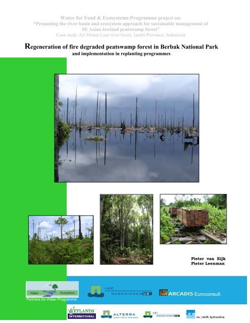
Regeneration of fire degraded peatswamp forest in Berbak National ...
Regeneration of fire degraded peatswamp forest in Berbak National ...
Regeneration of fire degraded peatswamp forest in Berbak National ...

You also want an ePaper? Increase the reach of your titles
YUMPU automatically turns print PDFs into web optimized ePapers that Google loves.
Water for Food & Ecosystems Programme project on:<br />
“Promot<strong>in</strong>g the river bas<strong>in</strong> and ecosystem approach for susta<strong>in</strong>able management <strong>of</strong><br />
SE Asian lowland <strong>peatswamp</strong> <strong>forest</strong>”<br />
Case study Air Hitam Laut river bas<strong>in</strong>, Jambi Prov<strong>in</strong>ce, Indonesia<br />
<strong>Regeneration</strong> <strong>of</strong> <strong>fire</strong> <strong>degraded</strong> <strong>peatswamp</strong> <strong>forest</strong> <strong>in</strong> <strong>Berbak</strong> <strong>National</strong> Park<br />
and implementation <strong>in</strong> replant<strong>in</strong>g programmes<br />
Partners for Water Programme<br />
Pieter van Eijk<br />
Pieter Leenman<br />
Euroconsult
Water for Food & Ecosystems Programme project on:<br />
“Promot<strong>in</strong>g the river bas<strong>in</strong> and ecosystem approach for susta<strong>in</strong>able management <strong>of</strong><br />
SE Asian lowland <strong>peatswamp</strong> <strong>forest</strong>”<br />
Case study Air Hitam Laut river bas<strong>in</strong>, Jambi Prov<strong>in</strong>ce, Indonesia<br />
<strong>Regeneration</strong> <strong>of</strong> <strong>fire</strong> <strong>degraded</strong> <strong>peatswamp</strong> <strong>forest</strong> <strong>in</strong> <strong>Berbak</strong> <strong>National</strong> Park<br />
and implementation <strong>in</strong> replant<strong>in</strong>g programmes<br />
July 2004<br />
Pieter van Eijk<br />
Pieter Leenman<br />
Supervised by: Drs. W. Giesen, Arcadis Euroconsult<br />
Pr<strong>of</strong>. Dr. M.G.C. Schouten, Wagen<strong>in</strong>gen<br />
University<br />
This report can be cited as:<br />
Eijk, P. van & P.H. Leenman, 2004. <strong>Regeneration</strong> <strong>of</strong> <strong>fire</strong> <strong>degraded</strong> <strong>peatswamp</strong> <strong>forest</strong> <strong>in</strong> <strong>Berbak</strong><br />
<strong>National</strong> Park and implementation <strong>in</strong> replant<strong>in</strong>g programmes. Water for Food & Ecosystems<br />
Programme project on: “Promot<strong>in</strong>g the river bas<strong>in</strong> and ecosystem approach for susta<strong>in</strong>able<br />
management <strong>of</strong> SE Asian lowland <strong>peatswamp</strong> <strong>forest</strong>” Case study Air Hitam Laut river bas<strong>in</strong>, Jambi<br />
Prov<strong>in</strong>ce, Indonesia. Alterra Green World Research, Wagen<strong>in</strong>gen, The Netherlands<br />
Keywords: <strong>peatswamp</strong> <strong>forest</strong>, regeneration, succession, re<strong>forest</strong>ation, rehabilitation, vegetation, Pieter van Macaranga, Eijk<br />
ferns, <strong>forest</strong> <strong>fire</strong>s, El Niño, <strong>Berbak</strong>, Sumatra, Indonesia<br />
Pieter Leenman
Contents<br />
PREFACE ............................................................................................................................................... I<br />
EXECUTIVE SUMMARY ...................................................................................................................II<br />
ACKNOWLEDGEMENTS ..................................................................................................................V<br />
GLOSSARY........................................................................................................................................VII<br />
LIST OF ANNEXES ........................................................................................................................ VIII<br />
LIST OF FIGURES............................................................................................................................. IX<br />
LIST OF TABLES............................................................................................................................... XI<br />
1. INTRODUCTION.........................................................................................................................1<br />
1.1. PROBLEM FORMULATION .......................................................................................................1<br />
1.2. GOALS....................................................................................................................................2<br />
2. SOUTHEAST ASIAN PEATSWAMP FORESTS AND THEIR ECOLOGICAL<br />
SIGNIFICANCE................................................................................................................................3<br />
2.1. GENESIS AND FORMATION OF TROPICAL PEATS ......................................................................3<br />
2.2. DISTRIBUTION........................................................................................................................5<br />
2.3. ECOLOGY ...............................................................................................................................5<br />
2.4. VALUES OF PEATSWAMP FORESTS ..........................................................................................7<br />
2.5. THREATS OF PEATSWAMP FORESTS ........................................................................................8<br />
2.6. FOREST FIRES IN INDONESIA.................................................................................................10<br />
2.7. NATURAL REGENERATION: STATE OF THE ART.....................................................................11<br />
3. BERBAK NATIONAL PARK...................................................................................................13<br />
4. METHODOLOGY .....................................................................................................................17<br />
4.1. SELECTION OF RESEARCH SITES............................................................................................17<br />
4.2. ITINERARY AND LOGISTICS...................................................................................................18<br />
4.3. DATA COLLECTION...............................................................................................................21<br />
4.3.1. Position<strong>in</strong>g <strong>of</strong> transects ..................................................................................................21<br />
4.3.2. Collection <strong>of</strong> biotic data .................................................................................................21<br />
4.3.3. Collection <strong>of</strong> abiotic data ...............................................................................................23<br />
4.4. DATA STORAGE AND ANALYSES...........................................................................................24<br />
4.4.1. Data storage ...................................................................................................................24<br />
4.4.2. Analysis...........................................................................................................................25<br />
5. RESULTS ....................................................................................................................................26<br />
5.1. ANALYSIS OF SATELLITE IMAGENARY AND PRE-SELECTION OF RESEARCH LOCATIONS ........26<br />
5.1.1. Landsat and HotSpot ......................................................................................................26<br />
5.1.2. Radar ..............................................................................................................................30<br />
5.1.3. Results <strong>of</strong> site selection...................................................................................................33<br />
5.2. SITE DESCRIPTIONS ..............................................................................................................34<br />
5.3. FLORAL DIVERSITY ..............................................................................................................34<br />
5.3.1. Species composition........................................................................................................34<br />
5.3.2. Occurrence <strong>of</strong> surviv<strong>in</strong>g trees.........................................................................................36<br />
5.4. INFLUENCE OF ABIOTIC FACTORS ON VEGETATION...............................................................38<br />
5.4.1. Species composition <strong>in</strong> TWINSPAN................................................................................39<br />
5.4.2. Description <strong>of</strong> vegetation types based on species composition (TWINSPAN)................41<br />
5.4.3. Forest structure ..............................................................................................................42
5.4.4. Basal area.......................................................................................................................42<br />
5.4.5. Pr<strong>in</strong>cipal Correspondence Analysis (PCA) <strong>in</strong> CANOCO ...............................................43<br />
5.4.6. Determ<strong>in</strong>ation <strong>of</strong> vegetation types based on species composition and <strong>forest</strong> structure..47<br />
5.4.7. Description <strong>of</strong> vegetation types.......................................................................................48<br />
5.5. REGENERATION....................................................................................................................55<br />
5.5.1. Swamp <strong>forest</strong> regeneration: A hypothetical sequence <strong>of</strong> succession. .............................55<br />
5.5.2. Stimulators to successful regeneration ...........................................................................59<br />
5.5.3. Inhibitors to successful regeneration..............................................................................61<br />
5.6. CONDITIONS OF THE PARK ...................................................................................................62<br />
5.6.1. Illegal activities ..............................................................................................................62<br />
5.6.2. Animal observations .......................................................................................................65<br />
6. DISCUSSION AND CONCLUSION.........................................................................................69<br />
6.1. CONCLUSIONS ......................................................................................................................69<br />
6.2. DISCUSSION .........................................................................................................................72<br />
7. IMPLEMENTATION OF RESULTS AND RECOMMENDATIONS..................................74<br />
7.1. IMPLEMENTATION OF RESULTS IN REFORESTATION SCHEMES...............................................74<br />
7.1.1. Site selection...................................................................................................................74<br />
7.1.2. Selection <strong>of</strong> species.........................................................................................................77<br />
7.2. RECOMMENDATIONS FOR REHABILITATION PROGRAMMES...................................................79<br />
8. REFERENCES............................................................................................................................80<br />
9. ANNEXES ...................................................................................................................................83
<strong>Regeneration</strong> <strong>of</strong> <strong>fire</strong> <strong>degraded</strong> <strong>peatswamp</strong> <strong>forest</strong> <strong>in</strong> <strong>Berbak</strong> <strong>National</strong> Park and implementation <strong>in</strong> replant<strong>in</strong>g programmes<br />
Preface<br />
This study comprises our major thesis and is part <strong>of</strong> our MSc Biology (specialisation<br />
Ecology) studies at Wagen<strong>in</strong>gen University, The Netherlands. From November 2003 to June<br />
2004 we spent many hours study<strong>in</strong>g <strong>peatswamp</strong> <strong>forest</strong> ecology <strong>in</strong> general and <strong>peatswamp</strong><br />
<strong>forest</strong> post-<strong>fire</strong> regeneration <strong>in</strong> particular, both <strong>in</strong> The Netherlands and <strong>in</strong> Indonesia. In total<br />
more than six weeks were spent <strong>in</strong> <strong>Berbak</strong> <strong>National</strong> Park, for acquisition <strong>of</strong> field data on flora,<br />
fauna and abiotic factors. There we soon discovered why so few scientists have ventured <strong>in</strong>to<br />
<strong>peatswamp</strong> <strong>forest</strong> until now. We had to deal with hazardous ants, angry bees, dozens <strong>of</strong><br />
snakes, obstructed rivers and strangl<strong>in</strong>g fern vegetation. We had to wade or swim through<br />
floodpla<strong>in</strong>s <strong>in</strong> search <strong>of</strong> suitable research locations and spent the night <strong>in</strong> mosquito <strong>in</strong>fested<br />
camps. There we discovered the warmth and friendl<strong>in</strong>ess <strong>of</strong> local fishermen and the people<br />
that accompanied us on the trips. We found the beauty and richness <strong>of</strong> the <strong>peatswamp</strong> <strong>forest</strong><br />
that has not yet been affected by the <strong>forest</strong> <strong>fire</strong>s and experienced the enormous value <strong>of</strong> this<br />
<strong>National</strong> Park for flora, fauna and local communities. But we also encountered the activities<br />
that strongly threaten the parks <strong>in</strong>tegrity; the many loggers that deteriorate the park at a<br />
terrify<strong>in</strong>g rate, the unsusta<strong>in</strong>able harvest <strong>of</strong> non timber <strong>forest</strong> products and poach<strong>in</strong>g <strong>of</strong> birds<br />
and reptiles. The ongo<strong>in</strong>g dra<strong>in</strong>age <strong>of</strong> farmland and <strong>forest</strong> concession areas that strongly<br />
<strong>in</strong>fluence Air Hitam Laut’s complete catchment area. And <strong>of</strong> course the outbreak <strong>of</strong> <strong>forest</strong><br />
<strong>fire</strong>s, that already <strong>degraded</strong> more than ten percent <strong>of</strong> the park. These activities destroy <strong>Berbak</strong><br />
at an alarm<strong>in</strong>g rate and if they are not stopped on a very short term, <strong>Berbak</strong> will be lost for<br />
future generations. Tigers, rh<strong>in</strong>o’s and white-w<strong>in</strong>ged ducks will disappear together with a<br />
complete ecosystem as already happened <strong>in</strong> other parts <strong>of</strong> Sumatra’s coastal pla<strong>in</strong>. Still<br />
however there rema<strong>in</strong>s hope. More and more people recognise the enormous value <strong>of</strong><br />
<strong>peatswamp</strong> <strong>forest</strong>s for both communities and nature. They work together to promote<br />
susta<strong>in</strong>able management and are prepared to battle illegal logg<strong>in</strong>g and outbreak <strong>of</strong> wild <strong>fire</strong>s.<br />
Ongo<strong>in</strong>g research clarifies patterns <strong>in</strong> socio-economy, hydrology and ecology <strong>in</strong> and around<br />
<strong>peatswamp</strong> <strong>forest</strong>s. Information cont<strong>in</strong>ues to be collected, both from the safe surround<strong>in</strong>gs <strong>of</strong><br />
a computer desk and submerged <strong>in</strong> the centre <strong>of</strong> a flooded <strong>peatswamp</strong> <strong>forest</strong>. This report is<br />
meant to make a small contribution to the understand<strong>in</strong>g <strong>of</strong> the ecology <strong>of</strong> <strong>fire</strong>-<strong>degraded</strong><br />
<strong>peatswamp</strong> <strong>forest</strong>s and it will hopefully help to save Indonesia’s <strong>peatswamp</strong> <strong>forest</strong>s for future<br />
generations.<br />
Wagen<strong>in</strong>gen, The Netherlands, July 2004,<br />
Pieter Leenman (Pieter.Leenman@WUR.nl)<br />
Pieter van Eijk (Pieter.Vaneijk@WUR.nl)<br />
I
<strong>Regeneration</strong> <strong>of</strong> <strong>fire</strong> <strong>degraded</strong> <strong>peatswamp</strong> <strong>forest</strong> <strong>in</strong> <strong>Berbak</strong> <strong>National</strong> Park and implementation <strong>in</strong> replant<strong>in</strong>g programmes<br />
Executive summary<br />
Background<br />
From September 1997 to May 1998 enormous <strong>forest</strong> <strong>fire</strong>s spread throughout Indonesia,<br />
destroy<strong>in</strong>g an estimated total <strong>of</strong> 13.18 million hectares <strong>of</strong> <strong>forest</strong> and farmland. The <strong>fire</strong>s were<br />
most destructive <strong>in</strong> peatlands <strong>of</strong> Sumatra and Borneo where extensive tracts <strong>of</strong> <strong>peatswamp</strong><br />
<strong>forest</strong> were affected. Extreme El Niño <strong>in</strong>duced draught, comb<strong>in</strong>ed with logg<strong>in</strong>g activities,<br />
dra<strong>in</strong>age and other human disturbances were the direct causes <strong>of</strong> the outbreak <strong>of</strong> the wild<strong>fire</strong>s.<br />
Between 1 and 2.5 billion tons <strong>of</strong> carbon were released <strong>in</strong>to the atmosphere, contribut<strong>in</strong>g to<br />
15 to 40 percent <strong>of</strong> average global annual carbon emission. Economic damage extended n<strong>in</strong>e<br />
billion US Dollar. Fire affected peatlands face extreme flood<strong>in</strong>g conditions, subsidence,<br />
erosion, salt <strong>in</strong>trusion, and many areas are subject to repetitive burn<strong>in</strong>g.<br />
Few research on regeneration <strong>of</strong> <strong>fire</strong>-<strong>degraded</strong> <strong>peatswamp</strong> <strong>forest</strong>s has been conducted. Many<br />
sites are known to have a poor rate <strong>of</strong> development as extreme environmental circumstances<br />
<strong>in</strong>hibit establishment and growth <strong>of</strong> seedl<strong>in</strong>gs. Often these sites were found to be dom<strong>in</strong>ated<br />
by ferns, grasses or sedges. Lack <strong>of</strong> knowledge on the l<strong>in</strong>k between abiotic circumstances and<br />
tree performance caused many replant<strong>in</strong>g trials <strong>in</strong> <strong>peatswamp</strong> <strong>forest</strong> to fail, as they were<br />
carried out <strong>in</strong> areas with conditions unsuitable for re<strong>forest</strong>ation, although over the years<br />
several tree species have been identified to have potential for re<strong>forest</strong>ation programmes.<br />
Goal<br />
This report as a part <strong>of</strong> the Water for Food and Ecosystems project on: “Promot<strong>in</strong>g the<br />
riverbas<strong>in</strong> and ecosystem approach for susta<strong>in</strong>able management <strong>of</strong> SE Asian lowland<br />
<strong>peatswamp</strong> <strong>forest</strong>” funded by the Dutch government, describes regeneration <strong>of</strong> <strong>fire</strong>-<strong>degraded</strong><br />
<strong>peatswamp</strong> <strong>forest</strong>s <strong>in</strong> <strong>Berbak</strong> <strong>National</strong> Park, a 190,000 ha Ramsar site, situated on Sumatra’s<br />
coastal pla<strong>in</strong>, Jambi Prov<strong>in</strong>ce. The park represents the conditions <strong>of</strong> many <strong>peatswamp</strong> <strong>forest</strong>s<br />
<strong>in</strong> Indonesia; More than 17,000 ha were destroyed dur<strong>in</strong>g the 1997 <strong>fire</strong>s, and the park faces<br />
considerable problems with illegal logg<strong>in</strong>g and dra<strong>in</strong>age. The survey aims at reveal<strong>in</strong>g the<br />
l<strong>in</strong>k between abiotic factors (flood<strong>in</strong>g depth, flood<strong>in</strong>g duration, peat depth, and <strong>fire</strong> history)<br />
and the extend <strong>of</strong> regeneration <strong>in</strong> terms <strong>of</strong> species composition and <strong>forest</strong> structure. In<br />
addition it identifies species that have potential value for re<strong>forest</strong>ation programmes. This<br />
<strong>in</strong>formation comb<strong>in</strong>ed could form the basis for decision mak<strong>in</strong>g (selection <strong>of</strong> appropriate sites<br />
and species) dur<strong>in</strong>g future replant<strong>in</strong>g trials <strong>in</strong> <strong>Berbak</strong> <strong>National</strong> Park and part <strong>of</strong> the<br />
<strong>in</strong>formation, presented <strong>in</strong> this report is transferable to other Southeast Asian <strong>peatswamp</strong><br />
<strong>forest</strong>s.<br />
Methodology<br />
Data on species composition, <strong>forest</strong> structure and abiotic factors has been collected at 16<br />
different sites throughout burnt areas <strong>in</strong> <strong>Berbak</strong>s central zone. These sites differ from each<br />
other <strong>in</strong> <strong>fire</strong> history, flood<strong>in</strong>g conditions and peat depth.<br />
At each research site five relevees were made along (cont<strong>in</strong>uous) transects <strong>of</strong> 100 x 10 metre,<br />
and consequently at all sites together data were collected <strong>in</strong> 80 relevees. In addition, general<br />
observations were made on illegal activities and animals (birds, mammals, reptiles and<br />
amphibians) with<strong>in</strong> and <strong>in</strong> the direct surround<strong>in</strong>gs <strong>of</strong> the park. The data collected <strong>in</strong> the<br />
relevees were stored <strong>in</strong> TURBOVEG and analysed <strong>in</strong> TWINSPAN and CANOCO.<br />
II
<strong>Regeneration</strong> <strong>of</strong> <strong>fire</strong> <strong>degraded</strong> <strong>peatswamp</strong> <strong>forest</strong> <strong>in</strong> <strong>Berbak</strong> <strong>National</strong> Park and implementation <strong>in</strong> replant<strong>in</strong>g programmes<br />
Results<br />
In total 117 plant species have been identified <strong>in</strong> <strong>Berbak</strong>’s <strong>fire</strong>-<strong>degraded</strong> areas and comb<strong>in</strong>ed<br />
with f<strong>in</strong>d<strong>in</strong>gs dur<strong>in</strong>g a rapid survey <strong>in</strong> 2003 (Giesen, 2004), this results <strong>in</strong> a list <strong>of</strong> 148 species<br />
that were found <strong>in</strong> burnt areas <strong>of</strong> Air Hitam Laut’s catchment area. 46 Species are considered<br />
as common <strong>of</strong> which 20 trees, eight climbers, seven ferns, five palms, two shrubs, two sedges,<br />
one grass and one aquatic herb. 26 Species <strong>of</strong> surviv<strong>in</strong>g trees, palms and climbers have been<br />
observed <strong>of</strong> which eight are commonly encountered.<br />
General observations <strong>in</strong>dicate that illegal logg<strong>in</strong>g activities occur year round, but ma<strong>in</strong>ly <strong>in</strong><br />
the western side <strong>of</strong> the park. Radar evidence clarifies that pre-<strong>fire</strong> disturbance was more<br />
<strong>in</strong>tense than previously assumed. 107 Bird, 13 mammal and 14 reptile species have been<br />
noted with<strong>in</strong> <strong>Berbak</strong> <strong>National</strong> Park and just beyond its borders. Although the <strong>fire</strong>s caused a<br />
significant loss <strong>in</strong> biodiversity, several species have clearly benefited from the <strong>forest</strong> <strong>fire</strong>s.<br />
Notable is the f<strong>in</strong>d<strong>in</strong>g <strong>of</strong> Sumatra’s second breed<strong>in</strong>g colony <strong>of</strong> Oriental Darter (Anh<strong>in</strong>ga<br />
melanogaster) <strong>in</strong> <strong>Berbak</strong>’s burnt core zone.<br />
Species composition, diversity and <strong>forest</strong> structure are strongly dependent on abiotic factors.<br />
S<strong>in</strong>gle burnt sites that face shallow and short flood<strong>in</strong>g are rich <strong>in</strong> species and have a well<br />
developed <strong>forest</strong> structure. Tree diversity is high and many sites are covered with a closed<br />
Macaranga canopy. Multiple burned sites that face deep and prolonged flood<strong>in</strong>g have a low<br />
species diversity and a poorly developed <strong>forest</strong> structure as they are largely devoid <strong>of</strong> trees.<br />
Sedges, grasses or ferns are dom<strong>in</strong>ant. Peat depth is expected to positively effect regeneration<br />
and structural development <strong>of</strong> s<strong>in</strong>gle burnt sites, although only a weak correlation was found.<br />
On the other hand a rema<strong>in</strong><strong>in</strong>g peat layer causes a significant rise <strong>in</strong> <strong>fire</strong> susceptibility and<br />
consequently this factor negatively impacts regeneration <strong>in</strong> many multiple burnt sites.<br />
Burnt <strong>peatswamp</strong> <strong>forest</strong>s were observed to have a rather strict pattern <strong>of</strong> regeneration. Sites<br />
that are dom<strong>in</strong>ated by grasses and sedges become gradually dom<strong>in</strong>ated by ferns as<br />
accumulation <strong>of</strong> organic materials slowly decrease flood<strong>in</strong>g depth and duration. On their turn<br />
these fern dom<strong>in</strong>ated areas are slowly colonised by Alstonia pneumatophora and Macaranga<br />
pru<strong>in</strong>osa respectively. In subsequent stages Macaranga forms a closed canopy layer. This<br />
enables typical <strong>peatswamp</strong> <strong>forest</strong> species to settle and the <strong>fire</strong>-<strong>degraded</strong> area slowly<br />
redevelops <strong>in</strong>to its ‘orig<strong>in</strong>al’ state. Multiple <strong>fire</strong>s reverse the process and as flood<strong>in</strong>g<br />
conditions usually <strong>in</strong>crease after each subsequent <strong>fire</strong>, these areas slowly turn <strong>in</strong>to floodpla<strong>in</strong>s<br />
or lake habitats that are very species poor and that do not regenerate on the short term.<br />
Several factors were observed to have a positive effect on regeneration. Formation <strong>of</strong> deep<br />
peat packages consist<strong>in</strong>g <strong>of</strong> dead and liv<strong>in</strong>g fern roots and leaves significantly reduces<br />
flood<strong>in</strong>g depth and provides an elevated growth medium for trees that are not tolerant to<br />
prolonged and deep flood<strong>in</strong>g. Presence <strong>of</strong> Licuala paludosa palms is hypothesised to decrease<br />
<strong>fire</strong> <strong>in</strong>tensity. On the other hand <strong>in</strong>cidental floods that can kill numerous seedl<strong>in</strong>gs may<br />
negatively <strong>in</strong>fluence the regeneration process.<br />
Based on species composition and <strong>forest</strong> structure, six vegetation types have been identified<br />
<strong>in</strong> <strong>Berbak</strong>’s <strong>fire</strong>-<strong>degraded</strong> areas:<br />
Type 1: Pandanus and Thoracostachyum dom<strong>in</strong>ated lake-type<br />
Type 2: Hymenachne dom<strong>in</strong>ated seasonal lake-type<br />
Type 3: Sedge and Fern dom<strong>in</strong>ated early regeneration-type<br />
Subtype 3a: Sedge dom<strong>in</strong>ated early regeneration- type (flooded)<br />
Subtype 3b: Fern dom<strong>in</strong>ated early regeneration- type (less flooded)<br />
Type 4: Nephrolepis dom<strong>in</strong>ated tree establishment- type<br />
Type 5: Macaranga dom<strong>in</strong>ated early <strong>forest</strong>- type<br />
Type 6: Macaranga dom<strong>in</strong>ated well developed <strong>forest</strong>- type<br />
These types are strongly correlated to specific abiotic conditions and can be identified based<br />
on their characteristic species composition.<br />
III
<strong>Regeneration</strong> <strong>of</strong> <strong>fire</strong> <strong>degraded</strong> <strong>peatswamp</strong> <strong>forest</strong> <strong>in</strong> <strong>Berbak</strong> <strong>National</strong> Park and implementation <strong>in</strong> replant<strong>in</strong>g programmes<br />
Implementation <strong>in</strong> replant<strong>in</strong>g trials<br />
The different vegetation types can be used to assess an area’s suitability for re<strong>forest</strong>ation, as<br />
the rate <strong>of</strong> a type’s natural development, represents its potential for replant<strong>in</strong>g programmes.<br />
Each type has been assigned a comb<strong>in</strong>ed suitability/priority rank<strong>in</strong>g, that <strong>in</strong>dicates a site’s<br />
potential for rehabilitation. Together with assessment <strong>of</strong> legislational, social, logistical and<br />
f<strong>in</strong>ancial constra<strong>in</strong>ts, this should lead the site selection procedure. Type 3b and 4 were found<br />
to be the best candidates for re<strong>forest</strong>ation. Type 5 and 6 have a very strong rate <strong>of</strong> natural<br />
development and should not be considered as primary target. Type 1, 2 and 3a have harsh<br />
abiotic conditions and are not suitable for replant<strong>in</strong>g. The 20 trees and two palms that were<br />
found to commonly occur <strong>in</strong> <strong>Berbak</strong>’s <strong>fire</strong>-<strong>degraded</strong> areas, are most promis<strong>in</strong>g for replant<strong>in</strong>g<br />
trials, provided that they are planted under circumstances similar to where they naturally<br />
occur. They could then be considered as target species. Macaranga pru<strong>in</strong>osa is <strong>of</strong> <strong>in</strong>terest <strong>in</strong><br />
particular, as the species was found to strongly promote the natural regeneration process.<br />
Other species with high potential are: Pternandra galeata, Barr<strong>in</strong>gtonia macrostachya,<br />
Mallotus muticus, Barr<strong>in</strong>gtonia racemosa, Syzygium zipelliana, Pandanus helicopus,<br />
Pholidocarpus sumatranus and Licuala paludosa.<br />
Most <strong>of</strong> the <strong>in</strong>formation presented <strong>in</strong> this report is transferable to <strong>fire</strong>-<strong>degraded</strong> <strong>peatswamp</strong><br />
<strong>forest</strong>s <strong>in</strong> other parts <strong>of</strong> Southeast Asia. Information on species composition is very site<br />
specific and cannot automatically be applied elsewhere.<br />
IV
<strong>Regeneration</strong> <strong>of</strong> <strong>fire</strong> <strong>degraded</strong> <strong>peatswamp</strong> <strong>forest</strong> <strong>in</strong> <strong>Berbak</strong> <strong>National</strong> Park and implementation <strong>in</strong> replant<strong>in</strong>g programmes<br />
Acknowledgements<br />
This survey could never have been accomplished without the enthusiasm and support <strong>of</strong> a<br />
large number <strong>of</strong> people.<br />
First <strong>of</strong> all we would like to thank our Dutch supervisors Wim Giesen (Arcadis Euroconsult)<br />
and Matthijs Schouten (Wagen<strong>in</strong>gen University) for their useful and critical comments.<br />
They <strong>of</strong>ten spent their free time to discuss <strong>peatswamp</strong> <strong>forest</strong> related topics and <strong>in</strong>spired us<br />
with their enthusiasm.<br />
We are very grateful to our Indonesian supervisor Iwan Tricahyo Wibisono (Wetlands<br />
International-Indonesia Programme) for his support dur<strong>in</strong>g the different plann<strong>in</strong>g procedures<br />
on Sumatra and for shar<strong>in</strong>g his knowledge on <strong>peatswamp</strong> <strong>forest</strong> ecology.<br />
Henk Wösten (Alterra Green World Research) provided us with splendid facilities <strong>in</strong> the<br />
Alterra organisation, was <strong>of</strong> great support <strong>in</strong> the plann<strong>in</strong>g <strong>of</strong> our stay <strong>in</strong> Indonesia and<br />
provided us with a lot <strong>of</strong> <strong>in</strong>formation regard<strong>in</strong>g <strong>peatswamp</strong> <strong>forest</strong> hydrology.<br />
We would like to thank Hendra Simbolon and Dian Afrianti (Jambi University) for their<br />
great responsibility dur<strong>in</strong>g (preparation <strong>of</strong>) the field trips, their good company and useful<br />
discussions on <strong>Berbak</strong>’s soils.<br />
In addition we are grateful to the follow<strong>in</strong>g persons:<br />
Wetlands International-Indonesia Programme- Pak Dibjo Sartono and Pak Nyoman<br />
Suryadiputra for their warm welcome, support and discussions regard<strong>in</strong>g the project’s<br />
activities.<br />
Yus Rusila Noor for the discussions on <strong>Berbak</strong> <strong>National</strong> Park and on bird observations <strong>in</strong><br />
particular. Labueni Siboro and Anggie for their assistance with preparation <strong>of</strong> the fieldwork<br />
and acquisition <strong>of</strong> background <strong>in</strong>formation on <strong>peatswamp</strong> <strong>forest</strong> ecology, and <strong>of</strong> course all the<br />
other people <strong>in</strong> the <strong>of</strong>fice, who were so hospitable dur<strong>in</strong>g our stay <strong>in</strong> Bogor.<br />
Taman Nasional <strong>Berbak</strong>- Pak Istanto (head <strong>of</strong> <strong>Berbak</strong> NP) for the discussions on <strong>Berbak</strong><br />
<strong>National</strong> Park and his support to the fieldwork activities. Faried, Muajir<strong>in</strong>, Alfian, Supriono<br />
and Muhamadijah for their assistance <strong>in</strong> the field.<br />
D<strong>in</strong>as Kehutanan- Pak Gatot Moeryanto (head <strong>of</strong> D<strong>in</strong>as) for the discussion on illegal<br />
activities <strong>in</strong> <strong>Berbak</strong> <strong>National</strong> Park and his support to the project. Faisal for provid<strong>in</strong>g the<br />
HotSpot data set. Suparman for jo<strong>in</strong><strong>in</strong>g the project team <strong>in</strong>to the field.<br />
Herbarium Bogoriense/Lipi- Mrs. Afriast<strong>in</strong>i for her advice on collection <strong>of</strong> herbarium<br />
specimens and the quick identification <strong>of</strong> the specimens collected. Herw<strong>in</strong>t Simbolon for the<br />
discussion on regeneration <strong>of</strong> <strong>fire</strong>-<strong>degraded</strong> <strong>peatswamp</strong> <strong>forest</strong>s.<br />
Bogor Agricultural University- Bambanghero Suhardjo for the discussion on <strong>forest</strong> <strong>fire</strong>s,<br />
Mr. Istomo for shar<strong>in</strong>g his knowledge on <strong>peatswamp</strong> <strong>forest</strong> Ecology and <strong>in</strong>formation on<br />
<strong>peatswamp</strong> <strong>forest</strong> plant species.<br />
Alterra Green World Research- Stephan Hennekens for provid<strong>in</strong>g s<strong>of</strong>tware for vegetational<br />
analysis.<br />
V
<strong>Regeneration</strong> <strong>of</strong> <strong>fire</strong> <strong>degraded</strong> <strong>peatswamp</strong> <strong>forest</strong> <strong>in</strong> <strong>Berbak</strong> <strong>National</strong> Park and implementation <strong>in</strong> replant<strong>in</strong>g programmes<br />
Wagen<strong>in</strong>gen University- Dirk Hoekman for his k<strong>in</strong>d permission to use radar images that<br />
provide important <strong>in</strong>formation on flood<strong>in</strong>g duration. Karlè Sýkora for his advice on statistical<br />
analysis. Rick van der Heijden for his k<strong>in</strong>d help with ref<strong>in</strong><strong>in</strong>g the f<strong>in</strong>al layout <strong>of</strong> the report.<br />
Herbarium Leiden- Paul Kessler for his advice on collection <strong>of</strong> herbarium specimens.<br />
Pt. Putra Duta Indah Wood- Surianto for his assistance <strong>in</strong> the field.<br />
University Malaysia Sarawak- Mr. Indraneil Das for his k<strong>in</strong>d help with the identification <strong>of</strong><br />
reptiles and amphibians.<br />
Local villages- Acong, Adi, Ajeng, Ali, Bahar, Bujang, Darwis, Eddi, Giman, Latib, Nasrul,<br />
Sumardi, Tamr<strong>in</strong>, Yunus, Pak Leman and Pak Subri for their assistance <strong>in</strong> keep<strong>in</strong>g upright <strong>in</strong><br />
the field enabl<strong>in</strong>g to do research.<br />
Air Hitam Laut project team- And <strong>of</strong> course, last but not least, the project team members<br />
who enabled us to study regeneration <strong>in</strong> <strong>Berbak</strong>’s <strong>fire</strong>-<strong>degraded</strong> areas: Ingrid Gevers<br />
(International Agricultural Centre, The Netherlands), Marcel Silvius (Wetlands International,<br />
The Netherlands), Agus, Pak Aswandi, Dede, Dipa, Hendarto, Mas Kus and Rachid.<br />
Especially we would like to thank Christian Siderius, for his k<strong>in</strong>d help with regard to GIS<br />
<strong>in</strong>formation, assistance with GIS applications and discussion on hydrology.<br />
VI
<strong>Regeneration</strong> <strong>of</strong> <strong>fire</strong> <strong>degraded</strong> <strong>peatswamp</strong> <strong>forest</strong> <strong>in</strong> <strong>Berbak</strong> <strong>National</strong> Park and implementation <strong>in</strong> replant<strong>in</strong>g programmes<br />
Glossary<br />
Asl Above sea level<br />
AHD Air Hitam Dalam River<br />
AHL Air Hitam Laut River<br />
Basal area Total surface per hectare covered by tree stems exceed<strong>in</strong>g five<br />
centimetres <strong>in</strong> diameter<br />
B.P. Before present<br />
CCFPI Climate Change Forests and Peatlands <strong>in</strong> Indonesia- project<br />
CIDA Canadian International Development Agency<br />
Core zone Large burnt area <strong>in</strong> the centre <strong>of</strong> <strong>Berbak</strong> <strong>National</strong> Park<br />
DBH Diameter at breast height ( 1,3 m)<br />
Desa Village<br />
D<strong>in</strong>as Kehutanan Forestry service<br />
DSS Decision Support System<br />
ENSO El Niño Southern Oscillation<br />
Kem Camp<br />
Ketek Motorised canoe<br />
NTFP Non Timber Forest product.<br />
NP <strong>National</strong> Park<br />
Parang-men Locals assist<strong>in</strong>g <strong>in</strong> cutt<strong>in</strong>g transects through vegetation with machete.<br />
Parit Agricultural dra<strong>in</strong>age canal also used for transport<br />
Peat, ombrogenous Peat with nutrient poor conditions; purely ra<strong>in</strong>water fed<br />
Peat, topogenous Peat with nutrient rich circumstances; groundwater fed<br />
Perahu Canoe<br />
Pompong large motor boot, ma<strong>in</strong>ly used for fish<strong>in</strong>g purposes and cargo<br />
transport<br />
Pt. PDIW Putra Duta Indah Wood, logg<strong>in</strong>g concession company<br />
Ramsar site Wetland <strong>of</strong> <strong>in</strong>ternational importance follow<strong>in</strong>g the criteria “as<br />
adopted by he 4 th , 6 th and 7 th meet<strong>in</strong>g <strong>of</strong> the conference <strong>of</strong> contract<strong>in</strong>g<br />
parties to the conventtion <strong>of</strong> Wetlands (Ramsar, Iran, 1971)”, which<br />
concerns representative, rare or unique wetland types, wetlands that<br />
support vulnerable or endangered species or significant numbers <strong>of</strong><br />
animals.<br />
Rumah Biru Ranger post at the confluence <strong>of</strong> Air Hitam Laut River and Simpang<br />
Melaka River.<br />
Simpang Junction<br />
Site A place where research is conducted, noted with e.g. AHL N, SM A<br />
SM Simpang Melaka River<br />
Sungai River<br />
VII
<strong>Regeneration</strong> <strong>of</strong> <strong>fire</strong> <strong>degraded</strong> <strong>peatswamp</strong> <strong>forest</strong> <strong>in</strong> <strong>Berbak</strong> <strong>National</strong> Park and implementation <strong>in</strong> replant<strong>in</strong>g programmes<br />
List <strong>of</strong> Annexes<br />
Annex 1 HotSpots that occurred <strong>in</strong> 2001, 2002 and 2003 <strong>in</strong> and near <strong>Berbak</strong> NP<br />
Annex 2 It<strong>in</strong>erary <strong>of</strong> the fieldwork period 30 January –29 April 2004<br />
Annex 3 Relevé data sheet (example)<br />
Annex 4 Herbarium note book (example)<br />
Annex 5 Site descriptions (16 sites)<br />
Annex 6 Species list Burnt <strong>peatswamp</strong> <strong>forest</strong>, <strong>Berbak</strong> NP (117 species)<br />
Annex 7 Complete species list Burnt <strong>peatswamp</strong> <strong>forest</strong>, <strong>Berbak</strong> NP (148 species)<br />
Annex 8 Common species <strong>of</strong> Burnt <strong>peatswamp</strong> <strong>forest</strong>, <strong>Berbak</strong> NP(46 species)<br />
Annex 9 Surviv<strong>in</strong>g species (26 species)<br />
Annex 10 Forest structure<br />
Annex 11 Basal area<br />
Annex 12 Illegal activities<br />
Annex 13 Animal observations: Birds<br />
Annex 14 Animal observations: Mammals<br />
Annex 15 Animal observations: Reptiles and Amphibians<br />
Annex 16 Decision Support System for restoration <strong>of</strong> burnt <strong>peatswamp</strong> <strong>forest</strong><br />
Annex 17 Cd-rom: photographic overview<br />
VIII
<strong>Regeneration</strong> <strong>of</strong> <strong>fire</strong> <strong>degraded</strong> <strong>peatswamp</strong> <strong>forest</strong> <strong>in</strong> <strong>Berbak</strong> <strong>National</strong> Park and implementation <strong>in</strong> replant<strong>in</strong>g programmes<br />
List <strong>of</strong> figures<br />
Figure 2.1 Coastal accretion <strong>in</strong> Air Hitam Laut’s catchment area. Dashed l<strong>in</strong>es represent<br />
hypothetical coastl<strong>in</strong>es <strong>in</strong> geologic time. (After Whitten 2000)<br />
……. 4<br />
Figure 2.2 Cross-section <strong>of</strong> a peat dome (After Bruenig 1990) ……. 4<br />
Figure 2.3 Fires <strong>in</strong>itiated to clear land from vegetation for agriculture or build<strong>in</strong>g purposes,<br />
easily turn <strong>in</strong>to wild <strong>fire</strong>s that can destroy thousands <strong>of</strong> hectares.<br />
9<br />
Figure 2.4 Typical occurrence <strong>of</strong> peat <strong>fire</strong> pits that orig<strong>in</strong>ate from ground <strong>fire</strong>s and move<br />
horizontally <strong>in</strong> the peat soil. (after Artsybashev, 1986)<br />
……. 10<br />
Figure 3.1 Geographical position <strong>of</strong> the research location. Large map depicts <strong>Berbak</strong> NP and<br />
surround<strong>in</strong>g concession areas (dark green). The burnt core zone and the burnt<br />
area along Simpang Melaka River are situated <strong>in</strong> the centre <strong>of</strong> the Park.<br />
……. 16<br />
Figure 4.1 Location <strong>of</strong> research sites <strong>in</strong> the centre <strong>of</strong> <strong>Berbak</strong> NP. ……. 19<br />
Figure 4.2 Position<strong>in</strong>g <strong>of</strong> transects relative to the river ……. 21<br />
Figure 4.3 Different height classes used for characterization <strong>of</strong> herb and tree structure<br />
respectively with<strong>in</strong> a regenerat<strong>in</strong>g <strong>forest</strong><br />
……. 22<br />
Figure 4.4 Measurements taken <strong>in</strong> the field: a.) Maximum flood<strong>in</strong>g depth; b.) current water<br />
level; c.) Peat depth; d.) M<strong>in</strong>eral subsoil.<br />
……. 23<br />
Figure 4.5 Vegetation dy<strong>in</strong>g zone ……. 23<br />
Figure 5.1 Part <strong>of</strong> 1992 Radar image that <strong>in</strong>dicates clear-fell<strong>in</strong>g <strong>in</strong> <strong>Berbak</strong>’s core zone. 27<br />
Figure 5.2 Large camp along the Simpang Kubu River. 27<br />
Figure 5.3a Satellite image 16 April 1983. ……. 28<br />
Figure 5.3b Satellite image 9 June 1989. ……. 28<br />
Figure 5.3c Satellite image 16 May 1992. ……. 28<br />
Figure 5.3d Satellite image 18 August 1997. ……. 28<br />
Figure 5.3e Satellite image 1 May 1998 ……. 29<br />
Figure 5.3f Satellite image 1 September 1999 ……. 29<br />
Figure 5.3g Satellite image 8 Augustus 2002 ……. 29<br />
Figure 5.4a Radar image 4 Augustus 1998. ……. 31<br />
Figure 5.4b Radar image 17 September 1998. ……. 31<br />
Figure 5.4c Radar image 25 March 1998. ……. 32<br />
Figure 5.4d Radar image 8 May 1998. ……. 32<br />
Figure 5.5 Occurrence <strong>of</strong> <strong>fire</strong>s <strong>in</strong> <strong>Berbak</strong>’s central zone ……. 33<br />
Figure 5.6 Occurrence <strong>of</strong> different <strong>fire</strong> survival mechanisms <strong>in</strong> trees. ……. 37<br />
Figure 5.7 Barr<strong>in</strong>gtonia racemosa has strong resprout<strong>in</strong>g capacities and is able to resprout<br />
after several subsequent <strong>fire</strong>s.<br />
38<br />
Figure 5.8 Dendrogram represent<strong>in</strong>g the divisions made by TWINSPAN on the basis <strong>of</strong><br />
<strong>in</strong>dicator species.<br />
……. 39<br />
Figure 5.9 TWINSPAN Two-way table <strong>in</strong>dicat<strong>in</strong>g TWINSPAN clusters and f<strong>in</strong>al vegetation<br />
types.<br />
40<br />
Figure 5.10a Correlation between Basal area and flood<strong>in</strong>g duration. ……. 43<br />
Figure 5.10b Correlation between Basal area and peat depth. ……. 43<br />
Figure 5.10c Correlation between Basal area and maximum depth <strong>of</strong> flood<strong>in</strong>g. ……. 43<br />
Figure 5.11 PCA Bi-plot: Relevees and environmental factors (species composition). ……. 44<br />
Figure 5.12 PCA Bi-plot: Common species and environmental factors (species composition). ……. 45<br />
Figure 5.13 PCA Bi-plot: Relevees and environmental factors (<strong>forest</strong> structure). ……. 46<br />
Figure 5.14 Schematization <strong>of</strong> hypothetical sequence <strong>of</strong> succession <strong>of</strong> <strong>fire</strong> <strong>degraded</strong> <strong>peatswamp</strong><br />
<strong>forest</strong>.<br />
……. 57<br />
Figure 5.15 Forest structure as assumed to occur <strong>in</strong> the hypothetical sequence <strong>of</strong> succession. ……. 59<br />
IX
<strong>Regeneration</strong> <strong>of</strong> <strong>fire</strong> <strong>degraded</strong> <strong>peatswamp</strong> <strong>forest</strong> <strong>in</strong> <strong>Berbak</strong> <strong>National</strong> Park and implementation <strong>in</strong> replant<strong>in</strong>g programmes<br />
Figure 5.16 Basal areas as assumed to occur <strong>in</strong> the hypothetical sequence <strong>of</strong> succession. ……. 59<br />
Figure 5.17 Fernpackage formation is observed to promote growth <strong>of</strong> Alstonia and Pternandra<br />
seedl<strong>in</strong>gs<br />
……. 60<br />
Figure 5.18 Establishment <strong>of</strong> Pternandra galeata on fern package. ……. 60<br />
Figure 5.19 Frequently loads <strong>of</strong> illegal timber, poached <strong>in</strong> <strong>Berbak</strong> NP, are transported along<br />
Pt. PDIW’s railroad.<br />
……. 63<br />
Figure 5.20 Construction for plunder<strong>in</strong>g <strong>of</strong> Hill Myna’s nest. ……. 64<br />
Figure 5.21 Hill Myna’s are very popular <strong>in</strong> the cage-bird <strong>in</strong>dustry. ……. 64<br />
Figure 7.1 Position<strong>in</strong>g <strong>of</strong> spores on Blechnum <strong>in</strong>dicum. ……. 77<br />
Figure 7.2 Position<strong>in</strong>g <strong>of</strong> spores on Nephrolepis bisserata. ……. 77<br />
X
<strong>Regeneration</strong> <strong>of</strong> <strong>fire</strong> <strong>degraded</strong> <strong>peatswamp</strong> <strong>forest</strong> <strong>in</strong> <strong>Berbak</strong> <strong>National</strong> Park and implementation <strong>in</strong> replant<strong>in</strong>g programmes<br />
List <strong>of</strong> tables<br />
Table 2.1 Different types <strong>of</strong> Southeast Asian peat and their characteristics. ……. 4<br />
Table 2.2 Distribution <strong>of</strong> Peat soils with<strong>in</strong> Southeast Asia ……. 5<br />
Table 2.3 Long term functions, values and uses <strong>of</strong> undisturbed <strong>peatswamp</strong> <strong>forest</strong> -ecosystems<br />
(adapted from James (1991), extended with <strong>in</strong>formation derived from Rieley et al.<br />
(1994).<br />
……. 7<br />
Table 3.1 Ma<strong>in</strong> vegetation types occurr<strong>in</strong>g <strong>in</strong> <strong>Berbak</strong> <strong>National</strong> Park before reallocation <strong>of</strong> its<br />
boundaries (1984).<br />
……. 13<br />
Table 4.1 Ord<strong>in</strong>al coverscale used for estimation <strong>of</strong> species cover. ……. 22<br />
Table 5.1 Species common <strong>in</strong> burnt <strong>peatswamp</strong> <strong>forest</strong> <strong>in</strong> <strong>Berbak</strong> NP identified by Van Eijk &<br />
Leenman (2004) and Giesen (2004)<br />
……. 35<br />
Table 5.2 Abundance <strong>of</strong> tree species, that commonly occur <strong>in</strong> <strong>fire</strong>-<strong>degraded</strong> areas <strong>of</strong> Air Hitam<br />
Laut’s catchment under different environmental circumstances<br />
……. 36<br />
Table 5.3 Tree and palm species commonly occurr<strong>in</strong>g as survivors <strong>in</strong> burnt <strong>peatswamp</strong> <strong>forest</strong>,<br />
<strong>Berbak</strong> NP<br />
……. 37<br />
Table 5.4 F<strong>in</strong>al cluster<strong>in</strong>g based on group<strong>in</strong>g by TWINSPAN and PCA ord<strong>in</strong>ation 47<br />
Table 5.5 Observations support<strong>in</strong>g Licuala- <strong>fire</strong> mitigation theory ……. 61<br />
Table 5.6 Bird species observed that are mentioned <strong>in</strong> literature to prefer <strong>degraded</strong>, shrubby or<br />
open areas.<br />
66<br />
Table 5.7 Observations <strong>of</strong> Crocodilians <strong>in</strong> <strong>Berbak</strong> NP 2004 ……. 68<br />
XI
<strong>Regeneration</strong> <strong>of</strong> <strong>fire</strong> <strong>degraded</strong> <strong>peatswamp</strong> <strong>forest</strong> <strong>in</strong> <strong>Berbak</strong> <strong>National</strong> Park and implementation <strong>in</strong> replant<strong>in</strong>g programmes<br />
1. Introduction<br />
1.1. Problem formulation<br />
In September 1997 Indonesia was affected by one <strong>of</strong> the country’s worst natural disasters ever.<br />
Enormous <strong>fire</strong>s spread throughout the western part <strong>of</strong> the archipelago and destroyed millions <strong>of</strong><br />
hectares <strong>of</strong> <strong>forest</strong> and farmland. The <strong>fire</strong>s persisted for n<strong>in</strong>e months and caused a haze <strong>of</strong> smoke<br />
that reached as far as S<strong>in</strong>gapore and Pen<strong>in</strong>sular Malaysia. More than 13 million hectares were<br />
estimated to have burnt and economic damage extended over n<strong>in</strong>e billion USD (Siegert et al.,<br />
2001 a ). Extreme droughts caused by the El Niño Southern Oscillation (ENSO) event, comb<strong>in</strong>ed<br />
with severe human impacts on the regions ecology and hydrology proved to be the direct cause <strong>of</strong><br />
the <strong>fire</strong> outbreaks. Sites that were affected by logg<strong>in</strong>g, dra<strong>in</strong>age and agriculture were most<br />
susceptible to burn<strong>in</strong>g. The <strong>fire</strong>s were most <strong>in</strong>tense <strong>in</strong> peatlands as they are particularly sensitive<br />
to changes <strong>in</strong> hydrology, have been fac<strong>in</strong>g a high level <strong>of</strong> disturbance dur<strong>in</strong>g the last decades and<br />
conta<strong>in</strong> a huge stock <strong>of</strong> easily combustible materials. These peat <strong>fire</strong>s brought along a wide range<br />
<strong>of</strong> local, regional and even global problems. Emission <strong>of</strong> huge amounts <strong>of</strong> CO2 due to combustion<br />
<strong>of</strong> the upper peat layer has contributed to global warm<strong>in</strong>g (Rieley & Page, 2004; Siegert et al.,<br />
2001 b ). Locally, <strong>fire</strong>s lead to unusually high and prolonged flood<strong>in</strong>g <strong>in</strong> the wet season, subsidence<br />
<strong>of</strong> peat deposits, erosion and salt water <strong>in</strong>trusion. These processes together act as a positive<br />
feedback loop, the disturbance lead<strong>in</strong>g to <strong>fire</strong>s and the <strong>fire</strong>s lead<strong>in</strong>g to <strong>in</strong>creased disturbance. As a<br />
result many <strong>peatswamp</strong>s that burnt <strong>in</strong> 1997 have faced repetitive <strong>fire</strong>s ever s<strong>in</strong>ce, form<strong>in</strong>g a<br />
constant threat to unaffected <strong>peatswamp</strong> <strong>forest</strong>s.<br />
Until now the exact relationship between hydrology and <strong>forest</strong> <strong>fire</strong>s rema<strong>in</strong>s unclear and recovery<br />
<strong>of</strong> <strong>peatswamp</strong> <strong>forest</strong> after <strong>fire</strong> is poorly studied. This makes implementation <strong>of</strong> adequate<br />
measurements to protect the land aga<strong>in</strong>st future <strong>fire</strong>s and to rehabilitate <strong>degraded</strong> areas very<br />
difficult and therefore a wide array <strong>of</strong> studies needs to be performed on hydrology, socioeconomy<br />
and ecology to fill the gap <strong>of</strong> knowledge and to come to a <strong>in</strong>tegrated approach <strong>of</strong><br />
<strong>peatswamp</strong> <strong>forest</strong> management.<br />
The Air Hitam Laut catchment area, situated on Sumatra’s coastal pla<strong>in</strong>, Jambi prov<strong>in</strong>ce,<br />
represents the conditions <strong>of</strong> many <strong>fire</strong> affected areas <strong>in</strong> Indonesia. It is covered by an extensive<br />
peat dome, a large part <strong>of</strong> which is located with<strong>in</strong> <strong>Berbak</strong> <strong>National</strong> Park. This 190,000 hectare<br />
Ramsar site has a unique flora and high conservation value for (migratory) birds and mammals.<br />
The park protects the largest rema<strong>in</strong><strong>in</strong>g stretch <strong>of</strong> <strong>peatswamp</strong> <strong>forest</strong> and freshwater swamp<strong>forest</strong><br />
<strong>in</strong> Sumatra, but is under constant and <strong>in</strong>creas<strong>in</strong>g threat <strong>of</strong> encroachment (<strong>in</strong> the east) and illegal<br />
logg<strong>in</strong>g (<strong>in</strong> the centre and West). In logg<strong>in</strong>g concession areas and farm lands that surround the<br />
park, extensive dra<strong>in</strong>age systems have been constructed to optimize conditions for agriculture and<br />
silviculture. These dra<strong>in</strong>age systems severely impact the park’s hydrology. In 1997 a considerable<br />
part <strong>of</strong> the catchment was affected by the <strong>fire</strong>s, and with<strong>in</strong> <strong>Berbak</strong> NP more than 17,000 hectares<br />
<strong>of</strong> <strong>forest</strong> was destroyed.<br />
1
<strong>Regeneration</strong> <strong>of</strong> <strong>fire</strong> <strong>degraded</strong> <strong>peatswamp</strong> <strong>forest</strong> <strong>in</strong> <strong>Berbak</strong> <strong>National</strong> Park and implementation <strong>in</strong> replant<strong>in</strong>g programmes<br />
The project “Promot<strong>in</strong>g the riverbas<strong>in</strong> and ecosystem approach for susta<strong>in</strong>able management <strong>of</strong><br />
SE Asian lowland <strong>peatswamp</strong> <strong>forest</strong> ” , further referred to as AHL-project, has selected <strong>Berbak</strong><br />
NP for a case study. The project aims to “ asses the nature and impact <strong>of</strong> human activities on the<br />
function<strong>in</strong>g <strong>of</strong> the greater <strong>Berbak</strong> ecosystem, analyze the hydrology <strong>of</strong> the Air Hitam Laut River<br />
and the dependency <strong>of</strong> the coastal communities on the ecosystem health.” This will result <strong>in</strong>: “<br />
Improved understand<strong>in</strong>g <strong>of</strong> the hydrological and ecological function<strong>in</strong>g <strong>of</strong> Southeast Asian<br />
lowland <strong>peatswamp</strong> <strong>forest</strong>, and contribution to an enhanced basel<strong>in</strong>e for policy and decision<br />
mak<strong>in</strong>g <strong>in</strong> relation to <strong>in</strong>tegrated management <strong>of</strong> <strong>peatswamp</strong> river bas<strong>in</strong>s <strong>in</strong> the tropics and <strong>in</strong><br />
particular <strong>Berbak</strong> NP ” (Gevers, 2002).<br />
The project is f<strong>in</strong>anced by the Dutch government under the Partners for Water programme and is<br />
coord<strong>in</strong>ated and lead by the International Agricultural Centre (IAC), The Netherlands and<br />
Wetlands International Indonesia-Programme (WI-IP). The project is implemented by Alterra<br />
Green World research (The Netherlands), Arcadis Euroconsult (The Netherlands), WL/Delft<br />
Hydrolics (The Netherlands), LEI (The Netherlands), Wetlands International (The Netherlands)<br />
and several Indonesian m<strong>in</strong>istries, plann<strong>in</strong>g bureaus and Universities. The Global Environment<br />
Centre (Malaysia) is <strong>in</strong>volved on a regional level.<br />
Three discipl<strong>in</strong>es work jo<strong>in</strong>tly together <strong>in</strong> this project. The hydrology component deals with<br />
collection <strong>of</strong> environmental and hydrological data, modell<strong>in</strong>g and assessment <strong>of</strong> the effect <strong>of</strong><br />
different land use scenario’s on the catchment’s hydrology. The socio-economic component deals<br />
with topics related to local policies and community awareness and requirements for livelihood.<br />
The ecology component studies the state <strong>of</strong> <strong>Berbak</strong> NP <strong>in</strong> general, the extend <strong>of</strong> regeneration <strong>of</strong><br />
<strong>fire</strong>-<strong>degraded</strong> <strong>forest</strong> and the l<strong>in</strong>k between abiotic circumstances and the success <strong>of</strong> regeneration.<br />
In addition it aims to identify possibilities and requirements for re<strong>forest</strong>ation <strong>of</strong> affected areas.<br />
Replant<strong>in</strong>g trials will be conducted and previous trials will be evaluated. This report is part <strong>of</strong> the<br />
ecology component’s output and can be regarded as an extension <strong>of</strong> the report “Causes <strong>of</strong><br />
<strong>peatswamp</strong> <strong>forest</strong> degradation <strong>in</strong> <strong>Berbak</strong> NP, Indonesia, and recommendations for restoration”<br />
(Giesen, 2004). It provides more detailed <strong>in</strong>formation on the floral composition <strong>of</strong> <strong>fire</strong> affected<br />
areas, on the process <strong>of</strong> regeneration <strong>in</strong> general and assesses the <strong>in</strong>fluence <strong>of</strong> several abiotic<br />
factors on regeneration speed. Furthermore, it provides additional <strong>in</strong>formation on the park’s<br />
general conditions.<br />
1.2. Goals<br />
With<strong>in</strong> this study the follow<strong>in</strong>g goals have been formulated:<br />
• Development <strong>of</strong> a better understand<strong>in</strong>g <strong>of</strong> the underly<strong>in</strong>g ecological processes <strong>in</strong><br />
regeneration <strong>of</strong> <strong>fire</strong> affected <strong>peatswamp</strong> <strong>forest</strong> <strong>in</strong> <strong>Berbak</strong> NP, aim<strong>in</strong>g <strong>in</strong> particular at the<br />
<strong>in</strong>fluence <strong>of</strong> different environmental circumstances (flood<strong>in</strong>g depth, flood<strong>in</strong>g duration, <strong>fire</strong><br />
history, soil characteristics and peat depth) on the regeneration process and the extend to<br />
which species composition reflects a certa<strong>in</strong> stage <strong>of</strong> regeneration <strong>of</strong> a <strong>fire</strong>-<strong>degraded</strong><br />
<strong>peatswamp</strong> <strong>forest</strong>.<br />
• Identification <strong>of</strong> tree species that are <strong>of</strong> <strong>in</strong>terest to rehabilitation programmes.<br />
• Development <strong>of</strong> a Decision Support System (DSS) that is a tool for decision mak<strong>in</strong>g <strong>in</strong><br />
<strong>peatswamp</strong> <strong>forest</strong> rehabilitation programmes. The DSS can be used to assess to which<br />
affected areas funds for rehabilitation should be allocated and <strong>in</strong>dicates which species could<br />
be replanted and <strong>in</strong>corporates a number <strong>of</strong> legislational, social and logistic constra<strong>in</strong>ts.<br />
• Acquisition <strong>of</strong> additional <strong>in</strong>formation on <strong>Berbak</strong> NP’s condition <strong>in</strong> respect to:<br />
-Forest <strong>fire</strong>s: distribution and re-occurrence.<br />
-Illegal activities: logg<strong>in</strong>g, poach<strong>in</strong>g and fish<strong>in</strong>g.<br />
-Biodiversity: occurrence <strong>of</strong> birds, mammals, reptiles and amphibians.<br />
2
<strong>Regeneration</strong> <strong>of</strong> <strong>fire</strong> <strong>degraded</strong> <strong>peatswamp</strong> <strong>forest</strong> <strong>in</strong> <strong>Berbak</strong> <strong>National</strong> Park and implementation <strong>in</strong> replant<strong>in</strong>g programmes<br />
2. Southeast Asian <strong>peatswamp</strong> <strong>forest</strong>s and<br />
their ecological significance<br />
2.1. Genesis and formation <strong>of</strong> tropical peats<br />
Over the years peat deposits have established at numerous sites throughout the Southeast Asian<br />
region. They developed at different times and under different abiotic circumstances and due to<br />
these dist<strong>in</strong>ct characteristics the deposits are classified <strong>in</strong> three types: high peats, coastal peats and<br />
bas<strong>in</strong> peats (table 2.1).<br />
Formation <strong>of</strong> high peats, the oldest deposits <strong>in</strong> Southeast Asia, started about 9000 years ago<br />
(Rieley 1991). After term<strong>in</strong>ation <strong>of</strong> the Würm glaciation ten to twelve thousand years B.P., long<br />
periods <strong>of</strong> ra<strong>in</strong>fall caused strong acidification and leach<strong>in</strong>g <strong>of</strong> nutrients <strong>in</strong> elevated watersheds<br />
(30-50 m asl) <strong>in</strong> the <strong>in</strong>terior <strong>of</strong> Kalimantan. These processes created circumstances suitable for<br />
formation <strong>of</strong> ombrogenous peats that are, referr<strong>in</strong>g to their high geographic position, classified as<br />
high peats. Until now high peats are solely known from Kalimantan, but given the geologic<br />
characteristics <strong>of</strong> some regions <strong>in</strong> Malaysia it might be possible that they occur (or have occurred)<br />
there as well (Rieley, 1991).<br />
Formation <strong>of</strong> coastal peat, started more recently after the sea level ceased ris<strong>in</strong>g and stabilised at<br />
approximately 5000 B.P.(Rieley, 1991; Silvius et al. 1984). Through deposition <strong>of</strong> clay particles<br />
transported by rivers from far <strong>in</strong>land, alluvial pla<strong>in</strong>s were formed <strong>in</strong> large parts <strong>of</strong> the Southeast<br />
Asian region (figure 2.1). This coastal accretion took place at a rate <strong>of</strong> 9 to 20 m per year (Silvius<br />
et al., 1984; Whitmore, 1984), although at periods <strong>of</strong> volcanic activity deposition <strong>of</strong> volcanic<br />
debris presumably accelerated coastal accretion (Whitten et al., 2000). Information derived from<br />
old maps <strong>in</strong>dicates that accretion up to 100 m per year occurred along the coastal pla<strong>in</strong> <strong>of</strong><br />
Sumatra <strong>in</strong> some periods. A relative drop <strong>of</strong> sea level rang<strong>in</strong>g from three to six metre that took<br />
place <strong>in</strong> Southeast Asia from about 5000 BP onwards (Diemont, 1988), might expla<strong>in</strong> this rate<br />
(Whitten et al. 2000). At first the alluvial pla<strong>in</strong>s were colonised by mangroves. With<strong>in</strong> these<br />
mangrove swamps abiotic circumstances soon became unfavourable for micro-organisms and the<br />
process <strong>of</strong> biodegradation: lack <strong>of</strong> oxygen, constant water logg<strong>in</strong>g and the presence <strong>of</strong> toxic<br />
substances decreased the rate <strong>of</strong> decomposition and allowed the formation <strong>of</strong> organo-m<strong>in</strong>eral<br />
complexes and an organic layer. In this way topogenous peat was formed and typical mangrove<br />
species, that prefer a clayey soil, were slightly replaced by other plants. As accumulation <strong>of</strong><br />
organic material proceeded the peat became ombrogenous (purely ra<strong>in</strong>water-fed and nutrient<br />
poor).<br />
As the peat layer develops on the alluvial pla<strong>in</strong>s and distance to the sea <strong>in</strong>creases due to coastal<br />
accretion, transformation from coastal peat <strong>in</strong>to bas<strong>in</strong> peat takes place. This process proceeds<br />
very slowly and may take up to 2000 years.<br />
3
<strong>Regeneration</strong> <strong>of</strong> <strong>fire</strong> <strong>degraded</strong> <strong>peatswamp</strong> <strong>forest</strong> <strong>in</strong> <strong>Berbak</strong> <strong>National</strong> Park and implementation <strong>in</strong> replant<strong>in</strong>g programmes<br />
Table 2.1 Different types <strong>of</strong> Southeast Asian peat and their characteristics.<br />
Orig<strong>in</strong> Range Subsoil<br />
High peats Ombrogenous Elevated watersheds Podsolised sandy soil<br />
Coastal peats Topogenous at<br />
formation turn<strong>in</strong>g <strong>in</strong> to<br />
ombrogenous<br />
Coastal areas (Reduced) clay<br />
Bas<strong>in</strong> peats Ombrogenous Coastal areas, <strong>in</strong>land Coastal peat and clay<br />
Figure 2.2 Cross-section <strong>of</strong> a peat dome<br />
(After Bruenig 1990)<br />
Figure 2.1 Coastal accretion <strong>in</strong> Air Hitam<br />
Laut’s catchment area. Dashed l<strong>in</strong>es<br />
represent hypothetical coastl<strong>in</strong>es <strong>in</strong><br />
geologic time.<br />
(After Whitten 2000)<br />
Peat accumulation speed depends on the age <strong>of</strong> the peat soil and decl<strong>in</strong>es as peat grows older.<br />
Young peats accumulate at a maximum rate <strong>of</strong> 475 mm per 100 years (Whitmore, 1984). Old<br />
peats may grow 223 mm per 100 years, although <strong>in</strong> most cases the rate <strong>of</strong> accumulation is much<br />
lower and under certa<strong>in</strong> circumstances even oxidation <strong>of</strong> the upper peat layer may occur<br />
(Whitmore, 1984; Rieley et al., 1994). The strong correlation between peat age and rate <strong>of</strong><br />
accumulation expla<strong>in</strong>s the shape <strong>of</strong> a peat dome: the outer slopes <strong>of</strong> the dome are ‘steep’(figure<br />
2.2), because <strong>of</strong> high accumulation rates, the centre <strong>of</strong> the dome is almost flat or even depressed<br />
because <strong>of</strong> decl<strong>in</strong>ed accumulation or oxidation. Today the formation <strong>of</strong> coastal peat and the slow<br />
transformation <strong>in</strong>to bas<strong>in</strong> peat are still tak<strong>in</strong>g place. Human <strong>in</strong>fluences on hydrology <strong>of</strong> peatlands<br />
however, are significant and may strongly slow down or reverse the process <strong>of</strong> peat formation <strong>in</strong><br />
4
<strong>Regeneration</strong> <strong>of</strong> <strong>fire</strong> <strong>degraded</strong> <strong>peatswamp</strong> <strong>forest</strong> <strong>in</strong> <strong>Berbak</strong> <strong>National</strong> Park and implementation <strong>in</strong> replant<strong>in</strong>g programmes<br />
the future (see paragraph 2.5). Measurements with<strong>in</strong> the Southeast Asian region revealed various<br />
peat depths with<strong>in</strong> <strong>peatswamp</strong> <strong>forest</strong>s, depend<strong>in</strong>g upon age and abiotic circumstances. Under<br />
natural circumstances, tropical peats show a dome shaped appearance, whereby the central part<br />
displays the thickest peat layer <strong>in</strong> contrast to the shallow fr<strong>in</strong>ges that are <strong>of</strong> younger age. The<br />
highest peats may reach a depth <strong>of</strong> 20 (Bruenig 1990, Whitmore 1984, Anderson, 1958) or even<br />
24 metre (Giesen 2004), although abiotic circumstances <strong>of</strong>ten stop peat accumulation <strong>in</strong> an earlier<br />
stage.<br />
2.2. Distribution<br />
Tropical peats are widely distributed throughout the world. Small tracts are situated <strong>in</strong> South and<br />
Central America (Brazil, Guyana, Costa-Rica), <strong>in</strong> parts <strong>of</strong> the Caribbean (Jamaica, Cuba) and <strong>in</strong><br />
Africa (Burundi, South-Africa). The vast majority <strong>of</strong> tropical peat is located <strong>in</strong> Southeast Asia.<br />
Rieley (1994) states that undisturbed tropical peatlands comprise over 12 percent <strong>of</strong> the global<br />
peat surface, but it is important to realize that accurate up to date estimations are difficult to make<br />
as large peat surfaces are constantly prone to strong degradation result<strong>in</strong>g from dra<strong>in</strong>age and land<br />
conversion. Follow<strong>in</strong>g <strong>in</strong>ternational accepted criteria for the def<strong>in</strong>ition <strong>of</strong> peat ( > 30 percent<br />
organic matter <strong>in</strong> a cumulative layer <strong>of</strong> at least 40 cm), Rieley (1994) estimates the total area <strong>of</strong><br />
peat soil <strong>in</strong> SE Asia to be 33 million hectares. 27 Million hectares are situated <strong>in</strong> Indonesia,<br />
ma<strong>in</strong>ly on Sumatra and Kalimantan. Smaller areas are found <strong>in</strong> surround<strong>in</strong>g countries (table 2.2).<br />
Table 2.2 Distribution <strong>of</strong> peat soils with<strong>in</strong> Southeast Asia<br />
Country Surface (ha) Source<br />
Indonesia 27,000,000 Rieley (1994), (1991)<br />
Sarawak 1,450,000 Rieley (1994), (1991)<br />
Pen<strong>in</strong>sular Malaysia 800,000 Rieley (1994), (1991)<br />
Vietnam 183,000 Giesen (2004) / Rieley (1994), (1996)<br />
Philipp<strong>in</strong>es 240,000 Giesen (2004) / Rieley (1994), (1996)<br />
Thailand 64,000 – 68,000 Giesen (2004)/ Rieley (1991)/ James (1991)<br />
Brunei 10,000 Rieley (1991)<br />
Many countries have already lost considerable amounts <strong>of</strong> their peat resources. Ongo<strong>in</strong>g activities<br />
(land reclamation, dra<strong>in</strong>age, and logg<strong>in</strong>g) and repetitive <strong>fire</strong>s will further dim<strong>in</strong>ish peat areas <strong>in</strong><br />
the next decades and therefore a regular update <strong>of</strong> peat cover estimates is urgently needed. Not all<br />
tropical peats are covered with <strong>peatswamp</strong> <strong>forest</strong> as some peat soils are covered by other <strong>forest</strong><br />
types (<strong>in</strong>clud<strong>in</strong>g plantations), and furthermore logg<strong>in</strong>g and land conversion have destroyed large<br />
tracts <strong>of</strong> <strong>peatswamp</strong> <strong>forest</strong> over the years. A reliable estimate <strong>of</strong> the actual coverage <strong>of</strong><br />
<strong>peatswamp</strong> <strong>forest</strong> is currently unavailable but it is clear that the area <strong>of</strong> rema<strong>in</strong><strong>in</strong>g <strong>peatswamp</strong><br />
<strong>forest</strong> is much smaller then the amount <strong>of</strong> tropical peat.<br />
2.3. Ecology<br />
Dur<strong>in</strong>g many decades <strong>peatswamp</strong> <strong>forest</strong>s were little studied by researchers. For years Anderson<br />
(1958) was one <strong>of</strong> few authors who conducted detailed research on the ecology <strong>of</strong> <strong>peatswamp</strong><br />
<strong>forest</strong>s, although Giesen (2004) summarises a number <strong>of</strong> less known publications that contributed<br />
to the knowledge <strong>of</strong> the ecosystem as well.<br />
5
<strong>Regeneration</strong> <strong>of</strong> <strong>fire</strong> <strong>degraded</strong> <strong>peatswamp</strong> <strong>forest</strong> <strong>in</strong> <strong>Berbak</strong> <strong>National</strong> Park and implementation <strong>in</strong> replant<strong>in</strong>g programmes<br />
From the late 1970s onwards, <strong>in</strong>terest <strong>in</strong> peat soils <strong>in</strong>creased as possibilities for agricultural use<br />
were <strong>in</strong>vestigated (Radjagukguk, 1997). In subsequent years the importance <strong>of</strong> the ecosystem for<br />
susta<strong>in</strong>able land use and biodiversity became commonly recognised. Concerns about ongo<strong>in</strong>g<br />
large scale destruction <strong>of</strong> formally prist<strong>in</strong>e <strong>peatswamp</strong> <strong>forest</strong> resulted <strong>in</strong> a number <strong>of</strong> projects 1<br />
aim<strong>in</strong>g to ga<strong>in</strong> a better understand<strong>in</strong>g <strong>of</strong> the ecology and hydrology <strong>of</strong> <strong>peatswamp</strong> <strong>forest</strong> and<br />
to enhance management <strong>of</strong> peatland areas. Although knowledge <strong>of</strong> the ecology <strong>of</strong> these<br />
ecosystems rema<strong>in</strong>s far from complete, these projects helped generate additional <strong>in</strong>formation<br />
concern<strong>in</strong>g diversity, composition and <strong>forest</strong> structure.<br />
<strong>peatswamp</strong> <strong>forest</strong>s are <strong>of</strong>ten compared to lowland Dipterocarp <strong>forest</strong> as both ecosystems have<br />
many plant and animal species <strong>in</strong> common. Be<strong>in</strong>g poor <strong>in</strong> nutrients however <strong>peatswamp</strong> <strong>forest</strong>s<br />
support less species than lowland Dipterocarp <strong>forest</strong>s with no more than 234 tree species<br />
recorded (Giesen, 2004). The level <strong>of</strong> endemism is low as the ecosystem orig<strong>in</strong>ated <strong>in</strong> historic<br />
rather than prehistoric times (Whitmore, 1984). Despite this, <strong>peatswamp</strong> <strong>forest</strong>s harbour a number<br />
<strong>of</strong> species that are more or less dependent on this ecosystem for future survival (e.g. Whitew<strong>in</strong>ged<br />
duck (Cair<strong>in</strong>a scutilata), Storm’s stork (Ciconia stormi), and False gharial (Tomistoma<br />
schlegelii)). Furthermore a number <strong>of</strong> formerly widespread species that are now rare throughout<br />
their range can be found <strong>in</strong> <strong>peatswamp</strong> <strong>forest</strong>s (e.g. Sumatran rh<strong>in</strong>oceros (Decerorh<strong>in</strong>us<br />
sumatrae), Sumatran tiger (Panthera tigris sumatrensis) and Orang utan (Pongo pygmaeus) on<br />
Borneo). This makes the <strong>peatswamp</strong> <strong>forest</strong>-ecosystem, as an important gene-pool, critical for<br />
ma<strong>in</strong>ta<strong>in</strong><strong>in</strong>g biodiversity.<br />
The structure <strong>of</strong> <strong>peatswamp</strong> <strong>forest</strong>s is unique as extreme environmental circumstances strongly<br />
<strong>in</strong>fluence <strong>forest</strong> growth. The numerous adaptations used by plants to cope with the hazardous<br />
environment contribute to the unique <strong>forest</strong> appearance as well.<br />
Trees survive water logged periods through formation <strong>of</strong> numerous pneumatophores and aerial<br />
roots. Seedl<strong>in</strong>g successfully colonize local micro-elevations (e.g. fallen logs) to prevent drown<strong>in</strong>g<br />
<strong>in</strong> the first months after germ<strong>in</strong>ation (Giesen, 2004). To deal with pH values vary<strong>in</strong>g between 3,0<br />
and 4,5 (Rieley, 1994; Yonebayashi et al., 1997) plants require physiological adaptations. The<br />
most <strong>in</strong>fluential abiotic factor however is the low nutrient availability <strong>in</strong> peat soils. To prevent<br />
loss <strong>of</strong> nutrients through herbivory, plants form toxic compounds and strong protect<strong>in</strong>g tissues <strong>in</strong><br />
fruits, leaves, seeds and other parts. Symbiotic relationships with <strong>in</strong>sects may provide some plant<br />
species with an extra source <strong>of</strong> nutrients (e.g. certa<strong>in</strong> rattans and Macaranga sp. have adaptations<br />
to attract ants). Carnivorous plants (e.g. Nepenthes) are well represented <strong>in</strong> <strong>peatswamp</strong> <strong>forest</strong>s,<br />
especially at the centre <strong>of</strong> the peat dome, where nutrients are scarcest.<br />
As a result <strong>of</strong> the strong correlation between abiotic factors and vegetation, slight changes <strong>in</strong><br />
environmental circumstances have strong effects on both species composition and <strong>forest</strong><br />
structure. This can be seen along the peat dome, where tree height, girth and species diversity<br />
decl<strong>in</strong>es from the edge <strong>in</strong>wards.<br />
At a peat dome’s outer zone trees are generally high (40-75 metre) and basal areas range from 40<br />
to 57 m 2 per hectare (Shepherd et al., 1997; Whitten, 2000; Silvius et al., 1984). More towards<br />
the centre tree height and basal area commonly decrease. In some peat domes on Borneo the trees<br />
<strong>in</strong> the central zone don’t exceed a height <strong>of</strong> 10-15 metres. Here basal areas are low, be<strong>in</strong>g 33 m 2<br />
per hectare <strong>in</strong> the centre <strong>of</strong> a peat dome on Borneo (Shepherd et al., 1997)<br />
1 CCFPI (Climate Change Forests and Peatlands <strong>in</strong> Indonesia -project), Conservation and Susta<strong>in</strong>able use<br />
<strong>of</strong> Tropical Swamp Forests and associated Wetland Ecosystems-project, and Integrated Management <strong>of</strong><br />
Peatlands for Biodiversity and Climate Change-project.<br />
6
<strong>Regeneration</strong> <strong>of</strong> <strong>fire</strong> <strong>degraded</strong> <strong>peatswamp</strong> <strong>forest</strong> <strong>in</strong> <strong>Berbak</strong> <strong>National</strong> Park and implementation <strong>in</strong> replant<strong>in</strong>g programmes<br />
In many <strong>peatswamp</strong> <strong>forest</strong>s, species composition changes along with <strong>forest</strong> structure. Anderson<br />
(1958) described a total <strong>of</strong> six vegetation types that may occur along the dome <strong>of</strong> a <strong>peatswamp</strong><br />
<strong>forest</strong> <strong>in</strong> Sarawak. However it is important to realise that this is a theoretical sequence rarely<br />
found with<strong>in</strong> the field and most <strong>peatswamp</strong> <strong>forest</strong>s conta<strong>in</strong> fewer discernable vegetation types.<br />
Furthermore, it is important to stress that each <strong>peatswamp</strong> <strong>forest</strong> has a unique comb<strong>in</strong>ation <strong>of</strong><br />
abiotic circumstances and therefore a unique vegetation composition. Apply<strong>in</strong>g ecological<br />
knowledge derived <strong>in</strong> one <strong>peatswamp</strong> <strong>forest</strong> to another should be done with great care.<br />
2.4. Values <strong>of</strong> <strong>peatswamp</strong> <strong>forest</strong>s<br />
Undisturbed <strong>peatswamp</strong> <strong>forest</strong>-ecosystems perform a wide array <strong>of</strong> functions and uses, and<br />
additional values are commonly recognised. Besides their importance for conservation <strong>of</strong><br />
biodiversity, <strong>peatswamp</strong> <strong>forest</strong>s play an important role <strong>in</strong> many global environmental processes.<br />
In addition, <strong>peatswamp</strong> <strong>forest</strong>s may be <strong>of</strong> considerable economic value, directly through durable<br />
harvest <strong>of</strong> <strong>forest</strong> products, and <strong>in</strong>directly as suppliers and protectors <strong>of</strong> border<strong>in</strong>g agricultural<br />
lands.<br />
James (1991) and Rieley et al. (1994) summarised a number <strong>of</strong> functions performed by<br />
<strong>peatswamp</strong> <strong>forest</strong>s. A selection <strong>of</strong> these are listed <strong>in</strong> table 2.3.<br />
Table 2.3 Long term functions, values and uses <strong>of</strong> undisturbed <strong>peatswamp</strong> <strong>forest</strong>-ecosystems (adapted from<br />
James (1991), extended with <strong>in</strong>formation derived from Rieley et al. (1994).<br />
Functions: Uses:<br />
Mitigation <strong>of</strong> flood<strong>in</strong>g Recreation<br />
Prevention <strong>of</strong> salt <strong>in</strong>trusion (coastal peats) Water supply<br />
Protection aga<strong>in</strong>st erosion Forest products<br />
Storage <strong>of</strong> toxicants/ radioactive fall-out Research (ecology/hydrology/geology)<br />
Sediment capture Recreation<br />
Nutrient capture Shelter for <strong>in</strong>digenous tribes (e.g. Kubu, <strong>Berbak</strong> NP)<br />
Water quality ma<strong>in</strong>tenance<br />
Carbon storage<br />
Biodiversity conservation<br />
A number <strong>of</strong> these values apply to <strong>Berbak</strong> <strong>National</strong> Park <strong>in</strong> particular:<br />
Prevention <strong>of</strong> salt <strong>in</strong>trusion<br />
As Southeast Asia’s coastal pla<strong>in</strong>s are situated at a few metres asl, <strong>in</strong>trusion <strong>of</strong> sal<strong>in</strong>e seawater <strong>in</strong><br />
coastal agricultural lands can be a serious problem. <strong>peatswamp</strong> <strong>forest</strong>s combat this <strong>in</strong>trusion as<br />
cont<strong>in</strong>uous outflow <strong>of</strong> freshwater mitigates saltwater <strong>in</strong>flow. Moreover the waterbodies present <strong>in</strong><br />
elevated peat domes, buffer upward seepage <strong>of</strong> underly<strong>in</strong>g sal<strong>in</strong>e waters (James, 1991). Despite<br />
these capacities, salt water naturally <strong>in</strong>trudes for several kilometres, ma<strong>in</strong>ly dur<strong>in</strong>g the dry season,<br />
as can be deduced from Nypa fruticans palms. This species grows under brackish conditions and<br />
occurs along rivers from rivermouths to about ten kilometres <strong>in</strong>land. In areas with deteriorated<br />
peat soils, this <strong>in</strong>trusion is expected to be significantly higher.<br />
Mitigation <strong>of</strong> flood<strong>in</strong>g, water storage and water discharge<br />
Peat domes have a huge water stor<strong>in</strong>g capacity, and as <strong>in</strong>com<strong>in</strong>g waters are rapidly absorbed,<br />
flood<strong>in</strong>g risks <strong>of</strong> surround<strong>in</strong>g areas are dim<strong>in</strong>ished. In addition, water is discharged slowly so<br />
<strong>peatswamp</strong> <strong>forest</strong>s guarantee a cont<strong>in</strong>uous supply <strong>of</strong> water. Some agricultural lands (e.g. rice<br />
paddies <strong>in</strong> Malaysia) have been found to be completely dependant on this cont<strong>in</strong>uous supply<br />
7<br />
Deleted:
<strong>Regeneration</strong> <strong>of</strong> <strong>fire</strong> <strong>degraded</strong> <strong>peatswamp</strong> <strong>forest</strong> <strong>in</strong> <strong>Berbak</strong> <strong>National</strong> Park and implementation <strong>in</strong> replant<strong>in</strong>g programmes<br />
(Rieley et al., 1994). Ma<strong>in</strong>tenance <strong>of</strong> water quality for dr<strong>in</strong>k<strong>in</strong>g water and fisheries is another<br />
important function.<br />
Conservation <strong>of</strong> biodiversity<br />
The values for reta<strong>in</strong><strong>in</strong>g biodiversity have already been dealt with previously and will not be<br />
discussed <strong>in</strong> this section.<br />
Durable harvest <strong>of</strong> <strong>forest</strong> products<br />
Peatswamp <strong>forest</strong>s represent a direct economic value as a high diversity <strong>of</strong> Non-timber <strong>forest</strong><br />
products can be harvested from the <strong>forest</strong>. Among others James (1991) and Rieley (2002)<br />
mention construction materials, dyes, latex, food and medic<strong>in</strong>e constituents as non timber <strong>forest</strong><br />
products. Provided that they are collected with care, harvest<strong>in</strong>g will not cause unacceptable<br />
damage to the ecosystem.<br />
Shelter for <strong>in</strong>digenous tribes<br />
Although they have not been recorded <strong>in</strong> the area for many years, a small number <strong>of</strong> Kubu-people<br />
may still survive <strong>in</strong> <strong>Berbak</strong>’s most remote zones. This nomadic tribe avoids civilisation as much<br />
as possible, and survival <strong>of</strong> this <strong>in</strong>digenous group and their culture depends solely on the<br />
cont<strong>in</strong>u<strong>in</strong>g survival <strong>of</strong> natural <strong>forest</strong>s such as <strong>Berbak</strong> NP.<br />
Carbon storage<br />
World wide, peatlands act as important carbon s<strong>in</strong>ks, stor<strong>in</strong>g a significant portion <strong>of</strong> the world’s<br />
terrestial carbon. Although a m<strong>in</strong>ority <strong>of</strong> the world’s total peatland area is situated <strong>in</strong> tropical<br />
regions (n<strong>in</strong>e percent or 38,3 out <strong>of</strong> 420 Mha), tropical peats <strong>in</strong> particular are important actors <strong>in</strong><br />
the carbon cycl<strong>in</strong>g as they can reach a considerable depth (up to 24 metres) and have high rates <strong>of</strong><br />
accumulation (three to six times higher than <strong>in</strong> temporal peats) (Rieley and Page 2004). Therefore<br />
protection <strong>of</strong> the areas is considered to be very important <strong>in</strong> the battle aga<strong>in</strong>st global warm<strong>in</strong>g.<br />
2.5. Threats <strong>of</strong> <strong>peatswamp</strong> <strong>forest</strong>s<br />
Tropical <strong>peatswamp</strong> <strong>forest</strong>s have long been regarded as hostile areas, <strong>in</strong>accessible, unsuitable for<br />
agriculture and <strong>of</strong> low economic value. As the need for economic development <strong>in</strong>creased,<br />
opportunities for reclamation and timber harvest were evaluated and efforts were made to<br />
cultivate these areas. This occurred first <strong>in</strong> ma<strong>in</strong>land Southeast Asia (Malaysia, Thailand) where<br />
the vast majority <strong>of</strong> <strong>peatswamp</strong> <strong>forest</strong> has now disappeared through logg<strong>in</strong>g and land conversion.<br />
<strong>peatswamp</strong> <strong>forest</strong>s <strong>in</strong> Indonesia and Sarawak have long escaped this fate, but <strong>in</strong> recent decades<br />
Indonesia has faced a grow<strong>in</strong>g number <strong>of</strong> activities that <strong>in</strong>creas<strong>in</strong>gly affect the ecosystem.<br />
In Indonesia, two policies contributed significantly to these activities. Firstly, the transmigrasipolicy,<br />
implemented nationally from 1979 onwards, settled millions <strong>of</strong> Javanese and Bal<strong>in</strong>ese<br />
people <strong>in</strong> underdeveloped areas, creat<strong>in</strong>g a huge need for development and use <strong>of</strong> available<br />
resources. Secondly, the policy <strong>of</strong> decentralisation, <strong>in</strong>itiated <strong>in</strong> the post-Suharto era, created new<br />
problems with a further <strong>in</strong>crease <strong>in</strong> <strong>in</strong>adequate law enforcement. In practise this system, that gives<br />
local governments a high level <strong>of</strong> autonomy, is strongly <strong>in</strong>fluenced by local economic <strong>in</strong>terests<br />
and therefore sensitive to corruption. This culm<strong>in</strong>ated <strong>in</strong> a number <strong>of</strong> events and side effects that<br />
caused irreversible damage to <strong>peatswamp</strong> <strong>forest</strong>-ecosystems.<br />
Logg<strong>in</strong>g<br />
On a large scale Indonesian <strong>forest</strong>s are prone to both legal and illegal logg<strong>in</strong>g. Each year, large<br />
tracts <strong>of</strong> <strong>forest</strong> are clearfelled and damaged. An <strong>of</strong>ficial status (i.e. <strong>National</strong> Park) by no means<br />
guarantees protection aga<strong>in</strong>st such logg<strong>in</strong>g as responsible governmental bodies <strong>of</strong>ten don’t have<br />
enough power or motivation to act aga<strong>in</strong>st illegal activities. Besides the strong negative impact <strong>of</strong><br />
8
<strong>Regeneration</strong> <strong>of</strong> <strong>fire</strong> <strong>degraded</strong> <strong>peatswamp</strong> <strong>forest</strong> <strong>in</strong> <strong>Berbak</strong> <strong>National</strong> Park and implementation <strong>in</strong> replant<strong>in</strong>g programmes<br />
logg<strong>in</strong>g on biodiversity and ecosystem balance, there are significant <strong>in</strong>direct effects as well.<br />
Research <strong>in</strong>dicates that the majority <strong>of</strong> El Niño associated <strong>forest</strong> <strong>fire</strong>s occur <strong>in</strong> areas that are<br />
<strong>degraded</strong> through logg<strong>in</strong>g as open<strong>in</strong>g up <strong>of</strong> the <strong>forest</strong> canopy <strong>in</strong>creases susceptibility to <strong>forest</strong><br />
<strong>fire</strong>s (Giesen, 2004; Siegert et al., 2001 a ).<br />
Cultivation <strong>of</strong> <strong>peatswamp</strong> <strong>forest</strong>s<br />
Over the years large surfaces <strong>of</strong> <strong>peatswamp</strong> <strong>forest</strong> have been reclaimed for agricultural and<br />
silvicultural purposes. Most land is used for oil palm plantations, smaller areas are planted with<br />
commercial (pulp) timber species, coconut and rice. Naturally abiotic conditions <strong>of</strong> peat soils are<br />
unfavourable for crop growth, and consequently active measures are regularly undertaken to<br />
improve soil quality. One <strong>of</strong> the most <strong>in</strong>fluential measures is dra<strong>in</strong>age and <strong>in</strong> many agricultural<br />
areas extensive networks <strong>of</strong> canals are constructed to enable crop growth. As hydrology <strong>of</strong> peat<br />
soils is very sensitive to disturbance, dra<strong>in</strong>age has a huge impact on peat properties, both with<strong>in</strong><br />
the agricultural land as well beyond it’s borders <strong>in</strong> other parts <strong>of</strong> the catchment. A direct effect <strong>of</strong><br />
dra<strong>in</strong>age is subsidence and deterioration <strong>of</strong> the upper peat layer through oxidation. This poses a<br />
serious threat to peat soils, as deterioration can destroy a peat soil with<strong>in</strong> one or two decades, or<br />
even faster, leav<strong>in</strong>g no more than a poor m<strong>in</strong>eral subsoil that is even less suitable for crop growth.<br />
Field studies <strong>in</strong>dicate that both subsidence and oxidation cause a decrease <strong>of</strong> 20 to 50 centimetres<br />
<strong>in</strong> the first years after dra<strong>in</strong>age. In subsequent years this rate decreases to approximately two<br />
centimetres per year, the exact rate depend<strong>in</strong>g on the water regime <strong>of</strong> the area. CO2 emission <strong>in</strong> a<br />
dra<strong>in</strong>ed <strong>peatswamp</strong> <strong>in</strong> Southeast Asia is significant and is expected to strongly contribute to the<br />
green house effect (Rieley & Page, 2004). In a Malaysian <strong>peatswamp</strong> <strong>forest</strong> emission was found<br />
to be significant, and is estimated to be up to 26,5 tons per hectare per year (Wösten et al., 1997).<br />
In other regions similar or even higher rates were found. Dra<strong>in</strong>age strongly <strong>in</strong>fluences<br />
susceptibility to <strong>fire</strong>s, as dra<strong>in</strong>ed peat soils burn readily. The effects <strong>of</strong> these <strong>fire</strong>s can be very<br />
destructive ma<strong>in</strong>ly <strong>in</strong> El Niño years when extreme drought further <strong>in</strong>creases <strong>fire</strong> risk. In 1997<br />
<strong>fire</strong>s destroyed more than 13 million hectares <strong>in</strong> Indonesia, ma<strong>in</strong>ly agricultural land and logged<br />
concession areas, but also adjacent prist<strong>in</strong>e <strong>forest</strong>s (figure 2.3). Recovery <strong>of</strong> those burnt areas is<br />
difficult and they are very sensitive to repetitive burn<strong>in</strong>g. Disappearance <strong>of</strong> peat through<br />
oxidation and <strong>fire</strong> further <strong>in</strong>creases dra<strong>in</strong>age, thus creat<strong>in</strong>g an almost irreversible positive<br />
feedback process. Sal<strong>in</strong>e <strong>in</strong>trusion and coastal erosion may follow degradation <strong>of</strong> the peat soil,<br />
pos<strong>in</strong>g another threat to people and nature.<br />
Figure 2.3 Fires <strong>in</strong>itiated to clear land from vegetation for<br />
agriculture or build<strong>in</strong>g purposes, easily turn <strong>in</strong>to wild <strong>fire</strong>s that can<br />
destroy thousands <strong>of</strong> hectares.<br />
9
<strong>Regeneration</strong> <strong>of</strong> <strong>fire</strong> <strong>degraded</strong> <strong>peatswamp</strong> <strong>forest</strong> <strong>in</strong> <strong>Berbak</strong> <strong>National</strong> Park and implementation <strong>in</strong> replant<strong>in</strong>g programmes<br />
2.6. Forest <strong>fire</strong>s <strong>in</strong> Indonesia<br />
Before the 1980s, <strong>forest</strong> <strong>fire</strong>s <strong>in</strong> Indonesian <strong>peatswamp</strong>s were exceptional. Even dur<strong>in</strong>g extreme<br />
El Niño associated droughts that were present <strong>in</strong> the beg<strong>in</strong>n<strong>in</strong>g <strong>of</strong> the 20 th century <strong>fire</strong>s outbreaks<br />
were uncommon (Siegert et al., 2001 a , Siegert et al, 2001 b ). Dur<strong>in</strong>g the 1983 El Niño event<br />
however, large <strong>fire</strong>s burnt 3,5 million hectares, ma<strong>in</strong>ly on Borneo (Siegert et al, 2001 b ). Sites that<br />
were previously disturbed by human activities, proved to be most affected by the <strong>fire</strong>s. In contrast<br />
prist<strong>in</strong>e <strong>forest</strong> areas stayed relatively unharmed.<br />
Clear<strong>in</strong>g or logg<strong>in</strong>g <strong>of</strong> prist<strong>in</strong>e <strong>forest</strong> strongly <strong>in</strong>crease <strong>fire</strong> susceptibility. Combustible materials<br />
left beh<strong>in</strong>d on the <strong>forest</strong> floor, will be the fuel for a possible <strong>fire</strong>. Moreover, as the canopy is<br />
opened, sunlight can reach the <strong>forest</strong> floor, result<strong>in</strong>g <strong>in</strong> <strong>in</strong>creased growth <strong>of</strong> understorey<br />
vegetation, <strong>in</strong>creased temperatures, reduced humidity and a lower<strong>in</strong>g <strong>of</strong> the soil moisture content.<br />
In addition, the <strong>in</strong>crease <strong>of</strong> w<strong>in</strong>d flow will both dry out the area and help to spread a <strong>fire</strong>. In<br />
contrary, prist<strong>in</strong>e <strong>forest</strong> is not susceptible to <strong>fire</strong>s, not even <strong>in</strong> the driest periods. The closed<br />
canopy reta<strong>in</strong>s the moist microclimate on the <strong>forest</strong> floor, and little vegetation is present <strong>in</strong> the<br />
lower height classes that can be subject to burn<strong>in</strong>g (Dawson, 2000). Forests that have been<br />
<strong>degraded</strong> by human activity or a previous <strong>fire</strong> become more susceptible to subsequent <strong>fire</strong>s, and<br />
will <strong>of</strong>ten burn until all combustible material has disappeared.<br />
All <strong>forest</strong> <strong>fire</strong>s start as a ground <strong>fire</strong>, only sett<strong>in</strong>g <strong>fire</strong> to the litter layer, undergrowth and the<br />
lower part <strong>of</strong> tree trunks at a speed <strong>of</strong> up to several metres per m<strong>in</strong>ute. If conditions are suitable,<br />
this ground <strong>fire</strong> can develop <strong>in</strong> either a tree crown <strong>fire</strong> or a peat <strong>fire</strong>. The first can travel at<br />
enormous speed (more than 100m/m<strong>in</strong>) through the canopy high above the ground, burn<strong>in</strong>g only<br />
leaves and twigs (Artsybashev, 1984). In more severe situations the <strong>fire</strong> is bound to one area,<br />
leav<strong>in</strong>g charred trunks beh<strong>in</strong>d. In <strong>peatswamp</strong> <strong>forest</strong>s, the effect <strong>of</strong> peat <strong>fire</strong>s is even worse. A<br />
severe drought can desiccate peatsoils to a great extent, and they are then easily affected when a<br />
ground <strong>fire</strong> penetrates <strong>in</strong>to the peat horizon. The <strong>fire</strong> will burn a pit, and slowly travels through<br />
the combustible peat deposits horizontally (figure 2.4). As <strong>peatswamp</strong> <strong>forest</strong> tree species are<br />
ma<strong>in</strong>ly anchored <strong>in</strong>to the upper peat layer, they will be uprooted as their root system is affected<br />
when the surround<strong>in</strong>g peat is burnt (Artsybashev, 1984).<br />
Figure 2.4 Typical occurrence <strong>of</strong> peat <strong>fire</strong> pits that orig<strong>in</strong>ate from ground<br />
<strong>fire</strong>s and move horizontally <strong>in</strong> the peat soil.<br />
(after Artsybashev, 1986)<br />
10
<strong>Regeneration</strong> <strong>of</strong> <strong>fire</strong> <strong>degraded</strong> <strong>peatswamp</strong> <strong>forest</strong> <strong>in</strong> <strong>Berbak</strong> <strong>National</strong> Park and implementation <strong>in</strong> replant<strong>in</strong>g programmes<br />
More than a decade after the 1983 <strong>forest</strong> <strong>fire</strong>s human <strong>in</strong>fluences <strong>in</strong>creased rapidly as large areas<br />
were cultivated, (illegally) logged and severely dra<strong>in</strong>ed (paragraph 2.5). These developments<br />
made the 1997/1998 <strong>forest</strong> <strong>fire</strong>s, aga<strong>in</strong> associated with El Niño, the worst Indonesia ever<br />
experienced. The estimated area that was affected by the <strong>fire</strong>s <strong>in</strong>creased to 13,18 million hectares,<br />
whereas earlier studies estimated a lower amount <strong>of</strong> 3,06 and 6,5 million hectares respectively<br />
(Siegert et al., 2001 a ). At least 1,4 million hectares consisted <strong>of</strong> peatland (Siegert et al., 2001 a ).<br />
Economic consequences where significant, and it was estimated that the <strong>fire</strong>s caused direct<br />
damages <strong>of</strong> n<strong>in</strong>e billion USD, while an additional 300 million USD was spent on medical services<br />
(Parish, 2004).<br />
The <strong>fire</strong>s were most <strong>in</strong>tense <strong>in</strong> peatlands as dry peat soils conta<strong>in</strong> huge stocks <strong>of</strong> easy<br />
<strong>in</strong>flammable materials. Burn<strong>in</strong>g <strong>of</strong> the peat and aboveground biomass caused emission <strong>of</strong><br />
significant amounts <strong>of</strong> carbon and enormous clouds <strong>of</strong> smoke covered large parts <strong>of</strong> Indonesia<br />
and extended to the ma<strong>in</strong>land <strong>of</strong> Southeast Asia. Dur<strong>in</strong>g the 1997 <strong>forest</strong> <strong>fire</strong>s, between 1 and 2,5<br />
billion tons <strong>of</strong> carbon was released <strong>in</strong> to the atmosphere, contribut<strong>in</strong>g to 15-40 percent <strong>of</strong> average<br />
global annual carbon emission (Rieley and Page, 2004; Siegert et al., 2001 b ). This is the highest<br />
emission ever measured s<strong>in</strong>ce the monitor<strong>in</strong>g started <strong>in</strong> 1975. Burn<strong>in</strong>g <strong>of</strong> the upper peat layer<br />
destroyed up to 150 cm, the exact amount <strong>of</strong> deterioration depend<strong>in</strong>g on the <strong>in</strong>tensity <strong>of</strong> the <strong>fire</strong><br />
and the ground water level (Siegert et al., 2001 a ) and caused excessive flood<strong>in</strong>g. In subsequent<br />
years, peat <strong>fire</strong>s occurred annually, further burn<strong>in</strong>g the upper peat layer and <strong>in</strong>creas<strong>in</strong>g flood<strong>in</strong>g<br />
time after time.<br />
2.7. Natural regeneration: State <strong>of</strong> the art<br />
The regeneration <strong>of</strong> <strong>forest</strong> after peat <strong>fire</strong>s has been poorly studied. <strong>Regeneration</strong> <strong>of</strong> <strong>peatswamp</strong><br />
<strong>forest</strong>s is known to proceed slowly where flood<strong>in</strong>g and soil quality are expected to be important<br />
factors <strong>in</strong> the process (Giesen, 2004). Flood<strong>in</strong>g is known to <strong>in</strong>fluence regeneration, as seedl<strong>in</strong>gs<br />
are not able to withstand prolonged flood<strong>in</strong>g conditions and there seem to be critical levels <strong>in</strong><br />
flood<strong>in</strong>g depth and duration that determ<strong>in</strong>e a species’ possibility to establish. Peat depth is<br />
expected to be <strong>of</strong> <strong>in</strong>fluence on regeneration, as conditions for establishment <strong>of</strong> <strong>peatswamp</strong> <strong>forest</strong>species<br />
are relatively positive on peat soils, <strong>in</strong> contrast to the underly<strong>in</strong>g subsoil that is <strong>of</strong>ten a<br />
poor medium for plant growth. However, exact relationships between peat depth, flood<strong>in</strong>g and<br />
regeneration are not yet fully understood.<br />
Many <strong>peatswamp</strong> <strong>forest</strong>s revert to species poor vegetation types after burn<strong>in</strong>g, and are dom<strong>in</strong>ated<br />
by ferns (e.g. Stenochlaena palustris, Blechnum <strong>in</strong>dicum), sedges (e.g. Scleria purpurascens) and<br />
grasses (e.g. Hymenachne amplexicaulis), the exact species composition depend<strong>in</strong>g on the extend<br />
<strong>of</strong> flood<strong>in</strong>g <strong>in</strong> the area. Nonetheless, Giesen (2004) identified a total <strong>of</strong> 87 species with<strong>in</strong> burnt<br />
sites <strong>of</strong> BNP, some <strong>of</strong> these were only found <strong>in</strong> riparian vegetation along Air Hitam Dalam <strong>in</strong> the<br />
north-west <strong>of</strong> the park <strong>in</strong> a site that is temporally <strong>in</strong>fluenced by the <strong>in</strong>trusion <strong>of</strong> nutrient-rich water<br />
orig<strong>in</strong>at<strong>in</strong>g from the Batanghari River. The others were found <strong>in</strong> the central zone and west <strong>of</strong> the<br />
park <strong>in</strong> areas that are only ra<strong>in</strong>water-fed. This <strong>in</strong>dicates that under certa<strong>in</strong> circumstances diversity<br />
can be relatively high.<br />
11
<strong>Regeneration</strong> <strong>of</strong> <strong>fire</strong> <strong>degraded</strong> <strong>peatswamp</strong> <strong>forest</strong> <strong>in</strong> <strong>Berbak</strong> <strong>National</strong> Park and implementation <strong>in</strong> replant<strong>in</strong>g programmes<br />
Few studies have focused on rehabilitation <strong>of</strong> <strong>peatswamp</strong> <strong>forest</strong>, although plant<strong>in</strong>g trials on the<br />
ma<strong>in</strong>land <strong>of</strong> Southeast Asia and Borneo identified a number <strong>of</strong> species that are promis<strong>in</strong>g for<br />
replant<strong>in</strong>g 2 (Giesen, 2004). Based on this experience CIDA, D<strong>in</strong>as Kehutanan and Wetlands<br />
International started a number <strong>of</strong> replant<strong>in</strong>g trials <strong>in</strong> <strong>Berbak</strong> <strong>National</strong> Park. The trials failed,<br />
because they were carried out under sub-optimal conditions. These were situated close to the river<br />
where flood<strong>in</strong>g is deep and prolonged and <strong>in</strong>itiated at the wrong time. Consequently the majority<br />
<strong>of</strong> seedl<strong>in</strong>gs did not survive. This <strong>in</strong>dicates that appropriate site selection and additional measures<br />
are essential for successful replant<strong>in</strong>g and that a suitable basel<strong>in</strong>e for decision mak<strong>in</strong>g <strong>in</strong><br />
replant<strong>in</strong>g trials urgently needs to be identified. Mounds (artificial micro-elevations constructed<br />
with clay or peat) seem to be an important tool for <strong>peatswamp</strong> <strong>forest</strong> replanters, but detailed<br />
studies on optimal mound height and construction are still underway.<br />
2 It should be noted however, that most <strong>of</strong> these trials were situated <strong>in</strong> areas that were <strong>degraded</strong> by<br />
(selective) logg<strong>in</strong>g rather than by burn<strong>in</strong>g.<br />
12
<strong>Regeneration</strong> <strong>of</strong> <strong>fire</strong> <strong>degraded</strong> <strong>peatswamp</strong> <strong>forest</strong> <strong>in</strong> <strong>Berbak</strong> <strong>National</strong> Park and implementation <strong>in</strong> replant<strong>in</strong>g programmes<br />
3. <strong>Berbak</strong> <strong>National</strong> Park 3<br />
The 190,000 hectare <strong>Berbak</strong> <strong>National</strong> Park is situated on Sumatra’s coastal pla<strong>in</strong>, <strong>in</strong> the eastern<br />
part <strong>of</strong> Jambi Prov<strong>in</strong>ce, Indonesia. The park is bordered by the Benu River <strong>in</strong> the South, extends<br />
just beyond Air Hitam Dalam River <strong>in</strong> the north-west and lies <strong>in</strong> close proximity to the South<br />
Ch<strong>in</strong>a sea with which it used to border before Bug<strong>in</strong>ese settlers reclaimed the coastal fr<strong>in</strong>ge and<br />
thus forced <strong>of</strong>ficials to adjust its borders (figure 3.1). <strong>Berbak</strong> received protection as far back as<br />
1935 when the area was proclaimed as Game Reserve by a decree <strong>of</strong> the governor <strong>of</strong> the<br />
Netherlands-Indies government. In 1991, after Indonesia ratified the Ramsar convention, <strong>Berbak</strong><br />
became its first Ramsar site as the park was recognized as a wetland <strong>of</strong> <strong>in</strong>ternational importance<br />
for flora, fauna and migratory birds <strong>in</strong> particular. One year later <strong>Berbak</strong>’s status was further<br />
upgraded and it became one <strong>of</strong> Indonesia’s 33 <strong>National</strong> Parks.<br />
Most <strong>of</strong> <strong>Berbak</strong> is covered by a dome-shaped peat layer. The peat dome reaches a depth <strong>of</strong> over<br />
ten metres <strong>in</strong> the western part <strong>of</strong> the park, becom<strong>in</strong>g gradually th<strong>in</strong>ner towards the coast. The<br />
<strong>in</strong>organic (m<strong>in</strong>eral) subsoil is very flat throughout the park, ris<strong>in</strong>g slightly further <strong>in</strong>land, with<br />
(local) elevations never exceed<strong>in</strong>g more then several metres above sea level. The dome is dra<strong>in</strong>ed<br />
by three rivers: Air Hitam Dalam, Air Hitam Laut and Benu. These are called black water<br />
systems, as they transport blackish waters, coloured by phenolic acids and tann<strong>in</strong>s. The systems<br />
are ombrogenous as the catchments are purely ra<strong>in</strong>water fed and do not receive nutrient-rich<br />
water from elsewhere. The only exception is Air Hitam Dalam River <strong>in</strong> the north-west <strong>of</strong> the<br />
park, that merges with the Batanghari River and regularly receives nutrient-rich water at high<br />
tides and dur<strong>in</strong>g floods.<br />
Formally, six vegetation types were described to occur <strong>in</strong> <strong>Berbak</strong> <strong>National</strong> Park (table 3.1).<br />
<strong>peatswamp</strong> <strong>forest</strong> and freshwater swamp<strong>forest</strong> are most common with an estimated cover <strong>of</strong><br />
110,000 and 60,000 ha respectively before the 1997/1998 <strong>fire</strong>s. The other types covered smaller<br />
areas with<strong>in</strong> the park’s borders: Mangrove <strong>forest</strong> and Dry beach <strong>forest</strong> are not found anymore<br />
with<strong>in</strong> the park, after reclamation and adjustment <strong>of</strong> its boundaries. Due to the <strong>forest</strong> <strong>fire</strong>s that<br />
destroyed large areas <strong>of</strong> <strong>forest</strong>, the cover <strong>of</strong> different vegetation types has changed drastically.<br />
Most areas are recover<strong>in</strong>g and or are still mired <strong>in</strong> an early stage <strong>of</strong> succession. Some parts may<br />
never turn <strong>in</strong>to <strong>forest</strong> aga<strong>in</strong>, while others may develop <strong>in</strong>to new vegetation types or even aquatic<br />
ecosystems.<br />
Table 3.1 Ma<strong>in</strong> vegetation types occurr<strong>in</strong>g <strong>in</strong> <strong>Berbak</strong> <strong>National</strong> Park before reallocation <strong>of</strong> its boundaries<br />
(1984).<br />
Vegetation type Surface (ha) Orig<strong>in</strong>al cover<br />
Peatswamp <strong>forest</strong> 110 ,000 58 %<br />
Freshwater swamp<strong>forest</strong> 60,000 32 %<br />
Mangrove <strong>forest</strong> 20,000 10 %<br />
Riverbank vegetation < 1,000 < 1 %<br />
River<strong>in</strong>e <strong>forest</strong> < 1,000 < 1 %<br />
Dry beach <strong>forest</strong> < 1,000 < 1 %<br />
3 This chapter summarizes f<strong>in</strong>d<strong>in</strong>gs <strong>of</strong> Silvius et al. (1984), Giesen (1991,2004) and is extended with<br />
observations made dur<strong>in</strong>g the present survey.<br />
13
<strong>Regeneration</strong> <strong>of</strong> <strong>fire</strong> <strong>degraded</strong> <strong>peatswamp</strong> <strong>forest</strong> <strong>in</strong> <strong>Berbak</strong> <strong>National</strong> Park and implementation <strong>in</strong> replant<strong>in</strong>g programmes<br />
Enter<strong>in</strong>g <strong>Berbak</strong> from the East along the Air Hitam Laut River one will first observe dense<br />
growth <strong>of</strong> salt resistant Nypa fruticans palms. These palms grow <strong>in</strong> s<strong>in</strong>gle species stands for many<br />
kilometres <strong>in</strong> a narrow fr<strong>in</strong>ge along the river, as high tides br<strong>in</strong>g brackish waters far upstream.<br />
One kilometre upstream <strong>of</strong> the junction <strong>of</strong> Simpang Melaka and Air Hitam Laut and at the rivers<br />
branches (Simpang Melaka and Simpang Gajah) the salt level drops below a critical level. Here<br />
Pandanus helicopus and Hanguana malayana take over from Nypa, the former dom<strong>in</strong>at<strong>in</strong>g river<br />
side vegetation, the latter float<strong>in</strong>g <strong>in</strong> dense clumps on the river <strong>of</strong>ten prevent<strong>in</strong>g transport by boat<br />
further upstream.<br />
Away from the riverbank, Fresh water swamp <strong>forest</strong> is found, dom<strong>in</strong>ated by Alstonia<br />
pneumatophora, Antidesmum montanum and Licuala paludosa. Further <strong>in</strong>land, as the peat layer<br />
becomes thicker, the Fresh water swamp <strong>forest</strong> changes <strong>in</strong>to <strong>peatswamp</strong> <strong>forest</strong> with Koompassia<br />
malacensis, Diospyros bantamensis and Stemonurus secundiflorus as common tree species. Tree<br />
height and girth decrease with <strong>in</strong>creas<strong>in</strong>g peat depth, while tree density is higher on deep peats.<br />
The vegetation along Air Hitam Dalam <strong>in</strong> the north-western part <strong>of</strong> the park is by no means<br />
comparable with that along Air Hitam Laut, as the former receives eutrophic waters from the<br />
Batanghari River. Species common here, not found along Air Hitam Laut, <strong>in</strong>clude Cerbera<br />
odollam, Dillennia excelsa, Gluta renghas and Ficus microcarpa. As a result <strong>of</strong> those eutrophic<br />
conditions species diversity along Air Hitam Dalam is twice to four times as high as <strong>in</strong> Air Hitam<br />
Laut (Giesen, 2004).<br />
Until now, several scientists have conducted studies on flora and fauna <strong>in</strong> the park. In 1981,<br />
Franken and Roos were the first to publish an overview <strong>of</strong> the flora <strong>of</strong> the park. The most detailed<br />
<strong>in</strong>ventory <strong>in</strong> <strong>Berbak</strong> was executed by Silvius et al. (1984), who compiled extensive lists on flora<br />
and fauna and did research on physiognomy, soils, and demography. Much <strong>in</strong>formation <strong>in</strong> this<br />
chapter is derived from their study. Giesen (1991) extended the flora list <strong>of</strong> <strong>Berbak</strong>, and did some<br />
additional animal observations. Over the years, observations on mammals and birds were made<br />
by several study teams <strong>in</strong> the park, and crocodile <strong>in</strong>ventories were carried out twice.<br />
In total 261 plant species have been recorded (Giesen, 2004) <strong>in</strong> the Park. The bird list exceeds<br />
250 species. Rare species <strong>in</strong>clude White-w<strong>in</strong>ged duck (Cair<strong>in</strong>a scutulata), Storm’s stork (Ciconia<br />
stormi), Milky stork (Mycteria c<strong>in</strong>era) and Wallace’s hawk eagle (Spizaetus nanus). Dur<strong>in</strong>g the<br />
present survey the second breed<strong>in</strong>g colony <strong>of</strong> Oriental darter (Anh<strong>in</strong>ga melanogaster) for Sumatra<br />
was recorded. The mammal list extends over thirty species, with Sumatran rh<strong>in</strong>oceros<br />
(Dicerorh<strong>in</strong>us sumatrensis), Sumatran tiger (Panthera tigris sumatrae), Malayan sun bear<br />
(Helarctos malayanus) and Malay tapir (Tapirus <strong>in</strong>dicus) as notable species. The reptile list is far<br />
from complete, but River terrap<strong>in</strong> (Batagur baska), Estuar<strong>in</strong>e crocodile (Crocodilus porosus) and<br />
False gharial (Tomistoma schlegelii) have been recorded. Invertebrates have barely been<br />
surveyed.<br />
S<strong>in</strong>ce <strong>Berbak</strong> received a protected status <strong>in</strong> 1935, the park has had to deal with numerous<br />
problems threaten<strong>in</strong>g its <strong>in</strong>tegrity. Encroachment by local farmers and <strong>forest</strong> concession holders<br />
and unsusta<strong>in</strong>able harvest <strong>of</strong> <strong>forest</strong> products have been the largest threat. Already between 1936<br />
and 1939 villagers reclaimed 205 ha with<strong>in</strong> the park’s borders for farm<strong>in</strong>g purposes. From the<br />
1950s onwards, large areas were cultivated around the Tanjung Jabung area by Bug<strong>in</strong>ese settlers.<br />
A second wave <strong>of</strong> settlers <strong>in</strong> the 1970s, further <strong>in</strong>creased the rate <strong>of</strong> land conversion. In a period<br />
<strong>of</strong> ten years they converted almost the complete fr<strong>in</strong>ge <strong>of</strong> <strong>Berbak</strong> <strong>National</strong> Park <strong>in</strong> farm land,<br />
mak<strong>in</strong>g it necessary for the government to adjust it’s boundaries. In order to dra<strong>in</strong> the soil for<br />
cultivation <strong>of</strong> rice and coconut, the farmers constructed parits 4 , thus affect<strong>in</strong>g <strong>Berbak</strong>’s<br />
hydrology. These activities led to the <strong>forest</strong> <strong>fire</strong>s, that destroyed several thousands <strong>of</strong> hectares <strong>in</strong><br />
4 Parits are small canals up to 3400 metre long, two metres wide and 1,5 metres deep <strong>of</strong>ten extended with<br />
250 metre side canals that are constructed at regular <strong>in</strong>tervals perpendicular to the ma<strong>in</strong> channel (Silvius,<br />
1984)<br />
14
<strong>Regeneration</strong> <strong>of</strong> <strong>fire</strong> <strong>degraded</strong> <strong>peatswamp</strong> <strong>forest</strong> <strong>in</strong> <strong>Berbak</strong> <strong>National</strong> Park and implementation <strong>in</strong> replant<strong>in</strong>g programmes<br />
1982 <strong>in</strong> the coastal region and along Sungai Benu. Illegal logg<strong>in</strong>g activities were already on their<br />
way <strong>in</strong> the early 1980s <strong>in</strong> the park’s Southern part. These <strong>in</strong>creased considerably from the 1990s<br />
onwards throughout the park, but ma<strong>in</strong>ly <strong>in</strong> the West and along Air Hitam Dalam. A short<br />
description <strong>of</strong> the events that took place from 1983 to 2003 is presented <strong>in</strong> chapter 5. For a more<br />
exhaustive overview see Giesen (2004). Forest concession companies posed a threat throughout<br />
the years, as some concession areas were allocated with<strong>in</strong> the park’s boundaries. Changes <strong>in</strong><br />
hydrology caused by dra<strong>in</strong>age <strong>of</strong> concession areas have significantly affected the parks<br />
ecosystem. Together with activities <strong>of</strong> illegal loggers it was the onset <strong>of</strong> <strong>forest</strong> <strong>fire</strong>s that occurred<br />
<strong>in</strong> the park dur<strong>in</strong>g the last decade. The 1997/98 <strong>fire</strong>s were the most extensive, burn<strong>in</strong>g 17,000 ha<br />
(about 10%) <strong>of</strong> the park. S<strong>in</strong>ce then, <strong>fire</strong>s have re-occurred annually, ma<strong>in</strong>ly at sites that were<br />
already <strong>fire</strong> affected. Poach<strong>in</strong>g <strong>of</strong> reptiles and birds is a threat to the park as well, although there<br />
are no detailed studies that evaluate the extent and impact <strong>of</strong> these activities.<br />
15
<strong>Regeneration</strong> <strong>of</strong> <strong>fire</strong> <strong>degraded</strong> <strong>peatswamp</strong> <strong>forest</strong> <strong>in</strong> <strong>Berbak</strong> <strong>National</strong> Park and implementation <strong>in</strong> replant<strong>in</strong>g programmes<br />
Figure 3.1 Geographical position <strong>of</strong> the research location. Large map depicts <strong>Berbak</strong> NP and surround<strong>in</strong>g <strong>forest</strong> concession areas (dark green). The burnt core zone and<br />
the burnt area along Simpang Melaka River are situated <strong>in</strong> the centre <strong>of</strong> the Park.
<strong>Regeneration</strong> <strong>of</strong> <strong>fire</strong> <strong>degraded</strong> <strong>peatswamp</strong> <strong>forest</strong> <strong>in</strong> <strong>Berbak</strong> <strong>National</strong> Park and implementation <strong>in</strong> replant<strong>in</strong>g programmes<br />
4. Methodology<br />
4.1. Selection <strong>of</strong> research sites<br />
Prior to the field trips, satellite data were used to make a selection <strong>of</strong> appropriate research<br />
sites. Landsat images <strong>of</strong> 1983, 1989, 1992, 1997, 1998, 1999 and 2002 cover<strong>in</strong>g the majority<br />
<strong>of</strong> the park, give a clear overview <strong>of</strong> <strong>fire</strong>s and disturbances that occurred with<strong>in</strong> the park’s<br />
borders and its direct surround<strong>in</strong>gs. To reveal the exact locations <strong>of</strong> <strong>fire</strong>s that occurred <strong>in</strong><br />
more recent years a HotSpot 5 data file, cover<strong>in</strong>g all HotSpots <strong>in</strong> Jambi prov<strong>in</strong>ce between 2001<br />
and 2003, was obta<strong>in</strong>ed from D<strong>in</strong>as Kehutanan. The geometric location <strong>of</strong> each HotSpot was<br />
transferred <strong>in</strong>to a Geo Information System and an overlay was produced <strong>in</strong> order to comb<strong>in</strong>e<br />
the HotSpots from all the years <strong>in</strong>to one image (annex 1).<br />
Together the Landsat images and the GIS-HotSpot overlay were used to select a number <strong>of</strong><br />
locations with different <strong>fire</strong> histories as potential research sites. The exact geometric location<br />
<strong>of</strong> these sites as deduced from GIS-images and stored <strong>in</strong> a Global Position<strong>in</strong>g System.<br />
The follow<strong>in</strong>g sites were selected:<br />
• S<strong>in</strong>gle <strong>fire</strong> sites, burnt <strong>in</strong> 1997.<br />
• Multiple <strong>fire</strong> sites, burnt two or more times.<br />
Unfortunately, it proved impossible to select s<strong>in</strong>gle burnt sites that had already burnt before<br />
1997. Selection <strong>of</strong> sites that burnt for the first time after 1997 was also not successful, as the<br />
HotSpot data and satellite images <strong>in</strong>dicate that most <strong>fire</strong>s reoccur <strong>in</strong> areas that have already<br />
burnt <strong>in</strong> 1997. The HotSpot file conta<strong>in</strong>s a few HotSpots that <strong>in</strong>dicate <strong>fire</strong>s <strong>in</strong> prist<strong>in</strong>e <strong>forest</strong><br />
after 1997, but these sites are difficult to reach and most are situated at the borders <strong>of</strong> the<br />
<strong>National</strong> Park were human activities are evident. Dur<strong>in</strong>g the field trips these sites were not<br />
visited and therefore their current condition rema<strong>in</strong>s unclear.<br />
All sites selected were situated with<strong>in</strong> <strong>National</strong> Park borders because outside the park (e.g.<br />
west <strong>of</strong> the park <strong>in</strong> Pt. PDIW’s concession area) human impacts are so prom<strong>in</strong>ent that they<br />
render the study <strong>of</strong> natural regeneration impossible. It was decided not to collect data near the<br />
Air Hitam Dalam River as this river regularly receives eutrophic water from the Batanghari<br />
River and is therefore by no means comparable to other sites. The <strong>forest</strong> surround<strong>in</strong>g the river<br />
can be considered as freshwater swamp<strong>forest</strong>, not as <strong>peatswamp</strong> <strong>forest</strong>. Burnt areas to the<br />
South <strong>of</strong> the park, along Sungai Benu River were not selected because the situation <strong>in</strong> that<br />
5 The NOAA (<strong>National</strong> Oceanic Atmospheric Adm<strong>in</strong>istration) satellite, which was developed for<br />
weather and oceanic purposes, is now commonly used for <strong>fire</strong> monitor<strong>in</strong>g <strong>in</strong> large remote areas. This<br />
satellite is equipped with an AVHRR (Advanced Very High Resolution Radiometer) sensor that is able<br />
to detect differences <strong>in</strong> surface temperature at a maximum spatial resolution <strong>of</strong> one square kilometre.<br />
The cell is only depicted as potential HotSpot or High Temperature Event (HTE) if the surface<br />
temperature is above the threshold value, which ranges between 303º and 308º Kelv<strong>in</strong> for night-time<br />
images (H<strong>of</strong>fmann, 2002). An HotSpot is not always <strong>in</strong>dicative <strong>of</strong> a <strong>fire</strong> but can also be caused by<br />
another hot object, lead<strong>in</strong>g to a misidentification up to 50 percent <strong>of</strong> the <strong>in</strong>itial recorded po<strong>in</strong>ts (Stolle,<br />
2000). Moreover a HotSpot gives no <strong>in</strong>formation about the number, size and <strong>in</strong>tensity <strong>of</strong> the potential<br />
<strong>fire</strong>s, and due to the resolution <strong>of</strong> the sensor and the process <strong>of</strong> geo referenc<strong>in</strong>g the spatial error <strong>of</strong><br />
NOAA-AVHRR HotSpots is estimated at about 3 km (H<strong>of</strong>fmann, 2002).Therefore HotSpot data<br />
should be <strong>in</strong>terpreted with great care.<br />
17
<strong>Regeneration</strong> <strong>of</strong> <strong>fire</strong> <strong>degraded</strong> <strong>peatswamp</strong> <strong>forest</strong> <strong>in</strong> <strong>Berbak</strong> <strong>National</strong> Park and implementation <strong>in</strong> replant<strong>in</strong>g programmes<br />
region is unstable result<strong>in</strong>g from a conflict between park rangers and local villagers about<br />
demarcation <strong>of</strong> the <strong>National</strong> Park.<br />
Follow<strong>in</strong>g selection <strong>of</strong> sites based on satellite data, a def<strong>in</strong>itive selection <strong>of</strong> appropriate<br />
research locations was made <strong>in</strong> the field, as many site characteristics are only visible on<br />
location. In the field, sites were selected that were expected to differ <strong>in</strong> flood<strong>in</strong>g depth,<br />
flood<strong>in</strong>g duration and peat depth. In between actual fieldwork activities, regular explorations<br />
were undertaken to ensure a balanced selection <strong>of</strong> research locations.<br />
4.2. It<strong>in</strong>erary and logistics<br />
The park was visited from three directions:<br />
• Three times from the East, from Desa Air Hitam Laut upstream on the Air Hitam<br />
Laut River to the centre <strong>of</strong> the core zone, on the Simpang Melaka River about two<br />
kilometres upstream <strong>of</strong> the <strong>National</strong> Park’s replant<strong>in</strong>g trials and on Simpang Kubu<br />
River, to the po<strong>in</strong>t were the river enters prist<strong>in</strong>e <strong>forest</strong>.<br />
• Two times from the West, from Pt. PDIW’s railroad downstream on the Air Hitam<br />
Laut River, one kilometre east <strong>of</strong> Simpang-T and two kilometres upstream <strong>of</strong><br />
Simpang-T River.<br />
• One time from the north on the Air Hitam Dalam River, for general exploration and<br />
collection <strong>of</strong> herbarium specimens for the project’s reference collection.<br />
Figure 4.1 depicts the exact routes undertaken <strong>in</strong> the field. An it<strong>in</strong>erary summariz<strong>in</strong>g research<br />
proceed<strong>in</strong>gs <strong>in</strong> the field and activities <strong>in</strong> <strong>of</strong>fice <strong>in</strong> Jambi and Bogor can be found <strong>in</strong> annex 2.<br />
Transport to and between research locations was ma<strong>in</strong>ly by:<br />
• Speedboat: Transport Jambi-Nipah Panjang (4-5 hours).<br />
• Pompong: Transport Nipah Panjang-Desa Air Hitam Laut (4- >7 hours, depend<strong>in</strong>g on<br />
weather conditions) and on the Air Hitam Laut River downstream <strong>of</strong> the burnt core<br />
zone.<br />
• Ketek to navigate the smaller rivers (e.g. upper reaches <strong>of</strong> AHL).<br />
• Small canoe (perahu) to enter flooded research locations and very small rivers (e.g.<br />
upper reaches <strong>of</strong> Simpang Melaka).<br />
• Rail: Pt. PDIW’s railway <strong>in</strong>frastructure was used to approach the park from the West.<br />
Transport from rivers <strong>in</strong>land, to locations <strong>of</strong> <strong>in</strong>terest, proved to be very difficult due to deep<br />
flood<strong>in</strong>g, the presence <strong>of</strong> dead tree trunks cover<strong>in</strong>g the soil and excessive growth <strong>of</strong> two metre<br />
high ferns. Sometimes explorations <strong>in</strong>land could be made by canoe, but <strong>of</strong>ten dead tree trunks<br />
already blocked the path with<strong>in</strong> a distance <strong>of</strong> 50 metres. Wad<strong>in</strong>g through waist-deep water<br />
was the only solution <strong>in</strong> these cases. At somewhat dryer locations Stenochlaena and<br />
Nephrolepis ferns made access very difficult. Cutt<strong>in</strong>g a path through this vegetation is very<br />
time consum<strong>in</strong>g and it takes, with the help <strong>of</strong> two local parang-men, two to five hours to<br />
proceed for one kilometre. For this reason and because <strong>of</strong> limited time for the study, we did<br />
not proceed further <strong>in</strong>land than two kilometres.<br />
The five field trips (8 to 10 days per trip) enabled data collection at 16 locations (see figure<br />
4.1). General observations were conducted at numerous other sites, <strong>in</strong>clud<strong>in</strong>g prist<strong>in</strong>e <strong>forest</strong><br />
close to the Rumah biru ranger post. The Air Hitam Dalam River was visited for three days.<br />
Nights were spent <strong>in</strong> the parks rangerposts, on pompongs and <strong>in</strong> local fishermen’s camps.<br />
18
S. Air Hitam Laut<br />
AHL P<br />
Kem panjang<br />
AHL C<br />
S. Simpang T<br />
AHL O<br />
ST E AHL G<br />
AHL N<br />
ST F<br />
AHL D<br />
S. Simpang Rakit<br />
S. Simpang Aro<br />
AHL M<br />
S. Simpang Kubu<br />
S. Simpang Melaka<br />
AHL L<br />
SM J<br />
SM A<br />
SM B<br />
SM H<br />
AHL K<br />
S. Air Hitam Laut<br />
S. Simpang Gadjah<br />
Figure 4.1 Location <strong>of</strong> research sites <strong>in</strong> the centre <strong>of</strong> <strong>Berbak</strong> NP; Striped l<strong>in</strong>es represent the route undertaken with canoe or Ketek and solid l<strong>in</strong>e visualizes<br />
the route with pompong.<br />
SM I<br />
Rumah biru<br />
Ranger post
<strong>Regeneration</strong> <strong>of</strong> <strong>fire</strong> <strong>degraded</strong> <strong>peatswamp</strong> <strong>forest</strong> <strong>in</strong> <strong>Berbak</strong> <strong>National</strong> Park and implementation <strong>in</strong> replant<strong>in</strong>g programmes<br />
4.3. Data collection<br />
4.3.1. Position<strong>in</strong>g <strong>of</strong> transects<br />
At each selected site, transects measur<strong>in</strong>g 100 x 10 metre were laid out. Assessment <strong>in</strong> the field<br />
<strong>in</strong>dicated that the size is most suitable to acquire reliable data on vegetation composition. In some well<br />
developed areas a longer transect would have been more appropriate, but accessibility and the time<br />
available prevented to chose larger transects. With the assistance <strong>of</strong> local villagers, a central path was<br />
cut through the vegetation, leav<strong>in</strong>g a strip <strong>of</strong> 100 x 5 metre on each side <strong>of</strong> the path. Along this central<br />
path both biotic and abiotic data were recorded. Transects were situated parallel to the river, to ensure<br />
that river-<strong>in</strong>fluence was equal along the whole transect. To exclude direct river impacts all research<br />
locations were situated more than 175 metre <strong>in</strong>land. Transects were situated at least 400 metre from<br />
prist<strong>in</strong>e <strong>forest</strong> to exclude edge effects and direct <strong>in</strong>fluence <strong>of</strong> the <strong>forest</strong> on the regeneration process.<br />
Transects were situated as much as possible <strong>in</strong> homogeneous sites, as too much heterogeneity <strong>in</strong><br />
abiotic conditions affects statistical analysis. To reveal the actual amount <strong>of</strong> variance with<strong>in</strong> a site, a<br />
total <strong>of</strong> five transects were sampled at each location. They were situated parallel to each other at a<br />
distance <strong>of</strong> 10 to 15 metre (figure 4.2). The correct length <strong>of</strong> the transects was measured with a rope.<br />
For correct position<strong>in</strong>g <strong>of</strong> each transect relative to the river, both GPS and compass were used.<br />
4.3.2. Collection <strong>of</strong> biotic data<br />
Floristic data<br />
With<strong>in</strong> each transect, data were collected on floristic composition, us<strong>in</strong>g the relevé method to assess<br />
presence and abundance <strong>of</strong> <strong>in</strong>dividual species. A scale derived from the Braun Blanquet scale was<br />
used to estimate cover <strong>of</strong> each species (Table ). Some <strong>of</strong> the species were recognized <strong>in</strong> the field.<br />
Others were collected 6 and submitted to Herbarium Bogoriense for identification. On a few occasions,<br />
locals provided vernacular names. A second set <strong>of</strong> specimens was collected as a reference collection,<br />
to be handed over to <strong>National</strong> Park staff after the end <strong>of</strong> the project. Each collected specimen was<br />
described and documented with a digital camera for later identification. Plants that were difficult to<br />
collect due to their size were only photographed. For trees, notes were taken on orig<strong>in</strong> (from seed,<br />
resprout<strong>in</strong>g from charred trunk or surviv<strong>in</strong>g aboveground) and for resprouters and survivors viability<br />
(high, medium, low) was recorded. It was not necessary to use two different plot sizes for record<strong>in</strong>g <strong>of</strong><br />
trees and herbs respectively as the number <strong>of</strong> herbs was low and dom<strong>in</strong>ated by a few conspicuous<br />
species.<br />
6 The Schwe<strong>in</strong>furth method was applied to ensure conservation <strong>of</strong> the specimens. After press<strong>in</strong>g the specimens<br />
with a field press overnight, they are transferred to a polyethylene bag and treated with methylated spirit. In<br />
Jambi each specimen was dried us<strong>in</strong>g artificial heat dur<strong>in</strong>g the night, and a sun warmed concrete floor dur<strong>in</strong>g<br />
daytime.<br />
21<br />
>175m<br />
Figure 4.2 Position<strong>in</strong>g <strong>of</strong> transects<br />
relative to the river.<br />
100 m
<strong>Regeneration</strong> <strong>of</strong> <strong>fire</strong> <strong>degraded</strong> <strong>peatswamp</strong> <strong>forest</strong> <strong>in</strong> <strong>Berbak</strong> <strong>National</strong> Park and implementation <strong>in</strong> replant<strong>in</strong>g programmes<br />
Table 4.1 Ord<strong>in</strong>al coverscale used for estimation <strong>of</strong> species cover.<br />
Abundance Cover scale<br />
1 – 5 1<br />
5 – 100 2<br />
> 100 3<br />
5 – 12.5 % 4<br />
12.5 – 25 % 5<br />
25 – 50 % 6<br />
50 – 75 % 7<br />
75 – 100 % 8<br />
In each transect, data was collected on <strong>forest</strong> structure, by estimat<strong>in</strong>g the cover <strong>of</strong> both herbs and<br />
woody species (trees, shrubs, palms and climbers) <strong>in</strong> five different height classes (0-1 m, 1-2 m, 2-5 m,<br />
5-10 m and 10- 20 m; see also figure 4.3). Basal area was measured for all trees exceed<strong>in</strong>g a DBH <strong>of</strong><br />
five centimetres. Before measur<strong>in</strong>g circumference <strong>of</strong> the trees, all stems were cleared <strong>of</strong> climb<strong>in</strong>g ferns<br />
and v<strong>in</strong>es as they prevent accurate measurements.<br />
Figure 4.3 Different height classes used for characterization <strong>of</strong> herb and tree<br />
structure respectively with<strong>in</strong> a regenerat<strong>in</strong>g <strong>forest</strong>.<br />
Faunistic data<br />
Dur<strong>in</strong>g the field trips, observations were made on the occurrence <strong>of</strong> birds, mammals, reptiles,<br />
amphibians and, to a lesser extent, <strong>in</strong>vertebrates <strong>in</strong> both burnt and prist<strong>in</strong>e <strong>forest</strong>. As areas surround<strong>in</strong>g<br />
<strong>Berbak</strong> are <strong>of</strong> <strong>in</strong>terest to conservation as well, sight<strong>in</strong>gs just outside the parks border are <strong>in</strong>cluded <strong>in</strong><br />
this report. The observations are not exhaustive as the ma<strong>in</strong> focus <strong>of</strong> this study was on vegetation and<br />
most observations were made from base camps and while travell<strong>in</strong>g by canoe, ketek or pompong,<br />
<strong>of</strong>ten under difficult circumstances (e.g. dur<strong>in</strong>g ra<strong>in</strong>fall). Moreover, as the vast majority <strong>of</strong> the<br />
fieldwork was spent <strong>in</strong> burnt areas, observations <strong>in</strong> prist<strong>in</strong>e <strong>forest</strong> and at sea are even less complete<br />
than observations <strong>in</strong> <strong>fire</strong>-<strong>degraded</strong> areas.<br />
22<br />
10-20 m<br />
5-10 m<br />
2-5 m<br />
1-2 m<br />
0-1 m
<strong>Regeneration</strong> <strong>of</strong> <strong>fire</strong> <strong>degraded</strong> <strong>peatswamp</strong> <strong>forest</strong> <strong>in</strong> <strong>Berbak</strong> <strong>National</strong> Park and implementation <strong>in</strong> replant<strong>in</strong>g programmes<br />
4.3.3. Collection <strong>of</strong> abiotic data<br />
Besides the <strong>in</strong>formation on <strong>fire</strong> history <strong>of</strong> the research sites, which was already analyzed dur<strong>in</strong>g the<br />
site pre-selection procedure, a number <strong>of</strong> abiotic factors were recorded <strong>in</strong> the field. In general each<br />
factor was recorded five times along each transect, once every 20 metres. In some cases when abiotic<br />
conditions proved to be very uniform, fewer measurements were found to be sufficient. In cases <strong>of</strong><br />
small-scale heterogeneity a larger number <strong>of</strong> measurements were taken. Local fishermen were<br />
<strong>in</strong>terviewed regularly to acquire additional <strong>in</strong>formation on the duration and occurrence <strong>of</strong> flood<strong>in</strong>g and<br />
general abiotic characteristics <strong>of</strong> the study area.<br />
Waterlevel and maximum flood<strong>in</strong>g<br />
In each transect, water levels relative to the soil surface were measured. Maximum flood<strong>in</strong>g depth 7<br />
which is <strong>of</strong>ten represented by a very clear vegetation dy<strong>in</strong>g zone 8 , was recorded as well (figure 4.4).<br />
The maximum flood<strong>in</strong>g depth that has been measured, is the maximum water level reached by the<br />
December 2003 floods. This maximum level differs from year to year and as the 2003 floods were<br />
exceptional, it is expected that the average maximum flood<strong>in</strong>g depth is lower than the level measured<br />
dur<strong>in</strong>g the present survey. As water level measurements were taken over a time span <strong>of</strong> about two<br />
months, comparison between all sites requires correction for water level changes over time. To enable<br />
this, two sites, one <strong>in</strong> the core zone and one <strong>in</strong> the burnt area <strong>of</strong> Simpang Melaka, were chosen as<br />
reference po<strong>in</strong>ts. Dur<strong>in</strong>g each trip these po<strong>in</strong>ts were re-measured and changes <strong>in</strong> water level were<br />
extrapolated to actual water level measurements <strong>in</strong> the core zone and Simpang Melaka respectively.<br />
Both reference po<strong>in</strong>ts were situated far enough from the river to exclude <strong>in</strong>fluences <strong>of</strong> tides. Tidal<br />
<strong>in</strong>fluence at the research locations was absent or low, be<strong>in</strong>g nowhere more than several centimetres.<br />
Both correction for water level changes over time and exclusion <strong>of</strong> too much tidal <strong>in</strong>fluence give the<br />
water level measurements a high level <strong>of</strong> precision.<br />
Figure 4.4 Measurements taken <strong>in</strong> the field:<br />
a.) Maximum flood<strong>in</strong>g depth; b.) current water<br />
level; c.) Peat depth; d.) M<strong>in</strong>eral subsoil.<br />
b<br />
a<br />
c<br />
d<br />
7 Maximum flood<strong>in</strong>g depth is def<strong>in</strong>ed as the maximal depth where water stagnation occurred at least for several<br />
days, kill<strong>in</strong>g lower parts <strong>of</strong> plants and creat<strong>in</strong>g a demarcation l<strong>in</strong>e.<br />
8 In many herb and fern species, leafs and branches that undergo prolonged flood<strong>in</strong>g, die and rema<strong>in</strong> withered<br />
and dried on the plant. The height to where this wither<strong>in</strong>g has occurred is the same among species and is referred<br />
to as dy<strong>in</strong>g zone. This zone is also clearly visible at tree stems, where a black demarcation zone rema<strong>in</strong>s after<br />
flood<strong>in</strong>g (figure 4.5).<br />
23<br />
Figure 4.5 Vegetation dy<strong>in</strong>g zone.
<strong>Regeneration</strong> <strong>of</strong> <strong>fire</strong> <strong>degraded</strong> <strong>peatswamp</strong> <strong>forest</strong> <strong>in</strong> <strong>Berbak</strong> <strong>National</strong> Park and implementation <strong>in</strong> replant<strong>in</strong>g programmes<br />
Peat depth and subsoil<br />
A peat measur<strong>in</strong>g stick was used to measure peat depth and obta<strong>in</strong> samples <strong>of</strong> the subsoil (figure 4.4).<br />
For the subsoil, observations were noted <strong>of</strong> soil structure (clay, sandy clay) and soil type (reduced,<br />
oxidized).<br />
Flood<strong>in</strong>g duration<br />
Flood<strong>in</strong>g duration was assessed with a series <strong>of</strong> Radar images obta<strong>in</strong>ed from<br />
JAXA Kyoto & Carbon Initiative, dat<strong>in</strong>g from 1992 to 1998. Each radar image reflects flood<strong>in</strong>g<br />
conditions <strong>in</strong> the park at a certa<strong>in</strong> time <strong>of</strong> the year, and as for some years there are several images<br />
available, changes <strong>of</strong> flood<strong>in</strong>g over time can be translated <strong>in</strong>to flood<strong>in</strong>g duration. An ord<strong>in</strong>al class has<br />
been assigned to each area represent<strong>in</strong>g its specific flood<strong>in</strong>g characteristics: sites that are flooded<br />
almost year round are rated with a 6, whereas locations that have low water tables and are hardly<br />
flooded dur<strong>in</strong>g the year are represented by class 1.<br />
General notes<br />
General observations were recorded on <strong>fire</strong> <strong>in</strong>tensity. This <strong>in</strong>cluded the number <strong>of</strong> surviv<strong>in</strong>g trees, the<br />
amount <strong>of</strong> fallen logs and the extent <strong>of</strong> charr<strong>in</strong>g <strong>of</strong> branches and tree trunks, together with the amount<br />
<strong>of</strong> peat deterioration, these are all <strong>in</strong>dicators <strong>of</strong> the extent <strong>of</strong> <strong>fire</strong> degradation. However, it proved to be<br />
difficult to get detailed <strong>in</strong>formation on the exact <strong>fire</strong> <strong>in</strong>tensity. Consequently, it was not possible to<br />
<strong>in</strong>corporate <strong>fire</strong> <strong>in</strong>tensity <strong>in</strong> the statistical analysis. Oxidation <strong>of</strong> the rema<strong>in</strong><strong>in</strong>g peat layer and<br />
degradation <strong>of</strong> tree trunks was also noted as this provides important <strong>in</strong>formation on year-round<br />
flood<strong>in</strong>g conditions <strong>of</strong> the area, and future developments (e.g. <strong>in</strong>crease <strong>of</strong> flood<strong>in</strong>g through<br />
disappearance <strong>of</strong> the rema<strong>in</strong><strong>in</strong>g peat layer). Orientation <strong>of</strong> research location relative to river and <strong>forest</strong><br />
edge were described as well. Notes were taken on micro-relief, and general notes were taken on illegal<br />
activities throughout the area.<br />
4.4. Data storage and analyses<br />
4.4.1. Data storage<br />
Dur<strong>in</strong>g the fieldwork, a wide range <strong>of</strong> data was collected and noted on a data relevé sheet, specially<br />
designed to fulfil the requirements needed for systematic data collection (annex 3). The sheet was used<br />
for storage <strong>of</strong> <strong>in</strong>formation on abiotic factors, (geographical) location, species composition, plant cover<br />
and <strong>forest</strong> structure <strong>of</strong> each <strong>in</strong>dividual relevé. Back <strong>in</strong> <strong>of</strong>fice, these hand written data relevé sheets<br />
were transferred <strong>in</strong>to TURBOVEG (a computer programme that can store large sets <strong>of</strong> biotic and<br />
abiotic data). Aga<strong>in</strong> this programme was adapted to the specific needs: a list with plant species<br />
encountered dur<strong>in</strong>g the survey was created and a new header data form was designed. With this the<br />
TURBOVEG database is the digital equivalent <strong>of</strong> the sheets drawn up <strong>in</strong> the field. The data on species<br />
composition and cover were saved <strong>in</strong> a species output file, whereas the site factors were recorded <strong>in</strong> an<br />
environmental data file. These Cornell Condensed output files have been used for further analyses <strong>in</strong><br />
TWINSPAN and CANOCO (a programme for ord<strong>in</strong>ation <strong>of</strong> sites and species based on similarities<br />
<strong>in</strong> species composition).<br />
Characteristics <strong>of</strong> the plants collected, were described <strong>in</strong> an herbarium note book (annex 4) and<br />
submitted to Herbarium Bogoriense together with the specimens. A photographical record was made<br />
<strong>of</strong> both specimens and characteristics <strong>of</strong> the research locations.<br />
Data on <strong>forest</strong> structure, <strong>in</strong>clud<strong>in</strong>g <strong>forest</strong> structure diagrams and basal area measurements, were<br />
processed separately from the other data. The data on cover <strong>of</strong> both woody and non woody species<br />
with<strong>in</strong> the five height classes were stored <strong>in</strong> Excel. For calculation <strong>of</strong> the basal area, the same<br />
programme was used.<br />
24
<strong>Regeneration</strong> <strong>of</strong> <strong>fire</strong> <strong>degraded</strong> <strong>peatswamp</strong> <strong>forest</strong> <strong>in</strong> <strong>Berbak</strong> <strong>National</strong> Park and implementation <strong>in</strong> replant<strong>in</strong>g programmes<br />
To ga<strong>in</strong> <strong>in</strong>sight <strong>in</strong> the species composition <strong>of</strong> burnt areas <strong>in</strong> <strong>Berbak</strong> NP, four species lists have been<br />
composed. One list further expands the total number <strong>of</strong> species found dur<strong>in</strong>g the present survey. The<br />
second covers all species that are identified <strong>in</strong> burnt areas with<strong>in</strong> the present survey and by Giesen<br />
(2004). Next a list was composed represent<strong>in</strong>g all species commonly occurr<strong>in</strong>g <strong>in</strong> burnt areas, as<br />
identified dur<strong>in</strong>g the present survey and by Giesen (2004). The fourth list summarizes all species that<br />
are observed to be a survivor <strong>of</strong> <strong>forest</strong> <strong>fire</strong>s. Lastly, an enumeration was made <strong>of</strong> all species that<br />
survived <strong>fire</strong>s, either resprouters or aboveground survivors.<br />
4.4.2. Analysis<br />
After all data were stored <strong>in</strong> the correct format, analysis ma<strong>in</strong>ly focused on the relationship between<br />
environmental circumstances and the performance <strong>of</strong> vegetation. Moreover, the relevees were<br />
clustered <strong>in</strong>to different vegetation types that are unique <strong>in</strong> terms <strong>of</strong> species composition and have a<br />
characteristic set <strong>of</strong> abiotic circumstances. TWINSPAN 9 was used to divide all sites <strong>in</strong>to clusters that<br />
have a similar occurrence <strong>of</strong> species. The programme identifies <strong>in</strong>dicator species for each division, that<br />
are present <strong>in</strong> one sub cluster and absent <strong>in</strong> the other. All default sett<strong>in</strong>gs <strong>of</strong> the parameter <strong>in</strong>put were<br />
chosen to obta<strong>in</strong> the TWINSPAN table.<br />
Correspondence analysis was carried out <strong>in</strong> order to obta<strong>in</strong> better understand<strong>in</strong>g <strong>of</strong> environmental<br />
preferences <strong>of</strong> species and regeneration possibilities <strong>in</strong> different sites. As not much research has been<br />
conducted on the relation between abiotic factors and the performance <strong>of</strong> regenerat<strong>in</strong>g vegetation, an<br />
<strong>in</strong>direct gradient analysis was applied. With this type <strong>of</strong> analysis, an ord<strong>in</strong>ation is made, only on the<br />
basis <strong>of</strong> species composition. Environmental factors are excluded dur<strong>in</strong>g the actual ord<strong>in</strong>ation and<br />
were put <strong>in</strong>to the figure <strong>in</strong> a later stage. Afterwards it is necessary to ecologically <strong>in</strong>terpret the results,<br />
<strong>in</strong> contrast with a direct gradient analysis. As direct gradient analyses assume a known distribution <strong>of</strong><br />
species and relevees along a gradually chang<strong>in</strong>g environmental gradient, this method cannot be applied<br />
for assessment <strong>of</strong> possible relations <strong>in</strong> a poorly studied ecosystem (Kent & Coker, 1992). Therefore<br />
Pr<strong>in</strong>cipal Component Analyses were conducted on both species composition and <strong>forest</strong> structure. Biplots<br />
were made to visualize correlation with environmental factors and cluster<strong>in</strong>g <strong>of</strong> sites based on<br />
<strong>forest</strong> structure and species composition respectively. Moreover one Bi-plot was composed to reveal<br />
preferences <strong>of</strong> <strong>in</strong>dividual species for certa<strong>in</strong> environmental factors.<br />
Both TWINSPAN and PCA-analyses arrived at a certa<strong>in</strong> cluster<strong>in</strong>g <strong>of</strong> sites. These results were<br />
comb<strong>in</strong>ed to come to a f<strong>in</strong>al cluster<strong>in</strong>g <strong>of</strong> vegetation types found <strong>in</strong> regenerat<strong>in</strong>g <strong>peatswamp</strong> <strong>forest</strong>.<br />
9 TWINSPAN or Two-Way Indicator Species Analysis is an ord<strong>in</strong>ation programme widely used by ecologists<br />
and phytosociologists for classification <strong>of</strong> a set <strong>of</strong> relevees. TWINSPAN uses ‘Reciprocal Averag<strong>in</strong>g’ as an<br />
ord<strong>in</strong>ation method to classify the relevees, followed by an ord<strong>in</strong>ation <strong>of</strong> species, based on their ecological<br />
preferences. These two classifications are used to obta<strong>in</strong> a TWINSPAN Two-Way table. In this table divisions<br />
are be<strong>in</strong>g made on the basis <strong>of</strong> occurrence <strong>of</strong> <strong>in</strong>dicator species, which are not occurr<strong>in</strong>g commonly but are<br />
restricted to certa<strong>in</strong> clusters. For each division the <strong>in</strong>dicator species and the eigenvalue is given. Moreover every<br />
bifurcation is accompanied by a ‘+’ or a ‘-’ that <strong>in</strong>dicates if the <strong>in</strong>dicator species is present or absent <strong>in</strong> the<br />
follow<strong>in</strong>g divisions. After each step one cluster is divided <strong>in</strong>to two new clusters expla<strong>in</strong><strong>in</strong>g the same amount <strong>of</strong><br />
variance (Barel, 1986).<br />
25
<strong>Regeneration</strong> <strong>of</strong> <strong>fire</strong> <strong>degraded</strong> <strong>peatswamp</strong> <strong>forest</strong> <strong>in</strong> <strong>Berbak</strong> <strong>National</strong> Park and implementation <strong>in</strong> replant<strong>in</strong>g programmes<br />
5. Results<br />
5.1. Analysis <strong>of</strong> satellite imagenary and pre-selection <strong>of</strong> research locations<br />
5.1.1. Landsat and HotSpot<br />
The series <strong>of</strong> satellite images obta<strong>in</strong>ed from Landsat, provides a clear overview on distribution and<br />
abundance <strong>of</strong> <strong>forest</strong> <strong>fire</strong>s between 1983 and 2002 and the disturbances that took place before the<br />
1997/98 <strong>fire</strong>s. Giesen (2004) provides a detailed analysis <strong>of</strong> activities that affected <strong>Berbak</strong> before 1997<br />
and their probable l<strong>in</strong>k with <strong>fire</strong> outbreaks. This report suffices with a short overview <strong>of</strong> major events<br />
and some additional comments, based on the satellite images.<br />
1. In the early 1980’s the park was still <strong>in</strong> a relatively prist<strong>in</strong>e state (figure 5.3a). Although the<br />
east and South side <strong>of</strong> the park were encroached upon by farmers and loggers (and affected by<br />
<strong>fire</strong> <strong>in</strong> 1982) the 1983 satellite image <strong>in</strong>dicates that the core zone and western part were still<br />
unharmed. There were no signs <strong>of</strong> logg<strong>in</strong>g trails or clear-fell<strong>in</strong>g.<br />
2. By 1989 the situation had changed (figure 5.3b). West <strong>of</strong> the park, just outside its borders,<br />
<strong>fire</strong>s had <strong>degraded</strong> small patches <strong>of</strong> <strong>forest</strong>. In the satellite image the slightly lighter green<br />
colour <strong>of</strong> the core zone relative to its surround<strong>in</strong>gs, might be an <strong>in</strong>dication <strong>of</strong> human impact.<br />
3. By 1992 <strong>forest</strong> <strong>fire</strong>s also occurred with<strong>in</strong> the park. Two sites situated at relatively deep peat<br />
deposits along the upper reaches <strong>of</strong> Air Hitam Laut, were affected (figure 5.3c). On other<br />
images large logg<strong>in</strong>g trails extend<strong>in</strong>g from the north-west <strong>of</strong> the park runn<strong>in</strong>g towards Air<br />
Hitam Laut River are clearly discernable.<br />
4. S<strong>in</strong>ce then the situation progressively worsened. The 1997 image clearly <strong>in</strong>dicates <strong>in</strong>creased<br />
human activities <strong>in</strong> the core zone (figure 5.3d) Several small <strong>fire</strong>s already occurred along the<br />
Air Hitam Laut, <strong>in</strong> the centre <strong>of</strong> the core zone that was later affected by the 1997/98 <strong>fire</strong>s.<br />
Clear-fell<strong>in</strong>g is visible <strong>in</strong> a square 120 to 150 ha site between Simpang Kubu and Simpang<br />
Aro. Dur<strong>in</strong>g a short visit to the site no survivors or dead stand<strong>in</strong>g trees were observed and all<br />
trees had presumably been cut. The reason for this practice rema<strong>in</strong>s unclear, but it seems<br />
improbable that the site was felled for logg<strong>in</strong>g purposes. Reach<strong>in</strong>g the site is only possible by<br />
canoe and transport <strong>of</strong> logs out <strong>of</strong> the area would be very difficult due to large float<strong>in</strong>g beds <strong>of</strong><br />
Hanguana malayana that block the river. Maybe the site had been used for agriculture,<br />
although it seems not very suitable as it is deeply flooded <strong>in</strong> the wet season. The presence <strong>of</strong><br />
approximately 10 large huts along Simpang Kubu River, very close to the clear felled site<br />
might support this theory (figure 5.2). The huts are dilapidated and some <strong>of</strong> them have<br />
collapsed. Fishermen reported that more than thirty people lived <strong>in</strong> the camp. Accord<strong>in</strong>g to<br />
them, the camp was <strong>in</strong>habited for one year until the beg<strong>in</strong>n<strong>in</strong>g <strong>of</strong> 2003, when the <strong>in</strong>habitants<br />
left the area because their fish<strong>in</strong>g revenues collapsed. They reported to know noth<strong>in</strong>g about the<br />
clear-felled site. The fishermen’s statement might have been true, as the camp was clearly<br />
used for fish<strong>in</strong>g purposes. On the other hand the camp looks very old, and given the extent <strong>of</strong><br />
the settlement it is well possible that the <strong>in</strong>habitants, if the camp was built earlier than the<br />
fishermen suggested, collectively cleared the land for agriculture.<br />
5. Several weeks after the image had been recorded, the 1997/98 <strong>fire</strong>s destroyed more than ten<br />
percents <strong>of</strong> the park. Sites that were <strong>degraded</strong> by logg<strong>in</strong>g were most severely affected and<br />
there seems to be a direct l<strong>in</strong>k between logg<strong>in</strong>g and outbreak <strong>of</strong> <strong>fire</strong>s. The results <strong>of</strong> the<br />
1997/98 <strong>fire</strong>s are visible <strong>in</strong> figure 5.3e. In subsequent years <strong>fire</strong>s reoccurred <strong>in</strong> many burnt<br />
sites ma<strong>in</strong>ly <strong>in</strong> the west <strong>of</strong> the core zone and along the upper reaches <strong>of</strong> the Air Hitam Laut<br />
River (figure 5.3f,g and h). This pattern <strong>of</strong> reoccurrence was <strong>of</strong> importance for the selection <strong>of</strong><br />
the f<strong>in</strong>al survey locations.<br />
26
<strong>Regeneration</strong> <strong>of</strong> <strong>fire</strong> <strong>degraded</strong> <strong>peatswamp</strong> <strong>forest</strong> <strong>in</strong> <strong>Berbak</strong> <strong>National</strong> Park and implementation <strong>in</strong> replant<strong>in</strong>g programmes<br />
Figure 5.1 Part <strong>of</strong> 1992 Radar image that<br />
<strong>in</strong>dicates clear-fell<strong>in</strong>g <strong>in</strong> <strong>Berbak</strong>’s core<br />
zone. (D.H. Hoekman, JAXA Kyoto & Carbon Initiative)<br />
Figure 5.2 Large camp along the Simpang Kubu<br />
River.<br />
27
<strong>Regeneration</strong> <strong>of</strong> <strong>fire</strong> <strong>degraded</strong> <strong>peatswamp</strong> <strong>forest</strong> <strong>in</strong> <strong>Berbak</strong> <strong>National</strong> Park and implementation <strong>in</strong> replant<strong>in</strong>g programmes<br />
Figure 5.3a Satellite image 16 April 1983.<br />
Figure 5.3c Satellite image 16 May 1992.<br />
Figure 5.3b Satellite image 9 June 1989.<br />
Figure 5.3d Satellite image 18 August 1997.<br />
28
<strong>Regeneration</strong> <strong>of</strong> <strong>fire</strong> <strong>degraded</strong> <strong>peatswamp</strong> <strong>forest</strong> <strong>in</strong> <strong>Berbak</strong> <strong>National</strong> Park and implementation <strong>in</strong> replant<strong>in</strong>g programmes<br />
5.1.2.<br />
Figure 5.3e Satellite image 1 May 1998.<br />
Figure 5.3g Satellite image 8 August 2002.<br />
29<br />
Figure 5.3f Satellite image 1 September 1999.
<strong>Regeneration</strong> <strong>of</strong> <strong>fire</strong> <strong>degraded</strong> <strong>peatswamp</strong> <strong>forest</strong> <strong>in</strong> <strong>Berbak</strong> <strong>National</strong> Park and implementation <strong>in</strong> replant<strong>in</strong>g programmes<br />
5.1.3. Radar<br />
The set <strong>of</strong> radar images available (17 <strong>in</strong> total) ranges from 1992 to 1998 and gives, similar to the<br />
Landsat images, a clear view on pre-<strong>fire</strong> disturbances. In addition it provides <strong>in</strong>sight <strong>in</strong> flood<strong>in</strong>g<br />
duration. Disturbances are evident north-west <strong>of</strong> the core zone, where logg<strong>in</strong>g trails can be clearly<br />
discerned (1998 images). Other impacts are visible <strong>in</strong> the east <strong>of</strong> the core zone (figure 5.1). The square<br />
clear-felled site, visible on the 1997 Landsat image, is already present <strong>in</strong> the 1992 radar image,<br />
<strong>in</strong>dicat<strong>in</strong>g that this disturbance already occurred several years earlier than formerly was presumed. It<br />
was not visible on the 1992 Landsat image as it was just out <strong>of</strong> reach <strong>of</strong> the satellite’s sensor. Several<br />
kilometres to the north the image reveals a second similar sized and clear felled rectangle. This site is<br />
also visible on the 1997 Landsat image, but is much less clear than the other square, probably because<br />
regrowth <strong>of</strong> vegetation obscured the extent <strong>of</strong> disturbance.<br />
The pre-1998 images show that flood<strong>in</strong>g <strong>in</strong> the core zone (<strong>in</strong>dicated by light grey tones) <strong>in</strong>creased over<br />
the years. On the oldest images flood<strong>in</strong>g is ma<strong>in</strong>ly present <strong>in</strong> the direct vic<strong>in</strong>ity <strong>of</strong> rivers. Later images<br />
<strong>in</strong>dicate that flood<strong>in</strong>g extends over a much larger area exactly cover<strong>in</strong>g the site that burnt <strong>in</strong> 1997. Of<br />
course the extend <strong>of</strong> flood<strong>in</strong>g may change from year to year but it is probable that this pattern is<br />
caused by a structural change <strong>in</strong> hydrology, presumably <strong>in</strong>duced by human <strong>in</strong>fluences (e.g. logg<strong>in</strong>g,<br />
dra<strong>in</strong>age). The area seems to face relatively deep flood<strong>in</strong>g <strong>in</strong> the wet season and relatively strong<br />
desiccation <strong>in</strong> the dry season, and consequently may have become more susceptible to <strong>fire</strong>s.<br />
The 1998 images were used to make an assessment <strong>of</strong> flood<strong>in</strong>g duration. By comparison <strong>of</strong> the four<br />
images available for that year (figure 5.4a,b,c and d), a dist<strong>in</strong>ction could be made between six classes<br />
<strong>of</strong> sites rang<strong>in</strong>g from areas that face very long flood<strong>in</strong>g (black colour for rivers and lakes, white colour<br />
for floodpla<strong>in</strong>s) to locations that face very short (several weeks or months) flood<strong>in</strong>g (dark grey on<br />
radar). In this way, each site could be assigned to a certa<strong>in</strong> flood<strong>in</strong>g class. However, the exact duration<br />
<strong>of</strong> flood<strong>in</strong>g for each class is impossible to determ<strong>in</strong>e and to do this a larger database <strong>of</strong> radar images<br />
would have been necessary. Measurements <strong>in</strong> the field that were orig<strong>in</strong>ally meant for determ<strong>in</strong><strong>in</strong>g<br />
flood<strong>in</strong>g duration (current water level, level <strong>of</strong> maximum flood<strong>in</strong>g, water level retreat) were comb<strong>in</strong>ed<br />
with observations on the extent <strong>of</strong> decomposition <strong>of</strong> logs 10 , and used to test the reliability <strong>of</strong> the classes<br />
discerned, derived from the radar images.<br />
10 Logs that rema<strong>in</strong> submerged, were observed to have a low rate <strong>of</strong> decomposition. Areas that face short flood<strong>in</strong>g<br />
conta<strong>in</strong> strongly decomposed logs, although the exact rate is also dependant on the type <strong>of</strong> wood.<br />
30
<strong>Regeneration</strong> <strong>of</strong> <strong>fire</strong> <strong>degraded</strong> <strong>peatswamp</strong> <strong>forest</strong> <strong>in</strong> <strong>Berbak</strong> <strong>National</strong> Park and implementation <strong>in</strong> replant<strong>in</strong>g programmes<br />
Figure5.4a Radar image 4 Augustus 1998. (After: D.H. Hoekman, JAXA Kyoto & Carbon<br />
Initiative, 2004)<br />
Figure 5.4b Radar image 17 September 1998 (After: D.H. Hoekman, JAXA Kyoto &<br />
Carbon Initiative, 2004)<br />
31
<strong>Regeneration</strong> <strong>of</strong> <strong>fire</strong> <strong>degraded</strong> <strong>peatswamp</strong> <strong>forest</strong> <strong>in</strong> <strong>Berbak</strong> <strong>National</strong> Park and implementation <strong>in</strong> replant<strong>in</strong>g programmes<br />
Figure5.4c Radar image 25 March 1998.( After: D.H. Hoekman, JAXA Kyoto & Carbon<br />
Initiative, 2004 )<br />
Figure 5.4d Radar image 8 May 1998.(After: D.H. Hoekman, JAXA Kyoto & Carbon<br />
Initiative,2004)<br />
32
<strong>Regeneration</strong> <strong>of</strong> <strong>fire</strong> <strong>degraded</strong> <strong>peatswamp</strong> <strong>forest</strong> <strong>in</strong> <strong>Berbak</strong> <strong>National</strong> Park and implementation <strong>in</strong> replant<strong>in</strong>g programmes<br />
5.1.4. Results <strong>of</strong> site selection<br />
For the selection <strong>of</strong> potential sites the 1998 Landsat image (figure 5.3e) was used as a start<strong>in</strong>g po<strong>in</strong>t, as<br />
it depicts the most extensive 1997/98 <strong>fire</strong>. The 1988, 1992 and 1997 images were used to assess<br />
occurrence <strong>of</strong> previous <strong>fire</strong>s. To f<strong>in</strong>d out which sites suffered from repetitive burn<strong>in</strong>g s<strong>in</strong>ce 1997/98,<br />
satellite images from 1999 and 2002 were studied. However the images available do not provide a year<br />
to year view on <strong>fire</strong> occurrence. To make the picture more complete an overlay conta<strong>in</strong><strong>in</strong>g HotSpot<br />
data was composed (annex 1). These HotSpot data are rough data and should be <strong>in</strong>terpreted with care<br />
as not each HotSpot represents a <strong>fire</strong> and the exact location <strong>of</strong> a <strong>fire</strong> does not always co<strong>in</strong>cide with the<br />
location <strong>in</strong>dicated by an HotSpot. The reliability <strong>of</strong> the HotSpots <strong>in</strong>dicated on the map however could<br />
be easily verified dur<strong>in</strong>g the visits <strong>in</strong> the field. In the site selection procedure a dist<strong>in</strong>ction has been<br />
made between areas with different <strong>fire</strong> histories. This is visible <strong>in</strong> figure 5.5, where the data <strong>of</strong> the<br />
Landsat images are comb<strong>in</strong>ed with the HotSpot data for the central part <strong>of</strong> the park. This figure is not<br />
exhaustive, but is meant to be a rough <strong>in</strong>dication. The figure <strong>in</strong>dicates that 40-50 percent <strong>of</strong> the burnt<br />
area <strong>in</strong> the park’s central zone burnt twice or more. Multiple <strong>fire</strong> locations are ma<strong>in</strong>ly situated <strong>in</strong> the<br />
west <strong>of</strong> the core zone and close to rivers where extreme flood<strong>in</strong>g (deep flood<strong>in</strong>g <strong>in</strong> the wet season and<br />
extremely dry conditions <strong>in</strong> the dry season) or deep peat deposits lead to <strong>in</strong>creased <strong>fire</strong> susceptibility.<br />
With<strong>in</strong> these differentiated areas the potential research sites were selected and <strong>in</strong> the field a f<strong>in</strong>al<br />
choice was made, the exact location depend<strong>in</strong>g on abiotic factors. Because satellite <strong>in</strong>formation on <strong>fire</strong><br />
history has been unavailable for some years, additional field observations were necessary to ga<strong>in</strong><br />
complete <strong>in</strong>sight. By careful assessment <strong>of</strong> resprout<strong>in</strong>g branches and charred trunks it was <strong>of</strong>ten<br />
possible to acquire additional data and check the reliability <strong>of</strong> the satellite image analysis. Interviews<br />
with locals provided additional <strong>in</strong>formation as well. Dur<strong>in</strong>g pre-selection based on the computer data,<br />
sites were <strong>of</strong>ten selected several kilometres away from the river. Due to extreme field conditions<br />
however, some <strong>of</strong> these sites proved to be <strong>in</strong>accessible and thus forced selection <strong>of</strong> sites closer to the<br />
river.<br />
Figure 5.5 Occurrence <strong>of</strong> <strong>fire</strong>s <strong>in</strong> <strong>Berbak</strong>’s central zone.<br />
33<br />
Prist<strong>in</strong>e <strong>forest</strong><br />
Logged
<strong>Regeneration</strong> <strong>of</strong> <strong>fire</strong> <strong>degraded</strong> <strong>peatswamp</strong> <strong>forest</strong> <strong>in</strong> <strong>Berbak</strong> <strong>National</strong> Park and implementation <strong>in</strong> replant<strong>in</strong>g programmes<br />
5.2. Site descriptions<br />
This paragraph provides a general overview on the conditions <strong>in</strong> the sixteen sites that were<br />
<strong>in</strong>vestigated dur<strong>in</strong>g the survey. A characterization <strong>of</strong> each site <strong>in</strong>dividually is provided <strong>in</strong> annex 5.<br />
Eight <strong>of</strong> these sites burnt more than once, the other eight were only affected by the 1997/98 <strong>fire</strong>s. Five<br />
sites, <strong>in</strong>dicated with the prescript SM, are located <strong>in</strong> the 4,133 ha burnt area along the Simpang Melaka<br />
River. N<strong>in</strong>e sites are situated <strong>in</strong> the 12,669 ha burnt core zone <strong>of</strong> which two sites along the Simpang-T<br />
(coded with ST) and seven sites along Air Hitam Laut (Coded with AHL). Two sites were visited <strong>in</strong><br />
smaller patches further upstream along Air Hitam Laut (Coded with AHL). See picture 4.1 and 5.5 for<br />
their exact location and <strong>fire</strong> history.<br />
Fire history, peat depth, duration <strong>of</strong> flood<strong>in</strong>g and depth <strong>of</strong> flood<strong>in</strong>g are highly variable among sites and<br />
as a result species composition and <strong>forest</strong> structure differ significantly among sites. Many <strong>of</strong> the s<strong>in</strong>gle<br />
burnt sites are remarkably well developed. In six <strong>of</strong> them a closed canopy, consist<strong>in</strong>g <strong>of</strong> ten metre high<br />
Macaranga pru<strong>in</strong>osa trees, has formed. Typical species, ma<strong>in</strong>ly ferns, climbers and trees, that prefer<br />
the shadow rich <strong>forest</strong> floor and understorey, have established here. Species diversity is high with up<br />
to 33 species recorded <strong>in</strong> a s<strong>in</strong>gle relevé. All these sites are only affected by shallow and relatively<br />
short flood<strong>in</strong>g. Two <strong>of</strong> the s<strong>in</strong>gle burnt sites have a more hazardous flood<strong>in</strong>g regime. Although these<br />
sites are rich <strong>in</strong> species, they do not yet have a closed canopy. The places that faced multiple burn<strong>in</strong>g<br />
are much less well developed. Some <strong>of</strong> them have lost a deep layer <strong>of</strong> peat and have been converted<br />
<strong>in</strong>to (seasonal) lakes. Pandanus helicopus and the sedge Thoracostachyum bancanum are <strong>of</strong>ten<br />
dom<strong>in</strong>ant at these species-poor and barely vegetated sites. Sites that face deep flood<strong>in</strong>g, but experience<br />
a somewhat shorter flood<strong>in</strong>g duration, are <strong>of</strong>ten covered by the float<strong>in</strong>g grass Hymenachne<br />
amplexicaulis and the aquatic species bladderwort Utricularia exoleta and water lily Nymphaea<br />
stellata. These areas are not permanently wet and do not susta<strong>in</strong> the seasonal lake species mentioned<br />
above. They are species-poor and <strong>of</strong>ten do not show more than five species per 0,1 ha. Sites with less<br />
extreme flood<strong>in</strong>g conditions are dom<strong>in</strong>ated by sedges such as Scleria purpurascens. If flood<strong>in</strong>g further<br />
decreases, the ferns Stenochlaena palustris, Blechnum <strong>in</strong>dicum and Lygodium microphyllum become<br />
dom<strong>in</strong>ant, <strong>of</strong>ten reach<strong>in</strong>g a cover close to hundred percent. At the driest sites Blechnum <strong>in</strong>dicum is<br />
replaced by Nephrolepis bisserata. Typical trees that emerge at these sites are Alstonia pneumatophora<br />
and Macaranga pru<strong>in</strong>osa.<br />
Homogeneity differs from site to site, probably depend<strong>in</strong>g on small scale variation <strong>in</strong> <strong>fire</strong> <strong>in</strong>tensity and<br />
natural variance <strong>in</strong> abiotic circumstances. Some sites were highly homogeneous, while others had<br />
differences <strong>in</strong> peat depth and extent <strong>of</strong> flood<strong>in</strong>g. The relevees however, were situated <strong>in</strong> subsections <strong>of</strong><br />
an area that were as homogenous as possible. Fire <strong>in</strong>tensity was different among sites. In general, areas<br />
with a peat soil have been most severely affected. Forest that grows directly on a clayey soil is less<br />
affected as m<strong>in</strong>eral subsoil protects root systems aga<strong>in</strong>st the flames and <strong>in</strong>hibits the outbreak <strong>of</strong> <strong>in</strong>tense<br />
ground <strong>fire</strong>s. From all sites that are surveyed, fifteen were used for further vegetational and structural<br />
analyses. One site (AHL M) was excluded <strong>in</strong> a later stage, as a Radar image (figure 5.1) <strong>in</strong>dicated that<br />
the site had been severely <strong>degraded</strong> due to illegal activities already before outbreak <strong>of</strong> the 1997/98<br />
<strong>fire</strong>s.<br />
5.3. Floral diversity<br />
5.3.1. Species composition<br />
In total 117 plant species were observed dur<strong>in</strong>g the survey (annex 6). On average a research location<br />
conta<strong>in</strong>ed 21 species per 0,5 hectares, rang<strong>in</strong>g from four species <strong>in</strong> the poorest site (AHL P) to 33<br />
species <strong>in</strong> the best developed site (AHL N). Extended with species observed dur<strong>in</strong>g a rapid survey <strong>in</strong><br />
34
<strong>Regeneration</strong> <strong>of</strong> <strong>fire</strong> <strong>degraded</strong> <strong>peatswamp</strong> <strong>forest</strong> <strong>in</strong> <strong>Berbak</strong> <strong>National</strong> Park and implementation <strong>in</strong> replant<strong>in</strong>g programmes<br />
October 2003 (Giesen, 2004) <strong>in</strong>side and west <strong>of</strong> the park (annex 7), this results <strong>in</strong> a total <strong>of</strong> 148 species<br />
observed <strong>in</strong> burnt areas <strong>in</strong> the Air Hitam Laut catchment. Observations <strong>in</strong> burnt areas along the Air<br />
Hitam Dalam are not <strong>in</strong>cluded <strong>in</strong> the list because these areas are under direct <strong>in</strong>fluence <strong>of</strong> the nutrientrich<br />
Batanghari River and consequently have a different (freshwater swamp<strong>forest</strong>) vegetation<br />
composition. Many <strong>of</strong> the 61 species observed by Giesen (2004) have not been found dur<strong>in</strong>g the<br />
present survey, ma<strong>in</strong>ly because the majority <strong>of</strong> his research locations are situated <strong>in</strong> direct proximity <strong>of</strong><br />
the river. The sites visited dur<strong>in</strong>g the present survey were situated more <strong>in</strong>land and consequently 84<br />
out <strong>of</strong> 117 species (72 %) were not observed by Giesen (2004). In total 46 species were observed that<br />
were found <strong>in</strong> more than three locations dur<strong>in</strong>g the present survey, by Giesen (2004) or dur<strong>in</strong>g both<br />
surveys comb<strong>in</strong>ed: 20 trees, eight climbers, seven ferns, five palms, two shrubs, two sedges, one grass<br />
and one aquatic herb. They are listed <strong>in</strong> table 5.1. Among these common species there are 23 trees and<br />
two palms that have potential for rehabilitation programmes. Table 5.2 lists under which<br />
circumstances these species were encountered.<br />
Table 5.1 Species common <strong>in</strong> burnt <strong>peatswamp</strong> <strong>forest</strong> <strong>in</strong> <strong>Berbak</strong> NP identified by Van Eijk and Leenman (2004)<br />
and Giesen (2004).<br />
Species Habit Species Habit<br />
Act<strong>in</strong>odaphne macrophylla Tree 9 Flagellaria <strong>in</strong>dica Climber 32<br />
Alstonia pneumatophora Tree 1 Mikania cordata Climber 31<br />
Archidendron clipearia Tree 8 Mor<strong>in</strong>da philippensis Climber 23<br />
Artocarpus gomeziana Tree 13 Poikilospermun suaveolens Climber 17<br />
Barr<strong>in</strong>gtonia macrostachya Tree 10 Uncaria acida Climber 33<br />
Barr<strong>in</strong>gtonia racemosa Tree 11 Uncaria gambir Climber 34<br />
Combretocarpus rotundatus Tree 22 Uncaria glabrata Climber 35<br />
Diospyros siamang Tree 2 Uncaria sp. Climber 36<br />
Elaeocarpus petiolatus Tree 3<br />
Eugenia spicata Tree 18 Calamus sp Palm 37<br />
Ficus sp 2 Tree 14 Korthalsia flagellaria Palm 38<br />
Ficus spp. Tree 15 Licuala paludosa Palm 39<br />
Ficus virens Tree 16 Nenga pumila Palm 40<br />
Glochidion rubrum Tree 4 Pholidocarpus sumatranus Palm 41<br />
Macaranga amissa Tree 5<br />
Macaranga pru<strong>in</strong>osa Tree 6 Dioscorea pyrifolia Shrub 44<br />
Mallotus muticus Tree 7 Melastoma malabathricum Shrub 45<br />
Pandanus helicopus Tree 21<br />
Pternandra galeata Tree 12 Thoracostachyum bancanum Sedge 46<br />
Syzygium zipelliana Tree 20 Thoracostachyum sumatranum Sedge 47<br />
Blechnum <strong>in</strong>dicum Fern 24 Hymenachne amplexicaulis Grass 43<br />
Gleichenia l<strong>in</strong>earis Fern 26<br />
Lygodium microphyllum Fern 30 Utricularia exoleta Aq. Herb 48<br />
Nephrolepis bisserata Fern 27<br />
Nephrolepis cordifolia Fern 28<br />
Pteridium aquil<strong>in</strong>um Fern 29<br />
Stenochlaena palustris Fern 25<br />
35
<strong>Regeneration</strong> <strong>of</strong> <strong>fire</strong> <strong>degraded</strong> <strong>peatswamp</strong> <strong>forest</strong> <strong>in</strong> <strong>Berbak</strong> <strong>National</strong> Park and implementation <strong>in</strong> replant<strong>in</strong>g programmes<br />
Table 5.2 Abundance <strong>of</strong> tree species, that commonly occur <strong>in</strong> <strong>fire</strong>-<strong>degraded</strong> areas <strong>of</strong> Air Hitam Laut’s catchment<br />
under different environmental circumstances. (++ = very common; + = common; - = uncommon) Types refer to<br />
vegetation types as described <strong>in</strong> paragraph 5.4.<br />
Species<br />
Low and short flood<strong>in</strong>g<br />
(Type 5 and 6)<br />
36<br />
Medium high/ medium<br />
long flood<strong>in</strong>g<br />
(Type 4 and 3b)<br />
High/long flood<strong>in</strong>g<br />
(Type 2 and 3a)<br />
Very high/very long<br />
Flood<strong>in</strong>g<br />
(Type 1)<br />
Act<strong>in</strong>odaphne macrophylla +<br />
Alstonia pneumatophora ++ ++ -<br />
Archidendron clipearia +<br />
Artocarpus gomeziana ++<br />
Barr<strong>in</strong>gtonia macrostachya + ++<br />
Barr<strong>in</strong>gtonia racemosa + ++ -<br />
Combretocarus rotundatus +<br />
Diospyros siamang +<br />
Eleaocarpus petiolatus +<br />
Eugenia spicata +<br />
Ficus sp. +<br />
Ficus sp. 2 ++<br />
Ficus virens + +<br />
Glochidion rubrum +<br />
Licuala paludosa + +<br />
Macaranga amissa ++ +<br />
Macaranga pru<strong>in</strong>osa ++ ++ -<br />
Mallotus muticus ++ ++ -<br />
Pandanus helicopus - ++<br />
Pholidoarpus sumatranus + + +<br />
Pternandra galeata + ++<br />
Syzygium zippeliana ++ ++ ++<br />
5.3.2. Occurrence <strong>of</strong> surviv<strong>in</strong>g trees<br />
In total 26 species were observed at, or <strong>in</strong> direct proximity <strong>of</strong> the research sites to have survived the<br />
1997/1998 <strong>forest</strong> <strong>fire</strong>s (Annex 9). Of these, seven species were resprouters from charred trunks or<br />
surviv<strong>in</strong>g underground root systems. Twelve species were recorded as aboveground survivors and<br />
seven species were found as both resprouters and aboveground survivors (figure 5.6).<br />
Eight species were found to occur <strong>in</strong> more than three sites or <strong>in</strong> more than three transects <strong>of</strong> a s<strong>in</strong>gle<br />
site as survivors and are regarded as common (table 5.3). All <strong>of</strong> them are <strong>of</strong> potential <strong>in</strong>terest to<br />
rehabilitation schemes. Two palms, Pholidocarpus sumatranus and Licuala paludosa are obvious<br />
aboveground survivors. Particularly old and tall Pholidocarpus palms are highly <strong>fire</strong> resistant. The<br />
species was observed to be able to survive up to five <strong>fire</strong>s and the only direct threat seems to be<br />
<strong>in</strong>stability due to combustion <strong>of</strong> underly<strong>in</strong>g peat packages. Smaller palms, Licuala and young<br />
Pholidocarpus, are less <strong>fire</strong> resistant as their vulnerable meristemes more easily come <strong>in</strong> close contact<br />
with <strong>fire</strong>. However, they are still able to survive up to three <strong>fire</strong>s. Another species with a high<br />
aboveground survival rate is Pternandra galeata. Although the tree normally is small, the th<strong>in</strong><br />
branches are remarkably <strong>fire</strong> resistant and the species was commonly encountered <strong>in</strong> sites that burnt up<br />
to two times.
<strong>Regeneration</strong> <strong>of</strong> <strong>fire</strong> <strong>degraded</strong> <strong>peatswamp</strong> <strong>forest</strong> <strong>in</strong> <strong>Berbak</strong> <strong>National</strong> Park and implementation <strong>in</strong> replant<strong>in</strong>g programmes<br />
Resprout<strong>in</strong>g Above ground Survival Both<br />
Figure 5.6 Occurrence <strong>of</strong> different <strong>fire</strong> survival mechanisms <strong>in</strong> trees.<br />
Table 5.3 Tree and palm species commonly occurr<strong>in</strong>g as survivors <strong>in</strong> burnt <strong>peatswamp</strong> <strong>forest</strong>, <strong>Berbak</strong> NP<br />
Family Species<br />
Arecaceae Licuala paludosa<br />
Arecaceae Pholidocarpus sumatranus<br />
Elaeocarpaceae Elaeocarpus littoralis<br />
Euphorbiaceae Mallotus muticus<br />
Fabaceae Dialium ma<strong>in</strong>gayi<br />
Lecythidaceae Barr<strong>in</strong>gtonia macrostachya<br />
Lecythidaceae Barr<strong>in</strong>gtonia racemosa<br />
Melastomataceae Pternandra galeata<br />
Barr<strong>in</strong>gtonia racemosa is the most resistant <strong>of</strong> the resprout<strong>in</strong>g trees. Although this small tree is easily<br />
destroyed by <strong>fire</strong>, the rema<strong>in</strong><strong>in</strong>g root system and stem are strongly viable. In some sites <strong>in</strong>dividuals<br />
were found that resprouted after three subsequent <strong>fire</strong>s (figure 5.7). Mallotus muticus has strong<br />
surviv<strong>in</strong>g capacities both as an aboveground survivor and as resprouter. Normally the thick protect<strong>in</strong>g<br />
bark enables the tree to rema<strong>in</strong> as an aboveground survivor. Sometimes however, <strong>in</strong>tense or repetitive<br />
<strong>fire</strong>s destroy the tree. In this case the species shows its strong resprout<strong>in</strong>g capacity. Many trees were<br />
only <strong>in</strong>cidentally found to occur as survivors. For these species it is difficult to make an estimation <strong>of</strong><br />
the extent <strong>of</strong> <strong>fire</strong> resistance. Some <strong>of</strong> them might be <strong>in</strong>dividuals that accidentally escaped burn<strong>in</strong>g due<br />
to locally decreased <strong>fire</strong> <strong>in</strong>tensity or protection by surround<strong>in</strong>g species (e.g. Alstonia pneumatophora<br />
protected by Licuala paludosa, see paragraph 5.5). Other species may have been naturally rare and<br />
were therefore recorded <strong>in</strong> numbers too low to conclude someth<strong>in</strong>g about their <strong>fire</strong> resistance.<br />
Viability was highly different among survivors. In general, resprouters were <strong>in</strong> relatively good<br />
condition and the young stems did not show any sign <strong>of</strong> damage, illness or hampered growth. Some <strong>of</strong><br />
the aboveground survivors were <strong>in</strong> good condition as well. They were not affected by the <strong>fire</strong>s (e.g.<br />
Alstonia) or had recovered from their damage (e.g. Tetractomia tetrandum). Others were strongly<br />
affected and had hardly recovered s<strong>in</strong>ce 1997/98. Some <strong>of</strong> them were dy<strong>in</strong>g. Several <strong>of</strong> the more<br />
healthy survivors were flower<strong>in</strong>g or fruit<strong>in</strong>g. This might positively impact regeneration, but additional<br />
<strong>in</strong>formation should be obta<strong>in</strong>ed to clarify this process. Many <strong>of</strong> the aboveground survivors had a thick<br />
protect<strong>in</strong>g bark. This is <strong>in</strong> accordance with f<strong>in</strong>d<strong>in</strong>g on east Kalimantan, where species with a thick bark<br />
were found to be significantly more resistant to <strong>fire</strong>s (Delmy 1991).<br />
37
<strong>Regeneration</strong> <strong>of</strong> <strong>fire</strong> <strong>degraded</strong> <strong>peatswamp</strong> <strong>forest</strong> <strong>in</strong> <strong>Berbak</strong> <strong>National</strong> Park and implementation <strong>in</strong> replant<strong>in</strong>g programmes<br />
Figure 5.7 Barr<strong>in</strong>gtonia racemosa has strong<br />
resprout<strong>in</strong>g capacities and is able to resprout after<br />
several subsequent <strong>fire</strong>s.<br />
The list provided <strong>in</strong> annex 9 is not complete. Although the more common survivors probably have<br />
been noticed dur<strong>in</strong>g the survey, there are a lot <strong>of</strong> species that have a scattered spatial distribution.<br />
Many <strong>of</strong> them are so scarce that they were not present with<strong>in</strong> or <strong>in</strong> the vic<strong>in</strong>ity <strong>of</strong> the research<br />
locations. To <strong>in</strong>clude them <strong>in</strong> the list, an <strong>in</strong>ventory <strong>of</strong> survivors should be executed at a larger scale. In<br />
addition there might be a number <strong>of</strong> species that can only tolerate very little damage. They probably<br />
only occur at <strong>forest</strong> edges where the <strong>fire</strong> was not <strong>in</strong>tense. These sites have not been studied and<br />
therefore they were not recorded dur<strong>in</strong>g the present survey.<br />
5.4. Influence <strong>of</strong> abiotic factors on vegetation<br />
The large data set that was stored <strong>in</strong> TURBOVEG data files, has been used to analyse both species<br />
composition and <strong>forest</strong> structure <strong>in</strong> relation to environmental conditions. The applied techniques,<br />
group correspond<strong>in</strong>g relevees together and <strong>in</strong>dicate to what extent there is correlation between species<br />
composition, vegetation structure and abiotic factors. In addition, the different cluster<strong>in</strong>g procedures<br />
identify a number <strong>of</strong> vegetation types that comprise one or more visited locations, each hav<strong>in</strong>g their<br />
own characteristic species composition, structure and unique set <strong>of</strong> environmental factors.<br />
38
<strong>Regeneration</strong> <strong>of</strong> <strong>fire</strong> <strong>degraded</strong> <strong>peatswamp</strong> <strong>forest</strong> <strong>in</strong> <strong>Berbak</strong> <strong>National</strong> Park and implementation <strong>in</strong> replant<strong>in</strong>g programmes<br />
5.4.1. Species composition <strong>in</strong> TWINSPAN<br />
TWINSPAN is used to make a division <strong>of</strong> relevees based on species composition and abundance. The<br />
group<strong>in</strong>g created, is depicted <strong>in</strong> the TWINSPAN Two-way table (figure 5.9). The first column <strong>of</strong> the<br />
table summarizes all species recorded, whereas each follow<strong>in</strong>g column represents a s<strong>in</strong>gle relevé,<br />
made dur<strong>in</strong>g the fieldwork period. Each relevé-column is coded with a letter. These correspond to the<br />
names used <strong>in</strong> the site descriptions found <strong>in</strong> annex 5 and to names on the overview map provided <strong>in</strong><br />
figure 4.1. Every column conta<strong>in</strong>s numbers rang<strong>in</strong>g from one to eight, correspond<strong>in</strong>g to the coverscale<br />
assigned to a species (see paragraph 4.3). For example all relevees <strong>of</strong> AHL N conta<strong>in</strong> many<br />
Macaranga pru<strong>in</strong>osa trees with a cover up to 75 % .<br />
J<br />
N<br />
5<br />
0,283<br />
B<br />
K<br />
L<br />
H<br />
-<br />
+ 3 -<br />
0,450<br />
A<br />
D<br />
FI<br />
2<br />
-<br />
Macaranga pru<strong>in</strong>osa<br />
0,581<br />
39<br />
Thoracostachyum bancanum<br />
O<br />
C<br />
+<br />
1<br />
0,539<br />
0,668<br />
+ 4 -<br />
Figure 5.8 Dendrogram represent<strong>in</strong>g the divisions made by TWINSPAN on<br />
the basis <strong>of</strong> <strong>in</strong>dicator species: Division 3 Nephrolepis bisserata; Division 4<br />
Stenochlaena palustris; Division 5 e.g. Pternandra galeata.<br />
Figure 5.9 (next page) TWINSPAN Two-way table <strong>in</strong>dicat<strong>in</strong>g TWINSPAN clusters and f<strong>in</strong>al vegetation types<br />
( yellow: common companions; orange: differentiat<strong>in</strong>g spcies)<br />
G<br />
E<br />
+<br />
P
<strong>Regeneration</strong> <strong>of</strong> <strong>fire</strong> <strong>degraded</strong> <strong>peatswamp</strong> <strong>forest</strong> <strong>in</strong> <strong>Berbak</strong> <strong>National</strong> Park and implementation <strong>in</strong> replant<strong>in</strong>g programmes<br />
40<br />
Vegetation types<br />
Tw<strong>in</strong>span vegetation types<br />
J<br />
J<br />
J<br />
J<br />
J<br />
N<br />
N<br />
N<br />
N<br />
N<br />
B<br />
B<br />
B<br />
B<br />
B<br />
K<br />
K<br />
K<br />
K<br />
K<br />
L<br />
L<br />
L<br />
L<br />
L<br />
H<br />
HHHH AAAAADDDDDFFFFF I I I I I OOOOOCCCCC GGGG<br />
G<br />
E<br />
E<br />
E<br />
E<br />
E<br />
P<br />
PPPP<br />
Musaenda frondosa - 1 - - - - - - - - - - - - - - - - - - - - - - - - - - - - - - - - - - - - - - - - - - - - - - - - - - - - - - - - - - - - - - - - - - - - - - - - -<br />
Dyera lowii - - 1 - - - - - - - - - - - - - - - - - - - - - - - - - - - - - - - - - - - - - - - - - - - - - - - - - - - - - - - - - - - - - - - - - - - - - - - -<br />
Sandoricum emarg<strong>in</strong>atum - - 11 - - - - - - - - - - - - - - - - - - - - - - - - - - - - - - - - - - - - - - - - - - - - - - - - - - - - - - - - - - - - - - - - - - - - - - -<br />
Nauclea <strong>of</strong>fic<strong>in</strong>alis - - 1 - 1 - - - - - - - - - - - - - - - - - - - - - - - - - - - - - - - - - - - - - - - - - - - - - - - - - - - - - - - - - - - - - - - - - - - - - -<br />
Ficus sp 1 - - - - 1 - - - - - - - - - - - - - - - - - - - - - - - - - - - - - - - - - - - - - - - - - - - - - - - - - - - - - - - - - - - - - - - - - - - - - -<br />
Antidesma montanum - - - 11 - 1 - - - - - - - - - - - - - - - - - - - - - - - - - - - - - - - - - - - - - - - - - - - - - - - - - - - - - - - - - - - - - - - - - - - -<br />
Eleaocarpus sp. 1 - 211 - - - - 1 - - - - - - - - - - - - - - - - - - - - - - - - - - - - - - - - - - - - - - - - - - - - - - - - - - - - - - - - - - - - - - - - - -<br />
Smilax leucophylla 21 - - - 11122 - - - - - - - - - - - - - - - - - - - - - - - - - - - - - - - - - - - - - - - - - - - - - - - - - - - - - - - - - - - - - - - - -<br />
Ficus sp 4 - - - - - - 1 - - - - - - - - - - - - - - - - - - - - - - - - - - - - - - - - - - - - - - - - - - - - - - - - - - - - - - - - - - - - - - - - - - - -<br />
Elaeocarpus petiolatus - - - - - - - 1 - - - - - - - - - - - - - - - - - - - - - - - - - - - - - - - - - - - - - - - - - - - - - - - - - - - - - - - - - - - - - - - - - - -<br />
Ziziphus horsfieldii - - - - - - - - 1 - - - - - - - - - - - - - - - - - - - - - - - - - - - - - - - - - - - - - - - - - - - - - - - - - - - - - - - - - - - - - - - - - -<br />
Davalia denticulata - - - - - - 11 - - - - - - - - - - - - - - - - - - - - - - - - - - - - - - - - - - - - - - - - - - - - - - - - - - - - - - - - - - - - - - - - - - -<br />
Litsea machilifolia - - - - - - - - 1 - - - - - - - - - - - - - - - - - - - - - - - - - - - - - - - - - - - - - - - - - - - - - - - - - - - - - - - - - - - - - - - - - -<br />
Fibraurea chloroleuca - - - - - - - - 1 - - - - - - - - - - - - - - - - - - - - - - - - - - - - - - - - - - - - - - - - - - - - - - - - - - - - - - - - - - - - - - - - - -<br />
Sauropus rhamnoides - - - - - - - - 11 - - - - - - - - - - - - - - - - - - - - - - - - - - - - - - - - - - - - - - - - - - - - - - - - - - - - - - - - - - - - - - - - -<br />
Dehaasia <strong>in</strong>crassata - - - - - - - - - 1 - - - - - - - - - - - - - - - - - - - - - - - - - - - - - - - - - - - - - - - - - - - - - - - - - - - - - - - - - - - - - - - - -<br />
Hopea pachycarpa - - - - - 1 - 111 - - - - - - - - - - - - - - - - - - - - - - - - - - - - - - - - - - - - - - - - - - - - - - - - - - - - - - - - - - - - - - - - -<br />
Forrestia mollissima - - - - - 22312 - - - - - - - - - - - - - - - - - - - - - - - - - - - - - - - - - - - - - - - - - - - - - - - - - - - - - - - - - - - - - - - - -<br />
Ficus sp 2 211 - 2 - - - 11 - - - - - - - - 1 - - - - 1 - - - - - - - - - - - - - - - - - - - - - - - - - - - - - - - - - - - - - - - - - - - - - - - - - - -<br />
Pteridium aquil<strong>in</strong>um 111121 - - 11 1 - - 11 - - - - 2 - - - - - - - - - - - - - - - - - - - - - - - - - - - - - - - - - - - - - - - - - - - - - - - - - - - - - - -<br />
Mikania cordata 12212111 - - 123 - 2 - - - - - - - - - - - - - - - - - - - - - - - - - - - - - - - - - - - - - - - - - - - - - - - - - - - - - - - - - - - -<br />
Dioscorea pyrifolia - 2 - - 1 - 221 - 2 - - - 12 - - - - - - - - - - - - - - 2 - - - - - - - - - - - - - - - - - - - - - - - - - - - - - - - - - - - - - - - - - - - -<br />
Artocarpus gomeziana - 1 - - - - - - - 1 - - - - - 1 - - - - - - - - - - - - - - - - - - - - - - - - - - - - - - - - - - - - - - - - - - - - - - - - - - - - - - - - - - -<br />
Hypolytrum nemorum - - - - 2 - - - - - - - - - - 1 - - - - - - - - - - - - - - - - - - - - - - - - - - - - - - - - - - - - - - - - - - - - - - - - - - - - - - - - - - -<br />
Glochidion rubrum - 1 - - - - - - - - - - - - - - 1 - - 1 - - - - - - - - - - - - - - - - - - - - - - - - - - - - - - - - - - - - - - - - - - - - - - - - - - - - - - -<br />
Poikilospermum sp - - - - 1 - - - - - - - - - - - - - - - - 1 - - - - - - - - - - - - - - - - - - - - - - - - - - - - - - - - - - - - - - - - - - - - - - - - - - - - -<br />
Ficus annulata 21 - - - - - - - - - - - - - - - - - - - - - 1 - - - - - - - - - - - - - - - - - - - - - - - - - - - - - - - - - - - - - - - - - - - - - - - - - - -<br />
Croton laevifolius - - 1 - - - - - - - - - - - - - - - - - - 2 - - - - - - - - - - - - - - - - - - - - - - - - - - - - - - - - - - - - - - - - - - - - - - - - - - - - -<br />
Homalomena sp. - - - - - 2 - 2 - - - - 22 - - - - - - - - - - - - - - - - - - - - - - - - - - - - - - - - - - - - - - - - - - - - - - - - - - - - - - - - - - - - -<br />
Spatholobus ferrug<strong>in</strong>eus - - - - - - - - 11 1 - 1 - - - - - - - 2 - - 44 - - - - - - - - - - - - - - - - - - - - - - - - - - - - - - - - - - - - - - - - - - - - - - - - - -<br />
Ficus drupacea - - - - - - - - 11 - - - - - - - - - - 111 - - - - - - - - - - - - - - - - - - - - - - - - - - - - - - - - - - - - - - - - - - - - - - - - - - - -<br />
Eleiodoxa conferta - - - - - 1 - - - - - - - - - - - - - - 1 - - - - - - - - - - - - - - - - - - - - - - - - - - - - - - - - - - - - - - - - - - - - - - - - - - - - - -<br />
Aphanamixis polystachya - - - - - - - - - 1 1 - - - - - - - - - - - - - - - - - - - - - - - - - - - - - - - - - - - - - - - - - - - - - - - - - - - - - - - - - - - - - - - -<br />
Dracontomelon dao - - - - - - - - 1 - - - - - - - - 11 - - - - - - - - - - - - - - - - - - - - - - - - - - - - - - - - - - - - - - - - - - - - - - - - - - - - - - - -<br />
Microsorium scolopendria - - - - - - - - - - 1 - - - - - - - - - - - - - - - - - - - - - - - - - - - - - - - - - - - - - - - - - - - - - - - - - - - - - - - - - - - - - - - -<br />
Cissus nodosa - - - - - - - - - - - - - - 1 - - - - - - - - - - - - - - - - - - - - - - - - - - - - - - - - - - - - - - - - - - - - - - - - - - - - - - - - - - - -<br />
Rhaphidophora foram<strong>in</strong>ifera - - - - - - - - - - 1 - - - - - - - - - - - - - - - - - - - - - - - - - - - - - - - - - - - - - - - - - - - - - - - - - - - - - - - - - - - - - - - -<br />
Pholidocarpus sumatranus - - - - - - - - - - 42241 - - - - - - - - - - - - - - - - - - - - - - - - - - 1 - - - - - - - - - - - - - - - - - - - - - - - - - - - - - - - - -<br />
Kortahalsia flagellari - - - - - - - - - - 2 - 2211 - 2 - - - 1 - - - - - - - - - - - - - - - - - - - - - - - - - - - - - - - - - - - - - - - - - - - - - - - - - - - - -<br />
Artocarpus elasticus - - - - - - - - - - - 12 - 2 - - - - - - - - - - - - - - - - - - - - - - - - - - - - - - - - - - - - - - - - - - - - - - - - - - - - - - - - - - - -<br />
Caryota mitis - - - - - - - - - - 1 - 11 - - - - - - - - - - - - - - - - - - - - - - - - - - - - - - - - - - - - - - - - - - - - - - - - - - - - - - - - - - - - -<br />
Derris scandens - - - - - - - - - - 111 - 1 - - - - - - 22 - - - - - - - - - - - - - - - - - - - - - - - - - - - - - - - - - - - - - - - - - - - - - - - - - - - -<br />
Gardenia tubifera - - - - - - - - - - - - - - - 21 - - 1 - - - - - - - 1 - - - - - - - - - - - - - - - - - - - - - - - - - - - - - - - - - - - - - - - - - - - - - - -<br />
Helicia serrata - - - - - - - - - - - - - - - 11111 - - - - - - - - - - - - - - - - - - - - - - - - - - - - - - - - - - - - - - - - - - - - - - - - - - - - - - -<br />
Shorea rugosa - - - - 1 - - - - - - 1 - 1 - - - - - - - - - 21 - - - - - - - - - - - - - - - - - - - - - - - - - - - - - - - - - - - - - - - - - - - - - - - - - -<br />
Dialium ma<strong>in</strong>gayi - - - - - - - - - - - - - - - - - - - - - 4 - - 1 - - - - - - - - - - - - - - - - - - - - - - - - - - - - - - - - - - - - - - - - - - - - - - - - - -<br />
Dalbergia junghuhnii - - - - - - - - - - - - - - - - - - - - - 1 - 1 - - - - - - - - - - - - - - - - - - - - - - - - - - - - - - - - - - - - - - - - - - - - - - - - - - -<br />
Ficus sp. 22222 - - - - - - - - - - - 1 - - - 1 - - - 2 - - 11 - - - - - - - - - - - - - - - - - 1 - - - - - - - - - - - - - - - - - - - - - - - - - - - -<br />
Ardisia lanceolata 1 - - - - - - - - - - - - - - - - - - - - - - - - - - - - 1 - - - - - - - - - - - - - - - - - - - - - - - - - - - - - - - - - - - - - - - - - - - - -<br />
Act<strong>in</strong>odaphne macrophylla - - - - - - - - - - - - - - - - 1 - - - - - 1 - - - - - - - - - - - - - - - - - - - - - - - - - - - - - - - - - - - - - - - - - - - - - - - - - - - -<br />
Gigantochloa sp. - - - - - - - - - - - - - - - - 4 - - - - - - - - - - - - - - - - - - - - - - - - - - - - - - - - - - - - - - - - - - - - - - - - - - - - - - - - - -<br />
Nephrolepis cordifolia 3333333333 33333 - - - - - - - - - - 112 - 1 - - - - - - - - - - - - - - - - - - - - - - - - - - - - - - - - - - - - - - - - - - - - -<br />
Nephrolepis bisserata 6667777767 455444445566666 72777 - - - - - - - - - - - - - - - - - - - - - - - - - - - - - - - - - - - - - - - - - - - - -<br />
Macaranga amissa - - - - - 54254 1 - - 1 - 12 - 1 - - - - - - 1 - - - - - - - - - - - - - - - - - - - 1 - - - 1 - - - - - - - - - - - - - - - - - - - - - - - - -<br />
Garc<strong>in</strong>ia parvifolia - - - - - - - - - - - - - - - - - - - - - - - - - 1 - - - - - - - - - - - - - - - - - - - - - - - - - - - - - - - - - - - - - - - - - - - - - - - - -<br />
Casearia sp - - - - - - - - - - - - - - - - - - - - - - - - - 1 - - - - - - - - - - - - - - - - - - - - - - - - - - - - - - - - - - - - - - - - - - - - - - - - -<br />
Petunga microcarpa - - - - - - - - - - - - - - - - - - - - - - - - - - 11 - 1 - - - - - - - - - - - - - - - - - - - - - - - - - - - - - - - - - - - - - - - - - - - - -<br />
Poikilospermum suaveolens - - - - - - - - - - - - - - - - - - - - - - - - - - 1 - 11 - - - - - - - - - - - - - - - - - - - - - - - - - - - - - - - - - - - - - - - - - - - - -<br />
Ixora blumei - - - - - - - - - - - - - - - - - - - - - - - - - - - - 1 - - - - - - - - - - - - - - - - - - - - - - - - - - - - - - - - - - - - - - - - - - - - - -<br />
Teijsmanniodendron pteropodum - - - - - - - - - - - - - - - - - - - - - - - - - 11111 - - - - - - - - - - - - - - - - - - - 1 - - - - - - - - - - - - - - - - - - - - - - - - -<br />
Dischidia imbricata - - - - - - - - - - - - - - - - - - - - - - - - - 11 - - - 1 - - 1 - - - - - - - - - - - - - - - - - - - - - - - - - - - - - - - - - - - - - - - - -<br />
Crudia havilandii - - - - - - - - - - - - - - - - - - - - - - - - - - - - - - 2 - - - - - - - - - - - - - - - - - - - - - - - - - - - - - - - - - - - - - - - - - - - -<br />
Horsfieldia glabra - - - - - - - - - - - - - - - - - - - - - - - - - - - - - - - - 1 - - - - - - - - - - - - - - - - - - - - - - - - - - - - - - - - - - - - - - - - - -<br />
Xanthophyllum elliptic - - - - - - - - - - - - - - - - - - - - - - - - - - - - - - - - - - - 11 - - - - - - - - - - - - - - - - - - - - - - - - - - - - - - - - - - - - - -<br />
Neesia altissima - - - - - - - 1 - - - - - - - - - - - - - - - - - - - - - - - - - 1 - - - - - - - - - - - - - - - - - - - - - - - - - - - - - - - - - - - - - - - - -<br />
Alstonia pneumatophora 2422252222 2 - 2222442242444 44444 2122 - 232 - 2 - 1 - - 1 - - - - - - - - - - - - - - - - - - - - - - - - - - - - - -<br />
Gleichenia l<strong>in</strong>earis - - 3 - 21 - - 33 233334444444444 - - - - 2 - 22 - - 3 - 2 - - - - - - 2 - - - - - - - - - - - - - - - - - - - - - - - - - - - - - -<br />
Imperata cyl<strong>in</strong>drica - - - - - - - - - - - - - - - - - - - - - - - - - - - - - - - - - - - - - - - - 34445 - - - - - - - - - - - - - - - - - - - - - - - - - - - - - -<br />
Baccaurea pubera - - - - - - - - - - 11 - - - - - - - - - - - - - - - - - - - - - - - - - - - - - - 1 - 1 - - - - - - - - - - - - - - - - - - - - - - - - - - - - - -<br />
Artocarpus kemando - - - - - - - - - - - - - - - - - - - - - - - - - - - - - - - - - - - 11 - - - - - 1 - 1 - - - - - - - - - - - - - - - - - - - - - - - - - - - - - -<br />
Calamus sp. - - - - - 1112 - - 2322222221 - 111 - - - - - 1 - 2 - - - - - - - - - - - - - - - 12 - - - - - - - - - - - - - - - - - - - - - - - - -<br />
Pternandra galeata - - - - 1 - - - - - 2 - 2212444444244 121 - - - - - - - - 2211 - 1112 - - - 2 - - - - - - - - - - - - - - - - - - - - - - - - - -<br />
Syzygium sp.1 - - - - - - - - - - - - - - - 2 - 1 - - - - - - - - - - - - - - - - - - - - - - - - - - - 1 - 1 - - - - - - - - - - - - - - - - - - - - - - - - - - -<br />
Nauclea sp. - - - - - - - - - - - - - - - - - - - - - - - - - - - - - - - - - - - - - - - - - - - - - 11122 - - - - - - - - - - - - - - - - - - - - - - - - -<br />
Rourea mimmosoides - - - - - - - - - - - - - - - - - 1 - 1 - - 1 - 1 - - - - 1 - - 1 - - - - - - - - - - - - - - - - 1 - - - - - - - - - - - - - - - - - - - - - - - - -<br />
Archidendron clipearia - - - - - - - - - - - - - - - 1 - 11114 - - - - - - - - - - - - - - - - - - - - - - - - 1 - - 1 - - - - - - - - - - - - - - - - - - - - - - - - -<br />
Licuala paludosa - - - - - - - - - - - - - - - - - - 41 - - 22 - - - - - - - - - - - - - - - - - - - - - 65466 - - - - - - - - - - - - - - - - - - - - - - - - -<br />
Connarus monocarpus - - - - - - - - - - - - - - - - - - 1 - - - - - - - - - - - - - - - - - - - - - - - - - - 222 - 2 - - - - - - - - - - - - - - - - - - - - - - - - -<br />
Diospyros pseudomala - - - - - - - - - - - - - - - - - - - - - - - - - - - - - - - - - - - - 1 - 1 - - - - - - - - - 1 - - - - - - - - - - - - - - - - - - - - - - - - - -<br />
Uncaria gambir - - - - - - - - - - - 222222 - - - 1 - 222 1 - - - - 1 - - 12 - - - - - - - - - - 1 - 1 - - - - - - - - - - - - - - - - - - - - - - - - - - -<br />
Barr<strong>in</strong>gtonia macrostycha - - - - - - - - - - - 1211 - 11 - 121 - - - 22212 - - 11211 - - - - - - - - - 12 - - - - - - - - - - - - - - - - - - - - - - - - - - -<br />
Ficus virens - - - - 1 - - - - - 11 - - - - - - - - - - - - - - - - - - - 11 - 1 - - - - - - - - - - - - 1 - - - - - - - - - - - - - - - - - - - - - - - - - - -<br />
Macaranga pru<strong>in</strong>osa 6777677777 767666776665656 22222 2222 - 3422 - 1122222222 11 - - 1 - - - - - - - - - - - - - - - - - - - -<br />
Elaeocarpus littoralis - - - - - - - - - - - - - - - - - - - - - - - - - - - - - - - - - - - - - - - - - - - - - 22 - 22 11 - - - - - - - - - - - - - - - - - - - - - - -<br />
Eugenia spicata - - - - - - - - - - - - - - - - - - - - - - - - - - - - - - - - - - - - - - - - - - - - - - - - - - - 1 - - 1 - - - - - - - - - - - - - - - - - - - -<br />
Stemonurus scundiflor - - - - - - - - - - - - - - - - - - - - - - - - - - - - - - - - - - - - - - - - - - - - - - - - - - - 111 - - - - - - - - - - - - - - - - - - - - -<br />
Nymphaea stellata - - - - - - - - - - - - - - - - - - - - - - - - - - - - - - - - - - - - - - - - - - - - - - - 2 - - - - 11 - - - - - - - - - - - - - - - - - - - - -<br />
Uncaria sp 4444524222 222 - 1 - - 222121 - 2 1 - - - - - 11 - 12 - 1 - - - - - 1 - - - - - - 2222 - 2 - 1 - - - - - - - - - - - - - - - - -<br />
Stenochlaena palustris 5444544464 776664545566665 77777 77777777655443455565 5666676777 - - - - - - - - - - - - - - -<br />
Uncaria acida - - - - - - - - - - - - - - - - - - - 1 - - - - - - 1 - 1 - - - - - - - 2 - - - 11 - - - 111 - - - 1 - - - - - - 12 - - - - - - - - - - - - - - -<br />
Nenga pumila - - - - - - - - - - - - - - - 24222 - - - - - - - - - 2 1 - - - - 111 - - 1 - - - - - - 1 - - - - - - - 11 - - - - - - - - - - - - - - - - - -<br />
Ficus sumatrana - - - - - - - - - - - - - - - - - - - - - - - - - 1 - 1 - - - - - - - - - - - - - - - - - - - - - - - - - - - - - 1 - - - - - - - - - - - - - - - - -<br />
Ficus sp 3 - - - - - - - - - - - - - - - - - - - - - - - - - - - - - - - - - - - - - - - 1 - - - - - - - - - - - - - - - 1 - 1 - - - - - - - - - - - - - - - - -<br />
Ormonsia cf macrodisca - - - - - - - - - - - - - - - - - - - - - - - - - - - - - - - - - - - - - - - - - - - - - - - - - - - - - - - 1 - - - - - - - - - - - - - - - - - - -<br />
Magnifera quadrifida - - - - - - - - - - - - - - - - - - - - - - - - - - - - - - - - - - - - - - - - - - - - - - - - - - - - - - - - - - - 1 - - - - - - - - - - - - - - -<br />
Melastoma malabathricum - - 1 - - 11 - 22 2222 - - 222221222 11112 111114242222222 - - 1 - - - - - 11 - - - - 1 - 1 - - - - - - - - 1 - - - -<br />
Flagellaria <strong>in</strong>dica - - - - - - - - - - - 11 - - - - - - - - 2 - - 2 - - - - - - - - 1 - - - - - - - - 11 - - - - - 1 - - - - - - - - - - 1 - - 1 - - - - - - - - - - -<br />
Ottochloa nodosa - - - - - - - - - - - - - - - - - - - - - - - - - - - - - - - - - - - - - 433 - - - - - - - - - - - - - - - - - - - - 66644 - - - - - - - - - -<br />
Blechnum <strong>in</strong>dicum - - - - - - - - - - - - - - - - - - - - - - - - - 1 - - - 1 777777666443333 - 7676 3433365556 - 1 - - - - - - - 2 - - - - -<br />
Lygodium microphyllum - - 3 - - 11 - 1 - 323233333333333 33333 2333 - 4 - 3332333333333 1222233333 233332222 - - - - - -<br />
Mallotus muticus - - - - - - - - - - 1 - - - - - 1 - - - - 1 - - - 2 - - 12 2222211 - - - 1 - - - - - 2111 11 - 1 - 11122 - - - - - - 1 - - - - - - - -<br />
Scleria purpurescens - - - - - - - - - - - - - - 2 - - - - - - - 22 - - - - - - - 33326445543333233 - 2 3333377777 5555422212 - - - - -<br />
Utricularia exolata - - - - - - - - - - - - - - - - - - - - - - - - - - - - - - - - - - - - - - - - - - - - - - - 11 - 22232 - - - - - - - - - - 23333 - - - - -<br />
Hymenachne amplexicaulis - - - - - - - - - - - - - - - - - - - - - - - - - - - - - - - 3333 - - - - - - - - - - - 3533 - - - - - - - - - - 5557788888 - - - - -<br />
Barr<strong>in</strong>gtonia racemosa - - - - - - - - - - - - - - - - - - - - - - - - - - - - - - - - - - - - - - - - 22212 - - - - - - - - - - 11211 21222 - - - - - - - - 1 -<br />
Syzygium zipelliana - - - - - - - - - - - - - - 1 - - - - - - - - - - 11 - 1 - - 4222 - - - - - - - - - - - - - 11 2111 - - - - - - - - - - - - - - - - 1111 -<br />
Pandanus helicopus - - - - - - - - - - - - - - - - - - - - - - - - - - - - - - - - - - - - - - - - - - - - - - - - - - 1 - - 1 - - - - - - - - - - - - - - - - - 4444<br />
Tetractomia cf- tetran - - - - - - - - - - - - - - - - - - - - - - - - - - - - - - - - - - - - - - - - - - - - - - - - - - - - - - 1 - - - 1 - - - - - - - - - - - - 1 - - -<br />
Thoracostachyum bancanum - - - - - - - - - - - - - - - - - - - - - - - - - - - - - - - - - - - - - - - - - - - - - - - - - - - - - - - - - - - - - - - - - - - - - - 32322<br />
Type 3a Type 2 Type 1<br />
Type 6 Type 5 Type 4 Type 3b<br />
Type II Type I<br />
Type VI Type V Type IV Type III
<strong>Regeneration</strong> <strong>of</strong> <strong>fire</strong> <strong>degraded</strong> <strong>peatswamp</strong> <strong>forest</strong> <strong>in</strong> <strong>Berbak</strong> <strong>National</strong> Park and implementation <strong>in</strong> replant<strong>in</strong>g programmes<br />
The divisions made by TWINSPAN are also presented <strong>in</strong> figure 5.8 as well. Site AHL P was identified<br />
as the first group that is significantly different from the rest, Thoracostachyum bancanum be<strong>in</strong>g the<br />
<strong>in</strong>dicator species. (eigenvalue <strong>of</strong> 0,668). Consider<strong>in</strong>g the site’s extreme characteristics (heavily flooded<br />
for most <strong>of</strong> the year and accommodat<strong>in</strong>g only four species), this division is not surpris<strong>in</strong>g. The second<br />
division (eigenvalue = 0,581) was made based on the presence <strong>of</strong> Macaranga pru<strong>in</strong>osa <strong>in</strong> ten <strong>of</strong> the 14<br />
rema<strong>in</strong><strong>in</strong>g sites, cluster<strong>in</strong>g the four heavily flooded locations with poor regeneration together. These<br />
four sites are further subdivided <strong>in</strong> two clusters: OC and GE. Sites O and C ma<strong>in</strong>ly differ from G and<br />
E <strong>in</strong> the presence <strong>of</strong> Stenochlaena palustris. Cluster OC conta<strong>in</strong>s more species than cluster GE, a<br />
group that faces more <strong>in</strong>tense flood<strong>in</strong>g. Sites A,D,F and I were set apart from the rema<strong>in</strong><strong>in</strong>g sites,<br />
because the lack Nephrolepis bisserata, a species that only occurs <strong>in</strong> the other sites that are<br />
characterized by shallow and short flood<strong>in</strong>g. Cluster ADFI is still <strong>in</strong> a very early stage <strong>of</strong> regeneration<br />
and is characterized by a relatively low species diversity. The last division, made with<strong>in</strong> the rema<strong>in</strong><strong>in</strong>g<br />
group <strong>of</strong> well developed <strong>forest</strong> is less clear than all the others, hav<strong>in</strong>g an eigenvalue <strong>of</strong> 0,283. Several<br />
<strong>in</strong>dicator species (e.g. absence <strong>of</strong> Lygodium microphyllum and Pternandra galeata) separated J and N<br />
from B,K,L and H. Plant diversity, exceed<strong>in</strong>g 30, species is higher <strong>in</strong> J and N than that <strong>of</strong> all other<br />
clusters and <strong>in</strong>dicates the high level <strong>of</strong> development <strong>of</strong> this group.<br />
After all divisions were made, relevees and sites are automatically sorted <strong>in</strong> the order that is present <strong>in</strong><br />
both the dendrogram and the TWINSPAN Two-way table. This order co<strong>in</strong>cides with a range <strong>of</strong><br />
environmental conditions that determ<strong>in</strong>e the success <strong>of</strong> regeneration; Site AHL P, situated on the right,<br />
is the site that is worst affected by <strong>fire</strong> and flood<strong>in</strong>g. Dur<strong>in</strong>g most <strong>of</strong> the year the area is flooded and<br />
species can hardly survive. SM J and AHL N are placed to the far left. They faced s<strong>in</strong>gle burn<strong>in</strong>g,<br />
short and shallow flood<strong>in</strong>g and are best developed <strong>in</strong> terms <strong>of</strong> species composition.<br />
5.4.2. Description <strong>of</strong> vegetation types based on species composition (TWINSPAN)<br />
Based on the clusters <strong>in</strong> the TWINSPAN table, six vegetation types (Type I to VI) can be discerned.<br />
They are shortly described below. In paragraph 5.4 a new description <strong>of</strong> vegetation types is provided,<br />
that also <strong>in</strong>corporates additional <strong>in</strong>formation derived from the PCA analyses and is extended with<br />
structural characteristics <strong>of</strong> each type. This f<strong>in</strong>al description is most useful for assessment <strong>of</strong> an area’s<br />
suitability for rehabilitation.<br />
Type I (Site P) is strongly differentiated form all other types <strong>in</strong> terms <strong>of</strong> diversity and species<br />
composition. Diversity is very low(4 species per 0,1 ha) and each species has a low cover. Ferns are<br />
absent and the semi-aquatic species Thoracostachyum bancanum and Pandanus helicopus differentiate<br />
this type from others. Type II (Site G and E) is poor <strong>in</strong> species. Trees and ferns are almost absent. The<br />
floodpla<strong>in</strong> grass Hymenachne amplexicaulis differentiates B from the others. Diversity is higher <strong>in</strong><br />
type III (Site O and C), although tree diversity rema<strong>in</strong>s low. The table does not conta<strong>in</strong> clear<br />
differentiat<strong>in</strong>g species, but a high cover <strong>of</strong> Scleria purpurascens, the relatively low cover <strong>of</strong><br />
Utricularia exolata comb<strong>in</strong>ed with the absence <strong>of</strong> Pandanus, Thoracostachyum and Hymenachne<br />
differentiated it from other clusters. Type IV (Site A,D,F and I) is strongly dom<strong>in</strong>ated by a large<br />
variety <strong>of</strong> ferns. The high cover <strong>of</strong> Blechnum <strong>in</strong>dicum differentiates this type from all other types,<br />
although the species also commonly occurs <strong>in</strong> type C. Mallotus muticus, Syzygium zipelliana and<br />
Barr<strong>in</strong>gtonia racemosa commonly occur <strong>in</strong> this type and differentiate from many <strong>of</strong> the dryer types.<br />
Type V (Site B,K,L and H) is very rich <strong>in</strong> species, ma<strong>in</strong>ly trees and climbers. Ferns are less dom<strong>in</strong>ant,<br />
although Nephrolepis bisserata differentiates this type form type A to D. Korthalsia flagellaria and<br />
Derris scandens are differentiat<strong>in</strong>g species. Species diversity is even higher (>30 species per 0,1 ha) <strong>in</strong><br />
type VI (Site J and N) and consist <strong>of</strong> a large number <strong>of</strong> trees and climbers as well. Fern composition is<br />
similar to Type E. Smilax leucophylla and Forrestia mollissima together with a high diversity <strong>of</strong> Ficus<br />
species differentiate this type from others.<br />
41
<strong>Regeneration</strong> <strong>of</strong> <strong>fire</strong> <strong>degraded</strong> <strong>peatswamp</strong> <strong>forest</strong> <strong>in</strong> <strong>Berbak</strong> <strong>National</strong> Park and implementation <strong>in</strong> replant<strong>in</strong>g programmes<br />
5.4.3. Forest structure<br />
For each relevé the cover <strong>of</strong> both trees and herbs was estimated <strong>in</strong> five different height classes (0-1m;<br />
1-2m; 2-5m; 5-10m; 10-20m). Graphs represent<strong>in</strong>g the average cover per class per site can be found<br />
<strong>in</strong> annex 10. These illustrate that multiple burnt sites are ma<strong>in</strong>ly dom<strong>in</strong>ated by herbs. Only a few<br />
surviv<strong>in</strong>g trees contribute to tree cover and as little regeneration has taken place s<strong>in</strong>ce the latest <strong>fire</strong>,<br />
tree cover rema<strong>in</strong>s very low. For these sites, the first two light coloured bars (herb covers <strong>in</strong> the first<br />
height classes up to two metre) are the result <strong>of</strong> excessive growth <strong>of</strong> Stenochlaena and Blechnum ferns.<br />
The sites <strong>in</strong> the graph have been sorted accord<strong>in</strong>g to their position <strong>in</strong> the TWINSPAN table. Locations<br />
that have most favourable conditions for regeneration are situated right <strong>in</strong> the <strong>forest</strong> structure graph. It<br />
is clearly visible that this TWINSPAN order also represents an <strong>in</strong>crease <strong>in</strong> structural development. For<br />
areas that burnt once, a same pattern is visible. The herb cover <strong>in</strong> the first two height classes is still<br />
high <strong>in</strong> sites SM H and SM I, which are still <strong>in</strong> an early stage <strong>of</strong> development. When trees grow more<br />
dense and reach a height <strong>of</strong> up to 20 metre, they outcompete the ferns and <strong>in</strong>hibit growth <strong>in</strong> the lower<br />
classes. This can be concluded from sites N,B,K and L which show good regeneration dur<strong>in</strong>g the last<br />
six years due to optimal hydrological circumstances.<br />
5.4.4. Basal area<br />
Another method to map <strong>forest</strong> structure is to measure the Basal area, expressed as the surface per<br />
hectare covered by stems exceed<strong>in</strong>g five centimetres <strong>in</strong> diameter. Among sites there was a wide<br />
variety <strong>in</strong> basal area. A relevé <strong>in</strong> site AHL D conta<strong>in</strong>ed two trees result<strong>in</strong>g <strong>in</strong> a Basal area <strong>of</strong> only<br />
0,042 m 2 /ha, whereas 239 trees were recorded <strong>in</strong> a relevé <strong>of</strong> site AHL N with an average girth <strong>of</strong> 33<br />
centimetres and be<strong>in</strong>g responsible for a Basal area <strong>of</strong> 25 m 2 /ha. The low Basal area recorded <strong>in</strong><br />
multiple burnt sites can partly be ascribed to the fact that few trees survived the <strong>fire</strong>s and most pioneer<br />
species do not et exceed the critical diameter. Well-developed Macaranga <strong>forest</strong>s have a Basal area<br />
that is two to five times as low as measurements taken <strong>in</strong> prist<strong>in</strong>e Peatswamp <strong>forest</strong> <strong>of</strong> Central<br />
Kalimantan (Shepherd et al., 1997) and <strong>in</strong> <strong>Berbak</strong> NP (Silvius et al., 1984). Tree density however is<br />
1,5 to two times higher <strong>in</strong> Macaranga <strong>forest</strong>s. This <strong>in</strong>dicates that tree density will drop <strong>in</strong> a next<br />
phase, when fewer but larger trees rema<strong>in</strong> <strong>in</strong> the secondary <strong>forest</strong> after most pioneer species such as<br />
Macaranga have died. The results are presented <strong>in</strong> two separate graphs for both s<strong>in</strong>gle <strong>fire</strong> locations<br />
and sites that burnt several times (annex 11). Sites have been sorted accord<strong>in</strong>g to the TWINSPAN order<br />
and it is clear that here too this order represents an <strong>in</strong>crease <strong>in</strong> Basal area.<br />
The measurements <strong>of</strong> vegetation cover per height classes <strong>in</strong> relation to the environmental factors are<br />
analyzed by means <strong>of</strong> a PCA ord<strong>in</strong>ation. Correlation between basal area and abiotic factors, is less<br />
complicated and can be revealed by scatter plots (figure 5.10a,b and c). As most sites that burnt more<br />
than once, hardly have any values for Basal area, no significant relationship can be drawn from the<br />
data. However, Basal areas <strong>in</strong> s<strong>in</strong>gle burnt sites are much higher, result<strong>in</strong>g <strong>in</strong> correlations with a higher<br />
level <strong>of</strong> accuracy. Figure 5.10a shows that there is correlation between flood<strong>in</strong>g duration and Basal<br />
area, where sites that are hardly flooded throughout the year (flood<strong>in</strong>g duration 1 and 2) have high<br />
basal areas and sites with prolonged flood<strong>in</strong>g have smaller values (flood<strong>in</strong>g duration 3-5; R 2 = 0,42).<br />
The correlation <strong>of</strong> basal area with peat depth is even stronger (R 2 = 0,56) and from figure 5.10b can be<br />
concluded that Basal area also significantly <strong>in</strong>creases together with an <strong>in</strong>creas<strong>in</strong>g peat depth. This is <strong>in</strong><br />
accordance with early Basal area measurements taken <strong>in</strong> <strong>Berbak</strong>’s prist<strong>in</strong>e <strong>forest</strong>. Average girth as well<br />
as Basal area were found to be higher <strong>in</strong> areas with deep peat than <strong>in</strong> areas with shallow peat. (Silvius<br />
et al., 1984). In contrast maximum depth <strong>of</strong> flood<strong>in</strong>g (figure 5.10c) is negatively correlated with<br />
maximum flood<strong>in</strong>g depth, but the correlation is very weak (R 2 = 0,163). It should be noted however,<br />
that the correlations are based on a small set <strong>of</strong> measurements and consequently more data should be<br />
collected to reveal the exact l<strong>in</strong>k between basal areas and abiotic factors.<br />
42
<strong>Regeneration</strong> <strong>of</strong> <strong>fire</strong> <strong>degraded</strong> <strong>peatswamp</strong> <strong>forest</strong> <strong>in</strong> <strong>Berbak</strong> <strong>National</strong> Park and implementation <strong>in</strong> replant<strong>in</strong>g programmes<br />
Basal area (m2/ha)<br />
Basal area (m2/ha)<br />
Basal area (m2/ha)<br />
30<br />
25<br />
20<br />
15<br />
10<br />
5<br />
R 2 0<br />
0 1 2 3 4 5 6<br />
Flood<strong>in</strong>g duration (1-6)<br />
= 0.4178<br />
R 2 30<br />
25<br />
20<br />
15<br />
10<br />
5<br />
0<br />
0 0.5 1 1.5 2 2.5 3 3.5<br />
Peat depth (m)<br />
= 0.564<br />
R 2 30<br />
25<br />
20<br />
15<br />
10<br />
5<br />
0<br />
0 0.5 1 1.5 2<br />
Maximum Flood<strong>in</strong>g (m)<br />
= 0.163<br />
Figure 5.10 Correlation between Basal area and a) Flood<strong>in</strong>g duration; b) Peat depth; c) Maximum depth <strong>of</strong><br />
flood<strong>in</strong>g<br />
5.4.5. Pr<strong>in</strong>cipal Correspondence Analysis (PCA) <strong>in</strong> CANOCO<br />
For the correspondence analysis <strong>in</strong> CANOCO, three <strong>in</strong>put files have been used: the species file, the<br />
<strong>forest</strong> structure file and the environmental data file. To f<strong>in</strong>d relationships between abiotic factors and<br />
both species composition and <strong>forest</strong> structure, three analyses were made. In each case the same four<br />
environmental factors were selected: <strong>fire</strong> history (s<strong>in</strong>gle/multiple burn<strong>in</strong>g), peat depth, maximum<br />
flood<strong>in</strong>g depth and flood<strong>in</strong>g duration. Soil structure and soil type were almost identical at all sites and<br />
consequently this factor was not <strong>in</strong>cluded <strong>in</strong> the analyses. In addition the analyses were used for the<br />
further determ<strong>in</strong>ation <strong>of</strong> vegetation types as they make a cluster<strong>in</strong>g based on species composition and<br />
<strong>forest</strong> structure respectively. In all cases, relevees that have the highest degree <strong>of</strong> similarity, are placed<br />
closely together.<br />
Sites (Species) vs. Environmental factors<br />
In the Bi-plot (figure 5.11) <strong>fire</strong> history (s<strong>in</strong>gle vs. multiple) is the strongest determ<strong>in</strong>ant <strong>of</strong> the variation<br />
on the first ord<strong>in</strong>al axis, with a correlation coefficient <strong>of</strong> 0.85. Maximum depth <strong>of</strong> flood<strong>in</strong>g depth and<br />
flood<strong>in</strong>g duration are also quite strongly correlated with this axis. As these three environmental factors<br />
(vectors) are positioned close together, it is assumed that they have a similar effect on species<br />
composition. This is not surpris<strong>in</strong>g as high maximum flood<strong>in</strong>g depth, long flood<strong>in</strong>g duration and<br />
multiple <strong>fire</strong>s are <strong>of</strong>ten <strong>in</strong>terrelated. Peat depth is most correlated with the second ord<strong>in</strong>al axis<br />
(correlation coefficient = 0,53), but the length <strong>of</strong> the vector is smaller than all the others, <strong>in</strong>dicat<strong>in</strong>g<br />
that the expla<strong>in</strong>ed variance is rather low. Both axis together expla<strong>in</strong> 55 % <strong>of</strong> all variance.<br />
43<br />
a)<br />
b)<br />
c)
<strong>Regeneration</strong> <strong>of</strong> <strong>fire</strong> <strong>degraded</strong> <strong>peatswamp</strong> <strong>forest</strong> <strong>in</strong> <strong>Berbak</strong> <strong>National</strong> Park and implementation <strong>in</strong> replant<strong>in</strong>g programmes<br />
All sites that are positioned left <strong>in</strong> the graph were found to be characterized by high water levels and/or<br />
high flood<strong>in</strong>g duration. However, because peat depth and occurrence <strong>of</strong> typical species strongly<br />
<strong>in</strong>fluence the ord<strong>in</strong>ation, the relevees <strong>of</strong> site AHL P are not positioned at the outermost position along<br />
the first ord<strong>in</strong>al axis (as one would expect, based on the flood<strong>in</strong>g regime) but near to the vector<br />
concern<strong>in</strong>g peat depth, slightly more to the centre <strong>of</strong> the plot. On the right side the more developed<br />
sites are situated, that have drier conditions and have a higher species diversity. Comb<strong>in</strong><strong>in</strong>g the<br />
<strong>in</strong>formation provided <strong>in</strong> the Bi-plot with the exact <strong>in</strong>formation acquired from the TWINSPAN table, it<br />
can be concluded that sites with shallow flood<strong>in</strong>g, short flood<strong>in</strong>g and deep peat that are s<strong>in</strong>gle burnt,<br />
are best developed <strong>in</strong> terms <strong>of</strong> diversity and species composition. Sites with prolonged and deep<br />
flood<strong>in</strong>g, situated on deep peat that face multiple <strong>fire</strong>s are species poor and conta<strong>in</strong> few <strong>peatswamp</strong><br />
<strong>forest</strong> key species. The exact <strong>in</strong>fluence <strong>of</strong> peat depth is complex. In s<strong>in</strong>gle burnt areas it seems that<br />
sites with a deep peat layer are better developed, although the extent <strong>of</strong> this correlation rema<strong>in</strong>s<br />
unclear. The sites with poorest development, <strong>in</strong> areas that burnt more than once, however are situated<br />
on deep peat deposits as well. This is probably caused by a strong relationship between peat depth and<br />
<strong>fire</strong> risk: sites that face multiple burn<strong>in</strong>g and deep flood<strong>in</strong>g are <strong>in</strong>variably situated on a deep layer <strong>of</strong><br />
peat. Consequently, the effect <strong>of</strong> a peat layer on regeneration differs from place to place. On the one<br />
hand, deep peat may <strong>in</strong>crease <strong>fire</strong> susceptibility and is thus <strong>of</strong> negative <strong>in</strong>fluence on regeneration. On<br />
the other hand, if multiple burn<strong>in</strong>g does not occur, a peat layer seems to promote the regeneration<br />
process. This complicated relationship, may be the cause <strong>of</strong> the low variance expla<strong>in</strong>ed by the peat<br />
depth <strong>in</strong> the PCA analyses. Seven clusters, conta<strong>in</strong><strong>in</strong>g sites that have a similar species composition,<br />
can be dist<strong>in</strong>guished. The cluster<strong>in</strong>g observed from figure 5.11 is summarised <strong>in</strong> table 5.4.<br />
1.0<br />
-1.0<br />
G<br />
Multiple <strong>fire</strong><br />
E<br />
Max. flood<strong>in</strong>g<br />
Flood<strong>in</strong>g duration<br />
-1.0<br />
C<br />
I<br />
A<br />
O<br />
P<br />
F<br />
D<br />
Peat depth<br />
H<br />
Species composition<br />
K<br />
B<br />
J<br />
N<br />
S<strong>in</strong>gle <strong>fire</strong><br />
L<br />
44<br />
PCA<br />
Figure 5.11 PCA Bi-plot: Relevees and environmental factors<br />
(species composition)<br />
1.0
0.6<br />
-1.0<br />
<strong>Regeneration</strong> <strong>of</strong> <strong>fire</strong> <strong>degraded</strong> <strong>peatswamp</strong> <strong>forest</strong> <strong>in</strong> <strong>Berbak</strong> <strong>National</strong> Park and implementation <strong>in</strong> replant<strong>in</strong>g programmes<br />
Species vs. Environmental factors<br />
With the same data set a second Bi-plot was constructed that displays the correlation between the most<br />
common species (as identified dur<strong>in</strong>g the present survey) and environmental factors (figure 5.12). The<br />
position<strong>in</strong>g <strong>of</strong> the environmental vectors is the same as <strong>in</strong> the previous analysis, and correlation<br />
coefficients are similar. In this case the first two ord<strong>in</strong>al axis expla<strong>in</strong> 62,3 % <strong>of</strong> all variance.<br />
The analysis shows a strong correlation <strong>of</strong> most species with <strong>fire</strong> history, as species are situated close<br />
along the vector. From the orig<strong>in</strong> to the right hand side <strong>of</strong> the plot, species are found that are more<br />
related to well-developed regenerat<strong>in</strong>g <strong>forest</strong>. Among others Nephrolepis bisserata, Nephrolepis<br />
cordifolia, Macaranga pru<strong>in</strong>osa, Gleichenia l<strong>in</strong>earis and Alstonia pneumatophora are situated most<br />
right, <strong>in</strong>dicat<strong>in</strong>g a high abundance <strong>in</strong> areas that regenerate very good, due to shallow flood<strong>in</strong>g depth<br />
and short flood<strong>in</strong>g duration. This is <strong>in</strong> accordance with the TWINSPAN table (figure 5.9), that groups<br />
these relevees that conta<strong>in</strong> these species ma<strong>in</strong>ly <strong>in</strong> the two most left clusters. On the other hand, the<br />
left side <strong>of</strong> figure 5.12 shows the species that are most commonly found <strong>in</strong> multiple burnt sites that are<br />
(heavily) flooded most <strong>of</strong> the year and have relatively high water tables. However, species that occur<br />
<strong>in</strong> the wettest sites (Pandanus helicopus and Thoracostachyum bancanus) are correlated to a thick peat<br />
layer as well and are therefore placed slightly more towards the centre and not <strong>in</strong> the extreme left <strong>of</strong><br />
the plot. It’s expected however, that <strong>in</strong> a more extensive study this correlation would not be found, as<br />
both species were observed to grow on clayey soils outside the relevees. It is more probable that the<br />
observed correlation is caused by the strong l<strong>in</strong>k between peat depth and other abiotic factors as<br />
described <strong>in</strong> previous section. Scleria purpurascens, Hymenachne amplexicaulis, Barr<strong>in</strong>gtonia<br />
racemosa, Utricularia exolata, Pandanus helicopus and Blechnum <strong>in</strong>dicum are placed to the far left <strong>of</strong><br />
the plot and are found most <strong>in</strong> multiple burnt areas with high and long flood<strong>in</strong>g. These f<strong>in</strong>d<strong>in</strong>gs are <strong>in</strong><br />
accordance with the contents <strong>of</strong> the TWINSPAN Two-way table as well, where the species mentioned<br />
above are most abundant <strong>in</strong> the clusters on the right hand side <strong>of</strong> the table..<br />
Hymenachne amplexicaulis<br />
Utricularia exolata Pandanus helicopus<br />
Maximum flood<strong>in</strong>g<br />
Flood<strong>in</strong>g duration<br />
Multiple <strong>fire</strong><br />
Scleria purpurascens<br />
Blechnum <strong>in</strong>dicum<br />
Thoracostachyum bancanum<br />
Barr<strong>in</strong>gtonia racemosa<br />
Syzygium zipelliana<br />
Mallotus muticus<br />
33<br />
30<br />
39<br />
Peat depth<br />
16<br />
Stenochlaena palustris<br />
-1.0 1.0<br />
32<br />
17<br />
40<br />
45<br />
Nephrolepis cordifolia<br />
Nephrolepis bisserata<br />
44 14 31<br />
S<strong>in</strong>gle <strong>fire</strong><br />
41<br />
38<br />
36<br />
34<br />
37 26 Macaranga pru<strong>in</strong>osa<br />
12 Alstonia pneumatophora<br />
10<br />
Melastoma malabathricum<br />
Figure 5.12 PCA Bi-plot: Common species and environmental factors (species composition);<br />
numbers refer to tabel 5.1.<br />
PCA
<strong>Regeneration</strong> <strong>of</strong> <strong>fire</strong> <strong>degraded</strong> <strong>peatswamp</strong> <strong>forest</strong> <strong>in</strong> <strong>Berbak</strong> <strong>National</strong> Park and implementation <strong>in</strong> replant<strong>in</strong>g programmes<br />
Sites (Forest structure) vs Environmental factors<br />
In the PCA analysis <strong>of</strong> <strong>forest</strong> structure only the cover <strong>of</strong> trees was <strong>in</strong>cluded, as it is assumed that the<br />
pattern <strong>of</strong> regeneration is more clearly represented by the amount <strong>of</strong> trees, rather than by the cover <strong>of</strong><br />
herbs. In the analysis, each relevé is clustered based on the percentage <strong>of</strong> cover that each <strong>of</strong> the five<br />
height classes accounts for. For this analysis aga<strong>in</strong> <strong>fire</strong> history is the strongest determ<strong>in</strong>ant <strong>of</strong> the<br />
variance with a correlation coefficient <strong>of</strong> 0,75 for the first ord<strong>in</strong>al axis. This axis already expla<strong>in</strong>s 84 %<br />
<strong>of</strong> the <strong>forest</strong> structure, whereas the second ord<strong>in</strong>al axis expla<strong>in</strong>s only 12%, which can also be deduced<br />
from the small peat depth vector.<br />
The groups <strong>of</strong> sites that are ma<strong>in</strong>ly characterized by low tree cover and low tree height (and dense fern<br />
growth) are situated close together on the left side <strong>of</strong> the Bi-plot. Well developed Macaranga<br />
dom<strong>in</strong>ated sites are situated on the right side, with site AHL N separated from the other groups. This is<br />
not surpris<strong>in</strong>g as this is the most well-developed group <strong>in</strong> terms <strong>of</strong> <strong>forest</strong> structure. Site H and I are<br />
grouped totally different than was done by the first PCA analysis, as their poorly developed <strong>forest</strong><br />
structure separates them from all the others sites. SM I is set apart, as the many Licuala paludosa<br />
palms that occur <strong>in</strong> the site and the high flood<strong>in</strong>g regime greatly <strong>in</strong>fluence <strong>forest</strong> structure. It can be<br />
concluded that s<strong>in</strong>gle burnt sites with the shallowest and shortest flood<strong>in</strong>g, situated on a deep peat<br />
layer have the strongest rate <strong>of</strong> development with respect to <strong>forest</strong> structure. S<strong>in</strong>gle burnt sites with<br />
extreme flood<strong>in</strong>g resemble multiple burnt sites. Poorest development <strong>of</strong> <strong>forest</strong> structure occurs <strong>in</strong><br />
multiple <strong>fire</strong> sites with deep and long flood<strong>in</strong>g and a deep peat layer. Peat depth <strong>in</strong>fluences the <strong>forest</strong><br />
structure <strong>in</strong> two different ways <strong>in</strong> s<strong>in</strong>gle and multiple burnt locations. A deep peat layer seems to<br />
promote tree development (see site N) but as a peat layer also <strong>in</strong>creases <strong>fire</strong> susceptibility it also may<br />
negatively impact <strong>forest</strong> development. However it should be noted that the exact <strong>in</strong>fluence <strong>of</strong> peat<br />
depth rema<strong>in</strong>s unclear as there is a weak correlation between <strong>forest</strong> structure and peat depth. The<br />
cluster<strong>in</strong>g observed from figure 5.13 is summarised <strong>in</strong> table 5.4.<br />
-1.0 1.0<br />
Flood<strong>in</strong>g duration<br />
Max. flood<strong>in</strong>g<br />
Multiple <strong>fire</strong><br />
H<br />
I<br />
P<br />
C<br />
O A<br />
F<br />
G<br />
D E<br />
46<br />
L<br />
Peat depth<br />
K<br />
S<strong>in</strong>gle <strong>fire</strong> <strong>fire</strong><br />
-0.8 0.8<br />
Forest structure<br />
B<br />
J<br />
N<br />
PCA<br />
Figure 5.13 PCA Bi-plot: Relevees and environmental<br />
factors (<strong>forest</strong> structure).
<strong>Regeneration</strong> <strong>of</strong> <strong>fire</strong> <strong>degraded</strong> <strong>peatswamp</strong> <strong>forest</strong> <strong>in</strong> <strong>Berbak</strong> <strong>National</strong> Park and implementation <strong>in</strong> replant<strong>in</strong>g programmes<br />
5.4.6. Determ<strong>in</strong>ation <strong>of</strong> vegetation types based on species composition and <strong>forest</strong><br />
structure<br />
For the f<strong>in</strong>al determ<strong>in</strong>ation <strong>of</strong> vegetation types, the TWINSPAN-cluster<strong>in</strong>g is used as a start<strong>in</strong>g po<strong>in</strong>t. In<br />
addition the group<strong>in</strong>g <strong>of</strong> sites revealed by the Species ord<strong>in</strong>ation and Forest structure ord<strong>in</strong>ation is<br />
used to <strong>in</strong>terpret and test the TWINSPAN division made earlier. Table 5.4 summarizes all group<strong>in</strong>gs.<br />
Site N and J are grouped together <strong>in</strong> the f<strong>in</strong>al cluster<strong>in</strong>g, as the TWINSPAN table and the species<br />
ord<strong>in</strong>ation <strong>in</strong>dicate that they resemble most <strong>in</strong> diversity and species composition. The <strong>forest</strong> structure<br />
diagrams <strong>of</strong> these sites also show that they are best developed, conta<strong>in</strong><strong>in</strong>g Macaranga trees that cover<br />
the two uppermost height classes (annex 10). Site H was not <strong>in</strong>cluded <strong>in</strong> the second cluster, that was<br />
recognized by TWINSPAN, as both the ord<strong>in</strong>ation <strong>of</strong> <strong>forest</strong> structure and species composition show that<br />
H is different from sites B, K and L. Although the site has similarities with the Macaranga dom<strong>in</strong>ated<br />
<strong>forest</strong> type, it is much more open and has a low basal area. Observations <strong>in</strong> the field show that site H is<br />
an important <strong>in</strong>termediate stage between early regeneration (fern dom<strong>in</strong>ated vegetation) and a welldeveloped<br />
Macaranga dom<strong>in</strong>ated <strong>forest</strong> type. Therefore this site is regarded as a s<strong>in</strong>gle vegetation<br />
type.<br />
Although site I is dom<strong>in</strong>ated by Licuala paludosa and consequently has a slightly different <strong>forest</strong><br />
structure, sites A, I, D and F are grouped together <strong>in</strong> the next cluster as they are strongly similar <strong>in</strong><br />
species composition. From here, <strong>forest</strong> structure does not play a role <strong>in</strong> cluster<strong>in</strong>g anymore as all<br />
rema<strong>in</strong><strong>in</strong>g sites do not have much woody vegetation and are grouped together by the <strong>forest</strong> structure<br />
ord<strong>in</strong>ation. When compar<strong>in</strong>g the abiotic characteristics and tak<strong>in</strong>g the field characteristics <strong>in</strong>to<br />
account, locations O and C are clustered as they share most species; they have similar flood<strong>in</strong>g<br />
conditions. The same counts for G and E, that have less favourable conditions to enable regeneration<br />
and are less diverse. Site P is unmistakably different from all other sites, as it turned <strong>in</strong>to a lake habitat<br />
dom<strong>in</strong>ated by semi-aquatic species such as Pandanus helicopus and Thoracostachyum bancanum.<br />
The divisions result<strong>in</strong>g from the analyses form the basis <strong>of</strong> the identification <strong>of</strong> vegetation types that<br />
are typical for <strong>fire</strong>-<strong>degraded</strong> areas <strong>in</strong> <strong>Berbak</strong> NP. To discern, understand and describe the vegetation<br />
types <strong>in</strong> more detail however, a much larger set <strong>of</strong> field data should be gathered. Several <strong>of</strong> the<br />
vegetation types described <strong>in</strong> the next section are based on a small number <strong>of</strong> relevees. When more<br />
data on species composition will be available <strong>in</strong> the future, however, characteristic species can be<br />
identified with a higher level <strong>of</strong> accuracy and a better characterization <strong>of</strong> the vegetation types can be<br />
developed. Furthermore, additional vegetation types that occur <strong>in</strong> <strong>fire</strong>-<strong>degraded</strong> areas may be<br />
discerned.<br />
Table 5.4 F<strong>in</strong>al cluster<strong>in</strong>g based on group<strong>in</strong>g by TWINSPAN and PCA ord<strong>in</strong>ation; letters represent<br />
location codes.<br />
Tw<strong>in</strong>span cluster<strong>in</strong>g 6 clusters N J B K L H I A D F O C G E P<br />
Species ord<strong>in</strong>ation (PCA) 7 clusters N J B K L H I A D F O C G E P<br />
Forest structure ord<strong>in</strong>ation (PCA) 5 clusters N J B K L H I A D F O C G E P<br />
F<strong>in</strong>al cluster<strong>in</strong>g 7 clusters N J B K L H I A D F O C G E P<br />
47
<strong>Regeneration</strong> <strong>of</strong> <strong>fire</strong> <strong>degraded</strong> <strong>peatswamp</strong> <strong>forest</strong> <strong>in</strong> <strong>Berbak</strong> <strong>National</strong> Park and implementation <strong>in</strong> replant<strong>in</strong>g programmes<br />
5.4.7. Description <strong>of</strong> vegetation types<br />
In order to clarify and understand the natural regeneration <strong>of</strong> <strong>peatswamp</strong> <strong>forest</strong> <strong>in</strong> <strong>Berbak</strong> NP. The<br />
seven clusters have been split <strong>in</strong> six different vegetation types (type 1-6) and two subtypes (type 3a<br />
and 3b). Each vegetation type comprises one or more locations visited dur<strong>in</strong>g the fieldwork period. As<br />
a result the floral and abiotic description <strong>of</strong> each type, provided below, is a comb<strong>in</strong>ation <strong>of</strong> the<br />
characteristics <strong>of</strong> all <strong>in</strong>cluded relevees. The key factors for identification <strong>of</strong> an area belong<strong>in</strong>g to a<br />
vegetation type are species composition, species diversity and <strong>forest</strong> structure and the description<br />
<strong>in</strong>cludes additional <strong>in</strong>formation on the general environmental conditions that occur <strong>in</strong> that type.<br />
Differentiat<strong>in</strong>g species and common companions are given to enable classification <strong>of</strong> a certa<strong>in</strong> area as<br />
one <strong>of</strong> the vegetation types. Differentiat<strong>in</strong>g species are def<strong>in</strong>ed as species that commonly occur <strong>in</strong> a<br />
certa<strong>in</strong> vegetation type and are virtually not present <strong>in</strong> any other type. These species are the strongest<br />
keys for dist<strong>in</strong>ction <strong>of</strong> a vegetation type. In addition, common companions are commonly present <strong>in</strong><br />
relevees belong<strong>in</strong>g to one type, but as they can occur <strong>in</strong> areas belong<strong>in</strong>g to other types as well, they<br />
can only be used for type identification <strong>in</strong> comb<strong>in</strong>ation with the presence <strong>of</strong> other species.<br />
1. Pandanus and Thoracostachyum dom<strong>in</strong>ated lake-type<br />
Fire history: >4 <strong>fire</strong>s<br />
Maximum flood<strong>in</strong>g(2003): 152 cm<br />
Flood<strong>in</strong>g duration(1-6): 6<br />
Nr. Species:
<strong>Regeneration</strong> <strong>of</strong> <strong>fire</strong> <strong>degraded</strong> <strong>peatswamp</strong> <strong>forest</strong> <strong>in</strong> <strong>Berbak</strong> <strong>National</strong> Park and implementation <strong>in</strong> replant<strong>in</strong>g programmes<br />
2. Hymenachne dom<strong>in</strong>ated seasonal lake-type<br />
Fire history: >3 <strong>fire</strong>s<br />
Maximum flood<strong>in</strong>g(2003): 128-178 cm<br />
Flood<strong>in</strong>g duration(1-6): 4<br />
Nr. Species: 5-10<br />
Basal area: 0-0 06m 2 /ha<br />
Type 2. Hymenachne dom<strong>in</strong>ated seasonal lake-type<br />
Type 2 is differentiated by the floodpla<strong>in</strong> grass Hymenachne amplexicaulis, that covers at least 50<br />
percent <strong>of</strong> the surface. The species floats on the water and cannot stay submerged for long. Other<br />
(semi)aquatic species that commonly occur are Utricularia exolata and Scleria purpurascens.<br />
Ottochloa nodosa occurs <strong>in</strong> areas that face relatively shallow flood<strong>in</strong>g. The species does not mix with<br />
Hymenachne. Species diversity is low (5-10 per 0,1 ha). Total cover is generally high (70-100%).<br />
Ferns are virtually absent, although small numbers <strong>of</strong> Lygodium microphyllum occasionally colonize<br />
tree trunks. There is no establishment <strong>of</strong> seedl<strong>in</strong>gs, but small numbers <strong>of</strong> surviv<strong>in</strong>g trees (ma<strong>in</strong>ly<br />
Barr<strong>in</strong>gtonia racemosa and Mallotus muticus) are occasionally present. Flood<strong>in</strong>g is deep, but not year<br />
round. Underly<strong>in</strong>g peat soils strongly desiccate <strong>in</strong> the dry season, result<strong>in</strong>g <strong>in</strong> a high <strong>fire</strong> susceptibility.<br />
Some areas burn annually. Repetitive <strong>fire</strong>s will lead to conversion <strong>in</strong>to a Pandanus and<br />
Thoracostachyum dom<strong>in</strong>ated lake-type, provided that the area is situated on a relatively deep peat soil.<br />
Diff.: Hymenachne amplexicaulis (>50%)<br />
Comm. Comp.: Scleria purpurascens, Utricularia exolata, Ottochloa nodosa, Barr<strong>in</strong>gtonia racemosa<br />
49
<strong>Regeneration</strong> <strong>of</strong> <strong>fire</strong> <strong>degraded</strong> <strong>peatswamp</strong> <strong>forest</strong> <strong>in</strong> <strong>Berbak</strong> <strong>National</strong> Park and implementation <strong>in</strong> replant<strong>in</strong>g programmes<br />
Type 3. Fern and Sedge dom<strong>in</strong>ated early regeneration- type<br />
Type 3 is differentiated by the occurrence <strong>of</strong> high densities <strong>of</strong> Blechnum <strong>in</strong>dicum. Furthermore the<br />
type is dom<strong>in</strong>ated by the fern Stenochlaena palustris, the sedge Scleria purpurascens and the tree<br />
Mallotus muticus, that <strong>of</strong>ten occurs as a survivor. All sites belong<strong>in</strong>g to type 3 have these species <strong>in</strong><br />
common. However they differ strongly <strong>in</strong> terms <strong>of</strong> overall species diversity and cover <strong>of</strong> <strong>in</strong>dividual<br />
species. Therefore the type has been subdivided <strong>in</strong>to Sedge-dom<strong>in</strong>ated early regeneration– type<br />
(flooded) and a Fern-dom<strong>in</strong>ated early regeneration–type (less flooded)<br />
3a. Sedge dom<strong>in</strong>ated early regeneration –type (flooded)<br />
Fire history: >2 <strong>fire</strong>s<br />
Maximum flood<strong>in</strong>g(2003): 103-1,25cm<br />
Flood<strong>in</strong>g duration(1-6): 5<br />
Nr. Species: 10-15<br />
Basal area: 0-0 23m 2 /ha<br />
Subtype 3a. Sedge dom<strong>in</strong>ated early regeneration- type(flooded)<br />
Scleria purpurascens is dom<strong>in</strong>ant, reach<strong>in</strong>g a cover that can exceed 60 percent. Fern cover rema<strong>in</strong>s<br />
high, but the wettest places are devoid <strong>of</strong> ferns. At these sites Utricularia exolata proliferates. Total<br />
diversity is low (< 15 per 0,1 ha) The pioneers Alstonia pneumatophora and Macaranga pru<strong>in</strong>osa<br />
cannot establish. Establishment <strong>of</strong> other seedl<strong>in</strong>gs is nearly absent and most trees are survivors.<br />
Flood<strong>in</strong>g is moderately deep (100-150 cm) <strong>in</strong> the wet season and relatively long. The peat soil (if<br />
present) can dry out dur<strong>in</strong>g a short period <strong>of</strong> the year and might become susceptible to <strong>fire</strong> dur<strong>in</strong>g the<br />
driest years. Repetitive <strong>fire</strong>s turn areas belong<strong>in</strong>g to this type <strong>in</strong>to an Hymenachne dom<strong>in</strong>ated seasonal<br />
lake- type, provided that a sufficiently deep peat layer is present.<br />
Diff.: Blechnum <strong>in</strong>dicum<br />
Comm. Comp.: Scleria purpurascens, Mallotus muticus, Syzygium zipelliana, Bar<strong>in</strong>gtonia racemosa,<br />
Utricularia exolata, Hymenachne amplexicaulis<br />
50
<strong>Regeneration</strong> <strong>of</strong> <strong>fire</strong> <strong>degraded</strong> <strong>peatswamp</strong> <strong>forest</strong> <strong>in</strong> <strong>Berbak</strong> <strong>National</strong> Park and implementation <strong>in</strong> replant<strong>in</strong>g programmes<br />
3b. Fern dom<strong>in</strong>ated early regeneration –type (less flooded)<br />
Fire history:
<strong>Regeneration</strong> <strong>of</strong> <strong>fire</strong> <strong>degraded</strong> <strong>peatswamp</strong> <strong>forest</strong> <strong>in</strong> <strong>Berbak</strong> <strong>National</strong> Park and implementation <strong>in</strong> replant<strong>in</strong>g programmes<br />
4. Nephrolepis dom<strong>in</strong>ated tree establishment –type<br />
Fire history: 1 <strong>fire</strong>s<br />
Maximum flood<strong>in</strong>g(2003): 71-75 cm<br />
Flood<strong>in</strong>g duration(1-6): 3<br />
Nr. Species: >25<br />
Basal area: 03-10m 2 /ha<br />
Type 4. Nephrolepis dom<strong>in</strong>ated tree establishment- type<br />
Type 4 is differentiated by three woody species: Teijsmanniodendron pteropodum, Poikilospermum<br />
suaveolens and Petunga microcarpa 11 . Tree diversity is high with Alstonia pneumatophora and<br />
Macaranga pru<strong>in</strong>osa be<strong>in</strong>g common species. The Macaranga trees do not form a closed canopy yet.<br />
Blechnum <strong>in</strong>dicum is replaced by Nephrolepis bisserata, a key species that is a strong <strong>in</strong>dicator for<br />
areas with a high potential for natural regeneration as the species only grows under dry conditions.<br />
Species diversity is high (>25 per 0,1 ha) and the type conta<strong>in</strong>s both species <strong>of</strong> an earlier regeneration<br />
stage (type 3) as well as species <strong>of</strong> a more developed stage (type 5 and 6). Flood<strong>in</strong>g is relatively<br />
shallow (
<strong>Regeneration</strong> <strong>of</strong> <strong>fire</strong> <strong>degraded</strong> <strong>peatswamp</strong> <strong>forest</strong> <strong>in</strong> <strong>Berbak</strong> <strong>National</strong> Park and implementation <strong>in</strong> replant<strong>in</strong>g programmes<br />
5. Macaranga dom<strong>in</strong>ated early <strong>forest</strong>-type<br />
Fire history: 1 <strong>fire</strong>s<br />
Maximum flood<strong>in</strong>g(2003): 74-103 cm<br />
Flood<strong>in</strong>g duration(1-6): 2<br />
Nr. Species: >25<br />
Basal area: 29-98m 2 /ha<br />
Type 5 Macaranga dom<strong>in</strong>ated early <strong>forest</strong>- type<br />
Type 5 is differentiated by Korthalsia flagellaria and Derris scandens that both occur <strong>in</strong> low densities.<br />
Macaranga pru<strong>in</strong>osa (cover > 50%) forms a canopy at approximately 7-10 metre. This canopy<br />
differentiates this type from all others except the well-developed Macaranga <strong>forest</strong>-type. Stenochlaena<br />
palustris cover is relatively low ( locally < 20%); Pteridium aquil<strong>in</strong>um and Mikania cordata<br />
differentiate the type from types 1-4. Nephrolepis bisserata separates this type from types 1-3.<br />
Species diversity is high (>25 per 0,1 ha). Basal area is up to 10 m 2 per ha. Understorey is shaded and<br />
has a thick litter layer, that is not completely covered by vegetation. Flood<strong>in</strong>g depth is shallow (25%), Nephrolepis bisserata, Gleichenia l<strong>in</strong>earis, Pternandra<br />
galeata, Calamus sp., Melastoma malabathricum, Barr<strong>in</strong>gtonia macrostycha<br />
53
<strong>Regeneration</strong> <strong>of</strong> <strong>fire</strong> <strong>degraded</strong> <strong>peatswamp</strong> <strong>forest</strong> <strong>in</strong> <strong>Berbak</strong> <strong>National</strong> Park and implementation <strong>in</strong> replant<strong>in</strong>g programmes<br />
6. Macaranga dom<strong>in</strong>ated, well-developed <strong>forest</strong>-type<br />
Fire history: 1 <strong>fire</strong>s<br />
Maximum flood<strong>in</strong>g(2003): 49-75cm<br />
Flood<strong>in</strong>g duration(1-6): 1<br />
Nr. Species: >30<br />
Basal area: 50-25 m 2 /ha<br />
Type 6 Macaranga dom<strong>in</strong>ated well developed <strong>forest</strong>- type<br />
Type 6 is differentiated by Smilax leucophylla and Forrestia mollisima. Uncaria sp. reaches a cover<br />
from 5 up to 15 percent. The canopy formed by Macaranga pru<strong>in</strong>osa (at an height <strong>of</strong> 9-15 m) is<br />
different from all other types except type 5. Stenochlaena cover is low (5%), Stenochlaena palustris, Macaranga amissia, Pteridium<br />
aquil<strong>in</strong>um, Mikania cordata, Gleichenia l<strong>in</strong>earis<br />
54
<strong>Regeneration</strong> <strong>of</strong> <strong>fire</strong> <strong>degraded</strong> <strong>peatswamp</strong> <strong>forest</strong> <strong>in</strong> <strong>Berbak</strong> <strong>National</strong> Park and implementation <strong>in</strong> replant<strong>in</strong>g programmes<br />
5.5. <strong>Regeneration</strong><br />
Apart from the collection <strong>of</strong> data on species composition and structural measurements, numerous<br />
general observations were made at the research locations and dur<strong>in</strong>g travell<strong>in</strong>g along Air Hitam Laut,<br />
Simpang Melaka, Simpang Kubu and Air Hitam Dalam River. Many <strong>of</strong> those observations provided<br />
<strong>in</strong>sight <strong>in</strong>to the process <strong>of</strong> regeneration that has been occurr<strong>in</strong>g s<strong>in</strong>ce the <strong>forest</strong> <strong>fire</strong>s. Although many<br />
sites visited dur<strong>in</strong>g the research period have a relatively similar <strong>fire</strong> history, and although it was not<br />
possible to study sites that have been recover<strong>in</strong>g s<strong>in</strong>ce more than seven years, a comb<strong>in</strong>ation <strong>of</strong> the<br />
observations acquired at different sites gives a clear overview <strong>of</strong> long term regeneration <strong>in</strong> a burnt<br />
area. Next paragraph describes for both s<strong>in</strong>gle and multiple burnt locations the pattern <strong>of</strong> succession as<br />
it is most likely to take place (figure 5.14).<br />
5.5.1. Swamp <strong>forest</strong> regeneration: A hypothetical sequence <strong>of</strong> succession.<br />
<strong>Regeneration</strong> <strong>in</strong> s<strong>in</strong>gle burnt locations<br />
Fires <strong>in</strong> swamp <strong>forest</strong> <strong>in</strong>variably cause considerable damage to flora and fauna, although the extent <strong>of</strong><br />
disturbance depends on <strong>fire</strong> <strong>in</strong>tensity that differs from site to site, depend<strong>in</strong>g on the depth <strong>of</strong> peat and<br />
the state and composition <strong>of</strong> the vegetation. In general, dra<strong>in</strong>ed peat soils, with strongly <strong>degraded</strong><br />
<strong>forest</strong>, suffer the most <strong>in</strong>tense <strong>fire</strong>s. Prist<strong>in</strong>e <strong>forest</strong>, grow<strong>in</strong>g on clay or shallow peat is less susceptible<br />
to burn<strong>in</strong>g and, if it burns, <strong>of</strong>ten faces low <strong>fire</strong> <strong>in</strong>tensity. Sites that have been affected most conta<strong>in</strong> few<br />
survivors and suffer from <strong>in</strong>tense flood<strong>in</strong>g due to deterioration <strong>of</strong> the upper peat layer. Sites that have<br />
burnt less severely conta<strong>in</strong> more surviv<strong>in</strong>g trees and face less <strong>in</strong>imical flood<strong>in</strong>g conditions. The state <strong>of</strong><br />
a site depends on numerous factors and can be anywhere between these two extremes. This means that<br />
the start<strong>in</strong>g po<strong>in</strong>t for regeneration is differs among sites.<br />
The first colonizers to occur on dry places are ferns, Stenochlaena palustris be<strong>in</strong>g the most common<br />
species, accompanied with Blechnum <strong>in</strong>dicum <strong>in</strong> relatively wet and Nephrolepis bisserata <strong>in</strong> drier<br />
sites. Lygodium microphyllum is more scarce as a result <strong>of</strong> <strong>in</strong>terspecific competition, but the species<br />
has a high ecological amplitude and can be found <strong>in</strong> both dry and wet environments. Under very deep<br />
flood<strong>in</strong>g conditions, circumstances are not suitable anymore for ferns and <strong>in</strong>stead the sedge Scleria<br />
purpurascens and the grass Hymenachne amplexicaulis act as colonizers (B). The only ferns to be<br />
found here grow on local elevations. It is expected that these sites by ferns as <strong>in</strong>creas<strong>in</strong>g accumulation<br />
<strong>of</strong> litter decreases flood<strong>in</strong>g depth. As accumulation proceeds slowly, this process is expected to take<br />
many years, probably up to several decades. Soon after colonization by ferns, a number <strong>of</strong> other plants<br />
(e.g. Flagellaria <strong>in</strong>dica and Melastoma malabathricum) move <strong>in</strong>. This species-poor vegetation type<br />
can persist for several years (C). The dense fern growth is a strong competitor for space and light and<br />
together with deep flood<strong>in</strong>g it strongly <strong>in</strong>hibits establishment <strong>of</strong> seedl<strong>in</strong>gs.<br />
The next stage <strong>of</strong> succession is dom<strong>in</strong>ated by the gradual emergence <strong>of</strong> seedl<strong>in</strong>gs. Alstonia<br />
pneumatophora is one <strong>of</strong> the first and most common species to appear (D). In sites that are only<br />
shortly and slightly flooded, Alstonia appears very soon, almost directly after establishment <strong>of</strong> the first<br />
ferns. In sites that are longer and more heavily flooded, it may take years for the species to appear.<br />
First flood<strong>in</strong>g depth and duration need to be reduced by accumulation <strong>of</strong> dead and liv<strong>in</strong>g packages <strong>of</strong><br />
fern roots mixed with decomposed leaves. These packages, that can reach a height <strong>of</strong> more than 50<br />
centimetres provide the seedl<strong>in</strong>gs with an elevated growth medium. Immediately after Alstonia<br />
emerges, Macaranga trees will establish as well (E). Aga<strong>in</strong>, the flood<strong>in</strong>g depth is the ma<strong>in</strong><br />
determ<strong>in</strong><strong>in</strong>g factor <strong>of</strong> this process. At places where flood<strong>in</strong>g is shallow, Macaranga establishes soon<br />
and trees grow fast. Deeply flooded sites are colonized at a lower rate and it takes a long time before<br />
Macaranga dom<strong>in</strong>ates.<br />
As soon as the stage <strong>of</strong> Macaranga dom<strong>in</strong>ance (F) is reached, the vegetation changes drastically. The<br />
stage is characterized by the formation <strong>of</strong> a closed canopy layer five to ten metres above the ground<br />
and the shadow caused by the trees negatively impacts by several <strong>of</strong> the early pioneers. As a result,<br />
55
<strong>Regeneration</strong> <strong>of</strong> <strong>fire</strong> <strong>degraded</strong> <strong>peatswamp</strong> <strong>forest</strong> <strong>in</strong> <strong>Berbak</strong> <strong>National</strong> Park and implementation <strong>in</strong> replant<strong>in</strong>g programmes<br />
Stenochlaena ferns slowly disappear, although they still compete for light with the Macaranga as they<br />
are able to climb several metres <strong>in</strong>to the canopy. The same is the case for (non climb<strong>in</strong>g) Blechnum<br />
and Nephrolepis. As the Macaranga trees grow larger, <strong>in</strong>traspecific competition decreases tree density<br />
(G). The weakest <strong>in</strong>dividuals die, and thus enable new tree species to settle. Meanwhile the ferns that<br />
were present <strong>in</strong> the pioneer stage further vanish from the area. Their place is taken over by shade<br />
preferr<strong>in</strong>g ferns and a large variety <strong>of</strong> woody climbers. In this species-rich stage, the site starts to<br />
attract animals that forage and f<strong>in</strong>d shelter <strong>in</strong> the Macaranga stands. Malayan Sunbears (Helarctos<br />
malayanus), Malay Tapirs (Tapirus <strong>in</strong>dicus) and Wild boars (Sus scr<strong>of</strong>a) venture from prist<strong>in</strong>e <strong>forest</strong><br />
far <strong>in</strong>to the regenerat<strong>in</strong>g areas, as do a number <strong>of</strong> birds that search for fruits and <strong>in</strong>sects. The open<br />
<strong>forest</strong> floor, partly covered by herbs and ferns is a perfect medium for species that cannot outcompete<br />
densely grow<strong>in</strong>g ferns, and are at the same time <strong>in</strong>tolerant to the <strong>in</strong>tense sunlight and high<br />
temperatures present <strong>in</strong> the earlier stages (H). These shade preferr<strong>in</strong>g species slowly grow taller and<br />
force their crown <strong>in</strong>to the Macaranga canopy. Subsequent developments could not be observed <strong>in</strong> the<br />
field but it is known from literature that the short liv<strong>in</strong>g Macaranga trees are poor competitors for light<br />
and space <strong>in</strong> comparison to longer last<strong>in</strong>g tree species. In the long term, Macaranga will die and<br />
Alstonia is one <strong>of</strong> the few large species that rema<strong>in</strong> from the early pioneer stage. The species that<br />
developed <strong>in</strong> the Macaranga stand will form the new canopy and the number <strong>of</strong> species very slowly<br />
<strong>in</strong>creases due to seed dispersal from nearby prist<strong>in</strong>e <strong>forest</strong> areas. On the very long term the site will<br />
rega<strong>in</strong> its pre-<strong>fire</strong> characteristics and can regarded as a <strong>peatswamp</strong> <strong>forest</strong> aga<strong>in</strong>.<br />
56
A<br />
<strong>Regeneration</strong> <strong>of</strong> <strong>fire</strong> <strong>degraded</strong> <strong>peatswamp</strong> <strong>forest</strong> <strong>in</strong> <strong>Berbak</strong> <strong>National</strong> Park and implementation <strong>in</strong> replant<strong>in</strong>g programmes<br />
Seasonal lake<br />
I<br />
B<br />
Prist<strong>in</strong>e <strong>forest</strong><br />
Stage <strong>of</strong> Sedge and<br />
Grass dom<strong>in</strong>ance<br />
Fig 5.14 Schematization <strong>of</strong> hypothetical sequence <strong>of</strong> succession <strong>of</strong> <strong>fire</strong> <strong>degraded</strong> <strong>peatswamp</strong> <strong>forest</strong>.<br />
57<br />
H<br />
G<br />
F<br />
E<br />
D<br />
Stage <strong>of</strong> Shade preferr<strong>in</strong>g<br />
tree establishment<br />
C<br />
Stage <strong>of</strong> decreased<br />
Macaranga density<br />
Stage <strong>of</strong> Macaranga<br />
dom<strong>in</strong>ance<br />
Stage <strong>of</strong> Macaranga<br />
emergence<br />
Stage <strong>of</strong> Alstonia<br />
emergence<br />
Stage <strong>of</strong> Fern<br />
dom<strong>in</strong>ance
<strong>Regeneration</strong> <strong>of</strong> <strong>fire</strong> <strong>degraded</strong> <strong>peatswamp</strong> <strong>forest</strong> <strong>in</strong> <strong>Berbak</strong> <strong>National</strong> Park and implementation <strong>in</strong> replant<strong>in</strong>g programmes<br />
<strong>Regeneration</strong> <strong>in</strong> multiple burnt locations<br />
Repetitive burn<strong>in</strong>g is <strong>of</strong> great <strong>in</strong>fluence on succession and regeneration <strong>of</strong> a multiple burnt location<br />
differs from regeneration <strong>of</strong> a s<strong>in</strong>gle burnt site <strong>in</strong> that:<br />
1. A transition from one vegetation type <strong>in</strong>to a higher stage <strong>of</strong> development is h<strong>in</strong>dered. After<br />
each subsequent <strong>fire</strong>, succession has to start aga<strong>in</strong>.<br />
2. Each <strong>fire</strong> causes changes <strong>in</strong> abiotic circumstances and thus the start<strong>in</strong>g conditions for<br />
regeneration are repeatedly altered.<br />
The start<strong>in</strong>g po<strong>in</strong>t <strong>of</strong> regeneration <strong>in</strong> multiple burnt locations is similar to that <strong>of</strong> places that have burnt<br />
only once. Depend<strong>in</strong>g on the amount <strong>of</strong> flood<strong>in</strong>g caused by a <strong>fire</strong>, colonization <strong>of</strong> sedges or ferns and<br />
further developments will take place <strong>in</strong> the same way as was described for s<strong>in</strong>gle <strong>fire</strong>s. If <strong>fire</strong>s re-occur<br />
<strong>in</strong> a site, however, this pattern <strong>of</strong> regeneration is changed totally. Although it may take years before<br />
sites are burnt a second time, repetitive burn<strong>in</strong>g reverses the regeneration process. In sites that are<br />
covered by a peat layer, subsequent <strong>fire</strong>s combust the peat and cause <strong>in</strong>creased flood<strong>in</strong>g. Locations that<br />
are only slightly flooded and are easily colonized by trees and ferns will become very wet after another<br />
<strong>fire</strong>. Consequently they will reach a stage from where they can only be colonized by sedges and<br />
grasses. If <strong>in</strong> the dry season more <strong>fire</strong>s affect the area, flood<strong>in</strong>g will <strong>in</strong>crease even further and will<br />
f<strong>in</strong>ally be so <strong>in</strong>tense that the regrowth <strong>of</strong> vegetation is virtually impossible. At this po<strong>in</strong>t a seasonal<br />
lake is formed (A), and <strong>in</strong> such locations <strong>fire</strong>s will become less frequent as only exceptionally dry<br />
years the peat soil will dry out enough to become susceptible to <strong>fire</strong>. The seasonal character <strong>of</strong> these<br />
lake however, <strong>in</strong>hibits succession. Each year they almost dry out and thus prevent development <strong>of</strong> a<br />
real aquatic ecosystem.<br />
In some locations the peat layer burns away after one or two <strong>fire</strong>s as the peat is shallow and is situated<br />
on an elevated subsoil. Although <strong>fire</strong> susceptibility is highly reduced after disappearance <strong>of</strong> the peat,<br />
these sites sometimes still face repetitive <strong>fire</strong>s. However, they differ from peaty areas <strong>in</strong> that<br />
subsequent <strong>fire</strong>s do not <strong>in</strong>crease flood<strong>in</strong>g, and as a consequence these sites do not develop <strong>in</strong>to<br />
seasonal lakes. They will <strong>in</strong>stead develop a cycle <strong>of</strong> succession: the vegetation develops <strong>in</strong> one ore<br />
more years until it is burnt to the ground and has to redevelop aga<strong>in</strong>. Abiotic circumstances rema<strong>in</strong><br />
relatively constant after each <strong>fire</strong>. Multiple <strong>fire</strong>s will f<strong>in</strong>ally wipe out most <strong>of</strong> the surviv<strong>in</strong>g trees<br />
although some species are very <strong>fire</strong> tolerant and can survive three or more <strong>fire</strong>s. As a result <strong>of</strong> this<br />
valuable sources <strong>of</strong> seeds will disappear from the area.<br />
The above description is supported by <strong>forest</strong> structure measurements. Although the study sites have<br />
relatively similar <strong>fire</strong> histories (i.e. burnt seven years ago or several times s<strong>in</strong>ce 1997), abiotic<br />
circumstances are strongly different from place to place. Some sites have extreme environmental<br />
circumstances (multiple <strong>fire</strong> and deep and prolonged flood<strong>in</strong>g) and have been barely regenerat<strong>in</strong>g s<strong>in</strong>ce<br />
1997. In other sites circumstances are less hazardous (s<strong>in</strong>gle <strong>fire</strong>, shallow and short flood<strong>in</strong>g) and<br />
regeneration is successful. This difference <strong>in</strong> rate <strong>of</strong> development enables to get <strong>in</strong>sight <strong>in</strong> long term<br />
regeneration, the sites with poor circumstances represent<strong>in</strong>g an early stage and areas with favourable<br />
circumstance represent<strong>in</strong>g a late stage. This has been depicted <strong>in</strong> (figure 5.14), where the <strong>forest</strong><br />
structure diagrams <strong>of</strong> six representative research locations have been ordered based on their abiotic<br />
circumstances. Sites with the poorest conditions (deep maximum flood<strong>in</strong>g, long flood<strong>in</strong>g duration and<br />
multiple <strong>fire</strong>s) have been placed left <strong>in</strong> the figure. Sites that show more enhanced regeneration (low<br />
maximum flood<strong>in</strong>g, short flood<strong>in</strong>g duration and s<strong>in</strong>gle <strong>fire</strong>) can be found on the right. The first<br />
structure diagram represents the ‘seasonal lake’ –stage. The area is barely vegetated and the tree cover<br />
solely consists <strong>of</strong> surviv<strong>in</strong>g trees, not by newly established species. The follow<strong>in</strong>g three diagrams<br />
represent early stages <strong>of</strong> succession. Herbs and ferns are dom<strong>in</strong>ant and trees are scarce. In subsequent<br />
diagrams trees slowly become more common and herbs strongly decrease. Gradually a stage <strong>of</strong><br />
succession dom<strong>in</strong>ated by trees is reached. Observations <strong>in</strong> the field make it easy to appo<strong>in</strong>t a certa<strong>in</strong><br />
stage <strong>of</strong> succession to each structure diagram and the order generated <strong>in</strong> figure 5.15, based on<br />
environmental conditions supports the sequence <strong>of</strong> succession. The same order<strong>in</strong>g has been made with<br />
Basal area measurements (figure 5.16). It provides the same <strong>in</strong>formation as the structure diagrams;<br />
trees have barely developed <strong>in</strong> the early stage and only surviv<strong>in</strong>g trees contribute to Basal area. In<br />
more developed stages, trees play a more dom<strong>in</strong>at<strong>in</strong>g role and Basal area <strong>in</strong>creases.<br />
58
<strong>Regeneration</strong> <strong>of</strong> <strong>fire</strong> <strong>degraded</strong> <strong>peatswamp</strong> <strong>forest</strong> <strong>in</strong> <strong>Berbak</strong> <strong>National</strong> Park and implementation <strong>in</strong> replant<strong>in</strong>g programmes<br />
m 2 /ha<br />
Cover %<br />
100<br />
90<br />
80<br />
70<br />
60<br />
50<br />
40<br />
30<br />
20<br />
10<br />
0<br />
Seasonal<br />
lake<br />
Hypothetical sequence <strong>of</strong> regenerat<strong>in</strong>g <strong>forest</strong>: Forest structure<br />
Sedge/Grass<br />
dom<strong>in</strong>ance<br />
Fern<br />
dom<strong>in</strong>ance<br />
Macaranga<br />
emergence<br />
5.5.2. Stimulators to successful regeneration<br />
Apart from the abiotic circumstances that optimize the regeneration process (see paragraph 5.4), there<br />
are several other factors that promote regeneration or protect aga<strong>in</strong>st reoccurrence <strong>of</strong> <strong>fire</strong>s. One <strong>of</strong><br />
them is fern “package” formation. At many sites Stenochlaena palustris and Blechnum <strong>in</strong>dicum are<br />
dom<strong>in</strong>ant species that cover almost the entire surface with their strangl<strong>in</strong>g stems (Stenochlaena) and<br />
dense leaves (Blechnum). Until now these ferns were seen as predom<strong>in</strong>antly harmful, significantly<br />
hamper<strong>in</strong>g the establishment and growth <strong>of</strong> seedl<strong>in</strong>gs (Giesen, 2004). Although this is def<strong>in</strong>itely true<br />
59<br />
Early<br />
Macaranga<br />
stand<br />
Late<br />
Macaranga<br />
stand<br />
Herbcover<br />
Treecover<br />
Figure 5.15 Forest structure as assumed to occur <strong>in</strong> the hypothetical sequence <strong>of</strong> succession;<br />
each set <strong>of</strong> bars represent a group <strong>of</strong> height classes (0-1m, 1-2m, 2-5m, 5-10m, 10-20m).<br />
25<br />
20<br />
15<br />
10<br />
5<br />
0<br />
Seasonal<br />
lake<br />
Hypothetical sequence <strong>of</strong> regenerat<strong>in</strong>g <strong>forest</strong>: Basal area<br />
Sedge/Grass<br />
dom<strong>in</strong>ance<br />
Fern<br />
dom<strong>in</strong>ance<br />
Macaranga<br />
emergence<br />
Early<br />
Macaranga<br />
stand<br />
Late<br />
Macaranga<br />
stand<br />
Figure 5.16 Basal areas as assumed to occur <strong>in</strong> the hypothetical sequence <strong>of</strong> succession.
<strong>Regeneration</strong> <strong>of</strong> <strong>fire</strong> <strong>degraded</strong> <strong>peatswamp</strong> <strong>forest</strong> <strong>in</strong> <strong>Berbak</strong> <strong>National</strong> Park and implementation <strong>in</strong> replant<strong>in</strong>g programmes<br />
<strong>in</strong> the short term, observations <strong>in</strong> the field <strong>in</strong>dicate that fern dom<strong>in</strong>ance might be beneficial for<br />
regeneration <strong>in</strong> the longer term. After establish<strong>in</strong>g, each Blechnum <strong>in</strong>dicum plant forms separate clump<br />
<strong>of</strong> dead and liv<strong>in</strong>g roots that grows bigger with <strong>in</strong>creas<strong>in</strong>g age. Often the Blechnum ferns are<br />
accompanied by Stenochlaena whose roots fill the space between the Blechnum clumps. Together the<br />
species form a deep layer <strong>of</strong> dead and liv<strong>in</strong>g roots and partially decomposed leaves. With<strong>in</strong> seven<br />
years this layer can reach a height <strong>of</strong> 40 to 80 centimetres, depend<strong>in</strong>g on the productivity <strong>of</strong> the<br />
system. This uplift <strong>of</strong> ground surface causes a significant decrease <strong>in</strong> flood<strong>in</strong>g and enables plants that<br />
can not survive deep and long flood<strong>in</strong>g (such as most tree seedl<strong>in</strong>gs), to establish. Over the years the<br />
fern package will become compressed and then beg<strong>in</strong>s to decompose. This improves opportunities for<br />
plant establishment. Field observations <strong>in</strong>dicate that at least two species have capacities to germ<strong>in</strong>ate<br />
directly on fern packages. Pternandra galeata was found once to grow on a 60 cm high fern package<br />
(figure 5.17 and 5.18). Alstonia pneumatophora was more commonly encountered, grow<strong>in</strong>g on fern<br />
packages <strong>of</strong> different sizes and even on float<strong>in</strong>g Hanguana malayana mats, <strong>in</strong>dicat<strong>in</strong>g the species’<br />
adaptability to a wide range <strong>of</strong> abiotic circumstances. It is expected that there are many more species<br />
(e.g. Macaranga pru<strong>in</strong>osa, Barr<strong>in</strong>gtonia macrostachya, Ficus sp.) that can establish on fern packages,<br />
but this is not yet confirmed by field observations.<br />
Figure 5.17 Fernpackage formation is<br />
observed to promote growth <strong>of</strong> Alstonia<br />
and Pternandra seedl<strong>in</strong>gs (tree about 2.5<br />
mtall).<br />
Figure 5.18 Establishment <strong>of</strong> Pternandra galeata on<br />
fern package.<br />
In a regenerat<strong>in</strong>g <strong>forest</strong>, protection aga<strong>in</strong>st future <strong>fire</strong>s is <strong>of</strong> high importance. Observations from site<br />
SM I <strong>in</strong>dicate that Licuala paludosa palms are <strong>in</strong>fluential <strong>in</strong> this. Directly surround<strong>in</strong>g SM I, three<br />
huge, 50 metre high Alstonia trees were found. The trees were densely surrounded by Licuala palms<br />
and didn’t show any sign <strong>of</strong> <strong>fire</strong> damage. The survival <strong>of</strong> such high trees <strong>in</strong> the centre <strong>of</strong> a burnt area is<br />
exceptional. Similar trees were only observed at the edges <strong>of</strong> burnt areas that only suffered from light<br />
<strong>fire</strong> damage. Therefore the survival <strong>of</strong> the Alstonia trees is hypothesized to be caused by the presence<br />
<strong>of</strong> the Licuala palms. The palms which are highly resistant to <strong>fire</strong> themselves, are expected to act as<br />
<strong>fire</strong> <strong>in</strong>tensity mitigators, reduc<strong>in</strong>g the effect <strong>of</strong> <strong>fire</strong>s and provid<strong>in</strong>g some <strong>of</strong> the nearby trees with an<br />
opportunity to survive. It is difficult to assess how these palms mitigate <strong>fire</strong> <strong>in</strong>tensity, but it might well<br />
be possible that they create a cool and moist microclimate which decreases <strong>fire</strong> susceptibility <strong>of</strong> plants<br />
and underly<strong>in</strong>g peat soil. In addition. the palms that form a dense canopy several metres above the<br />
ground, might prevent further spread<strong>in</strong>g <strong>of</strong> <strong>fire</strong> from the ground <strong>in</strong>to the crowns. The presence <strong>of</strong><br />
numerous resprouters between the Licuala palms and the persistence <strong>of</strong> peat pockets at places with the<br />
most dense palm cover support this theory. Beh<strong>in</strong>d site SM I, further from the river, the cover <strong>of</strong><br />
Licuala is greatly reduced. Surviv<strong>in</strong>g trees are barely present and flood<strong>in</strong>g is about 15 centimetres<br />
deeper. It is possible that the <strong>fire</strong>s were so <strong>in</strong>tense here that even the <strong>fire</strong> resistant Licuala palms burnt,<br />
60
<strong>Regeneration</strong> <strong>of</strong> <strong>fire</strong> <strong>degraded</strong> <strong>peatswamp</strong> <strong>forest</strong> <strong>in</strong> <strong>Berbak</strong> <strong>National</strong> Park and implementation <strong>in</strong> replant<strong>in</strong>g programmes<br />
together with the accompany<strong>in</strong>g vegetation. It is more probable however, that these sites have never<br />
been dom<strong>in</strong>ated by Licuala and consequently conta<strong>in</strong> few surviv<strong>in</strong>g trees. This is supported by the<br />
observation <strong>of</strong> Silvius et al. (1984) that Licuala paludosa <strong>of</strong>ten grows <strong>in</strong> close clusters together at<br />
elevated levees and gives way to other species quite abruptly further <strong>in</strong>land. Observations <strong>in</strong> the field<br />
strongly suggest that this was the case near the research site as well: at a fixed distance along the river,<br />
Licuala was dom<strong>in</strong>ant; further <strong>in</strong>land the species was almost absent. Table 5.5 summarizes the<br />
observations that support the theory.<br />
Table 5.5 Observations support<strong>in</strong>g Licuala- <strong>fire</strong> mitigation theory.<br />
1. Survival <strong>of</strong> huge Alstonia trees.<br />
2. Presence <strong>of</strong> resprouters surrounded by Licuala palms.<br />
3. Presence <strong>of</strong> peat pockets at places <strong>of</strong> highest Licuala density.<br />
4. Low tree survival rate at border<strong>in</strong>g sites lack<strong>in</strong>g Licuala.<br />
The <strong>in</strong>fluence <strong>of</strong> surviv<strong>in</strong>g trees on the regeneration process is unclear. It is not automatically true that<br />
sites with a high number <strong>of</strong> survivors have a better rate <strong>of</strong> development. Other factors are more<br />
<strong>in</strong>fluential. However, survivors may act as seed sources and thus they are expected to facilitate<br />
recolonization, especially <strong>of</strong> species that cannot easily disperse their seeds via w<strong>in</strong>d or water. For<br />
palms (Licuala paludosa and Pholidocarpus sumatrana) this is clearly visible, as numerous seedl<strong>in</strong>gs<br />
were <strong>of</strong>ten found directly surround<strong>in</strong>g the mother plant. Many <strong>of</strong> the birds and mammals that occur <strong>in</strong><br />
burnt areas, stick to clusters <strong>of</strong> surviv<strong>in</strong>g trees. The tree groups also act as stepp<strong>in</strong>g stones for animals<br />
that roam throughout the area and as many <strong>of</strong> these animals play a significant role <strong>in</strong> the dispersal <strong>of</strong><br />
seeds, surviv<strong>in</strong>g trees may facilitate this mode <strong>of</strong> colonization. This can be illustrated by the<br />
occurrence <strong>of</strong> figs. N<strong>in</strong>e species <strong>of</strong> Fig (Ficus sp.) have been identified <strong>in</strong> burnt areas <strong>in</strong> different<br />
stages <strong>of</strong> regeneration. Their fruits are valuable food sources for many mammals and birds. In the field<br />
it was observed that pigeons (Treron and Ducula) <strong>of</strong>ten forage on Ficus <strong>in</strong> both prist<strong>in</strong>e and burnt<br />
<strong>forest</strong> and as they fly from <strong>forest</strong> patch to <strong>forest</strong> patch <strong>in</strong> an area <strong>degraded</strong> by <strong>fire</strong>, they are a probable<br />
mode <strong>of</strong> dispersal for these trees.<br />
5.5.3. Inhibitors to successful regeneration<br />
Although the extent <strong>of</strong> regeneration is largely <strong>in</strong>fluenced by abiotic conditions (see paragraph 5.3)<br />
there are a number <strong>of</strong> other factors that may negatively impact the rate <strong>of</strong> development. Competition<br />
with ferns seems to be most <strong>in</strong>fluential. Ferns have several characteristics that make them strong<br />
competitors; They produce large amounts <strong>of</strong> spores that are easily dispersed by w<strong>in</strong>d. Many pioneer<br />
fern species have a high ecological amplitude and high growth rates, and can, <strong>in</strong> contrast to many other<br />
species <strong>of</strong> ferns <strong>of</strong>ten recover quickly from flood<strong>in</strong>g damage. These characteristics make that ferns can<br />
rapidly colonize <strong>fire</strong>-<strong>degraded</strong> areas, reach<strong>in</strong>g a cover <strong>of</strong> almost 100 percent. As a result establishment<br />
<strong>of</strong> other species is very difficult. Blechnum <strong>in</strong>dicum is the strongest competitor at the wettest sites. At<br />
drier sites this role is taken over by Nephrolepis bisserata and Stenochlaena palustris. The latter not<br />
only poses a threat to very young seedl<strong>in</strong>gs; as the fern can climb up to a height <strong>of</strong> five metre, the<br />
species competes for light and space with higher trees as well. If trees manage to establish between the<br />
ferns, <strong>in</strong>itially their growth rate is significantly reduced. This is obvious <strong>in</strong> Alstonia, where seedl<strong>in</strong>gs<br />
were observed to rema<strong>in</strong> hidden between the ferns for a long time. As soon as they escaped from the<br />
ferns their growth rate was boosted. These negative impacts are ma<strong>in</strong>ly present <strong>in</strong> the short term. In the<br />
longer term excessive fern growth may positively <strong>in</strong>fluence regeneration.<br />
Exceptional flood<strong>in</strong>g seems to negatively impact regeneration as well. At several locations <strong>in</strong> the core<br />
zone (ma<strong>in</strong>ly around the Simpang-T junction) large numbers <strong>of</strong> small trees and shrubs that died dur<strong>in</strong>g<br />
the exceptional December 2003 flood were found. The plants, ma<strong>in</strong>ly Melastoma malabathricum but<br />
also Barr<strong>in</strong>gtonia racemosa were several years old. This <strong>in</strong>dicates that the water regime <strong>in</strong> normal<br />
61
<strong>Regeneration</strong> <strong>of</strong> <strong>fire</strong> <strong>degraded</strong> <strong>peatswamp</strong> <strong>forest</strong> <strong>in</strong> <strong>Berbak</strong> <strong>National</strong> Park and implementation <strong>in</strong> replant<strong>in</strong>g programmes<br />
years is suitable for establishment <strong>of</strong> these species, but that exceptionally deep and prolonged floods,<br />
occurr<strong>in</strong>g once every few years, can significantly slow down the regeneration process.<br />
The impact <strong>of</strong> logg<strong>in</strong>g and fell<strong>in</strong>g practices on regeneration is unclear. Although trees <strong>in</strong> a regenerat<strong>in</strong>g<br />
<strong>forest</strong> normally do not have a commercial value (most trees are young and most species don’t provide<br />
high quality timber), they were observed to be used by locals for construction <strong>of</strong> camps. Sometimes<br />
newly established trees were used for this purpose, but more <strong>of</strong>ten surviv<strong>in</strong>g trees were cut. It is<br />
difficult to assess the effect <strong>of</strong> these activities. Until now logg<strong>in</strong>g <strong>in</strong> burnt areas seems to be small<br />
scale and <strong>in</strong>significant, but as the vegetation regenerates further, it may well be possible that logg<strong>in</strong>g<br />
practices <strong>in</strong>crease.<br />
5.6. Conditions <strong>of</strong> the Park<br />
5.6.1. Illegal activities<br />
This paragraph summarizes illegal activities that were observed dur<strong>in</strong>g the survey. It provides<br />
additional <strong>in</strong>formation to the comprehensive description <strong>of</strong> illegal activities compiled by Giesen (2004,<br />
situation 1985-2004) and Silvius et al. (1984, situation before 1984). The <strong>in</strong>formation can be used by<br />
the park’s <strong>of</strong>ficials to optimize adequate law enforcement and to obta<strong>in</strong> an up to date view <strong>of</strong> <strong>Berbak</strong>’s<br />
conditions. A complete list <strong>of</strong> illegal activities noticed <strong>in</strong> the park is provided <strong>in</strong> annex 12.<br />
Logg<strong>in</strong>g<br />
Observations <strong>in</strong>dicate that logg<strong>in</strong>g is most <strong>in</strong>tense <strong>in</strong> the western side <strong>of</strong> the park. This is <strong>in</strong><br />
accordance with <strong>in</strong>formation derived from satellite imagenary and assessment by others (Giesen,<br />
2004). The 26 illegal camps situated along Air Hitam Laut as far downstream as Simpang-T, that were<br />
observed <strong>in</strong> October 2003 (Giesen, 2004) were still present, but the majority <strong>of</strong> the camps was not<br />
<strong>in</strong>habited dur<strong>in</strong>g the present study. This might be an <strong>in</strong>dication that most logg<strong>in</strong>g activities take place<br />
<strong>in</strong> the dry season, when accessibility to the <strong>forest</strong> is much higher. However, it is also possible that the<br />
loggers take their refuge <strong>in</strong> elevated areas further from the river, where flood<strong>in</strong>g is less excessive. At<br />
least on one occasion cha<strong>in</strong>saws were heard. Transport <strong>of</strong> timber out <strong>of</strong> the <strong>forest</strong> was much more<br />
commonly observed. Dur<strong>in</strong>g all visits from the western side, lorries loaded with poached timber were<br />
encountered on Pt. PDIW’s railway system (figure 5.19). This wood was observed to be loaded on<br />
lorries at the railway’s cross<strong>in</strong>g with the Air Hitam Laut River. Keteks were used to transport the wood<br />
out <strong>of</strong> the park towards the railway. Although illegal transports along the railway seem to be daily<br />
practice, locals stressed that the loggers try to arrange communal transport out <strong>of</strong> the park, maybe to<br />
prevent to be arrested by rangers. At the time <strong>of</strong> visit (April 2004) these transports took place on<br />
Tuesdays <strong>in</strong> groups <strong>of</strong> 15 to 20 people. From Pt. PDIW’s ma<strong>in</strong> camp, the wood is further transported<br />
by pompong. Some <strong>of</strong> the timber is directly delivered to local sawmills. Other loads are transported<br />
further over the Batanghari River or transferred to trucks for further transport <strong>in</strong> the direction <strong>of</strong> Jambi<br />
city. At the time <strong>of</strong> the visit, Pt. PDIW was construct<strong>in</strong>g a second railway next to the exist<strong>in</strong>g rail. This<br />
poses an <strong>in</strong>creased threat to the park as it further simplifies illegal transport <strong>of</strong> timber. The <strong>forest</strong><br />
along Air Hitam Dalam <strong>in</strong> the north-west <strong>of</strong> the park has a long history <strong>of</strong> illegal logg<strong>in</strong>g and is<br />
severely <strong>degraded</strong>, ma<strong>in</strong>ly <strong>in</strong> <strong>forest</strong> stretches along lower reaches <strong>of</strong> the river. Long logg<strong>in</strong>g trails were<br />
found everywhere but the only recent tracks were situated upstream at the po<strong>in</strong>t where the river<br />
reaches the size <strong>of</strong> a narrow ditch. These tracks were several months old. Dur<strong>in</strong>g the visits no illegal<br />
loggers were encountered, but observations <strong>of</strong> large rafts <strong>of</strong> timber <strong>in</strong> October 2003 (Giesen 2004)<br />
<strong>in</strong>dicate that the construction <strong>of</strong> a low bridge cross<strong>in</strong>g Air Hitam Dalam’s rivermouth and a reestablishment<br />
<strong>of</strong> a ranger post, under the CIDA project <strong>in</strong> august 2003 to prevent illegal wood<br />
transport, did not completely eradicate the practices. However, given the extent <strong>of</strong> logg<strong>in</strong>g <strong>in</strong> the past,<br />
current observations <strong>in</strong>dicate that the <strong>in</strong>tensity <strong>of</strong> logg<strong>in</strong>g may have decreased dur<strong>in</strong>g the past months.<br />
62
<strong>Regeneration</strong> <strong>of</strong> <strong>fire</strong> <strong>degraded</strong> <strong>peatswamp</strong> <strong>forest</strong> <strong>in</strong> <strong>Berbak</strong> <strong>National</strong> Park and implementation <strong>in</strong> replant<strong>in</strong>g programmes<br />
Figure 5.19 Frequently loads <strong>of</strong> illegal timber, poached <strong>in</strong><br />
<strong>Berbak</strong> NP, are transported along Pt. PDIW’s railroad.<br />
The CIDA project’s support greatly enhanced law enforcement by the Park’s staff and the rangers<br />
proudly announced that they <strong>of</strong>ten confiscate illegal logs dur<strong>in</strong>g patrols at Batanghari River. They<br />
stated that, after construction <strong>of</strong> the bridge <strong>in</strong> August 2003, no illegal wood has been transported out <strong>of</strong><br />
the park along the Air Hitam Dalam River, but this <strong>in</strong> contradiction with observations by Giesen<br />
(2004). Dur<strong>in</strong>g a conversation with one <strong>of</strong> the rangers <strong>in</strong> the night <strong>of</strong> 2 April 2004, a group <strong>of</strong> men was<br />
observed to load confiscated wood <strong>in</strong>to a Pompong. When the ranger was asked what the men were<br />
do<strong>in</strong>g, he answered as follows: “ This is confiscated wood and the loggers pay a small tax to get back<br />
their timber. That tax is used for development.” When asked what was meant with development, the<br />
ranger answered: “ The money is used for construction <strong>of</strong> the ranger post and build<strong>in</strong>g <strong>of</strong> the bridge.”<br />
This statement seems very suspicious. It is highly unlikely that the money is used for development <strong>of</strong><br />
the ranger post as the CIDA-project recently <strong>in</strong>vested <strong>in</strong> renovation <strong>of</strong> the parks facilities. If it is<br />
<strong>in</strong>deed used for development, however, this gives a weak base to law enforcement as the rangers then<br />
act at the fr<strong>in</strong>ge <strong>of</strong> -or outside- the law. One day later a group <strong>of</strong> men were construct<strong>in</strong>g new rafts <strong>of</strong><br />
old logs that were confiscated by the rangers several months earlier. They probably supported the<br />
rangers with a ‘tax’ too.<br />
Logg<strong>in</strong>g <strong>in</strong> the eastern side along the lower reaches <strong>of</strong> the Air Hitam Laut is less <strong>in</strong>tense than <strong>in</strong> other<br />
regions. Most logg<strong>in</strong>g practices <strong>in</strong> the area do not seem to be commercial or highly organized.<br />
However, some observations <strong>in</strong>dicate that the area is stronger affected than previously assumed.<br />
Dur<strong>in</strong>g a short walk through prist<strong>in</strong>e <strong>forest</strong> South <strong>of</strong> the Rumah biru rangerpost, the rema<strong>in</strong>s <strong>of</strong> 15<br />
large Shorea trees were found. Only one unaffected <strong>in</strong>dividual was found, the rest <strong>of</strong> the trees were<br />
logged and large amounts <strong>of</strong> timber were left unused <strong>in</strong> the <strong>forest</strong>. Although these were not visible<br />
from the river, many logg<strong>in</strong>g trails that lead for several hundreds <strong>of</strong> metres <strong>in</strong>to the <strong>forest</strong> were<br />
constructed. In one occasion fishermen were observed to load small logs on three Pompongs. Although<br />
these men probably collected the wood for construction <strong>of</strong> fisheries equipment and clearly did not<br />
have commercial <strong>in</strong>centives, the amount they collected was large and the effect on the <strong>forest</strong> might be<br />
considerable if these activities occur regularly.<br />
F<strong>in</strong>d<strong>in</strong>g evidence <strong>of</strong> logg<strong>in</strong>g <strong>in</strong> the Burnt core zone is difficult. Excessive flood<strong>in</strong>g or very dense fern<br />
cover make it hard to search for the rema<strong>in</strong>s <strong>of</strong> logged trees and consequently these were found <strong>in</strong> only<br />
one occasion. This was close to AHL N, approximately 100 metre away from the river. Several old<br />
logs, float<strong>in</strong>g between Hanguana malayana <strong>in</strong> he east <strong>of</strong> the core zone provide additional <strong>in</strong> situ<br />
evidence. A strik<strong>in</strong>g characteristic already mentioned by Giesen (2004), is the small diameter <strong>of</strong> the<br />
rema<strong>in</strong><strong>in</strong>g dead trees. This may be an <strong>in</strong>dication <strong>of</strong> <strong>in</strong>tense logg<strong>in</strong>g activities before the outbreak <strong>of</strong><br />
<strong>fire</strong>s. Small-scale logg<strong>in</strong>g <strong>of</strong> surviv<strong>in</strong>g trees for construction <strong>of</strong> fish<strong>in</strong>g camps occurs as well. On 22<br />
March, people from Desa Air Hitam Laut, Nipah Panjang and Palembang were logg<strong>in</strong>g trees for the<br />
construction <strong>of</strong> their camp. They were sent away by rangers accompany<strong>in</strong>g the fieldtrip.<br />
63
<strong>Regeneration</strong> <strong>of</strong> <strong>fire</strong> <strong>degraded</strong> <strong>peatswamp</strong> <strong>forest</strong> <strong>in</strong> <strong>Berbak</strong> <strong>National</strong> Park and implementation <strong>in</strong> replant<strong>in</strong>g programmes<br />
Poach<strong>in</strong>g<br />
Poach<strong>in</strong>g <strong>of</strong> birds <strong>in</strong> <strong>Berbak</strong> occurs on a small scale but is widespread. Although it is unlikely that<br />
there are poachers that specialize <strong>in</strong> bird catch<strong>in</strong>g, most local fishermen will catch birds if they have<br />
the opportunity. They told that the birds that are caught most are: Blue-crowned Hang<strong>in</strong>g Parrot<br />
(Loriculus galgulus), Oriental Magpie Rob<strong>in</strong> (Copsychus saularis), White-rumped Shama (Copsychus<br />
malabaricus) and Hill Myna (Gracula religiosa) (figure 5.21). Mostly they are taken from the nest,<br />
raised by hand and kept as a pet or sold to local villagers. Occasionally, locals catch owls or even<br />
Oriental darters (Anh<strong>in</strong>ga melanogaster) the latter as food or pets (Noor and Van Eijk, <strong>in</strong> prep.). The<br />
fishermen’s statements are supported by an observation <strong>of</strong> a young Magpie rob<strong>in</strong> be<strong>in</strong>g taken out <strong>of</strong><br />
the <strong>forest</strong> and a large bamboo construction <strong>in</strong> a dead tree build to rob a Hill Myna’s nest (figure 5.20).<br />
Bornean terrap<strong>in</strong> (Orlitia borneensis) is one <strong>of</strong> the reptiles that was observed to be caught by a<br />
fisherman along Simpang Melaka. He told that the species is common <strong>in</strong> <strong>Berbak</strong>’s rivers and that it is<br />
are caught regularly. These large turtles are <strong>of</strong> considerable value on the Ch<strong>in</strong>ese market and<br />
consequently they are highly wanted among fishermen. Occasionally, small False gharials (Tomistoma<br />
schlegelii) are trapped, but accord<strong>in</strong>g to the fisherman they are released and not sold to traders.<br />
Outside the park <strong>in</strong> Desa Air Hitam Laut, villagers caught three Reticulated Pythons (Python<br />
reticulatus) and kept the snakes for several weeks as a curiosity. They were consider<strong>in</strong>g to sell the<br />
sk<strong>in</strong>s <strong>in</strong> Nipah Panjang.<br />
Figure 5.20 Construction for<br />
plunder<strong>in</strong>g <strong>of</strong> Hill Myna’s nest.<br />
Fish<strong>in</strong>g<br />
Fish<strong>in</strong>g activities are abundant throughout the park and although they are considered to be far less<br />
harmful than logg<strong>in</strong>g, there are a number <strong>of</strong> negative impacts. First <strong>of</strong> all the pressure on fish<br />
populations, may be <strong>of</strong> negative <strong>in</strong>fluence on other species that are dependant on fish (e.g.<br />
Crocodilians, turtles and certa<strong>in</strong> bird species). Accidentally these species are be<strong>in</strong>g caught by baited<br />
hooks (Silvius et al., 1984; Giesen 1991). In addition the presence <strong>of</strong> fishermen br<strong>in</strong>gs along a range <strong>of</strong><br />
other activities that harm the park; poach<strong>in</strong>g <strong>of</strong> reptiles and birds and collection <strong>of</strong> construction<br />
materials for their camps are the most important ones. Fishermen are expected to play a significant<br />
role <strong>in</strong> the outbreak <strong>of</strong> wild<strong>fire</strong>s. They are careless with <strong>fire</strong> and many <strong>of</strong> 2003’s small <strong>fire</strong>s seem to<br />
have orig<strong>in</strong>ated <strong>in</strong> fishermen’s camps. A story told by an old woman, who lives along Simpang<br />
Melaka illustrates this. In February 2004 the woman and her son had ongo<strong>in</strong>g problems with a five<br />
metre tall Reticulated Python, that entered their camp and used it as a rest<strong>in</strong>g place. Dur<strong>in</strong>g the last<br />
encounter they managed to chase away the snake that fled <strong>in</strong>to the surround<strong>in</strong>g Pandanus vegetation.<br />
64<br />
Figure 5.21 Hill Myna’s are very popular <strong>in</strong> the<br />
cage-bird <strong>in</strong>dustry.
<strong>Regeneration</strong> <strong>of</strong> <strong>fire</strong> <strong>degraded</strong> <strong>peatswamp</strong> <strong>forest</strong> <strong>in</strong> <strong>Berbak</strong> <strong>National</strong> Park and implementation <strong>in</strong> replant<strong>in</strong>g programmes<br />
With a can <strong>of</strong> petrol, that was poured onto the Pandanus, the bushes were set to <strong>fire</strong>. Undoubtedly the<br />
Python managed to escape but the Pandanus fr<strong>in</strong>ge was damaged and if this <strong>fire</strong> would have occurred<br />
<strong>in</strong> the dry season the <strong>fire</strong> could have easily turned <strong>in</strong>to a wild<strong>fire</strong>, threaten<strong>in</strong>g a large part <strong>of</strong> the park.<br />
Locals stated that fishermen possibly <strong>in</strong>itiate <strong>fire</strong>s more regularly. Many fishermen believe that the<br />
floodpla<strong>in</strong>s created by the <strong>fire</strong>s have strongly benefited fish populations and several persons suggested<br />
that some <strong>of</strong> their colleagues sometimes create <strong>fire</strong>s to <strong>in</strong>crease the size <strong>of</strong> the floodpla<strong>in</strong>s.<br />
5.6.2. Animal observations<br />
Birds<br />
In total 107 bird species were observed <strong>in</strong> and around <strong>Berbak</strong> <strong>National</strong> park, spread over four different<br />
habitat types (See annex 13 for a species list). Not every type was monitored to an equal extent.<br />
Observations at sea were highly <strong>in</strong>complete and no <strong>in</strong>ventory was made <strong>of</strong> the coastal fr<strong>in</strong>ge. The<br />
richness <strong>of</strong> birds on the coastal mudflats was largely missed, as transport over sea was too far from the<br />
coast. Only on a few occasions distant groups (over thousand <strong>in</strong>dividuals) <strong>of</strong> large unidentified waders<br />
could be observed. Observations <strong>in</strong> prist<strong>in</strong>e <strong>forest</strong> were <strong>in</strong>complete, as the were almost entirely<br />
conf<strong>in</strong>ed to river bank vegetation and to birds cross<strong>in</strong>g the river <strong>in</strong> flight. Furthermore, the time spent<br />
<strong>in</strong> prist<strong>in</strong>e <strong>forest</strong> was much less than that <strong>in</strong> burnt areas and the conditions for observation differed<br />
highly between burnt areas (easy due to low vegetation) and prist<strong>in</strong>e <strong>forest</strong> (hard due to high and dense<br />
vegetation). Despite these difficulties however, it rema<strong>in</strong>s possible to note some remarkable<br />
differences <strong>in</strong> diversity and species composition between <strong>fire</strong> degrade areas and prist<strong>in</strong>e <strong>forest</strong>.<br />
Although much more time was spent <strong>in</strong> burnt areas, the number <strong>of</strong> species observed <strong>in</strong> <strong>fire</strong>-<strong>degraded</strong><br />
areas ( 58 species) was much lower that that <strong>in</strong> prist<strong>in</strong>e <strong>forest</strong> (71 species). This <strong>in</strong>dicate that the <strong>fire</strong>s<br />
caused a great loss <strong>in</strong> bird diversity. It is difficult to assess which species suffered most from <strong>fire</strong><br />
degradation, as the distribution and abundance <strong>of</strong> birds <strong>in</strong> <strong>Berbak</strong>’s prist<strong>in</strong>e <strong>forest</strong> are <strong>in</strong>sufficiently<br />
known. It is probable however, that species that are dependant on large fruit<strong>in</strong>g trees (e.g. Hornbills)<br />
faced the strongest decl<strong>in</strong>e as high trees are virtually absent <strong>in</strong> burnt areas, whereas <strong>in</strong>sect-eaters are<br />
expected to be less negatively affected by the <strong>fire</strong>s as the large variety <strong>of</strong> <strong>in</strong>sects that occurs <strong>in</strong> burnt<br />
areas may provide a good food source. Several species were very common <strong>in</strong> burnt areas and some <strong>of</strong><br />
them, tak<strong>in</strong>g the different observation conditions and the different time spent <strong>in</strong> each habitat type <strong>in</strong>to<br />
account, can be regarded to have a preference for (i.e. be more numerous <strong>in</strong>) <strong>fire</strong>-<strong>degraded</strong> areas.<br />
These are summarized below.<br />
Oriental Darter (Anh<strong>in</strong>ga melanogaster)<br />
Oriental Darters were observed almost daily, both <strong>in</strong> burnt areas and <strong>in</strong> prist<strong>in</strong>e <strong>forest</strong>. Numbers were<br />
largest <strong>in</strong> he burnt core zone, where Darters were commonly observed to roost <strong>in</strong> dead trees. The<br />
floodpla<strong>in</strong>s were used as fish<strong>in</strong>g grounds. One <strong>of</strong> the roosts <strong>in</strong> the western part <strong>of</strong> the core zone near<br />
Simpang Raket, conta<strong>in</strong>ed ten <strong>in</strong>dividuals at the time <strong>of</strong> discovery. Several weeks later the number <strong>of</strong><br />
birds present on the roost rose to 89 <strong>in</strong>dividuals and by that time the birds established a colony <strong>in</strong> three<br />
clusters <strong>of</strong> dead Mallotus muticus trees, consist<strong>in</strong>g <strong>of</strong> 24 newly established nests. Approximately one<br />
month later (part <strong>of</strong>) the colony was revisited and it proved that most nests were unsuccessful (Noor<br />
and Van Eijk, <strong>in</strong> prep). Disturbance by fishermen, who stated that they reguraly poach eggs and<br />
nestl<strong>in</strong>gs, is the most probable cause <strong>of</strong> this failure. This is the second breed<strong>in</strong>g record <strong>of</strong> Oriental<br />
Darter on Sumatra and the first for <strong>Berbak</strong> <strong>National</strong> Park.<br />
Herons (Ardeidae)<br />
Most herons observed (except Striated heron, Butorides striatus) have a strong preference for open<br />
<strong>fire</strong>-<strong>degraded</strong> areas. Floodpla<strong>in</strong>s <strong>in</strong> the west <strong>of</strong> the core zone and temporal lakes along Air Hitam<br />
Laut’s upper reaches are favored most. Sometimes dryer fern dom<strong>in</strong>ated sites are visited. These areas<br />
conta<strong>in</strong> a rich variety <strong>of</strong> reptiles, amphibians, <strong>in</strong>sects and fish, which form a highly suitable food<br />
source. Herons were less commonly observed <strong>in</strong> prist<strong>in</strong>e <strong>forest</strong>, although Purple herons (Ardea<br />
purpurea) were observed to roost <strong>in</strong> prist<strong>in</strong>e <strong>forest</strong> dur<strong>in</strong>g the night. They were regularly observed to<br />
fly towards their roosts from burnt areas and farmland that surrounds the park.<br />
65
<strong>Regeneration</strong> <strong>of</strong> <strong>fire</strong> <strong>degraded</strong> <strong>peatswamp</strong> <strong>forest</strong> <strong>in</strong> <strong>Berbak</strong> <strong>National</strong> Park and implementation <strong>in</strong> replant<strong>in</strong>g programmes<br />
Grey-headed fish eagle (Ichthyophaga ichthyaetus)<br />
Grey-headed fish eagles were regularly observed, soar<strong>in</strong>g over burnt areas, s<strong>in</strong>gle or <strong>in</strong> pairs. They<br />
were rarely seen over prist<strong>in</strong>e <strong>forest</strong>. The large floodpla<strong>in</strong>s that are rich <strong>in</strong> fish probably provide the<br />
species with an easy food source. Although the species was not observed to breed <strong>in</strong> these areas, it is<br />
expected that they do so, as pairs were regularly observed to display and on one occasion a bird was<br />
seen that perched <strong>in</strong> a suspicious way <strong>in</strong> a cluster <strong>of</strong> surviv<strong>in</strong>g trees along the Simpang-T River.<br />
Black-tighed-falconet (Microhierax fr<strong>in</strong>gillarius)<br />
Black-tighed-falconets were much more common <strong>in</strong> <strong>fire</strong>-<strong>degraded</strong> areas than <strong>in</strong> prist<strong>in</strong>e <strong>forest</strong>. The<br />
were <strong>of</strong>ten found to hawk on grasshoppers and dragonflies, both species that are abundant <strong>in</strong> burnt<br />
areas.<br />
Long-tailed parakeet (Psittacula longicauda)<br />
Long-tailed parakeets are common throughout <strong>Berbak</strong> <strong>National</strong> Park and they were <strong>of</strong>ten observed<br />
pass<strong>in</strong>g <strong>in</strong> small noisy flocks. Surpris<strong>in</strong>gly densities were highest over burnt areas, where the birds<br />
were observed to feed on surviv<strong>in</strong>g trees and to breed <strong>in</strong> cavities <strong>in</strong> dead stand<strong>in</strong>g trees.<br />
Blue-tailed bee-eater (Merops philip<strong>in</strong>us)<br />
As Blue-tailed bee-eaters have a strong preference for large fly<strong>in</strong>g <strong>in</strong>sects it is not surpris<strong>in</strong>g that the<br />
species was most commonly encountered <strong>in</strong> <strong>fire</strong>-<strong>degraded</strong> areas. The birds were <strong>of</strong>ten observed to hunt<br />
between the dead stand<strong>in</strong>g trees or to perch on these trees and they were <strong>of</strong>ten recorded <strong>in</strong> close<br />
proximity <strong>of</strong> rivers.<br />
Dollarbird (Eurystomos orientalis)<br />
Although Dollarbirds occur <strong>in</strong> small numbers throughout <strong>Berbak</strong> <strong>National</strong> Park, their density is highest<br />
<strong>in</strong> burnt areas. This is probably the species that has benefited most from the <strong>forest</strong> <strong>fire</strong>s. At least 54<br />
birds were counted on a s<strong>in</strong>gle afternoon dur<strong>in</strong>g transport on the Air Hitam Laut River <strong>in</strong> the western<br />
part <strong>of</strong> the core zone. Densities were similar <strong>in</strong> burnt areas elsewhere <strong>in</strong> the park.<br />
White-breasted wood swallow (Artamus leucorhynchus)<br />
This species was encountered solely <strong>in</strong> <strong>fire</strong>-<strong>degraded</strong> areas. S<strong>in</strong>gle birds were regularly observed to<br />
fourage on <strong>in</strong>sects or to rest <strong>in</strong> trees.<br />
Besides the species mentioned above, that are clearly more common <strong>in</strong> <strong>fire</strong>-<strong>degraded</strong> areas, a number<br />
<strong>of</strong> species observed dur<strong>in</strong>g this survey are mentioned by MacK<strong>in</strong>non and Phillips (2001) to prefer<br />
<strong>degraded</strong>, shrubby or open areas. They are listed <strong>in</strong> table 5.6.<br />
Table 5.6 Bird species observed, that are mentioned <strong>in</strong> literature to prefer <strong>degraded</strong>, shrubby or open areas.<br />
Species Scientific name Local name<br />
White-breasted waterhen Amaurornis phoenicurus Kareo padi<br />
Spotted dove Streptopelia bitorquata Dederuk jawa<br />
Buffy fish-owl Ketupa ketupu Beluk ketupa<br />
Savanna nightjar Caprimulgus pulchellus Cabak gunung<br />
Common goldenback D<strong>in</strong>opium javanense Pelatuk besi<br />
Sunda woodpecker Picoides moluccensis Caladi tilik<br />
Striped tit-babbler Macronous flavicollis Ciung-air Jawa<br />
Magpie rob<strong>in</strong> Copsychus saularis Kucica kampong<br />
Ashy tailorbird Orthotomus ruficeps C<strong>in</strong>enen kelabu<br />
Bar-w<strong>in</strong>ged pr<strong>in</strong>ia Pr<strong>in</strong>ia familiaris Perenjak Jawa<br />
White-breasted wood swallow Artamus leucorhynchus Kekep babi<br />
66
<strong>Regeneration</strong> <strong>of</strong> <strong>fire</strong> <strong>degraded</strong> <strong>peatswamp</strong> <strong>forest</strong> <strong>in</strong> <strong>Berbak</strong> <strong>National</strong> Park and implementation <strong>in</strong> replant<strong>in</strong>g programmes<br />
Mammals<br />
Thirteen mammal species were recorded dur<strong>in</strong>g the survey (see annex 14). Six <strong>of</strong> them were noted<br />
with<strong>in</strong> burnt areas. This is a surpris<strong>in</strong>g number as the conditions <strong>in</strong> the burnt zones do not seem to be<br />
highly suitable for most mammals. Some species (e.g. Long tailed macaque and Silvered leaf monkey)<br />
have a strong preference for patches <strong>of</strong> surviv<strong>in</strong>g trees. The two monkey species observed clearly<br />
reached these patches by themselves after the 1997 <strong>fire</strong>s and settled here probably because these sites<br />
are largely free from predators, conta<strong>in</strong> sufficient food and have plenty <strong>of</strong> water (river) nearby. Other<br />
species are expected to occur <strong>in</strong> these surviv<strong>in</strong>g patches, because they simply have no choice. It is<br />
unlikely that the squirrels observed <strong>in</strong> a small patch <strong>of</strong> surviv<strong>in</strong>g <strong>forest</strong> <strong>in</strong> the centre <strong>of</strong> the core zone<br />
travelled for kilometres through Stenochlaena palustris vegetation to reach this site. Probably they<br />
survived the <strong>fire</strong>s together with the surviv<strong>in</strong>g trees and rema<strong>in</strong>ed there s<strong>in</strong>ce, captured <strong>in</strong> a sea <strong>of</strong> ferns.<br />
Other species seem to be less dependent on clusters <strong>of</strong> surviv<strong>in</strong>g trees and wander through the burnt<br />
areas when search<strong>in</strong>g for food. This is the case for the Malayan Sun bear (Helarctos malayanus)<br />
whose tracks were observed <strong>in</strong> a well developed Macaranga stand <strong>in</strong> the burnt core zone (site AHL<br />
K). This species has a broad choice <strong>of</strong> diet and regularly feeds on bees, ants and termites <strong>in</strong> secondary<br />
<strong>forest</strong> (Payne et al., 1985). These <strong>in</strong>sects (ma<strong>in</strong>ly termites <strong>in</strong> dead wood and ants associated with<br />
Macaranga and rattan) are abundant <strong>in</strong> <strong>fire</strong>-<strong>degraded</strong> areas and may attract the animals from far. The<br />
scratches caused by tree climb<strong>in</strong>g were very fresh and dur<strong>in</strong>g the visit a large animal that might have<br />
been a bear was heard between the dense vegetation. Other scratches were several weeks old<br />
<strong>in</strong>dicat<strong>in</strong>g that the bears can stay for weeks <strong>in</strong> this habitat or at least visit it regularly. The same is true<br />
for the Wild boar (Sus scr<strong>of</strong>a), another omnivore, whose gamepaths were found at site SM B. These<br />
paths were clearly used over a long period <strong>of</strong> time and were situated <strong>in</strong> well-developed regenerat<strong>in</strong>g<br />
Macaranga <strong>forest</strong>, that provide a wide diversity <strong>of</strong> food. A well developed Malay Tapir (Tapirus<br />
<strong>in</strong>dicus) trail was found far away from prist<strong>in</strong>e <strong>forest</strong> <strong>in</strong> a poorly recover<strong>in</strong>g site dom<strong>in</strong>ated by<br />
Stenochlaena palustris and Melastoma malabathricum (Site AHL M). In the dry season, this track is<br />
possibly used by animals that come from far to dr<strong>in</strong>k <strong>in</strong> the Air Hitam Laut River. Fresh dropp<strong>in</strong>gs on<br />
the track however, <strong>in</strong>dicate that the tapirs also used the track <strong>in</strong> the wet season and it is well possible<br />
that the species ventures <strong>in</strong>to <strong>degraded</strong> areas to feed on young tees and herbs. This is <strong>in</strong> accordance<br />
with literature that states that tapirs <strong>of</strong>ten favour plants that are typical <strong>of</strong> regenerat<strong>in</strong>g <strong>forest</strong> (Medway,<br />
1975). Interviews with local fishermen <strong>in</strong>dicate that <strong>in</strong> the dry season many more mammals roam <strong>in</strong>to<br />
burnt areas <strong>in</strong> the search for water. The fishermen told that they observed Sumatran tiger (Panthera<br />
tigris sumatrae), Mouse deer ( Tragulus sp.), Sambar (Cervus unicolor) and Malay tapir (Tapirus<br />
<strong>in</strong>dicus) over the years.<br />
Reptiles and Amphibians<br />
Ten out <strong>of</strong> 14 species <strong>of</strong> reptiles and amphibians were observed with<strong>in</strong> <strong>fire</strong>-<strong>degraded</strong> areas (annex 15)<br />
and although it is difficult to draw conclusions on differences <strong>in</strong> species diversity between prist<strong>in</strong>e<br />
<strong>forest</strong> and burnt areas, it was found that these animals are far more numerous <strong>in</strong> burnt locations. This is<br />
most probably caused by the abundance <strong>of</strong> <strong>in</strong>sects that form a food source for amphibians and small<br />
reptiles, which are <strong>in</strong> turn consumed by larger reptiles (snakes). The wettest (Hymenachne and Scleria<br />
dom<strong>in</strong>ated) areas are <strong>in</strong>habited by Rana erythraea. Stenochlaena dom<strong>in</strong>ated sites are commonly<br />
<strong>in</strong>habited by Mabuya fasciata, a species that prefers sunny open patches <strong>in</strong> the vegetation. Snakes<br />
were observed almost daily both <strong>in</strong> the floodpla<strong>in</strong>s where they probably forage on frogs and toads and<br />
<strong>in</strong> dryer location where Sk<strong>in</strong>ks are a good source <strong>of</strong> food. Dur<strong>in</strong>g the trips on the Air Hitam Laut and<br />
the Simpang Melaka numerous crocodiles were encountered, ma<strong>in</strong>ly Tomistoma schlegelii but also<br />
Crocodilus porosus, a species that is mentioned by Silvus et al. (1984) to have become <strong>in</strong>creas<strong>in</strong>gly<br />
rare due to encroachment <strong>of</strong> coastal areas. These sight<strong>in</strong>gs comb<strong>in</strong>ed with <strong>in</strong>formation derived from<br />
fishermen, <strong>in</strong>dicate that <strong>Berbak</strong> is still a very important area for crocodile survival. Table 5.7<br />
summarizes all sight<strong>in</strong>gs <strong>of</strong> crocodiles. Locals regularly encounter Gavials, ma<strong>in</strong>ly around sunset. At<br />
night crocodiles <strong>of</strong>ten damage fishermen’s traps to obta<strong>in</strong> the fish <strong>in</strong>side, and occasionally small<br />
gavials are caught <strong>in</strong> these traps. Close to Simpang Raket, locals <strong>of</strong>ten observe a mysterious white<br />
Gavial, undoubtedly it concerns an alb<strong>in</strong>istic or leucistic <strong>in</strong>dividual.<br />
67
<strong>Regeneration</strong> <strong>of</strong> <strong>fire</strong> <strong>degraded</strong> <strong>peatswamp</strong> <strong>forest</strong> <strong>in</strong> <strong>Berbak</strong> <strong>National</strong> Park and implementation <strong>in</strong> replant<strong>in</strong>g programmes<br />
Table 5.7 Observations <strong>of</strong> Crocodilians <strong>in</strong> <strong>Berbak</strong> NP 2004.<br />
Species Date Remarks<br />
Tomistoma schlegelii 5-3 One large <strong>in</strong>dividual spotlighted <strong>in</strong> burnt core zone half way between<br />
Simpang Raket and Simpang-T.<br />
,, ,, 15-3 Two animals submerg<strong>in</strong>g approximately 3 km downstream <strong>of</strong> Rumah biru<br />
rangerpost<br />
,, ,, 21-3 One small <strong>in</strong>dividual bask<strong>in</strong>g on a fallen log on Simpang Melaka River<br />
close to the confluence with Air Hitam Laut.<br />
,, ,, 21-3 One 50 cm long <strong>in</strong>dividual spotlighted 1km upstream <strong>of</strong> Rumah biru<br />
rangerpost<br />
,, ,, 8-4 One <strong>in</strong>dividual submerg<strong>in</strong>g <strong>in</strong> prist<strong>in</strong>e <strong>forest</strong> downstream <strong>of</strong> Kem Panjang<br />
(Air Hitam Laut)<br />
Crocodillus porosus 2-4 Two large (3m) <strong>in</strong>dividuals bask<strong>in</strong>g on the riverbank downstream <strong>of</strong> Rumah<br />
biru rangerpost.<br />
Tomistoma/Crocodilus 21-3 Two eyesh<strong>in</strong>es upstream <strong>of</strong> Rumah biru rangerpost.<br />
Invertebrates<br />
Invertebrates were not studied <strong>in</strong> detail dur<strong>in</strong>g the survey, but as they are thought to be an important<br />
food source for reptiles, amphibians and birds, the most important groups that occur <strong>in</strong> <strong>fire</strong>-<strong>degraded</strong><br />
areas are noted below. Grasshoppers (Acrididae) were abundant <strong>in</strong> grass and fern dom<strong>in</strong>ated sites.<br />
Black-thighed falconets were <strong>of</strong>ten observed to hawk on them. They also preyed upon dragonflies<br />
(Anisoptera) that are numerous <strong>in</strong> a wide range <strong>of</strong> habitats. Ants (Formicidae) are very common (and<br />
hazardous) with<strong>in</strong> fern-dom<strong>in</strong>ated vegetation and many species are associated with Syzygium, Calamus<br />
and Macaranga. Together with termites (Isoptera) that have colonized the numerous dead logs, they<br />
are a food source for woodpeckers and other <strong>in</strong>sectivorous birds. True bugs (Heteroptera) are locally<br />
common <strong>in</strong> Stenochlaena dom<strong>in</strong>ated vegetation where they occur <strong>in</strong> close clumps hidden between the<br />
ferns. In other sites they were absent. Walk<strong>in</strong>g sticks (Phasmidae) and pray<strong>in</strong>g mantids (Mantodea)<br />
are largely restricted to well-developed Macaranga vegetation, although <strong>in</strong>dividuals were occasionally<br />
seen <strong>in</strong> more <strong>degraded</strong> sites.<br />
68
<strong>Regeneration</strong> <strong>of</strong> <strong>fire</strong> <strong>degraded</strong> <strong>peatswamp</strong> <strong>forest</strong> <strong>in</strong> <strong>Berbak</strong> <strong>National</strong> Park and implementation <strong>in</strong> replant<strong>in</strong>g programmes<br />
6. Discussion and conclusion<br />
6.1. Conclusions<br />
<strong>Berbak</strong> NP<br />
• Extreme human impacts strongly <strong>degraded</strong> the western part and the core zone <strong>of</strong> <strong>Berbak</strong> <strong>National</strong><br />
Park. These are the direct cause <strong>of</strong> the 1997/1998 – <strong>fire</strong> outbreak. Radar images <strong>in</strong>dicate that pre<strong>fire</strong><br />
disturbance <strong>in</strong> the east <strong>of</strong> the core zone was more <strong>in</strong>tense than previously assumed. In addition,<br />
they <strong>in</strong>dicate that areas <strong>degraded</strong> by logg<strong>in</strong>g activities and which burnt dur<strong>in</strong>g the 1997/98 <strong>fire</strong>,<br />
face <strong>in</strong>creas<strong>in</strong>gly extreme flood<strong>in</strong>g conditions from 1992 onwards. This possible change <strong>in</strong><br />
hydrology is expected to have significantly <strong>in</strong>creased <strong>fire</strong> susceptibility.<br />
• Approximately 17,000 ha <strong>of</strong> <strong>forest</strong> <strong>in</strong> <strong>Berbak</strong>’s central zone (about ten percent <strong>of</strong> the park) has<br />
been destroyed by the 1997/98 <strong>forest</strong> <strong>fire</strong>s. 40-50 Percent <strong>of</strong> the <strong>fire</strong>-<strong>degraded</strong> areas faces<br />
repetitive burn<strong>in</strong>g. The western part <strong>of</strong> the core zone and surround<strong>in</strong>gs <strong>of</strong> rivers are most sensitive<br />
to repetitive <strong>fire</strong>s as deep peat deposits and extreme soil desiccation <strong>in</strong> the dry season <strong>in</strong>crease <strong>fire</strong><br />
susceptibility. The floodpla<strong>in</strong>s west <strong>of</strong> Simpang-T burn almost annually. Repetitively burnt sites at<br />
Air Hitam Laut’s upper reaches turned <strong>in</strong>to (temporal) lake ecosystems and consequently became<br />
less susceptible to <strong>fire</strong>.<br />
• 107 Bird species were recorded <strong>in</strong> and around the park. The <strong>fire</strong>s clearly have had a strong<br />
negative impact on bird diversity, but there are a number <strong>of</strong> species that benefit from <strong>fire</strong><br />
degradation. The follow<strong>in</strong>g species can be regarded as be<strong>in</strong>g more numerous <strong>in</strong> burnt areas:<br />
Oriental Darter (second breed<strong>in</strong>g record for Sumatra, first <strong>of</strong> <strong>Berbak</strong> NP), Herons, Grey-headed<br />
fish eagle, Black-tighed Falconet, Long-tailed Parakeet, Blue-tailed Bee-eater and Dollarbird. In<br />
addation 11 species were observed that are known from literature (Mack<strong>in</strong>non & Phillips, 2001) to<br />
prefer <strong>degraded</strong>, shrubby or open areas.<br />
13 Mammals were noted <strong>in</strong> and around <strong>Berbak</strong>. Seven species were recorded <strong>in</strong> <strong>fire</strong>-<strong>degraded</strong><br />
areas. Squirrels and monkeys strongly favour clusters <strong>of</strong> surviv<strong>in</strong>g trees. Wild Boar (Sus scr<strong>of</strong>a),<br />
Tapirs (Tapirus <strong>in</strong>dicus) and Sun Bears (Helarctos malayanus) roam <strong>in</strong>to burnt areas and prefer<br />
well developed Macaranga stands that provide food and shelter.<br />
14 Reptiles were noted with<strong>in</strong> the park. Densities are highest <strong>in</strong> burnt areas. The frog Rana<br />
erythraea is very common <strong>in</strong> Hymenachne dom<strong>in</strong>ated floodpla<strong>in</strong>s. Fern dom<strong>in</strong>ated habitats have<br />
been colonized by the sk<strong>in</strong>k Mabuya multifasciata. Both species form a food source for snakes,<br />
that are very common throughout burnt areas. Crocodiles still commonly occur <strong>in</strong> <strong>Berbak</strong>’s rivers.<br />
Tomistoma schlegelii was most regularly seen, whereas Crocodillus porosus was observed twice.<br />
• Illegal logg<strong>in</strong>g takes place all year round <strong>in</strong> all parts <strong>of</strong> the park, although accessibly is greatly<br />
reduced <strong>in</strong> the wet season. The park’s west side still faces extensive commercial logg<strong>in</strong>g. Pt.<br />
PDIW’s railway is extensively used for transport <strong>of</strong> poached timber out <strong>of</strong> the park. Logg<strong>in</strong>g<br />
activities <strong>in</strong> the north-western zone (along Air Hitam Dalam) seems to have strongly decreased<br />
s<strong>in</strong>ce CIDA’s <strong>in</strong>vestments <strong>in</strong> the parks facilities. The eastern side is strongly <strong>degraded</strong> by past<br />
logg<strong>in</strong>g activities. Almost all large Shorea trees have been logged. However at present, timber<br />
poach<strong>in</strong>g seems to be not highly commercial here.<br />
Poach<strong>in</strong>g <strong>of</strong> birds and reptiles is widespread and forms an extra source <strong>of</strong> <strong>in</strong>come for many<br />
locals. Birds are sold locally as cage birds. White-rumped Shama (Copsychus malabaricus),<br />
Oriental Magpie Rob<strong>in</strong> (Copsychus saularis), Blue-crowned Hang<strong>in</strong>g Parrot (Loriculus galgulus)<br />
and Hill Myna (Gracula religiosa) are most commonly caught. Turtles (ma<strong>in</strong>ly Orlitia borneensis)<br />
are caught by fishermen for the Ch<strong>in</strong>ese market.<br />
69
<strong>Regeneration</strong> <strong>of</strong> <strong>fire</strong> <strong>degraded</strong> <strong>peatswamp</strong> <strong>forest</strong> <strong>in</strong> <strong>Berbak</strong> <strong>National</strong> Park and implementation <strong>in</strong> replant<strong>in</strong>g programmes<br />
Fish<strong>in</strong>g activities are widespread and although they are not seen as the park’s primarily threat,<br />
they br<strong>in</strong>g along a range <strong>of</strong> problems. Logg<strong>in</strong>g activities (for camp construction) and (small scale)<br />
poach<strong>in</strong>g contribute to the general disturbance. In addition, fishermen cause a significant<br />
proportion <strong>of</strong> <strong>fire</strong> outbreaks <strong>in</strong> burnt areas, which leads to further degradation.<br />
Peatswamp <strong>forest</strong> regeneration<br />
• Six years after the devastat<strong>in</strong>g <strong>fire</strong>s <strong>of</strong> 1997/98, large areas are prone to repetitive burn<strong>in</strong>g, leav<strong>in</strong>g<br />
heavily <strong>degraded</strong> and flooded ecosystems beh<strong>in</strong>d, unable to regenerate naturally. On the other<br />
hand, vast areas <strong>of</strong> <strong>Berbak</strong> that are subject to s<strong>in</strong>gle burn<strong>in</strong>g already are <strong>in</strong> an advanced stage <strong>of</strong><br />
regeneration. Here Macaranga has proliferated very well, form<strong>in</strong>g <strong>in</strong> a closed canopy <strong>of</strong> trees,<br />
exceed<strong>in</strong>g ten metres. As many non-pioneer species are present <strong>in</strong> the subcanopy, a relatively<br />
diverse and valuable secondary <strong>forest</strong> could be formed <strong>in</strong> the future. In addition there are large<br />
areas that are ma<strong>in</strong>ly covered with ferns and their rate <strong>of</strong> regeneration depends on hydrological<br />
conditions.<br />
• 117 Plant species have been identified <strong>in</strong> <strong>Berbak</strong>’s <strong>fire</strong>-<strong>degraded</strong> areas dur<strong>in</strong>g the 2004 survey.<br />
Extended with f<strong>in</strong>d<strong>in</strong>gs dur<strong>in</strong>g a rapid survey executed <strong>in</strong> 2003 <strong>in</strong> <strong>Berbak</strong> and west <strong>of</strong> its borders<br />
(Giesen, 2004), this results <strong>in</strong> a jo<strong>in</strong>t list <strong>of</strong> 148 species. 46 <strong>of</strong> these species can be regarded as<br />
common: 20 Trees, eight climbers, seven ferns, five palms, two shrubs, two sedges one grass and<br />
one aquatic herb.<br />
• The follow<strong>in</strong>g species are associated with areas that burnt only once, with a shallow and short<br />
flood<strong>in</strong>g: Nephrolepis bisserata, Nephrolepis cordifolia, Macaranga pru<strong>in</strong>osa, Gleichenia l<strong>in</strong>earis<br />
and Alstonia pneumatophora.<br />
• The follow<strong>in</strong>g species are associated with multiple burnt areas with relatively deep and long<br />
flood<strong>in</strong>g:Scleria purpurascens, Hymenachne amplexicaulis, Barr<strong>in</strong>gtonia racemosa, Utricularia<br />
exolata, Pandanus helicopus and Blechnum <strong>in</strong>dicum.<br />
• S<strong>in</strong>gle burnt sites, with shallow and short flood<strong>in</strong>g, are best developed <strong>in</strong> terms <strong>of</strong> species<br />
composition and diversity. These areas conta<strong>in</strong> an higher diversity <strong>in</strong> tree and palm species that<br />
are typical for a prist<strong>in</strong>e <strong>peatswamp</strong> <strong>forest</strong>, than sites that face deep and prolonged flood<strong>in</strong>g.<br />
• S<strong>in</strong>gle burnt sites with shallow and short flood<strong>in</strong>g have been develop<strong>in</strong>g best with regard to <strong>forest</strong><br />
structure and conta<strong>in</strong> the most and the highest trees. Those site have a considerable Basal area,<br />
which can be as high as 25 m 2 /ha. This is <strong>in</strong> contrast with sites that are subjected to deep and<br />
prolonged flood<strong>in</strong>g, which have a poor rate <strong>of</strong> structural development. These areas are virtually<br />
devoid <strong>of</strong> trees.<br />
• The <strong>in</strong>fluence <strong>of</strong> peat depth on regeneration is complex. In s<strong>in</strong>gle burnt areas, sites with a deep<br />
peat layer are better developed <strong>in</strong> terms <strong>of</strong> species composition, diversity and <strong>forest</strong> structure<br />
(although correlation is relatively weak), than sites with a shallow peat layer. In multiple burnt<br />
sites the effect <strong>of</strong> peat on regeneration is negative as rema<strong>in</strong><strong>in</strong>g peat can <strong>in</strong>crease <strong>fire</strong> susceptibility<br />
and the occurrence <strong>of</strong> repetitive <strong>fire</strong>s and severe flood<strong>in</strong>g.<br />
• Basal area <strong>in</strong> areas that burnt only once is positively correlated with peat depth (R 2 =0,56) and<br />
negatively correlated with flood<strong>in</strong>g duration (R 2 =0,417). There is a very weak correlation with<br />
maximum flood<strong>in</strong>g depth (R 2 =0,163).<br />
• Exceptionally deep floods, occurr<strong>in</strong>g once every few years, negatively impact the regeneration<br />
process as they can kill or severely damage a number <strong>of</strong> species.<br />
• Twenty-six species <strong>of</strong> palms, trees and climbers have been observed to survive <strong>fire</strong>s, seven as<br />
resprouter, twelve as aboveground survivor and seven species were found to have both modes <strong>of</strong><br />
survival. Viability among resprouters is generally high. Many <strong>in</strong>dividuals form flowers and fruits.<br />
The condition <strong>of</strong> survivors is variable. Some completely recovered from their damage, others will<br />
not survive <strong>in</strong> the long term. Eight out <strong>of</strong> 26 tree species have strong surviv<strong>in</strong>g capacities and may<br />
be <strong>of</strong> <strong>in</strong>terest for restoration programmemes: Licuala paludosa, Pholidocarpus sumatranus,<br />
Eleaocarpus littoralis, Mallotus muticus, Dialium ma<strong>in</strong>gayi, Barr<strong>in</strong>gtonia macrostachya,<br />
Barr<strong>in</strong>gtonia racemosa and Pternandra galeata.<br />
• Long term regeneration <strong>of</strong> <strong>fire</strong>-<strong>degraded</strong> <strong>peatswamp</strong> <strong>forest</strong> proceeds along a fixed range <strong>of</strong><br />
succesional stages. The rate and direction <strong>of</strong> development is determ<strong>in</strong>ed by flood<strong>in</strong>g regime and<br />
70
<strong>Regeneration</strong> <strong>of</strong> <strong>fire</strong> <strong>degraded</strong> <strong>peatswamp</strong> <strong>forest</strong> <strong>in</strong> <strong>Berbak</strong> <strong>National</strong> Park and implementation <strong>in</strong> replant<strong>in</strong>g programmes<br />
reoccurrence <strong>of</strong> <strong>fire</strong>s. Depend<strong>in</strong>g on the <strong>in</strong>tensity <strong>of</strong> burn<strong>in</strong>g, <strong>fire</strong>s turn <strong>peatswamp</strong> <strong>forest</strong>s <strong>in</strong>to<br />
temporal lakes, sedge and grass dom<strong>in</strong>ated floodpla<strong>in</strong>s or fern dom<strong>in</strong>ated areas. Seasonal lakes<br />
cannot regenerate to <strong>forest</strong> on the short term and stay largely devoid <strong>of</strong> trees for a long time. Sedge<br />
and grass dom<strong>in</strong>ated areas will turn slowly <strong>in</strong>to the stage <strong>of</strong> fern dom<strong>in</strong>ance as accumulation <strong>of</strong><br />
dead organic material slightly decreases flood<strong>in</strong>g depth and duration, and improves conditions for<br />
fern establishment. From the stage <strong>of</strong> fern dom<strong>in</strong>ance, regeneration gradually proceeds towards the<br />
stage <strong>of</strong> Alstonia emergence and the stage <strong>of</strong> Macaranga emergence and next the vegetation<br />
slowly develops <strong>in</strong>to the stage <strong>of</strong> Macaranga dom<strong>in</strong>ance followed by the stage <strong>of</strong> decreased<br />
Macaranga density caused by <strong>in</strong>traspecific competition. The Macaranga trees strongly change<br />
the areas abiotic circumstances and the vegetation turns <strong>in</strong>to the stage <strong>of</strong> shade preferr<strong>in</strong>g tree<br />
establishment. From this stage, <strong>in</strong> the very long term, a ‘natural <strong>forest</strong>’ will redevelop as more<br />
and more orig<strong>in</strong>al species disperse <strong>in</strong>to the area. Multiple <strong>fire</strong>s reverse the regeneration process:<br />
subsequent <strong>fire</strong>s will cause <strong>in</strong>creased flood<strong>in</strong>g <strong>in</strong> peaty areas. These sites turn eventually <strong>in</strong>to<br />
seasonal lakes. In areas lack<strong>in</strong>g peat deposits, repeated <strong>fire</strong>s will be less <strong>in</strong>fluential on abiotic<br />
conditions; the start<strong>in</strong>g condition <strong>of</strong> regeneration will the same equal and the process will develop<br />
<strong>in</strong>to a ‘sequence <strong>of</strong> succession’.<br />
• An essential role <strong>in</strong> the transition between fern dom<strong>in</strong>ated pla<strong>in</strong>s and the emergence <strong>of</strong> Macaranga<br />
and Alstonia is the formation <strong>of</strong> 40-80 cm high packages <strong>of</strong> fern roots and leaves. This natural<br />
process significantly decreases flood<strong>in</strong>g depth and duration <strong>in</strong> many burnt areas. Several species,<br />
that do not grow under extreme flood<strong>in</strong>g conditions, are able to establish <strong>in</strong> this elevated growth<br />
medium. Consequently, excessive fern growth, although harmful on the short term, is beneficial on<br />
the long term.<br />
• Licuala paludosa mitigates <strong>fire</strong> <strong>in</strong>tensity and protects other species aga<strong>in</strong>st burn<strong>in</strong>g. These <strong>fire</strong>resistant<br />
palms are thought to <strong>in</strong>hibit the spread<strong>in</strong>g <strong>of</strong> ground <strong>fire</strong> <strong>in</strong>to the tree canopy and are<br />
expected to decrease <strong>fire</strong> susceptibility <strong>of</strong> vegetation and peat deposits.<br />
Peatswamp <strong>forest</strong> rehabilitation<br />
• Twenty tree species and two palms, commonly encountered <strong>in</strong> regenerat<strong>in</strong>g <strong>peatswamp</strong> <strong>forest</strong>,<br />
may be <strong>of</strong> <strong>in</strong>terest for re<strong>forest</strong>ation programmems. The follow<strong>in</strong>g species have most potential:<br />
Alstonia pneumatophora, Macaranga pru<strong>in</strong>osa, Barr<strong>in</strong>gtonia macrostachya, Barr<strong>in</strong>gtonia<br />
racemosa, Syzygium zipelliana, Pandanus helicopus and Licuala paludosa.<br />
• Nephrolepis bisserata, Blechnum idicum, Hymenachne amplexicaulis, Pandanus helicopus,<br />
Thoracostachyum bancanum, Scleria purpurascens and Ficus sp. are important key species for<br />
determ<strong>in</strong>ation <strong>of</strong> an area’s flood<strong>in</strong>g regime and identification <strong>of</strong> vegetation types. They are suitable<br />
for assessment <strong>of</strong> an area’s potential for re<strong>forest</strong>ation.<br />
• Based on floristic composition and <strong>forest</strong> structure, six vegetation types have been dist<strong>in</strong>guished.<br />
Each represent<strong>in</strong>g a certa<strong>in</strong> stage <strong>of</strong> development.<br />
Type 1: Pandanus and Thoracostachyum dom<strong>in</strong>ated lake-type<br />
Type 2: Hymenachne dom<strong>in</strong>ated seasonal lake-type<br />
Type 3: Sedge and Fern dom<strong>in</strong>ated early regeneration- type<br />
Subtype 3a: Sedge dom<strong>in</strong>ated early regeneration- type (flooded)<br />
Subtype 3b: Fern dom<strong>in</strong>ated early regeneration- type (less flooded)<br />
Type 4: Nephrolepis dom<strong>in</strong>ated tree establishment- type<br />
Type 5: Macaranga dom<strong>in</strong>ated early <strong>forest</strong>- type<br />
Type 6: Macaranga dom<strong>in</strong>ated well developed <strong>forest</strong>- type<br />
• The numerous animal observations and the remarkable development <strong>of</strong> some <strong>fire</strong>-<strong>degraded</strong> <strong>forest</strong><br />
areas <strong>in</strong>dicate that burnt <strong>peatswamp</strong> <strong>forest</strong>s should not automatically be considered as lost. Despite<br />
the enormous loss <strong>of</strong> biodiversity, these areas are still <strong>of</strong> considerable value to conservation. Even<br />
the strongly <strong>degraded</strong> lake areas and floodpla<strong>in</strong>s that are unlikely to regenerate to <strong>forest</strong> on the<br />
short term, have conservation value. They do not harbour the orig<strong>in</strong>al <strong>peatswamp</strong> <strong>forest</strong> values, but<br />
a new value determ<strong>in</strong>ed by many lake associated species that settle <strong>in</strong>to these systems and these<br />
area add to overall diversity <strong>of</strong> habitats.<br />
71
<strong>Regeneration</strong> <strong>of</strong> <strong>fire</strong> <strong>degraded</strong> <strong>peatswamp</strong> <strong>forest</strong> <strong>in</strong> <strong>Berbak</strong> <strong>National</strong> Park and implementation <strong>in</strong> replant<strong>in</strong>g programmes<br />
6.2. Discussion<br />
Many ecological aspects <strong>of</strong> <strong>peatswamp</strong> <strong>forest</strong> regeneration were highlighted dur<strong>in</strong>g this survey and the<br />
<strong>in</strong>formation acquired can be directly used as a base l<strong>in</strong>e for rehabilitation programmes. Information on<br />
species occurrence and abundance, regeneration processes, <strong>in</strong>fluence <strong>of</strong> abiotic factors, vegetation<br />
types and <strong>in</strong>dicator species can all be implemented dur<strong>in</strong>g replant<strong>in</strong>g trials that should further <strong>in</strong>crease<br />
<strong>in</strong>sight <strong>in</strong> and success <strong>of</strong> <strong>peatswamp</strong> <strong>forest</strong> rehabilitation. However it is <strong>of</strong> importance to realize that<br />
the <strong>in</strong>formation presented <strong>in</strong> this report should be f<strong>in</strong>etuned with additional <strong>in</strong>formation and still a lot<br />
<strong>of</strong> gaps <strong>in</strong> knowledge need to be filled. Especially knowledge regard<strong>in</strong>g the exact l<strong>in</strong>k between abiotic<br />
factors and species composition and <strong>forest</strong> structure needs to be ref<strong>in</strong>ed. The l<strong>in</strong>ks revealed <strong>in</strong> this<br />
paper are based on six weeks <strong>of</strong> fieldwork and they will certa<strong>in</strong>ly be further clarified if additional data<br />
are collected. Assessment <strong>of</strong> <strong>in</strong>dicator species and common companions, based on a larger data set<br />
would also result <strong>in</strong> a more extensive description <strong>of</strong> vegetation types and recognition <strong>of</strong> additional<br />
(sub) types.<br />
On several occasions extreme circumstances <strong>in</strong> the field forced the research methodology to be slightly<br />
changed and this has had a negative <strong>in</strong>fluence on the survey’s f<strong>in</strong>al result. The most <strong>in</strong>fluential change<br />
that had to be made, was the choice <strong>of</strong> a fixed relevé size <strong>of</strong> 100 x 10 metre. In some well-developed<br />
sites the m<strong>in</strong>imal area was larger and it would have been better if data were collected along a larger<br />
relevé (e.g. 200 x 10 metre). As this would have certa<strong>in</strong>ly resulted <strong>in</strong> a more comprehensive<br />
description <strong>of</strong> vegetation types and <strong>in</strong>creased <strong>in</strong>sight <strong>in</strong> the exact l<strong>in</strong>ks between abiotic factors and<br />
floral composition. This however proved to be too time consum<strong>in</strong>g and not realistic with<strong>in</strong> the time<br />
available. Despite this, the variance <strong>in</strong> species composition and structure among sites are relatively<br />
large, the choice <strong>of</strong> a fixed transect length still enables statistical analyses. Inaccessibility <strong>of</strong> burnt<br />
areas forced selection <strong>of</strong> research locations closer to rivers than <strong>in</strong>itially planned. As a result, it was<br />
impossible to check the conditions (and search for additional vegetation types) throughout all regions<br />
<strong>of</strong> burnt areas. More research time and manpower could have easily tackled these problems.<br />
Patterns <strong>of</strong> regeneration are dependant on a large number <strong>of</strong> abiotic variables and it should be noted<br />
that there are many more factors that <strong>in</strong>fluence the process <strong>of</strong> regeneration than those highlighted <strong>in</strong><br />
the present survey. This should be taken <strong>in</strong>to account dur<strong>in</strong>g implement<strong>in</strong>g replant<strong>in</strong>g trials. Fire<br />
<strong>in</strong>tensity may be very important. This factor proved to be very difficult to measure <strong>in</strong> the field<br />
although flood<strong>in</strong>g depth and duration give to some extent an <strong>in</strong>dication <strong>of</strong> <strong>fire</strong> <strong>in</strong>tensity. Pre-<strong>fire</strong><br />
logg<strong>in</strong>g disturbance may be an other factor that <strong>in</strong>fluences the regeneration. Dur<strong>in</strong>g the site selection<br />
procedure, sites were selected <strong>in</strong> the centre <strong>of</strong> the park and not along the western border, where<br />
extreme disturbance occurs. However, the Satellite and Radar images <strong>in</strong>dicate that logg<strong>in</strong>g <strong>in</strong> the<br />
centre <strong>of</strong> the core zone was widespread as well. Therefore it is <strong>in</strong>evitable that sites that were selected,<br />
faced a certa<strong>in</strong> extend <strong>of</strong> disturbance before the 1997 <strong>fire</strong> outbreak. One site (AHL M) was later found<br />
to be situated <strong>in</strong> an area that was severely <strong>degraded</strong> before 1997 through clear-fell<strong>in</strong>g. This site has<br />
been ecluded from the statistical analysis. Other abiotic factors that might impact regeneration are<br />
acidity, nutrient availability, soil structure, but also seed dispersal and <strong>in</strong>ter- and <strong>in</strong>traspecific<br />
competition.<br />
As was already stated before, there are still some gaps <strong>in</strong> knowledge. Future research should therefore<br />
aim particularly at:<br />
1. An <strong>in</strong>ventory <strong>of</strong> the stage <strong>of</strong> regeneration (identification <strong>of</strong> vegetation types) <strong>in</strong> all burnt areas <strong>of</strong><br />
<strong>Berbak</strong> NP. This would provide <strong>in</strong>formation on the conditions <strong>of</strong> burnt areas as a whole and a<br />
large scale mapp<strong>in</strong>g <strong>of</strong> the distribution <strong>of</strong> each vegetation type or succesional stage will clarify<br />
which areas are most suitable for rehabilitation. At the same time an overview will be created <strong>of</strong><br />
the extent <strong>of</strong> rehabilitation needed and the funds that have to be allocated. These large-scale<br />
<strong>in</strong>ventories can be made dur<strong>in</strong>g field trips, but given the difficult accessibility an airplane equipped<br />
with a radar or an aerial photographic device would be a better option.<br />
2. Large-scale <strong>in</strong>ventory <strong>of</strong> trees that occur as survivors <strong>in</strong> <strong>fire</strong>-<strong>degraded</strong> areas and assessment <strong>of</strong> the<br />
exact role they play <strong>in</strong> the regeneration process.<br />
72
<strong>Regeneration</strong> <strong>of</strong> <strong>fire</strong> <strong>degraded</strong> <strong>peatswamp</strong> <strong>forest</strong> <strong>in</strong> <strong>Berbak</strong> <strong>National</strong> Park and implementation <strong>in</strong> replant<strong>in</strong>g programmes<br />
3. Identification <strong>of</strong> additional species that can colonize fern packages.<br />
4. Identification <strong>of</strong> additional vegetation types and further description <strong>of</strong> vegetation types determ<strong>in</strong>ed<br />
dur<strong>in</strong>g the present survey.<br />
5. Acquisition <strong>of</strong> additional <strong>in</strong>formation on the exact relationship between flood<strong>in</strong>g depth, flood<strong>in</strong>g<br />
duration, peat depth, <strong>fire</strong> history and composition and structure <strong>of</strong> vegetation.<br />
6. The l<strong>in</strong>k with peat depth, as there seems to be a complex relationship between peat depth and the<br />
re-occurrence <strong>of</strong> <strong>fire</strong>s and regeneration.<br />
7. Assessment <strong>of</strong> the <strong>in</strong>fluence <strong>of</strong> other abiotic factors on species composition and vegetation<br />
structure.<br />
8. Assessment <strong>of</strong> the l<strong>in</strong>k between colour patterns <strong>in</strong> radar images and the extent <strong>of</strong> regeneration as<br />
has been observed <strong>in</strong> the field.<br />
In addition it is recommended that the survey described <strong>in</strong> this report will be repeated with<strong>in</strong> five to<br />
ten years (between 2009 and 2014). This will further clarify long-term patterns <strong>of</strong> regeneration and <strong>in</strong><br />
addition descriptions <strong>of</strong> the regeneration process presented <strong>in</strong> this paper, can then be further tested and<br />
extended with new <strong>in</strong>formation. Such a survey will provide an opportunity to assess the general<br />
conditions <strong>of</strong> the burnt areas (further degradation, recovery, improved abiotic conditions). This<br />
<strong>in</strong>formation can be used as a basis for the park’s management. It is recommended that the<br />
methodology <strong>of</strong> such a future survey adhere as much as possible to the one applied <strong>in</strong> this research and<br />
surveys should be made <strong>in</strong> exactly the same location. This will enable comparison <strong>of</strong> survey results.<br />
Ideally four people should be <strong>in</strong>volved as collection and process<strong>in</strong>g <strong>of</strong> data is very time consum<strong>in</strong>g.<br />
73
<strong>Regeneration</strong> <strong>of</strong> <strong>fire</strong> <strong>degraded</strong> <strong>peatswamp</strong> <strong>forest</strong> <strong>in</strong> <strong>Berbak</strong> <strong>National</strong> Park and implementation <strong>in</strong> replant<strong>in</strong>g programmes<br />
7. Implementation <strong>of</strong> results and<br />
recommendations<br />
7.1. Implementation <strong>of</strong> results <strong>in</strong> re<strong>forest</strong>ation schemes<br />
The results presented <strong>in</strong> the previous chapters could form the basis for future rehabilitation trials <strong>in</strong><br />
<strong>Berbak</strong> NP. Their implementation is described <strong>in</strong> this chapter and is summarized <strong>in</strong> the Decision<br />
Support System <strong>in</strong> annex 16, that provides a schematized step–by–step approach for decision mak<strong>in</strong>g.<br />
Information on the l<strong>in</strong>ks between abiotic factors and the rate <strong>of</strong> vegetation development and general<br />
observations on long term regeneration, fern package formation and <strong>in</strong>hibitors and promoters <strong>of</strong><br />
regeneration, is largely transferable to other <strong>peatswamp</strong> <strong>forest</strong>s <strong>in</strong> Southeast Asia. Information on<br />
species that are expected to be suitable candidates for rehabilitation trials <strong>in</strong> <strong>Berbak</strong> cannot<br />
automatically be applied to other areas, as species composition depends on a lot <strong>of</strong> other factors and<br />
differs strongly among geographical regions.<br />
7.1.1. Site selection<br />
One <strong>of</strong> the major steps <strong>in</strong> rehabilitation programmes is selection <strong>of</strong> appropriate sites, as the success <strong>of</strong><br />
replant<strong>in</strong>g trials is largely dependant on abiotic conditions that differ among areas. In addition, limited<br />
availability <strong>of</strong> funds requires a careful selection <strong>of</strong> sites that have most potential for recovery. Until<br />
now, lack <strong>of</strong> understand<strong>in</strong>g <strong>of</strong> the <strong>in</strong>fluence <strong>of</strong> an area’s site characteristics on success <strong>of</strong> replant<strong>in</strong>g<br />
caused the failure <strong>of</strong> many re<strong>forest</strong>ation schemes. Replant<strong>in</strong>g trials <strong>in</strong> <strong>Berbak</strong> largely failed because<br />
they were situated <strong>in</strong> sites with extreme flood<strong>in</strong>g conditions, that killed nearly all the seedl<strong>in</strong>gs that<br />
were planted.<br />
The identification <strong>of</strong> a vegetation type proved to be the most suitable way to determ<strong>in</strong>e an area’s<br />
suitability for rehabilitation. The species composition and the vegetational structure <strong>in</strong>dicate for each<br />
type to what extend natural regeneration has proceeded. This <strong>in</strong>formation can be applied to assess the<br />
potential success <strong>of</strong> replant<strong>in</strong>g activities, that is the suitability <strong>of</strong> a location. Sites that completely lack<br />
newly established trees can be regarded as not highly suitable for re<strong>forest</strong>ation. Areas with a strong<br />
rate <strong>of</strong> development are expected to be easily replanted and sites with a rate <strong>in</strong> between these extremes<br />
could <strong>in</strong> some occasions be considered as suitable for replant<strong>in</strong>g, depend<strong>in</strong>g on the exact<br />
circumstances and the possibilities for improvement <strong>of</strong> conditions for tree establishment (e.g. mound<br />
construction). In addition, for each vegetation type a priority rank<strong>in</strong>g can be made, based on other<br />
constra<strong>in</strong>ts. Some sites with very beneficial circumstances for re<strong>forest</strong>ation have such a strong rate <strong>of</strong><br />
natural development that plant<strong>in</strong>g <strong>of</strong> additional tree species does not have a high priority. On the other<br />
hand, sites that have very poor conditions for re<strong>forest</strong>ation might have a high conservation value and<br />
therefore still have a high priority for re<strong>forest</strong>ation. The suitability rat<strong>in</strong>g comb<strong>in</strong>ed with a priority<br />
rat<strong>in</strong>g should lead the decision mak<strong>in</strong>g process.This is the most crucial step dur<strong>in</strong>g a replant<strong>in</strong>g trial, as<br />
the f<strong>in</strong>al success <strong>of</strong> the trials is largely dependant on a sound selection <strong>of</strong> replant<strong>in</strong>g sites. This will<br />
result <strong>in</strong> an advice on replant<strong>in</strong>g efforts that are thought to have the highest yields.<br />
The quality <strong>of</strong> each vegetation type for rehabilitation is summarized below. This list<strong>in</strong>g should act as a<br />
guidel<strong>in</strong>e and can be extended with specific additional priorities as identified by the rehabilitation<br />
specialist.<br />
74
<strong>Regeneration</strong> <strong>of</strong> <strong>fire</strong> <strong>degraded</strong> <strong>peatswamp</strong> <strong>forest</strong> <strong>in</strong> <strong>Berbak</strong> <strong>National</strong> Park and implementation <strong>in</strong> replant<strong>in</strong>g programmes<br />
Type 1: Pandanus and Thoracostachyum dom<strong>in</strong>ated lake-type<br />
This type does not naturally regenerate on the short term and should not be the target for replant<strong>in</strong>g<br />
programmes as excessive flood<strong>in</strong>g conditions negatively <strong>in</strong>fluence the performance <strong>of</strong> most terrestrial<br />
plant species.<br />
Type 2: Hymenachne dom<strong>in</strong>ated seasonal lake-type<br />
This type does not naturally regenerate on the short term and should not be the target for replant<strong>in</strong>g<br />
programmes as excessive flood<strong>in</strong>g conditions and repetitive <strong>fire</strong>s negatively <strong>in</strong>fluence the performance<br />
<strong>of</strong> most plant species. Most replant<strong>in</strong>g trials <strong>in</strong> <strong>Berbak</strong> NP have been undertaken <strong>in</strong> this type because<br />
<strong>of</strong> easy access <strong>in</strong> the dry season. They largely failed, despite mound construction.<br />
Subtype 3a: Sedge dom<strong>in</strong>ated early regeneration- type (flooded)<br />
This type does not naturally regenerate on the short term and should not be the primary target for<br />
replant<strong>in</strong>g programmes as establishment <strong>of</strong> seedl<strong>in</strong>gs is dissicult and <strong>fire</strong> risk rema<strong>in</strong>s high. However,<br />
re<strong>forest</strong>ation <strong>of</strong> these areas seems to be not impossible as mound construction can solve part <strong>of</strong> the<br />
problems.<br />
Subtype 3b: Fern dom<strong>in</strong>ated early regeneration- type (less flooded)<br />
This type shows early signs <strong>of</strong> regeneration and tree establishment and it is recommended that this<br />
process is assisted by means <strong>of</strong> rehabilitation programmes.<br />
Type 4: Nephrolepis dom<strong>in</strong>ated tree establishment- type<br />
This type shows clear signs <strong>of</strong> regeneration and it is recommended that this process is assisted by<br />
means <strong>of</strong> rehabilitation programmes.<br />
Type 5: Macaranga dom<strong>in</strong>ated early <strong>forest</strong>- type<br />
This type shows strong signs <strong>of</strong> natural regeneration and therefore these sites do not have the highest<br />
priority for rehabilitation programmes. However, enrichment plant<strong>in</strong>g might significantly improve<br />
diversity, <strong>in</strong>crease regeneration speed and improve quality <strong>of</strong> the secondary <strong>forest</strong>. Efforts are expected<br />
to be very successful and the construction <strong>of</strong> mounds seems to be unnecessary.<br />
Type 6: Macaranga dom<strong>in</strong>ated well developed <strong>forest</strong>- type<br />
This type shows very strong signs <strong>of</strong> natural regeneration and therefore these sites do not have the<br />
highest priority for rehabilitation programmes. However, enrichment plant<strong>in</strong>g might significantly<br />
improve diversity, <strong>in</strong>crease regeneration speed and improves quality <strong>of</strong> the secondary <strong>forest</strong>. Efforts<br />
are expected to be very successful and the construction <strong>of</strong> mounds seems to be unnecessary.<br />
In addition to the physical constra<strong>in</strong>ts there may be several other constra<strong>in</strong>ts that <strong>in</strong>fluence decision<br />
mak<strong>in</strong>g. For a detailed description <strong>of</strong> possible constra<strong>in</strong>ts see also Giesen (2004).<br />
Available funds<br />
The availability <strong>of</strong> funds is very important dur<strong>in</strong>g site selection. In case <strong>of</strong> limited funds it is important<br />
to adhere strongly to the guidel<strong>in</strong>es mentioned above, as these provide the highest chances <strong>of</strong> success.<br />
In case <strong>of</strong> sufficient resources it may be worthwhile to <strong>in</strong>vest <strong>in</strong> small-scale replant<strong>in</strong>g trials <strong>in</strong> areas<br />
with advanced regeneration (to <strong>in</strong>crease the <strong>forest</strong>’s diversity) or areas with extreme conditions (to<br />
<strong>in</strong>crease experience with rehabilitation <strong>in</strong> a wide range <strong>of</strong> habitats).<br />
Logistical aspects<br />
Transport <strong>of</strong> human resources and materials towards the replant<strong>in</strong>g sites may be complex, time<br />
consum<strong>in</strong>g and expensive. Accessibility <strong>of</strong> the replant<strong>in</strong>g sites is an important factor as well. This<br />
should be taken <strong>in</strong>to account dur<strong>in</strong>g site selection.<br />
75
<strong>Regeneration</strong> <strong>of</strong> <strong>fire</strong> <strong>degraded</strong> <strong>peatswamp</strong> <strong>forest</strong> <strong>in</strong> <strong>Berbak</strong> <strong>National</strong> Park and implementation <strong>in</strong> replant<strong>in</strong>g programmes<br />
Legal aspects<br />
As <strong>Berbak</strong> is a <strong>National</strong> Park, there are numerous regulations that prohibit human activities, <strong>in</strong>clud<strong>in</strong>g<br />
re<strong>forest</strong>ation, particularly <strong>in</strong> the center <strong>of</strong> the park. Therefore possible legislational aspects should be<br />
taken <strong>in</strong>to account, before the actual replant<strong>in</strong>g activities.<br />
Social aspects<br />
Success <strong>of</strong> replant<strong>in</strong>g trials will be dependant on the enthusiasm and will<strong>in</strong>gness <strong>of</strong> local communities<br />
to participate.<br />
Identification <strong>of</strong> the different vegetation types is simple. An identification key based on a small<br />
number <strong>of</strong> easily recognizable <strong>in</strong>dicator species is provided <strong>in</strong> the DSS (annex 16). The complete<br />
descriptions <strong>of</strong> the different vegetation types can be used to verify the identification that resulted from<br />
the identification key. Vegetation type identification can also take place based solely on the vegetation<br />
type description, provided that some knowledge on <strong>Berbak</strong>’s vegetation is available. The CD-rom<br />
accompany<strong>in</strong>g this report can assist with both species identification and the verify<strong>in</strong>g <strong>of</strong> vegetation<br />
types. It conta<strong>in</strong>s images <strong>of</strong> a large number <strong>of</strong> species observed as well as images <strong>of</strong> research locations<br />
represent<strong>in</strong>g the vegetation types. It should be noted, however, that vegetation types can occur close<br />
together <strong>in</strong> some areas. For example sometimes closed Macaranga stands and open fern vegetation<br />
can form mosaics on a relatively small scale.<br />
The species that enable the identification <strong>of</strong> vegetation type <strong>in</strong>to a number <strong>of</strong> consecutive steps are<br />
regarded as key species. Sometimes they are differentiat<strong>in</strong>g species, <strong>in</strong> other cases they are identified<br />
as common companions as they subdivide at a higher level. The key species have been selected based<br />
on the TWINSPAN Two-way table and dendrogram as presented <strong>in</strong> figure 5.9 and 5.8 as well as the<br />
PCA ord<strong>in</strong>ation, described <strong>in</strong> paragraph 5.4.<br />
The key species have the follow<strong>in</strong>g characteristics:<br />
Nephrolepis bisserata and Blechnum <strong>in</strong>dicum. Both ferns are very clear <strong>in</strong>dicators <strong>of</strong> flood<strong>in</strong>g<br />
conditions and can be used for identification <strong>of</strong> vegetation types and the assessment <strong>of</strong> a site’s<br />
potential for rehabilitation. Blechnum grows under wet conditions and can endure relatively deep (><br />
100 cm <strong>in</strong> the wet season) and prolonged flood<strong>in</strong>g. The species is abruptly replaced by Nephrolepis if<br />
the maximum flood<strong>in</strong>g depth drops with a few centimetres and flood<strong>in</strong>g duration decreases. The<br />
species do not grow together <strong>in</strong> the same place. In general, it was found that areas covered with<br />
Nephrolepis are easily colonized by seedl<strong>in</strong>gs. Sites that conta<strong>in</strong> this species are therefore <strong>of</strong> great<br />
<strong>in</strong>terest to rehabilitation programmes. In Blechnum-dom<strong>in</strong>ated sites this is not automatically true and<br />
additional <strong>in</strong>formation should be obta<strong>in</strong>ed to assess suitability for regeneration programmes. Because<br />
<strong>of</strong> these characteristics both ferns are important key species for rehabilitation specialists. However,<br />
identification can be difficult. The appearance is relatively similar although the lobes <strong>of</strong> Blechnumleaves<br />
are f<strong>in</strong>er, and strongly po<strong>in</strong>ted <strong>in</strong> an upward direction. Position<strong>in</strong>g <strong>of</strong> the spores is the best<br />
characteristic; In Blechnum the spores are situated <strong>in</strong> a band along the ma<strong>in</strong> central nerve. In contrast,<br />
the spores <strong>in</strong> Nephrolepis are situated <strong>in</strong> numerous dots that are positioned <strong>in</strong> two rows at the fr<strong>in</strong>ges<br />
<strong>of</strong> the leaf (figure 7.1 and 7.2).<br />
Hymenachne amplexicaulis is a typical species <strong>of</strong> temporal floodpla<strong>in</strong>s that face very deep flood<strong>in</strong>g<br />
<strong>in</strong> the wet season (>150 cm). As long as flood<strong>in</strong>g duration is not too long, the species can survive. It is<br />
absent from dry locations, probably because it cannot compete with ferns. Sites characterised by<br />
Hymenachne are not suitable for rehabilitation.<br />
Pandanus helicopus only occurs where flood<strong>in</strong>g is deep and almost year round. These areas turn <strong>in</strong>to<br />
lakes and do not regenerate naturally <strong>in</strong> the short term. As a consequence areas conta<strong>in</strong><strong>in</strong>g Pandanus<br />
are unsuitable for replant<strong>in</strong>g. Thoracostachyum bancanum has the same characteristics and was<br />
occasionally encountered <strong>in</strong> areas with a shorter flood<strong>in</strong>g duration.<br />
76
<strong>Regeneration</strong> <strong>of</strong> <strong>fire</strong> <strong>degraded</strong> <strong>peatswamp</strong> <strong>forest</strong> <strong>in</strong> <strong>Berbak</strong> <strong>National</strong> Park and implementation <strong>in</strong> replant<strong>in</strong>g programmes<br />
Figure 7.1 Position<strong>in</strong>g <strong>of</strong> spores on Blechnum <strong>in</strong>dicum.<br />
7.1.2. Selection <strong>of</strong> species<br />
After selection <strong>of</strong> a suitable site for rehabilitation based on physical, social, legal, logistical and<br />
f<strong>in</strong>ancial constra<strong>in</strong>ts, a set <strong>of</strong> plant species suitable for rehabilitation should be composed. The 20 tree<br />
species and 2 palms that were commonly encountered <strong>in</strong> burnt area’s <strong>of</strong> <strong>Berbak</strong> NP are all candidates.<br />
Many <strong>of</strong> them only grow under specific environmental conditions and consequently a species’ natural<br />
distribution should be taken <strong>in</strong>to account when select<strong>in</strong>g appropriate species. Table 5.2 <strong>in</strong>dicates under<br />
which circumstances a species naturally grows. This table can be used for the selection <strong>of</strong> species,<br />
extended with the rehabilitation specialist’s <strong>in</strong>sights with regard to applicability <strong>of</strong> additional species<br />
<strong>in</strong> <strong>fire</strong>-<strong>degraded</strong> areas. Several species are <strong>of</strong> <strong>in</strong>terest to replant<strong>in</strong>g <strong>in</strong> particular. As they occur <strong>in</strong> a<br />
wide range <strong>of</strong> circumstances, have a high growth rate and strong tolerance to harsh conditions and are<br />
strongly <strong>fire</strong> resistant:<br />
Alstonia pneumatophora is a species that occurs <strong>in</strong> a wide range <strong>of</strong> habitats. It can grow <strong>in</strong> dry places,<br />
but also easily colonizes fern packages <strong>in</strong> wetter areas and even occurs on float<strong>in</strong>g beds <strong>of</strong> Hanguana<br />
malayana. The species grows fast and is able to compete with other pioneers. Ferns may temporarily<br />
<strong>in</strong>hibit growth but as soon as the tree escapes from the ferns its growth rate is boosted. Macaranga<br />
pru<strong>in</strong>osa has similar characteristics, although the species seems to be less tolerant to flood<strong>in</strong>g. It has<br />
the highest growth rate <strong>of</strong> all trees observed. Although Macaranga trees have a short life span and are<br />
not highly attractive to animals, they perform an essential task <strong>in</strong> <strong>peatswamp</strong> <strong>forest</strong> regeneration. So<br />
far Macaranga is the only species found <strong>in</strong> <strong>Berbak</strong> that is able to form a closed canopy with<strong>in</strong> several<br />
years after burn<strong>in</strong>g. The shade caused by the crowns decreases density <strong>of</strong> ferns and this is necessary<br />
for establishment <strong>of</strong> long liv<strong>in</strong>g trees that cannot compete with dense ferns and have <strong>in</strong> their young<br />
stages a preference for shade. These species will later outcompete the Macaranga trees and form the<br />
future canopy. This step <strong>of</strong> fern decrease and shade form<strong>in</strong>g is regarded as one <strong>of</strong> the most important<br />
events <strong>in</strong> the regenerat<strong>in</strong>g process <strong>of</strong> <strong>peatswamp</strong> <strong>forest</strong>s and consequently Macaranga can be seen as<br />
one <strong>of</strong> the most promis<strong>in</strong>g species for rehabilitation <strong>of</strong> the drier sites. This replant<strong>in</strong>g <strong>of</strong> Macaranga<br />
will not only sort effect on the short term (formation <strong>of</strong> a closed canopy) but will also be effective on<br />
the long term (strongly improved natural regeneration).<br />
Pternandra galeata is a promis<strong>in</strong>g candidate for areas with medium deep and medium long flood<strong>in</strong>g<br />
conditions, as the species was observed to be <strong>fire</strong> resistant and commonly flower<strong>in</strong>g. Barr<strong>in</strong>gtonia<br />
macrostachya is commonly encountered at relatively dry locations. The species’ natural abundance<br />
comb<strong>in</strong>ed with it’s competitive capacities makes it suitable for restoration. The species mentioned<br />
above are absent from locations with deep and long flood<strong>in</strong>g. Here Mallotus muticus, Barr<strong>in</strong>gtonia<br />
racemosa and Syzygium zipelliana are the best candidates for restoration. Syzygium occurs <strong>in</strong> a wide<br />
range <strong>of</strong> habitats. Barr<strong>in</strong>gtonia and Mallotus are strongly restricted to clayey soils close to the river.<br />
The species should only be replanted at places were they are known to occur naturally. Despite their<br />
77<br />
Figure 7.2 Position<strong>in</strong>g <strong>of</strong> spores on Nephrolepis<br />
bisserata.
<strong>Regeneration</strong> <strong>of</strong> <strong>fire</strong> <strong>degraded</strong> <strong>peatswamp</strong> <strong>forest</strong> <strong>in</strong> <strong>Berbak</strong> <strong>National</strong> Park and implementation <strong>in</strong> replant<strong>in</strong>g programmes<br />
restricted range, Barr<strong>in</strong>gtonia and Mallotus are expected to be valuable species for rehabilitation <strong>in</strong><br />
areas with harsh conditions, as they can survive deep flood<strong>in</strong>g and are strongly <strong>fire</strong> resistant. Areas<br />
that have turned <strong>in</strong>to lakes are virtually impossible to rehabilitate. The only species that might be<br />
suitable for replant<strong>in</strong>g is Pandanus helicopus, provided that the area <strong>in</strong>volved experiences year round<br />
flood<strong>in</strong>g. Pandanus is known to be an important species for long-term regeneration, as it can form<br />
thick root packages that can ultimately be colonized by trees (personal comm. Giesen 2004). Two <strong>fire</strong><br />
resistant palm species, Pholidocarpus sumatranus and Licuala paludosa are <strong>of</strong> <strong>in</strong>terest to<br />
re<strong>forest</strong>ation programmes. Especially Licuala seems to be suitable as the species is expected to protect<br />
other species aga<strong>in</strong>st <strong>fire</strong> degradation. However the palms have a rather restricted natural distribution<br />
and should only be planted at locations where they occur naturally.<br />
The Decision Support System summarizes this <strong>in</strong>formation and <strong>in</strong>dicates which species are most<br />
promis<strong>in</strong>g for rehabilitation <strong>of</strong> areas that are characterized by a specific vegetation type. Although not<br />
all types should be a primary target <strong>of</strong> replant<strong>in</strong>g programmes, the DSS mentions specific species for<br />
each type.<br />
The major goal <strong>in</strong> rehabilitation should be to speed up the natural regeneration process and to assist the<br />
natural system <strong>in</strong> do<strong>in</strong>g so. It is recommended that the species that naturally occur <strong>in</strong> <strong>fire</strong>-<strong>degraded</strong><br />
areas are considered as target species for re<strong>forest</strong>ation, as many <strong>of</strong> them strongly promote the longterm<br />
natural regeneration process. In areas that are not extremely flooded, Alstonia pneumatophora<br />
and Macaranga pru<strong>in</strong>osa are without doubt the most promis<strong>in</strong>g species. Especially Macaranga is <strong>of</strong><br />
high importance for natural re-establishment <strong>of</strong> trees as the species forms a closed canopy and has a<br />
short life span and thus enables naturally <strong>in</strong>vad<strong>in</strong>g species to establish. The enormous importance <strong>of</strong><br />
stimulation <strong>of</strong> the natural regeneration process, has been underestimated <strong>in</strong> many replant<strong>in</strong>g trials. In<br />
these trials tree species that occur <strong>in</strong> well developed <strong>forest</strong> and do not naturally recolonize <strong>fire</strong><strong>degraded</strong><br />
areas, have <strong>of</strong>ten been targeted. Many <strong>of</strong> these trials failed, as the species that were selected<br />
proved unable to survive the harsh circumstances, but also when the trials are successful the recreated<br />
<strong>forest</strong> is expected to rema<strong>in</strong> species-poor as new establishment <strong>of</strong> naturally <strong>in</strong>vad<strong>in</strong>g plant species is<br />
largely hampered by the long liv<strong>in</strong>g species that have been replanted. However, these species can be<br />
replanted <strong>in</strong> low densities <strong>in</strong> addition to the target species, provided that they occur <strong>in</strong> the direct<br />
surround<strong>in</strong>gs <strong>of</strong> the burnt areas and have characteristics that make them suitable for survival <strong>in</strong> <strong>fire</strong><strong>degraded</strong><br />
areas. Such a comb<strong>in</strong>ation <strong>of</strong> a large number <strong>of</strong> naturally occurr<strong>in</strong>g pioneers with some<br />
additional species is expected to sort optimal effect, both on the long term (natural re-establishment <strong>of</strong><br />
species) and on the short term (diversity <strong>of</strong> species that do not naturally settle). It is not recommended<br />
to select species that do not occur <strong>in</strong> <strong>Berbak</strong> NP or to obta<strong>in</strong> different races from elsewhere, as they<br />
might not be optimally adapted to the extreme abiotic circumstances. The disappearance <strong>of</strong> the upper<br />
peat layer <strong>in</strong> many <strong>fire</strong>-<strong>degraded</strong> areas seems to be not very <strong>in</strong>fluential on establishment <strong>of</strong> species and<br />
does not justify a choice <strong>of</strong> species from elsewhere that naturally occur on clayey soils as most species<br />
occurr<strong>in</strong>g <strong>in</strong> <strong>Berbak</strong>’s <strong>fire</strong>-<strong>degraded</strong> areas have a good performance on both peat and clayey soils.<br />
This survey identifies the optimal conditions for rehabilitation and species that can be applied.<br />
Measures that optimize survival <strong>of</strong> replanted seedl<strong>in</strong>gs should, however, be identified dur<strong>in</strong>g future<br />
replant<strong>in</strong>g trials.<br />
78
<strong>Regeneration</strong> <strong>of</strong> <strong>fire</strong> <strong>degraded</strong> <strong>peatswamp</strong> <strong>forest</strong> <strong>in</strong> <strong>Berbak</strong> <strong>National</strong> Park and implementation <strong>in</strong> replant<strong>in</strong>g programmes<br />
7.2. Recommendations for rehabilitation programmes<br />
• Replant<strong>in</strong>g sites should be situated at least 200-300 metre from the river. There are very few <strong>fire</strong><strong>degraded</strong><br />
areas that are situated closer than 200 metre to the river and have abiotic conditions that<br />
are suitable for rehabilitation.<br />
• Replant<strong>in</strong>g sites should be situated at least 200 metre from fishermen’s camps. Many small-scale<br />
<strong>fire</strong>s orig<strong>in</strong>ate from these camps and they destroy the direct surround<strong>in</strong>gs.<br />
• The occurrence <strong>of</strong> exceptional floods (once every few years) should be taken <strong>in</strong>to account dur<strong>in</strong>g<br />
rehabilitation (e.g. by adjustment <strong>of</strong> mound height). These floods can kill a large number <strong>of</strong><br />
recently planted seedl<strong>in</strong>gs.<br />
• Before site selection, an assessment <strong>of</strong> future <strong>fire</strong> risk should be made, based on the most actual<br />
<strong>in</strong>formation. The map provided <strong>in</strong> figure 5.5 can be used as a start<strong>in</strong>g po<strong>in</strong>t. The larger part <strong>of</strong> the<br />
western side <strong>of</strong> the core zone (west <strong>of</strong> Air Hitam Laut) faces a high <strong>fire</strong> risk (and extreme flood<strong>in</strong>g<br />
conditions) and is not regarded as suitable for rehabilitation trials.<br />
• If funds are limited, re<strong>forest</strong>ation should be performed <strong>in</strong> separate <strong>in</strong>terspaced clusters. The<br />
clusters may promote regeneration <strong>of</strong> surround<strong>in</strong>g areas through seed dispersal and act as stepp<strong>in</strong>g<br />
stones for animal species that venture through burnt areas. These separate clusters also help to<br />
spread the risk <strong>of</strong> <strong>fire</strong> destruction.<br />
• Rema<strong>in</strong><strong>in</strong>g dead stand<strong>in</strong>g trees should not be removed from the replant<strong>in</strong>g area. They are <strong>of</strong><br />
considerable value for birds that feed on them and use them for nest<strong>in</strong>g.<br />
79
<strong>Regeneration</strong> <strong>of</strong> <strong>fire</strong> <strong>degraded</strong> <strong>peatswamp</strong> <strong>forest</strong> <strong>in</strong> <strong>Berbak</strong> <strong>National</strong> Park and implementation <strong>in</strong> replant<strong>in</strong>g programmes<br />
8. References<br />
Anderson, J.A.R., 1958. Observation on the ecology <strong>of</strong> <strong>peatswamp</strong> <strong>forest</strong>s <strong>of</strong> Sarawak and Brunei. In:<br />
Proceed<strong>in</strong>g on the symposium on humid tropics vegetation. Tjiawi (Indonesia, December 1958).<br />
Council for sciences <strong>of</strong> Indonesia & UNESCO Science co-operation <strong>of</strong>fice for Southeast Asia.<br />
Artsybashev, E.S., 1986. Forest Fires and Their Control. Russian Translation Series 15, A.A.<br />
Balkema, Rotterdam 160 pp.<br />
Barel, R.A., 1986. Vegetatie analyse met de computer programma’s DECORANA en TWINSPAN.<br />
ICW, Wagen<strong>in</strong>gen 28 pp.<br />
Bruenig, E.F., 1990. Oligotrophic <strong>forest</strong>ed wetlands <strong>in</strong> Borneo. In: Ecosystems <strong>of</strong> the world, <strong>forest</strong>ed<br />
wetlands vol. 15. D. W. Goodall, A.E.Lugo, M. Br<strong>in</strong>son and S. Brown (eds), Elsevier, Amsterdam.<br />
Chandler, C., P. Cheney, P. Thomas, L. Trabaud, & D. Williams 1983. Fire <strong>in</strong> <strong>forest</strong>ry. Vol. I.<br />
John Wiley and sons, Inc. Canada 450 pp.<br />
Dawson, T.P., N. Butt & F. Miller, 2000. The Ecology <strong>of</strong> Forest Fires. In: Proceed<strong>in</strong>gs on the<br />
workshop on M<strong>in</strong>imiz<strong>in</strong>g the Impact <strong>of</strong> Forest Fire on Biodiversity <strong>in</strong> ASEAN, Regional Centre<br />
for Biodiversity Conservation.<br />
Delmy, A., 1999. Fire resistance <strong>of</strong> tree species <strong>in</strong> Bukit Soeharto Education Forest, east Kalimantan,<br />
Indonesia. In: Rehabilitation <strong>of</strong> Degraded tropical <strong>forest</strong> ecosystems. Workshop proceed<strong>in</strong>gs 2-4<br />
November 1999 Bogor, Indonesia. Kobayashi, S., Turnbull, J.W., Toma, T., Mori, T., Majid,<br />
N.M.N.A. Bogor, Indonesia.<br />
Diemont, W.H., 1988. Genesis <strong>of</strong> peats and m<strong>in</strong>eral soils <strong>in</strong> the Pulau Petak area, Southern<br />
Kalimantan. Sticht<strong>in</strong>g voor bodemkarter<strong>in</strong>g, Wagen<strong>in</strong>gen.<br />
Franken, N.A.P. & M.C. Roos, 1981. Studies <strong>in</strong> Lowland Equatorial Forest, <strong>in</strong> Jambi Prov<strong>in</strong>ce,<br />
Central Sumatra. BIOTROP, Indonesia.<br />
Gevers, G.J.M., 2002.. Promot<strong>in</strong>g the riverbas<strong>in</strong> and ecosystem approach for susta<strong>in</strong>able management<br />
<strong>of</strong> SE Asian lowland <strong>peatswamp</strong> <strong>forest</strong>. Case study Air Hitam Laut river bas<strong>in</strong>, Jambi prov<strong>in</strong>ce,<br />
Indonesia. Project proposal 2002. International Agricultural Centre, Wagen<strong>in</strong>gen.<br />
Giesen, W., 1991. <strong>Berbak</strong> wildlife reserve, Jambi. PHPA/AWB Sumatra Wetland Project Report No.<br />
13, Bogor.<br />
Giesen, W.B.J.T., 2004. Causes <strong>of</strong> <strong>peatswamp</strong> <strong>forest</strong> degradation <strong>in</strong> <strong>Berbak</strong> NP, Indonesia, and<br />
recommendations for restoration. Water for Food & Ecosystems Programmeproject on: “<br />
Promot<strong>in</strong>g the river bas<strong>in</strong> and ecosystem approach for susta<strong>in</strong>able management <strong>of</strong> SE Asian<br />
lowland <strong>peatswamp</strong> <strong>forest</strong>s: Case study Air Hitam Laut River bas<strong>in</strong>, Jambi Prov<strong>in</strong>ce, Indonesia.”,<br />
ARCADIS Euroconsult, Arnhem.<br />
H<strong>of</strong>fmann, A.A., 2002. NOAA-AVHRR <strong>fire</strong> detection with<strong>in</strong> IFFM project.<br />
www.iffm.or.id/NOOA.html<br />
80
<strong>Regeneration</strong> <strong>of</strong> <strong>fire</strong> <strong>degraded</strong> <strong>peatswamp</strong> <strong>forest</strong> <strong>in</strong> <strong>Berbak</strong> <strong>National</strong> Park and implementation <strong>in</strong> replant<strong>in</strong>g programmes<br />
James, R.F., 1991. The value <strong>of</strong> tropical Asian <strong>peatswamp</strong> <strong>forest</strong>s. PHPA/AWB Sumatra Wetland<br />
Project Report No. 30 Asian Wetland Bureau-Indonesia Bogor.<br />
Kent, M. & P. Coker, 1992 Vegetation description and analysis. A practical Approach. Belhaven<br />
press, London.<br />
MacK<strong>in</strong>non, J. & K. Phillips, 2001. A field guide to the birds <strong>of</strong> Borneo, Sumatra, Java, and Bali.<br />
Oxford University press, Oxford.<br />
Medway, L., 1982 The wild mammals <strong>of</strong> Malaya (pen<strong>in</strong>sular Malaysia) and S<strong>in</strong>gapore, second<br />
edition. Oxford University Press, Kuala Lumpur.<br />
Noor, Y. R. & P. van Eijk Observation <strong>of</strong> Breed<strong>in</strong>g Oriental Darter (Anh<strong>in</strong>ga melanogaster) First<br />
Record for <strong>Berbak</strong> <strong>National</strong> Park and second for Sumatra, <strong>in</strong> prep.<br />
Parish, F., 2004. Overview on Peatland, Biodiversity and climate change. In: International workshop<br />
on Integrated Management ad Rehabilitation <strong>of</strong> Peatlands, Kuala lumpur, Malaysia.<br />
Payne, J., C.M. Francis & K. Phillips, 1985. A field guide to he mammals <strong>of</strong> Borneo. WWF<br />
Malaysia, Kuala Lumpur.<br />
Radjagukguk, B., 1997. Peat soils <strong>of</strong> Indonesia: Location, Classification and Problems for<br />
susta<strong>in</strong>ability. In: Tropical peatlands. J.O Rieley & S.E. Page (eds. )Samara Publish<strong>in</strong>g Limited,<br />
Cardigan.<br />
Rieley, J., 1991. The ecology <strong>of</strong> tropical <strong>peatswamp</strong> <strong>forest</strong> – A Southeast Asian perspective. In:<br />
Tropical peat: Proceed<strong>in</strong>gs <strong>of</strong> the International Symposium <strong>in</strong> Tropical Peatland 6-10 may 1991.<br />
Am<strong>in</strong>udd<strong>in</strong>, B.Y., Tan, S.L., Aziz, B., Samy, J., Salmah,Z., Siti Petimah, H. & Choo, S.T. (eds).<br />
Kuch<strong>in</strong>g, Sarawak, Malaysia.<br />
Rieley, J., S. Page & G. Sieffermann, 1994. Tropical <strong>peatswamp</strong> <strong>forest</strong> <strong>of</strong> Southeast Asia: ecology<br />
and environmental importance. In: Third <strong>in</strong>ternational conference on geography <strong>of</strong> the Asian<br />
region: 25-29 October, 1994. University <strong>of</strong> Malaya, Kuala Lumpur.<br />
Rieley, J., 2002. Strapeat sate <strong>of</strong> knowledge report, restauration. In: Strategies for implement<strong>in</strong>g<br />
susta<strong>in</strong>able management <strong>of</strong> peatlands <strong>in</strong> Borneo. Status report, identification <strong>of</strong> knowledge gaps<br />
and priority rat<strong>in</strong>g <strong>of</strong> knowledge gaps as presented and discussed dur<strong>in</strong>g the Strapeat partners<br />
workshops <strong>in</strong> Palanka Raya, Central Kalimantan, Indonesia, 30-31 March 2002; Sibu, Sarawak,<br />
Malaysia, 4-5 April 2002.<br />
Rieley, J. & S. Page, 2004. Peatlands <strong>of</strong> Southeast Asia – Is there a future ? Peatlands International<br />
1/2004 : 49-54, International peat Society, Jyväskylä, F<strong>in</strong>land.<br />
Shepherd, P.A., J.O. Rieley & S.E. Page, 1997. The Relationship between Forest Vegetation<br />
Characteristics <strong>in</strong> the Upper Catchment <strong>of</strong> Sungai Sebangau, Central Kalimantan. In: J.O.Rieley<br />
and S.E. Page (editors), Biodiversity and Susta<strong>in</strong>ability <strong>of</strong> Tropical Peatlands, Proceed<strong>in</strong>gs <strong>of</strong> the<br />
International Symposium on Biodiversity, Environmental Importance and Susta<strong>in</strong>ability <strong>of</strong><br />
Tropical Peat and Peatlands, held <strong>in</strong> Palangkaraya, Central Kalimantan, Indonesia, 4-8<br />
September 1995. Samara Publish<strong>in</strong>g Ltd., Cardigan, p:191-207.<br />
Siegert, F, H.D.V. Boehm, J.O. Rieley, S.E. Page, J. Jauhia<strong>in</strong>en, H Vasander & A. Jaya 2001 a .<br />
Peat <strong>fire</strong>s <strong>in</strong> Central Kalimantan, Indonesia: <strong>fire</strong> impacts and carbon release. In: Rieley, J.O. and<br />
Page, S.E.(eds) with Setiadi, B. Peatlands for people: Natural resource functions and susta<strong>in</strong>able<br />
management. Proceed<strong>in</strong>gs <strong>of</strong> the <strong>in</strong>ternational symposium on tropical peatland. 22-23 August<br />
2001, Jakarta, Indonesia. BPPT and Indonesian Peat association, Jakarta.<br />
81
<strong>Regeneration</strong> <strong>of</strong> <strong>fire</strong> <strong>degraded</strong> <strong>peatswamp</strong> <strong>forest</strong> <strong>in</strong> <strong>Berbak</strong> <strong>National</strong> Park and implementation <strong>in</strong> replant<strong>in</strong>g programmes<br />
Siegert, F., G. Ruecker, A. H<strong>in</strong>richs & A.A. H<strong>of</strong>fmann, 2001 b . Increased damage from <strong>fire</strong>s <strong>in</strong><br />
logged <strong>forest</strong>s dur<strong>in</strong>g droughts caused by El Niño. Nature vol. 414: 437-440, Macmillan<br />
magaz<strong>in</strong>es, London.<br />
Silvius, M.J., H.W. Simons & W.J.M Verheugt, 1984. Soils, vegetation, fauna and nature<br />
conservation <strong>of</strong> the <strong>Berbak</strong> Game Reserve, Indonesia. Research Institute for Nature Management,<br />
Arnhem.<br />
Stolle, F., 2000. The underly<strong>in</strong>g causes and impacts <strong>of</strong> <strong>fire</strong>s <strong>in</strong> Southeast Asia; Historical Analysis <strong>of</strong><br />
Hot-Spots <strong>of</strong> Fires for the Island <strong>of</strong> Sumatra and Kalimantan, Indonesia. CIFOR, Bogor-<br />
Indonesia.<br />
Syauf<strong>in</strong>a, L., A. A<strong>in</strong>udd<strong>in</strong> & J. Basharudd<strong>in</strong> 2002. Fire Effects on Physical and Chemical Peat<br />
Properties <strong>in</strong> the Sungai Karang Forest Reserve, Tanjong Karang, Selangor, Malaysia. In: The<br />
Asian wetlands:. Proceed<strong>in</strong>gs <strong>of</strong> the Asian Wetland Symposium 2001 “Br<strong>in</strong>g<strong>in</strong>g Partnership <strong>in</strong>to<br />
good wetland practices”, 27-30 August 2001,Penang, Malaysia. A. Ali, C. Rawi, M. Mansor, R.<br />
Nakamura, S. Ramakrishna & T. Mundkur (eds.), Penang, Malaysia.<br />
Whitmore, T.C., 1984. Tropical Ra<strong>in</strong><strong>forest</strong>s <strong>of</strong> the Far East. Oxford University Press, Oxford.<br />
Whitten, T., S.J. Damanik, J. Anwar, & N. Hisyam, 2000. The Ecology <strong>of</strong> Sumatra. Periplus<br />
Editions (H.K.) Ltd. S<strong>in</strong>gapore.<br />
Wösten, J.W.H.M, A.B. Ismail & A.L.M. van Wijk 1997 Peat subsidence and its practical<br />
implications: a case study <strong>in</strong> Malaysia. Geoderma 78 (1997): 25-36. Elsevier, Amsterdam.<br />
Yonebayashi, K., M. Okazaki, N. Kaneko & S. Funakawa, 1997. Tropical Peatland Soil<br />
Ecosystems <strong>in</strong> Southeast Asia: Their Characterization and Susta<strong>in</strong>able Utilization. In: Tropical<br />
peatlands. J.O. Rieley & S.E. Page (eds.), Samara Publish<strong>in</strong>g Limited, Cardigan.<br />
82
<strong>Regeneration</strong> <strong>of</strong> <strong>fire</strong> <strong>degraded</strong> <strong>peatswamp</strong> <strong>forest</strong> <strong>in</strong> <strong>Berbak</strong> <strong>National</strong> Park and implementation <strong>in</strong> replant<strong>in</strong>g programmes<br />
9. Annexes<br />
Annex 1 HotSpots that occurred <strong>in</strong> 2001, 2002 and 2003 <strong>in</strong> and near <strong>Berbak</strong> NP<br />
Annex 2 It<strong>in</strong>erary <strong>of</strong> the fieldwork period 30 January –29 April 2004<br />
Annex 3 Relevé data sheet (example)<br />
Annex 4 Herbarium note book (example)<br />
Annex 5 Site descriptions (16 sites)<br />
Annex 6 Species list Burnt <strong>peatswamp</strong> <strong>forest</strong>, <strong>Berbak</strong> NP (117 species)<br />
Annex 7 Complete species list Burnt <strong>peatswamp</strong> <strong>forest</strong>, <strong>Berbak</strong> NP (148 species)<br />
Annex 8 Common species <strong>of</strong> Burnt <strong>peatswamp</strong> <strong>forest</strong>, <strong>Berbak</strong> NP(46 species)<br />
Annex 9 Surviv<strong>in</strong>g species (26 species)<br />
Annex 10 Forest structure<br />
Annex 11 Basal area<br />
Annex 12 Illegal activities<br />
Annex 13 Animal observations: Birds<br />
Annex 14 Animal observations: Mammals<br />
Annex 15 Animal observations: Reptiles and Amphibians<br />
Annex 16 Decision Support System for restoration <strong>of</strong> burnt <strong>peatswamp</strong> <strong>forest</strong><br />
Annex 17 Cd-rom: photographic overview<br />
83


![CynefinFramework final [Read-Only]](https://img.yumpu.com/19017304/1/190x135/cynefinframework-final-read-only.jpg?quality=85)