

Oxbow NWR Final CCP - U.S. Fish and Wildlife Service
Oxbow NWR Final CCP - U.S. Fish and Wildlife Service
Oxbow NWR Final CCP - U.S. Fish and Wildlife Service

You also want an ePaper? Increase the reach of your titles
YUMPU automatically turns print PDFs into web optimized ePapers that Google loves.
U.S. <strong>Fish</strong> & <strong>Wildlife</strong> <strong>Service</strong><br />
<strong>Oxbow</strong> National<br />
<strong>Wildlife</strong> Refuge<br />
<strong>Final</strong> Comprehensive<br />
Conservation Plan<br />
January 2005
This goose, designed by J.N. “Ding”<br />
Darling, has become the symbol of<br />
the National <strong>Wildlife</strong> Refuge<br />
System<br />
The U.S. <strong>Fish</strong> <strong>and</strong> <strong>Wildlife</strong> <strong>Service</strong> is the principle federal agency for conserving,<br />
protecting, <strong>and</strong> enhancing fish <strong>and</strong> wildlife in their habitats for the continuing benefit of<br />
the American people. The <strong>Service</strong> manages the 96-million acre National <strong>Wildlife</strong> Refuge<br />
System comprised of 544 national wildlife refuges <strong>and</strong> thous<strong>and</strong>s of waterfowl production<br />
areas. It also operates 65 national fish hatcheries <strong>and</strong> 78 ecological services field stations.<br />
The agency enforces federal wildlife laws, manages migratory bird populations, restores<br />
significant fisheries, conserves <strong>and</strong> restores wildlife habitat such as wetl<strong>and</strong>s, administers<br />
the Endangered Species Act, <strong>and</strong> helps foreign governments with their conservation<br />
efforts. It also oversees the Federal Aid program which distributes hundreds of millions<br />
of dollars in excise taxes on fishing <strong>and</strong> hunting equipment to state wildlife agencies.<br />
Comprehensive Conservation Plans provide long term guidance for management<br />
decisions; set forth goals, objectives, <strong>and</strong> strategies needed to accomplish refuge purposes;<br />
<strong>and</strong>, identify the <strong>Service</strong>’s best estimate of future needs. These plans detail program<br />
planning levels that are sometimes substantially above current budget allocations <strong>and</strong>, as<br />
such, are primarily for <strong>Service</strong> strategic planning <strong>and</strong> program prioritization purposes.<br />
The plans do not constitute a commitment for staffing increases, operational <strong>and</strong><br />
maintenance increases, or funding for future l<strong>and</strong> acquisition.<br />
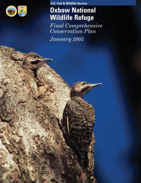
Cover photo: Northern Flickers © Bruce Flaig
Table of Contents<br />
Chapter 1: Introduction <strong>and</strong> Background................................................................................ - 1 -<br />
Refuge Overview...................................................................................................................... - 1 -<br />
Purpose <strong>and</strong> Need for a <strong>CCP</strong>................................................................................................. - 3 -<br />
U.S. <strong>Fish</strong> <strong>and</strong> <strong>Wildlife</strong> <strong>Service</strong> Mission ................................................................................ - 4 -<br />
National <strong>Wildlife</strong> Refuge System Mission ........................................................................... - 4 -<br />
Laws........................................................................................................................................... - 5 -<br />
National <strong>and</strong> Regional Conservation Plans <strong>and</strong> Initiatives Guiding this <strong>CCP</strong>............... - 6 -<br />
Gulf of Maine - Ecosystem Priorities................................................................................ - 6 -<br />
North American Waterfowl Management Plan .............................................................. - 6 -<br />
Partners in Flight Bird Conservation Plans.................................................................... - 8 -<br />
Regional Wetl<strong>and</strong>s Concept Plan- Emergency Wetl<strong>and</strong>s Resources Act................... - 9 -<br />
Our Irreplaceable Heritage - Protecting Biodiversity in Massachusetts, 1998 ....... - 10 -<br />
Existing Partnerships....................................................................................................... - 10 -<br />
Chapter 2: The Comprehensive Conservation Planning Process....................................... - 11 -<br />
Wilderness Assessment ........................................................................................................ - 12 -<br />
Issues, Concerns, <strong>and</strong> Opportunities .................................................................................. - 13 -<br />
Issues <strong>and</strong> Concerns Considered Outside the Scope of This Plan ................................. - 14 -<br />
Chapter 3: Refuge <strong>and</strong> Resource Descriptions ..................................................................... - 17 -<br />
Socioeconomic Setting........................................................................................................... - 17 -<br />
Refuge Resources.................................................................................................................. - 18 -<br />
Climate ................................................................................................................................ - 18 -<br />
Geology <strong>and</strong> Topography.................................................................................................. - 18 -<br />
Soils...................................................................................................................................... - 19 -<br />
Hydrology ........................................................................................................................... - 20 -<br />
Groundwater Resources ................................................................................................... - 21 -<br />
Floodplains ......................................................................................................................... - 22 -<br />
Air Quality .......................................................................................................................... - 22 -<br />
Water Quality <strong>and</strong> Quantity............................................................................................. - 23 -<br />
Biological Resources ............................................................................................................. - 25 -<br />
Vegetation <strong>and</strong> Habitat Types......................................................................................... - 25 -<br />
Invasive or Overabundant Species.................................................................................. - 30 -<br />
<strong>Wildlife</strong> Resources................................................................................................................. - 31 -<br />
Migratory Birds................................................................................................................. - 31 -<br />
Mammals............................................................................................................................. - 32 -<br />
Reptiles <strong>and</strong> Amphibians.................................................................................................. - 32 -<br />
<strong>Fish</strong> ...................................................................................................................................... - 33 -<br />
Invertebrates...................................................................................................................... - 34 -<br />
Threatened <strong>and</strong> Endangered Species................................................................................. - 34 -<br />
Rare Vertebrate Species .................................................................................................. - 34 -<br />
Rare Plant Species ............................................................................................................ - 35 -<br />
Special Designations ............................................................................................................. - 37 -<br />
Cultural Resources................................................................................................................ - 38 -<br />
Prehistoric Period.............................................................................................................. - 38 -<br />
Historic Period................................................................................................................... - 41 -<br />
Socio-economic Resources.................................................................................................... - 48 -<br />
Chapter 4: Management Direction.......................................................................................... - 51 -<br />
Complex Vision ...................................................................................................................... - 51 -
Complex Goals........................................................................................................................ - 51 -<br />
General Refuge Management .............................................................................................. - 66 -<br />
Refuge Access <strong>and</strong> Fees ................................................................................................... - 66 -<br />
Accessibility........................................................................................................................ - 67 -<br />
Non-<strong>Wildlife</strong> Dependent Public Uses............................................................................. - 68 -<br />
Fire Management .............................................................................................................. - 68 -<br />
L<strong>and</strong> Protection ................................................................................................................. - 69 -<br />
Resource Protection <strong>and</strong> Visitor Safety......................................................................... - 70 -<br />
Special Use Permits <strong>and</strong> Memor<strong>and</strong>um of Underst<strong>and</strong>ing <strong>and</strong> Agreement ............ - 70 -<br />
Research ............................................................................................................................. - 71 -<br />
Chapter 5: Refuge Administration.......................................................................................... - 73 -<br />
Refuge Staffing ...................................................................................................................... - 73 -<br />
Refuge Funding ..................................................................................................................... - 73 -<br />
Refuge Buildings <strong>and</strong> Facilities........................................................................................... - 74 -<br />
Step-Down Management Plans ........................................................................................... - 75 -<br />
Maintaining Existing Facilities ........................................................................................... - 75 -<br />
Compatibility Determinations ............................................................................................. - 76 -<br />
Monitoring <strong>and</strong> Evaluation .................................................................................................. - 77 -<br />
Adaptive Management.......................................................................................................... - 78 -<br />
Additional NEPA Analysis................................................................................................... - 78 -<br />
Plan Amendment <strong>and</strong> Revision............................................................................................ - 79 -<br />
Literature Cited......................................................................................................................... - 80 -<br />
Glossary....................................................................................................................................... - 86 -<br />
List of Preparers........................................................................................................................ - 96 -<br />
Appendices.................................................................................................................................. - 98 -<br />
Appendix A: Relevant Laws................................................................................................... - 100 -<br />
Appendix B: U.S. Forest <strong>Service</strong> Content Analysis Team Summary Report ................ - 163 -<br />
Appendix C: Responses to Substantive Comments............................................................ - 161 -<br />
Appendix D: Species Lists...................................................................................................... - 175 -<br />
Appendix E: RONS <strong>and</strong> MMS............................................................................................... - 203 -<br />
Appendix F: Eastern Massachusetts National <strong>Wildlife</strong> Refuge Complex Staffing Chart- 207 -<br />
Appendix G: <strong>Final</strong> Compatibility Determinations .............................................................. - 211 -<br />
Appendix H: Draft Water Quality Report .......................................................................... - 242 -<br />
List of Tables<br />
Table 1-1: NAWMP Species Occurring at <strong>Oxbow</strong> <strong>NWR</strong> ..................................................- 6 -<br />
Table 1-2: Bird Species of Concern Occurring on <strong>Oxbow</strong> <strong>NWR</strong>......................................- 9 -<br />
Table 3-1: Revenue Sharing Payments for Towns Associated with <strong>Oxbow</strong> <strong>NWR</strong>......- 17 -<br />
Table 3-2: <strong>Oxbow</strong> Pond Vegetation Communities............................................................- 29 -<br />
Table 4-1: 2004 Massachusetts Hunting Seasons.............................................................- 63 -<br />
Table D-1: Birds at <strong>Oxbow</strong> <strong>NWR</strong> ......................................................................................- 175 -<br />
Table D-2: Mammals at <strong>Oxbow</strong> <strong>NWR</strong>...............................................................................- 176 -<br />
Table D-3: Reptiles at Great Meadows <strong>NWR</strong>..................................................................- 178 -<br />
Table D-4: Amphibians at <strong>Oxbow</strong> <strong>NWR</strong>...........................................................................- 178 -<br />
Table D-5: Moths at <strong>Oxbow</strong> <strong>NWR</strong>.....................................................................................- 179 -<br />
Table D-6: Butterflies at <strong>Oxbow</strong> <strong>NWR</strong>.............................................................................- 186 -<br />
Table D-7: Dragonflies <strong>and</strong> Damselflies at <strong>Oxbow</strong> <strong>NWR</strong> ..............................................- 187 -
Table D-8: Insects at <strong>Oxbow</strong> <strong>NWR</strong> ...................................................................................- 188 -<br />
Table D-9: Freshwater Mollusks at <strong>Oxbow</strong> <strong>NWR</strong> .........................................................- 189 -<br />
Table D-10: Vascular Plants at <strong>Oxbow</strong> <strong>NWR</strong> ....................................................................- 189 -<br />
Table E-1: Projects currently in the RONS database <strong>and</strong> proposed projects to be<br />
included for <strong>Oxbow</strong> <strong>NWR</strong>...............................................................................................- 203 -<br />
Table E-2: Projects currently backlogged in the MMS for <strong>Oxbow</strong> <strong>NWR</strong>...................- 205 -<br />
Table E-3: Projects currently backlogged in the MMS for the Eastern Massachusetts<br />
Refuge Complex...............................................................................................................- 205 -<br />
List of Figures<br />
Map 1-1: Eastern Massachusetts National <strong>Wildlife</strong> Refuge Complex.................................- 2 -<br />
Map 1-2: Gulf of Maine Rivers Ecosystem...............................................................................- 7 -<br />
Map 3-1: Forest <strong>and</strong> L<strong>and</strong> Cover Types (Area 1A Fort Devens).......................................- 26 -<br />
Map 3-2: Forest <strong>and</strong> L<strong>and</strong> Cover Types (Area 1 Fort Devens)..........................................- 26 -<br />
Map 3-3: Forest <strong>and</strong> L<strong>and</strong> Cover Types (Areas 2, 3, <strong>and</strong> Airfield Fort Devens).............- 27 -<br />
Map 4-1: Public Use at <strong>Oxbow</strong> <strong>NWR</strong>......................................................................................- 58 -<br />
Map 4-2: Current <strong>and</strong> Future Hunting Areas on <strong>Oxbow</strong> <strong>NWR</strong> .........................................- 61 -
<strong>Oxbow</strong> <strong>NWR</strong>: USFWS photo<br />
Chapter 1: Introduction <strong>and</strong> Background<br />
Chapter 1: Introduction <strong>and</strong> Background<br />
This <strong>Final</strong> Comprehensive Conservation Plan (<strong>CCP</strong>) has been prepared for<br />
the <strong>Oxbow</strong> National <strong>Wildlife</strong> Refuge (<strong>NWR</strong>), which is one of eight refuges<br />
of the Eastern Massachusetts <strong>NWR</strong> Complex (Complex) (see Map 1-1).<br />
Concurrently, we are releasing the <strong>Final</strong> <strong>CCP</strong>s for Great Meadows<br />
(Concord <strong>and</strong> Sudbury Divisions), <strong>and</strong> Assabet River <strong>NWR</strong>s.<br />
We will prepare a separate <strong>CCP</strong> <strong>and</strong> Environmental Impact Statement<br />
(<strong>CCP</strong>/EIS) for Monomoy <strong>and</strong> Nomans L<strong>and</strong> Isl<strong>and</strong> <strong>NWR</strong>s beginning later<br />
in 2004. We propose to begin the <strong>CCP</strong> process for Massasoit <strong>NWR</strong> in 2005<br />
<strong>and</strong> Nantucket <strong>and</strong> Mashpee <strong>NWR</strong>s in 2006.<br />
This <strong>CCP</strong> is the culmination of a planning process that began in January<br />
1999. Numerous meetings with the public, the state, <strong>and</strong> conservation<br />
partners were held to identify <strong>and</strong> evaluate management alternatives. A<br />
draft <strong>CCP</strong> <strong>and</strong> Environmental Assessment (<strong>CCP</strong>/EA) was distributed in<br />
July 2003. This <strong>CCP</strong> presents the management goals, objectives, <strong>and</strong><br />
strategies that we believe will best achieve our vision for the refuge,<br />
contribute to the National <strong>Wildlife</strong> Refuge System (Refuge System)<br />
Mission, achieve refuge purposes <strong>and</strong> legal m<strong>and</strong>ates, <strong>and</strong> serve the<br />
American public.<br />
Refuge Overview<br />
The refuge is located in north-central Massachusetts, approximately 35<br />
miles northwest of Boston, MA. The refuge lies within the towns of Ayer<br />
<strong>and</strong> Shirley in Middlesex County <strong>and</strong> the towns of Harvard <strong>and</strong> Lancaster<br />
in Worcester County. The refuge consists of approximately 1,667 acres of<br />
upl<strong>and</strong>, southern New Engl<strong>and</strong> floodplain forest <strong>and</strong> wetl<strong>and</strong> communities<br />
along nearly 8 miles of the Nashua River corridor.<br />
The refuge is a long, narrow parcel with a north/south orientation.<br />
Roadways running east/west divide the parcel into three sections.<br />
The northern end of the refuge abuts the former Fort Devens,<br />
Moore Army Airfield just south of Massachusetts Route 2A. Shirley<br />
Road/West Main Street in Ayer separates the northern <strong>and</strong> middle<br />
portions of the refuge. Massachusetts Route 2 bisects the middle<br />
<strong>and</strong> southern parcels. The refuge’s southern boundary is at Still<br />
River Depot Road in Harvard, MA.<br />
The refuge was formed by three l<strong>and</strong> transfers from the former<br />
U.S. Army, Fort Devens Military Installation, <strong>and</strong> a recent<br />
purchase of private l<strong>and</strong> in Harvard, MA. Two of the transfers from<br />
Comprehensive Conservation Plan<br />
- 1 -
- 2 -<br />
Chapter 1: Introduction <strong>and</strong> Background<br />
Map 1-1: Eastern Massachusetts National <strong>Wildlife</strong> Refuge Complex<br />
<strong>Oxbow</strong> National <strong>Wildlife</strong> Refuge
Chapter 1: Introduction <strong>and</strong> Background<br />
the Army (May, 1974 <strong>and</strong> February, 1988) formed the original 711.03 acre<br />
portion of the refuge located south of Massachusetts Route 2. The third<br />
Army transfer occurred in May of 1999, <strong>and</strong> added the 836.3 acre portion of<br />
the refuge that is located north of Route 2. <strong>Final</strong>ly, approximately 120<br />
acres was added to the refuge in April, 2001, with the acquisition of the<br />
former Watt Farm property along Still River Depot Road in Harvard.<br />
The primary purpose for which the refuge was created is its “...particular<br />
value in carrying out the National Migratory Bird Management Program”<br />
(16 U.S.C. 667B, An Act Authorizing the Transfer of Certain Real Property<br />
for <strong>Wildlife</strong>, or Other Purposes, as amended). The refuge’s interspersion of<br />
wetl<strong>and</strong>, forested upl<strong>and</strong> <strong>and</strong> old field habitats is ideally suited for this<br />
purpose. The refuge supports a diverse mix of migratory birds including<br />
waterfowl, wading birds, raptors, shorebirds, passerines, as well as resident<br />
mammals, reptiles, amphibians, fish <strong>and</strong> invertebrates. The extensive <strong>and</strong><br />
regionally significant wetl<strong>and</strong>s occurring on <strong>and</strong> adjacent to the refuge,<br />
including their associated tributary drainages <strong>and</strong> headwaters, have been<br />
listed as a priority for protection under both the North American<br />
Waterfowl Management Plan (NAWMP) <strong>and</strong> the Emergency Wetl<strong>and</strong>s<br />
Resources Act of 1986.<br />
The portion of the refuge south of Route 2 lies within the 12,900 acre<br />
Central Nashua River Valley Area of Critical Environmental Concern<br />
(ACEC) designated by the Massachusetts Secretary of Environmental<br />
Affairs due to its unique environmental characteristics <strong>and</strong> values (MADEP<br />
1998). The refuge’s geographic position, accessibility to the local <strong>and</strong><br />
regional communities, <strong>and</strong> its diverse biological resources also makes it<br />
highly attractive for natural resource educational or interpretive programs,<br />
<strong>and</strong> compatible wildlife dependent recreational uses. An estimated 70,000<br />
people visited the refuge in 2003. All of this use occurred within the older<br />
portion of the refuge, south of Route 2.<br />
Purpose <strong>and</strong> Need for a <strong>CCP</strong><br />
The purpose of a <strong>CCP</strong> is to provide managers <strong>and</strong> other interested partners<br />
guidance <strong>and</strong> direction for each refuge over the next 15 years, thus<br />
achieving refuge purposes <strong>and</strong> contributing to the mission of the Refuge<br />
System. The plan identifies what role the refuges play, consistent with<br />
sound principles of fish <strong>and</strong> wildlife conservation, in the protection,<br />
enhancement <strong>and</strong> restoration of trust resources.<br />
This plan is also needed to:<br />
• provide a clear statement of desired future conditions for habitat,<br />
wildlife, visitors <strong>and</strong> facilities;<br />
• provide refuge neighbors, visitors, <strong>and</strong> partners with a clear<br />
underst<strong>and</strong>ing of the reasons for management actions;<br />
• ensure management reflects the policies <strong>and</strong> goals of the Refuge<br />
System <strong>and</strong> legal m<strong>and</strong>ates;<br />
Comprehensive Conservation Plan<br />
- 3 -
- 4 -<br />
“To administer a national<br />
network of l<strong>and</strong>s <strong>and</strong> waters<br />
for the conservation,<br />
management, <strong>and</strong> where<br />
appropriate, restoration of<br />
the fish, wildlife, <strong>and</strong> plant<br />
resources <strong>and</strong> their habitats<br />
within the United States for<br />
the benefit of present <strong>and</strong><br />
future generations of<br />
Americans.” (Refuge<br />
Improvement Act; Public<br />
Law 105-57)–Mission of the<br />
Refuge System.<br />
Chapter 1: Introduction <strong>and</strong> Background<br />
• ensure the compatibility of current <strong>and</strong> future uses;<br />
• review current boundaries of the refuges, <strong>and</strong> evaluate the need to<br />
revise boundaries to better achieve refuge purposes;<br />
• provide long-term continuity <strong>and</strong> direction for refuge management;<br />
<strong>and</strong>,<br />
• provide a basis for staffing <strong>and</strong> operations, maintenance, <strong>and</strong> the<br />
development of budget requests.<br />
Currently, there is no management plan in place for the refuge that<br />
establishes priorities or provides consistent direction for managing fish,<br />
wildlife, habitats, <strong>and</strong> public uses on these refuges. This plan will help to<br />
resolve issues related to control of nuisance <strong>and</strong> invasive species, public<br />
uses in conflict with wildlife needs, lack of opportunities for wildlife<br />
dependent recreation, <strong>and</strong> the needs of our federal trust wildlife species.<br />
U.S. <strong>Fish</strong> <strong>and</strong> <strong>Wildlife</strong> <strong>Service</strong> Mission<br />
The Refuge System is managed by the U.S. <strong>Fish</strong> <strong>and</strong> <strong>Wildlife</strong> <strong>Service</strong><br />
(<strong>Service</strong>) under the Department of Interior. The mission of the <strong>Service</strong> is:<br />
“...working with others to conserve, protect, <strong>and</strong> enhance fish, wildlife, <strong>and</strong><br />
plants <strong>and</strong> their habitats for the continuing benefit of the American<br />
people.”<br />
The <strong>Service</strong> manages <strong>NWR</strong>s, waterfowl protection areas, <strong>and</strong> National<br />
<strong>Fish</strong> Hatcheries. By law, Congress entrusts the following federal trust<br />
resources to the <strong>Service</strong> for conservation <strong>and</strong> protection: migratory birds<br />
<strong>and</strong> fish, endangered species, interjurisdictional fish, <strong>and</strong> certain marine<br />
mammals. The <strong>Service</strong> also enforces federal wildlife laws <strong>and</strong> international<br />
treaties on importing <strong>and</strong> exporting wildlife, assists with state fish <strong>and</strong><br />
wildlife programs, <strong>and</strong> helps other countries develop wildlife conservation<br />
programs.<br />
National <strong>Wildlife</strong> Refuge System Mission<br />
The Refuge System is the world’s largest collection of l<strong>and</strong>s <strong>and</strong><br />
waters set aside specifically for the conservation of wildlife <strong>and</strong><br />
ecosystem protection. The Refuge System consists of 544<br />
national wildlife refuges that provide important habitat for<br />
native plants <strong>and</strong> many species of mammals, birds, fish,<br />
invertebrates, <strong>and</strong> threatened <strong>and</strong> endangered species,<br />
encompassing over 95 million acres. Refuges offer a wide<br />
variety of recreational opportunities, <strong>and</strong> many have visitor<br />
centers, wildlife trails, <strong>and</strong> environmental education programs.<br />
Nationwide, over 34 million visitors annually hunt, fish, observe<br />
<strong>and</strong> photograph wildlife, or participate in interpretive activities<br />
on <strong>NWR</strong>s.<br />
<strong>Oxbow</strong> National <strong>Wildlife</strong> Refuge
Beaver activity: Photo by Marijke<br />
Holtrop<br />
Chapter 1: Introduction <strong>and</strong> Background<br />
In 1997, the National <strong>Wildlife</strong> Refuge Improvement Act (Refuge<br />
Improvement Act) established a unifying mission for the Refuge System, a<br />
new process for determining compatible public uses, <strong>and</strong> the requirement<br />
to prepare a <strong>CCP</strong> for each refuge. The new law states that the Refuge<br />
System must focus on wildlife conservation. It further states that the<br />
National mission, coupled with the purpose(s) for which each refuge was<br />
established, will provide the principal management direction for each<br />
refuge.<br />
Laws<br />
While the Refuge System mission <strong>and</strong> each refuge’s purpose provide the<br />
foundation for management, <strong>NWR</strong>s are also governed by other federal<br />
laws, executive orders, treaties, interstate compacts, <strong>and</strong> regulations<br />
pertaining to the conservation <strong>and</strong> protection of natural <strong>and</strong> cultural<br />
resources (see appendix A for a more complete list of guiding laws).<br />
A primary law affecting refuge management is the National <strong>Wildlife</strong><br />
Refuge System Administration Act of 1966 (Administration Act) which<br />
authorizes the Secretary of the Interior to permit any uses of a refuge<br />
“...whenever it is determined that such uses are compatible with the major<br />
purposes for which such areas were established.” The Administration Act<br />
was amended by the Refuge Improvement Act. It is also the key legislation<br />
on managing public uses, <strong>and</strong> protecting the Refuge System from<br />
incompatible or harmful human activities to insure that Americans can<br />
enjoy Refuge System l<strong>and</strong>s <strong>and</strong> waters.<br />
Additionally, it is <strong>Service</strong> policy to address how each refuge, with an<br />
approved <strong>CCP</strong>, can help achieve the goals of the National Wilderness<br />
Preservation system. Thus, concurrent with the <strong>CCP</strong> process, we<br />
have incorporated a summary of a wilderness assessment into this<br />
document (see Wilderness Assessment section).<br />
The Refuge Recreation Act of 1962 requires that any recreational use<br />
of refuge l<strong>and</strong>s be compatible with the primary purposes for which a<br />
refuge was established <strong>and</strong> not inconsistent with other previously<br />
authorized operations.<br />
The National Historic Preservation act of 1966 provides for the<br />
management of historic <strong>and</strong> archaeological resources that occur on any<br />
refuge. Other legislation, such as the Endangered Species Act, the North<br />
American Wetl<strong>and</strong>s Conservation Act (NAWCA), the Wilderness Act of<br />
1964 <strong>and</strong> particularly the National Environmental Policy Act (NEPA) all<br />
provide guidance for the conservation of fish <strong>and</strong> wildlife <strong>and</strong> their habitats.<br />
Comprehensive Conservation Plan<br />
- 5 -
Wood Duck: Photo by Bruce Flaig<br />
- 6 -<br />
Chapter 1: Introduction <strong>and</strong> Background<br />
National <strong>and</strong> Regional Conservation Plans <strong>and</strong> Initiatives Guiding<br />
this <strong>CCP</strong><br />
Gulf of Maine - Ecosystem Priorities<br />
There are 52 ecosystem teams across the country. The refuge is located in<br />
the Gulf of Maine ecosystem (see Map 1-2). The ecosystem priorities that<br />
are applicable to the refuge are:<br />
• Recover populations <strong>and</strong> habitats of endangered <strong>and</strong> threatened<br />
species.<br />
• Protect, enhance, <strong>and</strong> restore coastal habitats for trust resources of<br />
concern.<br />
• Protect, enhance, <strong>and</strong> restore populations of migratory bird species<br />
of special concern <strong>and</strong> their habitats.<br />
• Manage <strong>Service</strong> l<strong>and</strong>s to protect, enhance <strong>and</strong> restore habitats to<br />
maintain biodiversity.<br />
North American Waterfowl Management Plan<br />
The NAWMP documents the strategy between the United States, Canada<br />
<strong>and</strong> Mexico to restore waterfowl populations through habitat protection,<br />
restoration, <strong>and</strong> enhancement. Implementation of the plan is at the regional<br />
level. Ten regional habitat “joint ventures” are partnerships involving<br />
federal, state, provincial, tribal nations, local businesses, conservation<br />
organizations, <strong>and</strong> individual citizens. Units of the Complex are contained<br />
within the Atlantic Coast Joint Venture.<br />
The Atlantic Coast Joint Venture Program identifies seven focus areas in<br />
Massachusetts. One of these focus areas includes the inl<strong>and</strong> rivers of the<br />
Blackstone, Nashua, <strong>and</strong> the Sudbury-Assabet-Concord Rivers.<br />
<strong>Oxbow</strong> <strong>NWR</strong> is part of this focus area, with nationally significant<br />
wetl<strong>and</strong>s that support migrating waterfowl. The Program is<br />
developing a focus area report that identifies important waterfowl<br />
resources, threats, <strong>and</strong> conservation recommendations.<br />
A draft updated NAWMP document is at:<br />
http://birdhabitat.fws.gov/NAWMP/2003nawmpdraft.htm. In the<br />
Implementation Framework section of this document species<br />
priorities are listed for each region. Table 1-1 includes species<br />
identified in the NAWMP that occur at <strong>Oxbow</strong> <strong>NWR</strong>.<br />
Table 1-1: NAWMP Species Occurring at <strong>Oxbow</strong> <strong>NWR</strong><br />
Species Continental Breeding Breeding Nonbreeding Nonbreeding<br />
Priority Importance Need Importance Need<br />
American Black Duck High Mod. High High High Highest<br />
Mallard High Mod. Low Moderate Mod. High High<br />
Green-winged Teal Moderate Mod. Low Mod. Low<br />
Wood Duck Moderate Mod. Low Mod. Low Mod. Low Mod. Low<br />
<strong>Oxbow</strong> National <strong>Wildlife</strong> Refuge
Map 1-2: Gulf of Maine Rivers Ecosystem<br />
Comprehensive Conservation Plan<br />
Chapter 1: Introduction <strong>and</strong> Background<br />
- 7 -
- 8 -<br />
Chapter 1: Introduction <strong>and</strong> Background<br />
Partners in Flight Bird Conservation Plans<br />
Partners in Flight (PIF) was initiated in 1990 as a voluntary, international<br />
coalition of agencies, organizations, institutions, industries, <strong>and</strong> other<br />
citizens dedicated to l<strong>and</strong>bird conservation. The foundation for PIF’s<br />
long-term strategy for bird conservation is a series of scientifically<br />
based bird conservation plans. The goal of each PIF bird<br />
conservation plan is to ensure long-term maintenance of healthy<br />
populations of native l<strong>and</strong>birds. These plans use information on bird<br />
population trends, species’ distributions, <strong>and</strong> the vulnerability of the<br />
species <strong>and</strong> their habitats to threats, to rank the conservation<br />
priority of birds occurring within a particular physiographic area.<br />
The PIF approach differs from many existing federal <strong>and</strong><br />
state-level listing processes in that it (1) is voluntary <strong>and</strong> nonregulatory,<br />
<strong>and</strong> (2) focuses proactively on relatively common species<br />
American Goldfinch: Photo by S<strong>and</strong>y in areas where conservation actions can be most effective, rather<br />
Selesky<br />
than local emphasis on rare <strong>and</strong> peripheral populations. A<br />
L<strong>and</strong>bird Conservation Plan for the southern New Engl<strong>and</strong><br />
physiographic area was completed in 2000, which includes all of eastern<br />
Massachusetts. This plan identifies 72 priority breeding bird species, 9<br />
priority winter species, <strong>and</strong> 7 major habitat types as priorities for<br />
conservation in this area. Of the priority species for this physiographic<br />
area, at least 21 of the priority breeding species have been recorded as<br />
occurring on the refuge <strong>and</strong> 1 of the 9 wintering species have been recorded<br />
as wintering on the refuge. In the plan, focal species are selected for each<br />
habitat type <strong>and</strong> used in developing population <strong>and</strong> habitat objectives.<br />
Implementation strategies <strong>and</strong> management guidelines for achieving these<br />
objectives are also included for each habitat type. Priority habitats for<br />
southern New Engl<strong>and</strong> include maritime marshes, beaches/dunes, mature<br />
forest, early successional scrub/pine barrens, freshwater wetl<strong>and</strong>s, <strong>and</strong><br />
grassl<strong>and</strong>s. The list of priority species, objectives, <strong>and</strong> conservation actions<br />
recommended in the southern New Engl<strong>and</strong> Bird Conservation Plan will<br />
help direct l<strong>and</strong>bird management on the refuge.<br />
The North Atlantic Regional Shorebird Plan (NARSP), developed in 2001,<br />
identifies 38 priority shorebird species based upon a national scoring<br />
system that assesses population trends, relative abundance, threats <strong>and</strong><br />
distribution patterns. The <strong>Service</strong> has recorded 4 of these species as<br />
occurring on the refuge. The NARSP builds upon the information in the<br />
U.S. Shorebird Conservation Plan (USSCP). The USSCP is a partnership<br />
involving organizations throughout the United States committed to the<br />
conservation of shorebirds. At a regional scale, the goal of the USSCP is to<br />
ensure that adequate quantity <strong>and</strong> quality of habitat is identified <strong>and</strong><br />
maintained to support the different shorebirds that breed in, winter in, <strong>and</strong><br />
migrate through each region. In August 2004, the USSCP was revised<br />
<strong>Oxbow</strong> National <strong>Wildlife</strong> Refuge
Chapter 1: Introduction <strong>and</strong> Background<br />
based upon the latest population <strong>and</strong> habitat information available. The<br />
revised list included 7 highly imperiled shorebird taxa <strong>and</strong> 23 taxa of high<br />
concern. The refuge supports 2 species of shorebirds of high concern.<br />
Additionally, the <strong>Service</strong> has attempted to assess <strong>and</strong> integrate all the<br />
information above <strong>and</strong> compile a list of Birds of Conservation Concern for<br />
Bird Conservation Region 30, which contains the refuge. There are a total<br />
of 32 species listed, 6 of these have been recorded as occurring on the<br />
refuge.<br />
Table 1-2: Bird Species of Concern Occurring on <strong>Oxbow</strong> <strong>NWR</strong><br />
PIF BCR 30 NARSP USSCP<br />
Species Priority Wintering Conservation Priority High<br />
Breeding<br />
Concerns Shorebird Concern<br />
Blue-winged warbler � �<br />
Wood Thrush � �<br />
Baltimore Oriole<br />
Scarlet Tanager<br />
� �<br />
American Woodcock � � �<br />
Rose-breasted<br />
Grosbeak<br />
�<br />
Chimney Swift �<br />
Eastern Woodpewee<br />
�<br />
Black-<strong>and</strong>-white<br />
Warbler<br />
�<br />
Hairy Woodpecker �<br />
Eastern Towhee �<br />
Purple Finch �<br />
American Black<br />
Duck<br />
� �<br />
Canada Warbler � �<br />
Whip-poor-will � �<br />
Sharp-shinned Hawk �<br />
Pied-billed Grebe �<br />
Short-eared Owl � �<br />
Osprey �<br />
Great Blue Heron �<br />
Killdeer �<br />
Solitary S<strong>and</strong>piper � �<br />
Spotted S<strong>and</strong>piper �<br />
Least S<strong>and</strong>piper �<br />
Regional Wetl<strong>and</strong>s Concept Plan- Emergency Wetl<strong>and</strong>s Resources Act<br />
In 1986, Congress enacted the Emergency Wetl<strong>and</strong>s Resources Act to<br />
promote the conservation of our nation’s wetl<strong>and</strong>s. This Act requires<br />
identification of the location <strong>and</strong> types of wetl<strong>and</strong>s, <strong>and</strong> which l<strong>and</strong>s should<br />
be targeted for state <strong>and</strong> federal l<strong>and</strong> acquisition efforts. In 1990, the<br />
Northeast Regional Office of the <strong>Service</strong> completed a Regional Wetl<strong>and</strong>s<br />
Comprehensive Conservation Plan<br />
- 9 -
The Nashua River: Staff Photo<br />
- 10 -<br />
Chapter 1: Introduction <strong>and</strong> Background<br />
Concept Plan to identify wetl<strong>and</strong>s in the region. The Regional Plan<br />
identifies a total of 850 wetl<strong>and</strong> sites <strong>and</strong> complexes in the region, two of<br />
them are within the Complex acquisition boundary. 2,000 acres of wetl<strong>and</strong>s<br />
associated with the Nashua River were identified as being regionally<br />
valuable for wildlife, fisheries, recreation <strong>and</strong> water quality, quantity <strong>and</strong><br />
flood control.<br />
Our Irreplaceable Heritage - Protecting Biodiversity in Massachusetts,<br />
1998<br />
This report recommends that the State develop a biodiversity protection<br />
strategy that outlines how all native biodiversity will be conserved. It also<br />
identifies <strong>and</strong> describes eight types of natural communities that may<br />
require immediate conservation attention because of their potential<br />
vulnerability <strong>and</strong> large number of rare species they contain. Seven of the<br />
eight communities listed in the report occur within the Complex boundary.<br />
Existing Partnerships<br />
Throughout this <strong>CCP</strong>, we use the term “partners”. In addition to our<br />
volunteers, we receive significant help from the following partners:<br />
Freedom’s Way Heritage Association<br />
Friends of the <strong>Oxbow</strong> <strong>NWR</strong><br />
Harvard Conservation Trust<br />
Massachusetts Department of <strong>Fish</strong> <strong>and</strong> Game (DFG), Division of<br />
<strong>Fish</strong>eries <strong>and</strong> <strong>Wildlife</strong> (Mass<strong>Wildlife</strong>)<br />
Nashua River Watershed Association<br />
<strong>Oxbow</strong> Associates<br />
The Trust for Public L<strong>and</strong><br />
The Friends of the <strong>Oxbow</strong> <strong>NWR</strong> provide considerable time <strong>and</strong><br />
effort toward accomplishment of refuge <strong>and</strong> <strong>Service</strong> goals. They<br />
participate in projects that lead to: l<strong>and</strong> protection/acquisition,<br />
environmental education <strong>and</strong> outreach, provision of public use<br />
opportunities, such as guided interpretive walks, trail maintenance <strong>and</strong><br />
kiosk maintenance/supplies, <strong>and</strong> meeting biological goals, such as assisting<br />
with surveys <strong>and</strong> habitat restoration. During fiscal year 2003, Friends of<br />
the <strong>Oxbow</strong> <strong>NWR</strong> contributed 1,301 hours of volunteer time on the refuge.<br />
<strong>Oxbow</strong> National <strong>Wildlife</strong> Refuge
Chapter 2: The Comprehensive Conservation Planning Process<br />
Chapter 2: The Comprehensive Conservation Planning<br />
Process<br />
Given the m<strong>and</strong>ate in the Refuge Improvement Act to develop a <strong>CCP</strong> for<br />
each <strong>NWR</strong>, we began the planning process in 1999. We started by forming<br />
a core planning team of refuge staff <strong>and</strong> <strong>Service</strong> planners from the regional<br />
office. We placed a Notice of Intent to prepare an EIS in the January 1999<br />
Federal Register to officially kick-off our planning effort for all eight of the<br />
Complex refuges.<br />
First, we collected information on our biological <strong>and</strong> habitat resources.<br />
While in the process of collecting information, we initiated the public<br />
scoping <strong>and</strong> involvement part of the process. We held meetings with each<br />
town’s Board of Selectmen <strong>and</strong> state <strong>and</strong> federal agencies. Many of these<br />
groups provided information on natural resources <strong>and</strong> public uses on<br />
refuges in the Complex. In February of 1999,<br />
we held open houses in central locations to<br />
provide an opportunity for public comment<br />
on different issues including current <strong>and</strong><br />
future management strategies, l<strong>and</strong><br />
protection <strong>and</strong> public uses. We were pleased<br />
with the participation at many of our<br />
meetings, which ranged from 30 people to<br />
over 100.<br />
We recognized that attending our open<br />
houses would be difficult for many <strong>and</strong><br />
designed an Issues Workbook to encourage<br />
additional comment. Over 8,000 people<br />
representing a variety of interests received<br />
workbooks. Workbooks were also available<br />
at open houses <strong>and</strong> at the refuge<br />
headquarters. We received over 660<br />
responses.<br />
Using the information collected from our<br />
partners <strong>and</strong> through public comment we<br />
identified significant issues to be addressed in the plan. In August of 1999,<br />
we distributed a Planning Update to everyone on our mailing list<br />
describing the key issues identified for each refuge.<br />
Once key issues were determined <strong>and</strong> refined, we developed alternative<br />
strategies to address each one. We derived the strategies from public<br />
comment, follow-up contacts with partners <strong>and</strong> refuge staff. After a<br />
reasonable range of alternatives was identified, we evaluated the<br />
environmental consequences of each alternative.<br />
Comprehensive Conservation Plan<br />
- 11 -
- 12 -<br />
Wild Indigo: Photo by Marijke Holtrop<br />
Chapter 2: The Comprehensive Conservation Planning Process<br />
In February of 2001 we recognized that producing a <strong>CCP</strong>/EIS for the<br />
entire Complex would be far too cumbersome to be efficient. At that time,<br />
we published a Notice of Intent to prepare a <strong>CCP</strong>/EA for five of the refuges<br />
in the Complex; Assabet River, Great Meadows, <strong>Oxbow</strong>, Mashpee <strong>and</strong><br />
Massasoit <strong>NWR</strong>s. Additional issues <strong>and</strong> a need for more information<br />
prompted us to later split Mashpee <strong>and</strong> Massasoit <strong>NWR</strong>s from this draft as<br />
well.<br />
The <strong>Service</strong> solicited comments on the draft <strong>CCP</strong>/EA for Great Meadows,<br />
Assabet River, <strong>and</strong> <strong>Oxbow</strong> <strong>NWR</strong>s from July 20 to September 3, 2003. We<br />
contracted with the U.S. Forest <strong>Service</strong>’s Content Analysis Team (CAT) to<br />
compile the nearly 2,000 comments that we received. The CAT developed a<br />
summary report of comments (Appendix B) as well as a database of<br />
individual comments. We utilized the CAT report <strong>and</strong> comment database<br />
to develop a list of substantive comments that required<br />
responses. Editorial suggestions, along with general<br />
notes of concurrence with or opposition to certain<br />
proposals that did not contain factual arguments<br />
were<br />
noted <strong>and</strong> included in the decision making process, but<br />
do not receive formal responses. We have included<br />
our responses to requests for additional information<br />
or<br />
clarification, provisions of additional information, <strong>and</strong><br />
specific concerns as Appendix C. We have made<br />
changes to the <strong>CCP</strong> where appropriate.<br />
The<br />
final product of the process is three st<strong>and</strong>-alone<br />
<strong>CCP</strong>s, one for each refuge. Implementation of the <strong>CCP</strong> can occur once the<br />
Finding of (No) Significant Impact (FONSI) is signed.<br />
We<br />
will evaluate our accomplishments under the <strong>CCP</strong>, each year.<br />
Monitoring or new information may indicate the need to change our<br />
strategies. The collection of additional data at Great Meadows <strong>NWR</strong> will<br />
likely require modification <strong>and</strong> specification of the wildlife <strong>and</strong> habitat<br />
management strategies. We will modify the <strong>CCP</strong> documents <strong>and</strong> associated<br />
management activities as needed; following the procedures outlined in<br />
<strong>Service</strong> policy <strong>and</strong> NEPA requirements. The <strong>CCP</strong>s will be fully revised<br />
every 15 years or sooner if necessary.<br />
Wilderness Assessment<br />
The<br />
planning team conducted a Wilderness Assessment, as required under<br />
the Refuge Planning Policy, to determine if any l<strong>and</strong>s <strong>and</strong> waters in fee title<br />
ownership were suitable to be proposed for designation as a Wilderness<br />
Area. During the inventory stage, we determined that the refuge does not<br />
fulfill the eligibility requirements for a Wilderness Study Area as defined<br />
by the Wilderness Act. The refuge <strong>and</strong> surrounding area has been altered<br />
in some way by man, with the imprint of man’s work generally noticeable.<br />
The area is less than 5,000 contiguous acres, <strong>and</strong> is not of sufficient size as<br />
<strong>Oxbow</strong> National <strong>Wildlife</strong> Refuge
Purple Loosestrife: Photo by<br />
Paul Buckley<br />
Chapter 2: The Comprehensive Conservation Planning Process<br />
to make practicable its preservation <strong>and</strong> use in an unimpaired condition.<br />
Furthermore, permanent roads are contained within most of the areas<br />
studied. Therefore, suitability of the l<strong>and</strong>s for Wilderness Designation is<br />
not analyzed further in this document.<br />
Issues, Concerns, <strong>and</strong> Opportunities<br />
Issues,<br />
concerns, <strong>and</strong> opportunities were brought to the attention of the<br />
refuge planning team through early planning discussions with local<br />
governments, state, <strong>and</strong> federal representatives, <strong>and</strong> through the public<br />
scoping process. We received comments from the public both verbally at<br />
open houses <strong>and</strong> in writing, through Issues Workbooks <strong>and</strong> individual<br />
letters. Some issues were identified by the <strong>Service</strong> <strong>and</strong> others were raised<br />
during the public review of the Draft <strong>CCP</strong>/EA. Many issues that are very<br />
important to the public often fall outside the scope of the decision to be<br />
made within this planning process. In some instances, the <strong>Service</strong> cannot<br />
resolve issues some people have communicated to us. We have considered<br />
all issues throughout our planning process, <strong>and</strong> have developed plans that<br />
attempt to balance the competing opinions regarding important issues.<br />
Habitat<br />
<strong>and</strong> wildlife management<br />
Many<br />
people were interested in our management programs. We have<br />
begun additional surveys <strong>and</strong> inventories to collect baseline information<br />
on<br />
the refuge. Our efforts at these refuges will help us develop a habitat<br />
management plan which will provide a detailed description of our goals<br />
<strong>and</strong> objectives for habitat management on the refuge.<br />
Individuals<br />
<strong>and</strong> groups expressed a great deal of interest in how we<br />
manage Bl<strong>and</strong>ing’s turtles <strong>and</strong> migratory birds <strong>and</strong> upl<strong>and</strong> habitats.<br />
Additionally, interest was expressed in creating an additional wildlife<br />
passage under Route 2 at the refuge.<br />
Control<br />
of invasive, injurious, <strong>and</strong> overabundant plant <strong>and</strong> animal<br />
species<br />
Invasive<br />
species, including common reed <strong>and</strong> purple loosestrife, are a<br />
concern. These species limit the productivity of wildlife habitat.<br />
Management to control invasive species was mentioned as a watershed-<br />
wide priority to some conservation associations. We will continue efforts<br />
to control known invasives on the refuge.<br />
Hunting<br />
Requests<br />
were made at public meetings <strong>and</strong> through written comments<br />
both to allow <strong>and</strong> not to allow deer hunting on the refuge. Currently, the<br />
refuge allows hunting for migratory birds (American woodcock), big game<br />
(turkey), <strong>and</strong> upl<strong>and</strong> game (ruffed grouse, rabbit <strong>and</strong> squirrel). There have<br />
Comprehensive Conservation Plan<br />
- 13 -
- 14 -<br />
Bullfrog: Photo by Ken Andrews<br />
Chapter 2: The Comprehensive Conservation Planning Process<br />
been suggestions to provide additional lawful hunting opportunities on the<br />
refuge to control deer populations <strong>and</strong> deter poaching. Cooperation with<br />
local towns <strong>and</strong> hunting groups was a suggestion. Others oppose hunting<br />
of any kind on the refuge.<br />
Management<br />
of public use <strong>and</strong> access<br />
The<br />
refuge has high visitation numbers. We<br />
estimated use at the refuge to be 70,000 visits in 2003. We do not have a<br />
consistent process for collecting <strong>and</strong> documenting visitation at all sites.<br />
Several non-wildlife dependent recreational activities <strong>and</strong> some<br />
unauthorized activities occur on the refuge. Some visitors use trails at the<br />
refuge for dog walking, jogging <strong>and</strong> illegally for bike riding.<br />
Resource<br />
Protection <strong>and</strong> Visitor Safety<br />
Many<br />
people voiced concern regarding additional protection for cultural<br />
<strong>and</strong> historical resources. Other concerns included the need to control<br />
poaching, trespassing <strong>and</strong> other refuge regulations violations.<br />
Infrastructure<br />
<strong>and</strong> operations <strong>and</strong> maintenance<br />
The<br />
Complex Headquarters <strong>and</strong> Visitor<br />
Contact Station is located in Sudbury, MA.<br />
Residents near <strong>Oxbow</strong> <strong>NWR</strong> are anxious to<br />
have a visitor contact station/education<br />
center closer to their refuge. Many people<br />
requested a visitor center at Fort Devens in<br />
an effort not to build on the refuge itself. The<br />
need for environmental educational<br />
programs in local schools as well as<br />
additional interpretive opportunities where<br />
the public can learn about the refuge was<br />
raised.<br />
We<br />
heard from some people that the Complex doesn’t have the resources<br />
<strong>and</strong> staff needed to support programs <strong>and</strong> maintenance of the refuge.<br />
Issues <strong>and</strong> Concerns Considered Outside the Scope of This Plan<br />
Some<br />
towns wish to develop water supply wells on refuge property.<br />
Some<br />
towns requested access for the purpose of drilling water supply wells.<br />
Wells have been shown to draw down the surrounding water table. A 1994<br />
study by the Massachusetts Office of Water Resources identified that<br />
“wells can have a significant impact on nearby (surface) water bodies <strong>and</strong><br />
may affect specific biological resources.” Concerns were raised by the<br />
<strong>Oxbow</strong> National <strong>Wildlife</strong> Refuge
Chapter 2: The Comprehensive Conservation Planning Process<br />
public during <strong>CCP</strong> scoping that disturbance to wildlife, <strong>and</strong> other impacts<br />
due to the wells, or access to the wells, could occur.<br />
Chemical control of mosquitoes on <strong>NWR</strong>s nationwide is being evaluated<br />
by the <strong>Service</strong>.<br />
The <strong>Service</strong> has developed a draft national mosquito policy for refuge<br />
managers to apply when determining how <strong>and</strong> when mosquito populations<br />
may be managed on l<strong>and</strong>s administered within the Refuge System. The<br />
science-based draft policy indicates that mosquito populations will<br />
essentially be allowed to function unimpeded as part of the wetl<strong>and</strong><br />
ecosystem. Mosquito populations may be reduced in certain circumstances<br />
<strong>and</strong> we work with state <strong>and</strong> local public health departments <strong>and</strong> mosquito<br />
abatement agencies to monitor <strong>and</strong> if necessary contain mosquito-borne<br />
diseases. Mosquito spraying to control larval mosquitoes on the refuge<br />
does not occur. Any future <strong>Service</strong> policy will be applied to <strong>Oxbow</strong> <strong>NWR</strong>.<br />
Comprehensive Conservation Plan<br />
- 15 -
- 16 -<br />
Chapter 2: The Comprehensive Conservation Planning Process<br />
(This page intentionally left blank)<br />
<strong>Oxbow</strong> National <strong>Wildlife</strong> Refuge
Refuge Sign: Staff photo<br />
Chapter 3: Refuge <strong>and</strong> Resource Descriptions<br />
Chapter 3: Refuge <strong>and</strong> Resource Descriptions<br />
Socioeconomic Setting<br />
The Refuge Revenue Sharing Act of June 15, 1935, as amended, provides<br />
annual payments to taxing authorities, based on acreage <strong>and</strong> value of<br />
refuge l<strong>and</strong>s located within their jurisdiction. Money for these payments<br />
comes from the sale of oil <strong>and</strong> gas leases, timber sales, grazing fees, the<br />
sale of other Refuge System resources, <strong>and</strong> from Congressional<br />
appropriations. The Congressional appropriations are intended to make up<br />
the difference between the net receipts from the Refuge Revenue Sharing<br />
Fund <strong>and</strong> the total amount due to local taxing authorities. The actual<br />
Refuge Revenue Sharing Payment does vary from year to year, because<br />
Congress may or may not appropriate sufficient funds to make full<br />
payment.<br />
The Refuge Revenue Sharing Payments are based on one of three<br />
different formulas, whichever results in the highest payment to the<br />
local taxing authority. In Massachusetts, the payments are based on<br />
three-quarters of one percent of the appraised market value. The<br />
purchase price of a property is considered its market value until the<br />
property is reappraised. The <strong>Service</strong> reappraises the value of refuge<br />
l<strong>and</strong>s every five years, <strong>and</strong> the appraisals are based on the l<strong>and</strong>’s<br />
“highest <strong>and</strong> best use”. On wetl<strong>and</strong>s <strong>and</strong> formerly farml<strong>and</strong>-assessed<br />
properties, the full entitlement Refuge Revenue Sharing Payments<br />
sometimes exceeds the real estate tax. In other cases, Refuge Revenue<br />
Sharing payments may be less than the local real estate tax.<br />
The fact that refuges put little dem<strong>and</strong> on the infrastructure of a<br />
municipality, must be considered in assessing the financial impact on the<br />
municipality. For example, there is no extra dem<strong>and</strong> placed on the school<br />
system <strong>and</strong> little extra dem<strong>and</strong> on roads, utilities, police <strong>and</strong> fire protection,<br />
etc. Additionally, local communities may receive benefits, such as increased<br />
tourism revenues from visitors. The owner of l<strong>and</strong> adjacent to refuge l<strong>and</strong>,<br />
or with acquisition boundary, retains any <strong>and</strong> all the rights, privileges, <strong>and</strong><br />
responsibilities of private l<strong>and</strong> ownership. The refuge controls uses only on<br />
the properties it owns.<br />
Table 3-1: Revenue Sharing Payments for Towns Associated with <strong>Oxbow</strong> <strong>NWR</strong><br />
Ayer Harvard Lancaster Shirley<br />
2003 $918 $16,677 $6 $748<br />
2002 $956 $17,351 $7 $778<br />
2001 $1,023 $17,328 $7 $833<br />
2000 $1,002 $5,193 $7 $816<br />
Comprehensive Conservation Plan<br />
- 17 -
- 18 -<br />
Chapter 3: Refuge <strong>and</strong> Resource Descriptions<br />
Ayer Harvard Lancaster Shirley<br />
1999 $1,136 $5,939 N/A $927<br />
Refuge Resources<br />
Climate<br />
Climatic conditions at the refuge are strongly influenced by maritime,<br />
Atlantic Ocean processes <strong>and</strong> weather patterns. The annual range in<br />
temperature is broad, with moderately hot summers <strong>and</strong> cold winters.<br />
Precipitation is distributed throughout the year. Seasonally, precipitation is<br />
greatest fall through the spring, <strong>and</strong> least during the summer. The average<br />
number of days with snow on the ground is 50 to 60 days.<br />
The average annual temperature is 48.0 degrees Fahrenheit. January, the<br />
coldest month, has an average daily temperature of 24.3 degrees F. In July,<br />
the warmest month, the daily temperature averages 71.2<br />
degrees F. The average, annual precipitation is 44.66 inches,<br />
with the greatest monthly average occurring in November<br />
(4.27 inches), <strong>and</strong> the lowest monthly average occurring in<br />
February (3.21 inches).<br />
Wind speed averages approximately 10 mile per hour on an<br />
annual basis. Velocities in excess of 40 miles per hour are<br />
not uncommon during summer thunderstorms or winter<br />
blizzards. Both tornados <strong>and</strong> hurricanes impact the area on<br />
infrequent intervals (U.S. Department of Justice 1995).<br />
Geology <strong>and</strong> Topography<br />
<strong>Oxbow</strong> <strong>NWR</strong> <strong>and</strong> the surrounding area has a glaciated<br />
topography which has produced l<strong>and</strong>form characteristics of<br />
ice sheet impacts such as drumlins, kames, kame terraces,<br />
outwash plains, kettle-holes, glacial lake beds <strong>and</strong> eskers.<br />
Underlying the glacial deposits is metamorphic,<br />
Forest habitat: Photo by Karla Thompson sedimentary <strong>and</strong> granitic bedrock. Unconsolidated glacial<br />
deposits cover most of the bedrock, leaving little bedrock<br />
outcropping on the refuge. Topography ranges from the<br />
Nashua River, along with its associated wetl<strong>and</strong>s <strong>and</strong> floodplains at<br />
approximately 200 feet above mean sea level to hilly upl<strong>and</strong>s at<br />
approximately 330 feet elevation. Along the transition zone between the<br />
Nashua River floodplain <strong>and</strong> the adjacent upl<strong>and</strong>, there is generally a fairly<br />
steep incline which divides these two areas. The majority of the refuge<br />
consists of the river riparian zone, its adjoining wetl<strong>and</strong>s <strong>and</strong> low floodplain<br />
l<strong>and</strong>s (Roberts 1995).<br />
<strong>Oxbow</strong> National <strong>Wildlife</strong> Refuge
Chapter 3: Refuge <strong>and</strong> Resource Descriptions<br />
The surface geology of the refuge consists of glacial, alluvium, <strong>and</strong> swamp<br />
deposits overlaying bedrock. Glacial <strong>and</strong> post-glacial erosion <strong>and</strong> deposition<br />
during the Wisconsin period ice age shaped surficial geology approximately<br />
17,500 years ago. In upl<strong>and</strong> areas, glacial activity resulted in a moderately<br />
thick layer of glacial till consisting of a heterogeneous mix of clay, silt, s<strong>and</strong>,<br />
gravel <strong>and</strong> boulders, with occasional bedrock outcrops. Other glacial<br />
deposits include layers of well-sorted fine to coarse s<strong>and</strong>, fine gravel <strong>and</strong><br />
boulders along with layers of fine s<strong>and</strong> <strong>and</strong> silt (Roberts 1995).<br />
Alluvium <strong>and</strong> swamp deposits overlie glacial deposits on much of the area.<br />
Alluvium is light gray to white fine s<strong>and</strong> <strong>and</strong> silt with minor gravel. It is 15<br />
feet thick in some areas <strong>and</strong> primarily found underlying the Nashua River<br />
Valley floodplain. Swamp deposits are composed of muck, peat, silt <strong>and</strong><br />
s<strong>and</strong> overlying or mixed in with the alluvium (Roberts 1995).<br />
Bedrock is a complex of metamorphic <strong>and</strong> granitic rocks of the Paleozoic<br />
age. Composition ranges from meta-siltstone through phyllite, slate <strong>and</strong><br />
schist. An intrusive igneous body, the Ayer granodiorite <strong>and</strong> meta-quartzite<br />
also exist. Most contacts between formations are faults, striking northwest.<br />
The area was historically depressed under glacial loading <strong>and</strong> is rebounding<br />
(Roberts 1995).<br />
Soils<br />
The soils of the refuge are comprised of three generalized types. Nashua<br />
River floodplain soils are predominately the poorly drained Winooski-<br />
Limerick-Saco map unit. To the east of the Nashua River floodplain, where<br />
the majority of the refuge lies, the soils are the excessively drained outwash<br />
plain Hinckley-Merrimac-Windsor map unit. The well to moderately<br />
drained upl<strong>and</strong> soils of the Paxton-Woodbridge-Canton map unit are west<br />
of the Nashua River floodplain, adjacent to the refuge.<br />
The soils of the Winooski-Limerick-Saco map unit are very deep, nearly<br />
level soils that are moderately well drained, poorly drained, <strong>and</strong> very poorly<br />
drained on the floodplain of the river. This map unit consists of broad areas<br />
<strong>and</strong> small depressions. The soils formed in alluvium deposited by the flood<br />
waters of the Nashua River. The high water table is at the surface for the<br />
Saco soils, 6" for the Limerick soils, <strong>and</strong> between 1 ½ to 3 feet for the<br />
Winooski soils.<br />
The soils of the Hinckley-Merrimac-Windsor map unit, which are primarily<br />
the upl<strong>and</strong> soils of the refuge, are very deep, nearly level to steep soils that<br />
are excessively drained <strong>and</strong> somewhat excessively drained on the outwash<br />
plain. This map unit consists of broad plains <strong>and</strong> rolling to steep areas<br />
scattered throughout the survey area. The soils formed in water-sorted<br />
deposits of glacial outwash. Hinckley soils have a loamy surface underlain<br />
by stratified s<strong>and</strong> <strong>and</strong> gravel. Merrimac soils typically consist of 2 feet of<br />
Comprehensive Conservation Plan<br />
- 19 -
- 20 -<br />
Sunset: Photo by Deborah<br />
Dineen<br />
Chapter 3: Refuge <strong>and</strong> Resource Descriptions<br />
loamy material over s<strong>and</strong> <strong>and</strong> gravel <strong>and</strong> Windsor soils are typically s<strong>and</strong>y<br />
throughout.<br />
The soils of the Paxton-Woodbridge-Canton map unit include deep, nearly<br />
level to steep soils that are moderately well to well drained. These soils are<br />
predominately upl<strong>and</strong> soils of hills <strong>and</strong> ridges. Paxton soils are gently<br />
sloping to steep with slow to very slow permeability. Woodbridge soils are<br />
nearly level to steep, <strong>and</strong> are predominately found on hill or drumlin tops.<br />
Canton soils are also gently to steeply sloping <strong>and</strong> well drained. However,<br />
they are most often associated with the toe of slopes, <strong>and</strong> have moderately<br />
rapid to rapid permeability (USDA 1985).<br />
Hydrology<br />
The hydrology of the refuge is essentially that of the Nashua River. All<br />
refuge l<strong>and</strong>s are located along 7.5 miles of the Nashua River drainage. The<br />
Nashua River flows south to north, drains approximately 538 square miles,<br />
<strong>and</strong> is a major tributary of the Merrimack River system. The main stem of<br />
the Nashua River flowing through the refuge is formed by two branches:<br />
the north Nashua River, which originates west of Fitchburg, MA, <strong>and</strong> the<br />
south branch, which flows out of the Wachusett Reservoir. These two<br />
branches join at Lancaster, MA to the south of the refuge. Much of this<br />
section of the Nashua River is characterized by low gradient, slow moving<br />
water with numerous backwaters <strong>and</strong> wetl<strong>and</strong>s. Primary tributaries of the<br />
Nashua River within its course through the refuge include: New Cranberry<br />
Pond Brook, Slate Rock Pond outlet, Phoenix Pond outlet (Catacoonamug<br />
Brook), Trout Brook, Willow Brook (a tributary of Nonacoicus Brook),<br />
Nonacoicus Brook, Morse Brook, Walker Brook, <strong>and</strong> Mulpus Brook.<br />
The nearest, long-term U.S. Geological Survey gauging station on the<br />
Nashua River is located downstream of the refuge at Pepperell, MA.<br />
Flow records have been made at this station for 33 years (23,376 daily<br />
flow records). The average daily flow over this period of record is 583.5<br />
cubic feet per second.<br />
Numerous small freshwater ponds, vernal pools <strong>and</strong> wetl<strong>and</strong>s are<br />
associated with this stretch of the Nashua River. Many small ponds along<br />
the river’s course were formed by glaciers; others, e.g. oxbow wetl<strong>and</strong>s,<br />
were formed as portions of the river have become silted, <strong>and</strong> the river’s<br />
course changed, leaving these cut-off oxbows. Between the northernmost<br />
section of the refuge <strong>and</strong> the middle section, there is a dam, the<br />
privately owned Ice House Dam just below Shirley Road on the Nashua<br />
River. This dam has some impounding influence on the river, at least as<br />
far upstream as Route 2, <strong>and</strong> perhaps further upstream toward the<br />
southern part of the refuge.<br />
<strong>Oxbow</strong> National <strong>Wildlife</strong> Refuge
Groundwater Resources<br />
Chapter 3: Refuge <strong>and</strong> Resource Descriptions<br />
The groundwater hydrology of the refuge <strong>and</strong> the surrounding area is<br />
largely defined by topography <strong>and</strong> the distribution <strong>and</strong> saturated thickness<br />
of high conductivity glacial outwash deposits within the Nashua River<br />
valley <strong>and</strong> low conductivity glacial till deposits in the upl<strong>and</strong> areas. This<br />
distribution of unconsolidated sediments results in steep hydraulic<br />
gradients in the upl<strong>and</strong> areas with a general flattening of the water table<br />
within the regions of glacial outwash. Maintaining the base flow of the<br />
rivers <strong>and</strong> streams, groundwater flows from hills toward valleys, <strong>and</strong><br />
discharges into streams, rivers, wetl<strong>and</strong>s, <strong>and</strong> ponds. An extensive s<strong>and</strong><br />
<strong>and</strong> gravel glacial outwash aquifer underlies most of refuge on the former<br />
North Post, the eastern portion of Main Post, <strong>and</strong> the northeastern corner<br />
of South Post, in addition to contiguous areas in adjacent towns (U.S. Army<br />
1995).<br />
The most productive parts of the aquifer (the high yield aquifer) are<br />
associated with the Nashua River <strong>and</strong> its tributaries. The glacial outwash<br />
deposits present in these high transmissivity areas are major sources of<br />
potable water for Devens <strong>and</strong> the towns of Shirley <strong>and</strong> Ayer. In most areas<br />
where the glacial outwash aquifer is not present, fractured bedrock<br />
resources supply water to single-family domestic wells (U.S. Army 1995).<br />
The Devens water supply is provided by the McPherson Well on North<br />
Post, the Grove Pond Wellfield in the northeastern corner of Main Post,<br />
<strong>and</strong> the Patton <strong>and</strong> Sheboken Wells located, respectively, northeast <strong>and</strong><br />
southwest of the mirror lakes in the southern portion of Main Post.<br />
Groundwater in the vicinity of Devens is designated Class I groundwater<br />
by the Massachusetts Department of Environmental Protection (MADEP)<br />
<strong>and</strong> is considered to be a potable source of water. In general, the water<br />
within the main aquifer of Devens is moderately hard, requires minimal<br />
treatment <strong>and</strong>, based on tests at individual supply wells, <strong>and</strong> has met all<br />
MADEP water quality st<strong>and</strong>ards, with the exception of those for sodium<br />
(U.S. Army 1995).<br />
The town of Ayer operates two wells on the southern shore of Grove Pond,<br />
to the east of the Devens Grove Pond Wellfield. In the past, these wells<br />
have functioned as a backup to Ayer’s main water supply wells, which are<br />
located adjacent to Spectacle Pond in Ayer, east of Devens. The total rated<br />
capacity of the two wells is approximately 2 million gallons per day (MGD)<br />
(U.S. Army 1995).<br />
The Shirley Water Supply District maintains two wells in the vicinity of the<br />
refuge. The Patterson Road Well, located in Shirley along Morse Brook<br />
due west of the McPherson Well, supplies approximately 225,000 gallons<br />
per day (GPD). Further west, the Catacoonamug Well supplies<br />
Comprehensive Conservation Plan<br />
- 21 -
- 22 -<br />
Chapter 3: Refuge <strong>and</strong> Resource Descriptions<br />
approximately 62,000 GPD. A supply well, operated by MCI-Shirley, is<br />
located in Shirley on the west side of the Nashua River, due west of<br />
Jackson Gate. This well is capable of supplying 720,000 GPD to the<br />
correctional facility. The extent of this zone is limited to the west side of the<br />
Nashua River (U.S. Army 1995).<br />
Public water supply for the town of Harvard is provided by a pair of<br />
bedrock wells of limited capacity (one active well with an estimated<br />
maximum pumping rate of 43,000 GPD <strong>and</strong> a backup well with an estimated<br />
maximum pumping rate of 28,000 GPD). A third bedrock well, which pumps<br />
at less than 1,200 GPD, serves Harvard’s Department of Public Works<br />
building <strong>and</strong> one private residence (U.S. Army 1995).<br />
Floodplains<br />
The estimated 100-year floodplain in the vicinity of the <strong>Oxbow</strong> <strong>NWR</strong> has<br />
been delineated by the Federal Emergency Management Agency (FEMA).<br />
The 100-year floodplain is most extensive along the Nashua River, reaching<br />
its greatest width in the refuge south of Route 2. The floodplain is also<br />
fairly wide along the stretch of the Nashua River near portions of the<br />
refuge within the former North Post (U.S. Army 1995).<br />
Air Quality<br />
The state air quality report from 2002 contains the most recent data<br />
available from the MADEP, Air Assessment Branch. The report contains<br />
data for several different pollutants: ozone (O 3 ); sulfur dioxide (SO 2 );<br />
nitrogen dioxide (NO 2 ), carbon monoxide (CO), <strong>and</strong> particulate matter (10<br />
microns (PM10) <strong>and</strong> 2.5 microns (PM2.5)). Data for O 3 <strong>and</strong> PM2.5 is<br />
available from the monitoring site in Stow; SO 2 , NO 2 , CO <strong>and</strong> PM10 data<br />
are from Worcester. Massachusetts levels for CO, SO 2 , PM2.5, <strong>and</strong> PM10<br />
are below the U.S. Environmental Protection Agency (USEPA) st<strong>and</strong>ards<br />
for these pollutants.<br />
There are two ozone st<strong>and</strong>ards based on two different averaging<br />
times, 1-hour <strong>and</strong> 8-hour. For almost two decades prior to 1997, the<br />
st<strong>and</strong>ard for ozone had been 0.12 parts per million (ppm) averaged<br />
over one hour. In 1997, USEPA set a new stricter ozone st<strong>and</strong>ard of<br />
0.08 ppm averaged over an eight-hour period. Industry groups filed<br />
suit against USEPA following promulgation of the st<strong>and</strong>ard. In<br />
February 2001, the U.S. Supreme Court upheld the USEPA’s<br />
Eastern Bluebird: Photo by authority for setting the new health-based ozone <strong>and</strong> particulate<br />
Bruce Flaig<br />
matter st<strong>and</strong>ards. In March 2002, the U.S. Court of Appeals for the<br />
District of Columbia upheld the st<strong>and</strong>ards themselves. However,<br />
the USEPA has not yet designated ozone nonattainment areas for the new<br />
8-hour st<strong>and</strong>ard due to the delay in implementation of the new st<strong>and</strong>ard<br />
caused by the industry litigation. MADEP monitors for both 1-hour <strong>and</strong> 8hour<br />
ozone levels throughout the State. Massachusetts has violated the 1-<br />
<strong>Oxbow</strong> National <strong>Wildlife</strong> Refuge
River: USFWS photo<br />
Chapter 3: Refuge <strong>and</strong> Resource Descriptions<br />
hour ozone st<strong>and</strong>ard for many years. However, with the adoption of<br />
numerous control programs, progress has been made. The number <strong>and</strong><br />
severity of the 1-hour ozone exceedances has declined significantly in<br />
recent years. As of 2002, the entire state was in violation of the 1-hour <strong>and</strong><br />
8-hour st<strong>and</strong>ards based on ozone readings for the 1999-2002 period.<br />
USEPA is expected to designate the attainment status of the State for the<br />
new 8-hour ozone st<strong>and</strong>ard in 2004. Massachusetts is expected to be<br />
nonattainment for the 8-hour st<strong>and</strong>ard.<br />
In 2002, there were 122 exceedances of the 8-hour st<strong>and</strong>ard occurring on 30<br />
days, <strong>and</strong> 22 exceedances of the 1-hour st<strong>and</strong>ard occurring on 5 days on a<br />
state-wide basis. A total of six 8-hour exceedances were recorded in 2002 in<br />
Stow. The trends for ozone readings in the State have been generally<br />
decreasing toward better quality since 1988.<br />
Massachusetts has made significant progress in attaining the CO st<strong>and</strong>ard<br />
by implementing air pollution control programs. The last violation of the<br />
CO National Ambient Air Quality St<strong>and</strong>ards (NAAQS) occurred in Boston<br />
in 1986. The Boston Metropolitan area was redesignated to attainment of<br />
the CO federal air quality st<strong>and</strong>ard by the USEPA in 1996. Lowell,<br />
Springfield, Waltham, <strong>and</strong> Worcester were redesignated to attainment of<br />
the CO st<strong>and</strong>ard by the USEPA in 2002.<br />
In recent years there has been concern regarding the aerial deposition of<br />
mercury from atmospheric sources outside the northeast region (see for<br />
example Sweet <strong>and</strong> Prestbo 1999). Researchers have speculated that this<br />
may be the source of mercury levels found in some species <strong>and</strong> age-classes<br />
of fish in New Engl<strong>and</strong> above the 1 ppm st<strong>and</strong>ard established by the U.S.<br />
Food <strong>and</strong> Drug Administration (USFDA).<br />
The annual average concentration of lead in the air decreased substantially<br />
since 1985 from more than 300 ug/m 3 to less than 0.05 ug/m 3 (the annual<br />
average NAAQS for lead is 1.5 ug/m 3 ). Massachusetts is well below the<br />
st<strong>and</strong>ard. This result is attributed to the use of unleaded gasoline in motor<br />
vehicles, which are the primary source of airborne lead emissions (MADEP<br />
2000). While air quality concentrations of lead have dramatically decreased,<br />
there may still be concern regarding residual lead levels in soils along<br />
heavily traveled roadways deposited prior to the change to unleaded<br />
gasoline usage.<br />
Water Quality <strong>and</strong> Quantity<br />
The waters of the Nashua River have been designated as Class B,<br />
warm water fisheries by the Commonwealth of Massachusetts.<br />
Class B waters are defined as being suitable for “protection <strong>and</strong><br />
propagation of fish, other aquatic life, for wildlife, <strong>and</strong> for primary<br />
<strong>and</strong> secondary contact recreation” (MADEP 1998a). Although<br />
vastly improved in water quality character, the Nashua River has<br />
Comprehensive Conservation Plan<br />
- 23 -
- 24 -<br />
Chapter 3: Refuge <strong>and</strong> Resource Descriptions<br />
had a long history of water quality degradation. Through the 1960s <strong>and</strong><br />
early 1970s, paper manufacturing facilities in Fitchburg <strong>and</strong> Pepperell,<br />
inadequately treated municipal wastewater in Fitchburg, Leominster,<br />
Clinton, <strong>and</strong> Ayer, <strong>and</strong> combined sewer overflows in Fitchburg <strong>and</strong><br />
Leominster contributed to severe pollution of the river. While the water<br />
quality of the river has improved dramatically with closing of some of these<br />
facilities <strong>and</strong> the institution of advanced waste water treatment at others,<br />
impacts on aquatic biota <strong>and</strong> elevated bacteria levels remain problematic<br />
(MADEP 1998b).<br />
The mainstem of the Nashua in its reach through the refuge is included in<br />
the State’s list of impaired waters due to organic enrichment <strong>and</strong> low<br />
dissolved oxygen levels. Grove <strong>and</strong> Plow Shop Ponds, which are the origin<br />
of Nonacoicus Brook just above the refuge boundary, are listed as impaired<br />
due to heavy metal contamination. Mirror Lake, a kettle-hole pond located<br />
within the former Ft. Devens Main Post is also listed as impaired due to<br />
heavy metals (MADEP 1999). Mirror Lake is recharged by ground water,<br />
<strong>and</strong> does not have an apparent surface water inlet or outlet. We do not<br />
currently believe water quality within Mirror Lake would have an impact<br />
on the refuge.<br />
The Massachusetts Department of Public Health (MADPH) has issued a<br />
fish consumption advisory for Mirror Lake due to elevated levels of<br />
mercury in fish tissue (MADPH 1999). There is also an earlier, state-wide<br />
interim fish consumption advisory for mercury that encompasses all fresh<br />
waters of the State. It is directed to pregnant women only. The general<br />
public was not considered to be at risk in this state-wide advisory (MADPH<br />
1994).<br />
A recent study by the <strong>Service</strong> examined heavy metal exposure in benthic<br />
invertebrates from Grove Pond, Plow Shop Pond <strong>and</strong> Nonacoicus Brook.<br />
The study found that freshwater mussels (the eastern elliptio, Elliptio<br />
complanta) collected from Nonacoicus Brook near its confluence with the<br />
Nashua River contained elevated levels of chromium (5.07 ug/g). Mussel<br />
tissue concentrations of arsenic, cadmium, mercury, methyl mercury <strong>and</strong><br />
lead were found to not be elevated in comparisons with studies conducted<br />
elsewhere. However mussels tested from Nonacoicus Brook near the<br />
Nashua River exhibited higher levels of arsenic, cadmium, chromium,<br />
mercury <strong>and</strong> lead compared to samples at the inlet <strong>and</strong> outlet of Plow Shop<br />
Pond (USFWS 2000a).<br />
In 1994, a 2.5 mile section of the Nashua River in the Fort Devens area was<br />
surveyed by the <strong>Service</strong> to check levels of contaminants in fish tissues.<br />
Polychlorinated Biphenyls (PCBs), Dichloro-diphenyl-trichloroethane<br />
(DDT) <strong>and</strong> mercury were found in fish tissues; as well as chlordane<br />
compounds <strong>and</strong> dieldrin. Chromium, arsenic, cadmium, lead <strong>and</strong> selenium<br />
were also detected at elevated levels in fish tissue. This report recommends<br />
separate evaluation of the contaminant concentrations in fish from the Fort<br />
<strong>Oxbow</strong> National <strong>Wildlife</strong> Refuge
Bare branches: Photo by John<br />
Grabill<br />
Chapter 3: Refuge <strong>and</strong> Resource Descriptions<br />
Devens section of the Nashua River by human health risk assessors.<br />
“Based on fish carcass <strong>and</strong> whole body analytical results, receptor groups<br />
that consume fish organ tissue or use the entire fish in meals may be at<br />
greater risk from some contaminants” (USFWS 1997).<br />
Portions of the MADEP’s Nashua River basin 1998 Water Quality<br />
Assessment Report (MADEP 2001) focusing on the mainstem of the<br />
Nashua from the confluence of the north <strong>and</strong> south branches to<br />
Squannacock River (including Still River, Nonacoicus Brook <strong>and</strong> Mulpus<br />
Brook) are attached as Appendix H to provide a synoptic view of water<br />
quality in these streams.<br />
Biological Resources<br />
Vegetation <strong>and</strong> Habitat Types<br />
<strong>Oxbow</strong> <strong>NWR</strong> is located within the southern edge of the northern<br />
hardwoods forest region. The refuge is primarily a riparian community<br />
consisting of forested wetl<strong>and</strong>s, shrub swamps <strong>and</strong> oxbow ponds. The<br />
Nashua River flows through a broad, low gradient floodplain with<br />
extensive wetl<strong>and</strong>s. The floodplain extends up to 1,650 feet in width.<br />
Hardwood forests occur along the slopes of the floodplain valley.<br />
A complete habitat cover type map is currently being produced in<br />
accordance with the National Vegetation Classification System<br />
(NVCS), <strong>and</strong> vegetation surveys have not been conducted on all<br />
refuge property. However, the vegetation of portions of the refuge<br />
has been examined by a number of surveys. The University of<br />
Massachusetts has conducted a plant community <strong>and</strong> vegetation<br />
analysis on portions of the Nashua River floodplain <strong>and</strong> surveys for<br />
rare plant species have been conducted (Searcy et al. 1993; Searcy 1994;<br />
<strong>and</strong> U.S. Army undated).<br />
While the majority of work done to date has focused on wetl<strong>and</strong> plant<br />
communities, the Fort Devens Natural Resource Management Office<br />
(NRMO) prepared a forest cover <strong>and</strong> condition inventory that included<br />
what is now the portions of the refuge north of Route 2 (see Maps 3-1<br />
through 3-3). A broad description of these upl<strong>and</strong>s is that they are<br />
primarily comprised of mixed oak-hardwoods, white pine-hardwoods,<br />
cherry-aspen hardwoods, red maple, shrub-l<strong>and</strong>, <strong>and</strong> old field habitat (U.S.<br />
Army undated). The forest-st<strong>and</strong> condition indices reported in the Army<br />
inventory maps are likely to be outdated at this time.<br />
The University of Massachusetts surveyed both wetl<strong>and</strong> <strong>and</strong> upl<strong>and</strong> plant<br />
communities along the Nashua River on the refuge north of Route 2<br />
(Searcy et al. 1993). The study describes <strong>and</strong> evaluates upl<strong>and</strong> forest <strong>and</strong><br />
wetl<strong>and</strong> plant communities within these areas of the refuge. The upl<strong>and</strong><br />
communities included two rich mesic forests, an oak-hardwood forest <strong>and</strong> a<br />
Comprehensive Conservation Plan<br />
- 25 -
- 26 -<br />
Chapter 3: Refuge <strong>and</strong> Resource Descriptions<br />
Map 3-1: Forest <strong>and</strong> L<strong>and</strong> Cover Types (Area 1A Fort Devens)<br />
Map 3-2: Forest <strong>and</strong> L<strong>and</strong> Cover Types (Area 1 Fort Devens)<br />
<strong>Oxbow</strong> National <strong>Wildlife</strong> Refuge<br />
Code Type Acres<br />
OH Oak-Hardwood 64.5<br />
OM Mixed Oak 7.0<br />
WH White Pine-Hardwood 138.7<br />
RM Red Maple 17.4<br />
GC Golf Course 5.7<br />
U Developed L<strong>and</strong>s 35.4<br />
PEM Wetl<strong>and</strong>s 11.0<br />
Total 279.7<br />
Code Type Acres<br />
OH Oak-<br />
Hardwood<br />
23.6<br />
OM Mixed Oak 6.5<br />
WH White Pine-<br />
Hardwood<br />
30.6<br />
RM Red Maple 33.6<br />
PA Aspen-<br />
Hardwood<br />
6.2<br />
WP White Pine 10.2<br />
GF Grasses-Forbs 2.5<br />
PEM Wetl<strong>and</strong>s 7.2<br />
PSS1 Wetl<strong>and</strong>s 2.5<br />
Total 125.9
Chapter 3: Refuge <strong>and</strong> Resource Descriptions<br />
Map 3-3: Forest <strong>and</strong> L<strong>and</strong> Cover Types (Areas 2, 3, <strong>and</strong> Airfield Fort Devens)<br />
Code Type Acres<br />
OH Oak-Hardwood 42.6<br />
OM Mixed Oak 106.8<br />
WO White Pine-Oak 77.2<br />
WH White Pine-Hardwood 7.2<br />
RM Red Maple 146.4<br />
WP White Pine 32.6<br />
RP Red Pine 10.2<br />
PP Pitch Pine 7.2<br />
PA Aspen 24.4<br />
BC Cherry-Aspen-<br />
Hardwood<br />
73.0<br />
Code Type Acres<br />
BR Shrubs 20.4<br />
Airfield 176.0<br />
FB Filter Beds 31.6<br />
NV No Vegetation 5.5<br />
PSS1 Wetl<strong>and</strong> 25.1<br />
PFO1 Wetl<strong>and</strong> 13.6<br />
PEM Wetl<strong>and</strong> 2.5<br />
River Wetl<strong>and</strong> 23.4<br />
Total 862.3<br />
Comprehensive Conservation Plan<br />
- 27 -
- 28 -<br />
Buttonbush <strong>and</strong> purple loosestrife:<br />
Photo by S<strong>and</strong>y Selesky<br />
Chapter 3: Refuge <strong>and</strong> Resource Descriptions<br />
white pine-hardwood forest. The wetl<strong>and</strong> plant communities examined were<br />
classified as a red maple swamp, a southern New Engl<strong>and</strong> floodplain, acidic<br />
seepage, <strong>and</strong> two types of oxbow pond communities. A detailed summary<br />
table providing a listing of the 174 plant taxa found in these communities,<br />
<strong>and</strong> their densities <strong>and</strong> percent cover are provided in Searcy et al., 1993.<br />
In 1994, the portion of South Post which is adjacent to the Nashua River<br />
was more intensely surveyed. This area is directly west of the refuge.<br />
Although it is not on the refuge, many of the characteristics <strong>and</strong> features of<br />
the west side of the river also apply to the east side of the river, which is in<br />
the refuge. This includes the identification of this area as a southern New<br />
Engl<strong>and</strong> floodplain forest, which is a high priority habitat for protection in<br />
Massachusetts. The floodplain area of this stretch of the Nashua River is<br />
flatter, wetter, <strong>and</strong> generally supports a larger more continuous area of<br />
forested wetl<strong>and</strong>s (Searcy et al. 1994).<br />
<strong>Oxbow</strong> Ponds<br />
In 1995, the vegetation of the oxbow ponds <strong>and</strong> sloughs along the western<br />
floodplain of the Nashua River south of Route 2 were inventoried <strong>and</strong><br />
classified as a result of a contract between the Fort Devens Military<br />
Reservation <strong>and</strong> the University of Massachusetts (Hickler 1995). The<br />
majority of the oxbows lie west of the Nashua River <strong>and</strong> are not on the<br />
refuge, however there are oxbows on the eastern floodplain which are on<br />
the southern half of the refuge. The characteristics <strong>and</strong> floristic inventories<br />
of the western oxbows can be extrapolated to the oxbows that lie east of the<br />
river, with caution.<br />
<strong>Oxbow</strong> ponds are formed when a river cuts through the neck of<br />
a me<strong>and</strong>er, leaving behind a section of river channel which<br />
forms a pond with a characteristic oxbow shape. One of the<br />
unique characteristics of these oxbow communities is the almost<br />
complete turnover of species composition between vegetation<br />
zones within one or two meters of each other. The oxbow<br />
communities have a higher variety of plant species than the<br />
adjacent upl<strong>and</strong>, but more than half of those species are limited<br />
to only one or two oxbow ponds. Therefore, each pond<br />
individually contributes unique plant species to the overall<br />
biological diversity of the oxbow pond system. The oxbow<br />
communities were classified as four major vegetation types:<br />
common buttonbush (Cephalanthus occidentalis) swamp, wet<br />
meadow, deep marsh, <strong>and</strong> open-water aquatic.<br />
Common Buttonbush Swamp<br />
Ten of the 15 ponds studied were buttonbush swamps with a<br />
well developed border of common buttonbush <strong>and</strong> a few<br />
associated forb species <strong>and</strong> tree seedlings.<br />
<strong>Oxbow</strong> National <strong>Wildlife</strong> Refuge
Vernal Pool: Photo by Rob Vincent<br />
Wet Meadow<br />
Chapter 3: Refuge <strong>and</strong> Resource Descriptions<br />
Seven of the 15 ponds supported wet meadow communities. The wet<br />
meadow communities have many grass <strong>and</strong> forb plant species that vary<br />
widely between ponds <strong>and</strong> within meadows on a single pond. The most<br />
frequently occurring species in the wet meadow are cutgrass (Leerzia<br />
oryzoides), swampc<strong>and</strong>le (Lysimachea terrestris), common arrowhead<br />
(Sagittaria latifolia), false nettle (Boehmeria cylindrica), <strong>and</strong> needle rush<br />
(Eleocharis acicularis).<br />
Deep Marsh<br />
Deep marsh communities occur either as a b<strong>and</strong> between meadow<br />
communities <strong>and</strong> open water, or covering large areas on shallow ponds.<br />
Deep marsh is characterized by emergent species along with floating<br />
leaved <strong>and</strong> submersed species. Pickerelweed (Pontederia cordata) is the<br />
most characteristic species, forming dense floating mats over large<br />
expanses on many of the ponds.<br />
Open Water Aquatic<br />
There are three aquatic cover types which are delineated by water depth.<br />
Shallow water areas are characterized by a dense cover of coontail<br />
(Ceratophyllum demersum), followed by a zone lacking emergent species<br />
with a small amount of watermeal (Wolffia spp.), <strong>and</strong> a second variety of<br />
coontail (Ceratophyllum echinatum). The deepest aquatic cover type is<br />
distinguished by a high frequency of pondweed (Potemogeton pusillus) <strong>and</strong><br />
yellow water lily (Nuphar variegatum) (Hickler 1995).<br />
A general description of the types of oxbow pond communities (with a<br />
cross-reference to the most similar NVCS designation) is provided in Table<br />
3-2.<br />
Table 3-2: <strong>Oxbow</strong> Pond Vegetation Communities<br />
Type of <strong>Oxbow</strong> Community NVCS Cross-reference<br />
Buttonbush Swamp Palustrine Cephalanthus occidentalis shrub thickets<br />
Wet Meadow Palustrine medium tall graminoid vegetation<br />
Deep Marsh Mixed marsh emergents community type: RI<br />
Lacustrine emergent community:ME<br />
Vernal Pools<br />
Vernal pools are a priority habitat type within the State of<br />
Massachusetts. Many vernal pools have been identified on <strong>Oxbow</strong><br />
<strong>NWR</strong>, associated with the river floodplain <strong>and</strong> the adjacent forested<br />
wetl<strong>and</strong>s. Vernal pools are temporary freshwater depressions which<br />
hold spring rains <strong>and</strong> snow-melt waters, <strong>and</strong> then typically dry out<br />
Comprehensive Conservation Plan<br />
- 29 -
- 30 -<br />
Purple loosestrife: Photo by Karla<br />
Thompson<br />
Chapter 3: Refuge <strong>and</strong> Resource Descriptions<br />
during late summer. Vernal pools are critical breeding habitat for<br />
amphibian <strong>and</strong> invertebrate species due to the lack of predatory fish. The<br />
vernal pools of <strong>Oxbow</strong> <strong>NWR</strong> are confirmed breeding habitat for the state<br />
watch-listed spotted salam<strong>and</strong>er (Ambystoma maculatum) <strong>and</strong> bluespotted<br />
salam<strong>and</strong>er (Ambystoma laterale), which is a state species of<br />
special concern.<br />
Biodiversity<br />
The Friends of the <strong>Oxbow</strong> <strong>NWR</strong> conducted a series of twenty six field trips<br />
on the refuge from March through October, 2000 (Friends of <strong>Oxbow</strong> 2000).<br />
All field trips were within the portion of the refuge located south of Route<br />
2. These events were led by naturalists with expertise in the identification<br />
<strong>and</strong> ecology of a variety of biota. Eleven of these events examined a variety<br />
of plant groups including: lichens (27 species recorded), grasses <strong>and</strong> sedges<br />
(9 species reported), trees (39 species reported), shrubs/vines (47 species<br />
recorded), ferns/fern allies (32 species found), fungi/mushrooms (32 species<br />
reported), herbaceous plants/wildflowers (100 species), mosses (67 species<br />
reported), <strong>and</strong> liverworts (8 species recorded). A complete listing of species<br />
recorded during these biodiversity program events <strong>and</strong> by other<br />
observations on the refuge is provided in Appendix D. To date, 352 species<br />
of plants have been identified on the refuge, including 8 species that are on<br />
the Massachusetts state list of endangered (SE), special concern (SC) or<br />
watch-list (WL) of rare plants.<br />
Invasive or Overabundant Species<br />
Common reed (Phragmites australis) has invaded a portion of wetl<strong>and</strong>s of<br />
<strong>Oxbow</strong> <strong>NWR</strong>. Planning to determine its rate of spread <strong>and</strong> the most<br />
effective means of control has been initiated.<br />
Purple loosestrife (Lythrum salicaria) is another extremely invasive<br />
plant species which threatens portions of the wetl<strong>and</strong> habitats of the<br />
refuge. No formal surveys to determine the rate of spread have been<br />
conducted. The refuge has released Galerucella sp. beetles <strong>and</strong><br />
Hylobius transversovittatus weevils as biological control agents. The<br />
Galerucella beetles are leaf-eating beetles which feed on the leaves<br />
<strong>and</strong> the new shoot growth of purple loosestrife, weakening the plant<br />
until it eventually is removed or reduced. Hylobius tansversovittatus<br />
is a root-boring weevil that deposits its eggs in the lower stem of<br />
purple loosestrife plants. The hatched larvae feed on the root tissue,<br />
destroying the plant’s nutrient source for leaf development, which in<br />
turn leads to the destruction of the mature plant.<br />
Additional plant species that are considered to be invasive, <strong>and</strong> that require<br />
monitoring on the refuge include: spotted knapweed (Centaurea maculosa),<br />
glossy buckthorn (Rhamnus cathartica), Oriental bittersweet (Celastrus<br />
orbiculatus), <strong>and</strong> autumn olive (Elaeagnus angustifolia).<br />
<strong>Oxbow</strong> National <strong>Wildlife</strong> Refuge
<strong>Wildlife</strong> Resources<br />
Migratory Birds<br />
Chapter 3: Refuge <strong>and</strong> Resource Descriptions<br />
Comprehensive inventories for wintering, breeding <strong>and</strong> migratory<br />
birds have not been conducted for all avian species groups at the<br />
refuge. However, an impressive record of bird species using the<br />
refuge has been developed by staff <strong>and</strong> expert volunteer birders. A<br />
complete listing of bird species identified on <strong>Oxbow</strong> <strong>NWR</strong> to date is<br />
provided at Appendix D. In addition, the refuge staff initiated<br />
breeding American woodcock, l<strong>and</strong>-bird <strong>and</strong> marsh-bird surveys on<br />
the <strong>Oxbow</strong> <strong>NWR</strong> in 2000. The latter two surveys follow regional<br />
American woodcock at <strong>Oxbow</strong> <strong>NWR</strong>: <strong>Service</strong> sampling protocol <strong>and</strong> contribute to regional <strong>and</strong> national<br />
Staff photo<br />
databases. The annual breeding season American woodcock<br />
(Scolopax minor) surveys also utilize st<strong>and</strong>ardized protocols, but<br />
are not currently a part of a regional or national series of observations.<br />
Great blue heron:<br />
Photo by David<br />
Margaretos<br />
The wetl<strong>and</strong>s <strong>and</strong> open water bodies of the refuge provide important<br />
migration, feeding <strong>and</strong> nesting habitat for waterfowl species including<br />
American black duck (Anas rubripes), wood duck (Aix sponsa), mallard<br />
(Anas platyrhynchos), <strong>and</strong> green-winged teal (Anas crecca).<br />
The wetl<strong>and</strong>s along the Nashua River <strong>and</strong> its tributaries have been<br />
identified as a priority for protection under the NAWMP <strong>and</strong> the area is<br />
within one of the seven focus areas for the State of Massachusetts under<br />
this plan. Priority waterfowl species identified include American black<br />
duck, wood duck, <strong>and</strong> mallard, which nest on the refuge in upl<strong>and</strong> habitat<br />
surrounding wetl<strong>and</strong>s that provide brood raising habitat (USFWS 1992).<br />
The <strong>Service</strong> Northeast Region Marshbird Callback Survey was conducted<br />
at the refuge for the first time in 2000. This survey follows a national<br />
protocol which will assist with the monitoring of marshbirds throughout the<br />
nation. The Marshbird Callback Survey specifically targets the secretive<br />
birds of wetl<strong>and</strong>s that are generally missed during l<strong>and</strong>bird surveys. The<br />
initial survey focused on the southern third of the refuge but will be<br />
exp<strong>and</strong>ed to include the newly acquired northern properties. Great blue<br />
heron (Ardea herodias), green heron (Butorides virescens) <strong>and</strong> blackcrowned<br />
Night heron (Nycticorax nycticorax) have been observed on the<br />
refuge (Appendix D).<br />
The <strong>Service</strong> Northeast Region L<strong>and</strong>bird Breeding Survey conducted on<br />
the refuge is similar to the National Breeding Bird Survey in which<br />
singing males are recorded at designated points along a route that<br />
traverses the refuge during the breeding season (May-July). This survey<br />
was initiated in the spring of 2000 <strong>and</strong> resulted in an initial species list of<br />
breeding l<strong>and</strong> birds. The l<strong>and</strong> bird survey is designed to continue for at<br />
least five years, at which time the data will be analyzed to determine the<br />
Comprehensive Conservation Plan<br />
- 31 -
- 32 -<br />
Chapter 3: Refuge <strong>and</strong> Resource Descriptions<br />
frequency at which the subsequent surveys need to be conducted to<br />
accurately monitor refuge populations.<br />
Mammals<br />
No formal surveys or inventories have been conducted on the refuge for<br />
mammals. However, 30 species of mammals have been identified by sight,<br />
sign or tracks on the refuge, including the presence of four bat species that<br />
need further confirmation (Friends of <strong>Oxbow</strong> 2000). A listing of these<br />
species is provided at Appendix D. In 1992, a small mammal survey was<br />
conducted on portions of the adjacent Fort Devens Military Reservation.<br />
Most of the areas that were sampled were in or adjacent to wetl<strong>and</strong>s<br />
habitat in an effort to obtain specimens of the southern bog lemming<br />
(Synaptomys cooperi) <strong>and</strong> water shrew (Sorex palustris). Previously, a<br />
water shrew was captured in 1986, but in 1992 neither of these two<br />
mammals were captured (Thomas 1992). Mammals known to occur on the<br />
adjacent Fort Devens property may also occur on the refuge given the<br />
similarity in habitats (Appendix D).<br />
Reptiles <strong>and</strong> Amphibians<br />
Comprehensive inventories of anurans have been conducted. Additional<br />
surveys of amphibians <strong>and</strong> reptiles have not been conducted. However,<br />
observations by refuge staff, a long-term series of investigations regarding<br />
Bl<strong>and</strong>ing’s turtles (Emys bl<strong>and</strong>ingii) <strong>and</strong> the Friends of the <strong>Oxbow</strong> <strong>NWR</strong><br />
Biodiversity-2000 program have resulted in the compilation of a list of 17<br />
reptile <strong>and</strong> 15 amphibian species occurring on the refuge. The species<br />
known to occur on the refuge include 4 reptiles <strong>and</strong> 1 amphibian species<br />
that are listed as threatened or of special concern by the Massachusetts<br />
Division of <strong>Fish</strong>eries <strong>and</strong> <strong>Wildlife</strong> (Mass <strong>Wildlife</strong>), Natural Heritage <strong>and</strong><br />
Endangered Species Program (NHESP). State listed species of special<br />
concern are: spotted turtle (Clemmys guttata), wood turtle (Glyptemys<br />
insculpta), eastern box turtle (Terrapene carolina), <strong>and</strong> bluespotted<br />
salam<strong>and</strong>er. The Bl<strong>and</strong>ing’s turtle is listed as state<br />
threatened.<br />
The <strong>Service</strong> Northeast Region Anuran Call Count Survey is<br />
designed to identify breeding frog <strong>and</strong> toad species of the refuge<br />
<strong>and</strong> monitor their populations. The survey began in the spring of<br />
2000 <strong>and</strong> focused on the southern third of the refuge, then was<br />
exp<strong>and</strong>ed to include the northern portions of the refuge. Surveys<br />
Leopard frog: Photo by S<strong>and</strong>y were originally completed by staff <strong>and</strong> are now done by volunteers.<br />
Selesky<br />
A complete list of reptiles <strong>and</strong> amphibians at <strong>Oxbow</strong> <strong>NWR</strong> is<br />
located in Appendix D.<br />
<strong>Oxbow</strong> National <strong>Wildlife</strong> Refuge
<strong>Fish</strong><br />
Chapter 3: Refuge <strong>and</strong> Resource Descriptions<br />
<strong>Fish</strong> species documented in the main stem of the Nashua River include:<br />
largemouth bass (Micropterus salmonoides), smallmouth bass<br />
(Micropterus dolomieui), brown <strong>and</strong> yellow bullhead (Ictalurus nebulosus<br />
<strong>and</strong> Ictalurus natalis), yellow perch (Perca flavescens), chain pickerel<br />
(Esox niger), redfin pickerel (Esox americanus americanus), bluegill<br />
(Lepomis macrochirus), pumpkinseed (Lepomis gibbosus), black crappie<br />
(Pomoxis nigromacultus), white perch (Morone americana), white sucker<br />
(Catostomus commersoni), blacknose dace (Rhinichtys atratulus), spottail<br />
shiner (Notropis hudsonius), golden shiner (Notemigonus crysoleucas),<br />
tesselated darter (Etheostoma olmstedi), fallfish (Semotilus corporalis),<br />
common shiner (Notropis cornutus), slimy sculpin (Cottus cognatus) <strong>and</strong><br />
goldfish (Carassius auratus) (Mass<strong>Wildlife</strong> 1974 <strong>and</strong> MADEP 1993).<br />
Native brook trout are found in Walker Brook (Town of Shirley 1996). The<br />
Squannacook River, which flows into the main stem of the Nashua River<br />
just north of the refuge, supports wild brook <strong>and</strong> brown trout (Salvelinus<br />
fontinalis <strong>and</strong> Salmo trutta) populations, <strong>and</strong> also gets stocked with brook,<br />
brown, rainbow (Oncorhynchus mykiss) <strong>and</strong> tiger trout (Salmo trutta x<br />
salvelinus fontinalis) (Mass<strong>Wildlife</strong> 1974). It is likely that some of these<br />
trout find their way into the main stem of the Nashua River. The fish<br />
species found in the Nashua River in its course through the refuge are<br />
listed in Appendix D.<br />
In 1994, a 2.5 mile section of the Nashua River in the Fort Devens area was<br />
surveyed by the <strong>Service</strong> to check levels of contaminants in fish tissues<br />
(USFWS 1997). PCBs, DDT <strong>and</strong> mercury were found in fish tissues; as well<br />
as chlordane compounds <strong>and</strong> dieldrin. Chromium, arsenic, cadmium, lead<br />
<strong>and</strong> selenium were also detected at elevated levels in fish tissue. This report<br />
recommends separate evaluation of the contaminant concentrations in fish<br />
from the Fort Devens section of the Nashua River by human health risk<br />
assessors. “Based on fish carcass <strong>and</strong> whole body analytical results,<br />
receptor groups that consume fish organ tissue or use the entire fish in<br />
meals may be at greater risk from some contaminants.”<br />
As part of the large scale plan for fish restoration in the Merrimack River,<br />
the Nashua River Watershed is a current <strong>and</strong> future release location for<br />
river herring. Anadromous fish restoration is a cooperative effort among<br />
state agencies including the Massachusetts Division of Marine Resources,<br />
Mass<strong>Wildlife</strong>, <strong>and</strong> federal agencies including the <strong>Service</strong>, National Marine<br />
<strong>Fish</strong>eries <strong>Service</strong> <strong>and</strong> U.S. Forest <strong>Service</strong>. The Nashua River is considered<br />
a self-sustaining river in that it has existing fish passage facilities at dams<br />
which need to be modified or improved as part of the plan. This watershed<br />
will also be monitored <strong>and</strong> evaluated to ensure effective <strong>and</strong> efficient<br />
upstream <strong>and</strong> downstream passage of fish. <strong>Fish</strong> that would benefit from<br />
this effort include the river herring (Alosa pseudoharengus), American<br />
shad (Alosa sapidissima) <strong>and</strong> American eel (Anquilla rostrata).<br />
Comprehensive Conservation Plan<br />
- 33 -
- 34 -<br />
12-Spotted skimmer:<br />
Photo by S<strong>and</strong>y Selesky<br />
Chapter 3: Refuge <strong>and</strong> Resource Descriptions<br />
Invertebrates<br />
With the exception of a 1994 inventory of moths, no formal surveys have<br />
been conducted on the refuge for invertebrate groups. However, the<br />
Friends of the <strong>Oxbow</strong> <strong>NWR</strong> Biodiversity-2000 Program, <strong>and</strong> other<br />
observations, have resulted in the compilation of a list of species that<br />
utilize the habitat resources of the refuge. This inventory list includes 9<br />
freshwater mollusks species, one of which, the Triangle floater<br />
(Alasmidonta undulata), is a listed as a species of concern by the State<br />
due its low population numbers, 32 species of butterflies, 22 species of<br />
dragonflies <strong>and</strong> damselflies, <strong>and</strong> 57 other species of insects.<br />
In 1992 <strong>and</strong> 1994, entomologists from the Lloyd Center for<br />
Environmental Studies inventoried moth species on the refuge (Mello<br />
<strong>and</strong> Peters 1993; Mello <strong>and</strong> Peters 1994). A total of 246 species of moths<br />
were recorded on the refuge. Observations of moths on the refuge were<br />
also made during the Friends of the <strong>Oxbow</strong> <strong>NWR</strong> Biodiversity-2000<br />
Program. A total of 134 species were recorded, including 84 species not<br />
observed during the earlier inventories (Appendix D).<br />
Threatened <strong>and</strong> Endangered Species<br />
Rare Vertebrate Species<br />
The <strong>Service</strong> has not conducted comprehensive surveys for threatened <strong>and</strong><br />
endangered species on the refuge. The NHESP has identified the state<br />
endangered pied-billed grebe (Podilymbus podiceps) as occurring on the<br />
refuge, as well as the state threatened Bl<strong>and</strong>ing’s turtle. The blue-spotted<br />
salam<strong>and</strong>er, which is dependent on the vernal pools of the refuge, is a state<br />
species of special concern.<br />
The pied-billed grebes in the Northeast breed in ponds, sloughs <strong>and</strong><br />
marshes, along marshy edges of rivers, lakes <strong>and</strong> reservoirs. They prefer<br />
wetl<strong>and</strong>s that are less than 5 hectares with abundant aquatic bed<br />
vegetation <strong>and</strong> open water interspersed with robust emergent vegetation.<br />
Breeding locations are scattered through much of the Northeast <strong>and</strong> are<br />
more localized <strong>and</strong> less abundant than in other regions of the U.S. In<br />
Massachusetts the pied-billed grebe is a local breeder throughout the<br />
State, but because of its rarity, the State has listed it as endangered in<br />
Massachusetts. The pied-billed grebe is identified by the <strong>Service</strong> as a<br />
migratory non-game bird of management concern in the Northeast which is<br />
representative of a biological community that is threatened in the<br />
Northeast. The greatest threat to the northeast pied-billed grebe<br />
population is the alteration <strong>and</strong> loss of wetl<strong>and</strong> habitat through draining,<br />
dredging, filling, pollution, acid rain, agricultural practices, <strong>and</strong> siltation.<br />
(USFWS 2000b).<br />
<strong>Oxbow</strong> National <strong>Wildlife</strong> Refuge
Bl<strong>and</strong>ing’s turtle surfacing: Photo<br />
by David Flint<br />
Chapter 3: Refuge <strong>and</strong> Resource Descriptions<br />
The spotty, low-density distribution of the Bl<strong>and</strong>ing’s turtle is centered in<br />
the Great Lakes region with disjunct populations in southeastern New<br />
York, eastern New Engl<strong>and</strong> <strong>and</strong> Nova Scotia. In New Engl<strong>and</strong>, this turtle<br />
is found in eastern Massachusetts, southern New Hampshire <strong>and</strong> southern<br />
Maine. There are only seven known nesting sites in Massachusetts.<br />
Bl<strong>and</strong>ing’s turtles were found at the refuge in 1986, when<br />
a female <strong>and</strong> tracks were located by Brian Butler. Since<br />
that time, the population has been continually monitored.<br />
Individual turtles are uniquely identified with marginal<br />
shell notches, which allow for the calculation of local<br />
population size. Butler has estimated that approximately<br />
25% of nesting females are new each year. This indicates a<br />
thriving population <strong>and</strong> is impressive for most species but<br />
is especially significant for the Bl<strong>and</strong>ing’s turtle, given<br />
that females do not breed until they are about 12 years<br />
<strong>and</strong> predation on eggs are two factors limiting Bl<strong>and</strong>ing’<br />
old. Habitat loss s<br />
turtles. Historical photos <strong>and</strong> records indicate that approximately 50% of<br />
the amount of habitat that historically was available for nesting turtles has<br />
been lost, due to the encroachment of shrubs <strong>and</strong> trees through natural<br />
succession. A high level of egg loss, as a result of fox <strong>and</strong> raccoon eating the<br />
eggs, has been a problem in many areas. During this vulnerable time,<br />
nesting areas are activity monitored <strong>and</strong> protected to reduce predation <strong>and</strong><br />
human disturbance until the eggs hatch (Brian Butler, personal<br />
communication, <strong>Oxbow</strong> Associates, Lunenberg, MA)<br />
In Massachusetts, the blue-spotted salam<strong>and</strong>er is a species of special<br />
concern <strong>and</strong> occurs predominantly within Middlesex <strong>and</strong> Essex counties<br />
<strong>and</strong> in the adjacent eastern towns of Worcester County. This ‘mole’<br />
salam<strong>and</strong>er requires moist, moderately shaded environments, favoring<br />
northern hardwood/hemlock forests. The blue-spotted salam<strong>and</strong>er requires<br />
vernal pools for breeding <strong>and</strong> egg laying, as well as the survival of their<br />
larvae until they metamorphose into air-breathing adult salam<strong>and</strong>ers. The<br />
major threat to this species <strong>and</strong> other salam<strong>and</strong>ers is the loss of wetl<strong>and</strong><br />
habitat to draining <strong>and</strong> development. Some population declines may also be<br />
attributed to sample over collection, foot <strong>and</strong> road traffic <strong>and</strong> pesticides or<br />
other toxic chemicals (Mass<strong>Wildlife</strong> undated).<br />
Rare Plant Species<br />
Although a complete plant inventory has not been conducted for the refuge,<br />
four rare plant species are known to occur on the refuge. Another three<br />
rare plants occur immediately adjacent to the refuge in habitat similar to<br />
that of the refuge. Because of the similarity of habitat on both sides of the<br />
river, there is potential that these state-listed rare plants also occur on<br />
refuge property. The Commonwealth of Massachusetts has listed ovate<br />
spike-sedge (Eleocharis obtusa var. ovata) as endangered. Three<br />
populations of ovate spike-sedge occur along this stretch of the Nashua<br />
Comprehensive Conservation Plan<br />
- 35 -
- 36 -<br />
Chapter 3: Refuge <strong>and</strong> Resource Descriptions<br />
River floodplain. The largest population of ovate spike-sedge is on the<br />
refuge. There are four other areas that have been identified as potential<br />
habitat for this species along the floodplain, with one of these areas<br />
occurring on the refuge (Hunt 1991).<br />
Climbing fern (Lygodium palmatum) may be abundant where it is found,<br />
however populations are rare <strong>and</strong> localized, making this a species of special<br />
concern in Massachusetts. Climbing fern does not have the characteristic<br />
shape of most ferns. It is an evergreen, ivy-like plant which sprawls over<br />
the ground or climbs clockwise short distances up shrubs <strong>and</strong> coarse herbs.<br />
This fern grows in moist pine-oak-maple woods with an open understory,<br />
moist thickets <strong>and</strong> stream margins (MDFW undated).<br />
Wild black currant (Ribes americanum) typically occurs in floodplain<br />
thickets <strong>and</strong> swampy woods of the Northeast. This species has been<br />
delisted but remains on Massachusetts’ watch list. A single plant was<br />
located on the northern half of the refuge within additional suitable habitat<br />
for this species to exp<strong>and</strong> (Hunt 1991).<br />
A single location of northern wild senna (Senna hebecarpa) is known to<br />
occur on the northern portion of the refuge. Field inspection in 2000<br />
indicated the plants were doing well, but that shrubby overgrowth should<br />
be periodically cleared to enhance habitat conditions for the northern wild<br />
senna (Dr. William Brumback, New Engl<strong>and</strong> Wildflower Society, October<br />
2000, personnel communication).<br />
Small bur-reed (Sparganium natans L.) occurs in shallow water<br />
throughout northern New Engl<strong>and</strong>, but is listed as endangered in the<br />
Commonwealth of Massachusetts. Small bur-reed is known to occur in only<br />
one area of the refuge. This area was initially located in 1993, with a more<br />
intensive follow up survey in 1994 for more areas of small bur-reed. No<br />
additional areas of small bur-reed were located in 1994, <strong>and</strong> there was a<br />
decline in the patch size of the small bur-reed found in 1993. This may have<br />
been caused by an actual decline in individual plants, an increase in water<br />
level in 1994, or an algal bloom in 1994 which made it difficult to estimate<br />
the percent coverage of the small bur-reed (Searcy et al. 1994)<br />
The range of small beggar-ticks (Bidens discoidea) is from Massachusetts<br />
to Virginia, Ohio, Michigan, Louisiana, <strong>and</strong> Texas. This species typically<br />
occurs in buttonbush swamps, ponds, oxbows, forested swamps <strong>and</strong> other<br />
wetl<strong>and</strong>s. In Massachusetts, small beggar-ticks are currently known to<br />
occur at four sites. One site of small beggar-ticks occurs adjacent to the<br />
refuge, with suitable habitat identified adjacent Nashua River floodplain<br />
(Hunt 1991).<br />
Bicknell’s cranesbill (Geranium bicknelli) typically occurs in the dry rocky<br />
woods of eastern Massachusetts; however the two areas that were<br />
identified adjacent to the refuge occur in wetl<strong>and</strong>s. The species is scattered<br />
<strong>Oxbow</strong> National <strong>Wildlife</strong> Refuge
Chapter 3: Refuge <strong>and</strong> Resource Descriptions<br />
in western Massachusetts <strong>and</strong> it is unclear whether or not the population<br />
found adjacent to the refuge is native (Hunt 1991). Bicknell’s cranesbill is<br />
on the state species watch list.<br />
Northern blazing star (Liatris borealis) is found in dry clayey or s<strong>and</strong>y<br />
soils in open woods <strong>and</strong> clearings throughout New Engl<strong>and</strong>. Although<br />
formerly common in Massachusetts, this species is now only abundant in<br />
southeastern portions of the State. Two small populations were identified in<br />
disturbed s<strong>and</strong>y soil adjacent to the refuge <strong>and</strong> it is possible that this<br />
species may also occur in similar habitat on the refuge (Hunt 1991).<br />
Special Designations<br />
Morning fog on the river: Photo by Sherry Fendel<br />
The <strong>Oxbow</strong> <strong>NWR</strong> <strong>and</strong> the Nashua River corridor are listed as a priority for<br />
protection under both the NAWMP <strong>and</strong> the Emergency Wetl<strong>and</strong>s<br />
Resources Act of 1986.<br />
The refuge <strong>and</strong> the Nashua River corridor are also<br />
included with the USEPA’s priority wetl<strong>and</strong>s of New<br />
Engl<strong>and</strong>. The eight mile length of the refuge is a key<br />
component of the Nashua River Watershed<br />
Association Nashua River Greenway Designation.<br />
The portion of the <strong>Oxbow</strong> <strong>NWR</strong> south of Route 2 lies<br />
within the 12,900 acre Central Nashua River Valley<br />
ACEC designated by the Massachusetts Secretary of<br />
Environmental Affairs due to its unique environmental<br />
characteristics <strong>and</strong> values (MADEP 1998).<br />
<strong>Oxbow</strong><br />
<strong>NWR</strong>, Devens Reserve, Bolton Flats <strong>Wildlife</strong><br />
Management Area, the Nashua Greenway, Lancaster State Forest <strong>and</strong><br />
other l<strong>and</strong>s along the Nashua River have been designated as a<br />
Massachusetts Important Bird Area (IBA) for their significance to<br />
grassl<strong>and</strong> species, several of which are identified under the PIF plan as<br />
priority species. Species present include grasshopper sparrow<br />
(Ammodramus savannarum), vesper sparrow (Pooecetes gramineus),<br />
upl<strong>and</strong> s<strong>and</strong>piper (Bartramia longicauda), bobolinks (Dolichonyx<br />
oryzivorus), <strong>and</strong> whip-poor-wills (Caprimulgus voviferus), <strong>and</strong> others.<br />
IBAs provide essential habitat for at least one or more species of breeding,<br />
wintering or migrating birds. The program highlights these important<br />
areas, but is not regulatory in nature. The primary goals of the program<br />
are listed below.<br />
• “To identify, nominate <strong>and</strong> designate key sites that contribute to<br />
the preservation of significant bird populations or communities.<br />
• To provide information that will help l<strong>and</strong> managers evaluate areas<br />
for habitat management or l<strong>and</strong> acquisition.<br />
Comprehensive Conservation Plan<br />
- 37 -
- 38 -<br />
Painted turtle: Photo by David Flint<br />
Chapter 3: Refuge <strong>and</strong> Resource Descriptions<br />
• To activate public <strong>and</strong> private participation in bird conservation<br />
efforts.<br />
• To provide education <strong>and</strong> community outreach opportunities.”<br />
(http://www.massaudubon.org/birds-&-beyond/iba/iba-intro.html)<br />
Cultural Resources<br />
Prehistoric Period<br />
The earliest evidence of human occupation of the Nashua River drainage<br />
dates from the paleoindian period (12,500-9,000 Before Present (BP)). The<br />
l<strong>and</strong>scape during this time is characterized as postglacial with oak <strong>and</strong><br />
spruce beginning to repopulate the area. This time period is when people<br />
first moved into the Northeast. Archaeological data for this period near the<br />
refuge consists of a single fluted point found on the surface adjacent to a<br />
small pond in Lancaster (Anthony 1978). No diagnostic artifacts have been<br />
directly associated with the river itself.<br />
During the warmer <strong>and</strong> drier climate of the Early Archaic (9,000- 7,500<br />
BP), the pine-hardwood forest would have seasonally made available<br />
resources that would be predictable <strong>and</strong> abundant. Some archaeological<br />
evidence suggests that a complex multi-site settlement system had been<br />
established by this period, with different site locations indicating<br />
exploitation of varied resources <strong>and</strong> environmental settings (Johnson 1984;<br />
Ritchie 1984). Populations probably increased during this period, although<br />
known sites are poorly represented in the archaeological record. Only ten<br />
sites from the Early Archaic period have been identified in this area,<br />
however, with further testing, more should be identified.<br />
The population was slightly higher during the Middle Archaic (7,500-5,000<br />
BP) in this region. The distribution of Middle Archaic sites indicates that<br />
seasonal settlement systems were firmly established (Glover 1993). Sites<br />
have been located along Muddy Brook <strong>and</strong> the Wachusett Reservoir at the<br />
headwaters of the Nashua River in West Boylston. Middle Archaic artifacts<br />
have also been found in Leominster, however, the site density is less than<br />
what is found along the Concord <strong>and</strong> Assabet drainage areas. By this time,<br />
the present seasonal migratory patterns of many bird <strong>and</strong> fish<br />
species had become established (Dincauze 1974) <strong>and</strong> important<br />
coastal estuaries were developing (Barber 1979).<br />
Late Archaic period (5,000-3,500 BP) settlement in the Merrimack<br />
River basin has been documented at a number of site locations<br />
along most of the drainage’s principal water courses in<br />
Massachusetts <strong>and</strong> New Hampshire. The large number of sites <strong>and</strong><br />
artifacts attributed to the Late Archaic period, coupled with the<br />
high density of sites <strong>and</strong> their occurrence in a wide range of<br />
habitats, has been interpreted as reflecting a dense population<br />
intensively exploiting an extremely broad spectrum of resources<br />
<strong>Oxbow</strong> National <strong>Wildlife</strong> Refuge
Chapter 3: Refuge <strong>and</strong> Resource Descriptions<br />
(Dincauze 1974; Ritchie 1985). Increase in occupation could be a possible<br />
correlation<br />
with a period of climatic warming beginning approximately<br />
5,000 years ago (Funk 1972). Single <strong>and</strong> multi-component campsites<br />
were used for seasonal resource procurement activities. Sites from the<br />
Late Archaic are well represented in the refuge area. The majority of<br />
the sites in the refuge area appear to represent single or<br />
multicomponent campsites utilized for seasonal resource procurement<br />
activities. There are also a few quarry sites in the area that were used<br />
for raw material procurement (Glover, 1993).<br />
The Transitional Archaic period (3,600-2,500 BP) was characterized in<br />
this area by the introduction of steatite (soapstone) vessels, <strong>and</strong><br />
eventually ceramics, toward the end of this period (O’Steen 1987).<br />
Steatite vessels ceased to be manufactured with the introduction of<br />
ceramic technology; however, steatite was still used for making stone<br />
pipes (Ritchie 1985). Transitional Archaic sites in the refuge area are<br />
rare. Slightly more common, but still under represented, are Early<br />
Woodl<strong>and</strong> sites.<br />
Wild mushroom: Photo by Marijke<br />
Holtrop<br />
The Early Woodl<strong>and</strong> period (3,000-1,600 BP) is generally under<br />
represented in the regional archaeological record suggesting a<br />
population decline <strong>and</strong>/or poorly documented tool assemblages. Evidence<br />
for Woodl<strong>and</strong> occupation of the Nashua River drainage comes from a small<br />
number of Early Woodl<strong>and</strong> period sites. Along with a suspected Early<br />
Woodl<strong>and</strong> deposition at several Late Archaic sites, diagnostic Meadowood<br />
<strong>and</strong> Rossville projectile points have been identified in two private<br />
collections (Glover 1993).<br />
Middle Woodl<strong>and</strong> period (1,650-1,000 BP) sites are more common<br />
indicating an increase in population, which is observed throughout New<br />
Engl<strong>and</strong>. During this period, in this region, there were extensive longdistance<br />
social <strong>and</strong> economic interaction spheres. Horticulture appeared<br />
during this time <strong>and</strong> ceramics were commonplace. There was also a lot of<br />
movement from people traveling throughout the Northeast at this time.<br />
The Middle Woodl<strong>and</strong> period activity in the Nashua drainage is<br />
represented solely at the Reedy Meadow Brook site in Pepperell. The<br />
deposition included diagnostic Fox Creek <strong>and</strong> Jack’s Reef projectile points<br />
which were found in association with local <strong>and</strong> exotic stone debris including<br />
materials from Labrador <strong>and</strong> Pennsylvania (Mahlstedt 1985).<br />
The Late Woodl<strong>and</strong> period (1,000-450 BP) in this region is marked by an<br />
increase in ceramic production through improvements in technology. Some<br />
populations may not be engaged in horticulture however. The Late<br />
Woodl<strong>and</strong> populations appear to be moderate around the refuge. Coastal<br />
areas <strong>and</strong> semi-permanent settlements seemed to have been preferred <strong>and</strong><br />
larger groups lived in fortified villages. Late Woodl<strong>and</strong> period artifacts<br />
represented in the archaeological record include triangular levanna points,<br />
Comprehensive Conservation Plan<br />
- 39 -
- 40 -<br />
Mallard with ducklings: Photo by Joseph Rhatigan<br />
Chapter 3: Refuge <strong>and</strong> Resource Descriptions<br />
cordwrapped stick impressed <strong>and</strong> incised collared ceramic vessels, <strong>and</strong><br />
increasing amount of local stone materials used (MHC 1985).<br />
By the Contact Period (450-300 BP), the Nipmuck Nation was established<br />
in the refuge region. Their settlement consisted of semipermanent villages<br />
focused on river drainages <strong>and</strong> tributary systems. Political, social <strong>and</strong><br />
economic organizations were relatively complex <strong>and</strong> underwent rapid<br />
change during European colonization. Groups during this time, <strong>and</strong> most<br />
likely earlier times, were attracted to the anadromous fish runs in the river.<br />
The area around Harvard contained permanent camps along the river, as<br />
well as smaller, temporary camps adjacent to the natural ponds. This<br />
region, particularly the northern <strong>and</strong> western sections toward New<br />
Hampshire <strong>and</strong> Vermont, also falls within the cultural boundaries of the<br />
Western Abenaki. The Squakeag subgroup inhabited the upper Nashua<br />
River valley <strong>and</strong> became heavily involved in fur trade. The Abenaki group<br />
tended to cluster in large fortified villages (MHC 1985).<br />
In central Massachusetts, the Contact Period is even less well documented<br />
than the rest of the Prehistoric Period. The inl<strong>and</strong> location of the central<br />
upl<strong>and</strong>s region precludes the availability of ethnohistorical counts by early<br />
colonial settlers visiting coastal sections of New Engl<strong>and</strong> during the<br />
sixteenth century. By the time of direct contact with settlers in the<br />
seventeenth century, the effects of disease, isolated trade, <strong>and</strong> intertribal<br />
warfare had significantly changed the local population (Glover 1993).<br />
Prior to European settlement in the first half of the seventeenth century,<br />
the Fort Devens section of the Nashua River Valley was primarily<br />
inhabited by the local subgroup of the Nipmuck known as the Nashaway,<br />
believed to have directly descended from pre-contact groups. Settlement<br />
patterns in the area continued to focus on the river drainages <strong>and</strong> their<br />
tributary streams during this period. Subsistence systems most likely<br />
remained oriented towards hunting <strong>and</strong> gathering of seasonally available<br />
food resources. An increased dependence on horticulture is considered<br />
likely given the appearance of semi-permanent, sometimes fortified, village<br />
settlements (MHC 1985).<br />
Although the gently rolling uphill terrain of the Nashua<br />
River drainage would have allowed a favorable range of<br />
movement, as well as an abundance <strong>and</strong> diversity of food<br />
resources, no prehistoric occupations from this period are<br />
documented in the area (MHC 1985). No primary or<br />
secondary Contact Period trails pass directly within the<br />
area encompassed by Fort Devens, however a major northsouth<br />
trail passed to the immediate west through Lancaster<br />
<strong>and</strong> secondary north-south <strong>and</strong> east-west trails traversed<br />
present day Harvard, Ayer <strong>and</strong> Shirley. The area of<br />
present-day Lancaster, at the confluence of the Nashua <strong>and</strong><br />
North Nashua rivers, was the site of the repeated or long-<br />
<strong>Oxbow</strong> National <strong>Wildlife</strong> Refuge
Chapter 3: Refuge <strong>and</strong> Resource Descriptions<br />
term camp of the Nashaway group, who utilized the surrounding areas<br />
from this base camp. Larger populations would also have been attracted to<br />
the area due to the presence of anadromous fish runs in the river, or to its<br />
floodplains for horticulture (MHC 1985).<br />
Although not many sites have been reported from this region, the area has<br />
the potential to yield archaeological sites that will contribute to our<br />
underst<strong>and</strong>ing of prehistoric settlement in this region. Further study<br />
would supply more information about population densities <strong>and</strong> if they are<br />
found to be low for a time period, research questions can address the cause.<br />
Four prehistoric sites have been identified within the refuge boundary. The<br />
refuge area should be considered moderately to highly sensitive for<br />
archaeological resources in areas not impacted by military ordinance.<br />
Historic Period<br />
During the Early Historic Period, the refuge area was inhabited by a few<br />
European families engaged in farming activities. The region was heavily<br />
affected by King Philip’s War in 1675. Garrisons were constructed to<br />
provide protection to the English settlers from the aggressions of the<br />
Native Americans. Attacks in Groton <strong>and</strong> Lancaster left the settlers<br />
depleted of supplies. The settlement was ab<strong>and</strong>oned shortly after, <strong>and</strong> the<br />
people retreated to Concord. By 1676, the outer frontier area had crumbled<br />
(Glover 1993).<br />
The refuge area was void of English settlement for several years after the<br />
end of the war. The death of King Philip <strong>and</strong> the English defeat of the<br />
various native groups throughout the region in the fall of 1676 meant that<br />
repopulation of the frontier was possible. The surviving Nipmucks of the<br />
Nashua River either fled westward <strong>and</strong> northwest or went to live with<br />
other groups or were reduced to subservient status. Toward the end of the<br />
17th century, English repopulation had begun in the refuge area (Glover<br />
1993).<br />
This period of frontier resettlement was characterized by the demise of the<br />
nucleated English village <strong>and</strong> open field system. The trend was toward<br />
consolidating l<strong>and</strong> holdings <strong>and</strong> the importance of the meetinghouse center.<br />
During the early 1700s, populations in the original territories increased<br />
steadily. Larger grants were subdivided in the process of establishing a<br />
meetinghouse, forming a government <strong>and</strong> assigning town l<strong>and</strong>s (Glover<br />
1993).<br />
Population increases <strong>and</strong> economic growth took place at different rates in<br />
the original grants <strong>and</strong> new towns. Lancaster <strong>and</strong> Groton, the two oldest<br />
towns, were the most commercially developed population centers or core<br />
areas of settlement in the Nashua River Valley. The range of non-farm<br />
employments in these towns led to clusters of dwelling radiating out from<br />
the town center. Settlement in the late 18th century in the frontier towns<br />
Comprehensive Conservation Plan<br />
- 41 -
- 42 -<br />
Chapter 3: Refuge <strong>and</strong> Resource Descriptions<br />
reflected the regional economy of animal husb<strong>and</strong>ry <strong>and</strong> extensive mixed<br />
grain cultivation. By the onset of the Revolutionary War, a number of the<br />
frontier towns in central Massachusetts were on their way to becoming<br />
important commercial <strong>and</strong> industrial regional centers (Glover 1993).<br />
The town of Harvard was established in 1732 from parts of Lancaster,<br />
Groton, <strong>and</strong> Stow. Therefore, its historical development begins with the<br />
establishment of these colonial plantations. The Lancaster Plantation was<br />
founded in 1653, followed by the Groton Plantation in 1655. During the<br />
1650’s, Harvard served as outlying meadowl<strong>and</strong> for the 35 families settled<br />
in Lancaster. The first documented evidence of colonial building on<br />
Harvard soil was the construction during the 1660’s of John Prescott’s Grist<br />
Mill on Nonacoicus Brook. The mill was ab<strong>and</strong>oned during King Philip’s<br />
War <strong>and</strong> rebuilt eastward on Stoney Brook once the territory was<br />
established (Anderson 1976).<br />
Settlement of Harvard, which began in the late 1600’s, was located in the<br />
southern section of town which remained part of Lancaster until 1732. As<br />
the population grew from 4 families in 1692 to 39 in 1723, small<br />
concentrations developed east <strong>and</strong> west of Bare Hill Pond, at Still River; at<br />
Oak Hill, <strong>and</strong> at the Old Mill. There were four garrison houses for<br />
Harvard’s protection because Native American hostilities continued for<br />
several decades after the end of King Philip’s War. One garrison house,<br />
which was located at Still River, was built by Major Simon Willard’s son,<br />
Henry, in 1694 (MHC 1983).<br />
By the time of Harvard’s incorporation in 1732 from the eastern half of<br />
Stow Leg (the unclaimed tract of l<strong>and</strong> between Groton <strong>and</strong> Lancaster<br />
plantation), the southern portion of Groton, <strong>and</strong> the northeast corner of<br />
Lancaster, there were over sixty families settled within the territory. The<br />
meetinghouse was built at the geographic center (now Harvard Center)<br />
shortly after Harvard became a town (Anderson 1976). During this<br />
planning stage, a 30-acre lot was set aside to accommodate the town’s<br />
pound, stocks, cemetery <strong>and</strong> any other public facilities to come, such as the<br />
poor house (1753). Schools, taverns, <strong>and</strong> inns were also built to meet the<br />
needs of the townspeople (MHC 1983).<br />
Harvard’s predominantly agricultural economy was supplemented by a<br />
small number of artisans <strong>and</strong> support industries. Saw <strong>and</strong> gristmills were<br />
located on Bowers Brook <strong>and</strong> at Mill Road. Other town industries included<br />
a tannery, blacksmith, trip hammer, iron works <strong>and</strong> fulling mill. A blue<br />
slate quarry began operation on Pine Hill during the mid-eighteenth<br />
century, supplying slate for grave stones. Silver mining operations began<br />
on the south slope of oak hill during the 1780’s (Snderson 1976).<br />
The Shaker Community in Harvard was officially established in 1793. It<br />
was divided into four families, <strong>and</strong> had a maximum approximate<br />
membership of 200 (Andrews 1963). Some of its members were native to<br />
<strong>Oxbow</strong> National <strong>Wildlife</strong> Refuge
Wetl<strong>and</strong> habitat: Photo by John Grabill<br />
Chapter 3: Refuge <strong>and</strong> Resource Descriptions<br />
Harvard, but the majority had been attracted to the community from other<br />
towns. The Shakers went on to acquire hundreds of acres, until they<br />
controlled most of the northeast corner of the town. The money for these<br />
real estate transactions came from the estates of new converts to the<br />
Shaker religion who settled in Harvard (Anderson 1976).<br />
The Harvard Shakers dwindled in numbers due to lack of converts <strong>and</strong><br />
orphan children. The community closed in 1918, after 127 years of existence<br />
in the town. The site of the Church Family is known today as the Shaker<br />
Village <strong>and</strong> consists of private homes. Like central Massachusetts during<br />
the federal period (1775-1830), Harvard experienced a period of population<br />
<strong>and</strong> economic growth. Between 1776 <strong>and</strong> 1830, the population increased<br />
from 1,315 to 1,600. Distinct nucleated villages developed within Harvard;<br />
at Still River, <strong>and</strong> the Shaker Village in the northeast part of town, <strong>and</strong> at<br />
Harvard Center where residences concentrated around the Commons.<br />
Beyond these villages, growth patterns remained dispersed <strong>and</strong> residents<br />
engaged in agricultural pursuits, which consisted of raising sheep, cattle<br />
<strong>and</strong> grain (MHC 1983).<br />
Despite construction of the Worcester <strong>and</strong> Nashua Railroad in 1848, <strong>and</strong><br />
associated depots at Still River <strong>and</strong> northwest of Harvard Center, Harvard<br />
remained essentially rural throughout the Early Industrial Period (1830-<br />
1870). The primary agricultural products were hops, hay, grains,<br />
vegetables, <strong>and</strong> fruit from apple <strong>and</strong> pear orchards. Dairying, cattle <strong>and</strong><br />
swine raising were also major industries. By 1875, agricultural goods<br />
yielded $223,892 (MHC 1983).<br />
Harvard was the home to two stops on the Underground Railroad, hiding<br />
slaves as they made their flight north to Canada. The list of<br />
those who supported the railroad <strong>and</strong> helped in the slaves<br />
escape is a long one <strong>and</strong> includes some of the prominent citizens<br />
of the town, including the town’s reverend <strong>and</strong> deacon<br />
(Anderson 1976).<br />
During the Late Industrial Period (1870-1917), Harvard saw a<br />
rise in industry within the town. The manufacturing peak of the<br />
period was the opening of the Union Brick Co., Union Paving<br />
Co., New Engl<strong>and</strong> Brick Co., <strong>and</strong> Haskell’s Vinegar Works,<br />
each located around Still River <strong>and</strong> the railroad. A wool knitting<br />
mill <strong>and</strong> other small-scale textile plants, <strong>and</strong> machinery shop<br />
helped support the town’s industrial economy until the end of<br />
the century (Anderson 1976). Agriculture remained the town’s<br />
primary income source, producing 200 products in 1905. The<br />
dairy industry continued to be an important economic asset,<br />
supported by poultry <strong>and</strong> egg production <strong>and</strong> the introduction<br />
of viticulture (grapes) (MHC 1983).<br />
By 1917, the town of Harvard recorded a population of<br />
Comprehensive Conservation Plan<br />
- 43 -
- 44 -<br />
Chapter 3: Refuge <strong>and</strong> Resource Descriptions<br />
approximately 1,000 people, supporting themselves by commercial dairying<br />
<strong>and</strong> selling vegetable <strong>and</strong> fruit products. Manufacturing played a very<br />
minor role in the economics of the town <strong>and</strong> was further reduced when the<br />
Shaker community closed in 1918 (MHC 1983). The adoption of the<br />
automobile <strong>and</strong> improvements to local roads <strong>and</strong> highways, such as Route<br />
111 to Concord <strong>and</strong> Boston, Route 110 to Clinton <strong>and</strong> Ayer, Route 2 <strong>and</strong><br />
interstate 495 have supported continued expansion of the residential,<br />
commercial <strong>and</strong> professional population as well as the increase in suburban<br />
development within Harvard (MHC 1983).<br />
The refuge also extends into the towns of Ayer <strong>and</strong> Shirley (Middlesex<br />
County). Ayer was incorporated into a town in 1871 from sections of Groton<br />
<strong>and</strong> Shirley, <strong>and</strong> was part of the original colonial Groton plantation. During<br />
the mid-seventeenth century, colonial settlement of Groton consisted of a<br />
reputed fur trading house run by John Tinker located at the mouth of Nod<br />
Brook <strong>and</strong> four or five families living in a linear village established along<br />
the James Brook (Wing 1981; MHC 1980). Ayer <strong>and</strong> Shirley were unused<br />
common l<strong>and</strong>s of the Groton plantation, being too far removed from the<br />
center of town. In 1659, unknown to the proprietors of the plantation, a<br />
1,000-acre tract of Groton was granted to Major Simon Willard of<br />
Lancaster, the sergeant-major of the Middlesex County Militia, as a reward<br />
for military service <strong>and</strong> in settlement of a debt owed to him by John<br />
Sagamore, an Indian chief who lived near the site of Lowell (Glover 1993).<br />
By the outbreak of King Philip’s War in 1675, Groton was estimated to<br />
contain 300 inhabitants, 40 structures, including a meeting house, five<br />
garrison houses, including Willard’s mansion, <strong>and</strong> a grist mill built by John<br />
Prescott in 1673 on Nonacoicus Brook (now in Harvard). Ayer <strong>and</strong> Shirley<br />
were still relatively uninhabited. After the war when the towns were<br />
resettled Ayer continued to be an outlying agricultural district of Groton<br />
with limited growth <strong>and</strong> settlement until after the mid-eighteenth century.<br />
The settlement of Ayer was sparse <strong>and</strong> oriented along Nonacoicus Brook.<br />
During the late eighteenth <strong>and</strong> early nineteenth century, Ayer was<br />
designated as Groton School District #5 which covered most of Ayer after<br />
1793 (Glover 1993).<br />
Settlement increased with an influx of Irish immigrants after 1845, <strong>and</strong><br />
concentrated along Main <strong>and</strong> Park streets <strong>and</strong> their side streets. The first<br />
store opened in 1851, followed by the 1858 construction of Harmony Hall<br />
which consisted of stores on the first floor <strong>and</strong> a public hall on the second.<br />
The prosperous 1850’s <strong>and</strong> 60’s saw the construction of five churches, new<br />
school houses <strong>and</strong> a fire house (Glover 1993). During the Late Industrial<br />
Period (1870-1917), Ayer’s economy <strong>and</strong> growth continued to be tied closely<br />
to the regional railroads, the town’s principal employer. The Ayer railroad<br />
yards were said to be the largest classification yard in New Engl<strong>and</strong>. Ayer<br />
was incorporated as a town in 1871 from a southern section of Groton <strong>and</strong><br />
the portion of Shirley east of the Nashua River. The town’s population grew<br />
steadily, increasing by 50%, with 20% foreign born (still mostly Irish)<br />
<strong>Oxbow</strong> National <strong>Wildlife</strong> Refuge
Chapter 3: Refuge <strong>and</strong> Resource Descriptions<br />
between 1870 <strong>and</strong> 1917. An Irish colony developed along the Nashua River<br />
in the late 1800’s. New construction in Ayer Center included a town hall,<br />
new fire station <strong>and</strong> public library. Electric trolleys also connected the<br />
town center to Fitchburg, Shirley, <strong>and</strong> Lowell (MHC 1980).<br />
By the 1900’s, Ayer’s fields were overworked <strong>and</strong> losing their fertility.<br />
There were “sprout l<strong>and</strong>”, reclaimed by forest. Only the l<strong>and</strong> near the<br />
Nashua River remained fertile <strong>and</strong> contained large farms owned by Irish<br />
families. Ayer’s population exp<strong>and</strong>ed in the early 1900’s, then stabilized<br />
after 1920. The Army began leasing l<strong>and</strong> in the town in 1917, <strong>and</strong> acquired<br />
large plots in the western section in 1920 to form Camp Devens. Economic<br />
disaster occurred in 1927 when the railroad yard moved out of Ayer <strong>and</strong> the<br />
tanner closed. Construction of the Moore Army Airfield on the North Post<br />
of Fort Devens brought air transport to the area. Settlement remained<br />
focused at the town center, <strong>and</strong> only recently have the undeveloped<br />
peripheral areas been subdivided (MHC 1980).<br />
The first documented settlement of Shirley occurred in the 1720’s when<br />
improved river crossings, such as Page’s Bridge (1726) on the Fitchburg<br />
Road permitted settlement of the central areas of town along east-west<br />
oriented Fitchburg Road paralleling Mulpus Brook. Until this time, the<br />
Nashua River had served as a barrier to colonial settlement. A few farms<br />
were also scattered along the Squannoacook River <strong>and</strong> the west side of the<br />
Nashua River. As the frontier stabilized after 1730 there was a steady<br />
increase in the number of settlers moving into the territory. In 1747, thirtythree<br />
individuals singed a petition requesting early separation from Groton.<br />
In 1753, the district of Shirley was established. Two years later Shirley<br />
was incorporated as a town from the southwest corner of Groton <strong>and</strong> later<br />
the western half of Stow Leg (Glover 1993).<br />
Economic activities consisted primarily of farming, supplemented by<br />
lumbering <strong>and</strong> milling. In the late 18th century, the Shakers began to<br />
influence the town’s structure. Throughout the nineteenth century, the<br />
Shaker community in Shirley was considered a valuable part of the town.<br />
Their approximate maximum membership was 150, divided among the<br />
families. The Shirley Shakers were most noted for their thriving business<br />
in selling “Shaker Apple Sauce”. They also had a broom shop, a mop shop,<br />
a blacksmith shop, <strong>and</strong> a house where they prepared herbs (Bolton 1914).<br />
As the numbers of the Shirley Shakers dwindled in the latter part of the<br />
nineteenth century, the few sisters <strong>and</strong> brothers subsisted mainly on<br />
money gained from selling their milk in the village (Bolton 1914). They<br />
augmented their monetary needs by maintaining a small store in the back<br />
of the office building. By the turn-of-the century, the Shaker members of<br />
the Shirley Society had nearly all passed away. The few remaining Shirley<br />
Shakers ab<strong>and</strong>oned the family settlements in 1908 <strong>and</strong> went to live with the<br />
Harvard Shakers (Glover 1993).<br />
Comprehensive Conservation Plan<br />
- 45 -
- 46 -<br />
Chapter 3: Refuge <strong>and</strong> Resource Descriptions<br />
Like Ayer, Shirley’s economic base <strong>and</strong> population growth pattern was<br />
enhanced by the construction of the Fitchburg Railroad along West Main<br />
Road in 1845. During the early nineteenth century, a large scale carriage,<br />
wagon <strong>and</strong> harness factory operated on Mulpus Brook in Woodsville until it<br />
burned in 1871. The factory produced military wagons, horse drawn<br />
ambulances, <strong>and</strong> baggage wagons used in the Mexican <strong>and</strong> Civil Wars.<br />
Prairie schooners, wagons used by the pioneers crossing the prairies <strong>and</strong><br />
Rocky Mountains as they traveled west, were also a product of the carriage<br />
factory (Glover 1993).<br />
During the Late Industrial Period (1870-1917), Shirley experienced limited<br />
growth. The tract of l<strong>and</strong> east of the Nashua River annexed to Shirley in<br />
1789 was set off from Shirley in 1871 <strong>and</strong> annexed to the town of Ayer.<br />
After 1870, there was little new industrial development, leading to a period<br />
of economic decline. Out of the nine major factories which prospered during<br />
the mid-nineteenth century, only one cotton mill <strong>and</strong> one paper mill were<br />
still in operation by 1890. The only new industry in the 1890’s was the<br />
opening of the C.A. Edgarton Suspender Factory <strong>and</strong> a cordage works.<br />
However, transportation improved when electric trolleys connected the<br />
town center to Fitchburg <strong>and</strong> Ayer (MHC 1980).<br />
During the Modern Period (1917-present), Shirley experienced few changes<br />
in its settlement patterns or economic base. Steady, moderate population<br />
growth along with commercial strip development has occurred in<br />
peripheral areas, due in part to suburbanization <strong>and</strong> the military presence<br />
at Fort Devens after 1917. One of the most important additions to the town<br />
in the late twentieth century was the creation of MCI Shirley, south of the<br />
town center at the site of the former Shaker Village (Glover 1993).<br />
The United States Declaration of War against Germany in April 1917<br />
launched a massive nationwide construction campaign for the training of<br />
Army troops. Camp Devens in central Massachusetts was established as<br />
one of the 16 earliest of a total of 32 new Army cantonments nationwide.<br />
The approximately 11,000 acres of l<strong>and</strong> chosen for Army training in central<br />
Massachusetts shared several common features with other selected sites<br />
across the country. It consisted of two adjoining parcels of l<strong>and</strong>, known<br />
today as the Main <strong>and</strong> North Posts. These l<strong>and</strong>s extended across the towns<br />
of Ayer, Shirley, Harvard, <strong>and</strong> Lancaster (Glover 1993).<br />
The U.S. Army leased the approximate 11,000 acre tract in 1917. In 1917<br />
the leased l<strong>and</strong>s comprising the Camp Devens Reservation extended from<br />
Route 2A at the Ayer/Shirley town line south to Route 117 in Lancaster.<br />
The reservation was bounded on the east by the Boston <strong>and</strong> Maine<br />
Railroad, the Still River in Harvard <strong>and</strong> Lancaster, with the exception of a<br />
parcel of l<strong>and</strong> to the east of the railroad bounded by Cold Spring Brook. It<br />
was also bounded on the west by hilly upl<strong>and</strong>s west of Lunenburg Road<br />
(Glover 1993).<br />
<strong>Oxbow</strong> National <strong>Wildlife</strong> Refuge
Chapter 3: Refuge <strong>and</strong> Resource Descriptions<br />
The Army purchase of l<strong>and</strong> for a permanent training reservation began in<br />
June 1919 <strong>and</strong> was complete by 1921 (Anon 1923). The l<strong>and</strong>s purchased at<br />
that time were considerably less than what Camp Devens had originally<br />
leased from 1917 to 1919. This was probably due to the deactivation status<br />
of the installation following World War I. The reduced l<strong>and</strong>s purchased by<br />
the Army were situated in western Ayer, eastern Shirley, western Harvard<br />
<strong>and</strong> northeast Lancaster. The South Post l<strong>and</strong>s were comprised of about 50<br />
parcels, ranging in size from 1.5 to 93 acres with over 25 different<br />
l<strong>and</strong>owners (War Department 1920).<br />
Following World War I, Camp Devens had a caretaker<br />
status until 1927, maintaining a skeleton force of<br />
personnel. In the summer months, the reservation<br />
served as a training area for the National Guard,<br />
Reservists, RPTC cadets, Civilian Military Training<br />
Camp personnel, <strong>and</strong> Regular Army. In 1927 Camp<br />
Devens received federal funding to construct<br />
permanent housing <strong>and</strong> a hospital for the purpose of<br />
troop mobilization in the northeast. The demolition of<br />
the wood-frame World War I structures <strong>and</strong> the<br />
Japanese knotweed: Photo by Marijke Holtrop<br />
construction of new permanent buildings began in 1928.<br />
In 1931, Camp Devens was renamed Fort Devens. The<br />
new cantonment area, built over the U-shaped system of roads formed the<br />
World War I temporary camp, included a double ring of roads, new<br />
buildings, <strong>and</strong> a parade ground. Most of these buildings are now part of the<br />
Fort Devens Historic District (Glover 1993).<br />
A complete permanent post was built at Fort Devens between 1934 <strong>and</strong><br />
1939. In 1941 a large tract of l<strong>and</strong> was acquired by the Army south of the<br />
permanent cantonment, in the area known as the South Post. These l<strong>and</strong>s<br />
comprised the northeastern portion of the town of Lancaster, <strong>and</strong> were<br />
contiguous to those previously acquired west of the Nashua River <strong>and</strong> the<br />
former South Post Annex. In June 1946, Fort Devens was deactivated <strong>and</strong><br />
returned to a caretaker status. Following the Korean War, Fort Devens<br />
remained an active training center for Regular Army, ROTC, <strong>and</strong> National<br />
Guard troops.<br />
Expansion after 1965 occurred primarily on the Main Post including the<br />
barracks area, a shopping center complex, <strong>and</strong> Cutler Army Hospital.<br />
Range buildings on the South Post <strong>and</strong> <strong>Service</strong> buildings associated with<br />
the airfield <strong>and</strong> the sewage treatment plant on the North Post were<br />
constructed in the 1970’s (Glover 1993). A slight reduction in the size of the<br />
South Post occurred in May, 1974, with the transfer of 662 acres of<br />
Training Area 4 to the <strong>Service</strong> to establish the <strong>Oxbow</strong> <strong>NWR</strong>. The<br />
remaining 49.03 acres of Training Area 4 (also known as the 94 th ARCOM<br />
or Sylvania building area) was transferred to the <strong>Service</strong> as an addition to<br />
the <strong>Oxbow</strong> <strong>NWR</strong> in February, 1988.<br />
Comprehensive Conservation Plan<br />
- 47 -
- 48 -<br />
Chapter 3: Refuge <strong>and</strong> Resource Descriptions<br />
The Base Closure <strong>and</strong> Realignment Act of 1990 (Public Law 101-510), <strong>and</strong><br />
the subsequent decisions by the BRAC-1991 Commission <strong>and</strong> Congress<br />
required the closure <strong>and</strong> realignment of Fort Devens. The Army<br />
realignment action created the Devens Reserve Forces Training Area for<br />
use by Army Reserve <strong>and</strong> National Guard forces. Approximately 5,160<br />
acres of the former 9,300 acre Fort Devens were retained for this purpose<br />
(the 4,880 acre South Post Training Area <strong>and</strong> approximately 280 acres<br />
within the former Main Post). Approximately 1,140 acres were transferred<br />
to other federal agencies, including approximately 836 acres to the <strong>Service</strong><br />
as an addition to the <strong>Oxbow</strong> <strong>NWR</strong>, 250 acres to the Federal Bureau of<br />
Prisons for a medical center, 35 acres to the U.S. Department of Labor for<br />
a Jobs Corps Center, <strong>and</strong> 20 acres under the McKinney Act for facilities for<br />
the homeless. The remaining 3,000+/- acres were transferred to the<br />
Commonwealth of Massachusetts, <strong>and</strong> are being redeveloped as the Devens<br />
Enterprise Zone by the Massachusetts Development Finance Agency (U.S.<br />
Army 1995). In February, 1996, Congress specified (Public Law 104-106)<br />
that, if it is determined to be excess to the needs of the Department of<br />
Defense at any time in the future, the Secretary of the Army shall transfer<br />
all but 100 acres of the 4,880 acre portion of Fort Devens Military<br />
Reservation situated south of Route 2, to the Secretary of the Interior for<br />
inclusion in the <strong>Oxbow</strong> <strong>NWR</strong>.<br />
<strong>Oxbow</strong> <strong>NWR</strong> has the potential to yield information significant in our<br />
underst<strong>and</strong>ing of early American culture such as the period during King<br />
Philip’s War, the Shaker communities <strong>and</strong> the Early Industrial Period. The<br />
refuge has resources that can provide data for research questions for<br />
several time periods during the last 11,000 years. The historic l<strong>and</strong> use<br />
patterns represent a good example of rural agricultural communities in<br />
New Engl<strong>and</strong>. The refuge should be considered moderately to highly<br />
sensitive for archaeological materials.<br />
Socio-economic Resources<br />
Adjacent Communities <strong>and</strong> L<strong>and</strong> Uses<br />
Predominant l<strong>and</strong> uses within one mile east <strong>and</strong> northeast of the portions of<br />
the refuge in Ayer include high- <strong>and</strong> medium-density residential, downtown<br />
business <strong>and</strong> commerce, <strong>and</strong> light industrial areas. The l<strong>and</strong> use profile of<br />
the remaining area is typical of an ex-urban, semi-rural area with a large<br />
supply of forest <strong>and</strong> agricultural l<strong>and</strong>, low-density housing, <strong>and</strong> relatively<br />
undeveloped for industrial <strong>and</strong> commercial uses (U.S. Army 1995).<br />
By far, forests are the most dominant l<strong>and</strong> use, covering nearly 60 percent<br />
of the l<strong>and</strong>. A distant second use, by area coverage, is single-family housing,<br />
which occupies approximately 12 percent of the area. Agriculture is still a<br />
key l<strong>and</strong> use in the area, with about 10 percent devoted to cropl<strong>and</strong> <strong>and</strong><br />
pasturel<strong>and</strong> (U.S. Army 1995).<br />
<strong>Oxbow</strong> National <strong>Wildlife</strong> Refuge
Chapter 3: Refuge <strong>and</strong> Resource Descriptions<br />
Nearly 13 percent of the area is open space; this category includes parkl<strong>and</strong><br />
<strong>and</strong> water. Industrial <strong>and</strong> commercial l<strong>and</strong> uses comprise less than one<br />
percent of the area each, as does multi-family housing. These l<strong>and</strong> uses are<br />
more prevalent in the most urbanized communities (e.g., Nashua,<br />
Fitchburg, Leominster, <strong>and</strong> Ayer) (U.S. Army 1995).<br />
L<strong>and</strong> use planning for communities adjacent to Fort Devens is regulated<br />
by the individual towns. The towns of Ayer, Harvard, <strong>and</strong> Shirley have<br />
developed master plans. Shirley <strong>and</strong> Lancaster have prepared open space<br />
<strong>and</strong> recreation plans (U.S. Army 1995):<br />
• The Town of Ayer Strategic Planning Study Report addresses the<br />
affordable housing concerns <strong>and</strong> growth management provisions<br />
through updated zoning bylaws <strong>and</strong> improved subdivision<br />
regulations.<br />
• The goals <strong>and</strong> objectives of the Harvard Town Plan (1988) are to<br />
protect environmental resources, preserve rural character, address<br />
housing needs, encourage agriculture, define the commercial area,<br />
<strong>and</strong> improve the town’s management of l<strong>and</strong> use.<br />
• The goals of the Town of Shirley (1985) are to manage residential<br />
<strong>and</strong> industrial growth <strong>and</strong> balance the growth rate so there will be<br />
sufficient revenues to serve the needs of all residents. Areas of the<br />
town were targeted for protection as well as development. Since<br />
1985, Shirley has instituted an open space <strong>and</strong> recreation plan.<br />
• The goal of the Town of Lancaster Open Space <strong>and</strong> Recreation Plan<br />
(1993) is to preserve natural resources, maintain a balanced<br />
recreation program, <strong>and</strong> emphasize the role of agricultural l<strong>and</strong> as<br />
open space. Addressed within the plan is the expansion of the<br />
Nashua River Greenway <strong>and</strong> Trail System, as well as other<br />
recreational activities.<br />
Population <strong>and</strong> Demographic Conditions<br />
Population trends vary considerably among the neighboring cities <strong>and</strong><br />
towns of Ayer, Harvard, Shirley <strong>and</strong> Lancaster (U.S. Census Bureau,<br />
2001). Overall population levels in the four towns decreased from 31,979 to<br />
27,021 (a 14.4 percent decrease) between 1990 <strong>and</strong> 2000. The majority of<br />
this decrease occurred in Harvard due to the closure of Fort Devens (the<br />
great majority of the Fort Devens military housing <strong>and</strong> barracks areas<br />
were physically located within the town of Harvard). The population of<br />
Harvard decreased from 12,329 to 5,938 (a 51.5% decrease). The largest<br />
percent population growth occurred in Lancaster (6,661 to 7,380 or 10.8%).<br />
Ayer increased from 6,871 to 7,287 (or 6.1%), <strong>and</strong> Shirley grew by 4.2%<br />
from 6,118 to 6,373 people (U.S. Census 2001).<br />
Comprehensive Conservation Plan<br />
- 49 -
- 50 -<br />
Chapter 3: Refuge <strong>and</strong> Resource Descriptions<br />
The greater Worcester metropolitan area grew by 33,005 people (nearly a<br />
7% increase) to a population of 511,389 in the year 2000. The Boston-<br />
Worcester-Lawrence metropolitan area increased by 363,697 people or<br />
6.7% to a total of 5,819,100 in 2000 (U.S. Census 2001).<br />
<strong>Oxbow</strong> National <strong>Wildlife</strong> Refuge
Chapter 4: Management Direction<br />
Chapter 4: Management Direction<br />
The <strong>Service</strong> manages fish <strong>and</strong> wildlife habitats considering the needs of all<br />
resources in decision-making. A requirement of the Refuge Improvement<br />
Act is to maintain the ecological health, diversity, <strong>and</strong> integrity of refuges.<br />
The refuge is a vital link in the overall function of the ecosystem. To offset<br />
the historic <strong>and</strong> continuing loss of riparian <strong>and</strong> forested floodplain habitats<br />
within the ecosystem, the refuge helps to provide a biological "safety net"<br />
for migratory non-game birds <strong>and</strong> waterfowl, threatened <strong>and</strong> endangered<br />
species, <strong>and</strong> other species of concern.<br />
The vision <strong>and</strong> goals of <strong>Oxbow</strong> <strong>NWR</strong> translate the Refuge System Mission<br />
<strong>and</strong> Refuge Purposes into management direction. To the extent practicable,<br />
each goal is supported by objectives with strategies needed to accomplish<br />
them. Objectives are intended to be accomplished within 15 years, although<br />
actual implementation may vary as a result of available funding <strong>and</strong> staff.<br />
As one of the eight refuges in the Complex, <strong>Oxbow</strong> <strong>NWR</strong> is a vital part of<br />
the following vision <strong>and</strong> goals.<br />
Complex Vision<br />
The Complex will contribute to the mission of the Refuge System <strong>and</strong><br />
support ecosystem–wide priority wildlife <strong>and</strong> natural communities.<br />
Management will maximize the diversity <strong>and</strong> abundance of fish <strong>and</strong> wildlife<br />
with emphasis on threatened <strong>and</strong> endangered species, migratory birds, <strong>and</strong><br />
aquatic resources. The Complex will have a well-funded <strong>and</strong> communitysupported<br />
acquisition program which contributes to wildlife conservation.<br />
The refuges will be well known nationally <strong>and</strong> appreciated in their<br />
communities. They will be seen as active partners in their communities,<br />
school systems, <strong>and</strong> environmental organizations which will result in high<br />
levels of support for the refuges. The refuges will be a showcase for sound<br />
wildlife management techniques <strong>and</strong> will offer top-quality, compatible,<br />
wildlife dependent recreational activities. Refuges open to the public will<br />
provide staffed visitor contact facilities that are clean, attractive, <strong>and</strong><br />
accessible, with effective environmental education <strong>and</strong> interpretation.<br />
Complex Goals<br />
The following goals were developed for the Complex to support the mission<br />
of the Refuge System <strong>and</strong> the Gulf of Maine Ecosystem Priorities. These<br />
goals provide a general management direction for the refuges. Each of the<br />
goals is followed by management objectives <strong>and</strong> strategies that will help<br />
Refuge staff to meet the appropriate goals. The objectives <strong>and</strong> strategies<br />
that were developed as a part of this <strong>CCP</strong> do not adhere to the <strong>Service</strong>’s<br />
guidelines for refuge goals <strong>and</strong> objectives. They are intended to provide a<br />
framework for management of the refuge. We look forward to refining<br />
Comprehensive Conservation Plan<br />
- 51 -
- 52 -<br />
Upl<strong>and</strong> habitat: Photo by George<br />
Brawerman<br />
Chapter 4: Management Direction<br />
many of the goals, objectives, <strong>and</strong> strategies in our various step-down<br />
management plans.<br />
Goal 1: Recover threatened <strong>and</strong> endangered species of the Complex.<br />
<strong>Oxbow</strong> <strong>NWR</strong> is not home to any federally listed threatened or endangered<br />
species but does support the state listed Bl<strong>and</strong>ing’s Turtle. Some of the<br />
strategies that are outlined for Goal 2 will specifically benefit the<br />
Bl<strong>and</strong>ing’s Turtle <strong>and</strong> are identified as such.<br />
Goal 2: Protect <strong>and</strong> enhance habitats that support selfsustaining<br />
populations of federal trust species <strong>and</strong><br />
wildlife diversity.<br />
Objective 1: Collect <strong>and</strong> evaluate relevant baseline habitat <strong>and</strong> wildlife<br />
data to ensure future decisions are based on sound science.<br />
Strategy 1: Continue to participate in several region-wide <strong>and</strong> <strong>Service</strong>-wide<br />
surveys <strong>and</strong> studies including information on woodcock, marsh birds,<br />
breeding birds <strong>and</strong> anuran species. We will continue these activities as long<br />
as funding is available. We will also continue to seek any information<br />
compiled by others related to habitat <strong>and</strong> wildlife populations within the<br />
refuge <strong>and</strong> surrounding ecosystem.<br />
Strategy 2: Update <strong>and</strong> exp<strong>and</strong> current wildlife inventories to<br />
close data gaps including: the refuge north of Route 2, seasonality<br />
of use, habitat-type preferences, <strong>and</strong>, where practicable,<br />
estimates of population numbers. We will survey <strong>and</strong> inventory<br />
both the <strong>Service</strong>’s trust resources (migratory birds <strong>and</strong> federal<br />
listed threatened <strong>and</strong> endangered species) <strong>and</strong> resident wildlife,<br />
including state listed threatened <strong>and</strong> endangered species. We<br />
expect to accomplish these concurrently; however, if necessary,<br />
surveys <strong>and</strong> inventories related to the <strong>Service</strong>’s trust resources<br />
may receive priority.<br />
Strategy 3: Continue cooperating in current, partners-based, monitoring<br />
programs for contaminants (<strong>Service</strong> Ecological <strong>Service</strong>s, USEPA,<br />
MADEP) <strong>and</strong> water quality/flow levels (U.S. Geologic Survey (USGS),<br />
MADEP, <strong>and</strong> the Nashua River Watershed Association).<br />
Strategy 4: Within 3 years, conduct a thorough survey on plants of the<br />
refuge. We will obtain aerial photography to develop a cover type map <strong>and</strong><br />
ground truth the information in the field. The cover type map will show<br />
locations <strong>and</strong> acres for each habitat type. In addition, we will record<br />
locations of federally endangered <strong>and</strong> threatened species, other priority<br />
species, <strong>and</strong> invasive species using a global positioning system, <strong>and</strong><br />
identified on the cover type map. We will update the map every ten years.<br />
<strong>Oxbow</strong> National <strong>Wildlife</strong> Refuge
Osprey: Photo by Cynthia Cronig<br />
Chapter 4: Management Direction<br />
Strategy 5: Within 5 years, census nesting bird species, migrating raptors<br />
<strong>and</strong> neotropical migrants. We will conduct the raptor surveys throughout<br />
the fall, using methods <strong>and</strong> forms established by the Hawk Migration<br />
Association of North America.<br />
Strategy 6: Within 5 years, conduct a comprehensive survey of<br />
invertebrates during the spring <strong>and</strong> summer. We will note any federal <strong>and</strong><br />
state listed endangered <strong>and</strong> threatened species. We will use “sticky” sticks<br />
(paint stirrers dipped in Tanglefoot Insect Trap Coating <strong>and</strong> placed<br />
horizontally on <strong>and</strong> vertically in the substrate) to sample ground-based<br />
invertebrates throughout the refuge. We will use collecting nets to<br />
sample winged invertebrates.<br />
Strategy 7: Within 7 years, we will survey small mammals using<br />
small live box traps, snap traps, <strong>and</strong> pitfall traps. We will arrange<br />
the traps in a grid <strong>and</strong> will trap during the spring, summer, or fall<br />
season. If any threatened or endangered species are found, mark<br />
recapture studies may be initiated to determine a population<br />
estimate.<br />
Strategy 8: Within 7 years, we will sample freshwater fish in all the<br />
“substantial” ponds using passive <strong>and</strong> active capture gear <strong>and</strong> electro<br />
fishing. Passive gear includes, but is not limited to, gill nets, trammel nets,<br />
<strong>and</strong> fyke nets. Active gear includes, but is not limited to, seines, nets, <strong>and</strong><br />
hooks. Depending on the diversity <strong>and</strong> abundance of fish that are found in<br />
the ponds, mark <strong>and</strong> recapture studies may be initiated.<br />
Objective 2: Manage aquatic <strong>and</strong> upl<strong>and</strong> habitat to maintain habitat<br />
<strong>and</strong> species diversity.<br />
We will determine resources of concern, including focus species or speciesgroups<br />
<strong>and</strong> their habitat needs. Focus species <strong>and</strong> habitats are most likely<br />
to be selected based on a combination of factors such as: endangerment<br />
(federal <strong>and</strong> state-listed species); priority, national <strong>and</strong> regional <strong>Service</strong><br />
plans (such as the NAWMP, the PIF, etc); developing <strong>Service</strong><br />
policies/regulations such as those related to HMPs <strong>and</strong> maintenance of<br />
ecological integrity; the purpose for which the refuge was established (its<br />
value for the conservation of migratory bird species); current/historical<br />
species <strong>and</strong> habitat presence; <strong>and</strong> recommendations from Mass<strong>Wildlife</strong> or<br />
other partners.<br />
Strategy 1: Continue to protect nesting, wintering <strong>and</strong> migration habitat<br />
for the <strong>Service</strong>’s trust resources, in particular, migratory bird species until<br />
the refuge HMP is developed. We will continue to maintain approximately<br />
25-30 acres of presently existing old-field grass/shrub habitat by mowing.<br />
We will consider maintenance of this grassl<strong>and</strong>/old-field habitat with the<br />
use of fire.<br />
Comprehensive Conservation Plan<br />
- 53 -
- 54 -<br />
Habitat: Photo by Tim Bruce<br />
Chapter 4: Management Direction<br />
Strategy 2: Selectively remove <strong>and</strong> restore to natural habitat existing roads<br />
<strong>and</strong> dirt trails that are not needed for refuge management, visitor use or<br />
fire-control purposes. We will focus these efforts within the portion of the<br />
refuge north of Route 2, which was transferred to the <strong>Service</strong> from the U.S.<br />
Army in May 1999.<br />
Strategy 3: Within 2 years, develop a long-range HMP. The HMP will<br />
contain information for all habitats <strong>and</strong> species on the refuge, with a focus<br />
on resources of regional <strong>and</strong> national concern (based on regional <strong>and</strong><br />
<strong>Service</strong> plans). It will provide quantitative <strong>and</strong> measurable<br />
objectives <strong>and</strong> strategies for habitat management to enhance<br />
resources of concern.<br />
Strategy 4: Within 5 years, complete a Habitat <strong>and</strong> <strong>Wildlife</strong><br />
Inventory Management Plan (HWIMP). We will include an ongoing<br />
monitoring component designed to measure progress<br />
toward those objectives outlined in the HMP, <strong>and</strong> to allow midcourse<br />
corrections or alterations as they may be needed. We will<br />
develop any additional step-down plans that may be required,<br />
depending on specific habitat management techniques or<br />
practices that may be recommended in the plans including<br />
chemical, mechanical or fire. We will develop protocol in this plan<br />
to be statistically sound <strong>and</strong> peer reviewed.<br />
Strategy 5: Approximately 15-20 acres of existing, predominately<br />
mineral, s<strong>and</strong>y soil turtle nesting habitat will be maintained by<br />
mowing, discing or blading. The refuge currently supports the<br />
largest known population of the state-listed Bl<strong>and</strong>ing’s turtle in the<br />
Northeast. Eight to ten acres of the refuge were formerly suitable turtle<br />
nesting habitat, but have succeeded to old-field vegetative type cover. In an<br />
effort to contribute to the success of this species, <strong>and</strong> complement other<br />
efforts in the area, we will restore this acreage for turtle nesting habitat.<br />
With the planning assistance of cooperating researchers, we will restore<br />
approximately eight to ten acres of turtle nesting habitat that has reverted<br />
to shrub <strong>and</strong> tree cover. These areas would be restored by removing<br />
vegetation <strong>and</strong> surface organic duff layers.<br />
Strategy 6: Continue to seek opportunities to develop cooperative<br />
management agreements with neighboring conservation organizations <strong>and</strong><br />
individuals. We will work with our conservation partners <strong>and</strong>, where our<br />
mission, goals, <strong>and</strong> objectives are compatible, will work together to<br />
implement habitat management <strong>and</strong> biodiversity strategies.<br />
Objective 3: Limit the spread of invasive <strong>and</strong> overabundant species <strong>and</strong><br />
minimize habitat degradation.<br />
Strategy 1: Document presence, acreage, <strong>and</strong> location of invasive <strong>and</strong><br />
overabundant species in conjunction with vegetation surveys <strong>and</strong><br />
<strong>Oxbow</strong> National <strong>Wildlife</strong> Refuge
Chapter 4: Management Direction<br />
development of a cover type map. Existing st<strong>and</strong>s of spotted knapweed,<br />
glossy buckthorn, cattail <strong>and</strong> common reed will be monitored to determine<br />
changes in area of extent.<br />
Strategy 2: Develop an Integrated Pest Management Plan (IPMP), which<br />
will provide a full range of potential <strong>and</strong> alternative mechanical, biological<br />
<strong>and</strong> chemical control strategies. We will include a monitoring program as a<br />
part of the plan, which will consist of plot sampling, estimates of cover, <strong>and</strong><br />
responses of wildlife <strong>and</strong> other plants. We will use the IPMP in concert<br />
with habitat monitoring to assess progress <strong>and</strong> the effectiveness of<br />
different techniques, <strong>and</strong> identify additional problem species. We will<br />
research alternative methods of controlling certain species as appropriate,<br />
based on monitoring results. Control strategies will be species specific <strong>and</strong><br />
may employ biological vectors, mechanical methods (h<strong>and</strong> pulling), fire, or<br />
herbicides.<br />
We will develop control strategies that will be species <strong>and</strong> condition<br />
specific. We may employ biological vectors such as the use of Galerucella<br />
beetles for purple loosestrife control, mechanical methods (e.g., h<strong>and</strong>pulling,<br />
mowing, or discing), use of fire, or use of herbicides. We will choose<br />
the least intrusive, but effective, control practice whenever possible. The<br />
use of some herbicides may require action-specific step-down plans, <strong>and</strong> in<br />
some situations, proposed control methodologies may also require wetl<strong>and</strong><br />
permitting review <strong>and</strong> approval.<br />
We will continue to use host-specific beetles (Galerucella calmariensis or<br />
G. pusilla) in a program to control purple loosestrife within a portion of a<br />
larger (240+/-ac) wetl<strong>and</strong> on the refuge. Unless project-specific funding<br />
becomes available, we will continue to evaluate the effects of treatment with<br />
the beetles only by simple year-to-year photographic recording of the<br />
release site(s) on the refuge.<br />
Strategy 3: Participate in appropriate, experimental invasive species<br />
control research programs. Such programs must be reviewed <strong>and</strong> approved<br />
by <strong>Service</strong> Regional or national biological staff <strong>and</strong> the Department of<br />
Interior’s wildlife research division, the Biological Resources Division, now<br />
located within the USGS.<br />
Strategy 4: Control populations of overabundant or non-native wildlife<br />
species. At some time prior to its transfer to the <strong>Service</strong>, a beaver colony<br />
<strong>and</strong> its dam were removed from a 25-30 acre wetl<strong>and</strong> along the north side<br />
of Route 2. The wetl<strong>and</strong> hydrology has been compromised with the<br />
removal of the beavers <strong>and</strong> its wildlife values have been degraded.<br />
We will work toward establishing a partnership with the<br />
Massachusetts Highway Department to re-establish a watercontrol<br />
structure on the Route 2 underpass culvert in order to<br />
restore this wetl<strong>and</strong>. The remaining, current mix of wetl<strong>and</strong> <strong>and</strong><br />
Beaver activity: Photo by David<br />
Margaretos Comprehensive Conservation Plan<br />
- 55 -
- 56 -<br />
Chapter 4: Management Direction<br />
upl<strong>and</strong> habitats will be protected, but allowed to mature to shrub <strong>and</strong> forest<br />
under natural successional processes.<br />
In recent years, beaver have caused minor flooding of refuge trails <strong>and</strong><br />
maintenance roads. To date, we have controlled such situations by manually<br />
clearing culverts, installing grates on culverts <strong>and</strong> water-control structures,<br />
<strong>and</strong> by installing beaver exclosures <strong>and</strong> “deceivers” in dams or on culverts.<br />
We will continue these practices. If more serious threats to habitat, refuge<br />
facilities, adjacent property or endangerment of health arise, we would<br />
work, in coordination with Mass<strong>Wildlife</strong> to either trap <strong>and</strong> relocate<br />
individual animals from problem sites, permit licensed sports trappers or<br />
hunters to reduce population numbers, remove individual beavers through<br />
trapping or shooting by refuge staff, or to permit a licensed animal damage<br />
control firm to reduce population numbers by trapping. We may need to<br />
complete a compatibility determination outlining specific requirements <strong>and</strong><br />
conditions for beaver removal <strong>and</strong> issue a special use permit.<br />
We will monitor mute swans on the refuge. In an effort to keep this<br />
aggressive, non-native species from becoming a resident on the refuge,<br />
territorial or nesting swans on the refuge would be lethally removed after<br />
obtaining appropriate permits from our migratory bird office.<br />
Goal 3: Build a public that underst<strong>and</strong>s, appreciates, <strong>and</strong><br />
supports refuge goals for wildlife.<br />
Objective 1: Improve the visibility of the refuge in the community <strong>and</strong><br />
increase awareness of the Refuge System in general <strong>and</strong> the<br />
management activities <strong>and</strong> purpose of the refuge.<br />
As the refuge continues to contribute to the quality of life in east-central<br />
Massachusetts, strong support in the community <strong>and</strong> the region will also<br />
continue to contribute to its success. Helping h<strong>and</strong>s are needed for<br />
program development, data gathering, <strong>and</strong> other opportunities discussed in<br />
these alternatives. Only with this type of assistance can the refuge fully<br />
achieve its goals <strong>and</strong> objectives, support the missions of the Refuge System<br />
<strong>and</strong> the <strong>Service</strong>, <strong>and</strong> help meet the needs of the community.<br />
Volunteers participate in a wide variety of activities. These<br />
include wildlife <strong>and</strong> wildl<strong>and</strong>s photography, assisting with or<br />
conducting educational <strong>and</strong> interpretative programs, providing<br />
information to visitors, conducting observations <strong>and</strong> surveys of<br />
wildlife species, botanical surveys, litter pick-up, trail clearing<br />
<strong>and</strong> maintenance, sign rehabilitation, <strong>and</strong> other maintenance<br />
projects.<br />
Volunteers assisting with water<br />
sampling: Staff photo<br />
The volunteer program at the Complex has been growing<br />
steadily. In 1990, volunteers provided more than 3,435 hours of assistance<br />
to the Complex. In 2000, volunteers provided 20,675 hours of service. Much<br />
<strong>Oxbow</strong> National <strong>Wildlife</strong> Refuge
Birder on nature trail: Photo by<br />
Sue Abrahamsen<br />
Chapter 4: Management Direction<br />
of this volunteer work was done by core volunteers <strong>and</strong> active Friends<br />
Group members. In 2003, we again received incredible support from<br />
volunteers, which continues into 2004. Volunteers contributed 1,301 hours<br />
of service specifically to the <strong>Oxbow</strong> <strong>NWR</strong> during 2003. We are deeply<br />
indebted to all of our volunteers for their dedication <strong>and</strong> services rendered<br />
for the betterment of our nation’s natural resources.<br />
Strategy 1: Within 3 years, we will develop a Visitor <strong>Service</strong>s Plan which<br />
describes all the planned public uses using st<strong>and</strong>ard regional guidelines.<br />
The plan will involve setting public use goals, determining measurable<br />
objectives, identifying strategies, <strong>and</strong> establishing criteria for all visitor<br />
services. The plan will also outline future funding <strong>and</strong> staffing needs.<br />
Several step-down plans will be required prior to opening or exp<strong>and</strong>ing<br />
public uses, including a fishing plan <strong>and</strong> hunting plan.<br />
Strategy 2: Increase current Outreach Programs by adding sponsorship of<br />
one or more additional annual events (such as National <strong>Fish</strong>ing Day,<br />
National <strong>Wildlife</strong> Refuge Week or Earth Day) designed to promote<br />
wildlife-dependent recreation <strong>and</strong> natural resource education.<br />
Strategy 3: In cooperation with area teachers, assess the needs for, <strong>and</strong><br />
work toward development of a refuge-specific environmental education<br />
curriculum for grades between kindergarten <strong>and</strong> the senior year of high<br />
school. We will provide an annual teacher workshop to cooperatively share<br />
experience <strong>and</strong> ideas related to these curricula.<br />
Strategy 4: Initiate programs to provide educational <strong>and</strong> informational<br />
material <strong>and</strong> strategies related to natural resource protection <strong>and</strong><br />
restoration to local communities <strong>and</strong> l<strong>and</strong>owners. We will incorporate ongoing<br />
refuge resource management practices <strong>and</strong> habitat restoration areas<br />
into all of these programs to serve as illustrations or demonstrations of<br />
resource management concepts <strong>and</strong> techniques.<br />
Strategy 5: Work with partners <strong>and</strong> local communities to place<br />
informational kiosks related to the refuge <strong>and</strong> resource management at<br />
three off-refuge locations.<br />
Objective 2: Provide opportunities for wildlife observation <strong>and</strong><br />
photography where such opportunities can be safely<br />
provided while achieving refuge purposes.<br />
Strategy 1: Provide opportunities for walking, snowshoeing <strong>and</strong><br />
cross-country skiing to facilitate these wildlife-dependent<br />
opportunities on the refuge. Visitors are able to observe <strong>and</strong><br />
photograph wildlife along approximately 2.5 miles of existing trails<br />
within the portion of the refuge located south of Route 2 (see Map 4-<br />
1). We will open an additional 5 to 6 miles of foot trails <strong>and</strong> a second<br />
canoe launch on the portion of the refuge north of Route 2. Parking<br />
Comprehensive Conservation Plan<br />
- 57 -
- 58 -<br />
Chapter 4: Management Direction<br />
Map 4-1: Public Use at <strong>Oxbow</strong> <strong>NWR</strong><br />
<strong>Oxbow</strong> National <strong>Wildlife</strong> Refuge
Environmental Education on the<br />
refuge: Staff photo<br />
Chapter 4: Management Direction<br />
areas for these facilities will be constructed. Some areas of consideration<br />
are adjacent to Jackson, Hospital <strong>and</strong> Walker Roads.<br />
We will evaluate the potential for a foot trail on the Watt farm. Before<br />
allowing this use, we will conduct surveys to determine what species are<br />
using the farm. We will consider a trail if our surveys show that this use<br />
would not disturb birds using the area.<br />
Refuge staff will develop a system for evaluating proposals for new trails.<br />
This review system will provide refuge staff with the necessary tools to<br />
evaluate the need for <strong>and</strong> effects of recommended trails.<br />
Strategy 2: Maintain <strong>and</strong> enhance canoe launching <strong>and</strong> parking areas. We<br />
will maintain the existing canoe launch <strong>and</strong> two parking areas located at the<br />
Still River Depot Road entrance. In 2003, the parking areas <strong>and</strong> canoe<br />
launch site were refurbished <strong>and</strong> a restroom was constructed. Two<br />
additional canoe launches <strong>and</strong> parking areas would be constructed within<br />
the former Fort Devens North Post (Map 4-1).<br />
Strategy 3: Maintain the limited interpretive signing along portions of the<br />
current trails south of Route 2 (Map 4-1).<br />
Strategy 4: Improve our current, very limited, monitoring (infrequent<br />
visitor <strong>and</strong> vehicle counts <strong>and</strong> Tank Road trail counter) to gain a rough<br />
gauge of refuge-use levels.<br />
Objective 3: Provide <strong>and</strong> enhance opportunities for environmental<br />
education, interpretation, <strong>and</strong> outreach where appropriate<br />
<strong>and</strong> compatible with refuge purposes.<br />
Strategy 1: Continue providing environmental education oriented teacher<br />
workshops on an “as-requested” basis.<br />
Strategy 2: Continue development <strong>and</strong> implementation of our Urban<br />
Education Program at the refuge in cooperation with the Worcester Public<br />
School System <strong>and</strong> the Friends of the <strong>Oxbow</strong> <strong>NWR</strong>. We will increase our<br />
participation in local <strong>and</strong> regional environmental education <strong>and</strong> interpretive<br />
programs. Our Urban Education Program has been conducted in<br />
cooperation with the Worcester Public School System <strong>and</strong> the<br />
Friends of <strong>Oxbow</strong> <strong>NWR</strong>. We will exp<strong>and</strong> the program to include at<br />
least one additional elementary-middle or high school either from<br />
Worcester or another school system within the region. We will also<br />
endeavor to work with other school systems to provide instructional<br />
materials <strong>and</strong> presentations related to refuge resources <strong>and</strong><br />
management programs that are occurring at <strong>Oxbow</strong> <strong>NWR</strong>. In<br />
addition, we will work with our Friends of <strong>Oxbow</strong> <strong>NWR</strong> <strong>and</strong> other<br />
partners to exp<strong>and</strong> our current staff <strong>and</strong> volunteer-led interpretive<br />
Comprehensive Conservation Plan<br />
- 59 -
- 60 -<br />
Chapter 4: Management Direction<br />
programs on <strong>Oxbow</strong> <strong>NWR</strong>.<br />
Strategy 3: Continue to provide support as available for educational <strong>and</strong><br />
interpretative programs organized <strong>and</strong> led by the Friends of <strong>Oxbow</strong> <strong>NWR</strong><br />
<strong>and</strong> other groups.<br />
Strategy 4: Continue to provide presentations related to the refuge <strong>and</strong> its<br />
resources to local schools, clubs, <strong>and</strong> community organizations as time <strong>and</strong><br />
staff resources allow. We will also continue to work closely with the Friends<br />
of <strong>Oxbow</strong> <strong>NWR</strong>, to assist them in membership <strong>and</strong> program development,<br />
<strong>and</strong> to assist in the organization <strong>and</strong> leadership of volunteer programs <strong>and</strong><br />
work activities on the refuge.<br />
Strategy 5: Construct three informational kiosks at entrances to refuge foot<br />
trails, <strong>and</strong> a self-guided interpretive trail with signage <strong>and</strong> explanatory<br />
pamphlets. Refuge-specific informational <strong>and</strong> species list brochures will be<br />
developed <strong>and</strong> made available at refuge kiosks, visitor contact stations, <strong>and</strong><br />
on-line at the refuge web site. The current, proposed locations of these<br />
facilities are depicted on Map 4-1.<br />
Objective 4: Provide opportunities for hunting <strong>and</strong> fishing where<br />
appropriate <strong>and</strong> compatible with refuge purposes.<br />
Portions of <strong>Oxbow</strong> <strong>NWR</strong> south of Rt. 2 are currently open to hunting of big<br />
game (turkey), upl<strong>and</strong> game (ruffed grouse, gray squirrel, <strong>and</strong> rabbit), <strong>and</strong><br />
migratory birds (American woodcock). Additional portions of the <strong>Oxbow</strong><br />
<strong>NWR</strong> will be open for hunting. Specific areas are identified below <strong>and</strong> are<br />
depicted on Map 4-2.<br />
Before hunting is allowed on the refuge north of Rt. 2, the Code of Federal<br />
Regulations must be amended to authorize the hunting of white-tailed deer<br />
<strong>and</strong> waterfowl on <strong>Oxbow</strong> <strong>NWR</strong>. There will be a public comment period<br />
announced in the Federal Register. We anticipate an early 2005 Federal<br />
Register notice. Refuge staff will prepare a Hunt Plan before changing the<br />
location <strong>and</strong> types of hunting allowed on the refuge. No additional NEPA<br />
review is necessary to implement such changes.<br />
Providing hunting <strong>and</strong> fishing opportunities addresses the m<strong>and</strong>ates of<br />
Executive Order 12996 <strong>and</strong> the Refuge Improvement Act by providing the<br />
public with an opportunity to engage in wildlife-dependent recreation.<br />
Hunting <strong>and</strong> fishing are recognized by the <strong>Service</strong> as traditional forms of<br />
wildlife related outdoor recreation. We anticipate a low to moderate degree<br />
of hunting pressure to occur as a result of opening the refuge for these<br />
activities. The plan to permit hunting <strong>and</strong> fishing on the refuge will not<br />
affect wildlife populations in Massachusetts, as the refuges represent only a<br />
very small portion of the overall habitat available in the State.<br />
<strong>Fish</strong>ing is already allowed at the refuge.<br />
<strong>Oxbow</strong> National <strong>Wildlife</strong> Refuge
Map 4-2: Current <strong>and</strong> Future Hunting Areas on <strong>Oxbow</strong> <strong>NWR</strong><br />
Chapter 4: Management Direction<br />
Type I Hunting = Shotgun, archery <strong>and</strong> primitive firearms hunting for deer, turkey, ruffed grouse, gray squirrel, rabbit, <strong>and</strong> woodcock<br />
Type II Hunting = Archery deer hunting, shotgun hunting for turkey, ruffed grouse, gray squirrel, rabbit, <strong>and</strong> woodcock<br />
Type III Hunting = Archery hunting only for deer <strong>and</strong> turkey<br />
Comprehensive Conservation Plan<br />
- 61 -
- 62 -<br />
Trail: Photo by Stanley Klein<br />
Chapter 4: Management Direction<br />
The refuge weighs a number of factors in opening an area to hunting or<br />
fishing, including safety considerations. The Refuge Manager may, upon<br />
annual review of the hunting program, impose further restrictions on<br />
hunting <strong>and</strong> fishing activity, recommend that the refuge be closed to<br />
hunting or fishing, or further liberalize hunting or fishing regulations<br />
within the limits of state <strong>and</strong> federal regulations. Restrictions would occur<br />
if hunting or fishing becomes inconsistent with other<br />
higher priority refuge programs or endangers<br />
refuge resources or public safety.<br />
Annual permits will be required for hunting on the<br />
refuge. The permits will facilitate managing<br />
numbers of hunters <strong>and</strong> harvest. Fees charged for<br />
these permits will offset, but not completely cover<br />
costs associated with managing hunting programs.<br />
For additional information on the fee program, see<br />
the section on fees beginning on page 65.<br />
Enforcement of federal <strong>and</strong> state hunting <strong>and</strong><br />
fishing regulations will be accomplished through<br />
patrols by refuge law enforcement officers. Enforcement patrols may also<br />
be conducted by Massachusetts Environmental Police Officers. The<br />
frequency of patrols will be determined by hunter use, the level of<br />
compliance observed during patrols, <strong>and</strong> information obtained from<br />
participants, visitors <strong>and</strong> other sources. Refuge brochures <strong>and</strong> hunter<br />
orientation prior to the hunting seasons will emphasize refuge specific<br />
regulations, safety considerations <strong>and</strong> the protection of wildlife species<br />
found on the refuge.<br />
In addition to state hunting regulations, the refuge may impose additional<br />
regulations. Examples of refuge regulations that would apply to hunting on<br />
the refuge include:<br />
� hunters will be required to obtain permits from the refuge to hunt<br />
on the refuge;<br />
� hunters may enter the refuge two hours before legal sunrise <strong>and</strong><br />
must leave within 1.5 hours after legal sunset, <strong>and</strong> hunting can<br />
occur no earlier than one-half hour before sunrise <strong>and</strong> one-half hour<br />
after sunset;<br />
� no night hunting will be allowed on the refuge;<br />
� pre-hunt scouting of the refuge is allowed by permit, during specific<br />
time periods;<br />
� carrying guns is not permissible during pre-hunt scouts;<br />
� permanent blinds are not permitted on the refuge;<br />
� all hunting materials, tree st<strong>and</strong>s, <strong>and</strong> flagging must be removed at<br />
the end of each hunting day;<br />
� no one shall insert a nail, screw, spike, wire, or other ceramic, metal,<br />
or other tree-damaging object into a tree, or may hunt from a tree<br />
into which such an object has been inserted;<br />
<strong>Oxbow</strong> National <strong>Wildlife</strong> Refuge
Chapter 4: Management Direction<br />
� the distribution of bait <strong>and</strong> the hunting over bait is prohibited on<br />
wildlife refuge areas;<br />
� all firearms must be unloaded outside of legal state hunting hours;<br />
� the use of all terrain vehicles (ATV’s) <strong>and</strong> snowmobiles on refuge<br />
l<strong>and</strong> is prohibited;<br />
� training of dogs on the refuge is not permitted;<br />
� open fires are not permitted;<br />
� use or possession of alcoholic beverages while hunting is prohibited.<br />
Check stations will not be established on the refuge at this time, but<br />
reporting requirements may be instituted. Refuge staff will provide<br />
information about reporting forms when permits are issued.<br />
The refuge will work with partners to provide increased hunter education<br />
through training, brochures, <strong>and</strong> news releases.<br />
As a part of the hunt plan we will determine exactly when hunting will be<br />
allowed. The maximum amount of time that the refuge will be open for<br />
hunting is the full state seasons for each type of hunting. It is possible that<br />
we will open for a shorter duration, limited hours, or limited days of the<br />
week. In Massachusetts there is no hunting on Sundays. To illustrate the<br />
maximum potential hunting period, Table 4-1 displays the 2004<br />
Massachusetts hunting seasons for each of the types of hunting proposed<br />
for <strong>Oxbow</strong> <strong>NWR</strong>.<br />
Table 4-1: 2004 Massachusetts Hunting Seasons<br />
Season Start Date 1 End Date 1 Start Date 2 End Date 2<br />
Deer (Archery) 10/11/2004 11/20/2004<br />
Deer (Primitive<br />
Firearms) 12/13/2004 12/31/2004<br />
Deer (Shotgun) 11/29/2004 12/11/2004<br />
Ducks <strong>and</strong> Regular<br />
Canada Goose 10/13/2004 11/27/2004 12/17/2004 1/8/2005<br />
Early Canada Goose 9/7/2004 9/25/2004<br />
Late Canada Goose 1/15/2004 2/15/2005<br />
Wild Turkey 4/26/2004 5/22/2004 10/25/2004 10/30/2004<br />
Woodcock 10/14/2004 10/30/2004 11/1/2004 11/13/2004<br />
Ruffed Grouse 10/16/2004 11/27/2004<br />
Cottontail Rabbit 10/16/2004 2/28/2005<br />
Gray Squirrel 10/16/2004 1/1/2005<br />
Strategy 1: Provide opportunities for hunting big <strong>and</strong> upl<strong>and</strong> game species<br />
on the refuge where appropriate. We will open portions of the refuge to<br />
hunting opportunities in accordance with all applicable Massachusetts state<br />
regulations <strong>and</strong> requirements. Among other restrictions, these regulations<br />
prohibit the discharge of any firearm or arrow upon or across any state or<br />
hard-surfaced highway or within 150 feet of any such highway, <strong>and</strong> any<br />
hunting within 500 feet of any dwelling or building in use, except as<br />
Comprehensive Conservation Plan<br />
- 63 -
- 64 -<br />
Water <strong>and</strong> pond lilies: Photo by Marijke Holtrop<br />
Chapter 4: Management Direction<br />
authorized by the owner of occupant thereof (See Map 4-2 which depicts the<br />
general areas within the refuge where these activities will occur).<br />
Shotgun, primitive firearms, <strong>and</strong> archery hunting of deer, ruffed grouse,<br />
turkey, rabbit, <strong>and</strong> gray squirrel will be allowed on the portions of the<br />
<strong>Oxbow</strong> <strong>NWR</strong> located south of Route 2, with the exception the “Watt Farm”<br />
addition to the east of the B&M railroad tracks. The Watt Farm area will<br />
be open only for archery hunting of deer <strong>and</strong> turkey.<br />
The portions of the refuge from the Route 2 underpass to Hospital Road<br />
will be open for archery deer hunting. We will also permit ruffed grouse,<br />
turkey, rabbit <strong>and</strong> gray squirrel hunting on the portions of the refuge north<br />
of Route 2 <strong>and</strong> south of Hospital Road.<br />
The portion of the refuge located on the westerly side of the Nashua River<br />
north of Shirley Road will be open for archery, shotgun, <strong>and</strong> primitive<br />
firearm deer hunting, as well as ruffed grouse, rabbit, squirrel, <strong>and</strong> turkey<br />
hunting. The portion of the refuge on the easterly side of the Nashua River<br />
north of Shirley Road, will be open only for archery deer <strong>and</strong> turkey<br />
hunting.<br />
All state regulations <strong>and</strong> restrictions will continue to apply, <strong>and</strong> be<br />
enforced, including the safety related restrictions discussed above. In<br />
addition, the use of non-toxic shot (non-lead) will<br />
continue to be required for all areas of the refuge for all<br />
upl<strong>and</strong> game seasons.<br />
We will provide a limited special season for physically<br />
h<strong>and</strong>icapped hunters in accordance with state<br />
requirements for such hunts. Selected roads on the<br />
refuge will be open for vehicle traffic during this season.<br />
We believe the physical configuration of trails <strong>and</strong> roads<br />
on the refuge will allow us to provide h<strong>and</strong>icapped<br />
accessible deer hunting opportunities from several of<br />
these access ways.<br />
Strategy 2: Provide opportunities for migratory bird hunting where<br />
appropriate. We will permit woodcock hunting in the same areas described<br />
above for hunting of ruffed grouse, rabbit, <strong>and</strong> gray squirrel. We will also<br />
open waterfowl hunting south of Route 2 on the Nashua River <strong>and</strong> on the<br />
wetl<strong>and</strong>s <strong>and</strong> ponds associated with the Nashua River in that portion of the<br />
refuge.<br />
Strategy 3: Provide opportunities for sport fishing where appropriate. We<br />
will continue to provide boat <strong>and</strong> canoe fishing opportunities, in compliance<br />
with state regulations <strong>and</strong> restrictions, on the Nashua River throughout its<br />
course along <strong>and</strong> within the refuge. <strong>Fish</strong>ing within refuge ponds, pools <strong>and</strong><br />
wetl<strong>and</strong>s will continue to be prohibited for wildlife nesting <strong>and</strong> habitat<br />
<strong>Oxbow</strong> National <strong>Wildlife</strong> Refuge
Chapter 4: Management Direction<br />
protection purposes. We will increase fishing opportunities on the refuge by<br />
providing river-bank fishing at up to four areas along the Nashua River.<br />
These areas may need to receive stabilization or be provided with erosion<br />
control measures prior to being opened, <strong>and</strong> they may be closed as needed<br />
to prevent or repair bank erosion or prevent disturbance to migratory<br />
birds, if either should occur. At least one, <strong>and</strong>, based on further evaluation<br />
of their compatibility with habitat <strong>and</strong> wildlife considerations, potentially all<br />
of these locations will be made h<strong>and</strong>icapped accessible.<br />
Objective 5: Provide opportunities for non-wildlife dependent activities<br />
when they assist visitors in participating in wildlife<br />
dependent activities <strong>and</strong> when such use does not detract<br />
from the refuge purpose.<br />
Strategy 1: Continue to allow, but not encourage jogging. Staff <strong>and</strong><br />
volunteers have observed disturbance to wildlife caused by joggers. We<br />
plan to analyze the potential impacts of jogging within the next three years<br />
on <strong>Service</strong> trust resources <strong>and</strong> priority public uses <strong>and</strong> will consider<br />
modifying or eliminating the use in the future, based on this additional<br />
analysis.<br />
Strategy 2: Within a year, eliminate dog walking from the refuge. This use<br />
has been found to disturb wildlife <strong>and</strong> other visitors <strong>and</strong> is not considered<br />
one of the six priority uses on national wildlife refuges.<br />
Strategy 3: Remain closed to other non-wildlife dependent activities such as<br />
bikes on trails, horseback riding, dog sledding, snowmobiling <strong>and</strong><br />
swimming. No picnicking facilities will be provided <strong>and</strong> permits will not be<br />
issued for events, such as family reunions, where meals are a major<br />
component. Visitors will be allowed to snack <strong>and</strong> drink a beverage while on<br />
refuge trails. Bicycles are allowed in parking lots <strong>and</strong> on entrance roads.<br />
Bikes are not permitted on refuge trails.<br />
Goal 4: Adequately protect cultural resources that occur in the<br />
Complex.<br />
Strategy 1: Continue evaluations or surveys of cultural resources<br />
(archeological <strong>and</strong> historical) on a refuge project-specific basis. Soil<br />
disturbance requires resource evaluation <strong>and</strong> clearance. Federal cultural<br />
resource protection laws <strong>and</strong> regulations would be enforced.<br />
Strategy 2: Within 10 years, initiate <strong>and</strong> complete cultural <strong>and</strong> historical<br />
resource surveys <strong>and</strong> inventories on a refuge-wide basis. The archeological<br />
survey portion of this work will be designed to develop predictive models<br />
that could be applied refuge-wide in evaluating the potential of future<br />
projects to impact cultural resources.<br />
Comprehensive Conservation Plan<br />
- 65 -
- 66 -<br />
Wood frog eggs: Photo by Marijke Holtrop<br />
Chapter 4: Management Direction<br />
Strategy 3: Comply with Section 106 of the National Historic Preservation<br />
Act before conducting any ground disturbing activities. Compliance may<br />
require any or all of the following: State Historic Preservation Records<br />
survey, literature survey,<br />
or field survey. The <strong>Service</strong> has a legal<br />
responsibility to consider the effects its actions have<br />
on archeological <strong>and</strong> historic resources.<br />
Goal<br />
5: Maintain a well-trained, diverse staff<br />
working productively<br />
toward a shared refuge<br />
vision.<br />
We<br />
will continue to utilize <strong>Service</strong> policy, training<br />
opportunities, <strong>and</strong> other appropriate means to meet<br />
the staffing goals.<br />
General Refuge Management<br />
The<br />
following management direction applies to various refuge goals <strong>and</strong><br />
across program areas. Some of this direction is required by <strong>Service</strong> policy<br />
or legal m<strong>and</strong>ates. Refuge management direction is organized by topic<br />
area.<br />
Refuge Access <strong>and</strong> Fees<br />
The<br />
Complex will charge an entrance fee at the <strong>Oxbow</strong> <strong>and</strong> Assabet River<br />
<strong>NWR</strong>s, <strong>and</strong> at the Concord impoundments of Great Meadows <strong>NWR</strong>, <strong>and</strong> a<br />
user fee for hunting on the Complex. Our fee program will be established<br />
under the Recreation Fee Demonstration Program (Fee Demo Program),<br />
a program which Congress initiated in 1997 to encourage Department of<br />
Interior agencies that provide recreational opportunities to recover costs<br />
for their public use facilities, improve visitor facilities, promote activities for<br />
visitors <strong>and</strong> address the maintenance backlog of visitor service projects<br />
(USFWS 1997a). Congress re-authorized the Fee Demo Program in 2004<br />
for 10 years. The Fee Demo Program requires at least 70% of revenue<br />
remain at the collection site. Currently, 80% of the funds raised from user<br />
fees on a particular refuge in this region stay at the refuge. The other 20%<br />
is sent to the region to be distributed to other refuges. No more than 15%<br />
of the fees collected can be used for fee collecting or fee collection systems.<br />
The Complex has received money from these regional funds in previous<br />
years for public use facilities. If the program does become permanent, the<br />
percent of revenue remaining on site could change, however it will never be<br />
less than 70% <strong>and</strong> could be as much as 100%. Visitors with a current duck<br />
stamp, Golden Eagle Pass, Golden Age Pass or Golden Access Pass do not<br />
have to pay entrance fees.<br />
The<br />
following entrance fee program will be initiated at the <strong>Oxbow</strong> <strong>NWR</strong>.<br />
� A one day entrance fee will be charged per car or per group if<br />
arriving via foot or bicycle. Our proposed fee will be $4 per day.<br />
<strong>Oxbow</strong> National <strong>Wildlife</strong> Refuge
Park bench: Photo by Joan Ross<br />
Chapter 4: Management Direction<br />
� An annual pass for three refuges in the Complex (Assabet River,<br />
Great Meadows <strong>and</strong> <strong>Oxbow</strong>) will be available for $12.<br />
� Daily entrance fees will be collected by refuge staff stationed on site<br />
or at self-service fee collection stations.<br />
� Self-service fee collection stations will likely consist of a secure box<br />
with envelopes to register <strong>and</strong> pay the daily<br />
or annual fee.<br />
� We will attempt to make purchase of the annual pass available by<br />
fax <strong>and</strong> on-line. The pass will also be available at the Refuge<br />
Headquarters.<br />
The following Hunting Permit Fee Program will be implemented in<br />
conjunction<br />
with the hunting program described later in this chapter.<br />
� We will charge an annual fee of $20 for a hunting permit. This<br />
permit will be valid for all unrestricted hunting seasons open on the<br />
Northern refuges (Assabet River, Great Meadows, <strong>and</strong> <strong>Oxbow</strong><br />
<strong>NWR</strong>s). Hunters with a valid hunt permit will not have to pay an<br />
entrance fee while scouting or hunting.<br />
� There may be a need to limit hunting during<br />
certain seasons to<br />
ensure a safe, high-quality hunt. Details of these restrictions <strong>and</strong><br />
any application requirements will be outlined in the Hunting<br />
Management Plan. Based upon these restrictions, purchase of a<br />
permit does not guarantee the ability to hunt all seasons on all<br />
refuges. No additional fee would be required for hunting<br />
applications for restricted seasons.<br />
�<br />
At the time of purchase of the annual hunting permit, the individual<br />
may choose to purchase an annual entrance pass for an additional<br />
$5. The combined permit/pass must be purchased jointly.<br />
Individuals that do not purchase the combination permit/pass will be<br />
subject<br />
to entrance fees on the refuge during times when they are not<br />
hunting.<br />
We realize<br />
that the new fee program will require an adjustment period.<br />
Our<br />
plan for instituting the fee includes an educational period, a warning<br />
period, <strong>and</strong> finally a transition to full enforcement.<br />
We may adjust fees over the 15 year period addressed in this plan<br />
to reflect changes in administrative costs or management goals.<br />
Accessibility<br />
Each refuge will<br />
operate its programs or activities so that when<br />
viewed<br />
in its entirety, it is accessible <strong>and</strong> usable by disabled<br />
persons. The Rehabilitation Act of 1973, as amended, requires that<br />
Comprehensive Conservation Plan<br />
- 67 -
- 68 -<br />
Chapter 4: Management Direction<br />
programs <strong>and</strong> facilities be, to the highest degree feasible, readily accessible<br />
to, <strong>and</strong> usable by, all persons who have a disability.<br />
Non-<strong>Wildlife</strong> Dependent Public Uses<br />
We will eliminate dog walking opportunities from the refuge within a year<br />
of the publication of this plan. We have found dog walking to disturb<br />
wildlife<br />
<strong>and</strong> other visitors <strong>and</strong> it is not considered one of the six priority<br />
uses on national wildlife refuges. We will continue to allow jogging, but will<br />
not be encouraged. We plan to analyze the potential impacts of jogging<br />
within the next three years on <strong>Service</strong> trust resources <strong>and</strong> priority public<br />
uses <strong>and</strong> will consider modifying or eliminating the use in the future, based<br />
on this additional information. The refuge will remain closed to other non-<br />
wildlife dependent activities such as bicycling, horseback riding, dog<br />
sledding, snowmobiling <strong>and</strong> swimming. No picnicking facilities will be<br />
available. Bicycles are only allowed in parking lots <strong>and</strong> on the Still River<br />
Depot entrance road.<br />
Fire Management<br />
U. S. Department of the Interior <strong>and</strong> <strong>Service</strong> policy state that Refuge<br />
System l<strong>and</strong>s with vegetation<br />
capable of sustaining fire will develop a Fire<br />
Management<br />
Plan (FMP) (620 DM 1.4B; 621 FW 1.1.1). The FMP, which<br />
includes <strong>Oxbow</strong> <strong>NWR</strong>, provides direction <strong>and</strong> continuity in establishing<br />
operational procedures to guide all fire management objectives as<br />
identified in the plan. This plan was finalized in March of 2003. The FMP<br />
includes descriptions of the refuges <strong>and</strong> addresses wildl<strong>and</strong> <strong>and</strong> prescribed<br />
fire events. The FMP also defines levels of protection needed to ensure<br />
safety, protect facilities <strong>and</strong> resources, <strong>and</strong> restore <strong>and</strong> perpetuate natural<br />
processes, given current underst<strong>and</strong>ing of the complex relationships in<br />
natural ecosystems. It is written to comply with a <strong>Service</strong>-wide<br />
requirement that refuges with burnable vegetation develop a FMP (620<br />
DM 1).<br />
The associated EA was prepared in compliance with NEPA <strong>and</strong> the Council<br />
on Environmental<br />
Quality (CEQ) Regulations (40 CFR Parts1500 -1508).<br />
It<br />
provides a description of the purpose <strong>and</strong> need for the project, a brief<br />
background, the features of each alternative, the affected environment, <strong>and</strong><br />
resulting effects <strong>and</strong> consequences of each alternative. The selected<br />
alternative, “prescribed fire <strong>and</strong> wildl<strong>and</strong> fire suppression” is discussed in<br />
detail in the EA. Alternatives which were considered, but not selected,<br />
include differing combinations of: allowing naturally ignited fires to burn<br />
in<br />
some instances; use of prescribed burning to achieve wildlife resource <strong>and</strong><br />
habitat objectives; <strong>and</strong>, wildl<strong>and</strong> fire suppression. A “no-action” alternative<br />
of allowing all fires to burn at all times was initially considered, but<br />
dismissed as not suitable for further consideration in the development of<br />
this proposal. The no-action alternative was rejected because it fails to<br />
meet <strong>Service</strong> policy in regards to potential liability for losses of life <strong>and</strong><br />
<strong>Oxbow</strong> National <strong>Wildlife</strong> Refuge
Fall Color: Photo by Joan Ross<br />
Chapter 4: Management Direction<br />
property, as well as its unacceptable environmental, social, <strong>and</strong> economic<br />
costs.<br />
The mission of the Complex is to protect <strong>and</strong> provide quality habitat for fish<br />
<strong>and</strong> wildlife<br />
resources <strong>and</strong> for the development, advancement,<br />
management,<br />
<strong>and</strong> conservation thereof. By defining an appropriate level of<br />
wildl<strong>and</strong> fire protection, <strong>and</strong> integrating a prescribed fire program based<br />
on biological needs, the FMP <strong>and</strong> EA are fully supportive <strong>and</strong> sensitive<br />
to<br />
the purpose of the Complex, <strong>and</strong> of benefit to the <strong>Service</strong>, in performing its<br />
activities <strong>and</strong> services.<br />
If you would like a copy of the FMP, or the EA, please contact the<br />
Refuge Headquarters in Sudbury.<br />
L<strong>and</strong> Protection<br />
Berries frozen in winter: Photo by Marijke Holtrop<br />
The <strong>Service</strong> is currently working on a new national l<strong>and</strong> conservation<br />
policy <strong>and</strong> strategic<br />
growth initiative. This policy will develop a vision<br />
<strong>and</strong><br />
process for growth of the Refuge System, helping individual<br />
refuges better evaluate l<strong>and</strong>s suitable for inclusion in the Refuge System.<br />
The process will help insure that l<strong>and</strong>s the <strong>Service</strong> protects are of national<br />
<strong>and</strong> regional importance <strong>and</strong> meet certain nationwide st<strong>and</strong>ards <strong>and</strong> goals.<br />
Also, some of the focus of reevaluating Refuge System growth has come<br />
from the need to address nationwide operations <strong>and</strong> maintenance (O&M)<br />
backlogs on existing properties. Many refuges, including <strong>Oxbow</strong> <strong>NWR</strong>, are<br />
not fully staffed under current budgets <strong>and</strong> have significant O&M backlogs.<br />
Exp<strong>and</strong>ing boundaries creates a need for additional staff, O&M funds, as<br />
well as additional dollars for the l<strong>and</strong> protection itself. Our Director has<br />
asked that we focus, in the interim, on acquiring inholdings within already<br />
approved boundaries, which is our proposal under all alternatives for these<br />
three refuges.<br />
In the future, we may look at wetl<strong>and</strong>, upl<strong>and</strong> <strong>and</strong> river systems near<br />
<strong>Oxbow</strong> <strong>NWR</strong> which are of interest for possible<br />
private-l<strong>and</strong>s habitat improvement projects,<br />
easements, <strong>and</strong>/or acquisition. All l<strong>and</strong>s within the<br />
<strong>Oxbow</strong> <strong>NWR</strong> acquisition boundaries are already<br />
acquired.<br />
The <strong>Service</strong>’s l<strong>and</strong> acquisition policy is to obtain the<br />
minimum interest<br />
necessary to satisfy refuge<br />
objectives.<br />
Conservation easements can sometimes be<br />
used in this context, when they can be shown to be a<br />
cost-effective method of protection. In general,<br />
conservation easements must preclude destruction or<br />
degradation of habitat,<br />
<strong>and</strong> allow refuge staff to adequately manage uses of<br />
the area for the benefit of wildlife. Because development rights must be<br />
included, the cost<br />
of purchasing conservation easements often approaches<br />
Comprehensive Conservation Plan<br />
- 69 -
- 70 -<br />
Chapter 4: Management Direction<br />
that of fee title purchase, thus rendering this method less practical.<br />
Nevertheless, donations of easements or voluntary deed restrictions<br />
prohibiting habitat destruction will be encouraged. In addition, the <strong>Service</strong><br />
could negotiate management agreements with local <strong>and</strong> state agencies,<br />
<strong>and</strong><br />
accept conservation easements on upl<strong>and</strong> tracts.<br />
Funding for l<strong>and</strong> acquisition comes from the L<strong>and</strong> <strong>and</strong> Water Conservation<br />
Fund <strong>and</strong> the Migratory Bird Conservation Fund under the Migratory<br />
Bird<br />
Conservation Act.<br />
Resource Protection <strong>and</strong> Visitor Safety<br />
Protection of visitors <strong>and</strong> both natural <strong>and</strong> cultural resources will be<br />
improved. We propose to increase refuge staff by one additional, full-time<br />
Park<br />
Ranger, <strong>and</strong> provide the necessary, intensive federal law enforcement<br />
training required for dual function law enforcement responsibilities to two<br />
additional staff (e.g., an assistant manager, refuge operations specialist, or<br />
an outdoor recreation planner).<br />
Refuge staff will complete a fire suppression contract or agreement with<br />
state or local fire suppression agencies<br />
for wildfires occurring on the refuge<br />
(see<br />
section Fire Management at the beginning of this chapter).<br />
Special Use Permits <strong>and</strong> Memor<strong>and</strong>um of Underst<strong>and</strong>ing <strong>and</strong> Agreement<br />
Guided tours, by outside groups, are permitted on the refuges if the activity<br />
is determined to be appropriate <strong>and</strong> compatible with the refuge(s) purpose.<br />
Permitting<br />
will be divided into four categories by the type of use <strong>and</strong> the<br />
regularity of the activity requested. Where appropriate, one Permit or<br />
Agreement will be developed for all three northern refuges in the Complex<br />
including <strong>Oxbow</strong>, Assabet River <strong>and</strong> Great Meadows <strong>NWR</strong>s.<br />
Special Use Permits may be issued to user groups or individuals for annual<br />
or single events. These organizations or individuals are those who want to<br />
use<br />
the refuges for a special purpose (e.g. commercial photographer,<br />
special event or research study), or to gain access to an area otherwise<br />
closed to the public (e.g. one time entrance to closed areas to<br />
film/photograph special event or hold special wildlife celebration day on<br />
refuge). Groups will be given specific requirements <strong>and</strong> educational<br />
guidelines on materials to present to the public. The specific charge<br />
<strong>and</strong><br />
specific requirements will be determined on a case by case basis.<br />
A Memor<strong>and</strong>um of Underst<strong>and</strong>ing (MOU) or Memor<strong>and</strong>um of Agreement<br />
(MOA) may be issued to user groups/individuals who want to use the<br />
refuges<br />
for a special purpose or gain access to an area otherwise closed to<br />
the public, on a regular basis or annually. Groups will be given specific<br />
requirements <strong>and</strong> educational guidelines on materials to present to the<br />
<strong>Oxbow</strong> National <strong>Wildlife</strong> Refuge
Chapter 4: Management Direction<br />
public. The specific charge <strong>and</strong> specific requirements will be determined<br />
a case-by-case basis.<br />
A concession may be developed<br />
if a business operated by private enterprise<br />
is providing a public service (recreational, educational <strong>and</strong> interpretive<br />
enjoyment of our l<strong>and</strong>s <strong>and</strong> waters for the visiting public), <strong>and</strong> generally<br />
requires some sort of capital investment.<br />
Concessionaires will generally gross a minimum<br />
of $1,000 <strong>and</strong> the<br />
concession<br />
will be charged either a fixed franchise fee or a percent of gross<br />
income. Groups will also be given specific requirements <strong>and</strong> educational<br />
guidelines on materials to present to the public.<br />
Research<br />
Deer abound at <strong>Oxbow</strong> <strong>NWR</strong>: Photo by<br />
Carole D’Angelo<br />
The <strong>Service</strong><br />
encourages <strong>and</strong> supports research <strong>and</strong> management studies on<br />
refuge<br />
l<strong>and</strong>s that improve <strong>and</strong> strengthen natural resource management<br />
decisions. The refuge manager encourages <strong>and</strong> seeks research relative to<br />
approved refuge objectives that clearly improves l<strong>and</strong> management,<br />
promotes adaptive management, addresses important management issues<br />
or demonstrates techniques for management of species <strong>and</strong>/or habitats.<br />
Priority research addresses information that will better manage the<br />
Nation’s biological resources <strong>and</strong> is generally considered important to:<br />
Agencies of the Department of Interior; the <strong>Service</strong>; the Refuge System;<br />
<strong>and</strong> state <strong>Fish</strong> <strong>and</strong> Game Agencies, or important management issues for<br />
the refuge.<br />
We will consider<br />
research for other purposes, which may not directly relate<br />
to refuge specific objectives, but may contribute to the broader<br />
enhancement, protection, use, preservation <strong>and</strong> management of native<br />
populations of fish, wildlife <strong>and</strong> plants, <strong>and</strong> their natural diversity<br />
within<br />
the region or flyway. These proposals must still pass the <strong>Service</strong>’s<br />
compatibility policy.<br />
We will maintain a list of research needs that will be provided to<br />
prospective<br />
researchers or organizations upon request. Our support of<br />
research directly relates to refuge objectives <strong>and</strong> may take the form<br />
of:<br />
funding, in-kind services such as housing or use of other<br />
facilities, direct staff assistance with the project in the form of<br />
data collection, provision of historical records, conducting of<br />
management treatments, or other assistance as appropriate.<br />
All researchers on refuges, current <strong>and</strong> future, will be required<br />
to submit research proposals which include a detailed research<br />
proposal following <strong>Service</strong> Policy FWS Refuge Manual Chapter<br />
4 Section 6. All proposals must be submitted at least three<br />
months prior to the requested initiation date of the project.<br />
Special Use Permits must also identify a schedule for annual<br />
Comprehensive Conservation Plan<br />
on<br />
- 71 -
- 72 -<br />
Chapter 4: Management Direction<br />
progress reports. The Regional refuge biologists, other <strong>Service</strong> Divisions<br />
<strong>and</strong> state agencies may be asked to review <strong>and</strong> comment on proposals.<br />
We will provide minimal on-site support for research<br />
projects. We will<br />
continue<br />
to identify other research needs to the <strong>Service</strong>’s Regional<br />
Research Coordinator, <strong>and</strong> to other potential research partners (e.g.,<br />
USGS, Biological Resources Division <strong>and</strong> universities).<br />
<strong>Oxbow</strong> National <strong>Wildlife</strong> Refuge
Trail clean-up: Staff photo<br />
Chapter 5: Refuge Administration<br />
Refuge Staffing<br />
Chapter 5: Implementation <strong>and</strong> Monitoring<br />
Currently the refuge shares one refuge manager position with Assabet<br />
River <strong>NWR</strong>. The refuge also currently shares the support of two refuge<br />
biologists, an outdoor recreation planner, a natural resource planner, a law<br />
enforcement officer, two maintenance workers, two administrative<br />
technicians <strong>and</strong> seasonal employees with the Complex. We have determined<br />
that the refuge minimum staffing needs include:<br />
• one refuge manager,<br />
• one assistant refuge manager or refuge operations specialist,<br />
• one outdoor recreation planner,<br />
• one maintenance worker,<br />
• one administrative technician,<br />
• <strong>and</strong> one park ranger (law enforcement).<br />
In addition, several new staff positions are required to enable us to<br />
implement the full range of programs, facilities <strong>and</strong> activities identified in<br />
our management direction. The additional needed staff includes:<br />
• one park ranger with refuge <strong>and</strong> visitor protection responsibilities,<br />
• one biological technician, <strong>and</strong><br />
• one heavy equipment operator.<br />
The eight Eastern Massachusetts <strong>NWR</strong>s are managed as a Complex, with<br />
centrally stationed staff taking on duties at multiple refuges. The <strong>CCP</strong><br />
examines the need for staff specific to the three refuges that were<br />
organized under the Draft <strong>CCP</strong>/EA dated April 2003. A total of<br />
39 full time personnel <strong>and</strong> a seasonal Biotech are needed to fully<br />
implement all three refuge <strong>CCP</strong>s. Permanent staff serving all<br />
three refuges may be stationed at the Refuge Headquarters in<br />
Sudbury, MA with the eventual on-site relocation of <strong>Oxbow</strong> <strong>NWR</strong><br />
staff to the new office/visitor contact station. Appendix F<br />
identifies currently filled positions, recommended new positions,<br />
<strong>and</strong> the overall supervisory structure. The new positions<br />
identified will increase visitor services, biological expertise, <strong>and</strong><br />
visibility of the <strong>Service</strong> on refuge l<strong>and</strong>s.<br />
Refuge Funding<br />
Successful implementation of the <strong>CCP</strong>s for each refuge relies on our ability<br />
to secure funding, personnel, infrastructure, <strong>and</strong> other resources to<br />
accomplish the actions identified. Full implementation of the actions <strong>and</strong><br />
strategies in all three Complex <strong>CCP</strong>s will incur one-time costs of $3 million.<br />
This includes staffing, major construction projects, <strong>and</strong> individual resource<br />
program expansions. Most of these projects have been identified as Tier 1<br />
or Tier 2 Projects in the Refuge System’s Refuge Operations Needs<br />
Comprehensive Conservation Plan<br />
- 73 -
- 74 -<br />
Chapter 5: Implementation <strong>and</strong> Monitoring<br />
System database (RONS). Appendix E lists RONS projects <strong>and</strong> their<br />
recurring costs, such as salaries, following the first year. Also presented in<br />
Appendix E is a list of projects in the <strong>Service</strong>’s current Maintenance<br />
Management System (MMS) database for the Complex. Currently, the<br />
MMS database lists $3.85 million in maintenance needs for the Complex.<br />
Refuge Buildings <strong>and</strong> Facilities<br />
The only building on the refuge at the present time is a comfort station at<br />
the Still River Depot Road parking lot. We will work with state, private <strong>and</strong><br />
other federal partners to obtain authorization <strong>and</strong> funding that will enable<br />
the construction of an office/visitor contact station at the refuge. This<br />
facility will likely be constructed on Jackson Road, just north of Route 2 at<br />
exit 37B. The visitor contact station could be approximately 4000 square<br />
feet in size. It will provide space for interpretative exhibits, a meeting room<br />
<strong>and</strong> administrative offices for refuge staff. The current, proposed locations<br />
of these facilities are depicted on Map 4-1.<br />
As part of the Centennial Celebration for the Refuge System, the <strong>Service</strong><br />
identified ten refuges in the country for new visitor centers. The Complex<br />
ranked number three on the <strong>Service</strong>’s list. Refuges were ranked on a<br />
number of factors including their need for a facility <strong>and</strong> potential to provide<br />
opportunities for a large audience. The site for the new facility is not<br />
identified in this document. However, below are the criteria we will use to<br />
identify potential sites. Sites chosen will be evaluated in a later<br />
Environmental Assessment. The new center might be located at Great<br />
Meadows, <strong>Oxbow</strong>, or Assabet River <strong>NWR</strong>s or off-site in the vicinity of one<br />
of these refuges. The new facility will house exhibits focusing on a variety<br />
of environmental themes as well as refuge management activities. We will<br />
implement recommendations for interior facility design from the Complex<br />
Project Identification Document, after it is finalized. We will evaluate each<br />
potential site with the following criteria:<br />
� Access from a major travel route (Route 2, 128, etc.)<br />
� Access from public transportation<br />
� Accessibility of utilities<br />
� Presence of trust species, habitats or other important resources<br />
� Opportunity for outdoor features associated with center, including<br />
interpretive trails<br />
� Topography<br />
� Potential disturbance to habitats<br />
� Presence of hazardous wastes<br />
� Potential impacts to neighbors<br />
� Buffer from current or predicted commercial activity<br />
After the new Visitor Center is built, the current headquarters on Weir Hill<br />
Road will be used for administrative purposes only by refuge staff.<br />
<strong>Oxbow</strong> National <strong>Wildlife</strong> Refuge
Step-Down Management Plans<br />
Chapter 5: Implementation <strong>and</strong> Monitoring<br />
The Refuge Manual (Part 4, Chapter 3) lists a number of step-down<br />
management plans generally required on most refuges. These plans<br />
describe specific management actions refuges will follow to achieve<br />
objectives or implement management strategies. Some require annual<br />
revisions, such as hunt plans, while others are revised on a 5-to-10 year<br />
schedule. Some of these plans require NEPA analysis before they can be<br />
implemented. In the case of the Complex, some of the plans are developed<br />
for each refuge, while some plans are developed for the Complex with<br />
specific sections that pertain to individual refuges. In the following lists, we<br />
have identified those plans that are specific to the refuge <strong>and</strong> those that will<br />
be included in an overall Complex plan.<br />
The following plans are either up-to-date or in progress <strong>and</strong> will be<br />
completed within 1-year of issuance of the <strong>CCP</strong>.<br />
� Habitat Management Plan (Refuge)<br />
� Fire Management Plan (Complex)<br />
� Spill Prevention <strong>and</strong> Counter Measure Plan (Complex)<br />
� Law Enforcement Management Plan (Complex)<br />
The plans indicated in the following list either need to be initiated or are<br />
out-of-date <strong>and</strong> require complete revision. Additional management plans<br />
may be required as future <strong>Service</strong> policy dictates.<br />
� Habitat <strong>and</strong> <strong>Wildlife</strong> Inventory Plan (Refuge)<br />
� Integrated Pest Management Plan (Complex)<br />
� Visitor <strong>Service</strong>s Plan (Complex)<br />
� Energy Contingency Plan (Complex)<br />
� Hunt Plan (Refuge)<br />
� <strong>Fish</strong>ing Plan (Refuge)<br />
� Cultural Resources Management Plan (Complex)<br />
� Migratory Bird Disease Contingency Plan (Complex)<br />
� Safety Management Plan (Complex)<br />
� Continuity of Operations Plan (Complex)<br />
� Sign Plan (Complex)<br />
Maintaining Existing Facilities<br />
There are no existing facilities specific to the refuge other than those at<br />
Still River Road parking area <strong>and</strong> trails. Existing facilities for the Complex<br />
that relate to the refuge include the Great Meadows <strong>NWR</strong> visitor contact<br />
station <strong>and</strong> office, Complex maintenance compound, <strong>and</strong> numerous parking<br />
areas, observation platforms, <strong>and</strong> trails. Periodic maintenance of existing<br />
facilities is critical to ensure safety <strong>and</strong> accessibility for Complex staff <strong>and</strong><br />
visitors. Many of these facilities are not currently Americans with<br />
Disabilities Act (ADA) compliant; upgrading is needed.<br />
Comprehensive Conservation Plan<br />
- 75 -
- 76 -<br />
Chapter 5: Implementation <strong>and</strong> Monitoring<br />
Compatibility Determinations<br />
Federal law <strong>and</strong> policy provide the direction <strong>and</strong> planning framework to<br />
protect the Refuge System from incompatible or harmful human activities<br />
<strong>and</strong> to insure that Americans can enjoy Refuge System l<strong>and</strong>s <strong>and</strong> waters.<br />
The Administration Act, as amended by the Refuge Improvement Act, is<br />
the key legislation on managing public uses <strong>and</strong> compatibility. Before<br />
activities or uses are allowed on a national wildlife refuge, we must<br />
determine that each is a “compatible use.” A compatible use is a use that,<br />
based on the sound professional judgment of the Refuge Manager, “...will<br />
not materially interfere with or detract from the fulfillment of the mission<br />
of the Refuge System or the purposes of the refuge.” “<strong>Wildlife</strong>-dependent<br />
recreational uses may be authorized on a refuge when they are compatible<br />
<strong>and</strong> not inconsistent with public safety. Except for consideration of<br />
consistency with state laws <strong>and</strong> regulations as provided for in section (m),<br />
no other determinations or findings are required to be made by the refuge<br />
official under this Act or the Refuge Recreation Act for wildlife-dependent<br />
recreation to occur.” (Refuge Improvement Act)<br />
The Refuge Improvement Act <strong>and</strong> Regulations require that an affirmative<br />
finding be made of an activity’s “compatibility” before such activity or use is<br />
allowed on a national wildlife refuge. Six priority, wildlife-dependent uses<br />
that are to be considered at each refuge are defined in the Refuge<br />
Improvement Act <strong>and</strong> Regulations. These are: hunting, fishing, wildlife<br />
observation <strong>and</strong> photography, environmental education <strong>and</strong> interpretation.<br />
These priority, wildlife-dependent uses may be authorized on a refuge<br />
when they are compatible (as defined above), <strong>and</strong> not inconsistent with<br />
public safety. Not all uses that are determined compatible must be allowed.<br />
The refuge has the discretion to allow or disallow any use based on other<br />
considerations such as public safety, policy <strong>and</strong> available funding. However,<br />
all uses that are allowed must be determined compatible.<br />
We completed compatibility determinations (CDs) for these six priority<br />
public uses for the refuge under existing <strong>Service</strong> regulations <strong>and</strong> policy, the<br />
Act <strong>and</strong> the recent revisions of our Compatibility Regulations (Appendix<br />
G). Each (with some restrictions) was found to be compatible with both the<br />
mission of the Refuge System <strong>and</strong> the purposes for which the refuges were<br />
established. The conduct of natural history tours via special use permit has<br />
also been found to be compatible. We are issuing the final CDs, for these<br />
activities, as part of this <strong>CCP</strong>.<br />
We have also determined non-motorized boating, snowshoeing <strong>and</strong> crosscountry<br />
skiing to be compatible. These activities facilitate wildlife<br />
observation <strong>and</strong> wildlife photography. All of these means of locomotion are<br />
subject to CDs for these activities as part of this <strong>CCP</strong>.<br />
Draft CDs were distributed (in the draft <strong>CCP</strong>/EA) for a 45 day public<br />
review in mid 2003. These CDs have since been approved, <strong>and</strong> will allow<br />
<strong>Oxbow</strong> National <strong>Wildlife</strong> Refuge
Chapter 5: Implementation <strong>and</strong> Monitoring<br />
wildlife dependent recreation on the refuge. Subsequent to releasing the<br />
draft <strong>CCP</strong>/EA, we also distributed CDs for scientific research <strong>and</strong> jogging<br />
for a public review period. All comments were considered <strong>and</strong> utilized in the<br />
revision. These new CDs are now final <strong>and</strong> included in Appendix G.<br />
Additional CDs will be developed when appropriate new uses are proposed.<br />
CDs will be re-evaluated by the Refuge Manager when conditions under<br />
which the use is permitted change significantly; when there is significant<br />
new information on effects of the use; or at least every 10 years for nonpriority<br />
public uses. Priority public use CDs will be re-evaluated under the<br />
conditions noted above, or at least every 15 years with revision of the <strong>CCP</strong>.<br />
Additional detail on the CD process is in Parts 25, 26, <strong>and</strong> 29 of Title 50 of<br />
the Code of Federal Regulations, effective November 17, 2000.<br />
Monitoring <strong>and</strong> Evaluation<br />
This <strong>Final</strong> <strong>CCP</strong> covers a 15-year period. Periodic review of the <strong>CCP</strong> is<br />
required to ensure that established goals <strong>and</strong> objectives are being met, <strong>and</strong><br />
that the plan is being implemented as scheduled. To assist this review<br />
process, a monitoring <strong>and</strong> evaluation program will be implemented,<br />
focusing on issues involving public use activities, <strong>and</strong> wildlife habitat <strong>and</strong><br />
population management.<br />
Monitoring of public use programs will involve the continued collection <strong>and</strong><br />
compilation of visitation figures <strong>and</strong> activity levels. In addition, we will<br />
establish research <strong>and</strong> monitoring programs to assess the impacts of public<br />
use activities on wildlife <strong>and</strong> wildlife habitat, assess conflicts between types<br />
of refuge uses, <strong>and</strong> to identify compatible levels of public use activities. We<br />
will reduce these public use activities if we determine that incompatible<br />
levels are occurring.<br />
We will collect baseline data on wildlife populations <strong>and</strong> habitats as outlined<br />
in Chapter 4. This data will update often limited existing records of wildlife<br />
species using the refuge, their habitat requirements, <strong>and</strong> seasonal use<br />
patterns. We will use this data in the evaluation of the effects of public use<br />
<strong>and</strong> habitat management programs on wildlife populations.<br />
We will monitor refuge habitat management programs for positive <strong>and</strong><br />
negative impacts on wildlife habitat <strong>and</strong> populations <strong>and</strong> the ecological<br />
integrity of the ecosystem. The monitoring will assist in determining if<br />
these management activities are helping to meet refuge goals. Information<br />
resulting from monitoring will allow staff to set more specific <strong>and</strong> better<br />
management objectives, more rigorously evaluate management objectives,<br />
<strong>and</strong> ultimately, make better management decisions. This process of<br />
evaluation, implementation <strong>and</strong> reevaluation is known simply as “adaptive<br />
resource management”.<br />
Comprehensive Conservation Plan<br />
- 77 -
- 78 -<br />
Kayaking facilitates wildlife-dependent<br />
recreation: Photo by Deborah Dineen<br />
Chapter 5: Implementation <strong>and</strong> Monitoring<br />
Monitoring <strong>and</strong> Evaluation for this <strong>CCP</strong> occurs at two levels. The first<br />
level, which we refer to as implementation monitoring, responds to the<br />
question, “Did we do what we said we would do, when we said we would do<br />
it?” The second level of monitoring, which we refer to as effectiveness<br />
monitoring, responds to the question, “Are the actions we proposed<br />
effective in achieving the results we had hoped for?” Or, in other words,<br />
“Are the actions leading us toward our vision, goals, <strong>and</strong> objectives?”<br />
Effectiveness monitoring evaluates an individual action, a suite of actions,<br />
or an entire resource program. This approach is more analytical in<br />
evaluating management effects on species, populations, habitats, refuge<br />
visitors, ecosystem integrity, or the socio-economic environment. More<br />
often, the criteria to monitor <strong>and</strong> evaluate these management effects will be<br />
established in step-down, individual project, or cooperator plans, or<br />
through the research program. The Species <strong>and</strong> Habitat Inventory <strong>and</strong><br />
Monitoring Plan, to be completed, will be based on the needs <strong>and</strong> priorities<br />
identified in the Habitat Management Plan.<br />
Adaptive Management<br />
This <strong>CCP</strong> is a dynamic document. A strategy of adaptive management will<br />
keep it relevant <strong>and</strong> current. Through scientific research, inventories <strong>and</strong><br />
monitoring, <strong>and</strong> our management experiences, we will gain new information<br />
which may alter our course of action. We acknowledge that our information<br />
on species, habitats, <strong>and</strong> ecosystems is incomplete, provisional, <strong>and</strong> subject<br />
to change as our knowledge base improves.<br />
Objectives <strong>and</strong> strategies must be adaptable in responding to new<br />
information <strong>and</strong> spatial <strong>and</strong> temporal changes. We will continually evaluate<br />
management actions, through monitoring or research, to reconsider<br />
whether their original assumptions <strong>and</strong> predictions are still valid. In this<br />
way, management becomes an active process of learning “what really<br />
works”. It is important that the public underst<strong>and</strong> <strong>and</strong> appreciate the<br />
adaptive nature of natural resource management.<br />
The Refuge Manager is responsible for changing management actions or<br />
objectives if they do not produce the desired conditions. Significant changes<br />
may warrant additional NEPA analysis; minor changes will<br />
not, but will be documented in annual monitoring, project<br />
evaluation reports, or the annual refuge narratives.<br />
Additional NEPA Analysis<br />
NEPA requires a site specific analysis of impacts for all<br />
federal actions. These impacts are to be disclosed in either<br />
an EA or EIS.<br />
Most of the actions <strong>and</strong> associated impacts in this plan were<br />
described in enough detail in the draft <strong>CCP</strong>/EA to comply<br />
<strong>Oxbow</strong> National <strong>Wildlife</strong> Refuge
Chapter 5: Implementation <strong>and</strong> Monitoring<br />
with NEPA, <strong>and</strong> will not require additional environmental analysis.<br />
Although this is not an all-inclusive list, the following programs are<br />
examples that fall into this category: protecting wildlife habitat,<br />
implementing priority wildlife-dependent public use programs, acquiring<br />
l<strong>and</strong>, <strong>and</strong> controlling invasive plants.<br />
Other actions are not described in enough detail to comply with the sitespecific<br />
analysis requirements of NEPA. Examples of actions that will<br />
require a separate EA include: construction of a new office/visitor contact<br />
station <strong>and</strong> future habitat restoration projects not fully developed or<br />
delineated in this document. Monitoring, evaluation, <strong>and</strong> research can<br />
generally be increased without additional NEPA analysis.<br />
Plan Amendment <strong>and</strong> Revision<br />
Periodic review of the <strong>CCP</strong> will be required to ensure that objectives are<br />
being met <strong>and</strong> management actions are being implemented. Ongoing<br />
monitoring <strong>and</strong> evaluation will be an important part of this process.<br />
Monitoring results or new information may indicate the need to change our<br />
strategies.<br />
The <strong>Service</strong>’s planning policy (FWS Manual, Part 602, Chapters 1, 3, <strong>and</strong> 4)<br />
states that <strong>CCP</strong>s should be reviewed at least annually to decide if they<br />
require any revisions (Chapter 3, part 3.4 (8)). Revisions will be necessary if<br />
significant new information becomes available, ecological conditions<br />
change, major refuge expansions occur, or when we identify the need to do<br />
so during a program review. At a minimum, <strong>CCP</strong>s will be fully revised<br />
every 15 years. We will modify the <strong>CCP</strong> documents <strong>and</strong> associated<br />
management activities as needed, following the procedures outlined in<br />
<strong>Service</strong> policy <strong>and</strong> NEPA requirements. Minor revisions that meet the<br />
criteria for categorical exclusions (550 FW 3.3C) will only require an<br />
Environmental Action Statement.<br />
Comprehensive Conservation Plan<br />
- 79 -
- 80 -<br />
Literature Cited<br />
Literature Cited<br />
Anderson, Robert C. 1976. Directions of a Town: A History of Harvard, Massachusetts. The<br />
Harvard Common Press, The Common, Harvard, Ma.<br />
Andrews, Edward. 1963. The People Called Shakers: A Search for the Perfect Society. Dover<br />
Publications, Inc., New York, NY.<br />
Anon. 1923. Completion Report, December 7, 1923. On File, BRAC Office, Fort Devens, MA.<br />
Anthony, David. 1978. The Archaeology of Worcester County: An Information Survey.<br />
Institute for Conservation Archaeology, Harvard University. Submitted to<br />
Massachusetts Historical Commission, Boston, MA.<br />
Barber, Russell. 1979. Human Ecology <strong>and</strong> the Estuarine Ecosystem: Prehistoric Exploitation<br />
in the Merrimack Valley. Unpublished Ph.D. Dissertation, Department of Anthropology,<br />
Harvard University, Cambridge, Ma.<br />
Bolton, Ethel Stanwood. 1914. Shirley Upl<strong>and</strong>s <strong>and</strong> Intervals, Annals of a Border Town of Old<br />
Middle Sex, with Some Genealogical Sketches. George Emery Littlefield, Boston, MA.<br />
Clarke, F. 2000. SUASCO (Sudbury, Assabet <strong>and</strong> Concord) River Watershed Biodiversity<br />
Protection <strong>and</strong> Stewardship Plan. Francis H. Clark. Under the Massachusetts Watershed<br />
Initiative of the Executive Office of Environmental Affairs. Commonwealth of Massachusetts.<br />
2000. http://www.state.ma.us/index.html<br />
Department of Revenue. 2000. Commonwealth of Massachusetts, Division of Local <strong>Service</strong>s,<br />
Municipal Data Bank.<br />
Dincauze, D.F. 1974. An Introduction to the Archaeology of the Greater Boston Area,<br />
Archaeology of Eastern North America, Vol. 2, No.1.<br />
Dincauze, D.F. 1976. The Neville Site: 8,000 Years at Amoskeag...Peabody Museum<br />
Monographs 4. Cambridge.<br />
Dincauze, D.F. 1981. Paleoenvironmental Reconstruction in the Northeast: the Art of<br />
Multidisciplinary Science. in Foundations in Northeast Archaeology, Edited By Dean R.<br />
Snow, pp 51-96.<br />
Dincauze, D.F. 1993. Paleoindians in the Eastern Forest. in From Kostenki to Clovis: Upper<br />
Paleolithic-Paleo-Indian Adaptations, Edited by O. Soffer And N. D. Praslov. New York:<br />
Plenum. pp. 199-218.<br />
Dincauze, D.F. And M.T. Mullholl<strong>and</strong>. 1977. Early <strong>and</strong> Middle Archaic Site Distributions <strong>and</strong><br />
Habitats in Southern New Engl<strong>and</strong>. Annals of the New York Academy of Sciences 288: 439-<br />
456.<br />
<strong>Oxbow</strong> National <strong>Wildlife</strong> Refuge
Literature Cited<br />
The Friends of the <strong>Oxbow</strong> National <strong>Wildlife</strong> Refuge. 2000. Biodiversity Days Report (A<br />
Series of Twenty Six Field Trips Led by Naturalists with Expertise in the Identification <strong>and</strong><br />
Ecology of a Variety of Biota.) Three Volumes.<br />
Funk, Robert. 1972. Early Man in the Northeast the Late Glacial Environment. Man in the<br />
Northeast. 4:7-39.<br />
Glover, Suzanne. 1993. <strong>Final</strong> Report Archaeological Inventory Survey Fort Devens,<br />
Massachusetts, Volume I. Contract No.; DACA33-92-D-0005, Prepared for U.S. Army<br />
Corps of Engineers, Prepared by the Public Archaeology Laboratory, Inc.<br />
Hickler, M. 1995. Floristic <strong>and</strong> Vegetation Analysis of the <strong>Oxbow</strong> Ponds in the Nashua River<br />
Flood-Plain Fort Devens, Massachusetts – <strong>Final</strong> Report. Department of Biology, University<br />
of Massachusetts, Amherst. Unpublished.<br />
Johnson, Eric. 1984. Bifurcate Base Projectile Points in Massachusetts: Distribution <strong>and</strong> Raw<br />
Materials. Paper Presented at the 24th Annual Meeting of the Northeastern Anthropological<br />
Association, Hartford, CT.<br />
Massachusetts Audubon Society. 2003. http://www.massaudubon.org Birds-&-Beyond ibaintro.html<br />
Massachusetts Department of Environmental Quality Engineering. 1981. SUASCO River<br />
Basin Water Quality Management Plan. 94pp.<br />
Massachusetts Department of Environmental Protection. 1993 Nashua River Watershed<br />
Biological Monitoring Survey Massachusetts Department of Environmental Protection,<br />
Bureau of Resource Protection, Division of Watershed Management, Worcester,<br />
Massachusetts, May, 1997.<br />
Massachusetts Department of Environmental Protection. 1998. Surface Water Quality<br />
St<strong>and</strong>ards: 314 CMR 4.03. Division of Water Pollution Control.<br />
Massachusetts Department of Environmental Protection. 2001. Nashua River Basin, Water<br />
Quality Assessment Report. Report Number 81-AC-3. 125 pp.<br />
Massachusetts Department of Environmental Protection. 1999. <strong>Final</strong> Massachusetts Section<br />
303(D) List of Waters 1998. Division of Watershed Management. Worcester, MA<br />
Massachusetts Department of Environmental Protection. 2000. Massachusetts 1999 Annual<br />
Air Quality Report. Air Assessment Branch, Wall Experiment Station, 37 Shattuck Street,<br />
Lawrence, Massachusetts 01843.<br />
Massachusetts Department of Public Health. 1994. Public Health Interim Freshwater <strong>Fish</strong><br />
Consumption Advisory. Bureau of Environmental Health Assessment. Boston, MA.<br />
Massachusetts Department of Public Health. 1999. Freshwater <strong>Fish</strong> Consumption Advisory<br />
List. Bureau of Environmental Health Assessment. Boston, MA.<br />
Comprehensive Conservation Plan<br />
- 81 -
- 82 -<br />
Literature Cited<br />
Massachusetts Department of Revenue. 2001: http://www.dls.state.ma.us/allfiles.htm<br />
Massachusetts Division of <strong>Fish</strong>eries & <strong>Wildlife</strong>. 1974 <strong>and</strong> 1999. Nashua River <strong>Fish</strong>eries<br />
Surveys.<br />
Massachusetts Division of <strong>Fish</strong>eries <strong>and</strong> <strong>Wildlife</strong>, Natural Heritage And Endangered Species<br />
Program <strong>and</strong> the Massachusetts Chapter of the Nature Conservancy. 1998. Our<br />
Irreplaceable Heritage: Protecting Biodiversity in Massachusetts. 83 pp.<br />
Massachusetts Division of <strong>Fish</strong> & Game. 2004. Mass<strong>Wildlife</strong> Abstract of the 2004<br />
Massachusetts <strong>Fish</strong> & <strong>Wildlife</strong> Laws. Undated.<br />
Massachusetts Division of <strong>Fish</strong>eries & <strong>Wildlife</strong>, Natural Heritage & Endangered<br />
Species Program, Westborough, Ma.<br />
Massachusetts Executive Office of Environmental Affairs. 1998. Massachusetts Section 303(D)<br />
List of Waters (<strong>Final</strong>). 131pp.<br />
Massachusetts Executive Office of Environmental Affairs. 2003 Air Quality Report. 88 pp.<br />
Massachusetts Historical Commission. 1980. Ayer Reconnaissance Survey Report.<br />
Massachusetts Historical Commission, Boston, MA.<br />
Massachusetts Historical Commission. 1983. Harvard Reconnaissance Survey Report.<br />
Massachusetts Historical Commission, Boston, MA<br />
Massachusetts Historical Commission. 1985. Historic <strong>and</strong> Archaeological Resources of<br />
Central Massachusetts: A Framework for Preservation Decisions. Massachusetts Historical<br />
Commission, Office of the Secretary of State, Boston, MA<br />
Mello, Mark J. <strong>and</strong> E. Peters. 1992. Survey of Lepidoptera at Fort Devens, with Notes on<br />
Sudbury Annex. Lloyd Center for Environmental Studies, South Dartmouth, MA. A Report to<br />
MA Natural Heritage And Endangered Species Program. Lloyd Center Report # 92-3.<br />
Mello, Mark J. <strong>and</strong> E. Peters. 1993. Survey of Lepidoptera at Fort Devens, with Notes on<br />
Sudbury Annex. A Report to the Massachusetts Natural Heritage <strong>and</strong> Endangered Species<br />
Program. The Lloyd Center for Environmental Studies, South Dartmouth, MA.<br />
Mello, Mark J. <strong>and</strong> E. Peters. 1994. The Lloyd Center for Environmental Studies, South<br />
Dartmouth, Ma. Unpublished Data.<br />
National Weather <strong>Service</strong>. 2001.<br />
National <strong>Wildlife</strong> Refuge Improvement Act of 1997. (16 U.S.C. § 668dd Et Seq.)<br />
<strong>Oxbow</strong> National <strong>Wildlife</strong> Refuge
Literature Cited<br />
O’Steen, Lisa. 1987. Cultural Resource Literature <strong>and</strong> Research Review for the Proposed<br />
Pelham Mainline Branch of the Champlain Gas Pipeline Corridor: New Hampshire And<br />
Massachusetts. Garrow & Associates, Inc. submitted to ERT. Inc., Concord, Ma.<br />
Population Estimates Program, Population Division, U.S. Census Bureau, Washington, DC<br />
20233. Contact: Statistical Information Staff, Population Division, U.S. Census Bureau (301)<br />
457-2422<br />
Public Law 104-106. National Defense Authorization Act for Fiscal Year 1996, February 10,<br />
1996.<br />
Ritchie, Duncan. 1984. Musketaquied, 8,000 B.P.: Early Archaic Settlement <strong>and</strong> Resource Use<br />
in the Sudbury/Concord River Drainage. Paper presented at 24th Annual Meeting of the<br />
Northeastern Anthropological Association, Hartford, CT.<br />
Ritchie, Duncan. 1985. Archaeological Investigations at the Hartford Avenue Rockshelter,<br />
Uxbridge, Massachusetts: The Data Recovery Program. The Public Archaeology Laboratory,<br />
Inc. Report No. 40-2. Submitted to the Massachusetts, Department of Public Works, Boston,<br />
MA.<br />
Ritchie, Duncan. 1985 Archaeological Investigations of a Maintenance Building Site, Weir Hill<br />
Tract, Great Meadows National <strong>Wildlife</strong> Refuge, Sudbury, Massachusetts. Prepared By Public<br />
Archaeology Laboratory, Providence, Rhode Isl<strong>and</strong> for U. S. <strong>Fish</strong> <strong>and</strong> <strong>Wildlife</strong> <strong>Service</strong>, One<br />
Gateway Center, Suite 700, Newton Corner, MA.<br />
Ritchie, Duncan <strong>and</strong> Ann Davin 1984 An Intensive Level Archaeological Survey of the Town of<br />
Bedford Water Treatment Facilities, Bedford, Massachusetts. Prepared by Public<br />
Archaeology Laboratory, Inc. Providence, Rhode Isl<strong>and</strong>, for Camp, Dresser <strong>and</strong> Mckee,<br />
Boston, Ma.<br />
Roberts, David. 1995. Geology, Eastern North America. Peterson Field Guides. Roger T.<br />
Peterson (Editor). Houghton Mifflin CO. New York, N.Y. 368 pp.<br />
Searcy, Karen B., B. Lindwall <strong>and</strong> T. Enz. 1993. Plant Community <strong>and</strong> Vegetation Analysis of<br />
Flood-Plain Areas Along the Nashua River, Fort Devens with Particular Emphasis on the<br />
Floodplain <strong>and</strong> Adjacent Slopes of the Nashua River between Jackson <strong>and</strong> Hospital Roads.<br />
Univ. of Massachusetts, Biology Dept., Amherst, MA. Unpublished Report. 62pp.<br />
Searcy, Karen B., B. Lindwall <strong>and</strong> T. Enz. 1994. The Forested Wetl<strong>and</strong>s on the South Post in<br />
the Flood-Plain of the Nashua River. Univ. of Massachusetts, Biology Dept., Amherst, MA.<br />
Unpublished Report. 20pp.<br />
Sweet C.W. <strong>and</strong> E. Prestbo. 1999. Wet Deposition of Mercury in the U.S. <strong>and</strong> Canada.<br />
Presented at “Mercury In The Environment Specialty Conference”, September 15-17, 1999,<br />
Minneapolis, Mn. Proceedings Published by Air <strong>and</strong> Waste Management Association,<br />
Pittsburgh, PA<br />
Comprehensive Conservation Plan<br />
- 83 -
- 84 -<br />
Literature Cited<br />
Thomas, H.H. 1992. Small Mammal Survey of the Sudbury Training Annex, Sudbury,<br />
Middlesex County, Massachusetts <strong>and</strong> Fort Deven Military Reservation, Lancaster,<br />
Worcester County, <strong>and</strong> Shirley, Middlesex County, Massachusetts. Unpublished Report.<br />
Dept. of Bio. Fitchburg State College, Fitchburg, Ma. 1992. (Survey 4/14-12/10/92 Report<br />
Undated In Original).<br />
Town of Lancaster. 1993. Open Space <strong>and</strong> Recreation Plan 1993 Update.<br />
Town of Shirley. 1996. The Shirley Conservation Commission’s Open Space & Recreation<br />
Plan: 1996 - 2001.<br />
University of Connecticut. 2000. A Provisional List of Non-Native Invasive <strong>and</strong> Potentially<br />
Invasive Plants in New Engl<strong>and</strong>. Leslie J. Merhoff, University of Connecticut. January 1,<br />
2000: http://www.eeb.uconn.edu/bioconctr/publications/publication-3.html<br />
U.S. Army. 1995. <strong>Final</strong> Environmental Impact Statement, Fort Devens Disposal <strong>and</strong> Reuse.<br />
Department of the Army, Headquarters, Forces Comm<strong>and</strong>, Atlanta, Ga. (Prepared by the<br />
New Engl<strong>and</strong> Division, U.S. Army Corps of Engineers, Concord, MA).<br />
U.S. Army. 1998. Integrated Natural Resources Management Plan 1998 - 2002. Devens<br />
Reserve Forces Training Area, Massachusetts.<br />
U.S. Census Bureau. 2001. Census 2000 Data: http://factfinder.census.gov<br />
U.S. Department of Agriculture. 1985. Soil Survey of Worcester County Massachusetts,<br />
Northeastern Part. Soil Conservation <strong>Service</strong> (Now the Natural Resource Conservation<br />
<strong>Service</strong>).<br />
U.S. Department of Interior. 2003. Recreation Fee Demonstration Program.<br />
http://www.ios.doi.gov/nrl/recfees/recfee.htm<br />
U.S. Department of Justice. 1995. <strong>Final</strong> EIS, Federal Medical Center Complex, Fort Devens,<br />
Massachusetts.<br />
U.S. Environmental Protection Agency. 2001. Office of Air Quality Planning <strong>and</strong> St<strong>and</strong>ards<br />
“Airs Graphics” Web Site At http://www.epa.gov<br />
U.S. <strong>Fish</strong> <strong>and</strong> <strong>Wildlife</strong> <strong>Service</strong>. 1985. Refuge Manual. Wash., D.C. U.S. Gov’t Printing Office.<br />
U.S. <strong>Fish</strong> <strong>and</strong> <strong>Wildlife</strong> <strong>Service</strong>. 1992. <strong>Fish</strong>eries USA. The Recreational <strong>Fish</strong>eries Policy of the<br />
U.S. <strong>Fish</strong> <strong>and</strong> <strong>Wildlife</strong> <strong>Service</strong>. Wash, D.C.,U.S. Gov’t Printing Office.<br />
U.S. <strong>Fish</strong> <strong>and</strong> <strong>Wildlife</strong> <strong>Service</strong>. 1992. Survey <strong>and</strong> Evaluation of Wetl<strong>and</strong>s <strong>and</strong> <strong>Wildlife</strong> Habitat,<br />
Fort Devens, Massachusetts. February 6, 1992.<br />
U.S. <strong>Fish</strong> <strong>and</strong> <strong>Wildlife</strong> <strong>Service</strong>. 1997. Environmental Contaminants in <strong>Fish</strong> from the Nashua<br />
River Fort Devens Ayer, Massachusetts. U.S. <strong>Fish</strong> <strong>and</strong> <strong>Wildlife</strong> <strong>Service</strong>, New Engl<strong>and</strong> Field<br />
Office Special Project Report: FY97-NEFO-5-EC, December 1997.)<br />
<strong>Oxbow</strong> National <strong>Wildlife</strong> Refuge
Literature Cited<br />
U.S. <strong>Fish</strong> <strong>and</strong> <strong>Wildlife</strong> <strong>Service</strong>. 1997a. Recreation Fee Programs Frequently Asked Questions.<br />
U.S. <strong>Fish</strong> <strong>and</strong> <strong>Wildlife</strong> <strong>Service</strong>. 2000a. Trace Element Exposure in Benthic Invertebrates<br />
from Grove Pond, Plow Shop Pond, <strong>and</strong> Nonacoicus Brook, Ayer, Massachusetts. U.S.<br />
<strong>Fish</strong> <strong>and</strong> <strong>Wildlife</strong> <strong>Service</strong>. Maine Field Office. Special Project Report: FY00-MEFO-1-EC.<br />
U.S. <strong>Fish</strong> <strong>and</strong> <strong>Wildlife</strong> <strong>Service</strong>. 2000b. Nongame Birds of Management Concern, 1995 List:<br />
http://migratorybirds.fws.gov/reports/speccon<br />
U.S. <strong>Fish</strong> <strong>and</strong> <strong>Wildlife</strong> <strong>Service</strong>. 2000c. <strong>Final</strong> Compatibility Regulations <strong>and</strong> <strong>Final</strong><br />
Compatibility Policy Pursuant to the National <strong>Wildlife</strong> Refuge System Improvement Act of<br />
1997. 50 CFR Parts 25, 26 <strong>and</strong> 29<br />
U.S. <strong>Fish</strong> <strong>and</strong> <strong>Wildlife</strong> <strong>Service</strong>. 2001. Policy on Maintaining Biological Integrity, Diversity, <strong>and</strong><br />
Environmental Health of the National <strong>Wildlife</strong> Refuge System.<br />
http://policy.fws.gov/library/01FR3809.<br />
War Department, 1920. Camp Devens, Mass. Property Map. Construction Division, War<br />
Department, Washington DC. on File, Building 1623, Fort Devens, MA.<br />
Wing, Forrest Bond. 1981. The Shirley Story. Manuscript on File, Town of Shirley Library,<br />
Shirley, MA.<br />
Comprehensive Conservation Plan<br />
- 85 -
- 86 -<br />
Literature Cited<br />
Glossary<br />
accessibility- the state or quality of being easily<br />
approached or entered, particularly as it relates to<br />
the Americans with Disabilities Act.<br />
accessible facilities- structures accessible for<br />
most people with disabilities without assistance;<br />
ada-accessible (e.g., parking lots, trails,<br />
pathways, ramps, picnic <strong>and</strong> camping areas,<br />
restrooms, boating facilities (docks, piers,<br />
gangways), fishing facilities, playgrounds,<br />
amphitheaters, exhibits, audiovisual programs,<br />
<strong>and</strong> wayside sites.)<br />
adaptive management- responding to changing<br />
ecological condiditions so as to not exceed<br />
productivity limits of specific place. For<br />
example, when crop growth slows, a good farmer<br />
learns to recognize ecological signs that tell<br />
either to add more manure or to allow a field to<br />
lie fallow. Adaptive management becomes<br />
impossible when managers are forced to meet the<br />
dem<strong>and</strong>s of outsiders who are not under local<br />
ecological constraints (from Dodson et al., 1998)<br />
agricultural l<strong>and</strong>- nonforested l<strong>and</strong> (now or<br />
recently orchards, pastures, or crops)<br />
alternative- a reasonable way to fix an identified<br />
problem or satisfy a stated need (40 cfr 1500.2<br />
(cf. “management alternative”))<br />
amphidromous fish- fish that can migrate from<br />
fresh water to the sea or the reverse, not only for<br />
breeding, but also regularly at other times during<br />
their life cycle<br />
anadromous fish- fish that spend a large portion<br />
of their life cycle in the ocean <strong>and</strong> return to<br />
freshwater to breed<br />
aquatic- growing in, living in, or dependent<br />
upon water<br />
aquatic barrier- any obstruction to fish passage<br />
appropriate use- a proposed or existing use of a<br />
national wildlife refuge that (1) supports the<br />
Refuge System mission, the major purposes,<br />
goals or objectivies of the refuge; (2) is<br />
necessary for the safe <strong>and</strong> effective conduct of a<br />
priority general public use on the refuge; (3) is<br />
otherwise determined under <strong>Service</strong> manual<br />
<strong>Oxbow</strong> National <strong>Wildlife</strong> Refuge<br />
chapter 605 FW 1 (draft), by the refuge manager<br />
<strong>and</strong> refuge supervisor to be appropriate<br />
area of biological significance- cf. “special<br />
focus area”<br />
best management practices- l<strong>and</strong> management<br />
practices that produce desired results (n.b.<br />
usually describing forestry or agricultural<br />
practices effective in reducing non-point source<br />
pollution, like reseeding skidder trails or not<br />
storing manure in a flood plain. In its broader<br />
sense, practices that benefit target species.)<br />
biological or natural diversity- the variety of<br />
life in all its forms<br />
breeding habitat- habitat used by migratory<br />
birds or other animals during the breeding season<br />
buffer zones- l<strong>and</strong> bordering <strong>and</strong> protecting<br />
critical habitats or water bodies by reducing<br />
runoff <strong>and</strong> nonpoint source pollution loading;<br />
areas created or sustained to lessen the negative<br />
effects of l<strong>and</strong> development on animals, plants,<br />
<strong>and</strong> their habitats<br />
breeding habitat- habitat used by migratory<br />
birds or other animals during the breeding season<br />
c<strong>and</strong>idate species- species for which we have<br />
sufficient information on file about their<br />
biological vulnerability <strong>and</strong> threats to propose<br />
listing them<br />
carrying capacity- the size of the population<br />
that can be sustained by a given environment<br />
catadromous fish- fish that spend most of their<br />
lives in fresh water, but migrate to sea to<br />
reproduce<br />
categorical exclusion- (CE, CX, CATEX,<br />
CATX) pursuant to the National Environmental<br />
Policy Act (NEPA), a category of federal agency<br />
actions that do not individually or cumulatively<br />
have a significant effect on the human<br />
environment (40 CFR 1508.4)<br />
CFR- the Code of Federal Regulations<br />
Challenge Cost Share Program- a <strong>Service</strong><br />
administered grant program that provides
matching funds for projects supporting natural<br />
resource education, management, restoration, or<br />
protection on <strong>Service</strong> l<strong>and</strong>s, other public l<strong>and</strong>s,<br />
<strong>and</strong> private l<strong>and</strong>s<br />
community- the locality in which a group of<br />
people resides <strong>and</strong> shares the same government<br />
community type- a particular assemblage of<br />
plants <strong>and</strong> animals, named for its dominant<br />
characteristic<br />
compatible use- “a wildlife-dependent<br />
recreational use or any other use of a refuge that,<br />
in the sound professional judgment of the<br />
Director, will not materially interfere with or<br />
detract from the fulfillment of the mission of the<br />
system or the purposes of the refuge.”—National<br />
<strong>Wildlife</strong> Refuge System Improvement Act of<br />
1997 (public law 105-57; 111 stat. 1253)<br />
compatibility determination- a required<br />
determination for wildlife-dependent recreational<br />
uses or any other public uses of a refuge before a<br />
use is allowed<br />
Comprehensive Conservation Plan- a<br />
document m<strong>and</strong>ated by the National <strong>Wildlife</strong><br />
Refuge System Improvement Act of 1997 that<br />
describes desired future conditions for a refuge<br />
unit, <strong>and</strong> provides long-range guidance for the<br />
unit leader to accomplish the mission of the<br />
system <strong>and</strong> the purpose(s) of the unit (p.l. 105-<br />
57; FWS manual 602 FW 1.4)<br />
concern- cf. “issue”<br />
conservation- managing natural resources to<br />
prevent loss or waste (n.b. management actions<br />
may include preservation, restoration, <strong>and</strong><br />
enhancement.)<br />
conservation agreements - voluntary written<br />
agreements among two or more parties for the<br />
purpose of ensuring the survival <strong>and</strong> welfare of<br />
unlisted species of fish <strong>and</strong> wildlife or their<br />
habitats or to achieve other specified<br />
conservation goals.<br />
conservation easement- a legal agreement<br />
between a l<strong>and</strong>owner <strong>and</strong> a l<strong>and</strong> trust (e.g., a<br />
private, nonprofit conservation organization) or<br />
government agency that permanently limits uses<br />
of a property to protect its conservation values<br />
Comprehensive Conservation Plan<br />
Glossary<br />
cool-season grass- introduced grass for crop <strong>and</strong><br />
pasturel<strong>and</strong> that grows in spring <strong>and</strong> fall <strong>and</strong> is<br />
dormant during hot summer months<br />
cooperative agreement- the legal instrument<br />
used when the principal purpose of a transaction<br />
is the transfer of money, property, services, or<br />
anything of value to a recipient in order to<br />
accomplish a public purpose authorized by<br />
federal statute, <strong>and</strong> substantial involvement<br />
between the <strong>Service</strong> <strong>and</strong> the recipient is<br />
anticipated (cf. “grant agreement”)<br />
cultural resource inventory- a professional<br />
study to locate <strong>and</strong> evaluate evidence of cultural<br />
resources present within a defined geographic<br />
area (n.b. various levels of inventories may<br />
include background literature searches,<br />
comprehensive field examinations to identify all<br />
exposed physical manifestations of cultural<br />
resources, or sample inventories for projecting<br />
site distribution <strong>and</strong> density over a larger area.<br />
Evaluating identified cultural resources to<br />
determine their eligibility for the National<br />
Register of Historic Places follows the criteria in<br />
36 CFR 60.4 (cf. FWS manual 614 FW 1.7).)<br />
cultural resource overview- a comprehensive<br />
document prepared for a field office that<br />
discusses, among other things, project prehistory<br />
<strong>and</strong> cultural history, the nature <strong>and</strong> extent of<br />
known cultural resources, previous research,<br />
management objectives, resource management<br />
conflicts or issues, <strong>and</strong> a general statement of<br />
how program objectives should be met <strong>and</strong><br />
conflicts resolved (an overview should reference<br />
or incorporate information from a field offices<br />
background or literature search described in<br />
section viii of the Cultural Resource<br />
Management H<strong>and</strong>book (FWS manual 614 FW<br />
1.7).)<br />
dedicated open space- l<strong>and</strong> to be held as open<br />
space forever<br />
designated wilderness area- an area designated<br />
by Congress as part of the National Wilderness<br />
Preservation System (FWS Manual 610 FW 1.5<br />
(draft))<br />
diadromous- fish that migrate from freshwater<br />
to saltwater or the reverse; a generic term that<br />
includes anadromous, catadromous, <strong>and</strong><br />
amphidromous fish<br />
- 87 -
- 88 -<br />
Glossary<br />
easement- an agreement by which l<strong>and</strong>owners<br />
give up or sell one of the rights on their property<br />
(e.g., l<strong>and</strong>owners may donate rights-of-way<br />
across their properties to allow community<br />
members access to a river (cf. “conservation<br />
easement”).)<br />
ecosystem- a natural community of organisms<br />
interacting with its physical environment,<br />
regarded as a unit<br />
ecotourism- visits to an area that maintains <strong>and</strong><br />
preserves natural resources as a basis for<br />
promoting its economic growth <strong>and</strong> development<br />
ecosystem approach- a way of looking at<br />
socioeconomic <strong>and</strong> environmental information<br />
based on the boundaries of ecosystems like<br />
watersheds, rather than on geopolitical<br />
boundaries<br />
ecosystem-based management- an approach to<br />
making decisions based on the characteristics of<br />
the ecosystem in which a person or thing belongs<br />
(n.b. this concept considers interactions among<br />
the plants, animals, <strong>and</strong> physical characteristics<br />
of the environment in making decisions about<br />
l<strong>and</strong> use or living resource issues.)<br />
emergent wetl<strong>and</strong>- wetl<strong>and</strong>s dominated by<br />
erect, rooted, herbaceous plants<br />
endangered species- a federal- or state-listed<br />
protected species that is in danger of extinction<br />
throughout all or a significant portion of its range<br />
environmental education- “…education aimed<br />
at producing a citizenry that is knowledgeable<br />
about the biophysical environment <strong>and</strong> its<br />
associated problems, aware of how to help solve<br />
these problems, <strong>and</strong> motivated to work toward<br />
their solution.”—Stapp et al. 1969<br />
Environmental Assessment- (EA) a concise<br />
public document that briefly discusses the<br />
purpose <strong>and</strong> need for an action, its alternatives,<br />
<strong>and</strong> provides sufficient evidence <strong>and</strong> analysis of<br />
its impacts to determine whether to prepare an<br />
Environmental Impact Statement or Finding of<br />
No Significant Impact (q.v.) (cf. 40 CFR 1508.9)<br />
Environmental Impact Statement- (EIS) a<br />
detailed, written analysis of the environmental<br />
impacts of a proposed action, adverse effects of<br />
the project that cannot be avoided, alternative<br />
courses of action, short-term uses of the<br />
<strong>Oxbow</strong> National <strong>Wildlife</strong> Refuge<br />
environment versus the maintenance <strong>and</strong><br />
enhancement of long-term productivity, <strong>and</strong> any<br />
irreversible <strong>and</strong> irretrievable commitment of<br />
resources (cf. 40 CFR 1508.11)<br />
estuaries- deepwater tidal habitats <strong>and</strong> adjacent<br />
tidal wetl<strong>and</strong>s that are usually semi-enclosed by<br />
l<strong>and</strong> but have open, partly obstructed or sporadic<br />
access to the ocean, <strong>and</strong> in which ocean water is<br />
at least occasionally diluted by freshwater runoff<br />
from l<strong>and</strong><br />
estuarine wetl<strong>and</strong>s- “the estuarine system<br />
consists of deepwater tidal habitats <strong>and</strong> adjacent<br />
tidal wetl<strong>and</strong>s that are usually semi-enclosed by<br />
l<strong>and</strong> but have open, partly obstructed, or sporadic<br />
access to the open ocean, <strong>and</strong> in which ocean<br />
water is at least occasionally diluted by<br />
freshwater runoff from the l<strong>and</strong>.”—Cowardin et<br />
al. 1979<br />
exemplary community type- an outst<strong>and</strong>ing<br />
example of a particular community type<br />
extirpated- no longer occurring in a given<br />
geographic area<br />
Federal l<strong>and</strong>- public l<strong>and</strong> owned by the Federal<br />
Government, including national forests, national<br />
parks, <strong>and</strong> national wildlife refuges<br />
Federal-listed species- a species listed either as<br />
endangered, threatened, or a species at risk<br />
(formerly, a “c<strong>and</strong>idate species”) under the<br />
Endangered Species Act of 1973, as amended<br />
Finding of No Significant Impact- (FONSI)<br />
supported by an Environmental Assessment, a<br />
document that briefly presents why a Federal<br />
action will have no significant effect on the<br />
human environment, <strong>and</strong> for which an<br />
Environmental Impact Statement, therefore, will<br />
not be prepared (40 CFR 1508.13)<br />
fish passage project- providing a safe passage<br />
for fish around a barrier in the upstream or<br />
downstream direction<br />
focus areas- cf. “special focus areas”<br />
forbs- flowering plants (excluding grasses,<br />
sedges, <strong>and</strong> rushes) that do not have a woody<br />
stem <strong>and</strong> die back to the ground at the end of the<br />
growing season<br />
forested l<strong>and</strong>- l<strong>and</strong> dominated by trees
forested wetl<strong>and</strong>s- wetl<strong>and</strong>s dominated by trees<br />
Geographic Information System- (GIS) a<br />
computerized system to compile, store, analyze<br />
<strong>and</strong> display geographically referenced<br />
information (e.g., GIS can overlay multiple sets<br />
of information on the distribution of a variety of<br />
biological <strong>and</strong> physical features.)<br />
grant agreement- the legal instrument used<br />
when the principal purpose of the transaction is<br />
the transfer of money, property, services, or<br />
anything of value to a recipient in order to<br />
accomplish a public purpose of support or<br />
stimulation authorized by federal statute <strong>and</strong><br />
substantial involvement between the <strong>Service</strong> <strong>and</strong><br />
the recipient is not anticipated (cf. “cooperative<br />
agreement”)<br />
grassroots conservation organization- any<br />
group of concerned citizens who come together<br />
to actively address a conservation need<br />
habitat fragmentation- the breaking up of a<br />
specific habitat into smaller, unconnected areas<br />
(n.b. a habitat area that is too small may not<br />
provide enough space to maintain a breeding<br />
population of the species in question.)<br />
habitat conservation- protecting an animal or<br />
plant habitat to ensure that the use of that habitat<br />
by the animal or plant is not altered or reduced<br />
habitat- the place where a particular type of<br />
plant or animal lives<br />
hydrologic or flow regime- characteristic<br />
fluctuations in river flows<br />
important fish areas- the aquatic areas<br />
identified by private organizations, local, state,<br />
<strong>and</strong> federal agencies that meet the purposes of<br />
the Conte act<br />
informed consent- “…the grudging willingness<br />
of opponents to go along with a course of action<br />
that they actually oppose.”—Bleiker<br />
Intergrated Pest Management (IPM)-<br />
sustainable approach to managing pests by<br />
combining biological, cultural, physical, <strong>and</strong><br />
chemical tools in a way that minimizes<br />
economic, health, <strong>and</strong> environmental risks<br />
Comprehensive Conservation Plan<br />
Glossary<br />
interjurisdictional fish- populations of fish that<br />
are managed by two or more states or national or<br />
tribal governments because of the scope of their<br />
geographic distributions or migrations<br />
interpretive facilities- structures that provide<br />
information about an event, place, or thing by a<br />
variety of means, including printed, audiovisual,<br />
or multimedia materials (e.g., kiosks that offer<br />
printed materials <strong>and</strong> audiovisuals, signs, <strong>and</strong><br />
trail heads.)<br />
interpretive materials- any tool used to provide<br />
or clarify information, explain events or things,<br />
or increase awareness <strong>and</strong> underst<strong>and</strong>ing of the<br />
events or things (e.g., printed materials like<br />
brochures, maps or curriculum materials;<br />
audio⁄visual materials like video <strong>and</strong> audio tapes,<br />
films, or slides; <strong>and</strong>, interactive multimedia<br />
materials, CD-Rom or other computer<br />
technology.)<br />
interpretive materials projects- any<br />
cooperative venture that combines financial <strong>and</strong><br />
staff resources to design, develop, <strong>and</strong> use tools<br />
for increasing the awareness <strong>and</strong> underst<strong>and</strong>ing<br />
of events or things related to a refuge<br />
introduced invasive species- non-native species<br />
that have been introduced into an area <strong>and</strong>,<br />
because of their aggressive growth <strong>and</strong> lack of<br />
natural predators, displace native species<br />
issue- any unsettled matter that requires a<br />
management decision (e.g., a <strong>Service</strong> initiative,<br />
an opportunity, a management problem, a threat<br />
to the resources of the unit, a conflict in uses, a<br />
public concern, or the presence of an undesirable<br />
resource condition.)<br />
Issues Workbook- a packet of questions<br />
distributed in order to solicit public comments on<br />
the Refuge Complex <strong>and</strong> the planning process.<br />
Basic information on the Refuge Complex was<br />
bundled with the Issues Workbooks. Workbooks<br />
were not r<strong>and</strong>omly distributed, nor were<br />
questions intended to have statistical<br />
significance.<br />
lacustrine wetl<strong>and</strong>s- “the lacustrine system<br />
includes wetl<strong>and</strong>s <strong>and</strong> deepwater habitats with<br />
all of the following characteristics: (1) situated in<br />
a topographic depression or a dammed river<br />
channel; (2) lacking trees, shrubs, persistent<br />
emergents, emergent mosses or lichens with<br />
greater than 30% areal coverage; <strong>and</strong> (3) total<br />
- 89 -
- 90 -<br />
Glossary<br />
area exceeds eight ha (20 acres).”—Cowardin et<br />
al. 1979<br />
l<strong>and</strong> trusts- organizations dedicated to<br />
conserving l<strong>and</strong> by purchase, donation, or<br />
conservation easement from l<strong>and</strong>owners<br />
limiting factor- an environmental limitation that<br />
prevents further population growth<br />
local l<strong>and</strong>- public l<strong>and</strong> owned by local<br />
governments, including community or county<br />
parks or municipal watersheds<br />
local agencies- generally, municipal<br />
governments, regional planning commissions, or<br />
conservation groups<br />
long-term protection- mechanisms like fee title<br />
acquisition, conservation easements, or binding<br />
agreements with l<strong>and</strong>owners that ensure l<strong>and</strong> use<br />
<strong>and</strong> l<strong>and</strong> management practices will remain<br />
compatible with maintaining species populations<br />
over the long term<br />
management alternative- a set of objectives<br />
<strong>and</strong> the strategies needed to accomplish each<br />
objective (FWS Manual 602 FW 1.4)<br />
management concern- cf. “issue”; “migratory<br />
nongame birds of management concern”<br />
management opportunity- cf. “issue”<br />
management plan- a plan that guides future<br />
l<strong>and</strong> management practices on a tract<br />
management strategy- a general approach to<br />
meeting unit objectives (n.b. a strategy may be<br />
broad, it may be detailed enough to guide<br />
implementation through specific actions, tasks,<br />
<strong>and</strong> projects (FWS Manual 602 FW 1.4).)<br />
mesic soil- s<strong>and</strong>y-to-clay loams containing<br />
moisture retentive organic matter, well drained<br />
(no st<strong>and</strong>ing matter)<br />
migratory nongame birds of management<br />
concern- species of nongame birds that (a) are<br />
believed to have undergone significant<br />
population declines; (b) have small or restricted<br />
populations; or (c) are dependent upon restricted<br />
or vulnerable habitats<br />
<strong>Oxbow</strong> National <strong>Wildlife</strong> Refuge<br />
mission statement- a succinct statement of the<br />
purpose for which the unit was established; its<br />
reason for being<br />
mitigation- actions taken to compensate for the<br />
negative effects of a particular project (e.g.,<br />
wetl<strong>and</strong> mitigation usually restores or enhances a<br />
previously damaged wetl<strong>and</strong> or creates a new<br />
wetl<strong>and</strong>.)<br />
National Environmental Policy Act of 1969-<br />
(NEPA) requires all Federal agencies to examine<br />
the environmental impacts of their actions,<br />
incorporate environmental information, <strong>and</strong> use<br />
public participation in planning <strong>and</strong><br />
implementing environmental actions (Federal<br />
agencies must integrate NEPA with other<br />
planning requirements, <strong>and</strong> prepare appropriate<br />
NEPA documents to facilitate better<br />
environmental decisionmaking (cf. 40 CFR<br />
1500).)<br />
National <strong>Wildlife</strong> Refuge Complex- (Complex)<br />
an internal <strong>Service</strong> administrative linking of<br />
refuge units closely related by their purposes,<br />
goals, ecosystem, or geopolitical boundaries.<br />
National <strong>Wildlife</strong> Refuge System- (System) all<br />
l<strong>and</strong>s <strong>and</strong> waters <strong>and</strong> interests therein<br />
administered by the <strong>Service</strong> as wildlife refuges,<br />
wildlife ranges, wildlife management areas,<br />
waterfowl production areas, <strong>and</strong> other areas for<br />
the protection <strong>and</strong> conservation of fish <strong>and</strong><br />
wildlife, including those that are threatened with<br />
extinction<br />
native plant- a plant that has grown in the<br />
region since the last glaciation <strong>and</strong> occurred<br />
before European settlement<br />
non-consumptive, wildlife-oriented<br />
recreation- wildlife observation <strong>and</strong><br />
photography <strong>and</strong> environmental education <strong>and</strong><br />
interpretation (cf. “wildlife-oriented recreation”)<br />
non-point source pollution- nutrients or toxic<br />
substances that enter water from dispersed <strong>and</strong><br />
uncontrolled sites<br />
nonforested wetl<strong>and</strong>s wetl<strong>and</strong>s dominated by<br />
shrubs or emergent vegetation<br />
Notice of Intent- (NOI) an announcement we<br />
publish in the Federal Register that we will<br />
prepare <strong>and</strong> review an Environmental Impact<br />
Statement (40 CFR 1508.22)
objective- a concise statement of what we want<br />
to achieve, how much we want to achieve, when<br />
<strong>and</strong> where we want to achieve it, <strong>and</strong> who is<br />
responsible for the work. Objectives derive from<br />
goals <strong>and</strong> provide the basis for determining<br />
strategies, monitoring refuge accomplishments,<br />
<strong>and</strong> evaluation the success of strategies. Make<br />
objectives attainable, time-specific, <strong>and</strong><br />
measurable.<br />
occurrence site- a discrete area where a<br />
population of a rare species lives or a rare plant<br />
community type grows<br />
old fields - areas formerly cultivated or grazed,<br />
where woody vegetation has begun to invade<br />
(n.b. if left undisturbed, old fields will eventually<br />
succeed into forest. Many occur at sites<br />
originally suitable for crops or pasture. They<br />
vary markedly in the Northeast, depending on<br />
soil <strong>and</strong> l<strong>and</strong> use <strong>and</strong> management history.)<br />
outdoor education project- any cooperative<br />
venture that combines financial <strong>and</strong> staff<br />
resources to develop outdoor education activities<br />
like labs, field trips, surveys, monitoring, or<br />
sampling<br />
outdoor education- educational activities that<br />
take place in an outdoor setting<br />
palustrine wetl<strong>and</strong>s- “the palustrine system<br />
includes all nontidal wetl<strong>and</strong>s dominated by<br />
trees, shrubs, persistent emergents, emergent<br />
mosses or lichens, <strong>and</strong> all such wetl<strong>and</strong>s that<br />
occur in tidal areas where salinity due to oce<strong>and</strong>erived<br />
salts is below 0$.”—Cowardin et<br />
al. 1979<br />
Partners for Wiildlife Program- a voluntary,<br />
cooperative habitat restoration program among<br />
the <strong>Service</strong>, other government agencies, public<br />
<strong>and</strong> private organizations, <strong>and</strong> private<br />
l<strong>and</strong>owners to improve <strong>and</strong> protect fish <strong>and</strong><br />
wildlife habitat on private l<strong>and</strong> while leaving it<br />
in private ownership<br />
partnership- a contract or agreement among two<br />
or more individuals, groups of individuals,<br />
organizations, or agencies, in which each agrees<br />
to furnish a part of the capital or some service in<br />
kind (e.g., labor) for a mutually beneficial<br />
enterprise<br />
Comprehensive Conservation Plan<br />
Glossary<br />
planning updates- newsletters distributed,<br />
primarily through mailing lists,m in order to<br />
update the interested public on the status of the<br />
<strong>CCP</strong> project.<br />
population monitoring- assessing the<br />
characteristics of populations to ascertain their<br />
status <strong>and</strong> establish trends on their abundance,<br />
condition, distribution, or other characteristics<br />
prescribed fire- the application of fire to<br />
wildl<strong>and</strong> fuels, either by natural or intentional<br />
ignition, to achieve identified l<strong>and</strong> use objectives<br />
(FWS Manual 621 FW 1.7)<br />
private l<strong>and</strong>- l<strong>and</strong> owned by a private individual<br />
or group or non-government organization<br />
private l<strong>and</strong>owner- cf. “private l<strong>and</strong>”<br />
private organization- any non-government<br />
organization<br />
proposed action (or alternative)- activies for<br />
which an Environmental Assessment is being<br />
written; the alternative containing the actions <strong>and</strong><br />
strategies recommended by the planning team.<br />
The proposed action is, for all proactival<br />
purposes, the draft <strong>CCP</strong> for the refuge.<br />
protection- mechanisms like fee title<br />
acquisition, conservation easements, or binding<br />
agreements with l<strong>and</strong>owners that ensure l<strong>and</strong> use<br />
<strong>and</strong> l<strong>and</strong> management practices will remain<br />
compatible with maintaining species populations<br />
at a site (cf. “long-term ~”)<br />
public- individuals, organizations, <strong>and</strong> nongovernment<br />
groups; officials of federal, state,<br />
<strong>and</strong> local government agencies; native american<br />
tribes, <strong>and</strong> foreign nations— includes anyone<br />
outside the core planning team, those who may<br />
or may not have indicated an interest in the<br />
issues <strong>and</strong> those who do or do not realize that our<br />
decisions may affect them<br />
public involvement- offering to interested<br />
individuals <strong>and</strong> organizations that our actions or<br />
policies may affect an opportunity to become<br />
informed; soliciting their opinions.<br />
public involvement plan- long-term guidance<br />
for involving the public in the comprehensive<br />
planning process<br />
- 91 -
- 92 -<br />
Glossary<br />
public l<strong>and</strong>- l<strong>and</strong> owned by the local, state, or<br />
Federal government<br />
rare species- species identified for special<br />
management emphasis because of their<br />
uncommon occurrence<br />
rare community types- plant community types<br />
classified as rare by any state program (as used<br />
in <strong>CCP</strong>’s, includes exemplary community types.)<br />
recommended wilderness- areas studied <strong>and</strong><br />
found suitable for wilderness designation by both<br />
the Director (FWS) <strong>and</strong> Secretary (DOI), <strong>and</strong><br />
recommended by the President to Congress for<br />
inclusion in the National Wilderness System<br />
(FWS Manual 610 FW 1.5 (draft))<br />
Record of Decision- (ROD) a concise public<br />
record of a decision by a Federal agency<br />
pursuant to NEPA (N.b. a ROD includes:•the<br />
decision; •all the alternatives considered; •the<br />
environmentally preferable alternative; •a<br />
summary of monitoring <strong>and</strong> enforcement, where<br />
applicable, for any mitigation ; <strong>and</strong>, •whether all<br />
practical means have been adopted to avoid or<br />
minimize environmental harm from the<br />
alternative selected (or if not, why not).)<br />
refuge goals- “…descriptive, open-ended, <strong>and</strong><br />
often broad statements of desired future<br />
conditions that convey a purpose but do not<br />
define measurable units.”— Writing Refuge<br />
Management Goals <strong>and</strong> Objectives: A H<strong>and</strong>book<br />
refuge mailing list- the “original” Great<br />
Meadows Refuge Complex mailling list which<br />
preceded the <strong>CCP</strong> process. This list contained<br />
names <strong>and</strong> addresses of people with an interest in<br />
the refuge. As part of the planning process, the<br />
list was continually updated to include<br />
conservation agencies, sporting clubs,<br />
Congressionals, workbook respondents, open<br />
house⁄focus group attendees, etc.<br />
refuge purposes- “the terms ‘purposes of the<br />
refuge’ <strong>and</strong> ‘purposes of each refuge’ mean the<br />
purposes specified in or derived from the law,<br />
proclamation, Executive Order, agreement,<br />
public l<strong>and</strong> order, donation document, or<br />
administrative memor<strong>and</strong>um establishing,<br />
authorizing, or exp<strong>and</strong>ing a refuge, refuge unit,<br />
or refuge subunit.”—National <strong>Wildlife</strong> Refuge<br />
System Improvement Act of 1997<br />
<strong>Oxbow</strong> National <strong>Wildlife</strong> Refuge<br />
refuge l<strong>and</strong>s- l<strong>and</strong>s in which the <strong>Service</strong> holds<br />
full interest in fee title or partial interest like an<br />
easement<br />
restoration- the artificial manipulation of habitat<br />
to restore it to its former condition (e.g.,<br />
restoration may involve planting native grasses<br />
<strong>and</strong> forbs, removing shrubs, prescribed burning,<br />
or reestablishing habitat for native plants <strong>and</strong><br />
animals on degraded grassl<strong>and</strong>.)<br />
riparian- of or relating to the banks of a stream<br />
or river<br />
riparian agricultural l<strong>and</strong>- agricultural l<strong>and</strong><br />
along a stream or river<br />
riparian forested l<strong>and</strong>- forested l<strong>and</strong> along a<br />
stream or river (cf. note above)<br />
riparian habitat- habitat along the banks of a<br />
stream or river (cf. note above)<br />
riverine- within the active channel of a river or<br />
stream<br />
riverine wetl<strong>and</strong>s- generally, all the wetl<strong>and</strong>s<br />
<strong>and</strong> deepwater habitats occurring within a<br />
freshwater river channel not dominated by trees,<br />
shrubs, or persistent emergents<br />
runoff- water from rain, melted snow, or<br />
agricultural or l<strong>and</strong>scape irrigation that flows<br />
over a l<strong>and</strong> surface into a water body (cf. “urban<br />
runoff”)<br />
s<strong>and</strong>plain grassl<strong>and</strong>- dry grassl<strong>and</strong> that has<br />
resisted succession due to fire, wind, grazing,<br />
mowing, or salt spray (N.b. Characterized by<br />
thin, acidic, nutrient-poor soils over deep s<strong>and</strong><br />
deposits, s<strong>and</strong>plains primarily occur on the coast<br />
<strong>and</strong> off-coast isl<strong>and</strong>s, or inl<strong>and</strong>, where glaciers or<br />
rivers have deposited s<strong>and</strong>s.)<br />
<strong>Service</strong> presence- <strong>Service</strong> programs <strong>and</strong><br />
facilities that it directs or shares with other<br />
organizations; public awareness of the <strong>Service</strong> as<br />
a sole or cooperative provider of programs <strong>and</strong><br />
facilities<br />
site improvement- any activity that changes the<br />
condition of an existing site to better interpret<br />
events, places, or things related to a refuge. (e.g.,<br />
improving safety <strong>and</strong> access, replacing nonnative<br />
with native plants, refurbishing
footbridges <strong>and</strong> trail ways, <strong>and</strong> renovating or<br />
exp<strong>and</strong>ing exhibits.)<br />
special focus area- an area of high biological<br />
value (N.b. fie normally direct most of our<br />
resources to SFA’s that were delineated because<br />
of: 1.the presence of federal-listed endangered<br />
<strong>and</strong> threatened species, species at risk (formerly,<br />
“c<strong>and</strong>idate species”), rare species, concentrations<br />
of migrating or wintering waterfowl, or<br />
shorebird stopover habitat; 2.their importance as<br />
migrant l<strong>and</strong>bird stopover or breeding habitat;<br />
3.the presence of unique or rare communities; or<br />
4.the presence of important fish habitat.)<br />
special habitats- as used in <strong>CCP</strong>’s; wetl<strong>and</strong>s,<br />
vernal pools, riparian habitat, <strong>and</strong> unfragmented<br />
rivers, forests <strong>and</strong> grassl<strong>and</strong>s (N.b. many rare<br />
species are dependent on specialized habitats<br />
that, in many cases, are being lost within a<br />
watershed.)<br />
special riparian project- restoring, protecting,<br />
or enhancing an aquatic environment in a<br />
discrete riparian corridor within a special focus<br />
area<br />
species at risk- a species being considered for<br />
Federal listing as threatened or endangered<br />
(formerly, “c<strong>and</strong>idate species”)<br />
species of concern- species not federal-listed as<br />
threatened or endangered, but about which we or<br />
our partners are concerned<br />
State agencies- generally, natural resource<br />
agencies of State governments<br />
State l<strong>and</strong>- State-owned public l<strong>and</strong><br />
State-listed species- cf. “Federal-listed species”<br />
(N.b. this is how to write the phrase “Federal-<br />
<strong>and</strong> State-listed species”.)<br />
step-down management plan- a plan for<br />
dealing with specific refuge management<br />
subjects, strategies, <strong>and</strong> schedules, e.g., cropl<strong>and</strong>,<br />
wilderness, <strong>and</strong> fire (FWS Manual 602 FW 1.4)<br />
stopover habitat- habitat where birds rest <strong>and</strong><br />
feed during migration<br />
telecommunications- communicating via<br />
electronic technology<br />
Comprehensive Conservation Plan<br />
Glossary<br />
telecommunications project- any cooperative<br />
venture that combines financial <strong>and</strong> staff<br />
resources to develop <strong>and</strong> use computer-based<br />
applications for exchanging information about a<br />
watershed with others<br />
threatened species- a federal-listed, protected<br />
species that is likely to become an endangered<br />
species in all or a significant portion of its range<br />
tiering- incorporating by reference the general<br />
discussions of broad topics in Environmental<br />
Impact Statements into narrower statements of<br />
environmental analysis by focusing on specific<br />
issues (40 CFR 1508.28)<br />
tributary- a stream or river that flows into a<br />
larger stream, river, or lake<br />
trust resource- a resource that the government<br />
holds in trust for the people through law or<br />
administrative act (N.b. a Federal trust resource<br />
is one for which responsibility is given wholly or<br />
in part to the Federal government by law or<br />
administrative act. Generally, Federal trust<br />
resources are nationally or internationally<br />
important no matter where they occur, like<br />
endangered species or migratory birds <strong>and</strong> fish<br />
that regularly move across state lines. They also<br />
include cultural resources protected by Federal<br />
historic preservation laws, <strong>and</strong> nationally<br />
important or threatened habitats, notably<br />
wetl<strong>and</strong>s, navigable waters, <strong>and</strong> public l<strong>and</strong>s like<br />
state parks <strong>and</strong> national wildlife refuges.)<br />
unfragmented habitat- large, unbroken blocks<br />
of a particular type of habitat<br />
unit objective- desired conditions that must be<br />
accomplished to achieve a desired outcome<br />
upl<strong>and</strong>- dry ground (i.e., other than wetl<strong>and</strong>s)<br />
upl<strong>and</strong> meadow or pasture- areas maintained<br />
in grass for livestock grazing; hay production<br />
areas (N.b. meadows may occur naturally in tidal<br />
marshes <strong>and</strong> inl<strong>and</strong> flooded river valleys or,<br />
more frequently, at upl<strong>and</strong> sites where vegetation<br />
has been cleared <strong>and</strong> grasses planted.<br />
Eventually, meadows will revert to old fields <strong>and</strong><br />
forest if they are not mowed, grazed, or burned.<br />
Grasses in both managed meadows <strong>and</strong> pastures<br />
usually are similar, but pasture herbs often differ<br />
because of selective grazing.)<br />
- 93 -
- 94 -<br />
Glossary<br />
urban runoff water from rain, melted snow, or<br />
l<strong>and</strong>scape irrigation flowing from city streets <strong>and</strong><br />
domestic or commercial properties that may<br />
carry pollutants into a sewer system or water<br />
body<br />
vernal pool- depressions holding water for at<br />
least two months in the spring or early summer,<br />
is absent of fish, <strong>and</strong> is important for amphibians<br />
during the breeding season.<br />
vision statement- a concise statement of what<br />
the unit could achieve in the next 10 to 15 years<br />
visitor center- a permanently staffed building<br />
offering exhibits <strong>and</strong> interpretive information to<br />
the visiting publc. Some visitor center are colocated<br />
with refuge offices, others include<br />
additional facilities such as classrooms or<br />
wildlife viewing areas<br />
visitor contact station- compared to a visitor<br />
center, a contact station is a smaller facility<br />
which may not be permanently staffed<br />
warm-season grass- native prairie grass that<br />
grows the most during summer, when coolseason<br />
grasses are dormant<br />
watchable wildlife- all wildlife is watchable<br />
(N.b. a watchable wildlife program is one that<br />
helps maintain viable populations of all native<br />
fish <strong>and</strong> wildlife species by building an active,<br />
well informed constituency for conservation.<br />
Watchable wildlife programs are tools for<br />
meeting wildlife conservation goals while at the<br />
same time fulfilling public dem<strong>and</strong> for wildlifedependent<br />
recreational activities (other than sport<br />
hunting, sport fishing, or trapping).)<br />
watershed- the geographic area within which<br />
water drains into a particular river, stream, or<br />
body of water; l<strong>and</strong> <strong>and</strong> the body of water into<br />
which the l<strong>and</strong> drains<br />
well protected- a rare species or community<br />
type 75 percent or more of its occurrence sites<br />
are on dedicated open space<br />
wet meadows- meadows located in moist, lowlying<br />
areas, often dominated by large colonies of<br />
reeds or grasses (N.b. often they are created by<br />
collapsed beaver dams <strong>and</strong> exposed pond<br />
bottoms. Saltmarsh meadows are subject to daily<br />
coastal tides.)<br />
<strong>Oxbow</strong> National <strong>Wildlife</strong> Refuge<br />
wetl<strong>and</strong>s- “Wetl<strong>and</strong>s are l<strong>and</strong>s transitional<br />
between terrestrial <strong>and</strong> aquatic systems where<br />
the water table is usually at or near the surface or<br />
the l<strong>and</strong> is covered by shallow water.”—<br />
Cowardin et al 1979<br />
wilderness- cf. “designated wilderness”<br />
wildfire- a free-burning fire requiring a<br />
suppression response; all fire other than<br />
prescribed fire that occurs on wildl<strong>and</strong>s (FWS<br />
Manual 621 FW 1.7)<br />
wildl<strong>and</strong> fire- every wildl<strong>and</strong> fire is either a<br />
wildfire or a prescribed fire (FWS Manual 621<br />
FW 1.3)<br />
wildlife management- manipulating wildlife<br />
populations, either directly by regulating the<br />
numbers, ages, <strong>and</strong> sex ratios harvested, or<br />
indirectly by providing favorable habitat<br />
conditions <strong>and</strong> alleviating limiting factors<br />
wildlife-oriented recreation- recreational<br />
experiences in which wildlife is the focus (“the<br />
terms ‘wildlife dependent recreation’ <strong>and</strong><br />
‘wildlife-dependent recreational use’ mean a use<br />
of a refuge involving hunting, fishing, wildlife<br />
observation <strong>and</strong> photography, or environmental<br />
education <strong>and</strong> interpretation.”— National<br />
<strong>Wildlife</strong> Refuge System Improvement Act of<br />
1997)<br />
working l<strong>and</strong>scape- the rural l<strong>and</strong>scape created<br />
<strong>and</strong> used by traditional laborers (N.b. agriculture,<br />
forestry, <strong>and</strong> fishing all contribute to the working<br />
l<strong>and</strong>scape of a watershed (e.g., keeping fields<br />
open by mowing or by grazing livestock).)
(This page intentionally left blank)<br />
Comprehensive Conservation Plan<br />
Glossary<br />
- 95 -
- 96 -<br />
List of Preparers<br />
List of Preparers<br />
Members of the Planning Team <strong>and</strong><br />
Contributors<br />
Elizabeth A. Herl<strong>and</strong><br />
Project Leader<br />
Eastern Massachusetts Complex<br />
Tim Prior<br />
Deputy Project Leader<br />
Eastern Massachusetts Complex<br />
Stephanie Koch<br />
<strong>Wildlife</strong> Biologist<br />
Eastern Massachusetts Complex<br />
Bill Perry<br />
Refuge Planner<br />
Eastern Massachusetts Complex<br />
Debra Kimbrell-Anderson<br />
Refuge Manager<br />
Assabet <strong>and</strong> <strong>Oxbow</strong> <strong>NWR</strong>s<br />
Eastern Massachusetts Complex<br />
Michael Dixon<br />
Outdoor Recreation Planner<br />
Eastern Massachusetts Complex<br />
Sharon <strong>Fish</strong> Marino<br />
Former Refuge Manager<br />
Monomoy <strong>NWR</strong><br />
Carl Melberg<br />
L<strong>and</strong> Acquisition Planner<br />
U.S. <strong>Fish</strong> <strong>and</strong> <strong>Wildlife</strong> <strong>Service</strong><br />
Northeast Regional Office<br />
Bud Oliveira<br />
Deputy Chief of the National <strong>Wildlife</strong> Refuge<br />
System, Region 4<br />
Former Project Leader<br />
Eastern Massachusetts Complex<br />
Pamela Hess<br />
Appalachian Mountain Club<br />
Former Deputy Project Leader<br />
Eastern Massachusetts Complex<br />
<strong>Oxbow</strong> National <strong>Wildlife</strong> Refuge<br />
Chuck Bell<br />
Former District Manager Northeast District<br />
Division of <strong>Fish</strong> <strong>and</strong> Game<br />
Commonwealth of Massachusetts<br />
Debbie Dineen, Natural Resources, Town of<br />
Sudbury<br />
Curt Laffin, Planning Consultant<br />
Jack Lash<br />
Planning <strong>and</strong> Ecology Director Department<br />
of Environmental Management,<br />
Commonwealth of Massachusetts<br />
Tom Poole<br />
Natural Resource Manager<br />
Army at Devens Reserve Forces Training<br />
Area<br />
Bill Woytek<br />
Division of <strong>Fish</strong> <strong>and</strong> Game, Commonwealth of<br />
Massachusetts<br />
Bruce Flaig <strong>and</strong> Marijke Holtrop<br />
Generously allowed the refuge to use their<br />
photographs, many of which were used in this<br />
plan<br />
Lindsay Krey<br />
Assistant Planner<br />
Former Team Leader<br />
U.S. <strong>Fish</strong> <strong>and</strong> <strong>Wildlife</strong> <strong>Service</strong><br />
Northeast Regional Office<br />
Nicole Allison<br />
Former <strong>Wildlife</strong> Biologist<br />
U.S. <strong>Fish</strong> <strong>and</strong> <strong>Wildlife</strong> <strong>Service</strong><br />
Northeast Regional Office<br />
William Archambault<br />
<strong>Fish</strong>eries Supervisor South<br />
Former Regional NEPA Coordinator<br />
U.S. <strong>Fish</strong> <strong>and</strong> <strong>Wildlife</strong> <strong>Service</strong><br />
Northeast Regional Office<br />
Melissa Brewer<br />
Former <strong>Fish</strong>eries Biologist<br />
U.S. <strong>Fish</strong> <strong>and</strong> <strong>Wildlife</strong> <strong>Service</strong><br />
Northeast Regional Office
John Eaton, Cartographer<br />
U.S. <strong>Fish</strong> <strong>and</strong> <strong>Wildlife</strong> <strong>Service</strong><br />
Northeast Regional Office<br />
Andrew French<br />
Former Realty Officer<br />
U.S. <strong>Fish</strong> <strong>and</strong> <strong>Wildlife</strong> <strong>Service</strong><br />
Northeast Regional Office<br />
Thomas Bonetti<br />
Refuge Planner<br />
Former Team Leader for this project.<br />
U.S. <strong>Fish</strong> <strong>and</strong> <strong>Wildlife</strong> <strong>Service</strong><br />
Northeast Regional Office<br />
Victoria Barr<br />
Archeologist<br />
U.S. <strong>Fish</strong> <strong>and</strong> <strong>Wildlife</strong> <strong>Service</strong><br />
Northeast Regional Office<br />
Rick Jorgensen<br />
Realty Specialist<br />
U.S. <strong>Fish</strong> <strong>and</strong> <strong>Wildlife</strong> <strong>Service</strong><br />
Northeast Regional Office<br />
Wendy Lilly-Hanson<br />
Former <strong>Wildlife</strong> Biologist<br />
Eastern Massachusetts Complex<br />
Janet Kennedy<br />
Refuge Manager Parker River <strong>NWR</strong><br />
Former Deputy Project Leader for Eastern<br />
Massachusetts Complex<br />
Deborah Long<br />
Deputy Refuge Manager Forsythe <strong>NWR</strong><br />
Former Monomoy <strong>NWR</strong> Refuge Manager<br />
Lisa Plagge<br />
Former Bio-technician<br />
Great Meadows, <strong>Oxbow</strong>, <strong>and</strong> Assabet <strong>NWR</strong>s<br />
Eastern Massachusetts Complex<br />
Pamela Rooney<br />
Engineering Supervisor<br />
Former Planning Team Leader<br />
U.S. <strong>Fish</strong> <strong>and</strong> <strong>Wildlife</strong> <strong>Service</strong><br />
Northeast Regional Office<br />
Rick Schauffler<br />
<strong>Wildlife</strong> Biologist <strong>and</strong> Cartographer<br />
U.S. <strong>Fish</strong> <strong>and</strong> <strong>Wildlife</strong> <strong>Service</strong><br />
New Engl<strong>and</strong> Field Office<br />
Janith Taylor<br />
Regional Biologist<br />
U.S. <strong>Fish</strong> <strong>and</strong> <strong>Wildlife</strong> <strong>Service</strong><br />
New Engl<strong>and</strong> Field Office<br />
List of Preparers<br />
Sharon Ware<br />
Refuge Manager Sachuest Point <strong>NWR</strong><br />
Former Refuge Manager at Monomoy <strong>NWR</strong><br />
Mike Amaral<br />
Senior Endangered Species Specialist<br />
U.S. <strong>Fish</strong> <strong>and</strong> <strong>Wildlife</strong> <strong>Service</strong><br />
New Engl<strong>and</strong> Field Office<br />
Addresses<br />
Northeast Regional Office<br />
U.S. <strong>Fish</strong> <strong>and</strong> <strong>Wildlife</strong> <strong>Service</strong><br />
National <strong>Wildlife</strong> Refuge System<br />
300 Westgate Center Dr.<br />
Hadley, MA 01035<br />
Eastern Massachusetts National <strong>Wildlife</strong><br />
Refuge Complex Headquarters<br />
73 Weir Hill Road<br />
Sudbury, MA 01776<br />
New Engl<strong>and</strong> Field Office<br />
70 Commercial St., Ste 300<br />
Concord, NH 03301-5087<br />
Monomoy <strong>NWR</strong><br />
Wikis Way, Morris Isl<strong>and</strong><br />
Chatham, MA 02633<br />
Comprehensive Conservation Plan<br />
- 97 -
- 98 -<br />
Appendices<br />
Appendices<br />
Appendix A: Relevant Laws<br />
Appendix B: U.S. Forest <strong>Service</strong> Content Analysis Team Summary Report<br />
Appendix C: Responses to Substantive Comments<br />
Appendix D: Species Lists<br />
Appendix E: RONS <strong>and</strong> MMS<br />
Appendix F: Existing <strong>and</strong> Proposed Staffing Charts for Assabet River, Great Meadows, <strong>and</strong><br />
<strong>Oxbow</strong> <strong>NWR</strong>s<br />
Appendix G: <strong>Final</strong> Compatibility Determinations<br />
Appendix H: Draft Water Quality Report<br />
<strong>Oxbow</strong> National <strong>Wildlife</strong> Refuge
(This page intentionally left blank)<br />
Comprehensive Conservation Plan<br />
Appendices<br />
- 99 -
- 100 -<br />
Appendix A: Relevant Laws<br />
Appendix A: Relevant Laws<br />
Emergency Wetl<strong>and</strong> Resources Act of 1986<br />
This Act authorized the purchase of wetl<strong>and</strong>s with L<strong>and</strong> <strong>and</strong> Water Conservation Fund<br />
moneys, removing a prior prohibition on such acquisitions. The Act also requires the<br />
Secretary to establish a National Wetl<strong>and</strong>s Priority Conservation Plan, requires the States<br />
to include wetl<strong>and</strong>s in their Comprehensive Outdoor Recreation Plans, <strong>and</strong> transfers to<br />
the Migratory Bird Conservation Fund amount equal to import duties on arms <strong>and</strong><br />
ammunition.<br />
Endangered Species Act of 1973 (16 U.S.C. 1531-1544, 87 Stat. 884), as amended<br />
Public Law 93-205, approved December 28, 1973, repealed the Endangered Species<br />
Conservation Act of December 5, 1969 (P.L. 91-135, 83 Stat. 275). The 1969 Act had<br />
amended the Endangered Species Preservation Act of October 15, 1966 (P.L. 89-669, 80<br />
Stat. 926). The 1973 Endangered Species Act provided for the conservation of ecosystems<br />
upon which threatened <strong>and</strong> endangered species of fish, wildlife, <strong>and</strong> plants depend, both<br />
through federal action <strong>and</strong> by encouraging the establishment of state programs. The act:<br />
• authorizes the determination <strong>and</strong> listing of species as endangered <strong>and</strong> threatened;<br />
• prohibits unauthorized taking, possession, sale, <strong>and</strong> transport of endangered<br />
species;<br />
• provides authority to acquire l<strong>and</strong> for the conservation of listed species, using l<strong>and</strong><br />
<strong>and</strong> water conservation funds;<br />
• authorizes establishment of cooperative agreements <strong>and</strong> grants-in-aid to states<br />
that establish <strong>and</strong> maintain active <strong>and</strong> adequate programs for endangered <strong>and</strong><br />
threatened wildlife <strong>and</strong> plants;<br />
• authorizes the assessment of civil <strong>and</strong> criminal penalties for violating the act or<br />
regulations; <strong>and</strong><br />
• authorizes the payment of rewards to anyone furnishing information leading to<br />
arrest <strong>and</strong> conviction for any violation of the act of any regulation issued<br />
thereunder.<br />
Executive Order 11988, Floodplain Management<br />
The purpose of this Executive Order, signed May 24, 1977, is to prevent Federal agencies<br />
from contributing to the “adverse impacts associated with occupancy <strong>and</strong> modification of<br />
floodplains” <strong>and</strong> the “direct or indirect support of floodplain development.” in the course of<br />
fulfilling their respective authorities, Federal agencies “shall take action to reduce the risk<br />
of flood loss, to minimize the impact of floods on human safety, health <strong>and</strong> welfare, <strong>and</strong> to<br />
restore <strong>and</strong> preserve the natural <strong>and</strong> beneficial values served by floodplains.<br />
<strong>Fish</strong> <strong>and</strong> <strong>Wildlife</strong> Improvement Act of 1978<br />
This Act was passed to improve the administration of fish <strong>and</strong> wildlife programs <strong>and</strong><br />
amends several earlier laws, including the Refuge Recreation Act, the National <strong>Wildlife</strong><br />
Refuge Administration Act, <strong>and</strong> the <strong>Fish</strong> <strong>and</strong> <strong>Wildlife</strong> Act of 1956. It authorizes the<br />
<strong>Oxbow</strong> National <strong>Wildlife</strong> Refuge
Appendix A: Relevant Laws<br />
secretary to accept gifts <strong>and</strong> bequests of real <strong>and</strong> personal property on behalf of the<br />
United States. It also authorizes the use of volunteers on service projects <strong>and</strong><br />
appropriations to carry out volunteer programs.<br />
Historic Preservation Acts<br />
There are various laws for the preservation of historic sites <strong>and</strong> objects.<br />
Antiquities Act (16 U.S.C. 431 - 433) – The Act of June 8, 1906, (34 Stat. 225) authorizes<br />
the President to designate as National Monuments objects or areas of historic or scientific<br />
interest on l<strong>and</strong>s owned or controlled by the United States. The Act required that a permit<br />
be obtained for examination of ruins, excavation of archaeological sites <strong>and</strong> the gathering<br />
of objects of antiquity on l<strong>and</strong>s under the jurisdiction of the Secretaries of Interior,<br />
Agriculture, <strong>and</strong> Army, <strong>and</strong> provided penalties for violations.<br />
Archaeological Resources Protection Act (16 U.S.C. 470aa - 470ll) -- Public Law 96-95,<br />
approved October 31, 1979, (93 Stat. 721) largely supplanted the resource protection<br />
provisions of the Antiquities Act for archaeological items.<br />
This Act established detailed requirements for issuance of permits for any excavation for<br />
or removal of archaeological resources from Federal or Indian l<strong>and</strong>s. It also established<br />
civil <strong>and</strong> criminal penalties for the unauthorized excavation, removal, or damage of any<br />
such resources; for any trafficking in such resources removed from Federal or Indian l<strong>and</strong><br />
in violation of any provision of Federal law; <strong>and</strong> for interstate <strong>and</strong> foreign commerce in<br />
such resources acquired, transported or received in violation of any state or local law.<br />
Public Law 100-588, approved November 3, 1988, (102 Stat. 2983) lowered the threshold<br />
value of artifacts triggering the felony provisions of the act from $5,000 to $500, made<br />
attempting to commit an action prohibited by the Act a violation, <strong>and</strong> required the l<strong>and</strong><br />
managing agencies to establish public awareness programs regarding the value of<br />
archaeological resources to the Nation.<br />
Archeological <strong>and</strong> Historic Preservation Act (16 U.S.C. 469-469c) -- Public Law 86-523,<br />
approved June 27, 1960, (74 Stat. 220) as amended by Public Law 93-291, approved May<br />
24, 1974, (88 Stat. 174) to carry out the policy established by the historic sites act (see<br />
below), directed Federal agencies to notify the Secretary of the Interior whenever they<br />
find a Federal or Federally assisted, licensed or permitted project may cause loss or<br />
destruction of significant scientific, prehistoric or archaeological data. The Act authorized<br />
use of appropriated, donated <strong>and</strong>/or transferred funds for the recovery, protection <strong>and</strong><br />
preservation of such data.<br />
Historic Sites, Buildings <strong>and</strong> Antiquities Act (16 U.S.C 461-462, 464-467) -- The Act of<br />
August 21, 1935, (49 Stat. 666) popularly known as the Historic Sites Act, as amended by<br />
Public Law 89-249, approved October 9, 1965, (79 Stat. 971) declared it a National policy to<br />
preserve historic sites <strong>and</strong> objects of national significance, including those located on<br />
refuges. It provided procedures for designation, acquisition, administration <strong>and</strong> protection<br />
of such sites. Among other things, National Historic <strong>and</strong> Natural L<strong>and</strong>marks are<br />
Comprehensive Conservation Plan<br />
- 101 -
- 102 -<br />
Appendix A: Relevant Laws<br />
designated under authority of this Act. As of January, 1989, 31 national wildlife refuges<br />
contained such sites.<br />
National Historic Preservation Act of 1966 (16 U.S.C. 470-470b, 470c-470n) -- Public Law<br />
89-665, approved October 15, 1966, (80 Stat. 915) <strong>and</strong> repeatedly amended, provided for<br />
preservation of significant historical features (buildings, objects <strong>and</strong> sites) through a<br />
grant-in-aid program to the states. It established a National Register of Historic Places<br />
<strong>and</strong> a program of matching grants under the existing National Trust for Historic<br />
Preservation (16 U.S.C. 468-468d).<br />
The Act established an Advisory Council on Historic Preservation, which was made a<br />
permanent independent agency in Public Law 94-422, Approved September 28, 1976 (90<br />
Stat. 1319). That Act also created the Historic Preservation Fund. Federal agencies are<br />
directed to take into account the effects of their actions on items or sites listed or eligible<br />
for listing in the National Register.<br />
As of January, 1989, 91 historic sites on national wildlife refuges have been placed on the<br />
National Register.<br />
L<strong>and</strong> <strong>and</strong> Water Conservation Fund Act of 1948<br />
This Act provides funding through receipts from the sale of surplus federal l<strong>and</strong>,<br />
appropriations from oil <strong>and</strong> gas receipts from the outer continental shelf, <strong>and</strong> other<br />
sources for l<strong>and</strong> acquisition under several authorities. Appropriations from the fund may<br />
be used for matching grants to states for outdoor recreation projects <strong>and</strong> for l<strong>and</strong><br />
acquisition by various federal agencies, including the <strong>Fish</strong> <strong>and</strong> <strong>Wildlife</strong> <strong>Service</strong>.<br />
Migratory Bird Conservation Act of 1929 (16 U.S.C. 715- 715d, 715e, 715f-715r)<br />
This Act established the Migratory Bird Conservation Commission which consists of the<br />
Secretaries of the Interior (chairman), Agriculture, <strong>and</strong> Transportation, two members<br />
from the House of Representatives, <strong>and</strong> an ex-officio member from the state in which a<br />
project is located. The Commission approves acquisition of l<strong>and</strong> <strong>and</strong> water, or interests<br />
therein, <strong>and</strong> sets the priorities for acquisition of l<strong>and</strong>s by the Secretary for sanctuaries or<br />
for other management purposes. Under this Act, to acquire l<strong>and</strong>s, or interests therein, the<br />
state concerned must consent to such acquisition by legislation. Such legislation has been<br />
enacted by most states.<br />
Migratory Bird Hunting <strong>and</strong> Conservation Stamp Act (16 U.S.C. 718-718j, 48 Stat. 452),<br />
as amended<br />
The “Duck Stamp Act,” as this March 16, 1934, authority is commonly called, requires each<br />
waterfowl hunter 16 years of age or older to possess a valid Federal hunting stamp.<br />
Receipts from the sale of the stamp are deposited in a special Treasury account known as<br />
the Migratory Bird Conservation Fund <strong>and</strong> are not subject to appropriations.<br />
<strong>Oxbow</strong> National <strong>Wildlife</strong> Refuge
Appendix A: Relevant Laws<br />
National <strong>and</strong> Community <strong>Service</strong> Act of 1990 (42 U.S.C. 12401; 104 Stat. 3127)<br />
Public Law 101-610, signed November 16, 1990, authorizes several programs to engage<br />
citizens of the U.S. in full- <strong>and</strong>/or part-time projects designed to combat illiteracy <strong>and</strong><br />
poverty, provide job skills, enhance educational skills, <strong>and</strong> fulfill environmental needs.<br />
Several provisions are of particular interest to the U.S. <strong>Fish</strong> <strong>and</strong> <strong>Wildlife</strong> <strong>Service</strong>.<br />
American Conservation <strong>and</strong> Youth <strong>Service</strong> Corps -- as a Federal grant program<br />
established under Subtitle C of the law, the Corps offers an opportunity for young adults<br />
between the ages of 16-25, or in the case of summer programs, 15-21, to engage in<br />
approved human <strong>and</strong> natural resources projects which benefit the public or are carried out<br />
on Federal or Indian l<strong>and</strong>s.<br />
To be eligible for assistance, natural resources programs will focus on improvement of<br />
wildlife habitat <strong>and</strong> recreational areas, fish culture, fishery assistance, erosion, wetl<strong>and</strong>s<br />
protection, pollution control <strong>and</strong> similar projects. A stipend of not more than 100 percent of<br />
the poverty level will be paid to participants. A Commission established to administer the<br />
Youth <strong>Service</strong> Corps will make grants to States, the Secretaries of Agriculture <strong>and</strong><br />
Interior <strong>and</strong> the Director of ACTION to carry out these responsibilities.<br />
National <strong>and</strong> Community <strong>Service</strong> Act -- Will make grants to states for the creation of fulltime<br />
<strong>and</strong>/or part-time programs for citizens over 17 years of age. Programs must be<br />
designed to fill unmet educational, human, environmental, <strong>and</strong> public safety needs.<br />
Initially, participants will receive post-employment benefits of up to $1000 per year for<br />
part-time <strong>and</strong> $2500 for full-time participants.<br />
Thous<strong>and</strong> Points of Light -- Creates a nonprofit Points of Light Foundation to administer<br />
programs to encourage citizens <strong>and</strong> institutions to volunteer in order to solve critical social<br />
issues, <strong>and</strong> to discover new leaders <strong>and</strong> develop institutions committed to serving others.<br />
National Environmental Policy Act of 1969 (P.L. 91-190, 42 U.S.C. 4321-4347, January<br />
1, 1970, 83 Stat. 852) as amended by P.L. 94-52, July 3, 1975, 89 Stat. 258, <strong>and</strong> P.L. 94-83,<br />
August 9, 1975, 89 Stat. 424).<br />
Title I of the 1969 National Environmental Policy Act (NEPA) requires that all Federal<br />
agencies prepare detailed environmental impact statements for “every recommendation or<br />
report on proposals for legislation <strong>and</strong> other major Federal actions significantly affecting<br />
the quality of the human environment.”<br />
The 1969 statute stipulated the factors to be considered in environmental impact<br />
statements, <strong>and</strong> required that Federal agencies employ an interdisciplinary approach in<br />
related decision-making <strong>and</strong> develop means to ensure that unquantified environmental<br />
values are given appropriate consideration, along with economic <strong>and</strong> technical<br />
considerations.<br />
Title II of this statute requires annual reports on environmental quality from the<br />
President to the Congress, <strong>and</strong> established a Council on environmental quality in the<br />
Executive Office of the President with specific duties <strong>and</strong> functions.<br />
Comprehensive Conservation Plan<br />
- 103 -
- 104 -<br />
Appendix A: Relevant Laws<br />
National <strong>Wildlife</strong> Refuge System Administration Act of 1966 (16U.S.C. 668dd-668ee) as<br />
amended<br />
This act defines the Refuge System as including wildlife refuges, areas for protection <strong>and</strong><br />
conservation of fish <strong>and</strong> wildlife which are threatened with extinction, wildlife ranges,<br />
game ranges, wildlife management areas, <strong>and</strong> waterfowl production areas. The Secretary<br />
is authorized to permit any use of an area provided such use is compatible with the major<br />
purposes for which such area was established. The purchase considerations for rights-ofway<br />
go into the Migratory Bird Conservation Fund for the acquisition of l<strong>and</strong>s. By<br />
regulation, up to 40% of an area acquired for a migratory bird sanctuary may be opened to<br />
migratory bird hunting unless the Secretary finds that the taking of any species of<br />
migratory game birds in more than 40% of such area would be beneficial to the species.<br />
The Act requires an Act of Congress for the divestiture of l<strong>and</strong>s in the system, except (1)<br />
l<strong>and</strong>s acquired with Migratory Bird Conservation Commission funds, <strong>and</strong> (2) l<strong>and</strong>s can be<br />
removed from the system by l<strong>and</strong> exchange, or if brought into the System by a cooperative<br />
agreement, then pursuant to the terms of the agreement.<br />
National <strong>Wildlife</strong> Refuge System Improvement Act of 1997<br />
Public Law 105-57, amends the National <strong>Wildlife</strong> System Act of 1966 (16 U.S.C. 668dd-ee),<br />
providing guidance for management <strong>and</strong> public use of the Refuge System. The Act<br />
m<strong>and</strong>ates that the Refuge System be consistently directed <strong>and</strong> managed as a national<br />
system of l<strong>and</strong>s <strong>and</strong> waters devoted to wildlife conservation <strong>and</strong> management.<br />
The Act establishes priorities for recreational uses of the Refuge System. Six wildlifedependent<br />
uses are specifically named in the act: hunting, fishing, wildlife observation <strong>and</strong><br />
photography, <strong>and</strong> environmental education <strong>and</strong> interpretation. These activities are to be<br />
promoted on the Refuge System, while all non-wildlife dependant uses are subject to<br />
compatibility determinations.<br />
A compatible use is one which, in the sound professional judgment of the Refuge Manger,<br />
will not materially interfere with or detract from fulfillment of the Refuge System Mission<br />
or refuge purpose(s).<br />
As stated in the Act, “the mission of the System is to administer a national network of<br />
l<strong>and</strong>s <strong>and</strong> waters for the conservation, management, <strong>and</strong> where appropriate, restoration of<br />
the fish, wildlife, <strong>and</strong> plant resources <strong>and</strong> their habitats within the United States for the<br />
benefit of present <strong>and</strong> future generations of Americans.”<br />
The act also requires development of a comprehensive conservation plan for each refuge<br />
<strong>and</strong> management of each refuge consistent with the plan. When writing <strong>CCP</strong>, planning for<br />
exp<strong>and</strong>ed or new refuges, <strong>and</strong> when making management decisions, The Act requires<br />
effective coordination with other Federal agencies, state fish <strong>and</strong> wildlife or conservation<br />
agencies, <strong>and</strong> refuge neighbors. A refuge must also provide opportunities for public<br />
involvement when making a compatibility determination or developing a <strong>CCP</strong>.<br />
<strong>Oxbow</strong> National <strong>Wildlife</strong> Refuge
Appendix A: Relevant Laws<br />
North American Wetl<strong>and</strong>s Conservation Act (103 Stat. 1968; 16 U.S.C. 4401-4412)<br />
Public Law 101-233, enacted December 13, 1989, provides funding <strong>and</strong> administrative<br />
direction for implementation of the North American Waterfowl Management Plan <strong>and</strong> the<br />
Tripartite Agreement on wetl<strong>and</strong>s between Canada, U.S. <strong>and</strong> Mexico.<br />
The Act converts the Pittman-Robertson account into a trust fund, with the interest<br />
available without appropriation through the year 2006 to carry out the programs<br />
authorized by the Act, along with an authorization for annual appropriation of over $20<br />
million plus an amount equal to the fines <strong>and</strong> forfeitures collected under the Migratory<br />
Bird Treaty Act.<br />
Available funds may be expended, upon approval of the Migratory Bird Conservation<br />
Commission, for payment of not to exceed 50 percent of the United States share of the cost<br />
of wetl<strong>and</strong>s conservation projects in Canada, Mexico, or the United States (or 100 percent<br />
of the cost of projects on Federal l<strong>and</strong>s). At least 50 percent <strong>and</strong> no more than 70 percent<br />
of the funds received are to go to Canada <strong>and</strong> Mexico each year.<br />
A North American Wetl<strong>and</strong>s Conservation Council is created to recommend projects to be<br />
funded under the Act to the Migratory Bird Conservation Commission. The Council is to<br />
be composed of the Director of the <strong>Service</strong>, the Secretary of the National <strong>Fish</strong> <strong>and</strong> <strong>Wildlife</strong><br />
Foundation, a State fish <strong>and</strong> game agency director from each flyway, <strong>and</strong> three<br />
representatives of different nonprofit organizations participating in projects under the<br />
Plan or the Act. The Chairman of the Council <strong>and</strong> one other member serve ex officio on the<br />
Commission for consideration of the Council’s recommendations.<br />
The Commission must justify in writing to the Council <strong>and</strong>, annually, to Congress, any<br />
decisions not to accept Council recommendations.<br />
Oil Pollution Act of 1990<br />
Public Law 101-380 (33 U.S.C. 2701 et seq.; 104 Stat. 484) established new requirements<br />
<strong>and</strong> extensively amended the Federal Water Pollution Control Act (33 U.S.C. 1301 et. seq.)<br />
to provide enhanced capabilities for oil spill response <strong>and</strong> natural resource damage<br />
assessment by the <strong>Service</strong>. It required <strong>Service</strong> consultation on developing a fish <strong>and</strong><br />
wildlife response plan for the National Contingency Plan, input to Area Contingency<br />
Plans, review of Facility <strong>and</strong> Tank Vessel Contingency Plans, <strong>and</strong> to conduct damage<br />
assessments associated with oil spills.<br />
One aspect of particular interest to the <strong>Service</strong> involves the identification of ecologically<br />
sensitive areas <strong>and</strong> the preparation of scientific monitoring <strong>and</strong> evaluation plans. Research<br />
conducted by the <strong>Service</strong> is to be directed <strong>and</strong> coordinated by the National Wetl<strong>and</strong><br />
Research Center.<br />
National <strong>Wildlife</strong> Refuge System Centennial Cct of 2000<br />
This Act paves the way for a special, nationwide outreach campaign. The law calls for a<br />
Centennial Commission of distinguished individuals to work with partners in carrying out<br />
Comprehensive Conservation Plan<br />
- 105 -
- 106 -<br />
Appendix A: Relevant Laws<br />
the outreach campaign. The law also calls for a long-term plan to address the major<br />
operations, maintenance, <strong>and</strong> construction needs of the Refuge System<br />
These centennial activities will help broaden visibility, strengthen partnerships, <strong>and</strong> fortify<br />
facilities <strong>and</strong> programs for wildlife <strong>and</strong> habitat conservation <strong>and</strong> recreation. They will build<br />
a stronghold of support for the National <strong>Wildlife</strong> Refuge System to sustain it in a new era<br />
of both challenge <strong>and</strong> opportunity.<br />
Refuge Recreation Act of 1962<br />
This Act authorizes the Secretary of the Interior to administer refuges, hatcheries, <strong>and</strong><br />
other conservation areas for recreational use, when such uses do not interfere with the<br />
area’s primary purposes. It authorizes construction <strong>and</strong> maintenance of recreational<br />
facilities <strong>and</strong> the acquisition of l<strong>and</strong> for incidental fish <strong>and</strong> wildlife oriented recreational<br />
development or protection of natural resources. It also authorizes the charging of fees for<br />
public uses.<br />
Refuge Revenue Sharing Act (16 U.S.C. 715s)<br />
Section 401 of the Act of June 15, 1935, (49 stat. 383) provided for payments to counties in<br />
lieu of taxes, using revenues derived from the sale of products from refuges.<br />
Public Law 93-509, approved December 3, 1974, (88 Stat. 1603) required that moneys<br />
remaining in the fund after payments be transferred to the Migratory Bird Conservation<br />
Fund for l<strong>and</strong> acquisition under provisions of the Migratory Bird Conservation Act.<br />
Public Law 95-469, approved October 17, 1978, (92 Stat. 1319) exp<strong>and</strong>ed the revenue<br />
sharing system to include National <strong>Fish</strong> Hatcheries <strong>and</strong> <strong>Service</strong> research stations. It also<br />
included in the Refuge Revenue Sharing Fund receipts from the sale of salmonid<br />
carcasses. Payments to counties were established as:<br />
1) on acquired l<strong>and</strong>, the greatest amount calculated on the basis of 75 cents per acre, threefourths<br />
of one percent of the appraised value, or 25 percent of the net receipts produced<br />
from the l<strong>and</strong>; <strong>and</strong><br />
2) on l<strong>and</strong> withdrawn from the public domain, 25 percent of net receipts <strong>and</strong> basic<br />
payments under Public Law 94-565 (31 U.S.C. 1601-1607, 90 Stat. 2662), payment in lieu of<br />
taxes on public l<strong>and</strong>s.<br />
This amendment also authorized appropriations to make up any difference between the<br />
amount in the Fund <strong>and</strong> the amount scheduled for payment in any year. The stipulation<br />
that payments be used for schools <strong>and</strong> roads was removed, but counties were required to<br />
pass payments along to other units of local government within the county which suffer<br />
losses in revenues due to the establishment of refuges.<br />
<strong>Oxbow</strong> National <strong>Wildlife</strong> Refuge
Appendix A: Relevant Laws<br />
Transfer of Certain Real Property for <strong>Wildlife</strong> Conservation Purposes Act of 1948<br />
This Act provides that upon determination by the Administrator of the General <strong>Service</strong>s<br />
Administration, real property no longer needed by a Federal agency can be transferred,<br />
without reimbursement, to the Secretary of the Interior if the l<strong>and</strong> has particular value for<br />
migratory birds, or to a state agency for other wildlife conservation purposes.<br />
Rehabilitation Act of 1973 (29 U.S.C. 794 )as amended<br />
Title 5 of Public Law 93-112 (87 Stat. 355), signed October 1, 1973, prohibits discrimination<br />
on the basis of h<strong>and</strong>icap under any program or activity receiving Federal financial<br />
assistance.<br />
The Volunteer <strong>and</strong> Community Partnership Act<br />
The Volunteer <strong>and</strong> Community Partnership Act of 1998 brings recognition <strong>and</strong> additional<br />
authorities to the volunteer program <strong>and</strong> community partnerships, as well as supports<br />
education programs. Under this Act, refuges can now more easily conduct business with<br />
community partners under the auspices of the newly authorized <strong>and</strong> streamlined<br />
administrative processes. Leveraging Federal dollars <strong>and</strong> staff, Refuge Managers can<br />
operate <strong>and</strong> construct services through cooperative agreements, deposit donations in<br />
individual accounts at the refuge, <strong>and</strong> match donations.<br />
Youth Conservation Corps Act (16 U.S.C. 1701-1706, 84 Stat. 794)<br />
Public Law 91-378, approved August 13, 1970, declares the YCC pilot program a success<br />
<strong>and</strong> establishes permanent programs within the Departments of Interior <strong>and</strong> Agriculture<br />
for young adults who have attained the age of 15, but not the age of 19, to perform specific<br />
tasks on l<strong>and</strong>s <strong>and</strong> waters administered under jurisdiction of these Secretaries. Within the<br />
<strong>Fish</strong> <strong>and</strong> <strong>Wildlife</strong> <strong>Service</strong>, YCC participants perform various tasks on national wildlife<br />
refuges, national fish hatcheries, research stations, <strong>and</strong> other facilities.<br />
The legislation also authorizes the Secretary of Interior <strong>and</strong> the Secretary of Agriculture<br />
to establish a joint grant program to assist states employing young adults on non-Federal<br />
public l<strong>and</strong>s <strong>and</strong> waters throughout the U.S.<br />
Requires the Secretaries of Interior <strong>and</strong> Agriculture to prepare a joint report to the<br />
President <strong>and</strong> Congress prior to April 1 of each year.<br />
Wilderness Act of 1964<br />
Public Law 88-577, approved September 3, 1964, directed the Secretary of the Interior,<br />
within 10 years, to review every roadless area of 5,000 or more acres <strong>and</strong> every roadless<br />
isl<strong>and</strong> (regardless of size) within national wildlife refuges <strong>and</strong> national parks for inclusion<br />
in the National Wilderness Preservation System.<br />
Comprehensive Conservation Plan<br />
- 107 -
Appendix B: US Forest <strong>Service</strong> Report<br />
Appendix B: U.S. Forest <strong>Service</strong> Content Analysis Team Summary Report<br />
Comprehensive Conservation Plan<br />
- 163 -
CAT<br />
Content<br />
Analysis<br />
Team<br />
November 26<br />
2003<br />
200 E<br />
Broadway<br />
Room 301<br />
P.O. Box 7669<br />
Missoula, MT<br />
59807<br />
406-329-3038<br />
Analysis of Public Comment<br />
U.S. Department of the<br />
Interior, <strong>Fish</strong> & <strong>Wildlife</strong><br />
<strong>Service</strong><br />
The Eastern Massachusetts<br />
National <strong>Wildlife</strong> Refuge Complex<br />
Assabet River, Great Meadows,<br />
<strong>Oxbow</strong> <strong>Wildlife</strong> Refuges<br />
Draft Comprehensive<br />
Conservation Plan <strong>and</strong><br />
Environmental Assessment
The U.S. Department of Agriculture (USDA) prohibits discrimination in all<br />
its programs <strong>and</strong> activities on the basis of race, color, national origin, sex,<br />
religion, age, disability, political beliefs, sexual orientation, or marital or family<br />
status. (Not all prohibited bases apply to all programs.) Persons with<br />
disabilities who require alternative means for communication of program<br />
information (Braille, large print, audiotape, etc.) should contact USDA’s<br />
TARGET Center at (202) 720-2600 (voice <strong>and</strong> TDD).<br />
To file a complaint of discrimination, write USDA, Director, Office of Civil<br />
Rights, Room 326-W, Whitten Building, 1400 Independence Avenue, SW,<br />
Washington, D.C. 20250-9410 or call (202) 720-5964 (voice <strong>and</strong> TDD). USDA<br />
is an equal opportunity provider <strong>and</strong> employer.
Eastern Massachusetts National <strong>Wildlife</strong> Refuge Complex Draft <strong>CCP</strong>/EA November 26, 2003<br />
Table of Contents<br />
Introduction.............................................................................................................. 1<br />
Summary of Comments........................................................................................... 2<br />
Synopsis............................................................................................................... 2<br />
Planning Processes.............................................................................................. 3<br />
General Planning ............................................................................................ 3<br />
Time frame for planning/length of comment period ......................................... 3<br />
Public Involvement .......................................................................................... 3<br />
Relationship to Regional Planning Efforts ....................................................... 4<br />
Statutory Authority........................................................................................... 4<br />
Trust <strong>and</strong> Integrity ........................................................................................... 4<br />
Clarity/Organization of Planning Documents................................................... 4<br />
Technical & Editorial ....................................................................................... 5<br />
Purpose <strong>and</strong> Need................................................................................................ 6<br />
Range of Issues .............................................................................................. 6<br />
Guiding Policy for Public L<strong>and</strong>s....................................................................... 6<br />
Alternatives........................................................................................................... 7<br />
Affected Environment ........................................................................................... 8<br />
General resources........................................................................................... 8<br />
Water quality ................................................................................................... 8<br />
Vegetation....................................................................................................... 8<br />
Invasives ......................................................................................................... 9<br />
<strong>Wildlife</strong> Management....................................................................................... 9<br />
Refuge Administration ........................................................................................ 11<br />
General Suggestions..................................................................................... 11<br />
L<strong>and</strong> Acquisition............................................................................................ 11<br />
Buildings <strong>and</strong> Facilities.................................................................................. 11<br />
Staffing <strong>and</strong> Funding ..................................................................................... 12<br />
Enforcement.................................................................................................. 12<br />
Wild <strong>and</strong> Scenic Rivers ................................................................................. 12<br />
Priority Public Uses ............................................................................................ 13<br />
Analysis of Existing Conditions <strong>and</strong> Need for Further Analysis ..................... 13<br />
Table of Contents i
Eastern Massachusetts National <strong>Wildlife</strong> Refuge Complex Draft <strong>CCP</strong>/EA November 26, 2003<br />
General Management Direction.....................................................................13<br />
Refuge Access ..............................................................................................14<br />
Fees ..............................................................................................................15<br />
Hunting ..........................................................................................................16<br />
Dogs <strong>and</strong> Public Safety .................................................................................20<br />
<strong>Fish</strong>ing...........................................................................................................21<br />
Environmental Education...............................................................................21<br />
Recreation ..........................................................................................................23<br />
Snowmobiling ................................................................................................23<br />
Jogging..........................................................................................................23<br />
Picnicking ......................................................................................................24<br />
Bicycling ........................................................................................................24<br />
Horseback Riding ..........................................................................................24<br />
Dog-Walking..................................................................................................25<br />
Birdwatching..................................................................................................25<br />
Trapping ........................................................................................................25<br />
Socioeconomic Concerns ...................................................................................26<br />
Appendix A Coding Structure <strong>and</strong> Demographic Codes.................................. A-1<br />
Appendix B Demographics.............................................................................. B-6<br />
Appendix C Early Attention Letters.................................................................. C-1<br />
Appendix D Information Requests................................................................... D-1<br />
Appendix E Organized Response Report........................................................ E-1<br />
Appendix F List of Preparers ............................................................................F-1<br />
Table of Contents ii
Eastern Massachusetts National <strong>Wildlife</strong> Refuge Complex Draft <strong>CCP</strong>/EA November 26, 2003<br />
Introduction<br />
The contracted U.S. Forest <strong>Service</strong> Content Analysis Team report summarizes public<br />
comment submitted on the Draft Comprehensive Conservation Plan <strong>and</strong> Environmental<br />
Assessment (hereafter Draft <strong>CCP</strong>/EA) prepared to describe the alternatives for the Assabet<br />
River, Great Meadows, <strong>and</strong> <strong>Oxbow</strong> refuges in the Eastern Massachusetts National <strong>Wildlife</strong><br />
Refuge Complex. This report provides a narrative review of concerns raised as well as<br />
appendices detailing the coding process for reviewing public comments, analyzing<br />
demographic information derived from responses, <strong>and</strong> listing individuals responsible for the<br />
analysis. The narrative summary provides an overview of pervasive themes in public<br />
sentiment rather than a comprehensive description of each public concern.<br />
Public input on the Draft <strong>CCP</strong>/EA is documented, analyzed, <strong>and</strong> summarized using a process<br />
called content analysis. This is a systematic method of compiling <strong>and</strong> categorizing the full<br />
range of public viewpoints <strong>and</strong> concerns regarding a plan or project. This process makes no<br />
attempt to treat comments as votes. In no way does content analysis attempt to sway decision<br />
makers toward the will of any majority. Content analysis ensures that every comment is<br />
considered at some point in the decision process. Content analysis is intended to facilitate<br />
good decision-making by helping the planning team to clarify, adjust, or incorporate<br />
technical information into the final guidelines. The process facilitates agency response to<br />
comment.<br />
All responses (i.e., letters, emails, faxes, oral testimony, <strong>and</strong> other types of input) are<br />
included in this analysis. In the content analysis process, each response is given a unique<br />
identifying number, which allows analysts to link specific comments to original letters.<br />
Respondents’ names <strong>and</strong> addresses are then entered into a project-specific database program,<br />
enabling creation of a complete mailing list of all respondents. The database is also used to<br />
track pertinent demographic information such as responses from special interest groups or<br />
federal, state, tribal, county, <strong>and</strong> local governments.<br />
All input is considered <strong>and</strong> reviewed by an analyst. Comments are then entered into the<br />
database. In preparing the final summary analysis, public statements are reviewed again<br />
using database printouts. These reports track all coded input <strong>and</strong> allow analysts to identify a<br />
wide range of public concerns <strong>and</strong> analyze the relationships between them in a narrative<br />
summary.<br />
The U.S. <strong>Fish</strong> <strong>and</strong> <strong>Wildlife</strong> <strong>Service</strong> solicited comments on the Draft <strong>CCP</strong>/EA from July 20,<br />
2003 to September 3, 2003.<br />
During the comment period, 1,907 responses, oral <strong>and</strong> written, were received. Twenty-five<br />
responses were duplicates; therefore 1882 responses were entered into the comment database.<br />
Organized response campaigns (forms) represented 70 percent (1,334 of 1,907) of the total<br />
responses.<br />
Introduction 1
Eastern Massachusetts National <strong>Wildlife</strong> Refuge Complex Draft <strong>CCP</strong>/EA November 26, 2003<br />
Summary of Comments<br />
Synopsis<br />
The general tenor of comments is appreciative <strong>and</strong> laudatory. Typically, respondents endorse<br />
Alternative B. While there are many specific exceptions to these trends, the two most<br />
common are opposition to new or increased hunting on the refuge, <strong>and</strong> opposition to<br />
proposed limits on non-motorized recreation on the refuge, such as dog-walking <strong>and</strong><br />
picnicking. Endorsement of Alterative B is often couched with provisos, such as that it<br />
eliminate hunting on the refuge.<br />
Where analysts were able to identify unit-specific comments (such as those about the Great<br />
Meadows), the database includes that identification; FWS may wish to review unit-specific<br />
comments. In general, however, analysts do not discern any appreciable difference in<br />
comments addressed to the various units. The overall themes of comments are the same, <strong>and</strong><br />
most specific suggestions could apply equally to all three refuges. Where site-specific<br />
suggestions or concerns are relevant to this summary, they are identified.<br />
Summary of Comments 2
Eastern Massachusetts National <strong>Wildlife</strong> Refuge Complex Draft <strong>CCP</strong>/EA November 26, 2003<br />
Planning Processes<br />
General Planning<br />
Although respondents are generally complimentary of U.S. <strong>Fish</strong> <strong>and</strong> <strong>Wildlife</strong> <strong>Service</strong> (FWS)<br />
staff <strong>and</strong> the <strong>CCP</strong>/EA, commentors provide some suggestions <strong>and</strong> various criticisms of the<br />
document. Respondents also request an opportunity to revisit the plan after its<br />
implementation <strong>and</strong> make any necessary changes.<br />
Time frame for planning/length of comment period<br />
Some respondents are disappointed in the comment period, arguing that holding the comment<br />
period during the summer months limits the informed input that communities <strong>and</strong> individuals<br />
can give. Specifically, the Suasco Watershed Community Council states, “The summer<br />
timing of this public review may have inadvertently <strong>and</strong> unfortunately limited public<br />
comment.” Also, some respondents want more time to review the “technical <strong>and</strong><br />
voluminous” conservation plan so that they may submit more informed comments.<br />
Respondents are also disappointed that the agency failed to adequately inform the public of<br />
the comment period. One respondent from Concord, for example, wanted notice of the<br />
comment period posted on the bulletin board at the Great Meadows Refuge. The FWS, some<br />
argue, should extend the comment period <strong>and</strong> improve outreach efforts so that communities<br />
<strong>and</strong> individuals may provide well-informed <strong>and</strong> useful comments.<br />
Public Involvement<br />
Many respondents feel satisfied with the FWS’s level of public involvement <strong>and</strong> education;<br />
they praise the agencies past efforts <strong>and</strong> eagerly anticipate additional opportunities for<br />
interest groups <strong>and</strong> communities to stay involved in the refuge’s management. One Maynard<br />
respondent affirms, “Your efforts to involve the local communities are appreciated <strong>and</strong><br />
should benefit us all.” There are, however, a significant number of respondents who believe<br />
the FWS could improve their public involvement <strong>and</strong> education efforts. One individual<br />
states, “Community members in the towns abutting the l<strong>and</strong> appear to have very little<br />
knowledge about your proposal, <strong>and</strong> therefore have had very little input.” Respondents urge<br />
the FWS to hold more public meetings in schools, libraries, senior centers, <strong>and</strong> town offices,<br />
as well as take advantage of the media to improve public involvement <strong>and</strong> educate<br />
communities. “[Great Meadows Refuge] is a wonderful opportunity for public outreach—a<br />
place to engage dedicated environmentalists in a dialogue with U.S. <strong>Fish</strong> <strong>and</strong> <strong>Wildlife</strong> <strong>and</strong> to<br />
recruit new support for the service <strong>and</strong> its mission.”<br />
Civic <strong>and</strong> conservation organizations express interest in collaborating with the FWS on<br />
management issues. The City of Marlborough Conservation Commission, for example,<br />
would like to work cooperatively with the FWS in managing the Refuge Complex <strong>and</strong> the<br />
Memorial Forest <strong>and</strong> Desert Natural Area “to enhance biodiversity <strong>and</strong> wildlife while<br />
allowing public access where suitable.” Conservation commissions from other towns express<br />
Summary of Comments 3
Eastern Massachusetts National <strong>Wildlife</strong> Refuge Complex Draft <strong>CCP</strong>/EA November 26, 2003<br />
interest in collaborative management as well. Similarly, respondents nominate the<br />
Massachusetts Audubon Society, the Trustee of Reservations, the Friends of Assabet River<br />
<strong>Wildlife</strong> Refuge, The Friends of the <strong>Oxbow</strong> National <strong>Wildlife</strong> Refuge, The Great Meadows<br />
Neighborhood Association, Bay State Trail Riders Association, <strong>and</strong> the Sudbury Valley<br />
Trustees as good c<strong>and</strong>idates for public involvement.<br />
Relationship to Regional Planning Efforts<br />
Respondents ask for clarification of the <strong>CCP</strong>’s compatibility with other regional management<br />
efforts, such as: the Maynard Open Space by-law for the Maynard portion of the Sudbury<br />
Annex in 1987 <strong>and</strong> its hunting restrictions; the Freedom’s Way Association bill currently<br />
before congress to formally designate 43 communities as a national heritage area near the<br />
Great Meadows complex; wildlife management <strong>and</strong> conservation restrictions near Bolton<br />
Flats <strong>and</strong> Devens South Post; the goals of Wild <strong>and</strong> Scenic River designations; <strong>and</strong> the<br />
original intent of the O’Rourke farm “river reservation.”<br />
Statutory Authority<br />
Respondents sometimes address real or perceived conflicts between the <strong>CCP</strong> <strong>and</strong> federal or<br />
state law. Some respondents remind the FWS that projects proposed “within the <strong>Oxbow</strong><br />
boundary are subject to the Massachusetts Endangered Species Act,” <strong>and</strong> that the National<br />
<strong>Wildlife</strong> Refuge Improvement Act of 1997 permits hunting as “one of six priority wildlifedependent<br />
uses.”<br />
Trust <strong>and</strong> Integrity<br />
Some respondents question the intent of the agency, <strong>and</strong> are disappointed that the l<strong>and</strong><br />
management decisions proffered in the <strong>CCP</strong> do not reflect the historical uses of the l<strong>and</strong>. “I<br />
know that I would not have voted for FWS to take the l<strong>and</strong> if I had believed that I would<br />
never have access to that property for recreational use. You duped the residents of these<br />
towns so that you could get this property,” exclaims one respondent.<br />
Other respondents, however, praise the FWS staff <strong>and</strong> their efforts. These respondents trust<br />
the agency to make appropriate l<strong>and</strong> management decisions based on expertise <strong>and</strong><br />
dedication.<br />
Clarity/Organization of Planning Documents<br />
Many respondents approve of the <strong>CCP</strong> <strong>and</strong> commend the agency. “I would like to say that it<br />
is an impressive document [<strong>and</strong>] remarkably well-written,” comments one typical<br />
respondent. Commentors also support the document’s consideration of <strong>and</strong> compatibility<br />
with neighboring areas.<br />
Some respondents express disappointment, however, in the agency’s website performance<br />
<strong>and</strong> the size of the electronic document.<br />
Summary of Comments 4
Eastern Massachusetts National <strong>Wildlife</strong> Refuge Complex Draft <strong>CCP</strong>/EA November 26, 2003<br />
Technical & Editorial<br />
Respondents suggest the agency provide clearer, more accurate maps. Respondents also<br />
provided editorial suggestions. For example, “Correction: The Commission would like to<br />
point out an error on the map on page 2-71. A parking lot is shown on Maple St. north of the<br />
service road. This site is in fact a private home. There is a parking lot across the street on<br />
Greenough Conservation L<strong>and</strong> existing there.” Another respondent wrote, “Please correct the<br />
capitalization on Sudbury section maps 2-6, 2-7, 2-16 to Sherman Bridge Road. It is two<br />
words. It’s a street in Wayl<strong>and</strong>.”<br />
Summary of Comments 5
Eastern Massachusetts National <strong>Wildlife</strong> Refuge Complex Draft <strong>CCP</strong>/EA November 26, 2003<br />
Purpose <strong>and</strong> Need<br />
Range of Issues<br />
Some respondents feel that FWS is making a mistake in classifying certain issues as beyond<br />
the scope of the EA. These respondents want the FWS to evaluate <strong>and</strong> mitigate noise <strong>and</strong> air<br />
pollution impacts on visitors <strong>and</strong> wildlife caused by Hanscom Field air traffic. One<br />
commentor states, “The <strong>CCP</strong> should include a plan to evaluate impacts to waterfowl,<br />
especially during nesting seasons, from air traffic at Hanscom Field. The <strong>CCP</strong> should<br />
identify noise from Hanscom Field as an issue with which the U.S. <strong>Fish</strong> <strong>and</strong> <strong>Wildlife</strong> staff<br />
should be more involved.” Respondents protest the expansion of Hanscom Field <strong>and</strong> its<br />
related impacts to the visitor experience; <strong>and</strong> ask that FWS partner with local communities<br />
<strong>and</strong> federal agencies—the Department of Transportation <strong>and</strong> the Federal Aviation<br />
Administration—to analyze the impacts of the expansion. One conservation organization<br />
asks the FWS to participate in the evaluation of jet ski impacts to recreation <strong>and</strong> wildlife on<br />
the Concord River.<br />
Guiding Policy for Public L<strong>and</strong>s<br />
Respondents repeatedly describe the agency’s mission as one of wildlife protection, <strong>and</strong><br />
assert that human activities <strong>and</strong> development should be limited. “In establishing the<br />
permitted uses for the refuge, you must not bow to public pressure. You must follow the<br />
charter of a <strong>NWR</strong>. To do that, you need to establish what the sensitive species are in the<br />
refuge, <strong>and</strong> how they are best managed. You must define what additional resources should be<br />
involved to preserve habitat for the animals. This might include re-establishing topographical<br />
features, acquiring adjacent l<strong>and</strong>, procuring easements on neighboring l<strong>and</strong>s, or managing<br />
tourists.” Respondents emphasize the history of the l<strong>and</strong> <strong>and</strong> its importance to local<br />
communities, <strong>and</strong> suggest that informed management decisions that benefit biodiversity<br />
would best preserve the refuge. To accomplish this, respondents suggest the agency<br />
“recognize areas in proximity to the refuge <strong>and</strong> consider such in managing refuge resources,”<br />
as wildlife <strong>and</strong> ecosystems do not recognize political boundaries.<br />
The l<strong>and</strong> that makes up the Assabet River, Great Meadows, <strong>and</strong> <strong>Oxbow</strong> <strong>Wildlife</strong> Refuges is<br />
important to the people in the neighboring communities. Many respondents feel connected to<br />
the l<strong>and</strong>, historically, spiritually, <strong>and</strong> personally.<br />
Summary of Comments 6
Eastern Massachusetts National <strong>Wildlife</strong> Refuge Complex Draft <strong>CCP</strong>/EA November 26, 2003<br />
Alternatives<br />
Many respondents either support Alternative A or B, while little is said regarding Alternative<br />
C. Proponents of Alternative A are concerned about exp<strong>and</strong>ing or limiting specific activities<br />
such as hunting <strong>and</strong> dog-walking. Some of these respondents request not exp<strong>and</strong>ing or<br />
allowing hunting. Other respondents ask to retain, rather than prohibit, existing “nonwildlife”<br />
dependent activities. In general, these respondents desire Refuge Complex<br />
management to continue as is.<br />
Respondents support Alternative B more for its management approach than allowed<br />
activities. Many of these respondents favor active management for invasive species <strong>and</strong><br />
wildlife habitat. Additionally, supporters of Alternative B approve of the levels of funding<br />
<strong>and</strong> staffing proposed. Respondents are divided about the benefits of the phased opening of<br />
the refuge. Other concerns stemming from Alternative B include additional fees, allowed<br />
uses, <strong>and</strong> l<strong>and</strong> acquisitions. Repeatedly, respondents endorse Alternative B while asking that<br />
it permit non-motorized uses such as dog-walking, <strong>and</strong> prohibit hunting.<br />
Some respondents feel that no alternative considered is adequate. New alternatives suggested<br />
include: emphasizing non-consumptive, non-lethal approaches to population control;<br />
promoting the refuge as “open space,” not a hunting preserve; <strong>and</strong> providing more local level<br />
decision-making.<br />
Summary of Comments 7
Eastern Massachusetts National <strong>Wildlife</strong> Refuge Complex Draft <strong>CCP</strong>/EA November 26, 2003<br />
Affected Environment<br />
General resources<br />
One respondent requests that the FWS include in its bibliography the respondent’s<br />
publication, “A Bibliography of the Biodiversity <strong>and</strong> the Natural History of the Sudbury<br />
River- Concord River Valley, including the Great Meadows, the Estabrook Woods, <strong>and</strong><br />
Walden Woods.”<br />
One respondent avows support for “projects that deal with restoring the native ecology to the<br />
area.”<br />
Water quality<br />
One respondent requests protection of water quality <strong>and</strong> quantity in the Assabet River<br />
corridor <strong>and</strong> drainage. Related to the issue of quantity, one respondent raises the issue of<br />
connected aquifers: “Areas outside the scope of the <strong>CCP</strong> <strong>and</strong> town water supply wells (Pg. 1-<br />
24): Protecting the remaining base flow—the groundwater that supplies flow to the streams<br />
during dry times—in the tributaries <strong>and</strong> main stem of the Assabet River is critical to<br />
protecting water quality <strong>and</strong> aquatic habitat in the watershed . . . therefore, we suggest that<br />
any requests for access to the refuges for the purpose of drilling new water supply wells be<br />
reviewed for impacts to the wetl<strong>and</strong>s <strong>and</strong> tributary streams on <strong>and</strong> off the refuges <strong>and</strong> suggest<br />
using the groundwater model of the Assabet River watershed currently being developed by<br />
the US Geological Survey (Northborough) to evaluate potential habitat impacts of proposed<br />
increased withdrawals.”<br />
One respondent argues that water quality degradation should be a critical part of the<br />
<strong>CCP</strong>/EA, rather than being considered out of scope: “I thought the water quality section was<br />
weak. Having raised the red flag that the rivers are heavily contaminated, I did not feel that<br />
the text clearly explained what that meant for the public <strong>and</strong> for wildlife in the refuge, <strong>and</strong><br />
what the prospects for correction are. For example, I had thought that a major current issue<br />
was discharge of excessive nutrients from waste water treatment plants leading<br />
eutrophication <strong>and</strong> low-oxygen conditions.”<br />
Vegetation<br />
Respondents request that the FWS complete proposed cover-type maps to assess species<br />
occurrence <strong>and</strong> distribution. One respondent provides extensive advice: “Biological<br />
Inventories <strong>and</strong> Mapping Alternative B calls for a thorough inventory of all species on the<br />
refuges: It would be ideal to be that comprehensive. If priorities are needed, we suggest the<br />
following order of importance: Reptiles, especially turtles; Complete documentation of<br />
vernal pools; Invertebrates: Select representative habitats to inventory macro invertebrates in<br />
order to provide a representational picture of invertebrates in the different habitats on the<br />
refuge <strong>and</strong> to identify any rare species. Invertebrates can also serve as indicators of overall<br />
Summary of Comments 8
Eastern Massachusetts National <strong>Wildlife</strong> Refuge Complex Draft <strong>CCP</strong>/EA November 26, 2003<br />
ecosystem health; Benthic macro invertebrates: select representative habitats for river,<br />
stream, pond <strong>and</strong> wetl<strong>and</strong> surveys within the refuge; Field invertebrates: select a<br />
methodology that targets representative field types, such as wet meadow <strong>and</strong> upl<strong>and</strong> field.”<br />
Several respondents suggest that the refuge should sustain <strong>and</strong> enhance grassl<strong>and</strong> <strong>and</strong><br />
shrubl<strong>and</strong> habitat on all three units to promote early-successional species, many of which are<br />
in decline in the Northeast. One respondent suggests creation of a butterfly refuge on the<br />
south side of the patrol road running from the Hudson Road gate to the radar station.<br />
Invasives<br />
The need to inventory refuge resources is connected by one respondent to the need to control<br />
invasives: “The <strong>Service</strong>'s proposal to complete a comprehensive invasive plant inventory by<br />
2007 will help guide species-specific management. Many exotic <strong>and</strong> invasive plant species in<br />
the watershed have become discouragingly pervasive. SVT recommends that the <strong>Service</strong><br />
prioritize its efforts on species that are threatening rare habitats, out-competing rare or statelisted<br />
species, or are still in low density numbers. The need for exotic species control<br />
research is great <strong>and</strong> the <strong>Service</strong>'s proposal to participate in experimental invasive species<br />
control could result in new innovative methods.”<br />
Many respondents support efforts to eliminate invasive non-native species. Indeed, a number<br />
urge the FWS to help catalyze a regional control effort in cooperation with abutters, state,<br />
federal, <strong>and</strong> town authorities, <strong>and</strong> non-profits, arguing that, “Without a systematic treatment<br />
of this issue, invasive plants will continue to be dispersed throughout the area by wildlife,<br />
people, <strong>and</strong> mechanical means.”<br />
Several respondents raise concerns about invasives at Puffer Pond, given new fishing access<br />
to Puffer. One respondent writes: “At present Puffer Pond is pristine <strong>and</strong> free from invasive<br />
species such as milfoil <strong>and</strong> water chestnut that have infected other waterways within<br />
Massachusetts, especially in local ponds including nearby Lake Boon. Allowing canoes<br />
previously used in these infected waterways increases the probability of infecting Puffer<br />
Pond with these invasives. Canoe portage presents still another problem in that Puffer Pond<br />
is a fair distance from the existing entrances. If auto canoe portage were allowed to the pond,<br />
temporary parking (allowing driving on the refuge proper) for canoe launch would have to be<br />
provided. This could (would) become permanent parking because of the undesirability of<br />
leaving the canoe <strong>and</strong> its contents to move the canoe carriers to an approved parking area<br />
after launch <strong>and</strong> then walking back to the canoe launch area.”<br />
Concerns about targeted species are raised in two cases: one respondent argues that cattails<br />
are native, <strong>and</strong> should not be removed; a number of respondents argue that mute swans are<br />
harmless <strong>and</strong> should be<br />
<strong>Wildlife</strong> Management<br />
The most commonly offered input regarding wildlife management reflects an overwhelming<br />
sense of community <strong>and</strong> a desire to harmonize refuge planning efforts with past, present, <strong>and</strong><br />
future local <strong>and</strong> regional l<strong>and</strong> management activities. As one respondent summarizes, “The<br />
physical configuration <strong>and</strong> multiple ownership (plus the unique natural history heritage) of<br />
Summary of Comments 9
Eastern Massachusetts National <strong>Wildlife</strong> Refuge Complex Draft <strong>CCP</strong>/EA November 26, 2003<br />
the valley dem<strong>and</strong>s a common vision <strong>and</strong> a systems <strong>and</strong> team approach. If all the l<strong>and</strong>owners<br />
will work together in supporting <strong>and</strong> adding to the enormous environmental, natural resource<br />
<strong>and</strong> knowledge base that has already been put in place by past generations, the resulting<br />
synergy will produce a ‘refuge’ of far greater proportions <strong>and</strong> impact than could ever occur if<br />
each property owner goes off on his/her own.” This sentiment is reflected over <strong>and</strong> over in<br />
comments. Often, people state, “our town” or “our organization” already has wildlife survey<br />
data, or “our town/community” wishes to exp<strong>and</strong> its knowledge of natural resources in the<br />
area. These respondents encourage FWS to utilize existing data <strong>and</strong> established management<br />
practices when making decisions for the refuge, <strong>and</strong> frequently urge FWS to “coordinate,”<br />
“consult,” <strong>and</strong> “share information.”<br />
A related theme touched on by many respondents is the quality of wildlife species data<br />
provided in the <strong>CCP</strong>. Respondents request consistently high-quality data, <strong>and</strong> some<br />
respondents request that FWS provide the most up-to-date species information possible.<br />
Some respondents argue that the agency is drifting away from what they perceive to be its<br />
central mission: providing “refuge” for wildlife. A number of people assert that in a wildlife<br />
refuge, wildlife needs should take precedence over human needs. Echoing this view, many<br />
people request that FWS conduct thorough wildlife assessments to determine what kinds of<br />
human activities (if any) might be appropriate on the refuge. A number of respondents<br />
believe that hunting <strong>and</strong> trapping for wildlife population control are not appropriate. Some<br />
people encourage non-lethal—or at least humane—population control methods.<br />
All respondents who comment on wildlife monitoring support Alternative B; however, these<br />
people encourage FWS to provide more detail regarding how, when, <strong>and</strong> where monitoring<br />
will occur.<br />
Summary of Comments 10
Eastern Massachusetts National <strong>Wildlife</strong> Refuge Complex Draft <strong>CCP</strong>/EA November 26, 2003<br />
Refuge Administration<br />
General Suggestions<br />
A number of respondents urge FWS to address refuge management from a regional<br />
perspective, encouraging the FWS to integrate refuge management with the management of<br />
surrounding l<strong>and</strong>s through community partnerships. Several people ask the FWS to justify<br />
splitting the Great Meadows refuge into two units. They argue that this area is all part of one<br />
ecosystem <strong>and</strong>, accordingly, should be managed as one unit.<br />
The few people who address historical <strong>and</strong> archaeological sites simply ask the FWS to<br />
inventory these resources <strong>and</strong> to preserve <strong>and</strong> enhance them when possible.<br />
L<strong>and</strong> Acquisition<br />
Many respondents comment on the proposed l<strong>and</strong> acquisition boundaries, with the majority<br />
of people in favor of exp<strong>and</strong>ing them. A typical respondent argues that, “In a plan that<br />
purports to run for the next 15 years, it seems shockingly shortsighted to limit l<strong>and</strong><br />
acquisition (including through donations) by the refuge.” Some respondents suggest that<br />
expansion is the best way to protect whole ecosystems <strong>and</strong> waterways, while others<br />
encourage an exp<strong>and</strong>ed refuge area to protect threatened <strong>and</strong> endangered species <strong>and</strong> wildlife<br />
corridors. Some people ask the FWS to include specific areas, such as the former Fort<br />
Devens South Post area <strong>and</strong> parts of the Assebet <strong>and</strong> Nashua rivers, in the l<strong>and</strong> acquisition<br />
boundaries.<br />
Some respondents discourage the FWS from exp<strong>and</strong>ing the l<strong>and</strong> acquisition boundaries.<br />
Typically these sentiments stem from disagreement with FWS management choices, such as<br />
limits on horseback use.<br />
Buildings <strong>and</strong> Facilities<br />
Respondents voice a myriad of opinions regarding what kinds of buildings <strong>and</strong> facilities<br />
should be provided at the refuge. Suggesting that visitor education is an important component<br />
of gaining public support for the refuge, a number of respondents encourage the FWS to<br />
build a visitor center or at the least, a contact station. Some of these respondents make more<br />
specific suggestions, such as using existing buildings for a contact station/visitor center or<br />
locating such a facility at Hudson Road or at Deven’s near Jackson Gate. A number of people<br />
support the idea of an administration building on the refuge.<br />
Citing the importance of public education, many people ask the FWS to locate kiosks at<br />
strategic locations throughout the refuge. Comments regarding refuge parking focus on lot<br />
location with many people discouraging parking at Heard Pond. These respondents contend<br />
that there has been too much garbage dumping <strong>and</strong> v<strong>and</strong>alism at the Heard Pond site to make<br />
it a desirable parking place. One respondent asks the FWS to place portable toilets at all<br />
parking facilities in the refuge. A number of people support development of an observation<br />
deck. A few other specific refuge management suggestions offered by respondents include:<br />
Summary of Comments 11
Eastern Massachusetts National <strong>Wildlife</strong> Refuge Complex Draft <strong>CCP</strong>/EA November 26, 2003<br />
remove barbed wire from the refuge, use smaller information signs, establish a picnic area<br />
with a bear-proof garbage can, <strong>and</strong> construct fire hydrants on White Pond Road <strong>and</strong> along<br />
Sudbury Road.<br />
Staffing <strong>and</strong> Funding<br />
Although one respondent believes that the refuge should not have rangers because they<br />
merely “. . . harass old ladies . . .,” most people feel that adequate refuge staffing is essential.<br />
While many people assert that Alternative B will meet desired staffing levels, a number of<br />
other respondents contend that proposed staffing levels are too low. These people cite<br />
anticipated user conflicts, present refuge hazards, <strong>and</strong> the current downsizing trend in<br />
government as reasons to increase proposed staffing levels. Some respondents suggest<br />
utilizing community groups <strong>and</strong>/or to form partnerships with volunteer organizations to<br />
supplement staffing needs.<br />
With regard to refuge management funding, the only direction provided by respondents is a<br />
request that the FWS ensure its adequacy.<br />
Enforcement<br />
Respondents who comment on enforcement say that the level of enforcement on the refuge<br />
needs to increase. Some respondents suggest that implementation of some programs be<br />
delayed until adequate enforcement is in place. Others recommend developing a contingency<br />
plan in case proposed enforcement levels are not effective. An additional suggestion offered<br />
by some people is that the FWS have a backup force in place of either volunteers <strong>and</strong>/or<br />
community officers.<br />
The key areas identified by respondents as needing increased policing efforts are off-highway<br />
vehicle trespass, poaching, dumping, trespass, <strong>and</strong> v<strong>and</strong>alism. As a typical respondent writes,<br />
“Preventing illegal use by ATVs is a major enforcement challenge for properties with large<br />
borders surrounded by suburban l<strong>and</strong>scapes <strong>and</strong> with many potential entry points.”<br />
Wild <strong>and</strong> Scenic Rivers<br />
The one concern regarding wild <strong>and</strong> scenic river designation expressed by several<br />
respondents is that hunting is incompatible with this designation <strong>and</strong> should be prohibited<br />
within these areas.<br />
Summary of Comments 12
Eastern Massachusetts National <strong>Wildlife</strong> Refuge Complex Draft <strong>CCP</strong>/EA November 26, 2003<br />
Priority Public Uses<br />
Analysis of Existing Conditions <strong>and</strong> Need for Further<br />
Analysis<br />
Several respondents question <strong>CCP</strong> visitor estimates <strong>and</strong> request better calculations, one<br />
respondent suggesting that based on personal experience the estimate of 70,000 people per<br />
year visiting <strong>Oxbow</strong> is “wildly incorrect. It is probably more like 7,000.”<br />
Numerous respondents request that scientific analysis of wildlife populations take place prior<br />
to any hunting or trapping. One conservation organization suggests that the <strong>CCP</strong> be driven<br />
entirely by wildlife surveys: “We suggest three overarching management priorities when<br />
considering policies about public use activities: 1. Public uses allowed under the <strong>CCP</strong> should<br />
be based on the findings of wildlife inventory <strong>and</strong> habitat management step-down plans.<br />
Public use plans should be based on wildlife inventory <strong>and</strong> habitat management plans; 2. The<br />
<strong>Service</strong> should monitor <strong>and</strong> adjust allowed public uses based on impacts to wildlife <strong>and</strong><br />
habitat during the drafting/revision of step-down plans; 3. Public use should be coordinated<br />
among partner organizations with l<strong>and</strong> holdings in the vicinity of refuges.”<br />
Several respondents argue that ongoing monitoring will be critical to management of<br />
wildlife-dependent recreation, typically: “The proposed additional monitoring projects in<br />
Alternative B for all three refuges must include at least that level of detail about how the<br />
monitoring <strong>and</strong> evaluation will be carried out. For example: The <strong>CCP</strong> states on pages 2-29,<br />
2-68, <strong>and</strong> 2-95 that the Visitor <strong>Service</strong>s Plans, to be completed by 2007, for Assabet River,<br />
Great Meadows, <strong>and</strong> <strong>Oxbow</strong> Refuges would include a monitoring program to evaluate the<br />
intensity <strong>and</strong> potential impacts of all the wildlife-dependent public uses on the refuges. What<br />
data have you collected to date on this issue <strong>and</strong> what has your analysis of the results shown?<br />
What steps are now being taken or will be taken until 2007 when the monitoring program is<br />
in place to ensure that current management of wildlife-dependent uses is not having an<br />
adverse effect on the resources?”<br />
General Management Direction<br />
Respondents offer a number of suggestions for general management direction of the Refuge<br />
Complex relating to priority public uses, typically defining the extent to which they believe<br />
various recreational activities should be permitted. Many respondents, for example, argue<br />
that the refuge should be “open to the public,” by which they typically mean members of the<br />
public who undertake non-motorized recreation such as picnicking <strong>and</strong> jogging. For many,<br />
this is their defining test of the value of the refuge <strong>and</strong> a natural consequence of it being<br />
public l<strong>and</strong>, e.g., since we pay taxes we get to use it.<br />
For a few respondents, general access to the refuge is part payback for the original<br />
government acquisition of the l<strong>and</strong>. For many more, there is a significant level of anger at the<br />
prospect of restriction of passive uses, e.g., “[Great Meadows] has been used with great<br />
respect <strong>and</strong> affection by the local public for well over the thirty years that we’ve lived here. I<br />
Summary of Comments 13
Eastern Massachusetts National <strong>Wildlife</strong> Refuge Complex Draft <strong>CCP</strong>/EA November 26, 2003<br />
can’t imagine what reason or right the Federal Government might think it has to interfere<br />
with that use.”<br />
Some respondents acknowledge the mission of the refuge, <strong>and</strong> couch their suggestions in<br />
terms of “wildlife-dependent uses.” These respondents suggest that jogging, dog-walking,<br />
picnicking, <strong>and</strong> bicycling are dependent on wildlife.<br />
Many other respondents functionally argue that the purpose of the refuge should be<br />
redefined, making other arguments for permitting non-motorized recreation. For example,<br />
although few respondents articulate the thought as clearly <strong>and</strong> plainly, many implicitly<br />
advanced an argument in consonance with this comment: “The following suggestions are<br />
based upon the assumption that the primary purpose of the refuge is to preserve native<br />
species <strong>and</strong> habitat, but that other compatible uses are acceptable if they support <strong>and</strong> do not<br />
significantly interfere with the primary use.”<br />
Other respondents implicitly or explicitly question the priority attached to those activities<br />
defined as wildlife-dependent, e.g., “The boundary between wildlife-dependent <strong>and</strong> nonwildlife<br />
dependent activities is not always clear. The more important distinction, in our view,<br />
is between outdoor activities that have an adverse effect on the health <strong>and</strong> diversity of<br />
populations of natural organisms, <strong>and</strong> those that have little or no such impact.”<br />
Related to the assertion that only harmful public uses should be restricted, one respondent<br />
suggests that permitting only harmless uses would mean “hiking, skiing, snowshoeing, <strong>and</strong><br />
not much else.” A significant number of respondents asserted that off-highway vehicle use—<br />
legal <strong>and</strong> illegal—results in harm, <strong>and</strong> should be prohibited.<br />
Some respondents offer support for the general direction of the FWS preferred alternative or<br />
general confidence in the agency’s ability to sort things out. Some respondents ask the<br />
agency to monitor use <strong>and</strong> make appropriate judgments down the line, saying that the agency<br />
should continually evaluate relationship between recreational uses, ensure that all legal uses<br />
receive fair consideration <strong>and</strong> access, <strong>and</strong> minimize conflict.<br />
Refuge Access<br />
Again, many respondents argue for “access” to the Refuge Complex, by which they usually<br />
mean easy entrance for non-motorized recreation. While some respondents assert that certain<br />
specific activities (dog-walking, jogging, etc.) may negatively impact the refuge, most argue<br />
that non-motorized uses are harmless.<br />
Regarding infrastructure, some respondents request that the FWS eliminate the maximum<br />
number of trails <strong>and</strong> roads to protect wildlife. Some respondents assert that off-trail access<br />
should be by permit only. One respondent asks that access be limited where it may impact<br />
state-listed rare species, such as Bl<strong>and</strong>ing’s turtles, <strong>and</strong> argues that the FWS should survey<br />
for rare reptiles <strong>and</strong> amphibians before opening areas or new infrastructure for recreation<br />
access.<br />
According to one respondent, “It would be nice if one long trail could be paved for<br />
h<strong>and</strong>icapped people in wheelchairs.”<br />
Summary of Comments 14
Eastern Massachusetts National <strong>Wildlife</strong> Refuge Complex Draft <strong>CCP</strong>/EA November 26, 2003<br />
Respondents provide many suggestions for specific access points <strong>and</strong> trails they would like<br />
to see developed.<br />
Fees<br />
A considerable number of respondents support fees for use of the Refuge Complex. As one<br />
respondent said at a public meeting, “They are great areas; I enjoy walking them a lot. I’d be<br />
happy to give somebody twenty bucks tonight to walk in them the rest of the year.” Some of<br />
those who support user fees hinge continued support on clear <strong>and</strong> appropriate local<br />
application of funds, or on fee levels remaining stable.<br />
A considerable number of respondents also oppose user fees at the refuge. Some respondents<br />
oppose fees based on their perception that the FWS is effectively double-dipping; quote one<br />
respondent, “We’ve already paid through taxes.”<br />
Respondents oppose user fees for a number of other reasons, arguing variously that fees will<br />
deter use (especially by low-income individuals) or alienate local residents <strong>and</strong> collaborators.<br />
Some perceive fees as a barrier, e.g.: “I am very much opposed to the plans for Great<br />
Meadows. This l<strong>and</strong> has been use <strong>and</strong> enjoyed for many years, <strong>and</strong> I cannot fathom that<br />
access may be impeded by restricted hours <strong>and</strong> fees. The community benefits greatly from a<br />
refuge that is easily <strong>and</strong> freely accessible to all.” “It belongs to all of us,” another respondent<br />
writes, “not the few who are able to pay admission costs.” A number of respondents argue<br />
that fees change the nature of a recreational experience, e.g., “It destroys the soul of the<br />
experience.”<br />
With regard to both opposition to fees <strong>and</strong> concern about the proposed fee schedule, it is<br />
worth noting that a number of respondents appear unaware of or uninterested in the<br />
possibility of purchasing an annual pass instead of paying upon each entrance to the park. For<br />
some respondents, then, fees may appear deceptively exorbitant.<br />
With regard to fee schedules, several suggestions are advanced. Several respondents propose<br />
that local residents be exempted from fees. Some respondents suggest that volunteers receive<br />
free passes. A number of respondents suggest that hunting fees be higher than other entrance<br />
fees. Some respondents complain that a car full of hunters (for example) would be charged<br />
less for entrance than a family of bicyclists, <strong>and</strong> argue that non-motorized arrivals are less<br />
intrusive <strong>and</strong> solve parking problems, <strong>and</strong> should be admitted for lower charges than motor<br />
vehicles. One respondent suggests charging a parking fee, rather than an entrance fee.<br />
Several respondents request clarification of fee schedules, in one case asking whether there<br />
are any fee differences between Alternatives B <strong>and</strong> C, <strong>and</strong> in another asking whether a $15<br />
annual duck stamp wouldn’t obviate the need to pay $20 for an annual permit.<br />
Respondents also offer suggestions <strong>and</strong> concerns regarding the mechanics of fee collection<br />
<strong>and</strong> enforcement. A number of respondents argue that enforcement will be impractical <strong>and</strong><br />
expensive, arguing that self-service doesn’t work <strong>and</strong> that all refuge entrances will have to be<br />
staffed. Likewise, a number of respondents question whether entrance gates will work in a<br />
refuge with as many porous boundaries between local residences <strong>and</strong> conservation l<strong>and</strong> as<br />
the refuge has. Several respondents ask whether fee income will be outweighed by financial<br />
<strong>and</strong> goodwill costs, <strong>and</strong> ask the FWS to provide a detailed analysis of costs <strong>and</strong> benefits.<br />
Summary of Comments 15
Eastern Massachusetts National <strong>Wildlife</strong> Refuge Complex Draft <strong>CCP</strong>/EA November 26, 2003<br />
Hunting<br />
Hunting was the issue most frequently addressed in comments on the EM<strong>NWR</strong> <strong>CCP</strong>. The<br />
hunting issue most frequently raised by respondents was safety—many residents <strong>and</strong><br />
recreationists fear that hunting will put them in danger. These responses merit close scrutiny,<br />
which follows in a section on public safety. However, many other issues were raised vis-à-vis<br />
hunting, <strong>and</strong> they will be discussed here.<br />
Hunting advocates<br />
Although lesser in number than those opposed to hunting, a number of both area residents<br />
<strong>and</strong> others voiced support for hunting on the Refuge. Some respondents assert that the<br />
purpose of refuges is conservation—not preservation—<strong>and</strong> that hunting should be allowed on<br />
all wildlife refuges. Others argue that hunting is plainly a wildlife-dependent activity, <strong>and</strong><br />
one with important cultural <strong>and</strong> educational values. One respondent writes, “Hunting should<br />
also be recognized <strong>and</strong> allowed as a legitimate wildlife-dependent recreational activity.<br />
Pursuing wild game for sport <strong>and</strong> table fare is an American tradition as old as our country<br />
itself. Family bonds are forged <strong>and</strong> strengthened as parents pass on to their children valuable<br />
lessons in conservation <strong>and</strong> outdoor ethics. Hunting is a total wildlife-dependent experience<br />
that fosters an intimate knowledge of game <strong>and</strong> habitat <strong>and</strong> teaches a wide variety of<br />
wilderness skills.”<br />
Other respondents argue that sportsmen <strong>and</strong> women have “been the primary source of<br />
funding” for many conservation efforts, provide money to FWS, <strong>and</strong> therefore deserve entry<br />
to the refuge complex. Some respondents assert that hunters have been losing territory to<br />
development in northeast Massachusetts for decades, <strong>and</strong> argue that the refuge complex<br />
should, in fairness, <strong>and</strong> to relieve hunting pressure on other areas, be available.<br />
Addressing the issue of displacement, several respondents indicate that hunting does not<br />
impact other recreationists. As a typical respondent states, “If you're worried about<br />
compatibility issues on the river as to being able to share, I hunt the Sudbury River, <strong>and</strong><br />
people go by in their kayaks, I don't shoot when they’re paddling by. I wave to them. They<br />
don't wave back, but I wave to them. I'm sitting there with my dog just, you know, letting<br />
them go on by.”<br />
Some hunting advocates also seek to allay safety concerns, arguing that hunting is an<br />
extremely safe sport. “Some local people have concerns about the opening of these areas to<br />
hunting. It is important to inform the public of the safeguards, rules <strong>and</strong> restrictions that will<br />
be associated with the harvest of resident wildlife. . . . If practiced safely hunting is no more<br />
dangerous than many other daily activities.”<br />
Some respondents (hunters <strong>and</strong> non-hunters alike) suggest that the Refuge permit bow<br />
hunting only, .e.g., “Once the abutters have an underst<strong>and</strong>ing of how close one must be to<br />
their quarry to execute a lethal shot, they will also underst<strong>and</strong> that before a shot is made, <strong>and</strong><br />
there is no question about what it is the archer is taking aim at. So there will be no mistaking<br />
a human or household pet for a deer. . . . It is not some beer-guzzling bubba sitting in wait for<br />
the first thing that moves but rather responsible people who have been through statem<strong>and</strong>ated<br />
training in the sport of bow hunting <strong>and</strong> who are dedicated to the sport who wish<br />
Summary of Comments 16
Eastern Massachusetts National <strong>Wildlife</strong> Refuge Complex Draft <strong>CCP</strong>/EA November 26, 2003<br />
every hunt to be a safe incident free experience for themselves <strong>and</strong> anybody they share the<br />
woods with.”<br />
Respondents also offer suggestions for ensuring safe hunts, such as banning buckshot <strong>and</strong><br />
limiting magazine capacity. Some respondents suggest using testing, expense, <strong>and</strong> the<br />
willingness of hunters to assist with Refuge goals to ensure that only a safe <strong>and</strong> ethical subset<br />
of hunters have access to the Refuge.<br />
Advocates of hunting also claim that hunting provides effective population control for<br />
nuisance species, arguing that waterfowl befoul water <strong>and</strong> recreation areas, <strong>and</strong> that deer<br />
cause traffic accidents, browse crops <strong>and</strong> ornamentals, <strong>and</strong> carry lyme disease-infected ticks.<br />
Hunters also assert that their activities are humane, asserting that overpopulation will be<br />
addressed either through lingering, painful deaths by starvation or disease, or through quick<br />
<strong>and</strong> painless execution.<br />
Some respondents support hunting but are concerned that access to <strong>Oxbow</strong> may be being<br />
increased too much, <strong>and</strong> ask that use be monitored <strong>and</strong> adjusted as necessary. Some<br />
respondents ask the agency to limit expansion to what can be h<strong>and</strong>led by existing<br />
enforcement capability. Some respondents ask that waterfowl hunting at <strong>Oxbow</strong> include “the<br />
marshes <strong>and</strong> potholes,” as well as Hop Brook near the train tracks. One respondent urges that<br />
there be no limits on waterfowling.<br />
One respondent suggests that pheasant stocking continue at <strong>Oxbow</strong>, but not be exp<strong>and</strong>ed to<br />
Assabet.<br />
Opposition to hunting<br />
Opposition to hunting at the EM<strong>NWR</strong> is intense <strong>and</strong> widespread, at least within the subset of<br />
individuals who provided comment on the <strong>CCP</strong>. When respondents differentiate between<br />
game species, opposition to hunting turkey <strong>and</strong> grouse is common, but support for a limited<br />
deer hunt is more common. Leaving aside public safety, <strong>and</strong> the associated question of<br />
displacement, comments which question the wisdom of permitting (or exp<strong>and</strong>ing existing)<br />
fall into four broad categories: requests for additional analysis; concern over impacts; moral<br />
outrage; <strong>and</strong> concerns about iniquitous treatment of recreationists.<br />
Additional Analysis<br />
Some respondents don’t plainly oppose hunting, but ask for additional analysis to justify <strong>and</strong><br />
focus hunting. For example, one respondent says, “I am not in favor of hunting in that area<br />
unless it is required to control species that have no natural means of control, <strong>and</strong> justified by<br />
appropriate studies.” Some respondents suggest that hunting not be regarded as recreation,<br />
but as wildlife population management, <strong>and</strong> that therefore it should be utilized only where<br />
comprehensive biological surveys <strong>and</strong> analysis indicate it would be of value for biodiversity<br />
or habitat protection. These respondents argue that only species with real overpopulations<br />
should be hunted (<strong>and</strong> ask for hard evidence, rather than anecdotes of browsed ornamentals),<br />
excluding species—such as woodcocks—that appear to be in decline. Some respondents<br />
question whether scientific analysis will indicate that hunting in such a limited area will have<br />
real impacts on area populations.<br />
Summary of Comments 17
Eastern Massachusetts National <strong>Wildlife</strong> Refuge Complex Draft <strong>CCP</strong>/EA November 26, 2003<br />
Some respondents assert that the <strong>CCP</strong> inadequately analyzes the impact of hunting.<br />
Respondents request more data on the cost of ministering to hunters, on impacts on public<br />
safety, habitat, <strong>and</strong> species, <strong>and</strong> on methods of implementation. Some respondents ask the<br />
FWS to evaluate the economic impacts of hunting, positing that displacement of other<br />
recreationists’ results in negative impacts. Respondents ask for boundary clarifications <strong>and</strong><br />
improved maps of available hunting areas. Respondents ask whether the agency has assessed<br />
its liability for hunting accidents.<br />
Connected with the sense that analysis is inadequate is the argument that the “cure” is<br />
inappropriate to the problem. Respondents suggest that beavers be controlled through nonlethal<br />
means, which they argue have been proven more effective than trapping.<br />
Impacts<br />
Several respondents oppose hunting based on perceived impacts to other resources. As one<br />
respondent writes, “A great number of migratory birds rely on this sanctuary for breeding, as<br />
do many amphibians, reptiles, fish <strong>and</strong> mammals. Loud noise such as gun shot is known to<br />
interfere with breeding. Such interference seems in direct conflict with the intent of this l<strong>and</strong><br />
as sanctuary.” Numerous area residents complain that the sound of gun shots is aesthetically<br />
disturbing as well as frightening.<br />
Several respondents express concern about the impact of lead shot on wildlife <strong>and</strong> water<br />
quality. Several respondents argue that hunting off-trail with or without dogs will cause<br />
damage, <strong>and</strong> suggest that off-trail use be as limited for hunters as it is for other recreationists.<br />
Several respondents argue that many migratory birds are in decline, <strong>and</strong> ask that none be<br />
hunted.<br />
Moral objections<br />
Comments from both area residents <strong>and</strong> apparent respondents to a campaign by animal rights<br />
organizations indicate revulsion at the idea of hunting, particularly on a national wildlife<br />
refuge. For example: “Of all the violent, destructive activities in the world, hunting is right<br />
up at the top of the list. I am really disgusted at these proposed changes, as is the rest of my<br />
family. We live very close to Great Meadows, <strong>and</strong> I'm sure that the last thing we want to hear<br />
in the middle of a peaceful Saturday afternoon is gunfire ripping though the air followed by<br />
the squeal of a helpless animal gasping its last breath.” Or: “Hunting, especially trapping, is<br />
an unnecessary <strong>and</strong> cruel attack on nature's innocent creatures. To permit people to entertain<br />
themselves by cruelly destroying the lives of other beings is unconscionable. Hatred,<br />
selfishness, <strong>and</strong> violence tear the world we live in today. Encouraging people to hunt <strong>and</strong> to<br />
kill does nothing to heal our wounds <strong>and</strong> move us toward a better world.”<br />
Respondents argue that hunting should not be permitted, because, they allege: it benefits a<br />
small constituency; fees for sportsmen <strong>and</strong> women are a minor part of overall conservation<br />
funding; hunters kill two animals for each they harvest, leaving the others to die suffering,<br />
lingering deaths; hunters present a danger to non-game species; in terms of population<br />
control, predators better select prey; hunting stresses wildlife.<br />
Summary of Comments 18
Eastern Massachusetts National <strong>Wildlife</strong> Refuge Complex Draft <strong>CCP</strong>/EA November 26, 2003<br />
Respondents are particularly angered by the idea of hunting on a refuge, which they perceive<br />
to be directly in conflict with the purpose <strong>and</strong> definition of a refuge. One typical respondent<br />
describes shooting wildlife on a wildlife refuge as “oxymoronic.”<br />
Iniquity<br />
A strong sentiment running through the comments is a sense that there is something<br />
inconsistent, unfair, <strong>and</strong> hypocritical about permitting hunting on the EM<strong>NWR</strong> while<br />
prohibiting activities such as dog-walking, jogging, <strong>and</strong> picnicking on the basis of their<br />
wildlife impacts. As one respondent writes, “It makes absolutely no sense to me that hunting<br />
will be allowed in the refuge, but dogs on leashes <strong>and</strong> bike riding will not be allowed. How in<br />
the world are dogs on leashes <strong>and</strong> people on bicycles considered dangerous to wildlife, yet<br />
people with guns are okay?” Or as a conservation group writes, “Inconsistent or arbitrary<br />
management of public use could lead to confusion <strong>and</strong> resentment. Why could someone who<br />
is hunting grouse have a dog (unleashed!) whereas non-hunters must leave their canine<br />
friends at home? Can a birdwatcher take along a s<strong>and</strong>wich, or is that considered picnicking?<br />
If the pace of a jogger spooks wildlife, then why can someone cross-country ski?”<br />
Many respondents assert that quiet recreation opportunities are rare, but that adequate<br />
hunting is already available.<br />
Hunting <strong>and</strong> Public Safety<br />
Many respondents argue that exp<strong>and</strong>ed hunting will threaten the safety of area residents <strong>and</strong><br />
other recreationists. It is easiest to consider these comments in two categories: threats to<br />
people, <strong>and</strong> displacement of recreationists.<br />
Threats to people<br />
Many respondents, including many local residents, argue that a) they will feel unsafe if<br />
hunting is permitted on the Refuge, <strong>and</strong> b) that people or animals will be injured or killed by<br />
friendly fire. A typical comment: “I was brought up learning how to h<strong>and</strong>le a gun, including<br />
shotguns, <strong>and</strong> remember going deer hunting with my father in Lincoln, Lexington <strong>and</strong> other<br />
towns west of Boston—albeit over 50 years ago. . . . Without prejudice one way or the other<br />
about the justification for hunting, I think the <strong>CCP</strong> fails to address the important issue of<br />
public safety <strong>and</strong> the dangers resulting to adjacent schools, roadways <strong>and</strong> homes in the<br />
Refuge area. Clearly, MetroWest is already too overbuilt to allow for the extended hunting<br />
proposed in the <strong>CCP</strong>.” Or: “I do not want to be shot hanging clothes in my back yard.”<br />
To protect visitors to other conservation l<strong>and</strong>s, some respondents suggest that hunters be<br />
prohibited from using public access points to other l<strong>and</strong>s (such as Foss Farm <strong>and</strong> Greenough<br />
Conservation l<strong>and</strong>s). Local abutters <strong>and</strong> area residents are particularly concerned about stray<br />
or mistargeted bullets, <strong>and</strong> raise concerns regarding a number of specific sites such as the<br />
Maynard public school campus <strong>and</strong> the southern portion of the Sudbury unit.<br />
One respondent raises concerns regarding the resources local law enforcement will expend as<br />
a result of increased hunting: “As the Chief of Police in the Town of Billerica I am concerned<br />
about proposed hunting on <strong>and</strong> around the Concord River. This has been a safety <strong>and</strong> noise<br />
concern for residents of west Billerica for many years. I feel that this proposed change will<br />
increase these problems. Please take into consideration that this end of the refuge is a<br />
Summary of Comments 19
Eastern Massachusetts National <strong>Wildlife</strong> Refuge Complex Draft <strong>CCP</strong>/EA November 26, 2003<br />
populated area <strong>and</strong> hunting can pose safety risks. Additionally this will cause an influx of<br />
Police calls to the area to determine if hunters are on private property or refuge l<strong>and</strong>. Does<br />
the plan have any contingency to compensate the town for this added use of resources?”<br />
Displacement<br />
Many respondents aver that they will be unable to use the Refuge during hunting season. One<br />
respondent asks that the FWS “Exp<strong>and</strong> the Compatibility Determination analysis to include<br />
an assessment of recreational compatibility. This should include a determination that the<br />
conditions that motivated the past Refuge Manager to ban hunting have been alleviated.”<br />
Respondents argue that creating an exclusive use for significant portions of the year is unfair<br />
<strong>and</strong> unwise. Some respondents express significant concern for area recreationists over<br />
unmarked <strong>and</strong> porous boundaries between the Refuge, conservation l<strong>and</strong>, <strong>and</strong> residences,<br />
particularly where hunters might go off-trail. A typical respondent writes, “I am also opposed<br />
to hunting, not for moral reasons, but for safety reasons. I <strong>and</strong> my dogs were the target of a<br />
hunter at Great Meadows several years ago. I had to hit the ground <strong>and</strong> crawl behind a tree<br />
for safety. He didn't see me, though when he heard me, he took off in a hurry.”<br />
Some respondents complain that hunting season occupies optimal use times for the Refuge,<br />
one respondent stating that no one uses refuges in summer because “the deer flies will kill<br />
you.” Several respondents think along similar lines, suggesting reduced hunting opportunities<br />
to permit other recreation: “Maybe hunting could be limited to a few weekends per season,”<br />
writes one, while another suggests a couple days of hunting per week. Another respondent<br />
suggests things would be better “if you had one or two hunting days where experienced<br />
hunters signed up to do a ‘cull’ if you could actually get them to kill sick, old <strong>and</strong> slow<br />
individuals instead of the healthiest, biggest <strong>and</strong> most impressive animals—<strong>and</strong> those days be<br />
highly publicized so innocent people wouldn't be hurt.”<br />
Some respondents suggest that the only safe course of action is to close the Refuge to other<br />
uses during hunting season.<br />
To alleviate these concerns, some respondents argue that hunting should only be done by<br />
professionals paid by the refuge for wildlife management: “If the refuge needs to use deadly<br />
force to carry out the mission, have that applied by trained professionals <strong>and</strong> not by anyone<br />
with ten bucks <strong>and</strong> a shotgun.”<br />
Several respondents mention the need to educate both hunters <strong>and</strong> area residents on the<br />
schedule <strong>and</strong> placement of legal hunting. Several respondents talk about the need to increase<br />
law enforcement to deal with increased hunting, <strong>and</strong> some assert that the Refuge’s record of<br />
successful interdiction of motorized trespass <strong>and</strong> v<strong>and</strong>alism indicates a current inability to<br />
enforce laws, <strong>and</strong> little confidence that hunting can be safely policed.<br />
Dogs <strong>and</strong> Public Safety<br />
A number of respondents offer intensely felt comments advocating continued use of dogs on<br />
the refuge as a matter of personal safety. These respondents, all women, state that prohibiting<br />
dogs effectively prohibits their use of the refuge, e.g., “I am a woman <strong>and</strong> very aware that<br />
when I am in the woods—I am an easy prey object for defective human types. I would never<br />
walk alone in the woods without my dog—a 120 pound dog at my side is a huge deterrent to<br />
Summary of Comments 20
Eastern Massachusetts National <strong>Wildlife</strong> Refuge Complex Draft <strong>CCP</strong>/EA November 26, 2003<br />
even trying something. I have been approached in the past by questionable behavior <strong>and</strong> my<br />
dog at that time did place himself between me <strong>and</strong> the man creeping up behind me. The man<br />
turned <strong>and</strong> left. By banning dogs on-leashes at Great Meadows you effectively ban all<br />
women.”<br />
<strong>Fish</strong>ing<br />
With the exception of the occasional “let us fish anywhere we want,” most fishing comments<br />
are restricted to Puffer Pond on the Assabet River. There is considerable support for fishing<br />
on Puffer Pond, <strong>and</strong> for the proposal to do so, <strong>and</strong> some respondents argue that anglers<br />
infrequently transport invasives.<br />
There are also a number of respondents who request that fishing be prohibited on Puffer<br />
Pond. Respondents argue that anglers will disturb nesting birds, erode the shore, trample<br />
vegetation, bring in invasives, <strong>and</strong> drag boats through the refuge. As one respondent writes,<br />
“Little consideration has been given to the effect [fishing] would have upon Puffer Pond's<br />
habitat. The shoreline risking areas would gradually be exp<strong>and</strong>ed by use, destroying<br />
additional shoreline habitat <strong>and</strong> pond plants. Trash that is left behind such as beverage<br />
containers, fishing gear wrappers, tangled fish line in trees, on the ground <strong>and</strong> in the water,<br />
are a danger to birds, waterfowl, <strong>and</strong> other wildlife. How a shoreline fishing area would be<br />
made h<strong>and</strong>icapped accessible is not discussed. Catch <strong>and</strong> release is an ideal fishing concept.<br />
However, it can prove to be fatal to many fish due to hook swallowing <strong>and</strong> extraction.<br />
Enforcement of catch <strong>and</strong> release will be difficult. Due to the small size of the pond, the<br />
popularity of fishing, <strong>and</strong> the high density of the area, the pond would soon be in danger of<br />
being greatly depleted. This rapid removal of fish would affect other wildlife populations that<br />
depend upon the pond for food. These would include the colony of great blue herons<br />
currently residing in the refuge near the pond, raccoon, <strong>and</strong> other water <strong>and</strong> fish dependent<br />
animals.”<br />
Respondents concerned about impacts to Puffer Pond, but not categorically opposed to<br />
fishing, suggest very limited shoreline access to the Pond, to reduce impacts, <strong>and</strong> in one case<br />
a prohibition on the use of treble hooks. One respondent offers extensive recommendations<br />
for minimizing the threat of invasives.<br />
Several respondents ask how the agency intends to adequately enforce restrictions <strong>and</strong><br />
monitor impacts at Puffer Pond.<br />
Environmental Education<br />
A large majority of respondents who chose to address this section of the <strong>CCP</strong> support the<br />
environmental efforts <strong>and</strong> facilities proposed in Alternative B, advocating more<br />
environmental education for people of all ages. Several respondents encourage completion of<br />
the proposed Sudbury River interpretive canoe trail. Several respondents encourage the FWS<br />
to think bigger, <strong>and</strong> develop its educational plan in concert with other regional entities <strong>and</strong><br />
efforts, such as a Sudbury-Concord River valley regional conservation study <strong>and</strong> education<br />
effort. One respondent urges that “a full-scale information/education center is included as<br />
part of the future considerations for the <strong>Oxbow</strong>. . . . The <strong>Oxbow</strong> is also significant because it<br />
Summary of Comments 21
Eastern Massachusetts National <strong>Wildlife</strong> Refuge Complex Draft <strong>CCP</strong>/EA November 26, 2003<br />
offers the additional opportunity for linkages with other state, private <strong>and</strong> town owned l<strong>and</strong>s.<br />
And it is also situated in the center of the proposed Freedom's Way National Heritage Area.”<br />
One respondent urges the FWS to use the refuge principally for biological studies.<br />
With regard to facilities, one respondent is “very interested in the potential development of a<br />
visitor center in the area of Great Meadows <strong>NWR</strong>. We would like to explore any<br />
opportunities to increase the public underst<strong>and</strong>ing of the Sudbury, Assabet River <strong>and</strong><br />
Concord Wild <strong>and</strong> Scenic Rivers within the educational materials <strong>and</strong> displays presented at<br />
the visitor center.” One respondent urges the FWS to continue historical tours: “These have<br />
been very popular <strong>and</strong> have provided a way by which some of Maynard's older residents can<br />
view the refuge. Several such tours a year would provide access to history <strong>and</strong> wildlife<br />
through use of a motorized van or bus.”<br />
One organization requests clarification on facilities development “The proposed management<br />
of public outreach is unclear. The only designated public outreach position is slotted for<br />
Great Meadows. Does this position support all three refuges, or Great Meadows, or the<br />
complex as a whole? Does this individual coordinate volunteer efforts <strong>and</strong> recruit volunteers<br />
for all three refuges, or Great Meadows, or the complex as a whole?”<br />
Some respondents complain that recreational restrictions undermine opportunities for<br />
education at the refuge, <strong>and</strong> urge that leashed dogs <strong>and</strong> off-trail nature study <strong>and</strong> photography<br />
be permitted. Several respondents urge the FWS to close some areas to hunting to permit<br />
educational tours in spring <strong>and</strong> fall.<br />
Summary of Comments 22
Eastern Massachusetts National <strong>Wildlife</strong> Refuge Complex Draft <strong>CCP</strong>/EA November 26, 2003<br />
Recreation<br />
Due to the refuge’s proximity to heavily populated areas, <strong>and</strong> an already existing recreational<br />
trail system, accessing the refuge for recreation is a major concern of many respondents.<br />
Some respondents even see the refuge as a sort of town park. Many local residents that<br />
responded did not expect restrictions on recreation when they supported FWS’s offer to buy<br />
the property. Others support the concept that wildlife sanctuary should be the priority, <strong>and</strong><br />
use limitations should be imposed.<br />
Some respondents see access for recreation at the refuge as a means to an end: “Through<br />
controlled access to refuges you can create <strong>and</strong> sustain a community of citizens who will not<br />
only care for the refuges but also support the <strong>Fish</strong> <strong>and</strong> <strong>Wildlife</strong> <strong>Service</strong> in its struggle to<br />
maintain them.”<br />
Some respondents want the refuge to be used for quiet sports only, <strong>and</strong> ask that motors be<br />
prohibited to reduce noise, air <strong>and</strong> water pollution, erosion of soil, <strong>and</strong> to increase safety. As<br />
one respondent states, “I urge you to support making the refuge into a place where passive<br />
recreation can take place. By that I mean prohibiting motorized vehicles <strong>and</strong> hunting. The<br />
l<strong>and</strong> is a treasure for hikers, bikers, runners, birdwatchers, nature lovers <strong>and</strong>, as such, should<br />
be preserved for this <strong>and</strong> future generations.”<br />
Snowmobiling<br />
Snowmobilers describe themselves as law-abiding recreationists that are respectful of others<br />
<strong>and</strong> wildlife. One local snowmobile club would like to establish a trail through the refuge,<br />
maintained by the club, for the club’s enjoyment. This club goes on to point out that<br />
snowmobiling will not harm the terrain or wildlife because snowmobiling usually occurs<br />
from the beginning of January to the beginning of April (at the latest) <strong>and</strong> only when there is<br />
a minimum of four inches of snow. Further, snowmobiling is already governed by<br />
Massachusetts laws requiring, among other things, that snowmobiles stay on the trail.<br />
Snowmobiling, the club concludes, is a traditional use in the area <strong>and</strong> ask the FWS to let<br />
snowmobilers use traditional trails.<br />
Jogging<br />
Joggers view the refuge as a safe, peaceful place to pursue their activity, <strong>and</strong> are confused as<br />
to why jogging would be banned. One respondent states that the refuge “. . . is a beautiful<br />
place to jog, particularly because it is one of the few off-road places with no early morning<br />
traffic. It would be shame if joggers were not allowed to use the paths of the <strong>Wildlife</strong><br />
refuge.” Another respondent asserts that, “The joggers I’ve seen are respectful of walkers,<br />
seems inconsistent when hiking, snowshoeing, <strong>and</strong> cross-country skiing are allowed.”<br />
Another respondent writes: “If anyone ever asks, I guess I’ll just tell folks, ‘Oh no, I’m not<br />
running, I’m just hiking real fast.’”<br />
Summary of Comments 23
Eastern Massachusetts National <strong>Wildlife</strong> Refuge Complex Draft <strong>CCP</strong>/EA November 26, 2003<br />
Picnicking<br />
Picnicking is viewed by many respondents as a harmless past time that allows people to<br />
enjoy the refuge’s beauty. As one respondent puts it, “Is this really such a huge problem? On<br />
my daily walks I never see any trash along the trails. . . . What is so bad about taking a<br />
family, a lunch basket, <strong>and</strong> enjoying a couple of hours surrounded by nature?” These<br />
respondents ask the FWS to allow picnicking within the refuge.<br />
Bicycling<br />
Similar to jogging, many respondents assert that the refuge offers a safe, traffic-free<br />
environment for bicycling. These respondents also point out that bicycling is already an<br />
important component of the surrounding towns, <strong>and</strong> that many local residents have moved<br />
into the area because of its extensive town trail system. By not allowing bicycling in the<br />
refuge, FWS will be creating a gap in the local trail systems. For example, the nearby areas<br />
of the Stow Town Forest, the Sudbury State Forest, the Memorial Forest Reservation, <strong>and</strong><br />
Desert Natural Area allow bicyclists on the trails. The addition of the refuge to this<br />
significant resource would yield excellent opportunities for exercise <strong>and</strong> enjoyment of the<br />
natural setting, by allowing cyclists to connect with other available areas. Therefore,<br />
respondents ask that the refuge acknowledge the local trail systems’ benefits by allowing<br />
responsible cyclists to use the refuge’s roads. Some cyclists are willing to be flexible as to<br />
when <strong>and</strong> where they can pursue their sport. One respondent suggests FWS provide signage<br />
to indicate allowed routes <strong>and</strong> speed limits to help restrict bicycling that may conflict with<br />
wildlife activities. Another proposes that the FWS set aside periods during the day when<br />
bicycling would be permitted. Others suggest allowing cycling on paved roads only.<br />
Other respondents aren’t as sympathetic to cyclists, <strong>and</strong> would like to see bicycles kept off<br />
the refuge. One respondent asserts that riding a bike is a poor way to observe wildlife, <strong>and</strong><br />
that if the refuge allows cycling, many cyclists would speed through or venture off<br />
designated paths.<br />
Horseback Riding<br />
As with the cyclists, equestrians are concerned that not allowing horseback riding in the<br />
refuge will compromise access to other conservation/state/local forest trails immediately<br />
surrounding the refuge, such as the Stow Town Forest, Sudbury State Forest, Marlboro State<br />
Forest, Sudbury Conservation L<strong>and</strong>, <strong>and</strong> the Desert Memorial Forest. The refuge is located<br />
directly in the middle these properties, <strong>and</strong> presently corridors allow horseback riders to<br />
travel from one conservation l<strong>and</strong> to another. Further, this group asserts that horseback riding<br />
has not impacted other uses in the aforementioned areas. These trail riders ask that the refuge<br />
be open to horseback riding, <strong>and</strong> that consideration be given to an access trail so riders may<br />
traverse the refuge to access other conservation areas. Another respondent asks FWS to work<br />
with various trail riding <strong>and</strong> breed organizations in Massachusetts, to establish a horseback<br />
riding plan that serves the needs of wildlife <strong>and</strong> those who enjoy nature from horseback.<br />
Further, the Bay State Trail Riders offer to help with the maintenance of any connector trails<br />
with volunteer work days <strong>and</strong> funds if necessary.<br />
Summary of Comments 24
Eastern Massachusetts National <strong>Wildlife</strong> Refuge Complex Draft <strong>CCP</strong>/EA November 26, 2003<br />
Some respondents point out the economic benefits of horseback riding, stating that equine<br />
activities are engaged in by a large number of Massachusetts citizens <strong>and</strong> also make a<br />
significant contribution to the Massachusetts economy. For example, they assert that equine<br />
agriculture provides over $200 million per year in direct spending into the Massachusetts<br />
economy, over 5,000 jobs <strong>and</strong> more than $13.2 million in state <strong>and</strong> local tax revenues.<br />
Limiting horseback riding would harm the economy.<br />
Equestrians state that they oppose expansion of the refuge’s boundaries as long as it limits<br />
horseback riding.<br />
Dog-Walking<br />
Many respondents assert that given the popularity <strong>and</strong> dem<strong>and</strong> for areas to walk dogs, <strong>and</strong><br />
the fact that parts of the refuge have been used responsibly for decades by dog-walkers; FWS<br />
should make part of the refuge available for this pastime. These dog walking enthusiasts<br />
request that leashed dog-walking be allowed on refuge trails in appropriate areas, <strong>and</strong> that<br />
strict fines are in place for anyone releasing a dog or failing to pick up after their animal.<br />
Others are willing to allow an exclusion of dogs during the most sensitive times, when<br />
wildlife surveys identify an impact on nesting birds or other animal life. Many of these<br />
respondents view dog-walking as meditative <strong>and</strong> a way of connecting to the natural beauty of<br />
the earth, something that is consistent with refuge goals. These respondents assert that<br />
without substantial evidence that dog-walkers are threatening the integrity of the refuge it is<br />
unjust <strong>and</strong> an act of discrimination to prohibit dog-walking. On the other h<strong>and</strong>, one<br />
respondent would like to see dogs banned from the refuge, stating that many dog owners<br />
don’t obey leash rules to the detriment of wildlife, <strong>and</strong> further, even on a leash dogs frighten<br />
animals.<br />
Birdwatching<br />
Birdwatchers <strong>and</strong> nature photographers are concerned that they will be confined strictly to<br />
trails when observing wildlife, while hunters would not. If hunters are allowed off trail, they<br />
assert, birders should be allowed off trail as well.<br />
Trapping<br />
Some respondents ask that the Refuge be open to beaver <strong>and</strong> muskrat trapping, asserting that<br />
modern traps are instant <strong>and</strong> humane, <strong>and</strong> arguing that small game threatens children, pets,<br />
<strong>and</strong> livestock, <strong>and</strong> that beavers “cause extensive property damage.”<br />
Some respondents ask whether <strong>and</strong> under what circumstances which furbearers could be<br />
trapped, <strong>and</strong> what constitutes an invasive species <strong>and</strong> appropriate control methods.<br />
Some respondents oppose trapping on the grounds that it is inhumane; other respondents<br />
perceive trapping as ham-fisted interference in natural systems that function best on their<br />
own.<br />
Summary of Comments 25
Eastern Massachusetts National <strong>Wildlife</strong> Refuge Complex Draft <strong>CCP</strong>/EA November 26, 2003<br />
Socioeconomic Concerns<br />
Several respondents applaud Alternative B for helping to make Maynard a “destination.” One<br />
respondent requests permission to graze in the <strong>Oxbow</strong> unit, <strong>and</strong> one requests continued<br />
cooperative farming.<br />
Several area residents request development of an “abutter policy,” without clearly<br />
articulating what the components of such a policy would be.<br />
Several respondents urge consideration of impacts to area parking, specifically at Monsen<br />
Road at Great Meadows, <strong>and</strong> at the east gate of Assabet River off Old Marlborough Road.<br />
Some respondents are concerned about refuse at entry points.<br />
Summary of Comments 26
Eastern Massachusetts National <strong>Wildlife</strong> Refuge Complex Draft <strong>CCP</strong>/EA November 26, 2003<br />
Appendix A<br />
Coding Structure <strong>and</strong> Demographic Codes<br />
Eastern Massachusetts National <strong>Wildlife</strong><br />
Refuge Complex Draft <strong>CCP</strong>/EA<br />
Header Information<br />
Coders will identify organization type, number of signatures, response type <strong>and</strong> delivery type<br />
on all letters by filling in the proper box. Use CIC (Common Interest Class) field only if this<br />
information is requested by the Administration. Fill in additional fields when necessary.<br />
Header Order: MID, OT, S, <strong>and</strong> RT, <strong>and</strong> DT fields are required. IA, UT, LG, F, CIC, RI,<br />
<strong>and</strong> CE fields are optional fields <strong>and</strong> used only where necessary. The TS (Total Signatures)<br />
field will tally automatically in Oracle. A stamp containing these fields will be placed on the<br />
working copy.<br />
MID OT S RT DT IA UT LG F CIC RI CE TS<br />
Mail Identification (MID)<br />
The Mail Identification number is a unique respondent number assigned in the CAET Oracle<br />
Program. The Oracle form contains mailing information needed to create mailing labels <strong>and</strong><br />
obtain project specific demographic information about a respondent.<br />
Organization Types (OT)<br />
The Organization Type code identifies a specific type of organization, association,<br />
government agency, elected official, or individual.<br />
Government Agencies <strong>and</strong> Elected Officials<br />
F Federal Agency<br />
N International Government/International Government Association<br />
S State Government Agency/Elected Official/Association<br />
C County Government Agency/Elected Official /Association<br />
T Town/City Government Agency/Elected Official/Association<br />
Q Tribal Government/Elected Official/Tribal Member/Association<br />
E Government Employees Organizations/Unions<br />
Appendix B: Coding Structure <strong>and</strong> Demographic Codes A-1
Eastern Massachusetts National <strong>Wildlife</strong> Refuge Complex Draft <strong>CCP</strong>/EA November 26, 2003<br />
FW <strong>Fish</strong> <strong>Wildlife</strong> <strong>Service</strong> Employee<br />
XX Regional/other governmental agency (multi-jurisdictional)<br />
Business <strong>and</strong> Industry<br />
A Agriculture Industry or Associations (Farm Bureaus, Animal Feeding)<br />
B Business (my/our, Chamber of Commerce)<br />
G Range/Grazing Orgs <strong>and</strong> Permittees<br />
HT Hunting/trapping Industry or Org<br />
M Mining Industry/Assn (locatable)<br />
O Energy Industry (Oil, Gas, Coal, Pipeline)<br />
U Utility Group or Org (water, electrical, gas)<br />
L Timber or Wood Products Industry/Assn<br />
Other Organizations<br />
AD Academic<br />
AR Animal Rights<br />
CH Church/Religious Groups<br />
D Placed Based Groups (Multi-issue, focused on a specific region—i.e., QLG)<br />
H Consultants/legal representatives<br />
J Civic Organizations (Kiwanis, Elks, Community Councils)<br />
K Special Use Permittees (Outfitters, Concessions, Ski Areas)<br />
P Preservation/Conservation Organization<br />
PA Professional Association/Society<br />
QQ Tribal Non-Governmental Organization/Member<br />
RB Mechanized Recreation (bicycling)<br />
RC Recreational/Conservation (Trout Unlimited, Elk Foundation, Ducks Unlimited)<br />
RM Recreational - Motorized<br />
RN Recreational - Non-Motorized (hiking, biking, horseback riding)<br />
SC All Schools<br />
X Conservation Districts<br />
Y Other (Organization with an indecipherable focus—i.e., Ice Cream Socialist Party)<br />
Z Multiple Use/Wise Use<br />
Unaffiliated<br />
I Unaffiliated Individual or Unidentifiable Respondent<br />
Number of Signatures (S)<br />
The number of signatures is the total count of names associated with a mail identification<br />
(Mail ID) number. The procedure for determining the number of signatures for a Mail ID<br />
number is consistent across all response types. In other words, letters, forms, <strong>and</strong> other types<br />
will be treated the same for determining the number of signatures. Each individual name<br />
associated with one Mail ID is counted as one signature. When a Mail ID has an incomplete<br />
name associated with it, such as an anonymous letter or an email address, it is counted as one<br />
signature. Mr. <strong>and</strong> Mrs. X are counted as two signatures.<br />
Appendix B: Coding Structure <strong>and</strong> Demographic Codes A-2
Eastern Massachusetts National <strong>Wildlife</strong> Refuge Complex Draft <strong>CCP</strong>/EA November 26, 2003<br />
Response Type (RT)<br />
The Response Type identifies the specific format of correspondence.<br />
1 Letter<br />
2 Form or Letter Generator<br />
3 Resolution<br />
4 Action Alert<br />
5 Transcript (dictated Audio, Video, Telephone response)<br />
Delivery Types <strong>and</strong> Descriptions (DT)<br />
The Delivery Type identifies the method of delivery for the correspondence.<br />
E Email<br />
F Fax<br />
H H<strong>and</strong>-delivered/oral testimony (personally delivered)<br />
M Mail or commercial carrier (includes video, audio, letter format)<br />
T Telephone<br />
U Unknown<br />
User Type (UT)<br />
The User Type identifies the purpose for which an individual, organization, or agency uses<br />
public l<strong>and</strong>s/refuge.<br />
A Area Residents<br />
B Businesses <strong>and</strong> <strong>Service</strong>s<br />
D Dog Walkers<br />
E Environmental Educational<br />
K Bikers<br />
F Anglers<br />
H Hikers<br />
P Photographers<br />
W Non-motorized Recreation<br />
M Motorized Recreation<br />
S Horseback Riding<br />
T Hunters<br />
X Non-identifiable<br />
Early Attention (IA)<br />
Early Attention codes are applied only to those documents requiring an early response from<br />
the ID team. The Early Attention codes are listed in order of priority. If more than one code<br />
applies to a single document, the code with the highest priority is attached.<br />
1 Threat of harm – Any response that threatens physical harm to administration,<br />
agency, or project personnel.<br />
2 Notice of appeal or litigation – Any response that describes the respondents' intent<br />
to appeal an action or bring legal suit against the agency.<br />
Appendix B: Coding Structure <strong>and</strong> Demographic Codes A-3
Eastern Massachusetts National <strong>Wildlife</strong> Refuge Complex Draft <strong>CCP</strong>/EA November 26, 2003<br />
3 Freedom of Information Act (FOIA) requests – Any response that officially<br />
requests information <strong>and</strong> documentation under the FOIA.<br />
4 Provides proposals for new alternatives – Any response that suggests a new<br />
alternative to the proposed action. These do not include critiques of alternatives or<br />
partial changes of existing alternatives.<br />
5 Requires detailed review – Any response that requires detailed review. These<br />
responses may include detailed scientific or technical analysis, or significant<br />
enclosures.<br />
5A Provides extensive technical edits – includes extensive use of lined out text,<br />
suggestions to delete text, <strong>and</strong>/or replace text.<br />
5M Provides maps – Any response that includes map enclosures.<br />
6 Government entities – Any response from an elected official, writing in his/her<br />
official capacity, representing a Federal, State, county, or municipal government.<br />
Also includes official correspondence from any government agency.<br />
6A Requests for cooperating agency status from a government entity.<br />
7 Public hearing – Any response that requests a public hearing.<br />
Information Request (RI)<br />
Information Request codes are applied only to those documents with specific requests for<br />
information pertaining to the proposal.<br />
A Mailing List Only/Nothing to Code<br />
B Request to be Removed from the Mailing List<br />
C Request for Copy of Federal Register Notice<br />
D General Request for Other Information<br />
E Request for Confirmation of Receipt of Letter<br />
Comment Extension Request (CE)<br />
Comment Extension codes are used when a respondent has a specific request for extending<br />
the comment period.<br />
0 Request to Extend the Comment Period<br />
Appendix B: Coding Structure <strong>and</strong> Demographic Codes A-4
Eastern Massachusetts National <strong>Wildlife</strong> Refuge Complex Draft <strong>CCP</strong>/EA November, 2003<br />
Eastern Massachusetts National <strong>Wildlife</strong><br />
Refuge Complex Draft <strong>CCP</strong>/EA<br />
The coding structure is a topical outline with alpha <strong>and</strong> numeric codes attached. It is a tool to<br />
identify public comments <strong>and</strong> sort them into recognizable topic categories. Once comments<br />
are assigned codes, they are then entered into a database from which they can be reported <strong>and</strong><br />
sorted in any combination needed for analysis.<br />
The coding structure is organized into required fields called subject <strong>and</strong> category codes.<br />
Subject codes are five-character alpha codes that represent broad themes associated with a<br />
project. Category codes are five-digit numeric codes that define specific subtopics within<br />
each subject code, <strong>and</strong> they are generally arranged from the general to specific with<br />
subcategories nested within categories.<br />
PLANN (Subject Code) - Introduction - Chapter 1 <strong>and</strong><br />
Coordination with Others - Chapter 5<br />
10000 (Category Code) Planning Process <strong>and</strong> Policy<br />
10100 Timeframes for planning/Length of comment period (adequacy of, timing)<br />
10200 Public Involvement (General strategies, methods & techniques, collaborative<br />
efforts, pre-EIS/<strong>CCP</strong> consultation)<br />
10300 Scoping (General comments, planning before the EIS)<br />
10400 Relationship to other planning processes (Conflicts with other area projects,<br />
general planning)<br />
10500 Statutory Authority (Compliance with laws <strong>and</strong> regulations; general references to/<br />
violations of NEPA, APA, NFMA, Planning Regs. For resource-specific regulations,<br />
code to resource)<br />
10600 Science/Resource-Based Decision-Making (Use of science in Decisionmaking;<br />
general references to use of science <strong>and</strong> scientific documents)<br />
10700 Budgetary Ramifications (References to the cost of implementing the proposed<br />
rule, project funding)<br />
10800 Agency Organization, Structure <strong>and</strong> Staffing (General comments not specific<br />
to project, includes trust <strong>and</strong> integrity issues)<br />
10810 Trust <strong>and</strong> Integrity<br />
10900 Coordination & Consultation (Interagency, State, Private, Tribal)<br />
11100 Clarity/organization of planning documents<br />
11200 Technical <strong>and</strong> Editorial Comments<br />
12000 Purpose <strong>and</strong> Need (General references to the purpose <strong>and</strong> need of the <strong>CCP</strong>/EA <strong>and</strong> needs for<br />
further analysis; if specific, code to the resource).<br />
12100 Project Area (Scope of project)<br />
12200 Proposed Action/ Decision to be Made (What it should/should not include)<br />
Appendix C: Demographics A-1
Eastern Massachusetts National <strong>Wildlife</strong> Refuge Complex Draft <strong>CCP</strong>/EA November, 2003<br />
12300 Range of Issues Identified through Public Scoping (General; Comments<br />
specific to resource areas go to AFFEC)<br />
12400 Issues <strong>and</strong> Concerns Considered Outside the Scope of This Analysis<br />
12500 Permits <strong>and</strong> Agency Approvals Required<br />
12600 Guiding Policy for Public L<strong>and</strong>s (General l<strong>and</strong> management philosophies)<br />
ALTER - Alternatives - Chapter 2<br />
13000 Alternatives (Comments that simply vote, without rationale)<br />
13100 Alternative A: Current Management (General comments not specific to a<br />
resource; Assumptions made in the analysis)<br />
13200 Alternative B: Proposed Action<br />
13300 Alternative C<br />
13400 Formulating Alternatives (Issues used, Design criteria, Development, etc.)<br />
13500 Features common to all Alternatives<br />
13600 Features common to Action Alternatives only (B & C)<br />
13700 Alternatives Considered But Not Given Detailed Study (Same as eliminated<br />
alternatives)<br />
13800 Range/Comparison of Alternatives (General comments, adequacy of range; I<br />
like A &C better than B)<br />
13900 New Alternatives (Support for or recommendation for a new one)<br />
13910 Alternative Matrices (Including Map comments <strong>and</strong> references)<br />
AFFEC - Affected Environment - Chapter 3, <strong>and</strong><br />
Environmental Consequences - Chapter 4<br />
14000 Physical, Biological, <strong>and</strong> Socio-Economic Resources (general<br />
Climate comments, extensive lists)<br />
15000 Geology/Topography<br />
16000 Soils<br />
15100 Analysis of Existing Conditions <strong>and</strong> Need for Further Analysis<br />
15200 General Management Direction (including other Management Impacts on this<br />
Resource)<br />
15300 Cumulative Impacts<br />
15400 Mitigation <strong>and</strong> Monitoring<br />
16100 Analysis of Existing Conditions <strong>and</strong> Need for Further Analysis<br />
16200 General Management Direction (including other Management Impacts on this<br />
Resource)<br />
16300 Cumulative Impacts<br />
16400 Mitigation <strong>and</strong> Monitoring<br />
Appendix C: Demographics A-2
Eastern Massachusetts National <strong>Wildlife</strong> Refuge Complex Draft <strong>CCP</strong>/EA November, 2003<br />
17000 Hydrology<br />
18000 Air Quality<br />
19000 Water Quality<br />
17100 Analysis of Existing Conditions <strong>and</strong> Need for Further Analysis<br />
17200 General Management Direction (including other Management Impacts on this<br />
Resource)<br />
17300 Cumulative Impacts<br />
17400 Mitigation <strong>and</strong> Monitoring<br />
18100 Analysis of Existing Conditions <strong>and</strong> Need for Further Analysis<br />
18200 General Management Direction (including other Management Impacts on this<br />
Resource)<br />
18300 Cumulative Impacts<br />
18400 Mitigation <strong>and</strong> Monitoring<br />
19100 Analysis of Existing Conditions <strong>and</strong> Need for Further Analysis<br />
19200 General Management Direction (including other Management Impacts on this<br />
Resource)<br />
19300 Cumulative Impacts<br />
19400 Mitigation <strong>and</strong> Monitoring<br />
20000 Vegetation <strong>and</strong> Habitat Types<br />
20100 Analysis of Existing Conditions <strong>and</strong> Need for Further Analysis<br />
20200 General Management Direction (including other Management Impacts on this<br />
Resource)<br />
20300 Forested <strong>and</strong> Shrub Dominated Wetl<strong>and</strong>s<br />
20400 Vernal Pools <strong>and</strong> Ponds<br />
20500 Bordering Communities (Upl<strong>and</strong>s, Marshes, Swamps)<br />
20600 Invasive or Overabundant Species<br />
20700 Cumulative Impacts<br />
20800 Mitigation <strong>and</strong> Monitoring<br />
21000 <strong>Wildlife</strong> <strong>and</strong> <strong>Fish</strong>eries<br />
21100 Analysis of Existing Conditions <strong>and</strong> Need for Further Analysis<br />
(Fencing)<br />
21200 General Management Direction (including other Management Impacts on this<br />
Resource; general habitat comments.<br />
21300 Migratory Birds<br />
21400 Mammals<br />
21500 Reptiles <strong>and</strong> Amphibians<br />
21600 <strong>Fish</strong>eries<br />
21700 Invertebrates<br />
Appendix C: Demographics A-3
Eastern Massachusetts National <strong>Wildlife</strong> Refuge Complex Draft <strong>CCP</strong>/EA November, 2003<br />
21800 Cumulative Impacts<br />
21900 Mitigation <strong>and</strong> Monitoring<br />
22000 Cultural Resources <strong>and</strong> Special Designations (focus areas)<br />
22100 Analysis of Existing Conditions <strong>and</strong> Need for Further Analysis<br />
22200 General Management Direction (including other Management Impacts on this<br />
Resource)<br />
22210 L<strong>and</strong> Acquisitions<br />
22300 Refuge Buildings <strong>and</strong> Facilities<br />
22400 Refuge Administration <strong>and</strong> Staffing<br />
22410 Volunteers<br />
22420 Enforcement<br />
22500 Wild & Scenic River Plan / Designation<br />
22600 Cumulative Impacts<br />
22700 Mitigation <strong>and</strong> Monitoring<br />
23000 Priority Public Uses<br />
23100 Analysis of Existing Conditions <strong>and</strong> Need for Further Analysis<br />
23200 General Management Direction (including other Management Impacts on this<br />
Resource)<br />
23210 Access<br />
23220 Fees<br />
23230 Passes <strong>and</strong> Permits<br />
23240 Visitor Safety<br />
23241 Hunting<br />
23242 Dog Walking<br />
23300 Hunting (If safety concern, code to 23241)<br />
23310 Big <strong>and</strong> Upl<strong>and</strong> Game Hunting<br />
23320 Migratory Bird Hunting<br />
23400 <strong>Fish</strong>ing<br />
23500 <strong>Wildlife</strong> Observation <strong>and</strong> Photography<br />
23600 Environmental Education <strong>and</strong> Interpretation<br />
23610 Natural <strong>and</strong> Cultural History Tours<br />
23620 Outreach for Public Awareness<br />
23700 Cumulative Impacts<br />
23800 Mitigation <strong>and</strong> Monitoring<br />
24000 Recreation <strong>and</strong> Other Opportunities<br />
24100 Analysis of Existing Conditions <strong>and</strong> Need for Further Analysis<br />
24200 General Management Direction (including other Management Impacts on this<br />
Resource)<br />
Appendix C: Demographics A-4
Eastern Massachusetts National <strong>Wildlife</strong> Refuge Complex Draft <strong>CCP</strong>/EA November, 2003<br />
24300 Motorized Recreation<br />
24310 Snowmobiling<br />
24400 Non-Motorized Recreation<br />
24410 Snowshoeing / X-Country Skiing<br />
24420 Walking/Jogging<br />
24430 Picnicking<br />
24440 Biking<br />
24450 Horseback Riding<br />
24460 Dog-Walking, general (if safety concern, code to 23242)<br />
24470 Bird Watching<br />
24500 Cumulative Impacts<br />
24600 Mitigation <strong>and</strong> Monitoring<br />
25000 Socio-Economic Resources<br />
25100 Analysis of Existing Conditions <strong>and</strong> Need for Further Analysis<br />
25200 General Management Direction (including other Management Impacts on this<br />
Resource)<br />
25300 Population <strong>and</strong> Demographic Conditions<br />
25400 Schools<br />
25500 Neighboring Communities<br />
25510 Infrastructure (Roads, Plazas, Utility Corridors, etc.)<br />
25520 Revenue Sharing<br />
25600 Cumulative Impacts<br />
25700 Mitigation <strong>and</strong> Monitoring<br />
26000 Appendices (General Comments <strong>and</strong> Technical/Editorial)<br />
ATTMT – Attachments<br />
27000 [Attachment No., Title, Author’s name]<br />
Site Specific 1<br />
The Site Specific 1 code is an up to four digit alpha/numeric comment specific code. For this<br />
project, the alpha-code is used to indicate which refuge the comment addresses.<br />
A Assabet River <strong>NWR</strong><br />
G Great Meadows <strong>NWR</strong><br />
O <strong>Oxbow</strong> <strong>NWR</strong><br />
X Multiple <strong>NWR</strong>s/Null<br />
Appendix C: Demographics A-5
Eastern Massachusetts National <strong>Wildlife</strong> Refuge Complex Draft <strong>CCP</strong>/EA November, 2003<br />
Appendix B<br />
Demographics<br />
Demographic coding allows managers to form an overall picture of who is submitting<br />
comments, where they live, their general affiliation with various organizations or government<br />
agencies, <strong>and</strong> the manner in which they respond. The database can be used to isolate specific<br />
combinations of information about public comment. For example, a report can include public<br />
comment only from people in Massachusetts or a report can identify specific types of l<strong>and</strong><br />
users such as recreational groups, agricultural organizations, or businesses. Demographic<br />
coding allows managers to focus on specific areas of concern linked to respondent categories,<br />
geographic areas, <strong>and</strong> response types.<br />
Although demographic information is captured <strong>and</strong> tracked, it is important to note that the<br />
consideration of public comment is not a vote-counting process. Every comment <strong>and</strong><br />
suggestion has value, whether expressed by one or a thous<strong>and</strong> respondents. All input is<br />
considered, <strong>and</strong> the analysis team attempts to capture all relevant public concerns in the<br />
analysis process. The Content Analysis Team processed 1,907 responses. Because 28<br />
responses are duplicates, the team entered 1,882 responses into the database representing<br />
1,959 signatures, for the Draft <strong>CCP</strong>/EA.<br />
In the tables displayed below, please note that demographic figures are given for number of<br />
responses, respondents, <strong>and</strong> signatures. For the purposes of this analysis, the following<br />
definitions apply: “response” refers to a discrete piece of correspondence; “respondent”<br />
refers to each individual or organization to whom a mail identification number is assigned<br />
(e.g., a single response may represent several organizations without one primary author); <strong>and</strong><br />
“signature” simply refers to each individual who adds his or her name to a response,<br />
endorsing the view of the primary respondent(s).<br />
Geographic Representation<br />
Geographic representation is tracked for each response during the course of content analysis.<br />
Letters <strong>and</strong> emails were received from 49 of the United States, the District of Columbia, <strong>and</strong><br />
one foreign country. The response format did not reveal geographic origin for 102<br />
respondents.<br />
Table C1 - Geographic Representation of Respondents by Country <strong>and</strong> State<br />
Country State Number of<br />
Respondents<br />
Number of<br />
Signatures<br />
Costa Rica 1 1<br />
United States Alabama 9 9<br />
Alaska 2 2<br />
Arizona 22 22<br />
Arkansas 6 6<br />
Appendix C: Demographics B-6
Eastern Massachusetts National <strong>Wildlife</strong> Refuge Complex Draft <strong>CCP</strong>/EA November, 2003<br />
Country State Number of<br />
Respondents<br />
Number of<br />
Signatures<br />
California 201 208<br />
Colorado 16 16<br />
Connecticut 19 19<br />
Delaware 1 1<br />
District of Columbia 4 6<br />
Florida 63 65<br />
Georgia 16 16<br />
Hawaii 4 4<br />
Idaho 2 2<br />
Illinois 45 45<br />
Indiana 16 16<br />
Iowa 3 3<br />
Kansas 10 10<br />
Kentucky 4 4<br />
Lousiana 7 7<br />
Maine 8 9<br />
Maryl<strong>and</strong> 36 39<br />
Massachusetts 710 752<br />
Michigan 30 32<br />
Minnesota 21 21<br />
Mississippi 2 2<br />
Missouri 17 17<br />
Montana 2 2<br />
Nebraska 2 3<br />
Nevada 12 12<br />
New Hampshire 16 16<br />
New Jersey 35 38<br />
New Mexico 6 6<br />
New York 110 111<br />
North Carolina 28 29<br />
Ohio 30 31<br />
Oklahoma 6 6<br />
Oregon 14 14<br />
Pennsylvania 58 60<br />
Rhode Isl<strong>and</strong> 10 10<br />
South Carolina 13 14<br />
Appendix C: Demographics B-7
Eastern Massachusetts National <strong>Wildlife</strong> Refuge Complex Draft <strong>CCP</strong>/EA November, 2003<br />
Country State Number of<br />
Respondents<br />
Organizational Affiliation<br />
Number of<br />
Signatures<br />
South Dakota 1 1<br />
Tennessee 8 8<br />
Texas 68 69<br />
Utah 6 6<br />
Vermont 6 6<br />
Virginia 19 20<br />
Washington 29 29<br />
West Virginia 5 5<br />
Wisconsin 21 21<br />
Wyoming 2 2<br />
Unidentified 102 106<br />
Total 1,884 1,959<br />
Responses were received from various organizations <strong>and</strong> unaffiliated individuals.<br />
Respondents include conservation organizations, wood products associations, as well as<br />
unaffiliated individuals <strong>and</strong> others. Organization types were tracked for each response.<br />
Organization<br />
Field<br />
Table C2 - Number of Respondents/Signatures by Organizational Affiliation<br />
Organization Type Number of<br />
Respondents<br />
Number of<br />
Signatures<br />
AR Animal Rights 5 7<br />
B Business 1 1<br />
D Place-Based Group 6 6<br />
F Federal Agency/Elected Official 2 2<br />
HT Hunting/Trapping Organization 8 8<br />
I Unaffiliated Individual or Unidentifiable Respondent 1,820 1,885<br />
J Civic Organization 2 2<br />
P Preservation/Conservation Organization 14 14<br />
RB Recreational – Mechanized 1 1<br />
RC Recreational – Conservation Organization 2 2<br />
RM Recreational - Motorized 2 2<br />
RN Recreational – Non-motorized/Non-mechanized 2 2<br />
Appendix C: Demographics B-8
Eastern Massachusetts National <strong>Wildlife</strong> Refuge Complex Draft <strong>CCP</strong>/EA November, 2003<br />
Organization<br />
Field<br />
Organization Type Number of<br />
Respondents<br />
Number of<br />
Signatures<br />
S State Government Agency 6 6<br />
SC Schools 1 1<br />
T Town/City Government Agency/Elected Official 12 20<br />
Total 1,884 1,959<br />
Response Type<br />
Response types were tracked for each response received on the project. Responses were<br />
received as letters <strong>and</strong> public meeting transcripts.<br />
Table C3 - Number of Responses/Signatures by Response Type<br />
Response Type # Response Type Number of<br />
Responses<br />
Number of Signatures<br />
1 Letter 497 543<br />
2 Form 1,334 1,365<br />
5 Transcript 51 51<br />
Total 1,882 1,959<br />
Delivery Type<br />
Delivery types were tracked for each response received on the project. Responses were<br />
received as email, fax, h<strong>and</strong>-delivered, st<strong>and</strong>ard mail, <strong>and</strong> one telephone call. Delivery type<br />
was not revealed for 11 responses.<br />
Table C4 - Number of Responses/Signatures by Delivery Type<br />
Delivery Type Code Delivery Type Number of<br />
Responses<br />
Number of Signatures<br />
E Email 1,630 1,677<br />
F Fax 1 1<br />
H H<strong>and</strong>-delivered 67 67<br />
M Mail or commercial carrier 172 202<br />
T Telephone 1 1<br />
U Unknown 11 11<br />
Total 1,882 1,959<br />
Appendix C: Demographics B-9
Eastern Massachusetts National <strong>Wildlife</strong> Refuge Complex Draft <strong>CCP</strong>/EA November, 2003<br />
User Type<br />
User type was tracked for each response received on the project. User types include anglers,<br />
bikers, area residents, dog walkers, photographers <strong>and</strong> others.<br />
Table C5 - Number of Responses/Signatures by User Type<br />
User Type Code User Type Number of<br />
Responses<br />
Number of Signatures<br />
A Area Residents 202 220<br />
B Businesses <strong>and</strong> <strong>Service</strong>s 1 2<br />
D Dog Walkers 14 15<br />
E Environmental Education 2 2<br />
F Anglers 2 2<br />
H Hikers 19 23<br />
K Bikers 7 7<br />
M Motorized Recreation 3 3<br />
P Photographers 2 2<br />
S Horseback Riding 25 26<br />
T Hunters 39 39<br />
W Non-motorized Recreation 8 8<br />
X No Identifiable Type 1,558 1,610<br />
Total 1,882 1,959<br />
Appendix C: Demographics B-10
Eastern Massachusetts National <strong>Wildlife</strong> Refuge Complex Draft <strong>CCP</strong>/EA November, 2003<br />
Appendix C<br />
Early Attention Letters<br />
The early attention designation is attached to public responses in the content analysis<br />
database for a variety of reasons. Our intent is to identify responses that fall into certain key<br />
categories, such as threats of litigation or comments from government officials, etc. These<br />
designations alert the project team members to public concerns or inquiries that may require<br />
an agency response or may necessitate detailed project team review for policy, political, or<br />
legal reasons.<br />
The early attention designated responses are primarily intended for an internal audience. The<br />
categories of responses selected are designed to meet project team needs. This report is not<br />
intended to, nor should it be construed to, obviate the need to review all responses.<br />
CAT identified seven early attention categories. The relevant designations are outlined below<br />
<strong>and</strong> followed by report tables.<br />
1 Threat of harm – Any response that threatens physical harm to administration,<br />
agency, or project personnel.<br />
2 Notice of appeal or litigation – Any response that describes the respondents' intent<br />
to appeal an action or bring legal suit against the agency.<br />
3 Freedom of Information Act (FOIA) requests – Any response that officially<br />
requests information <strong>and</strong> documentation under the FOIA.<br />
4 Provides proposals for new alternatives – Any response that suggests a new<br />
alternative to the proposed action. These do not include critiques of alternatives or<br />
partial changes of existing alternatives.<br />
5 Requires detailed review – Any response that requires detailed review. These<br />
responses may include detailed scientific or technical analysis, or significant<br />
enclosures.<br />
5A Provides extensive technical edits – includes extensive use of lined out text,<br />
suggestions to delete text, <strong>and</strong>/or replace text.<br />
5M Provides maps – Any response that includes map enclosures.<br />
6 Government entities – Any response from an elected official, writing in his/her<br />
official capacity, representing a Federal, State, county, or municipal government.<br />
Also includes official correspondence from any government agency.<br />
6A Request for cooperating agency status from a government entity.<br />
7 Public hearing – Any response that requests a public hearing.<br />
Appendix D: Early Attention Letters C-1
Eastern Massachusetts National <strong>Wildlife</strong> Refuge Complex Draft <strong>CCP</strong>/EA November, 2003<br />
Letter<br />
Number<br />
Name <strong>and</strong><br />
Address<br />
41 Bette Stallman, <strong>Wildlife</strong> Scientist<br />
Linda Huebner, Program Coordinator<br />
Humane Society of the United States<br />
New Engl<strong>and</strong> Regional Office<br />
2100 L St. NW<br />
Washington, DC 20037<br />
Letter<br />
Number<br />
Name <strong>and</strong><br />
Address<br />
97 Brenda Kelly<br />
Conservation Commission<br />
Chair<br />
10 Mudge Way<br />
Bedford, MA 01730-2144<br />
98 Tricia Smith<br />
Carlisle Conservation Commission<br />
Chair<br />
P.O. Box 827<br />
66 Westford Street<br />
Carlisle, MA 01741<br />
99 Ann Thompson<br />
Maynard Board of Selectmen<br />
Chair<br />
Municipal Building<br />
195 Main Street<br />
Maynard, MA 01754<br />
100 Maureen Valente<br />
Town Manager<br />
288 Old Sudbury Road<br />
Sudbury, MA 10776-1843<br />
101 Brian Monahan<br />
Wayl<strong>and</strong> Conservation Commission<br />
Conservation Administrator<br />
Town Building<br />
41 Cochituate Road<br />
Wayl<strong>and</strong> MA 01778<br />
Table D1 – (4) Proposes a New Alternative<br />
Remarks<br />
Respondent requests that the USFWS prohibit hunting<br />
<strong>and</strong> trapping in wildlife refuges. Respondent requests<br />
the inclusion of an alternative that emphasizes nonconsumptive<br />
l<strong>and</strong> uses.<br />
Table D2 – (6) Government Entities<br />
Remarks<br />
Respondent expresses concern for resident safety with<br />
regard to nearby hunting <strong>and</strong> asks the USFWS to<br />
address this issue.<br />
Respondent expresses concern for public safety from<br />
proposed hunting on USFWS l<strong>and</strong>. Also, respondent<br />
expresses concern regarding access for hunters across<br />
private l<strong>and</strong>.<br />
Respondent requests additional allowed uses of the<br />
refuge <strong>and</strong> encourages consistency with local planning<br />
processes.<br />
Respondent encourages increased refuge use for passive<br />
recreation activities; no hunting with firearms; <strong>and</strong><br />
additional law enforcement.<br />
Respondent requests no, or strictly regulated hunting in<br />
the refuge. Respondent also encourages the USFWS to<br />
increase its number of staff.<br />
Appendix D: Early Attention Letters C-2
Eastern Massachusetts National <strong>Wildlife</strong> Refuge Complex Draft <strong>CCP</strong>/EA November, 2003<br />
Letter<br />
Number<br />
Name <strong>and</strong><br />
Address<br />
102 John Dwyer<br />
Maynard Conservation Commission<br />
4 Durant Ave<br />
Maynard, MA 01754<br />
103 Pamela Resor<br />
Massachusetts Senate<br />
State Senator<br />
District Office<br />
P.O. Box 1110<br />
Marlborough, MA 01752<br />
104 Susan Pope<br />
The Commonwealth of Massachusetts<br />
House of Representatives<br />
State Representative<br />
State House, Boston 02133-1020<br />
106 Kathleen Farrell<br />
Board of Selectmen<br />
Chair<br />
380 Great Road<br />
Stow, MA 01775<br />
108 Priscilla Ryder<br />
Conservation Commission<br />
Conservation Officer<br />
140 Main Street<br />
Marlborough, MA 01752<br />
109 William Galvin<br />
Massachusetts Historical Commission<br />
Secretary of the Commonwealth<br />
Massachusetts Archives Building<br />
220 Morrissey Boulevard<br />
Boston, MA 02125<br />
110 Wayne MacCallum<br />
Division of <strong>Fish</strong>eries <strong>and</strong> <strong>Wildlife</strong><br />
Director<br />
111 Anne Gagnon<br />
Conservation Commission<br />
Conservation Administrator<br />
105 Charlie Gorss<br />
Conservation Commission<br />
Chair<br />
Remarks<br />
Respondent expresses concern regarding hunting<br />
impacts on public safety, wildlife populations, <strong>and</strong> other<br />
recreation activities.<br />
Respondent discourages hunting <strong>and</strong> trapping in the<br />
refuge.<br />
Respondent requests that hunting not be allowed in the<br />
refuge for safety <strong>and</strong> environmental reasons. Also,<br />
respondent discourages the USFWS from charging user<br />
fees.<br />
Respondent requests expansion of the proposed refuge<br />
acquisition boundary. Respondent also requests<br />
limitations on hunting as well as increased law<br />
enforcement for hunting activities.<br />
Respondent encourages expansion of the proposed<br />
refuge acquisition boundary, increased law enforcement<br />
for unauthorized l<strong>and</strong> use, <strong>and</strong> public education<br />
regarding the proposed introduction of hunting to the<br />
refuge.<br />
Respondent commends the proposed Draft <strong>CCP</strong>’s<br />
compliance with Section 6 of the National Historic<br />
Preservation Act of 1966.<br />
Respondent expresses concern for rare, threatened, <strong>and</strong><br />
endangered species in the refuge, <strong>and</strong> encourages the<br />
USFWS to update species information.<br />
Respondent encourages expansion of the proposed<br />
refuge acquisition boundary, <strong>and</strong> increased staffing to<br />
decrease user conflicts.<br />
Respondent supports proposed Alternative B.<br />
Appendix D: Early Attention Letters C-3
Eastern Massachusetts National <strong>Wildlife</strong> Refuge Complex Draft <strong>CCP</strong>/EA November, 2003<br />
Letter<br />
Number<br />
Name <strong>and</strong><br />
Address<br />
407 Patricia Perry<br />
Conservation Commission<br />
Administrative Assistant<br />
380 Great Road<br />
Stow, MA 01775<br />
Remarks<br />
Respondent encourages expansion of the proposed<br />
refuge acquisition boundary, discourages hunting within<br />
the refuge, <strong>and</strong> encourages coordination of refuge<br />
management with local communities.<br />
Appendix D: Early Attention Letters C-4
Eastern Massachusetts National <strong>Wildlife</strong> Refuge Complex Draft <strong>CCP</strong>/EA November, 2003<br />
Appendix D<br />
Information Requests<br />
Requests for additional information, excluding Freedom of Information Act requests, are<br />
presented in this appendix. CAT identified five information request categories. The relevant<br />
designations are outlined below <strong>and</strong> followed by report tables. In addition, requests for<br />
extension of the comment period are displayed below.<br />
A Mailing List Only/Nothing to Code<br />
B Request to be Removed from the Mailing List<br />
C Request for Copy of Federal Register Notice<br />
D General Request for Other Information<br />
E Request for Confirmation of Receipt of Letter<br />
Letter<br />
Number<br />
Name <strong>and</strong><br />
Address<br />
4 Kate Wheeler<br />
Maynard Open Space Planning Committee<br />
Chair<br />
31 Harrison St<br />
Maynard, MA 01754<br />
18 Bonnie <strong>and</strong> John Ch<strong>and</strong>ler<br />
183 Prospect Hill Road<br />
Harvard, MA 01451<br />
117 Daniel Cassidy<br />
danc@arguscl.com<br />
132 Edmund Schofield<br />
P.O. Box 598<br />
Boylston, MA 01505-0598<br />
200 John Dwyer<br />
mjohn.dwyer@verizon.net<br />
307 Jason Hetherington<br />
hetherjw@yahoo.com<br />
342 David Stepp<br />
69 Peabody Dr.<br />
Stow, MA 01775<br />
353 Sally Hewitt<br />
Sarah.Hewitt@Simon<strong>and</strong>schuster.com<br />
Table E1 – (D) General Requests for Information<br />
Remarks<br />
Respondent requests specific agency response to the<br />
Committee’s concerns <strong>and</strong> notification of the final<br />
documents release.<br />
Respondents request information on leasing part of the<br />
cow field across from their house for sheep <strong>and</strong> goat<br />
grazing.<br />
Respondent requests a copy of the Draft <strong>CCP</strong> <strong>and</strong> EA,<br />
<strong>and</strong> would like to be notified of any public hearings on<br />
the subject.<br />
Respondent requests hard copy of the Draft <strong>CCP</strong> <strong>and</strong><br />
EA.<br />
Respondent requests Lindsay Krey’s email address.<br />
Respondent requests online links to information<br />
regarding the proposed project.<br />
Respondent requests information regarding proposed<br />
types of hunting <strong>and</strong> seasons for the refuge.<br />
Respondent requests notification regarding meetings or<br />
plans about bicycling in the Assabet River <strong>NWR</strong>.<br />
Appendix E: Information Requests D-1
Eastern Massachusetts National <strong>Wildlife</strong> Refuge Complex Draft <strong>CCP</strong>/EA November, 2003<br />
Letter<br />
Number<br />
Name <strong>and</strong><br />
Address<br />
374 Steve Parker<br />
109 Moore Road<br />
Sudbury, MA 01776<br />
Letter<br />
Number<br />
Name <strong>and</strong><br />
Address<br />
Table E2 – (E) Request for Confirmation of Receipt<br />
Remarks<br />
Table E3 – Requests for Comment Period Extension<br />
13 Michael Ojemann<br />
Great Meadows Neighborhood Association<br />
153 Monsen Road<br />
Concord, MA 01742<br />
69 Hope Luder<br />
5 Edgehill Road<br />
Billercia, MA 01862<br />
138 Kathleen Farrell<br />
267 Sudbury Road<br />
Stow, MA 01775<br />
121 Louise Berliner<br />
Strongwhitepine@aol.com<br />
232 Rob Aldape<br />
Joropab1@mac.com<br />
Respondent requests confirmation of receipt<br />
of letter.<br />
Remarks<br />
Respondent requests extension of comment<br />
period, no specific length of time specified.<br />
Respondent requests extension of comment<br />
period, no specific length of time specified.<br />
Respondent requests extension of comment<br />
period, no specific length of time specified.<br />
Respondent requests extension of comment<br />
period, no specific length of time specified.<br />
Respondent requests extension of comment<br />
period, no specific length of time specified.<br />
Appendix E: Information Requests D-2
Eastern Massachusetts National <strong>Wildlife</strong> Refuge Complex Draft <strong>CCP</strong>/EA November, 2003<br />
Appendix E<br />
Organized Response Report<br />
Organized response campaigns (forms) represent 70 percent (1,334 of 1,907) of the total<br />
responses received during the public comment period for the proposal.<br />
Forms are defined as five or more responses, received separately, but containing nearly<br />
identical text. Once a form is identified, a “form master” is entered into the database with all<br />
of the content information. All responses with matching text are then linked to this master<br />
form within the database with a designated “form number.” If a response does not contain all<br />
of the text presented in a given form, it is entered as an individual letter. Duplicate responses<br />
from four or fewer respondents are also entered as individual letters.<br />
Number of<br />
Form<br />
Table F1 – Description <strong>and</strong> Number of Signatures for Each Form<br />
Number of<br />
Signatures<br />
Description of Form<br />
1 11 FWS should reconsider the determination that horseback riding is not<br />
compatible with the purpose of the refuge. Opposes acquisition boundaries<br />
expansion.<br />
2 1,104 FWS should not increase hunting/trapping in <strong>Oxbow</strong> National <strong>Wildlife</strong><br />
Refuge, <strong>and</strong> prohibit hunting/trapping in the Assabet River <strong>and</strong> Great<br />
Meadows National <strong>Wildlife</strong> Refuges.<br />
3 250 FWS should not increase hunting/trapping in <strong>Oxbow</strong> National <strong>Wildlife</strong><br />
Refuge, <strong>and</strong> prohibit hunting/trapping in the Assabet River <strong>and</strong> Great<br />
Meadows National <strong>Wildlife</strong> Refuges. FWS should focus on habitat<br />
improvement <strong>and</strong> non-lethal methods of wildlife management.<br />
Total: 1,365<br />
Appendix F: Organized Response Report E-1
Eastern Massachusetts National <strong>Wildlife</strong> Refuge Complex Draft <strong>CCP</strong>/EA November, 2003<br />
Appendix F<br />
List of Preparers<br />
Content Analysis Team<br />
Project Coordination<br />
Shari Kappel, Team Leader<br />
John Adams, Assistant Team Leader<br />
Program Coordination<br />
Jody Sutton, Coordinator<br />
James MacMillen, Contracting<br />
Content Analysts<br />
John Adams, Editor/Analyst<br />
Angela Concepcion, Writer/Analyst<br />
Theodore Hughes, Writer/Analyst<br />
Database Administration<br />
Buell Whitehead, Technical Support<br />
Information Systems<br />
Lori Warnell, Project Lead/Response Processing/Data Technician<br />
Julie Easton, Data Technician<br />
Kay Flink, Data Technician<br />
Jon Hardes, Data Technician<br />
Geraldine Hill, Data Technician<br />
Linda Kenaston, Data Technician<br />
Shanna Robison, Data Technician<br />
Barbie Gibson, CD Production<br />
Anne Jensen, Writer/Analyst<br />
Holly Schneider, Writer/Analyst<br />
Karl Vester, Coder/Analyst<br />
Appendix G: List of Preparers F-1
- 164 -<br />
Appendix B: U.S. Forest <strong>Service</strong> Report<br />
(This page intentionally left blank)<br />
<strong>Oxbow</strong> National <strong>Wildlife</strong> Refuge
Appendix C: Responses to Substantive Comments<br />
Planning Process<br />
Length of comment period<br />
Appedix C: Response to comments<br />
Some commentors were unhappy with the timing <strong>and</strong> length of the comment period.<br />
The comment period was 45 days long, which is a st<strong>and</strong>ard period for a document such as a<br />
<strong>CCP</strong>. Unfortunately, the timing of the draft <strong>CCP</strong> release came during the summer<br />
months. We knew that there were many people eagerly anticipating its release <strong>and</strong><br />
focused on releasing the plan to the public as quickly as we could. While, there were<br />
requests to extend the comment period, they came at the very end of the comment period.<br />
The notification process to ensure that all individuals <strong>and</strong> groups were aware of an<br />
extension could not have been completed before the scheduled end of the comment period.<br />
Despite the concerns of some commentors, we did receive nearly 2,000 comments <strong>and</strong> we<br />
feel confident that we heard from all viewpoints.<br />
Public Involvement<br />
Many respondents feel satisfied with the FWS’s level of public involvement <strong>and</strong><br />
education; they praise the agencies past efforts <strong>and</strong> eagerly anticipate additional<br />
opportunities for interest groups <strong>and</strong> communities to stay involved in the refuge’s<br />
management. Civic <strong>and</strong> conservation organizations express interest in collaborating<br />
with the FWS on management issues.<br />
We look forward to continued involvement <strong>and</strong> collaboration as we implement the<br />
provisions of the <strong>CCP</strong>, continue day-to-day operations, <strong>and</strong> develop necessary step-down<br />
plans.<br />
Planning Vision<br />
Relationship to Regional Planning Efforts <strong>and</strong> Legislation<br />
Some respondents ask for clarification of the <strong>CCP</strong>’s compatibility with other regional<br />
management efforts <strong>and</strong> role in an ecosystem context.<br />
We realize that we are one of several conservation partners in a regional ecosystem.<br />
Where appropriate, we have worked with surrounding l<strong>and</strong>owners <strong>and</strong> communities to<br />
ensure management that complements adjacent l<strong>and</strong>s. Unfortunately, the missions of<br />
adjacent l<strong>and</strong>owners do not always match the mission <strong>and</strong> purposes of the refuge. Because<br />
of these differences, there will be times when activities that are allowed in one area are<br />
prohibited in another, or vice versa.<br />
We look forward to continuing to work with our various conservation partners. Our<br />
management actions are focused on the <strong>NWR</strong>s by design. Our jurisdiction <strong>and</strong> planning<br />
efforts include only these l<strong>and</strong>s. We will continue to consider the effects our management<br />
Comprehensive Conservation Plan<br />
- 161 -
- 162 -<br />
Appendix C: Response to comments<br />
actions have on the surrounding l<strong>and</strong>scape. The patchwork of l<strong>and</strong>s that create these<br />
refuges creates unique challenges <strong>and</strong> partnerships. The <strong>Service</strong> mission <strong>and</strong> refuge<br />
purposes must be our first priority. We underst<strong>and</strong> that this priority does not always<br />
mesh with adjacent l<strong>and</strong>owners’ wishes <strong>and</strong> concerns. We are a part of the larger Refuge<br />
System <strong>and</strong> must consider not only our role in the surrounding ecosystem, but our role in<br />
the Refuge System, as well.<br />
Priority Public Uses<br />
Hunting – General<br />
Hunting was the issue most frequently addressed in comments on the draft <strong>CCP</strong>. General<br />
hunting comments include advocates for hunting on public l<strong>and</strong>s <strong>and</strong> individuals that<br />
are opposed to hunting in any form.<br />
The National <strong>Wildlife</strong> Refuge System Improvement Act of 1997 (Refuge Improvement<br />
Act) lists hunting as one of six priority, wildlife-dependent public uses to receive enhanced<br />
<strong>and</strong> preferential consideration in refuge planning <strong>and</strong> management. In addition to hunting,<br />
other priority uses include fishing, wildlife observation <strong>and</strong> photography, environmental<br />
education <strong>and</strong> interpretation. Our m<strong>and</strong>ate is to provide high-quality opportunities for<br />
these priority uses where they are compatible with respective refuge purposes, goals, <strong>and</strong><br />
other management priorities.<br />
Regardless of individual opinions about the appropriateness of hunting on the refuges, the<br />
Refuge Improvement Act requires that we give preferential consideration to the six<br />
priority, wildlife-dependent uses. We are also concerned about the potential for hunting to<br />
impact other priority uses. There appears to have been some confusion about where we<br />
are proposing to allow hunting. We have outlined the areas where hunting is to be allowed<br />
on the maps that are included as a part of the <strong>CCP</strong>.<br />
We have included some of the additional details in regard to hunting in the <strong>Final</strong> <strong>CCP</strong>s. In<br />
order to open the refuges to additional hunting opportunities, Federal regulations will<br />
need to be changed. There will be an additional public comment period when proposed<br />
hunting regulations are released in the Federal Register. This will likely occur during the<br />
winter/spring of 2005.<br />
Additionally, we will be developing a Hunt Management Plan for each Refuge that will<br />
outline all of the details for each specific hunting program.<br />
Each plan will be completed in cooperation with the Massachusetts Department of <strong>Fish</strong><br />
<strong>and</strong> Game (MA DFG), Division of <strong>Fish</strong>eries <strong>and</strong> <strong>Wildlife</strong>. Refuge areas that meet certain<br />
criteria have been evaluated to determine tracts of l<strong>and</strong> that have the ability to support a<br />
high quality public hunt. We have determined that certain areas are appropriate for<br />
certain types of hunting <strong>and</strong> not others. The criteria used included: 1) an area of sufficient<br />
size to insure public safety; 2) an area more than 500 feet from occupied dwellings<br />
(Massachusetts state law); <strong>and</strong> 3) an area that provides reasonable opportunities for a<br />
successful hunt. An additional consideration that was considered in some instances is<br />
<strong>Oxbow</strong> National <strong>Wildlife</strong> Refuge
Appedix C: Response to comments<br />
whether hunting of an area of the refuge is consistent with or complements other hunted<br />
areas in surrounding towns.<br />
Hunting – Safety <strong>and</strong> Conflicts with Other Users<br />
There were a large number of individuals that expressed concerns about safety <strong>and</strong><br />
hunting. Some individuals expressed concerns about safety while using the refuge<br />
during hunting season <strong>and</strong> the assertion that the non-hunting public will not participate<br />
in other wildlife dependent activities during the hunting seasons. Other people indicated<br />
their concerns about the proximity to the refuge boundary of homes, schools, <strong>and</strong><br />
conservation areas. Additionally, individuals raised the possibility of hunters accessing<br />
non-refuge l<strong>and</strong>s or misguided arrows, shotgun slugs, or pellets injuring someone not on<br />
the refuge.<br />
There will be areas on the refuges where no hunting will be allowed. In some cases, these<br />
are highly used areas, such as the Concord Impoundments at Great Meadows <strong>NWR</strong>. In<br />
others, we have restricted hunting because of the m<strong>and</strong>ated safety zones. We realize that<br />
there may be people that will not visit the refuges during specific seasons. As mentioned<br />
previously, we have a responsibility to facilitate all forms of wildlife-dependent public use<br />
on the refuges, when possible, <strong>and</strong> there may be days when people engaged in hunting will<br />
have preferential access to parts of the refuges. National policy encourages refuges to<br />
follow state hunting regulations, but we do have the authority to set our own dates <strong>and</strong><br />
times if needed <strong>and</strong> we can limit the number of hunting permits issued. We will evaluate<br />
these options in the development of the Hunt Management Plan for each refuge, but do<br />
not anticipate a need to include such restrictions at this time.<br />
We strive to achieve a balance between consumptive <strong>and</strong> non-consumptive uses on the<br />
refuges. Because Massachusetts does not allow hunting on Sunday, at a minimum nonhunters<br />
will be free to enjoy our nature trails with no concern about possible hunting<br />
conflicts on those days during the hunting seasons. In addition, experience managing<br />
hunts both at <strong>Oxbow</strong> Refuge <strong>and</strong> at other refuges within the system shows that many<br />
areas can safely support both hunting <strong>and</strong> non-consumptive uses, such as wildlife<br />
observation, at the same time. We are confident that we can develop a hunting program<br />
that will safely provide opportunities for wildlife-dependent public use to a majority of our<br />
refuge visitors.<br />
We contacted the Massachusetts Division of <strong>Fish</strong>eries <strong>and</strong> <strong>Wildlife</strong> to obtain hunting<br />
accident statistics. We considered investigating such statistics in other states, but decided<br />
that Massachusetts has a higher population density than the majority of other states with<br />
readily available accident statistics such as Pennsylvania, North Carolina, <strong>and</strong> Texas.<br />
According to Massachusetts Law, any person involved in a hunting accident or any person<br />
with knowledge of a hunting accident must file a report with the state or local police, who,<br />
in turn, must file a report with the Division of Law Enforcement. The Massachusetts<br />
Environmental Police, Hunter Education Program reports hunting accidents in the<br />
Hunting Accident Report: 1995 – 2002. During the reporting period, there were 38<br />
hunting accidents. None of the accidents were fatal <strong>and</strong> none involved any individuals who<br />
were not hunting at the time of the accident. According to the 2001 National Survey of<br />
<strong>Fish</strong>ing, Hunting, <strong>and</strong> <strong>Wildlife</strong>-Associated Recreation, there were 1.58 million days of<br />
Comprehensive Conservation Plan<br />
- 163 -
- 164 -<br />
Appendix C: Response to comments<br />
hunting that occurred in Massachusetts in 2001. During that year there were 3 hunting<br />
accidents, the corresponding accident rate is extremely low.<br />
Specific areas were mentioned by local residents as being of concern. Some commentors<br />
indicated distances that bullets travel when fired from a rifle (effective range). The areas<br />
that were mentioned by commentors as being potential safety areas were:<br />
Great Meadows <strong>NWR</strong><br />
Concord Impoundments<br />
O’Rourke, Greenough, <strong>and</strong> Foss Properties in Carlisle<br />
Dudley Road area in Bedford<br />
Area along the Concord River in Billerica<br />
Areas adjacent to Wayl<strong>and</strong> Conservation Property<br />
Heard Pond<br />
Assabet River <strong>NWR</strong><br />
Stearns Lane <strong>and</strong> Hudson Road in Sudbury<br />
The Maynard School Complex<br />
Firecut Lane area in Sudbury<br />
Based upon the concerns expressed in response to the draft, we reviewed the most up-todate<br />
aerial photographs available. We analyzed the locations of the 500-foot safety zones<br />
around existing homes to determine whether or not a reasonable hunting area could be<br />
provided given the constraints associated with the safety zones. In addition to the aerial<br />
photo analysis, we went to the refuges to determine how visible the homes near the refuge<br />
are from inside the refuge. We would like to remind individuals that by state regulation<br />
there is a 500 foot zone around any inhabited structure. Hunting, whether by gun or bow,<br />
is not allowed in this area unless the hunter received permission from the owner of the<br />
building. It is the hunter’s responsibility to ensure that he/she is more than 500 feet from<br />
any such buildings. There are times in which the safety zone extends into the refuge.<br />
Hunting will not be allowed within these areas.<br />
However, the <strong>Service</strong> will assist hunters in delineating any areas where there may be<br />
confusion as to the actual location of the safety zone. The information that we gathered<br />
enabled us to make informed decisions about the appropriateness of areas for different<br />
hunting activities. We will require hunters to obtain an annual hunting permit. We may<br />
prepare maps showing the hunt areas in detail. Areas with adjacent homes can be<br />
depicted on the maps as a further guide to inform hunters of safety zones adjacent or<br />
within the refuge.<br />
Also, there is some confusion as to whether or not hunting is being proposed in certain<br />
locations. We would like to clarify our original proposal <strong>and</strong> highlight the following<br />
changes:<br />
o Hunting is not proposed for the Concord Impoundments.<br />
o The waterfowl hunting area on the Concord River <strong>and</strong> associated wetl<strong>and</strong>s starts<br />
at the Route 225 Bridge <strong>and</strong> extends upstream to the area where refuge ownership<br />
<strong>Oxbow</strong> National <strong>Wildlife</strong> Refuge
Appedix C: Response to comments<br />
ends on the west side of the Concord River in the town of Carlisle. This is the area<br />
at the northern end of the O’Rourke property. The area along the Concord River in<br />
Billerica has been removed from consideration for waterfowl hunting. The entire<br />
river in that area is within the 500 foot safety zone required by state hunting<br />
regulations. Hunting on the river in that area is illegal.<br />
o We underst<strong>and</strong> the concern regarding hunting on the Greenough property. We<br />
will ensure that the boundary is clearly marked. The deer hunting opportunities<br />
on the property will be limited to archery only.<br />
o The area adjacent to private <strong>and</strong> conservation property in the vicinity of Dudley<br />
Road in Bedford is proposed as archery only for deer hunting.<br />
o In the Sudbury Division of the refuge, the proposed waterfowl hunting area south<br />
to Route 20 has been reduced. The waterfowl hunting opportunities adjacent to<br />
refuge l<strong>and</strong>s ou to the center line of the Sudbury River south of Route 20 have bee<br />
reduced from 193 acres to 77. Additionally, no waterfowl hunting will be allowed<br />
between Route 20 <strong>and</strong> the Wayl<strong>and</strong> School Complex. Waterfowl hunting will be<br />
allowed in a limited area upstream of the school along the Sudbury River south of<br />
Heard Pond. The revised hunting area will be a minimum of 1,000 feet from the<br />
school playing fields. Please see the maps in the Great Meadows <strong>NWR</strong> <strong>CCP</strong> for a<br />
depiction of this area.<br />
o In the South section of the Assabet River <strong>NWR</strong>, we have changed the designation<br />
to Archery Only.<br />
o Based upon the comments that we received regarding Hudson Road <strong>and</strong> Stearns<br />
Lane, we made a revision to the hunting areas on the North section of the Assabet<br />
River <strong>NWR</strong>. The area outside of the entire Patrol Road has been designated<br />
Archery Only.<br />
Hunting – Various Species<br />
Commentors indicated that it was necessary for the <strong>Service</strong> to conduct detailed surveys of<br />
wildlife populations before implementing a hunt program.<br />
The hunting of migratory bird species is managed from a national point of view. The<br />
<strong>Service</strong> monitors the population status of all migratory bird game species <strong>and</strong> works with<br />
the States to set season lengths <strong>and</strong> harvest limits. Hunting is managed in a way that does<br />
not contribute to a decline in waterfowl <strong>and</strong> other migratory game bird populations.<br />
The hunting of resident species, such as deer, rabbits, <strong>and</strong> squirrels, falls within the<br />
responsibility of state fish <strong>and</strong> wildlife agencies, which also monitor <strong>and</strong> manage<br />
populations to ensure healthy ecosystems, sustainable populations, <strong>and</strong> a certain level of<br />
hunter success. We work in partnership with the Massachusetts Division of <strong>Fish</strong>eries <strong>and</strong><br />
<strong>Wildlife</strong> <strong>and</strong> rely on their knowledge <strong>and</strong> expertise to determine the appropriateness of<br />
hunting seasons. Any decisions we make to limit or prevent the harvest of resident species<br />
on any refuge is based on other management concerns <strong>and</strong> not on a concern about the<br />
Comprehensive Conservation Plan<br />
- 165 -
- 166 -<br />
Appendix C: Response to comments<br />
population of a given species. State fish <strong>and</strong> wildlife agencies have an excellent record of<br />
sound, professional wildlife management, <strong>and</strong> this is true in Massachusetts as well.<br />
<strong>Fish</strong>ing<br />
Most fishing comments are directed toward the proposal to allow fishing at Puffer Pond<br />
on the Assabet River <strong>NWR</strong>. There is considerable support for fishing on Puffer Pond.<br />
There are also a number of respondents who request that fishing be prohibited on Puffer<br />
Pond. These individuals argue that anglers will disturb nesting birds, erode the shoreline,<br />
trample vegetation, contribute to the spread of invasives, <strong>and</strong> drag boats through the<br />
refuge.<br />
<strong>Fish</strong>ing is one of the priority wildlife dependent uses for national wildlife refuges, where<br />
compatible. As such, the staff has determined that fishing is compatible with refuge<br />
purposes. Staff from Assabet River <strong>NWR</strong> will finalize the details of fishing on Puffer Pond<br />
as a part of the <strong>Fish</strong>ing Management Plan. Staff will ensure that impacts to the resources<br />
in <strong>and</strong> surrounding the pond are minimized. This is evidenced by the stipulations already<br />
included in the draft plan. No motorized boats will be allowed, greatly reducing the<br />
likelihood of invasive species being brought to the pond. Public use in general causes some<br />
disturbance of vegetation <strong>and</strong> wildlife. We will manage all public uses, including fishing, to<br />
minimize the disturbance <strong>and</strong> ensure that the level of disturbance does not materially<br />
interfere with the purposes of the refuges. We share the concern about the potential<br />
introduction of invasive species, as well as other types of disturbance. We will continue to<br />
monitor disturbance caused by public uses of the refuges <strong>and</strong> take any action that we deem<br />
necessary or appropriate.<br />
Environmental Education<br />
A majority of commentors who chose to address environmental education support the<br />
efforts <strong>and</strong> facilities proposed in Alternative B, advocating more environmental<br />
education for people of all ages. Several respondents encourage completion of the<br />
proposed Sudbury River interpretive canoe trail. Some of the commentors encourage the<br />
FWS to think bigger, <strong>and</strong> develop its educational plan in concert with other regional<br />
entities <strong>and</strong> efforts.<br />
Environmental education is one of the priority wildlife dependent uses for national wildlife<br />
refuges. As such, the staff has determined that it is compatible with refuge purposes <strong>and</strong><br />
will continue to work to provide these opportunities. The staff is encouraged by the<br />
support that individuals <strong>and</strong> groups have shown for environmental education. We look<br />
forward to continuing <strong>and</strong> exp<strong>and</strong>ing educational opportunities associated with the<br />
refuges.<br />
<strong>Wildlife</strong> Observation Trails<br />
Some of the organizations <strong>and</strong> towns that commented on the <strong>CCP</strong> included requests for<br />
trails to be developed in specific areas that would connect to adjacent trail systems. In<br />
some cases, the requests are for formalizing trails that have been created by individuals<br />
<strong>Oxbow</strong> National <strong>Wildlife</strong> Refuge
Appedix C: Response to comments<br />
for unauthorized access. In other cases, the requests are for new trails that would provide<br />
access to new areas.<br />
Refuge staff will develop a system for evaluating such requests. This review system will<br />
provide refuge staff with the necessary tools to evaluate the need for <strong>and</strong> effects of<br />
recommended trails.<br />
Non-wildlife Dependent Public Uses<br />
Dog Walking<br />
A large number of commentors assert that given the popularity <strong>and</strong> dem<strong>and</strong> for areas to<br />
walk dogs, <strong>and</strong> the fact that parts of the refuge have been used responsibly for decades by<br />
dog-walkers, FWS should continue to allow dog walking <strong>and</strong> should authorize it at<br />
Assabet River <strong>NWR</strong>. Some commentors express support for a ban of dogs from the refuge;<br />
they cited safety concerns, conflicts between dog walkers <strong>and</strong> bird watchers, <strong>and</strong> owners<br />
that do not clean up after their dogs.<br />
All of the refuges in the Eastern Massachusetts National <strong>Wildlife</strong> Refuge Complex were<br />
created with purposes related to protecting, managing, <strong>and</strong> conserving native wildlife. The<br />
1997 Refuge Improvement Act establishes the mission of the Refuge System as “to<br />
preserve a national network of l<strong>and</strong>s <strong>and</strong> waters for the conservation <strong>and</strong> management of<br />
fish, wildlife, <strong>and</strong> plant resources of the United States for the benefit of present <strong>and</strong> future<br />
generations.” The Refuge Improvement Act further stipulates that all activities occurring<br />
on refuges must be compatible with wildlife conservation <strong>and</strong> the specific purposes for<br />
which a refuge was established. This is an important distinction from other public l<strong>and</strong>s<br />
<strong>and</strong> recreation areas; refuges have a narrow management focus <strong>and</strong> are not multi-purpose<br />
l<strong>and</strong>s. Six public uses were identified by the Refuge Improvement Act as the priorities for<br />
receiving enhanced consideration on refuges. Dog walking is not one of the six priority<br />
public uses, nor are dogs (except hunting, seeing or hearing dogs) necessary to support the<br />
safe, practical, <strong>and</strong> effective conduct of the priority public use programs we would be<br />
implementing on the refuge.<br />
Dogs running off leash <strong>and</strong> piles of dog waste left on trails or tossed in the bushes are<br />
consistent problems, not isolated incidences. Several circumstances prompted the<br />
elimination of this activity on the refuges, including<br />
• Dogs can intimidate other refuge visitors, <strong>and</strong> deprive them of the peace that<br />
refuges provide. Visitation to the National <strong>Wildlife</strong> Refuges is exp<strong>and</strong>ing,<br />
potentially aggravating user conflicts;<br />
• Dog feces left on trails are an unhealthy <strong>and</strong> unsightly nuisance to refuge visitors<br />
<strong>and</strong> impact refuge vegetation. The presence of dog feces on public trails is one of<br />
the most common complaints we receive;<br />
• Dogs, whether leashed or unleashed, conflict with refuge efforts to provide<br />
recreational opportunities for a diversity of visitors, including those limited to<br />
h<strong>and</strong>icapped accessible trails, <strong>and</strong> the many school groups which visit the refuges<br />
for environmental education;<br />
• Dog walking has resulted in user conflicts with persons engaged in priority public<br />
uses (bird watching, photography, see below);<br />
Comprehensive Conservation Plan<br />
- 167 -
- 168 -<br />
Appendix C: Response to comments<br />
• Instinctively, dogs want to chase wildlife. Unleashed dogs commonly chase nesting<br />
wildlife, which can result in destruction of ground nests <strong>and</strong> young. Dogs may step<br />
on nests or young chicks, as they “freeze” in response to danger;<br />
• Many dog owners consistently remove their dogs from leashes when they are away<br />
from the parking lots <strong>and</strong> believe they are unlikely to be observed by a refuge<br />
ranger;<br />
• <strong>Wildlife</strong> can’t distinguish between dogs on leashes <strong>and</strong> unleashed dogs. In the<br />
presence of a dog, many species will ab<strong>and</strong>on their nests or young, leaving them<br />
vulnerable to be killed by predators, or die from starvation or exposure.<br />
We realize that many dog owners are responsible owners <strong>and</strong> have a strong emotional<br />
connection to the refuge <strong>and</strong> to walking their dog on the refuge. We realize that many<br />
people will not be happy with this decision. Nevertheless, we firmly believe that the<br />
overall adverse impacts from dog walking on wildlife <strong>and</strong> other visitors engaged in wildlifedependent<br />
public use justify this prohibition. Our decision is also consistent with l<strong>and</strong><br />
managers throughout the State who manage l<strong>and</strong>s specifically for wildlife. Massachusetts<br />
Audubon Society <strong>and</strong> State of Massachusetts wildlife sanctuary l<strong>and</strong>s also do not allow<br />
pets.<br />
Horseback Riding<br />
A large number of commentors are opposed to a prohibition on horseback riding on any<br />
of the refuges. They are concerned that not allowing horseback riding in the refuge will<br />
compromise access to other conservation/state/local forest trails immediately<br />
surrounding the refuge. In addition, they point to the economic benefits of horseback<br />
riding.<br />
We have decided to maintain our prohibition of horseback riding on refuge trails. This<br />
activity does not promote wildlife conservation, is not one of our six priority public uses,<br />
nor is it necessary to support the safe, practical, <strong>and</strong> effective conduct of a priority public<br />
use on the refuges.<br />
While we appreciate the desire for horseback riding opportunities on Assabet River, Great<br />
Meadows, <strong>and</strong> <strong>Oxbow</strong> National <strong>Wildlife</strong> Refuges, we do not believe that these relatively<br />
small refuges are appropriate places for horseback riding. Existing refuge trails are not<br />
designed to accommodate horses. Most of our trails are not wide enough for riders <strong>and</strong><br />
walkers to avoid each other, nor are trails designed to withst<strong>and</strong> the impact of horses.<br />
This is especially true in wetter areas. Another issue with horse use is the waste left on<br />
trails. It is well-documented that horse waste introduces seeds from non-native <strong>and</strong><br />
invasive vegetation. Further, the horse waste is unsightly <strong>and</strong> detracts from other visitors’<br />
experiences when they have to watch for <strong>and</strong> avoid stepping in it. We are supporting an<br />
appropriate level <strong>and</strong> type of public use on our refuges by maintaining our focus on<br />
wildlife-dependent public uses.<br />
Jogging<br />
Joggers view the refuge as a safe, peaceful place to pursue their activity, <strong>and</strong> would like<br />
more information as to why jogging would be banned.<br />
<strong>Oxbow</strong> National <strong>Wildlife</strong> Refuge
Appedix C: Response to comments<br />
As indicated in the draft <strong>CCP</strong>/EA, we will be investigating the impacts of jogging to<br />
determine whether or not this is an appropriate use <strong>and</strong> a compatible use. Jogging is not a<br />
priority public use nor is it necessary to support one of the six priority public uses.<br />
Currently, there are a relatively high number of individuals that participate in jogging on<br />
the refuges. Other refuges have documented impacts to wildlife caused by jogging. We<br />
have issued a compatibility determination that indicates that, based on our current<br />
knowledge, jogging is compatible with refuge purposes. If we gather information to the<br />
contrary, we will issue a new compatibility determination with appropriate public comment<br />
opportunities.<br />
Picnicking<br />
Some respondents view picnicking as a harmless past time that allows people to enjoy the<br />
refuge’s beauty.<br />
We would like to take this opportunity to clarify our position on picnicking. We believe<br />
that the draft <strong>CCP</strong>/EA conveyed a change that we did not intent. We do not intend to<br />
prohibit a refuge visitor from sitting on a bench or under a tree <strong>and</strong> eating a snack or<br />
drinking a beverage. However, we will not issue permits for large events, such as family<br />
reunions, where a meal is a normal part of the event to occur on the refuges, nor will we<br />
provide picnic tables or specific locations for picnicking.<br />
Bicycling<br />
Similar to jogging, a number of commentors assert that the refuge offers a safe, trafficfree<br />
environment for bicycling. By not allowing bicycling on the refuges, it is asserted that<br />
the FWS will be creating a gap in the local trail systems. Some cyclists are willing to be<br />
flexible as to when <strong>and</strong> where they can pursue their sport. Some of the commentors<br />
suggest allowing cycling on paved roads only. Of greatest interest to many of the<br />
commentors are the Patrol Road on Assabet River <strong>NWR</strong> <strong>and</strong> the Tank Road on <strong>Oxbow</strong><br />
<strong>NWR</strong>.<br />
Bicycling is not compatible with the refuge purposes for each of the 3 refuges. Bicycles<br />
frighten wildlife <strong>and</strong> cause changes in behavior that have potential adverse impacts to<br />
species. While there are places where bicycling can enhance wildlife dependent<br />
opportunities, in general the intention of a visitor on a bicycle is to engage in the act of<br />
cycling or transportation, not to observe wildlife. The refuges are small enough that<br />
bicycling is not needed to facilitate a wildlife-dependent public use. Additionally, while<br />
there may be some existing roads on the refuges (particularly Assabet River <strong>NWR</strong>) which<br />
seem to lend themselves to cycling, our long term plans for the refuges will include some<br />
road removal <strong>and</strong> return to a natural state.<br />
Snowmobiling<br />
Snowmobilers describe themselves as law-abiding recreationists that are respectful of<br />
others <strong>and</strong> wildlife. One local snowmobile club would like to establish a trail through the<br />
refuge, maintained by the club, for the club’s enjoyment.<br />
Comprehensive Conservation Plan<br />
- 169 -
- 170 -<br />
Appendix C: Response to comments<br />
Snowmobiling is not a wildlife-dependent use of the refuges. Snowmobiles tend to frighten<br />
wildlife <strong>and</strong> can adversely impact wintering species. The refuges are small enough that<br />
non-motorized use (such as cross-country skiing or snowshoeing) would be the preferred<br />
method of travel for facilitation of wildlife dependent uses of the refuges during winter<br />
months.<br />
Gathering<br />
One respondent requested permission to collect mushrooms <strong>and</strong> suggested a daily limit<br />
for individuals that would like to collect them.<br />
The picking of fruit, plants, <strong>and</strong> mushrooms is not allowed on the refuges. These plants<br />
<strong>and</strong> fungi are components of the natural ecosystem <strong>and</strong> can provide food for refuge<br />
wildlife. With the large volumes of refuge visitors, there could be significant depletion of<br />
certain plants <strong>and</strong> mushrooms as well as unauthorized access off-trail to collect these<br />
specimens if this were allowed. Our intention in managing these refuges is to allow natural<br />
processes to occur as much as possible, with specific l<strong>and</strong> management techniques to<br />
maintain or restore specific habitat types for wildlife. Gathering of plants, mushrooms <strong>and</strong><br />
other refuge resources (such as rocks found on stone walls) is not appropriate.<br />
Fees<br />
Commentors provided a number of arguments for <strong>and</strong> against fees. Additionally, some<br />
commentors questioned the viability of a fee system for the refuges. Some of the concerns<br />
raised include the appropriateness of fees on Federal l<strong>and</strong>, a potential deterrence of<br />
visitors from low-income families or neighborhoods, <strong>and</strong> the costs of enforcement. Others<br />
point out the need to support local l<strong>and</strong>s that are under-funded by Federal budgets.<br />
In response to concerns expressed about the cost of a pass, we have lowered the annual<br />
pass fee from $20 in our original proposal to $12. Additional detail about the fees has been<br />
added to the final <strong>CCP</strong>s for each of the refuges.<br />
Fees will be used to support local projects on the refuges. The only way the <strong>Service</strong> will be<br />
able to achieve, maintain <strong>and</strong> provide a high quality of visitor service in the future is with<br />
additional funds. Unfortunately, our budget is insufficient to meet our visitor services<br />
needs. Failure to receive additional revenues will have a significant impact on our ability<br />
to provide quality opportunities for visitors to engage in wildlife-dependent public uses.<br />
Fees are fair because they are paid by refuge users.<br />
L<strong>and</strong> Acquisition<br />
A large number of commentors expressed concern over the lack of additional l<strong>and</strong>s within<br />
the proposed acquisition boundary. Some individuals specifically mentioned the Devens<br />
South Post l<strong>and</strong> that has been identified as part of the Base Closure <strong>and</strong> Realignment Act<br />
as l<strong>and</strong> to be transferred to <strong>Oxbow</strong> <strong>NWR</strong>. Other individuals expressed concern that some<br />
town conservation l<strong>and</strong>s adjacent to the existing refuges were within the acquisition<br />
<strong>Oxbow</strong> National <strong>Wildlife</strong> Refuge
Appedix C: Response to comments<br />
boundary. These individuals expressed a preference that the l<strong>and</strong> remains in town<br />
control.<br />
Assabet River, Great Meadows, <strong>and</strong> <strong>Oxbow</strong> <strong>NWR</strong>s are a part of the much larger Refuge<br />
System. The <strong>Service</strong> is developing a plan for strategic growth of the Refuge System. This<br />
plan will allow the <strong>Service</strong> to prioritize l<strong>and</strong> acquisition <strong>and</strong> boundary expansions for the<br />
System as a whole. The process for changing l<strong>and</strong> acquisition boundaries is long <strong>and</strong><br />
complex <strong>and</strong> takes a great deal of staff time. The plan for strategic growth will also allow<br />
Refuge System staff to focus boundary expansion efforts to those areas that are of<br />
greatest value to the System as a whole. Certainly, the refuges encompassed in the draft<br />
<strong>CCP</strong>/EA contribute a great deal to fulfilling the Refuge System mission. Any boundary<br />
expansion must also be shown to have a necessary contribution. Staff will continue to work<br />
toward boundary expansions within <strong>Service</strong> policy <strong>and</strong> guidelines.<br />
Expansion of the boundaries at locations that provide important habitats is still possible.<br />
Staff will need to pursue these acquisition boundary issues as a separate process.<br />
Congress has specifically identified the Devens South Post l<strong>and</strong> as appropriate for transfer<br />
to the <strong>Service</strong>. The transfer would not be hindered by the lack of an acquisition boundary<br />
around that l<strong>and</strong>.<br />
We would like to point out that the acquisition boundary identifies natural areas that are<br />
important to the purposes of the refuges. However, the <strong>Service</strong> does not plan to condemn<br />
l<strong>and</strong> that is being protected by other entities. In the event that a group or individual, such<br />
as a town conservation commission, is attempting to sell some of this l<strong>and</strong>, the <strong>Service</strong><br />
would be interested in acquiring the l<strong>and</strong> rather than allowing it to be developed.<br />
Buildings <strong>and</strong> Facilities<br />
Respondents voiced a myriad of opinions regarding what kinds of buildings <strong>and</strong> facilities<br />
should be provided at the refuge. Citing the importance of public education, many people<br />
ask the FWS to locate kiosks at strategic locations throughout the refuge. Comments<br />
regarding refuge parking focus on lot location with a number of people discouraging<br />
parking at Heard Pond. These respondents contend that there has been too much garbage<br />
dumping <strong>and</strong> v<strong>and</strong>alism at the Heard Pond site to make it a desirable parking place.<br />
We are sensitive to the fact that there are a wide variety of opinions regarding<br />
development of buildings, restroom facilities, <strong>and</strong> parking areas at the refuges. We will<br />
work to ensure that buildings are sited to provide the greatest benefit to the groups that<br />
will use them, while at the same time reducing any associated impacts. Where<br />
appropriate, we will site <strong>and</strong> build kiosks to provide educational <strong>and</strong> informational<br />
opportunities. We underst<strong>and</strong> the concern over past activities at Heard Pond. The<br />
proposed parking lot will be located along the road <strong>and</strong> not set back like the previous lot.<br />
We have proposed a limited expansion of no more than 6 cars depending on available area<br />
that will allow more visitors to enjoy the area.<br />
NHESP suggested working cooperatively with the <strong>Service</strong> for review of impacts to statelisted<br />
species when construction or demolition projects are proposed.<br />
Comprehensive Conservation Plan<br />
- 171 -
- 172 -<br />
Appendix C: Response to comments<br />
The <strong>Service</strong> will continue to include NHESP in review of appropriate projects.<br />
Staffing<br />
Most commentors feel that adequate refuge staffing is essential. While many people<br />
assert that Alternative B will meet desired staffing levels, a number of other respondents<br />
contend that proposed staffing levels are too low. These people cite anticipated user<br />
conflicts, present refuge hazards, <strong>and</strong> the current downsizing trend in government as<br />
reasons to increase proposed staffing levels. Some respondents suggest utilizing<br />
community groups <strong>and</strong>/or to form partnerships with volunteer organizations to<br />
supplement staffing needs.<br />
We appreciate the support for increased staffing levels. We have proposed the level of<br />
staffing that we feel is appropriate to implement the programs outlined in the <strong>CCP</strong>.<br />
Wild <strong>and</strong> Scenic Rivers<br />
The one concern regarding wild <strong>and</strong> scenic river designation expressed by several<br />
respondents is that hunting is incompatible with this designation <strong>and</strong> should be<br />
prohibited within these areas.<br />
The Wild & Scenic Rivers Act (WSR) does not prohibit hunting, nor does it indicate that<br />
hunting is incompatible with the intent of the WSR designation.<br />
Enforcement<br />
Respondents who comment on enforcement indicate that the level of enforcement on the<br />
refuge needs to increase. The key areas identified by respondents as needing increased<br />
policing efforts are off-highway vehicle trespass, poaching, dumping, trespass, <strong>and</strong><br />
v<strong>and</strong>alism.<br />
We are aware of a number of violations that occur on refuge l<strong>and</strong>s. Our law enforcement<br />
staff is working to correct these violations <strong>and</strong> are bringing in outside help when<br />
necessary. The number of violation notices issued during the past year is a testament to<br />
our focused law enforcement efforts. We look forward to implementation of the <strong>CCP</strong> <strong>and</strong><br />
the opportunity to exp<strong>and</strong> our law enforcement presence through the potential addition of<br />
staff, agreements with local law enforcement agencies, <strong>and</strong> continued cooperation with<br />
State environmental police officers.<br />
Invasives<br />
Many respondents support efforts to eliminate invasive non-native species. Several<br />
respondents raise concerns about invasives at Puffer Pond, given new fishing access.<br />
Concerns about targeted species are raised in two cases: one respondent argues that<br />
cattails are native, <strong>and</strong> should not be removed; a number of respondents argue that mute<br />
swans are harmless.<br />
<strong>Oxbow</strong> National <strong>Wildlife</strong> Refuge
Appedix C: Response to comments<br />
We will develop specific strategies to deal with control <strong>and</strong> elimination of invasive species<br />
as a part of the Habitat Management Plan. We are aware of the problem with invasives at<br />
nearby lakes <strong>and</strong> ponds. We have proposed to allow only non-motorized boats on Puffer<br />
Pond to help ensure that new invasive species are not introduced to the pond.<br />
State Listed Species<br />
The Massachusetts Natural Heritage <strong>and</strong> Endangered Species Program (NEHSP)<br />
provided changes <strong>and</strong> edits to the Species Lists for each of the refuges, especially<br />
concerning the state listed species.<br />
We have reviewed the suggestions <strong>and</strong> incorporated them into the species lists.<br />
<strong>Wildlife</strong> Surveys<br />
NEHSP suggested that we complete surveys to determine areas that should be closed to<br />
public use <strong>and</strong> prior to opening roads or trails for use.<br />
Staff will continue to use survey information, along with local knowledge <strong>and</strong> known<br />
locations of sensitive species to determine whether there is a need to close areas of the<br />
refuge that are open or before opening areas to new public access opportunities.<br />
Literature Cited<br />
An individual suggested inclusion of a comprehensive bibliography of biodiversity for the<br />
Great Meadows <strong>NWR</strong> area that has been published.<br />
We have included a reference to this bibliography in the Great Meadows <strong>NWR</strong> <strong>CCP</strong>.<br />
Editorial/Corrections<br />
A number of commentors made suggestions that were editorial or that offered corrections<br />
to place names, geography, or history.<br />
We have made the corrections where appropriate.<br />
Alternatives<br />
The Humane Society of the Unites States expressed concern that the <strong>CCP</strong>/EA did not<br />
consider a reasonable range of alternatives. HSUS urged the <strong>Service</strong> to “give full<br />
consideration to an alternative that would emphasize non-consumptive uses, non-lethal<br />
approaches to conflicts with wildlife, aggressive acquisition of l<strong>and</strong> that could provide<br />
important habitat for refuge wildlife, <strong>and</strong> removal of invasive plant species.<br />
We worked hard to ensure consideration of the reasonable range of alternatives that were<br />
presented in the draft <strong>CCP</strong>/EA. Each of the items mentioned was considered <strong>and</strong> the<br />
majority are included in the final <strong>CCP</strong>. We analyzed the effects of continuing no-hunting<br />
on Assabet River <strong>and</strong> Great Meadows <strong>NWR</strong>, along with maintaining the existing level of<br />
Comprehensive Conservation Plan<br />
- 173 -
- 174 -<br />
Appendix C: Response to comments<br />
hunting on <strong>Oxbow</strong> <strong>NWR</strong> as a part of Alternative A. Our current management plan is a<br />
balance of consumptive <strong>and</strong> non-consumptive uses with a focus on non-consumptive uses<br />
only for the majority of the year. All of our alternatives emphasize non-lethal approaches<br />
to wildlife conflicts with lethal control only utilized when our managers <strong>and</strong> biologists have<br />
determined that non-lethal controls have not been effective. Similarly, we will continue to<br />
acquire l<strong>and</strong> as dictated by <strong>Service</strong> policy <strong>and</strong> as outlined under the “l<strong>and</strong> acquisition”<br />
heading earlier in this section. <strong>Final</strong>ly, removal of non-native invasive plant species is<br />
included in our final <strong>CCP</strong> <strong>and</strong> will be outlined further in our Habitat Management Plan.<br />
Support for each alternative [No response required]<br />
A number of commentors expressed support for all or portions of specific alternatives<br />
without citing specific reasons for doing so. The greatest number of such respondents<br />
indicated support for Alternative B or variations of Alternative B.<br />
<strong>Oxbow</strong> National <strong>Wildlife</strong> Refuge
Appendix D: Species Lists<br />
Table D-1: Birds at <strong>Oxbow</strong> <strong>NWR</strong><br />
Appedix D: Species Lists<br />
Scientific Name Common Name Status References<br />
Phalacrocorax auritus Double-creasted cormorant Friends of <strong>Oxbow</strong> 2000<br />
Branta canadensis Canada goose Lockwood 2000; Friends of <strong>Oxbow</strong> 2000<br />
Anas platyrhynchos Mallard NAWCA Friends of <strong>Oxbow</strong> 2000; Lockwood - BBS 2000<br />
Aix sponsa Wood duck NAWCA Lockwood - BBS 2000; Friends of <strong>Oxbow</strong> 2000<br />
Anas rubripes American black duck NAWCA Friends of <strong>Oxbow</strong> 2000<br />
Anas crecca Green-winged Teal NAWCA<br />
Ardea herodias Great Blue Heron SRC Friends of <strong>Oxbow</strong> 2000; Lockwood - BBS 2000<br />
Butorides striatus Green heron SRC Friends of <strong>Oxbow</strong> 2000<br />
Nycticorax nycticorax Black-crowned night heron Friends of <strong>Oxbow</strong> 2000<br />
Actitis macularia Spotted s<strong>and</strong>piper Friends of <strong>Oxbow</strong> 2000<br />
Tringa solitaria Solitary s<strong>and</strong>piper Friends of <strong>Oxbow</strong> 2000<br />
Charadrius vociferus Killdeer Lockwood - BBS 2000<br />
Accipiter striatus Sharp-shinned hawk Friends of <strong>Oxbow</strong> 2000<br />
Buteo jamaicensis Red-tailed hawk Friends of <strong>Oxbow</strong> 2000; Lockwood - BBS 2000<br />
Buteo platypterus Broad-winged hawk Friends of <strong>Oxbow</strong> 2000<br />
Falco sparverius American kestrel SRC Friends of <strong>Oxbow</strong> 2000<br />
P<strong>and</strong>ion haliaetus Osprey Friends of <strong>Oxbow</strong> 2000<br />
Cathartes aura Turkey vulture Friends of <strong>Oxbow</strong> 2000<br />
Bonasa umbellus Ruffed grouse Friends of <strong>Oxbow</strong> 2000<br />
Phasianus colchicus Ring-necked pheasant Friends of <strong>Oxbow</strong> 2000<br />
Scolopax minor American woodcock SRC Plagge 2000; Friends of <strong>Oxbow</strong> 2000<br />
Asio flammeus Short-eared owl NGSMC Friends of <strong>Oxbow</strong> 2000<br />
Zenaida macroura Mourning dove Friends of <strong>Oxbow</strong> 2000; Lockwood - BBS 2000<br />
Columba livia Rock dove Friends of <strong>Oxbow</strong> 2000<br />
Caprimulgus vociferus Whip-poor-will SRC Plagge 2000; Lockwood - BBS 2000<br />
Archilochus colubris Ruby-throated hummingbird Friends of <strong>Oxbow</strong> 2000<br />
Megaceryle alcyon Belted kingfisher Friends of <strong>Oxbow</strong> 2000; Lockwood - BBS 2000<br />
Colaptes auratus Northern flicker NGSMC Friends of <strong>Oxbow</strong> 2000; Lockwood - BBS 2000<br />
Picoides pubescens Downy woodpecker Friends of <strong>Oxbow</strong> 2000; Lockwood - BBS 2000<br />
Picoides villosus Hairy woodpecker Friends of <strong>Oxbow</strong> 2000; Lockwood - BBS 2000<br />
Contopus virens Eastern Wood-pewee Lockwood - BBS 2000<br />
Myiarchus crinitus Great-crested flycatcher Lockwood - BBS 2000<br />
Empidonax minimus Least flycatcher Friends of <strong>Oxbow</strong> 2000<br />
Empidonax traillii Willow flycatcher Lockwood - BBS 2000<br />
Tyrannus tyrannus Eastern kingbird Friends of <strong>Oxbow</strong> 2000; Lockwood - BBS 2000<br />
Tachycineta bicolor Tree swallow Friends of <strong>Oxbow</strong> 2000; Lockwood - BBS 2000<br />
Hirundo rustica Barn swallow Friends of <strong>Oxbow</strong> 2000; Lockwood - BBS 2000<br />
Chaetura pelagica Chimney swift Friends of <strong>Oxbow</strong> 2000<br />
Sayornis phoebe Eastern phoebe Friends of <strong>Oxbow</strong> 2000; Lockwood - BBS 2000<br />
Cyanocitta cristata Blue jay Friends of <strong>Oxbow</strong> 2000; Lockwood - BBS 2000<br />
Corvus brachyrhynchos American crow Friends of <strong>Oxbow</strong> 2000; Lockwood - BBS 2000<br />
Parus bicolor Tufted titmouse Friends of <strong>Oxbow</strong> 2000; Lockwood - BBS 2000<br />
Parus atricapillus Black-capped chickadee Friends of <strong>Oxbow</strong> 2000; Lockwood - BBS 2000<br />
Sitta carolinensis White breasted nuthatch Friends of <strong>Oxbow</strong> 2000; Lockwood - BBS 2000<br />
Certhia americana Brown creeper Lockwood 2000<br />
Thryothorus ludovicianus Carolina Wren Friends of <strong>Oxbow</strong> 2000<br />
Comprehensive Conservation Plan<br />
- 175 -
- 176 -<br />
Appendix D: Species Lists<br />
Troglodytes aedon House wren Lockwood - BBS 2000<br />
Regulus calendula Ruby-crowned kinglet Friends of <strong>Oxbow</strong> 2000<br />
Polioptila caerulea Blue-gray gnatcatcher Friends of <strong>Oxbow</strong> 2000; Lockwood - BBS 2000<br />
Mimus polyglottos Northern mockingbird Friends of <strong>Oxbow</strong> 2000<br />
Sialia sialis Eastern bluebird Friends of <strong>Oxbow</strong> 2000<br />
Dumetella carolinensis Gray catbird Friends of <strong>Oxbow</strong> 2000; Lockwood - BBS 2000<br />
Turdus migratorius American robin Friends of <strong>Oxbow</strong> 2000; Lockwood - BBS 2000<br />
Hylocichla mustelina Wood thrush NGSMC Friends of <strong>Oxbow</strong> 2000; Lockwood - BBS 2000<br />
Catharus fuscescens Veery Friends of <strong>Oxbow</strong> 2000; Lockwood - BBS 2000<br />
Seiurus aurocapillus Ovenbird Friends of <strong>Oxbow</strong> 2000; Lockwood - BBS 2000<br />
Catharus guttatus Hermit Thrush Lockwood - BBS 2000<br />
Seiurus noveboracensis Northern Waterthrush Friends of <strong>Oxbow</strong> 2000<br />
Bombycilla cedrorum Cedar Waxwing Friends of <strong>Oxbow</strong> 2000; Lockwood - BBS 2000<br />
Dendroica pinus Pine warbler Friends of <strong>Oxbow</strong> 2000; Lockwood - BBS 2000<br />
Mniotilta varia Black-<strong>and</strong>-white warbler Friends of <strong>Oxbow</strong> 2000; Lockwood - BBS 2000<br />
Dendroica palmarum Palm warbler Friends of <strong>Oxbow</strong> 2000<br />
Dendroica magnolia Magnolia warbler Friends of <strong>Oxbow</strong> 2000<br />
Dendroica coronata Myrtle warbler (Yellow-rumped) Friends of <strong>Oxbow</strong> 2000; Lockwood 2000<br />
Setophaga ruticilla American redstart Friends of <strong>Oxbow</strong> 2000; Lockwood - BBS 2000<br />
Vireo solitarius Blue-headed (solitary) vireo Lockwood 2000<br />
Vireo gilvus Warbling vireo Friends of <strong>Oxbow</strong> 2000; Lockwood - BBS 2000<br />
Vireo olivaceus Red eyed vireo Lockwood - BBS 2000<br />
Vireo flavifrons Yellow throated vireo Lockwood - BBS 2000<br />
Dendroica virens Black-throated green warbler Friends of <strong>Oxbow</strong> 2000; Lockwood - BBS 2000<br />
Dendroica pensylvanica Cheastnut-sided warbler Friends of <strong>Oxbow</strong> 2000; Lockwood - BBS 2000<br />
Vermivora pinus Blue-winged warbler NGSMC Friends of <strong>Oxbow</strong> 2000; Lockwood 2000<br />
Geothlypis trichas Common Yellowthroat Friends of <strong>Oxbow</strong> 2000; Lockwood - BBS 2000<br />
Dendroica petechia Yellow warbler Friends of <strong>Oxbow</strong> 2000; Lockwood - BBS 2000<br />
Wilsonia canadensis Canada warbler Friends of <strong>Oxbow</strong> 2000<br />
Cardinalis cardinalis Northern cardinal Friends of <strong>Oxbow</strong> 2000; Lockwood - BBS 2000<br />
Melospiza georgiana Swamp sparrow SRC Friends of <strong>Oxbow</strong> 2000; Lockwood - BBS 2000<br />
Melospiza melodia Song sparrow Friends of <strong>Oxbow</strong> 2000; Lockwood - BBS 2000<br />
Zonotrichia leucophrys White-crowned sparrow Lockwood 2000<br />
Zonotrichia albicollis White-throated sparrow Lockwood 2000; Friends of <strong>Oxbow</strong><br />
Spizella passerina Chipping Sparrow Lockwood - BBS 2000<br />
Pipilo erythrophthalmus Eastern towhee Friends of <strong>Oxbow</strong> 2000; Lockwood - BBS 2000<br />
Carduelis tristis American goldfinch Friends of <strong>Oxbow</strong> 2000; Lockwood - BBS 2000<br />
Agelaius phoeniceus Red-winged blackbird Friends of <strong>Oxbow</strong> 2000; Lockwood - BBS 2000<br />
Euphagus carolinus Rusty blackbird Friends of <strong>Oxbow</strong> 2000<br />
Molothrus ater Brown-headed cowbird Friends of <strong>Oxbow</strong> 2000; Lockwood - BBS 2000<br />
Quiscalus quiscula Common grackle Friends of <strong>Oxbow</strong> 2000; Lockwood - BBS 2000<br />
Carpodacus purpureus Purple finch Lockwood 2000<br />
Sturnella magna Eastern Meadowlark NGSMC Friends of <strong>Oxbow</strong> 2000<br />
Icterus galbula Baltimore Oriole Friends of <strong>Oxbow</strong> 2000; Lockwood - BBS 2000<br />
Piranga olivacea Scarlet tanager Friends of <strong>Oxbow</strong> 2000; Lockwood - BBS 2000<br />
Pheucticus ludovicianus Rose-breasted grosbeak Friends of <strong>Oxbow</strong> 2000; Lockwood - BBS 2000<br />
Podilymbus podiceps Pied-billed grebe Refuge Staff<br />
Table D-2: Mammals at <strong>Oxbow</strong> <strong>NWR</strong><br />
Scientific name Common name Reference<br />
Blarina brevicauda Northern short-tailed shrew Friends of <strong>Oxbow</strong> 2000<br />
<strong>Oxbow</strong> National <strong>Wildlife</strong> Refuge
Appedix D: Species Lists<br />
Scalopus aquiaticus Eastern mole Friends of <strong>Oxbow</strong> 2000<br />
Tamias striatus Eastern chipmunk Friends of <strong>Oxbow</strong> 2000<br />
Tamiasciurus hudsonicus Red squirrel Friends of <strong>Oxbow</strong> 2000<br />
Sciurus carolinensis Eastern gray squirrel Friends of <strong>Oxbow</strong> 2000<br />
Sylvilagus floridanus Eastern Cottontail Rabbit Friends of <strong>Oxbow</strong> 2000<br />
Castor canadensis American beaver Plagge & Lockwood 2000; Friends of <strong>Oxbow</strong><br />
2000<br />
Microtus pennsylvanicus Meadow vole Friends of <strong>Oxbow</strong> 2000<br />
Microtus spp. Vole spp. Friends of <strong>Oxbow</strong> 2000<br />
Ondatra zibethicus Common muskrat Baseline Study 1993; Friends of <strong>Oxbow</strong> 2000<br />
Mus musculus House mouse Baseline Study 1993<br />
Rattus noregicus Norway rat Baseline Study 1993<br />
Napaeozapus insignis Woodl<strong>and</strong> jumping mouse Baseline Study 1993<br />
Erethizon dorsatum Common porcupine Baseline Study 1993<br />
Canis latrans Eastern Coyote Friends of <strong>Oxbow</strong> 2000<br />
Vulpes fulva Red fox Plagge & Lockwood 2000<br />
Urocyon cinereoargenteus Gray fox McCarter, 2000<br />
Procyon lotor Common raccoon Friends of <strong>Oxbow</strong> 2000<br />
Mustela vison American mink Friends of <strong>Oxbow</strong> 2000<br />
Lutra canadensis Northern river otter Friends of <strong>Oxbow</strong> 2000<br />
Martes pennanti <strong>Fish</strong>er Friends of <strong>Oxbow</strong> 2000; Lockwood 2000<br />
Lynx rufus Bobcat Baseline Study 1993; Friends of <strong>Oxbow</strong> 2000<br />
Odocoileus virginiana White-tailed deer Friends of <strong>Oxbow</strong> 2000<br />
Alces alces Moose Lockwood 2000<br />
Eptesicus fuscus Big brown bat Baseline Study 1993; Friends of <strong>Oxbow</strong> 2000<br />
Lasiurus borealis Eastern red bat (*) Baseline Study 1993<br />
Lasiurus cinereus Hoary bat (*) Baseline Study 1993<br />
Myotis lucifugus Little brown bat Baseline Study 1993; Friends of <strong>Oxbow</strong> 2000<br />
Myotis keenii Keen’s myotis (*) Baseline Study 1993<br />
Pipistrellus subflavus Eastern pipistrelle (*) Baseline Study 1993<br />
* not positive ID<br />
Dr. Howard Thomas Research at Fort Devens<br />
Scientific Name Common Name Status References<br />
Didelphis virginiana Virginia opossum Thomas 1992<br />
Sorex cinereus Masked shrew Thomas 1992<br />
Sorex palustris Common water shrew SC Thomas 1992<br />
Parascalops breweri Hairy-tailed mole Thomas 1992<br />
Condylura cristata Star-nosed mole Thomas 1992<br />
Sylvilagus floridanus Eastern cottontail Thomas 1992<br />
Lepus americanus Snowshoe hare Thomas 1992<br />
Glaucomys volans Southern flying squirrel Thomas 1992<br />
Marmota monax Woodchuck Thomas 1992<br />
Peromyscus leucopus White-footed mouse Thomas 1992<br />
Microtus pinetorum Woodl<strong>and</strong> vole (Pine vole) Thomas 1992<br />
Clethrionomys gapperi Southern red-backed vole Thomas 1992<br />
Zapus hudsonius Meadow jumping mouse Thomas 1992<br />
Ursus americanus Black bear Thomas 1992<br />
Mustela erminea Ermine Thomas 1992<br />
Mephitis mephitis Striped skunk Thomas 1992<br />
Blarina brevicauda Northern short-tailed shrew Thomas 1992<br />
Tamias striatus Eastern chipmunk Thomas 1992<br />
Comprehensive Conservation Plan<br />
- 177 -
- 178 -<br />
Appendix D: Species Lists<br />
Microtus pennsylvanicus Meadow vole Thomas 1992<br />
Canis latrans Eastern coyote Thomas 1992<br />
Procyon lotor Common raccoon Thomas 1992<br />
Mustela vison American mink Thomas 1992<br />
Lutra canadensis Northern river otter Thomas 1992<br />
Odocoileus virginiana White-tailed deer Thomas 1992<br />
Tamiasciurus hudsonicus Red squirrel Thomas 1992<br />
Sciurus carolinensis Eastern gray squirrel Thomas 1992<br />
Martes pennanti <strong>Fish</strong>er Thomas 1992<br />
Table D-3: Reptiles at Great Meadows <strong>NWR</strong><br />
Scientific Name Common Name Status References<br />
Coluber c. constrictor Northern black racer Baseline Study 1993<br />
Diadophis punctatus Northern ringneck snake Baseline Study 1993<br />
Elaphe guttata Corn snake Baseline Study 1993<br />
Lampropeltis triangulum Eastern milk snake Baseline Study 1993<br />
Nerodia s. sipedon Northern water snake Baseline Study 1993; Friends of<br />
<strong>Oxbow</strong> 2000<br />
Opheodrys vernalis Smooth green snake Baseline Study 1993<br />
Storeria dekayi Northern brown snake Baseline Study 1993<br />
Storeria occipitomaculata Northern redbelly snake Baseline Study 1993<br />
Thamnophis sauritus Northern ribbon snake Baseline Study 1993; Friends of<br />
<strong>Oxbow</strong> 2000<br />
Thamnophis s. sirtalis Common garter snake Baseline Study 1993; Friends of<br />
<strong>Oxbow</strong> 2000<br />
Chelydra serpentina Snapping turtle Baseline Study 1993; Friends of<br />
<strong>Oxbow</strong> 2000<br />
Chrysemys picta Painted turtle Baseline Study 1993; Friends of<br />
<strong>Oxbow</strong> 2000<br />
Clemmys guttata Spotted turtle SC Baseline Study 1993<br />
Clemmys insculpta Wood turtle SC Baseline Study 1993<br />
Terrapene carolina Eastern box turtle SC Baseline Study 1993<br />
Emydoidea bl<strong>and</strong>ingii Bl<strong>and</strong>ing’s turtle ST Baseline Study 1993; Friends of<br />
<strong>Oxbow</strong> 2000<br />
Sternotherus odoratus Stinkpot Baseline Study 1993<br />
Table D-4: Amphibians at <strong>Oxbow</strong> <strong>NWR</strong><br />
Scientific Name Common name Status Reference<br />
Ambystoma laterale Blue-spotted salam<strong>and</strong>er SC Baseline Study 1993; Friends of<br />
<strong>Oxbow</strong> 2000<br />
Ambystoma maculatum Spotted salam<strong>and</strong>er Baseline Study 1993; Friends of<br />
<strong>Oxbow</strong> 2000<br />
Bufo americanus American toad Baseline Study 1993; Friends of<br />
<strong>Oxbow</strong> 2000<br />
Bufo woodhousei fowleri Fowler’s toad Baseline Study 1993<br />
Hyla crucifer Spring peeper Baseline Study 1993; Friends of<br />
<strong>Oxbow</strong> 2000<br />
Hyla versicolor Gray treefrog Baseline Study 1993<br />
Desmognathus fuscus Dusky salam<strong>and</strong>er Baseline Study 1993<br />
Eurycea bislineata Two-lined salam<strong>and</strong>er Baseline Study 1993<br />
<strong>Oxbow</strong> National <strong>Wildlife</strong> Refuge
Appedix D: Species Lists<br />
Plethodon cinereus Red Backed salam<strong>and</strong>er Baseline Study 1993<br />
Rana catesbeiana Bullfrog Baseline Study 1993; Friends of<br />
<strong>Oxbow</strong> 2000<br />
Rana clamitans Green frog Baseline Study 1993; Friends of<br />
<strong>Oxbow</strong> 2000<br />
Rana palustris Pickerel frog Baseline Study 1993; Friends of<br />
<strong>Oxbow</strong> 2000<br />
Rana pipiens Northern leopard frog Baseline Study 1993; Friends of<br />
<strong>Oxbow</strong> 2000<br />
Rana sylvatica Wood frog Baseline Study 1993; Friends of<br />
<strong>Oxbow</strong> 2000<br />
Notopthalmus viridescens Red spotted newt Baseline Study 1993; Friends of<br />
<strong>Oxbow</strong> 2000<br />
Table D-5: Moths at <strong>Oxbow</strong> <strong>NWR</strong><br />
Scientific Name Status References<br />
Drepana arcuata Mello & Peters 1994<br />
Drepana bilineata Mello & Peters 1994<br />
Oreta rosea Mello & Peters 1994<br />
Eumacaria latiferrugata Mello & Peters 1994<br />
Itame pustularia Mello & Peters 1994<br />
Semiothisa aemulitaria Mello & Peters 1994<br />
Semiothisa minorata Mello & Peters 1994<br />
Semiothisa bisignata Mello & Peters 1992<br />
Semiothisa granitata Mello & Peters 1994<br />
Glena cognataria Mello & Peters 1994<br />
Anacamptodes humaria Mello & Peters 1994<br />
Anavitrinelia pampinaria Mello & Peters 1994<br />
Ectropis crepuscularia Mello & Peters 1994<br />
Melanolophia signataria Mello & Peters 1994<br />
Eufidonia nototaria Mello & Peters 1994<br />
Erannis tiliaria Mello & Peters 1994<br />
Cabera variolaria Mello & Peters 1994<br />
Euchlaena serrata Mello & Peters 1994<br />
Campaea perlata Mello & Peters 1994<br />
Ennomos magnaria Mello & Peters 1994<br />
Petrophora subaequaria Mello & Peters 1994<br />
Homochlodes discoventa Mello & Peters 1994<br />
Metanema inatomaria Mello & Peters 1994<br />
Cepphis decoloraria Mello & Peters 1994<br />
Anagoga occiduaria Mello & Peters 1994<br />
Probole amicaria Mello & Peters 1994<br />
Plagodis serinaria Mello & Peters 1994<br />
Plagodis alcoolaria Mello & Peters 1994<br />
Besma endropiaria Mello & Peters 1994<br />
Eusarca confusaria Mello & Peters 1994<br />
Prochoerodes transversata Mello & Peters 1994<br />
Antepione thiosaria Mello & Peters 1994<br />
Nematocampa limbata Mello & Peters 1994<br />
Nemoria bistriaria Mello & Peters 1994<br />
Chlorochlamys chloroleucaria Mello & Peters 1994<br />
Comprehensive Conservation Plan<br />
- 179 -
- 180 -<br />
Appendix D: Species Lists<br />
Cyclophora pendulinaria Mello & Peters 1994<br />
Scopula cacuminaria Mello & Peters 1994<br />
Scopula purata Mello & Peters 1994<br />
Scopula limboundata Mello & Peters 1994<br />
Eulithis diversilineata Mello & Peters 1994<br />
Thera juniperata Mello & Peters 1994<br />
Xanthorhoe lacustrata Mello & Peters 1994<br />
Orthonama obstipata Mello & Peters 1994<br />
Orthonama centrostrigaria Mello & Peters 1994<br />
Operophtera bruceata Mello & Peters 1994<br />
Heterophelps triguttaria Mello & Peters 1994<br />
Calledapteryx dryopterata Mello & Peters 1994<br />
Tolype velleda Mello & Peters 1994<br />
Tolype laricis Mello & Peters 1994<br />
Dryocampa rubicunda Mello & Peters 1994<br />
Callosamia promethea Mello & Peters 1994<br />
Sphinx gordius Mello & Peters 1994<br />
Paonias myops Mello & Peters 1994<br />
Pachysphinx modesta Mello & Peters 1994<br />
Clostera albosigma Mello & Peters 1994<br />
Costera inclusa Mello & Peters 1994<br />
Costera apicalis Mello & Peters 1994<br />
Nadata gibbosa Mello & Peters 1994<br />
Hyperaeschra georgica Mello & Peters 1994<br />
Peridea angulosa Mello & Peters 1994<br />
Peridea ferruginea Mello & Peters 1994<br />
Notodonta scitipennis Mello & Peters 1994<br />
Nerice bidentata Mello & Peters 1994<br />
Gluphisia septentrionis Mello & Peters 1994<br />
Macrurocampa marthesia Mello & Peters 1994<br />
Schizura badia Mello & Peters 1994<br />
Schizura unicornis Mello & Peters 1994<br />
Oligocentra semirufescens Mello & Peters 1994<br />
Oligocentra lignicolor Mello & Peters 1994<br />
Hypoprepia fucosa Mello & Peters 1994<br />
Holomelina aurantiaca Mello & Peters 1994<br />
Spilosoma congrua Mello & Peters 1994<br />
Spilosoma virginica Mello & Peters 1994<br />
Phragmatobia fuliginosa Mello & Peters 1994<br />
Apantesis carlotta Mello & Peters 1994<br />
Apantesis figurata Mello & Peters 1994<br />
Apantesis arge Mello & Peters 1994<br />
Halysidota tessellaris Mello & Peters 1994<br />
Cycnia oregonensis Mello & Peters 1994<br />
Cisseps fulvicollis Mello & Peters 1994<br />
Orgyia leucostigma Mello & Peters 1994<br />
Lymantria dispar Mello & Peters 1994<br />
Idia americalis Mello & Peters 1994<br />
Idia aemula Mello & Peters 1994<br />
Idia rotundalis Mello & Peters 1994<br />
Idia julia Mello & Peters 1994<br />
Idia diminuendis Mello & Peters 1994<br />
<strong>Oxbow</strong> National <strong>Wildlife</strong> Refuge
Idia lubricalis Mello & Peters 1994<br />
Zanclognatha protumnusalis Mello & Peters 1992<br />
Zanclognatha jacchusalis Mello & Peters 1992<br />
Zanclognatha ochreipennis Mello & Peters 1992<br />
Chytolita petrealis Mello & Peters 1992<br />
Hormisa absorptalis Mello & Peters 1994<br />
Hormisa litophora Mello & Peters 1994<br />
Hormisa bivittata Mello & Peters 1994<br />
Hormisa orciferalis Mello & Peters 1994<br />
Hormisa loiusiana Mello & Peters 1994<br />
Phalaenostola metonalis Mello & Peters 1994<br />
Phalaenostola larentioides Mello & Peters 1994<br />
Bleptina caradrinalis Mello & Peters 1994<br />
Renia factiosalis Mello & Peters 1994<br />
Renia flavipunctalis Mello & Peters 1994<br />
Lascoria ambigualis Mello & Peters 1994<br />
Palthis angulalis Mello & Peters 1994<br />
Palthis asopialis Mello & Peters 1994<br />
Rivula propinqualis Mello & Peters 1994<br />
Colobochyla interpuncta Mello & Peters 1994<br />
Melanoma aurinctaria Mello & Peters 1994<br />
Hypenodes caducus Mello & Peters 1994<br />
Hypenodes fractilinea Mello & Peters 1994<br />
Hypenodes palustris Mello & Peters 1994<br />
Hypenodes sombrus Mello & Peters 1994<br />
Dyspyralis puncticosta Mello & Peters 1994<br />
Bomolocha baltimoralis Mello & Peters 1994<br />
Lomanaltes eductalis Mello & Peters 1994<br />
Plathypena scabra Mello & Peters 1994<br />
Pangrapta decoralis Mello & Peters 1994<br />
Ledaea perditalis Mello & Peters 1994<br />
Metalectra discalis Mello & Peters 1994<br />
Gabara subnivosella Mello & Peters 1994<br />
Drasteria occulta Mello & Peters 1994<br />
Zale helata Mello & Peters 1994<br />
Zale horrida Mello & Peters 1994<br />
Parallelia bistriaris Mello & Peters 1994<br />
Caenurgina crassiuscula Mello & Peters 1994<br />
Caenurgina erechtea Mello & Peters 1994<br />
Catocala antinympha Mello & Peters 1994<br />
Catocala unijuga Mello & Peters 1994<br />
Catocala cara Mello & Peters 1994<br />
Catocala concumbens Mello & Peters 1994<br />
Catocala <strong>and</strong>romedae Mello & Peters 1994<br />
Catocala ultronia Mello & Peters 1994<br />
Pseudoplusia includens Mello & Peters 1994<br />
Autographa precationis Mello & Peters 1994<br />
Anagrapha falcifera Mello & Peters 1994<br />
Plusia putnami Mello & Peters 1994<br />
Plusia contexta Mello & Peters 1994<br />
Plusia venusta Mello & Peters 1994<br />
Baileya ophthalmica Mello & Peters 1994<br />
Comprehensive Conservation Plan<br />
Appedix D: Species Lists<br />
- 181 -
- 182 -<br />
Appendix D: Species Lists<br />
Lithacodia bellicula Mello & Peters 1994<br />
Lithacodia muscosula Mello & Peters 1994<br />
Lithacodia albidula Mello & Peters 1994<br />
Lithacodia carneola Mello & Peters 1994<br />
Homophoberia cristata Mello & Peters 1994<br />
Homophoberia apicosa Mello & Peters 1994<br />
Neotarache curvata Mello & Peters 1994<br />
Tarachidia c<strong>and</strong>efacta Mello & Peters 1994<br />
Panthea pallescens Mello & Peters 1994<br />
Raphia frater Mello & Peters 1994<br />
Acronicta lepusculina Mello & Peters 1994<br />
Acronicta noctivaga Mello & Peters 1994<br />
Acronicta distans Mello & Peters 1994<br />
Acronicta oblinita Mello & Peters 1994<br />
Harrisimemna Trisignata Mello & Peters 1994<br />
Crymodes burgessi Mello & Peters 1994<br />
Eremobina hilli Mello & Peters 1992<br />
Oligia exhausta Mello & Peters 1994<br />
Oligia bridghami Mello & Peters 1994<br />
Oligia mactata Mello & Peters 1994<br />
Oligia illocata Mello & Peters 1994<br />
Meropleon diversicolor Mello & Peters 1994<br />
Lemmeria digitalis WL Mello & Peters 1992<br />
Archanara oblonga Mello & Peters 1992<br />
Helotropha reniformis Mello & Peters 1994<br />
Papaipema impecuniosa Mello & Peters 1994<br />
Papaipema lysimachiae Mello & Peters 1994<br />
Papaipema speciosissima Mello & Peters 1994<br />
Papaipema inquaesita Mello & Peters 1992<br />
Papaipema birdi Mello & Peters 1994<br />
Bellura gortynoides Mello & Peters 1994<br />
Bellura obliqua Mello & Peters 1994<br />
Euplexia benesimils Mello & Peters 1994<br />
Phlogophora periculosa Mello & Peters 1992<br />
Nedra ramosula Mello & Peters 1992<br />
Fagitana littera Mello & Peters 1994<br />
Callopistria mollissima Mello & Peters 1994<br />
Amphipyra pyramidoides Mello & Peters 1994<br />
Amphipyra glabella Mello & Peters 1994<br />
Proxenus mir<strong>and</strong>a Mello & Peters 1994<br />
Platyperigea multifera Mello & Peters 1994<br />
Platysenta videns Mello & Peters 1994<br />
Platysenta vecors Mello & Peters 1994<br />
Cosmia calami Mello & Peters 1994<br />
Xylena curvimacula Mello & Peters 1994<br />
Lithophane solidaginis Mello & Peters 1994<br />
Lithophane querquera Mello & Peters 1994<br />
Lithophane tepida Mello & Peters 1994<br />
Lithophane antennata Mello & Peters 1994<br />
Lithophane grotei Mello & Peters 1994<br />
Lithophane fagina Mello & Peters 1994<br />
Pyreferra hesperidago Mello & Peters 1994<br />
<strong>Oxbow</strong> National <strong>Wildlife</strong> Refuge
Eupsilia morrisoni Mello & Peters 1994<br />
Metaxaglaea semitaria Mello & Peters 1994<br />
Epiglaea decliva Mello & Peters 1994<br />
Epiglaea apiata Mello & Peters 1994<br />
Chaetaglaea tremula Mello & Peters 1994<br />
Chaetaglaea sericea Mello & Peters 1994<br />
Psectraglaea carnosa Mello & Peters 1994<br />
Eucirroedia pampina Mello & Peters 1994<br />
Sunira bicolorago Mello & Peters 1994<br />
Anathix ralla Mello & Peters 1994<br />
Xanthia togata Mello & Peters 1994<br />
Sutnya privata Mello & Peters 1994<br />
Cucullia convexipennis Mello & Peters 1994<br />
Lacanobia legitima Mello & Peters 1994<br />
Lacinipolia meditata Mello & Peters 1994<br />
Faronta diffusa Mello & Peters 1994<br />
Aletia oxygala Mello & Peters 1994<br />
Pseudaletia unipuncta Mello & Peters 1992<br />
Leucania linda Mello & Peters 1992<br />
Leucania multilinea Mello & Peters 1994<br />
Nephelodes minians Mello & Peters 1994<br />
Ulolonche modesta Mello & Peters 1994<br />
Agrotis vetusta Mello & Peters 1994<br />
Agrotis venerabilis Mello & Peters 1994<br />
Agrotis stigmosa Mello & Peters 1994<br />
Feltia jaculifera Mello & Peters 1994<br />
Feltia subgothica Mello & Peters 1994<br />
Feltia herilis Mello & Peters 1994<br />
Feltia geniculata Mello & Peters 1994<br />
Longivesica messoria Mello & Peters 1992<br />
Euxoa velleripennis Mello & Peters 1994<br />
Euxoa tessellata Mello & Peters 1992<br />
Euxoa albipennis Mello & Peters 1994<br />
Euxoa violaris Mello & Peters 1994<br />
Euxoa bostoniensis Mello & Peters 1994<br />
Euxoa obeliscoides Mello & Peters 1994<br />
Orchopleura plecta Mello & Peters 1994<br />
Euagrotis illapsa Mello & Peters 1994<br />
Peridroma saucia Mello & Peters 1994<br />
Spaelotis cl<strong>and</strong>estina Mello & Peters 1994<br />
Xestia adela Mello & Peters 1994<br />
Xestia dolosa Mello & Peters 1994<br />
Xestia smithii Mello & Peters 1992<br />
Xestia bicarnea Mello & Peters 1992<br />
Anomogyna elimata Mello & Peters 1994<br />
Anomogyna dilucida Mello & Peters 1994<br />
Eugraphe subrosea opacifrons Mello & Peters 1994<br />
Protolampra brunneicollis Mello & Peters 1994<br />
Euretagrotis perattenta Mello & Peters 1994<br />
Abagrotis alternata Mello & Peters 1994<br />
Rhynchagrotis cupida Mello & Peters 1994<br />
Derrima stellata Mello & Peters 1994<br />
Comprehensive Conservation Plan<br />
Appedix D: Species Lists<br />
- 183 -
- 184 -<br />
Appendix D: Species Lists<br />
Schinia spinosae Mello & Peters 1992<br />
Schinia lynx Mello & Peters 1994<br />
Schinia arcigera Mello & Peters 1994<br />
MOTHS—Biodiversity 2000 (* Previously Recorded by Mello & Peters, 1224)<br />
Scientific Name Common Name Status References<br />
Acronicta americana American dagger Friends of <strong>Oxbow</strong> 2000<br />
*Cosmia calami American dun-bar Friends of <strong>Oxbow</strong> 2000<br />
*Idia americalis American idia Friends of <strong>Oxbow</strong> 2000<br />
*Bomolocha baltimoralis Baltimore bomolocha Friends of <strong>Oxbow</strong> 2000<br />
Pantograpta limata Basswood leafroller Friends of <strong>Oxbow</strong> 2000<br />
*Bleptina cardrinalis Bent-winged owlet Friends of <strong>Oxbow</strong> 2000<br />
Paonias excaecatus Blinded sphinx Friends of <strong>Oxbow</strong> 2000<br />
Hemicleuca maia Buck moth Friends of <strong>Oxbow</strong> 2000<br />
Melanolopha c<strong>and</strong>aria Canadian melanolophia Friends of <strong>Oxbow</strong> 2000<br />
Udea rubigalis Celery leaftier Friends of <strong>Oxbow</strong> 2000<br />
Catocala bl<strong>and</strong>ula Charming underwing Friends of <strong>Oxbow</strong> 2000<br />
*Schizura badia Chestnut chiizura Friends of <strong>Oxbow</strong> 2000<br />
*Peridea ferruginea Chocoloate prominent Friends of <strong>Oxbow</strong> 2000<br />
Chytonix palliatricula Cloaked marvel Friends of <strong>Oxbow</strong> 2000<br />
*Gluphisia septentrionis Common gluphisia Friends of <strong>Oxbow</strong> 2000<br />
*Idia aemula Common Idia Friends of <strong>Oxbow</strong> 2000<br />
Petrophordae sp. Common petrophora Friends of <strong>Oxbow</strong> 2000<br />
*Zanclognatha obscuripennis Dark zancolognatha Friends of <strong>Oxbow</strong> 2000<br />
*Pangrapta decoralis Decorated owlet Friends of <strong>Oxbow</strong> 2000<br />
Datana drexelli Drexel’s datana Friends of <strong>Oxbow</strong> 2000<br />
Malacosoma americanum Eastern tent catapillar Friends of <strong>Oxbow</strong> 2000<br />
Ennomos subsignaria Elm spanworm Friends of <strong>Oxbow</strong> 2000<br />
Hyphantria cunea Fall webworm Friends of <strong>Oxbow</strong> 2000<br />
Pheosia rimosa False sphinx Friends of <strong>Oxbow</strong> 2000<br />
Amolita fessa Feeble grass moth Friends of <strong>Oxbow</strong> 2000<br />
Hydria prunivorata Fergerson’s scallop shell Friends of <strong>Oxbow</strong> 2000<br />
Bomolocha manalis Flowing-line bomolocha Friends of <strong>Oxbow</strong> 2000<br />
Chrysanympha formosa Formosa looper Friends of <strong>Oxbow</strong> 2000<br />
*Renia flavipunctalis Fraternal renia Friends of <strong>Oxbow</strong> 2000<br />
*Probole amicaria Friendly probole Friends of <strong>Oxbow</strong> 2000<br />
Polia goddelli Godells’ arches Friends of <strong>Oxbow</strong> 2000<br />
Desmia funeralis Grape leaf folder Friends of <strong>Oxbow</strong> 2000<br />
Aglossa cuprina Grease moth Friends of <strong>Oxbow</strong> 2000<br />
*Nadata gibbosa Green oak caterpillar Friends of <strong>Oxbow</strong> 2000<br />
*Peridea angulosa Green oak caterpillar Friends of <strong>Oxbow</strong> 2000<br />
*Lymantria dispar Gypsy Friends of <strong>Oxbow</strong> 2000<br />
Harrisimemna trsignata Harris’s three spot Friends of <strong>Oxbow</strong> 2000<br />
Acronicta haesitata Hesitant dagger Friends of <strong>Oxbow</strong> 2000<br />
Acronicta ovata Hesitant dagger moth complex Friends of <strong>Oxbow</strong> 2000<br />
Nematocampa resistaria Horned spanworm Friends of <strong>Oxbow</strong> 2000<br />
*Zale horrida Horrid zale Friends of <strong>Oxbow</strong> 2000<br />
Hemaris thysbe Hummingbird moth Friends of <strong>Oxbow</strong> 2000<br />
Catocala ilia Ilia underwing Friends of <strong>Oxbow</strong> 2000<br />
Phrrharetia isabella Isabella tiger moth catapiller Friends of <strong>Oxbow</strong> 2000<br />
Phyllodesma americana Lappet Friends of <strong>Oxbow</strong> 2000<br />
*Scopula limboundata Large lacked border Friends of <strong>Oxbow</strong> 2000<br />
<strong>Oxbow</strong> National <strong>Wildlife</strong> Refuge
*Prochoerodes transversata Large maple spanworm Friends of <strong>Oxbow</strong> 2000<br />
*Lithacodia muscosula Large mossy lithacodia Friends of <strong>Oxbow</strong> 2000<br />
Zeuzera pyrina Leapord moth Friends of <strong>Oxbow</strong> 2000<br />
*Itame pustularia Lesser maple sapnworm Friends of <strong>Oxbow</strong> 2000<br />
Acronicta longa Long-winged dagger Friends of <strong>Oxbow</strong> 2000<br />
*Ledaea perditalis Lost owlet Friends of <strong>Oxbow</strong> 2000<br />
*Parallelia bistriaris Maple looper Friends of <strong>Oxbow</strong> 2000<br />
Locmaeus bilineata Marble prominent Friends of <strong>Oxbow</strong> 2000<br />
*Drepana bilineata Masked birch caterpillar Friends of <strong>Oxbow</strong> 2000<br />
Euchactias Milkweed tiger moth caterpillar Friends of <strong>Oxbow</strong> 2000<br />
Schizura ipomoeae Morning glory prominent Friends of <strong>Oxbow</strong> 2000<br />
Pero morrisonaria Morrison’s pero Friends of <strong>Oxbow</strong> 2000<br />
*Macrurocampa marthesia Mottled prominent Friends of <strong>Oxbow</strong> 2000<br />
Lapara bombycoides Northern pine sphinx Friends of <strong>Oxbow</strong> 2000<br />
Lapara coniferarum Northern sphnix Friends of <strong>Oxbow</strong> 2000<br />
Hetrocampa obliqua Oblique heterocampa Friends of <strong>Oxbow</strong> 2000<br />
Zale orbliqua Oblique zale Friends of <strong>Oxbow</strong> 2000<br />
Hypagytis unipunctata One-spotted variant Friends of <strong>Oxbow</strong> 2000<br />
*Idia diminuendis Orange spotted idia Friends of <strong>Oxbow</strong> 2000<br />
*Halysidota tessellaris Pale tussock Friends of <strong>Oxbow</strong> 2000<br />
Eudryas unio Pearly wood nymph Friends of <strong>Oxbow</strong> 2000<br />
*Lithacodia carneola Pink barred lithacodia Friends of <strong>Oxbow</strong> 2000<br />
Callopistria mollissima Pink shaded fern moth Friends of <strong>Oxbow</strong> 2000<br />
Antheraea polyphemus Polyphemus moth Friends of <strong>Oxbow</strong> 2000<br />
Protoboarmia porcelaria Porcelain gray Friends of <strong>Oxbow</strong> 2000<br />
Panopoda rufimargo Red-lined panopoda Friends of <strong>Oxbow</strong> 2000<br />
*Dryocampa rubicunda Rosy maple moth Friends of <strong>Oxbow</strong> 2000<br />
*Phragmatabia fuliginosa Ruby tiger Friends of <strong>Oxbow</strong> 2000<br />
*Ectropis crepuscularia Saddleback looper Friends of <strong>Oxbow</strong> 2000<br />
*Euchaena serrata Sawwing Friends of <strong>Oxbow</strong> 2000<br />
*Hypoprepia fucosa Scarlet winged lilchen moth Friends of <strong>Oxbow</strong> 2000<br />
Eueretagrotis sigmoides Sigmoid dart Friends of <strong>Oxbow</strong> 2000<br />
*Callopistria cordata Silver spotted fern moth Friends of <strong>Oxbow</strong> 2000<br />
Paonias astylus Small eyed spinx Friends of <strong>Oxbow</strong> 2000<br />
Eugonobapta nivosaria Snowy geometer Friends of <strong>Oxbow</strong> 2000<br />
Catocala sordida Sordid underwing Friends of <strong>Oxbow</strong> 2000<br />
Euclea delphinii Spiny oak slug Friends of <strong>Oxbow</strong> 2000<br />
Dasychira obligata Streaked tussock Friends of <strong>Oxbow</strong> 2000<br />
*Cyclophora pendulinaraia Sweetfern geometer Friends of <strong>Oxbow</strong> 2000<br />
*Panthea pallescens Tufted white pine caterpllar Friends of <strong>Oxbow</strong> 2000<br />
Tussock moth Friends of <strong>Oxbow</strong> 2000<br />
Ctenucha virginica Virginia ctenuchid Friends of <strong>Oxbow</strong> 2000<br />
Laothoe jugl<strong>and</strong>is White sphinx Friends of <strong>Oxbow</strong> 2000<br />
Woodl<strong>and</strong> moth Friends of <strong>Oxbow</strong> 2000<br />
Pyrrharctia isabella Woolybear (Isabella tiger moth) Friends of <strong>Oxbow</strong> 2000<br />
*Spilosoma viginica Yellow bear tiger Friends of <strong>Oxbow</strong> 2000<br />
*Colobochyla interpuncta Yellow lined owlet Friends of <strong>Oxbow</strong> 2000<br />
Agrotis ipsilon Ypsilon dart (cutworm) Friends of <strong>Oxbow</strong> 2000<br />
Scientific Name Status References<br />
*Abagrotis alternata Friends of <strong>Oxbow</strong> 2000<br />
Acrobasis stigmella Friends of <strong>Oxbow</strong> 2000<br />
Comprehensive Conservation Plan<br />
Appedix D: Species Lists<br />
- 185 -
- 186 -<br />
Appendix D: Species Lists<br />
Amolita roseola Friends of <strong>Oxbow</strong> 2000<br />
Anaplectoides prasina Friends of <strong>Oxbow</strong> 2000<br />
Anomogyna praevia Friends of <strong>Oxbow</strong> 2000<br />
Callima argenticinctella Friends of <strong>Oxbow</strong> 2000<br />
Choristoneura pinus Friends of <strong>Oxbow</strong> 2000<br />
Chrystoteucha topiaria Friends of <strong>Oxbow</strong> 2000<br />
Dasychira cinnamomea Friends of <strong>Oxbow</strong> 2000<br />
Efermaladia giradellus Friends of <strong>Oxbow</strong> 2000<br />
Euchlaena muzaria Friends of <strong>Oxbow</strong> 2000<br />
Eufernalda agitatellus Friends of <strong>Oxbow</strong> 2000<br />
Eulithis explanata Friends of <strong>Oxbow</strong> 2000<br />
*Euliths diversilineata Friends of <strong>Oxbow</strong> 2000<br />
*Gabara subnivosella Friends of <strong>Oxbow</strong> 2000<br />
Heptagrotis phyllophora Friends of <strong>Oxbow</strong> 2000<br />
Herculia binodularis Friends of <strong>Oxbow</strong> 2000<br />
Herpetogramma aegealis Friends of <strong>Oxbow</strong> 2000<br />
Herpetogramma pertextalis Friends of <strong>Oxbow</strong> 2000<br />
Holomelina opella Friends of <strong>Oxbow</strong> 2000<br />
*Idia rotundalis Friends of <strong>Oxbow</strong> 2000<br />
Leucania insueta Friends of <strong>Oxbow</strong> 2000<br />
Lithacodes fascola Friends of <strong>Oxbow</strong> 2000<br />
Macrochilo litophora Friends of <strong>Oxbow</strong> 2000<br />
*Nemorim bistriaria Friends of <strong>Oxbow</strong> 2000<br />
*Noctura pronuba Friends of <strong>Oxbow</strong> 2000<br />
Olethreutes lacunara Friends of <strong>Oxbow</strong> 2000<br />
*Orgyia leucostigma Friends of <strong>Oxbow</strong> 2000<br />
*Paonias myops Friends of <strong>Oxbow</strong> 2000<br />
Peoria approximella Friends of <strong>Oxbow</strong> 2000<br />
Redectis vitrea Friends of <strong>Oxbow</strong> 2000<br />
Renia salusalis Friends of <strong>Oxbow</strong> 2000<br />
*Scopula cacuminaria Friends of <strong>Oxbow</strong> 2000<br />
*Semiothisa granitata Friends of <strong>Oxbow</strong> 2000<br />
Semiothisa pinistrobata Friends of <strong>Oxbow</strong> 2000<br />
*Semiothisda bisgnata Friends of <strong>Oxbow</strong> 2000<br />
*Semiothsa minorata Friends of <strong>Oxbow</strong> 2000<br />
Tetralopha asperatella Friends of <strong>Oxbow</strong> 2000<br />
Zanclognatha laevigata Friends of <strong>Oxbow</strong> 2000<br />
*Zanclognatha protumnusalis Friends of <strong>Oxbow</strong> 2000<br />
Table D-6: Butterflies at <strong>Oxbow</strong> <strong>NWR</strong><br />
Scientific Name Common Name Status References<br />
Celestrina ladon Spring azure Friends of <strong>Oxbow</strong> 2000<br />
Nymphalis antiopa Mourning cloak Friends of <strong>Oxbow</strong> 2000<br />
Nymphalis antiopa Mourning cloak Friends of <strong>Oxbow</strong> 2000<br />
Megisto cymela Little wood satyr Friends of <strong>Oxbow</strong> 2000<br />
Vanessa virginiensis American lady Friends of <strong>Oxbow</strong> 2000<br />
Celastrina ladon neglecta Summer azure Friends of <strong>Oxbow</strong> 2000<br />
Phyciodes tharos Pearl crescent Friends of <strong>Oxbow</strong> 2000<br />
Speyeria cybele Great spangles fritterlary Friends of <strong>Oxbow</strong> 2000<br />
Vanessa atalanta Red admiral Friends of <strong>Oxbow</strong> 2000<br />
Ebidua anthedon Northern Pearly eye Friends of <strong>Oxbow</strong> 2000<br />
<strong>Oxbow</strong> National <strong>Wildlife</strong> Refuge
Appedix D: Species Lists<br />
Danaus plexippus Monarch Friends of <strong>Oxbow</strong> 2000<br />
Papilio polyxenes Black swallowtail Friends of <strong>Oxbow</strong> 2000<br />
Pieris rapae Cabbage white Friends of <strong>Oxbow</strong> 2000<br />
Colias philodice Clouded sulphur Friends of <strong>Oxbow</strong> 2000<br />
Colias philodice Clouded sulphur (white) Friends of <strong>Oxbow</strong> 2000<br />
Coenonnypha tullia Common ringlet Friends of <strong>Oxbow</strong> 2000<br />
Colias philodice Common sulphur (albino) Friends of <strong>Oxbow</strong> 2000<br />
Euphyes vestris Dun skipper Friends of <strong>Oxbow</strong> 2000<br />
Polygonia comma Eastern comma Friends of <strong>Oxbow</strong> 2000<br />
Papilio glaucus Eastern tiger swallowtail Friends of <strong>Oxbow</strong> 2000<br />
Sattrides eurydice Eyed brown satyr Friends of <strong>Oxbow</strong> 2000<br />
Strymon melinus Gray hairstreak Friends of <strong>Oxbow</strong> 2000<br />
Feniseca tarquinius Harvester Friends of <strong>Oxbow</strong> 2000<br />
Poanes hobomok Hobomok skipper Friends of <strong>Oxbow</strong> 2000<br />
Ancyloxpha numitor Least skipper Friends of <strong>Oxbow</strong> 2000<br />
Thorybes pylades Northern cloudywing Friends of <strong>Oxbow</strong> 2000<br />
Colias eurytheme Orange sulphur Friends of <strong>Oxbow</strong> 2000<br />
Polygoina interrogationis Question mark Friends of <strong>Oxbow</strong> 2000<br />
Limenitis arthemis astyanax Red-spotted purple Friends of <strong>Oxbow</strong> 2000<br />
Epargyreus clarus Silver-spotted skipper Friends of <strong>Oxbow</strong> 2000<br />
Satyrium liparops Striped hairstreak Friends of <strong>Oxbow</strong> 2000<br />
Limenitis archippus Viceroy Friends of <strong>Oxbow</strong> 2000<br />
Table D-7: Dragonflies <strong>and</strong> Damselflies at <strong>Oxbow</strong> <strong>NWR</strong><br />
Scientific Name Common Name Status References<br />
Lestes rectangularis Spreadwing Friends of <strong>Oxbow</strong> 2000<br />
Pachydiplax longipennis Blue Dasher Friends of <strong>Oxbow</strong> 2000<br />
Sympetrum spp. Meadow Hawk Friends of <strong>Oxbow</strong> 2000<br />
Everes comyntas Eastern tailed blue Friends of <strong>Oxbow</strong> 2000<br />
Stylunus spiniceps Arrow clubtail Friends of <strong>Oxbow</strong> 2000<br />
Gomphus spp. Clubtail Friends of <strong>Oxbow</strong> 2000<br />
Hagenius brevistylus Common dragon hunter Friends of <strong>Oxbow</strong> 2000<br />
Libellula luctosa Common ringlet Friends of <strong>Oxbow</strong> 2000<br />
Ischnura verticalis Eastern forktail Friends of <strong>Oxbow</strong> 2000<br />
Erythemis simplicicollis Eastern pondhawk (green jacket) Friends of <strong>Oxbow</strong> 2000<br />
Calopenyx maculata Ebony jewelwing Friends of <strong>Oxbow</strong> 2000<br />
Ischnura posita Fragile foxtail Friends of <strong>Oxbow</strong> 2000<br />
Leucorrhinia frigida Frosted whiteface Friends of <strong>Oxbow</strong> 2000<br />
Porocordulia libera Racket tailed emerald Friends of <strong>Oxbow</strong> 2000<br />
Sympetrum ribiculdulum Ruby meadowhawk Friends of <strong>Oxbow</strong> 2000<br />
Libellula incesta Slaty skimmer Friends of <strong>Oxbow</strong> 2000<br />
Lestes rectangularis Slender spreadwing Friends of <strong>Oxbow</strong> 2000<br />
Nehalennia gracilis Sphagnum sprite Friends of <strong>Oxbow</strong> 2000<br />
Argia fumiphennis Violet dancer Friends of <strong>Oxbow</strong> 2000<br />
Libellula lustucosa Widow skimmer dragonfly Friends of <strong>Oxbow</strong> 2000<br />
Sympetrum vicinum Yellow legged meadownhawk Friends of <strong>Oxbow</strong> 2000<br />
Stylunus scudderi Zebra clubtail Friends of <strong>Oxbow</strong> 2000<br />
Comprehensive Conservation Plan<br />
- 187 -
- 188 -<br />
Appendix D: Species Lists<br />
Table D-8: Insects at <strong>Oxbow</strong> <strong>NWR</strong><br />
Scientific Name Common Name Status References<br />
Carabidae sp. Ground Beetle Friends of <strong>Oxbow</strong> 2000<br />
Chrysomealinae sp. Flower Beetle (red spotted) Friends of <strong>Oxbow</strong> 2000<br />
Chrysomealinae sp. Flower Beetle (yellow striped) Friends of <strong>Oxbow</strong> 2000<br />
Lycosidae sp. Running Wolf Spider Friends of <strong>Oxbow</strong> 2000<br />
Salticidae sp. Jumping Spider Friends of <strong>Oxbow</strong> 2000<br />
Dytiscus harrisi Predacious Diving Beetle Friends of <strong>Oxbow</strong> 2000<br />
Acilius sp. Water Tigers Friends of <strong>Oxbow</strong> 2000<br />
Tropisternus sp. Water Scavenger Beetle Friends of <strong>Oxbow</strong> 2000<br />
Eubranchipus vernalis Fairy Shrimp Friends of <strong>Oxbow</strong> 2000<br />
Limnephilidae sp. Caddis Fly Friends of <strong>Oxbow</strong> 2000<br />
Stratiomyidae sp. Soldier Fly Friends of <strong>Oxbow</strong> 2000<br />
Haliplidae sp. Crawling Water Beetle Friends of <strong>Oxbow</strong> 2000<br />
Malacosoma disstria Tent Caterpillers Friends of <strong>Oxbow</strong> 2000<br />
Ixodes scapularis Deer Ticks Friends of <strong>Oxbow</strong> 2000<br />
Simuliidae spp. Black flies Friends of <strong>Oxbow</strong> 2000<br />
Bombus spp. Bumble bee Friends of <strong>Oxbow</strong> 2000<br />
Halictidae family Burrowing bees Friends of <strong>Oxbow</strong> 2000<br />
Chironomidae family Midges Friends of <strong>Oxbow</strong> 2000<br />
Locusta spp. Locust Friends of <strong>Oxbow</strong> 2000<br />
Magicicada spp. Cicada Friends of <strong>Oxbow</strong> 2000<br />
(?) Metwing Beetle Friends of <strong>Oxbow</strong> 2000<br />
Alaus oculatus Eastern click beetle Friends of <strong>Oxbow</strong> 2000<br />
Myrmeleon spp. Ant Lions Friends of <strong>Oxbow</strong> 2000<br />
Birch leaf minor Friends of <strong>Oxbow</strong> 2000<br />
Leioburnun spp. Daddy long-legs Spider Friends of <strong>Oxbow</strong> 2000<br />
Potato Leaf Hopper Friends of <strong>Oxbow</strong> 2000<br />
Calopteron recticulatum B<strong>and</strong>ed Netwing Beetle Friends of <strong>Oxbow</strong> 2000<br />
Chrysops spp. Deer fly Friends of <strong>Oxbow</strong> 2000<br />
Camponotus pennsylvanicus Carpenter ant Friends of <strong>Oxbow</strong> 2000<br />
Hover fly Friends of <strong>Oxbow</strong> 2000<br />
Scorpion fly Friends of <strong>Oxbow</strong> 2000<br />
Populla japonica Japanese beetle Friends of <strong>Oxbow</strong> 2000<br />
Cicindela punctulata Tiger beetle Friends of <strong>Oxbow</strong> 2000<br />
Photuris pennsylvanicus Firefly Friends of <strong>Oxbow</strong> 2000<br />
Rose leaf hopper Friends of <strong>Oxbow</strong> 2000<br />
Snout beetle Friends of <strong>Oxbow</strong> 2000<br />
Placoadella sp. Turtle Leech Friends of <strong>Oxbow</strong> 2000<br />
Placoadella sp. Turtle Leech Friends of <strong>Oxbow</strong> 2000<br />
Macrobdella decora American Mediainal Leech Friends of <strong>Oxbow</strong> 2000<br />
Pyrrharetia isabella Wooly bear (Isabella tiger<br />
moth catapiller) Friends of <strong>Oxbow</strong> 2000<br />
Psylla alni American alder pysllid Friends of <strong>Oxbow</strong> 2000<br />
Eliss pennanut<br />
(calithemeis elisa) Calico pennant Friends of <strong>Oxbow</strong> 2000<br />
Dernacebtor spp Eastern wood tick Friends of <strong>Oxbow</strong> 2000<br />
Culex pipineas House mosquito Friends of <strong>Oxbow</strong> 2000<br />
Leaf beetles Friends of <strong>Oxbow</strong> 2000<br />
Trichloptera Log cabin caddishfly Friends of <strong>Oxbow</strong> 2000<br />
Sympetrum sp. Meadowhawk Friends of <strong>Oxbow</strong> 2000<br />
<strong>Oxbow</strong> National <strong>Wildlife</strong> Refuge
Appedix D: Species Lists<br />
Philaenus spumarius Meadown spittlebug Friends of <strong>Oxbow</strong> 2000<br />
Lygaeus kalmii Milkweed bug Friends of <strong>Oxbow</strong> 2000<br />
Culicidae (family) Mosquito Friends of <strong>Oxbow</strong> 2000<br />
Silk worm Friends of <strong>Oxbow</strong> 2000<br />
Cincindela sexguttata Six spotteed tiger beetle Friends of <strong>Oxbow</strong> 2000<br />
Lygaeus kalmii Small mildweed bug Friends of <strong>Oxbow</strong> 2000<br />
Collembola Springtails Friends of <strong>Oxbow</strong> 2000<br />
Tortis shell catepiller Friends of <strong>Oxbow</strong> 2000<br />
Eylais sp. Water mites Friends of <strong>Oxbow</strong> 2000<br />
Wild cheery leaf rolling plant hopper Friends of <strong>Oxbow</strong> 2000<br />
Table D-9: Freshwater Mollusks at <strong>Oxbow</strong> <strong>NWR</strong><br />
Scientific Name Common Name Status References<br />
Physella heterostroyha Freshwater Snails Friends of <strong>Oxbow</strong> 2000<br />
Planorbidae gyrauls Coiled Snail Friends of <strong>Oxbow</strong> 2000<br />
Elliptio complanate Eastern elliptio Friends of <strong>Oxbow</strong> 2000<br />
Lampsilis radiata Eastern lampmussel Friends of <strong>Oxbow</strong> 2000<br />
Alasmidonta undulata Triangle floater SC Friends of <strong>Oxbow</strong> 2000<br />
Andononta implicata Alewife floater Friends of <strong>Oxbow</strong> 2000<br />
Margaritifera margaritifera Eastern pearlshell Friends of <strong>Oxbow</strong> 2000<br />
Amnicola limnosa Little pond snail Friends of <strong>Oxbow</strong> 2000<br />
Sphaerium occidentalle Fingernail clam Friends of <strong>Oxbow</strong> 2000<br />
Orconectes rusticas Crayfish Friends of <strong>Oxbow</strong> 2000<br />
Table D-10: Vascular Plants at <strong>Oxbow</strong> <strong>NWR</strong><br />
Scientific Name Common Name Status References<br />
Athyrium filix-feminia Northern Lady fern Friends of <strong>Oxbow</strong> 2000<br />
Botrychium dissectum<br />
obliquum Dissected fern Sorrie, 1987<br />
Cystopteris tenuis Fragile fern Friends of <strong>Oxbow</strong> 2000<br />
Cystopteris tenuis Brittle Fern Friends of <strong>Oxbow</strong> 2000<br />
Dennstaedtia punctilobula Hay-scented fern Friends of <strong>Oxbow</strong> 2000<br />
Deparia acrostichoides Silvery spleenwort Sorrie, 1987<br />
Diphasiastrum digitatum Southern ground-cedar Friends of <strong>Oxbow</strong> 2000<br />
Diphasiastrum habereri Hybrid clubmoss Friends of <strong>Oxbow</strong> 2000<br />
Diphasiastrum tristachyum Slender ground-cedar Friends of <strong>Oxbow</strong> 2000<br />
Dryopteris carthusiana Spinulose woodfern Friends of <strong>Oxbow</strong> 2000<br />
Dryopteris cristata Crested woodfern Friends of <strong>Oxbow</strong> 2000<br />
Dryopteris intermedia Gr<strong>and</strong>ular woodfern (intermediate) Friends of <strong>Oxbow</strong> 2000<br />
Dryopteris marginalis Marginal woodfern Friends of <strong>Oxbow</strong> 2000<br />
Lygodium palmatum Climbing Fern SC Sorrie, 1987<br />
Drypolteris spinulosa Wood fern Friends of <strong>Oxbow</strong> 2000<br />
Equisetaceae fluviatile River horsetail Friends of <strong>Oxbow</strong> 2000<br />
Equisetaceae hyemale Scouring horsetail Friends of <strong>Oxbow</strong> 2000<br />
Equisetum arvense Common horsetail Friends of <strong>Oxbow</strong> 2000<br />
Equisetum fluviatile Swamp horsetail Friends of <strong>Oxbow</strong> 2000<br />
Equisetum hyemale Rough horsetail Friends of <strong>Oxbow</strong> 2000<br />
Equisteum sp. Horsetail Friends of <strong>Oxbow</strong> 2000<br />
Huperzia lucidula Shining clubmoss Friends of <strong>Oxbow</strong> 2000<br />
Lycopodium clavatum Common clubmoss Friends of <strong>Oxbow</strong> 2000<br />
Comprehensive Conservation Plan<br />
- 189 -
- 190 -<br />
Appendix D: Species Lists<br />
Lycopodium complanatum Running pine Friends of <strong>Oxbow</strong> 2000<br />
Lycopodium hickeyi Hickey’s princess pine Friends of <strong>Oxbow</strong> 2000<br />
Lycopodium obscurum Princess pine Friends of <strong>Oxbow</strong> 2000<br />
Lycopodium spp Club moss Friends of <strong>Oxbow</strong> 2000<br />
Matteuccia struthiopteris Ostrich fern Friends of <strong>Oxbow</strong> 2000<br />
Oncoclea sensibilis Sensitive fern Friends of <strong>Oxbow</strong> 2000<br />
Osmunda cinnamomea Cinnamon fern Friends of <strong>Oxbow</strong> 2000<br />
Osmunda claytoniana Interrupted fern Friends of <strong>Oxbow</strong> 2000<br />
Osmunda regalis Royal fern Friends of <strong>Oxbow</strong> 2000<br />
Platyneuron Ebony spleenwort Friends of <strong>Oxbow</strong> 2000<br />
Polystichum acrostichoides Christmas fern Friends of <strong>Oxbow</strong> 2000<br />
Pteridium aquilinum Bracken fern Friends of <strong>Oxbow</strong> 2000<br />
Thelypteris noveboracensis New York fern Friends of <strong>Oxbow</strong> 2000<br />
Thelypteris pdustris Marsh fern Friends of <strong>Oxbow</strong> 2000<br />
Thelypteris simulata Massachusetts fern Friends of <strong>Oxbow</strong> 2000<br />
Eleocharis ovata Ovate Spike Sedge SE Hunt 1991<br />
Abies balsamea Balsam fir Friends of <strong>Oxbow</strong> 2000<br />
Juniperus spp. Juniper Friends of <strong>Oxbow</strong> 2000<br />
Pinus rigida Pitch pine Sorrie, 1987<br />
Pinus strobus White pine Friends of <strong>Oxbow</strong> 2000<br />
Aralia nudicaulis Wild sasparilla Friends of <strong>Oxbow</strong> 2000<br />
Arisaema atrorubens Jack-in-the-pulpit Friends of <strong>Oxbow</strong> 2000<br />
Calamagrostis coarctata Bluejoint Reed Friends of <strong>Oxbow</strong> 2000<br />
Carex crinita Fringed sedge Friends of <strong>Oxbow</strong> 2000<br />
Carex stricita Tussock sedge Friends of <strong>Oxbow</strong> 2000<br />
Cypripedium acaule Pink Lady’s slipper Friends of <strong>Oxbow</strong> 2000<br />
Dulichium arundianaceum Three-way sedge Friends of <strong>Oxbow</strong> 2000<br />
Epipactis helleborine Helleborine Friends of <strong>Oxbow</strong> 2000<br />
Eriocaylon septangulare Pipe Wort Friends of <strong>Oxbow</strong> 2000<br />
Erythronium americanum Trout Lily (Yellow alder’s tongue) Friends of <strong>Oxbow</strong> 2000<br />
Goodyera pubescens Downy rattlesnake plantain Friends of <strong>Oxbow</strong> 2000<br />
Iris versicolor Blue flag iris Friends of <strong>Oxbow</strong> 2000<br />
Juncus effusus Soft rush Friends of <strong>Oxbow</strong> 2000<br />
Leersia oryzoides Rice cut-grass Friends of <strong>Oxbow</strong> 2000<br />
Lemna minor Lesser Duckweed Friends of <strong>Oxbow</strong> 2000<br />
Lilium philadelphicum Wood lily Friends of <strong>Oxbow</strong> 2000<br />
Nughar variegatum Yellow cow lily Friends of <strong>Oxbow</strong> 2000<br />
Phalaris arundinacea Reed canary grass Friends of <strong>Oxbow</strong> 2000<br />
Plantago spp. Water Plantain Friends of <strong>Oxbow</strong> 2000<br />
Saggitaria latifolia Arrowhead Friends of <strong>Oxbow</strong> 2000<br />
Schizachyrium scoparium Little bluestem Friends of <strong>Oxbow</strong> 2000<br />
Scirpus atrovirens Black Bulrush Friends of <strong>Oxbow</strong> 2000<br />
Scirpus cyperinus Bulrush Friends of <strong>Oxbow</strong> 2000<br />
Sparganiaceae spp. Bur-reed spp. Friends of <strong>Oxbow</strong> 2000<br />
Spirodela polyrrhiza Greater Duckweed Friends of <strong>Oxbow</strong> 2000<br />
Symplocarpus foetidus Skunk Cabbage Friends of <strong>Oxbow</strong> 2000<br />
Sparganium minimum Small Bur-Reed SE Searcy 1994<br />
Typha latifolia Cat-tails Friends of <strong>Oxbow</strong> 2000<br />
Veratrum viride False Hellebore Friends of <strong>Oxbow</strong> 2000<br />
Acer rubrum Red maple Friends of <strong>Oxbow</strong> 2000<br />
Acer saccharinum Silver maple Friends of <strong>Oxbow</strong> 2000<br />
Aesculus hippocastanum Horse chestnut Friends of <strong>Oxbow</strong> 2000<br />
<strong>Oxbow</strong> National <strong>Wildlife</strong> Refuge
Appedix D: Species Lists<br />
Alnus rugosa Speckled alder Friends of <strong>Oxbow</strong> 2000<br />
Betula papyrifera Paper birch Friends of <strong>Oxbow</strong> 2000<br />
Betula papyrifera White birch Friends of <strong>Oxbow</strong> 2000<br />
Betula populifloria Grey birch Friends of <strong>Oxbow</strong> 2000<br />
Carpinus carolinana Ironwood (Blue Beech) Friends of <strong>Oxbow</strong> 2000<br />
Castanea dentata American chestnut Sorrie, 1987<br />
Carya ovata Shagbark hickory Friends of <strong>Oxbow</strong> 2000<br />
Com<strong>and</strong>ra umbellata Bastard-toadflax Sorrie, 1987<br />
Comptonia peregrina Sweet fern Friends of <strong>Oxbow</strong> 2000<br />
Corylus americana American hazelnut Friends of <strong>Oxbow</strong> 2000<br />
Crataegus spp Hawthorne Friends of <strong>Oxbow</strong> 2000<br />
Fraxinus americana White ash Friends of <strong>Oxbow</strong> 2000<br />
Hamamelis virginiana Witch hazel Friends of <strong>Oxbow</strong> 2000<br />
Malus prunifolia Plum-leaf apple Friends of <strong>Oxbow</strong> 2000<br />
Malus pumila Apple Friends of <strong>Oxbow</strong> 2000<br />
Myrica gale Sweet gale Sorrie, 1987<br />
Ostrva virginiaia Hop-hornbeam (Ironwood) Friends of <strong>Oxbow</strong> 2000<br />
Overcus bicolor Swamp white oak Friends of <strong>Oxbow</strong> 2000<br />
Pinus rigida Pitch pine Friends of <strong>Oxbow</strong> 2000<br />
Platanus occidentalis American sycamore Friends of <strong>Oxbow</strong> 2000<br />
Populus deltoides Cottonwood Friends of <strong>Oxbow</strong> 2000<br />
Populus gr<strong>and</strong>identata Big-toothed aspen Friends of <strong>Oxbow</strong> 2000<br />
Populus tremuloides Quaking aspen Friends of <strong>Oxbow</strong> 2000<br />
Populus balsamifera Balsam Poplar WL Hunt 1991<br />
Prunus serotina Black Cherry Friends of <strong>Oxbow</strong> 2000<br />
Quercus alba White oak Friends of <strong>Oxbow</strong> 2000<br />
Quercus palustris Pin Oak Friends of <strong>Oxbow</strong> 2000<br />
Quercus coccinea Scarlet oak Friends of <strong>Oxbow</strong> 2000<br />
Quercus prinus Chestnut oak Friends of <strong>Oxbow</strong> 2000<br />
Quercus rubra Red oak Friends of <strong>Oxbow</strong> 2000<br />
Quercus velutina Black oak Friends of <strong>Oxbow</strong> 2000<br />
Salix discolor Willow Friends of <strong>Oxbow</strong> 2000<br />
Salix nigra Black willow Friends of <strong>Oxbow</strong> 2000<br />
Sorbus americana Mountain-ash Friends of <strong>Oxbow</strong> 2000<br />
Tilia americana Basswood Friends of <strong>Oxbow</strong> 2000<br />
Ulmus americana American elm Friends of <strong>Oxbow</strong> 2000<br />
Viburnum dentatum Arrowood viburnum Friends of <strong>Oxbow</strong> 2000<br />
Elaeagnus angustifolia Autumn olive Friends of <strong>Oxbow</strong> 2000<br />
Berberis vulgaris European barberry Friends of <strong>Oxbow</strong> 2000<br />
Myrica pensylvanica Bayberry Friends of <strong>Oxbow</strong> 2000<br />
Verbena hastata Blue vervain Friends of <strong>Oxbow</strong> 2000<br />
Rubus spp Bramble Friends of <strong>Oxbow</strong> 2000<br />
Arctium minus Burdock Friends of <strong>Oxbow</strong> 2000<br />
Cephalanthus occidentalis Buttonbush Friends of <strong>Oxbow</strong> 2000<br />
Rhamnus cathartica Common buckthorn Friends of <strong>Oxbow</strong> 2000<br />
Sambucus canadensis Common elderberry Friends of <strong>Oxbow</strong> 2000<br />
Rubus flagellaris Dewberry Friends of <strong>Oxbow</strong> 2000<br />
Elaeagnus sp Eleganus Friends of <strong>Oxbow</strong> 2000<br />
Vitis labrusca Fox-grape Friends of <strong>Oxbow</strong> 2000<br />
Rhamnus frangula Glossy buckthorn Friends of <strong>Oxbow</strong> 2000<br />
Crataegus sp Hawthorne shrub Friends of <strong>Oxbow</strong> 2000<br />
Vaccinium corymbosum Highbush blueberry Friends of <strong>Oxbow</strong> 2000<br />
Comprehensive Conservation Plan<br />
- 191 -
- 192 -<br />
Appendix D: Species Lists<br />
Lonicera spp Honeysuckle Friends of <strong>Oxbow</strong> 2000<br />
Berberis thunbergii Japanese barberry Friends of <strong>Oxbow</strong> 2000<br />
Lonicera japonica Japanese honeysuckle Friends of <strong>Oxbow</strong> 2000<br />
Vaccinium vacillans Lowbush blueberry Friends of <strong>Oxbow</strong> 2000<br />
Lyonia ligustrina Maleberry Friends of <strong>Oxbow</strong> 2000<br />
Spiraea latifolia Meadowsweet Friends of <strong>Oxbow</strong> 2000<br />
Kalmia latifolia Mountain laurel Friends of <strong>Oxbow</strong> 2000<br />
Rose multiflora Multiflora rose Friends of <strong>Oxbow</strong> 2000<br />
Viburnum lentago Nannyberry Friends of <strong>Oxbow</strong> 2000<br />
Celastrus orbiculatus Oriental bittersweet Friends of <strong>Oxbow</strong> 2000<br />
Cornus racemosa Panicked dogwood Friends of <strong>Oxbow</strong> 2000<br />
Juniperus communis Pasture juniper Friends of <strong>Oxbow</strong> 2000<br />
Toxicodendron radicani Poison ivy Friends of <strong>Oxbow</strong> 2000<br />
Salix discolor Pussy Willow Friends of <strong>Oxbow</strong> 2000<br />
Actaea rubra Red Baneberry Friends of <strong>Oxbow</strong> 2000<br />
Uitis riparia Riverbank grape Friends of <strong>Oxbow</strong> 2000<br />
Amelanchier canadensis Shad Friends of <strong>Oxbow</strong> 2000<br />
Amelanchier laevis Shadbush Friends of <strong>Oxbow</strong> 2000<br />
Cornus sp. Shrubby dogwood Friends of <strong>Oxbow</strong> 2000<br />
Cornus amomum Silky dogwood Friends of <strong>Oxbow</strong> 2000<br />
Rhus glabra Smooth sumac Friends of <strong>Oxbow</strong> 2000<br />
Rhus typhia Staghorn sumac Friends of <strong>Oxbow</strong> 2000<br />
Spiraea tomentosa Steeplebush Friends of <strong>Oxbow</strong> 2000<br />
Chimaphila maculata Striped wintergreen Friends of <strong>Oxbow</strong> 2000<br />
Rosa palustris Swamp rose Friends of <strong>Oxbow</strong> 2000<br />
Parthenocissus quinquefolia Virginia creeper Friends of <strong>Oxbow</strong> 2000<br />
Clematis virginiana Virgins bower Friends of <strong>Oxbow</strong> 2000<br />
Verbena urticifolia White verbain Friends of <strong>Oxbow</strong> 2000<br />
Cornus racemosa White Dogwood Friends of <strong>Oxbow</strong> 2000<br />
Ribes americanum Wild currant Friends of <strong>Oxbow</strong> 2000<br />
Viburnum rudum<br />
var. cassinoidos Wild raisin Friends of <strong>Oxbow</strong> 2000<br />
Rosa sp. Wild rose Friends of <strong>Oxbow</strong> 2000<br />
Rhus copallinum Winged Sumac Friends of <strong>Oxbow</strong> 2000<br />
Ilex vertecillata Winterberry Friends of <strong>Oxbow</strong> 2000<br />
Acelepias syricaca Milkweed Friends of <strong>Oxbow</strong> 2000<br />
Achillea millefolium Yarrow Friends of <strong>Oxbow</strong> 2000<br />
Actaea pachypoda White baneberry (Doll’s eyes) Friends of <strong>Oxbow</strong> 2000<br />
Ambrosia artemisiifolia Common Ragweed Friends of <strong>Oxbow</strong> 2000<br />
Anemone quinquefolia Wood anemone Friends of <strong>Oxbow</strong> 2000<br />
Apios americana Groundnut Friends of <strong>Oxbow</strong> 2000<br />
Arctium minus Burdock (common) Friends of <strong>Oxbow</strong> 2000<br />
Aster cordifolius Heart leaved aster Friends of <strong>Oxbow</strong> 2000<br />
Aster divaricatus White wood aster Friends of <strong>Oxbow</strong> 2000<br />
Aster ericoides Many flowered aster Friends of <strong>Oxbow</strong> 2000<br />
Aster linariifolius Stiff aster Friends of <strong>Oxbow</strong> 2000<br />
Aster novae-angliae New Engl<strong>and</strong> aster Friends of <strong>Oxbow</strong> 2000<br />
Liatris borealis New Engl<strong>and</strong> Blazing Star SC Hunt 1991<br />
Aster novi-belgii New York aster Friends of <strong>Oxbow</strong> 2000<br />
Aster pilosus Heath aster Friends of <strong>Oxbow</strong> 2000<br />
Aster umbellatus Flat top white aster Friends of <strong>Oxbow</strong> 2000<br />
Baptisia tinctoria Wild indigo Friends of <strong>Oxbow</strong> 2000<br />
<strong>Oxbow</strong> National <strong>Wildlife</strong> Refuge
Appedix D: Species Lists<br />
Barbarea spp. Winter cress Friends of <strong>Oxbow</strong> 2000<br />
Bidens coronata Tickseed sunflower Friends of <strong>Oxbow</strong> 2000<br />
Bidens frondosa Beggar ticks Friends of <strong>Oxbow</strong> 2000<br />
Geranium bicknellii<br />
var. bicknelli Bicknell’s Cranesbill WL Hunt 1991<br />
Boehmeria cylindrica Bog-hemp (fasle nettle) Friends of <strong>Oxbow</strong> 2000<br />
Centaurea jacea Brown knapweed Friends of <strong>Oxbow</strong> 2000<br />
Centaurea maculosa Spotted knapweed Friends of <strong>Oxbow</strong> 2000<br />
Chelone glabra White turtlehead Friends of <strong>Oxbow</strong> 2000<br />
Chimiaphila maculata Variegated pipsissewa Friends of <strong>Oxbow</strong> 2000<br />
Chimiaphila umbellata Pipsissewa Friends of <strong>Oxbow</strong> 2000<br />
Chrysanthemum<br />
leucanthemum Oxye daisy Friends of <strong>Oxbow</strong> 2000<br />
Cichorium intybus Chicory Friends of <strong>Oxbow</strong> 2000<br />
Cicuta maculata Water hemlock Friends of <strong>Oxbow</strong> 2000<br />
Circaea lutetiana Enchanter’s Nightshade Friends of <strong>Oxbow</strong> 2000<br />
Cirsium arvense Canadian thistle Friends of <strong>Oxbow</strong> 2000<br />
Cirsium vulgare Common Thistle Friends of <strong>Oxbow</strong> 2000<br />
Clematis virginiana Clematis Friends of <strong>Oxbow</strong> 2000<br />
Cuscuta gronovii Common Dodder Friends of <strong>Oxbow</strong> 2000<br />
Cusuta gronovii Dodder Friends of <strong>Oxbow</strong> 2000<br />
Daucus carota Queen Annes lace Friends of <strong>Oxbow</strong> 2000<br />
Desmodium canadense Showy tick trefoil Friends of <strong>Oxbow</strong> 2000<br />
Dianthus armeria Deptford pink Friends of <strong>Oxbow</strong> 2000<br />
Erigeron annuus Daisy fleabane Friends of <strong>Oxbow</strong> 2000<br />
Erigeron sp. Fleabane Friends of <strong>Oxbow</strong> 2000<br />
Eupatorium dubium Eastern Joe-Pye weed Friends of <strong>Oxbow</strong> 2000<br />
Eupatorium maculatum Joe-pye weed Friends of <strong>Oxbow</strong> 2000<br />
Eupatorium perfoliatum Boneset Friends of <strong>Oxbow</strong> 2000<br />
Euthamia graminifolia Grass leaved (lace-leaved) goldenrod Friends of <strong>Oxbow</strong> 2000<br />
Fragaria virginiana Wild Strawberry Friends of <strong>Oxbow</strong> 2000<br />
Galium mollugo Bedstraw - wild madder Friends of <strong>Oxbow</strong> 2000<br />
Galium spp trifidum Tree lobed bedstraw (small) Friends of <strong>Oxbow</strong> 2000<br />
Galium tinctorium Stiff Marsh-bedstraw Friends of <strong>Oxbow</strong> 2000<br />
Galium tomctproi Clayton’s bedstraw Friends of <strong>Oxbow</strong> 2000<br />
Gentiana clausa Bottle gentian Friends of <strong>Oxbow</strong> 2000<br />
Glechoma hederacea Ground ivy Friends of <strong>Oxbow</strong> 2000<br />
Helianthus tuberosus Jerusalem artichoke Friends of <strong>Oxbow</strong> 2000<br />
Hepatica nobilis var. obtusa Hepitica round leafed Friends of <strong>Oxbow</strong> 2000<br />
Hesperis matronalis Dame’s Rocket Friends of <strong>Oxbow</strong> 2000<br />
Houstonia caerulea Bluets (quaker lady) Friends of <strong>Oxbow</strong> 2000<br />
Hypericum perforatum St. Johnswort Friends of <strong>Oxbow</strong> 2000<br />
Hypericum punctatum St. Johnswort, spotted Friends of <strong>Oxbow</strong> 2000<br />
Hypericum virginiacum Marsh St. Johns wort Friends of <strong>Oxbow</strong> 2000<br />
Impatiens capensis Jewelweed (touch-me-not) Friends of <strong>Oxbow</strong> 2000<br />
Lactuca biennis Tall blue lettuce Friends of <strong>Oxbow</strong> 2000<br />
Lactuca canadensis Wild lettuce Friends of <strong>Oxbow</strong> 2000<br />
Linaria canadensis Blue toadflax Friends of <strong>Oxbow</strong> 2000<br />
Lycopus spp. Water Horehound Friends of <strong>Oxbow</strong> 2000<br />
Lysimachia ciliata Fringed loosestrife Friends of <strong>Oxbow</strong> 2000<br />
Lysimachia quadrifolia Whorled loosestrife Friends of <strong>Oxbow</strong> 2000<br />
Asarum canadense Wild ginger WL Friends of <strong>Oxbow</strong> 2000<br />
Comprehensive Conservation Plan<br />
- 193 -
- 194 -<br />
Appendix D: Species Lists<br />
Lysimachia terrestris Swamp C<strong>and</strong>le Friends of <strong>Oxbow</strong> 2000<br />
Lythrum salicaria Purple loosestrife Friends of <strong>Oxbow</strong> 2000<br />
Maianthemum c<strong>and</strong>aense Canada mayflower Friends of <strong>Oxbow</strong> 2000<br />
Matricaria discoidea Pineapple-weed Friends of <strong>Oxbow</strong> 2000<br />
Melilotus alba White sweet clover Friends of <strong>Oxbow</strong> 2000<br />
Mentha arvensis Wild mint Friends of <strong>Oxbow</strong> 2000<br />
Mimulus ringens Blue Monkey Flower Friends of <strong>Oxbow</strong> 2000<br />
Monotropa uniflora Indian Pipe Friends of <strong>Oxbow</strong> 2000<br />
Nuphar variegata Yellow water-lily Friends of <strong>Oxbow</strong> 2000<br />
Oenothera perennis Small Sundrops Friends of <strong>Oxbow</strong> 2000<br />
Bidens discoidea Small Beggar-Ticks WL Hunt 1991<br />
Oenothera sp. Evening primrose Friends of <strong>Oxbow</strong> 2000<br />
Phytolacca americana Pokeweed Friends of <strong>Oxbow</strong> 2000<br />
Pilea pomila Clearweed Friends of <strong>Oxbow</strong> 2000<br />
Plantago major Plantain Friends of <strong>Oxbow</strong> 2000<br />
Plantago major var. major Common Plantain Friends of <strong>Oxbow</strong> 2000<br />
Polygonum punctatum Smartweed Friends of <strong>Oxbow</strong> 2000<br />
Potentilla norvegica Rough Cinquefoil Friends of <strong>Oxbow</strong> 2000<br />
Potentilla simplex Old field cinquefoil Friends of <strong>Oxbow</strong> 2000<br />
Prunella vulgaris Self heal Friends of <strong>Oxbow</strong> 2000<br />
Pyrola elliptica Elliptic Shinleaf Friends of <strong>Oxbow</strong> 2000<br />
Ranunculus abortivus Small flowered buttercup (crowsfoot) Friends of <strong>Oxbow</strong> 2000<br />
Rubus idaeus Black raspberry Friends of <strong>Oxbow</strong> 2000<br />
Rubus idaeus Red raspberry Friends of <strong>Oxbow</strong> 2000<br />
Rudbeckia serotina Black eyed susan Friends of <strong>Oxbow</strong> 2000<br />
Rumex acetosella Sheep sorrel Friends of <strong>Oxbow</strong> 2000<br />
Rumex crispus Curled dock Friends of <strong>Oxbow</strong> 2000<br />
Sanguinaria canadensis Bloodroot Friends of <strong>Oxbow</strong> 2000<br />
Saponaria officinalis Bouncing bet Friends of <strong>Oxbow</strong> 2000<br />
Solanum dulcamara Bittersweet Nightshade Friends of <strong>Oxbow</strong> 2000<br />
Solidago caesia Blue stemmed goldenrod Friends of <strong>Oxbow</strong> 2000<br />
Solidago canadensis Canada goldenrod Friends of <strong>Oxbow</strong> 2000<br />
Solidago juncea Early goldenrod Friends of <strong>Oxbow</strong> 2000<br />
Solidago patula Rough-leaved goldenrod Friends of <strong>Oxbow</strong> 2000<br />
Solidago puberula Downy goldenrod Friends of <strong>Oxbow</strong> 2000<br />
Solidago rugosa Rough-stemmed goldenrod Friends of <strong>Oxbow</strong> 2000<br />
Solidago spp. Field goldenrod Friends of <strong>Oxbow</strong> 2000<br />
Tanacetum vulgare Tansy Friends of <strong>Oxbow</strong> 2000<br />
Taraxacum officinale D<strong>and</strong>elion Friends of <strong>Oxbow</strong> 2000<br />
Thalictrum polygamum Tall meadow rue Friends of <strong>Oxbow</strong> 2000<br />
Tragopogon porrifolius Goat’s Beard (Oysterplant) Friends of <strong>Oxbow</strong> 2000<br />
Trientalis borealis Starflower Friends of <strong>Oxbow</strong> 2000<br />
Trifolium arvense Rabbitfoot clover Friends of <strong>Oxbow</strong> 2000<br />
Trifolium pratense Red clover Friends of <strong>Oxbow</strong> 2000<br />
Trifolium procumbens Hop clover Friends of <strong>Oxbow</strong> 2000<br />
Trifolium repens White clover Friends of <strong>Oxbow</strong> 2000<br />
Trifolium spp. Clover Friends of <strong>Oxbow</strong> 2000<br />
Urtica dioica Stinging nettle Friends of <strong>Oxbow</strong> 2000<br />
Urtica procera Tall nettle Friends of <strong>Oxbow</strong> 2000<br />
Urtica sp. Nettle Friends of <strong>Oxbow</strong> 2000<br />
Verbascum thapsus Common mullen Friends of <strong>Oxbow</strong> 2000<br />
Verbena urticifolia White vervain Friends of <strong>Oxbow</strong> 2000<br />
<strong>Oxbow</strong> National <strong>Wildlife</strong> Refuge
Appedix D: Species Lists<br />
Veronica officinalis Common speedwell Friends of <strong>Oxbow</strong> 2000<br />
Vicia craecca American vetch Friends of <strong>Oxbow</strong> 2000<br />
Vicia spp. Vetch Friends of <strong>Oxbow</strong> 2000<br />
Viola septentrionalis Violet, northern blue Friends of <strong>Oxbow</strong> 2000<br />
Viola spp Violet (long leaved) Friends of <strong>Oxbow</strong> 2000<br />
Viola spp. Blue violet Friends of <strong>Oxbow</strong> 2000<br />
Virginia otenucha Native loosestrife Friends of <strong>Oxbow</strong> 2000<br />
Vitis spp. Wild Grape Friends of <strong>Oxbow</strong> 2000<br />
Ganoderma applanatum Artists conch Friends of <strong>Oxbow</strong> 2000<br />
Poloyporus betulinus Birch polypore Friends of <strong>Oxbow</strong> 2000<br />
not found Black knot of cherry Friends of <strong>Oxbow</strong> 2000<br />
Cantharellus cinnabarinus Cinnabar-red Friends of <strong>Oxbow</strong> 2000<br />
Laccaria laccata Common lacara Friends of <strong>Oxbow</strong> 2000<br />
Galerina autumnalis Deadly galerina Friends of <strong>Oxbow</strong> 2000<br />
Geastrum spp Earth star Friends of <strong>Oxbow</strong> 2000<br />
Russula emetica Emetic russula Friends of <strong>Oxbow</strong> 2000<br />
Scutellinia scutellata Eyelash cup Friends of <strong>Oxbow</strong> 2000<br />
Monotropa uniflora Indian pipes Friends of <strong>Oxbow</strong> 2000<br />
Ganoderma lucidum Ling chih Friends of <strong>Oxbow</strong> 2000<br />
Pleurotus ostreatus Oyster Friends of <strong>Oxbow</strong> 2000<br />
Lycoperdon umbrium Pear shaped Friends of <strong>Oxbow</strong> 2000<br />
Scleroderma citrinum Pigskin poison puffballs Friends of <strong>Oxbow</strong> 2000<br />
Mirasmius sp Pinwheel Friends of <strong>Oxbow</strong> 2000<br />
not found Scaly pugskin puffball Friends of <strong>Oxbow</strong> 2000<br />
Nymphodies Spagnum moss Friends of <strong>Oxbow</strong> 2000<br />
Collybia maculata Spotted collybia Friends of <strong>Oxbow</strong> 2000<br />
Tricentalis borealis Starflower Friends of <strong>Oxbow</strong> 2000<br />
Daedalea conjiagosa Thin mazae flat poloypore Friends of <strong>Oxbow</strong> 2000<br />
Thametes versicolor Turkey tail Friends of <strong>Oxbow</strong> 2000<br />
not found Vescolor polypores Friends of <strong>Oxbow</strong> 2000<br />
Poloyoporus albellus White chese polypore Friends of <strong>Oxbow</strong> 2000<br />
Tremella mesenterica Witches butter Friends of <strong>Oxbow</strong> 2000<br />
Cladonia cristatella British soldiers Friends of <strong>Oxbow</strong> 2000<br />
C<strong>and</strong>elariella sp Egg yoke lichen Friends of <strong>Oxbow</strong> 2000<br />
Evernia mesomorpha Flabby antler lichen Friends of <strong>Oxbow</strong> 2000<br />
Trapeliopsis granulosa Gray earth lichen Friends of <strong>Oxbow</strong> 2000<br />
Am<strong>and</strong>inea punctata Gret stupple lichen Friends of <strong>Oxbow</strong> 2000<br />
not found Haircap moss Friends of <strong>Oxbow</strong> 2000<br />
Cladonia cervicornis Lichen (Cladonia cervicornis) Friends of <strong>Oxbow</strong> 2000<br />
Cladonia grayi Lichen (Cladonia grayi) Friends of <strong>Oxbow</strong> 2000<br />
Cladonia rei Lichen (Cladonia rei) Friends of <strong>Oxbow</strong> 2000<br />
Lecanora dispersa Lichen (Lecanora dispersa) Friends of <strong>Oxbow</strong> 2000<br />
Micaria sp. Lichen (Micaria sp). Friends of <strong>Oxbow</strong> 2000<br />
Peltigra didactyla Lichen (Peltigra didactyla) Friends of <strong>Oxbow</strong> 2000<br />
Placynthiella icmalea Lichen (Placynthiella icmalea) Friends of <strong>Oxbow</strong> 2000<br />
Placynthiella oligotropha Lichen (Placynthiella oligotropha) Friends of <strong>Oxbow</strong> 2000<br />
Trapelia involuta Lichen (Trapelia involuta) Friends of <strong>Oxbow</strong> 2000<br />
Verrucaria sp Lichen (Verrucaria) Friends of <strong>Oxbow</strong> 2000<br />
Caloplaca sp. Orange lichen (fire dots) Friends of <strong>Oxbow</strong> 2000<br />
Dibaeis baeomhyces Pink earth lichen Friends of <strong>Oxbow</strong> 2000<br />
Cladonia conicoraea Power horn lichen Friends of <strong>Oxbow</strong> 2000<br />
Hypogymnia physodes Puffed shield lichen Friends of <strong>Oxbow</strong> 2000<br />
Comprehensive Conservation Plan<br />
- 195 -
- 196 -<br />
Appendix D: Species Lists<br />
Cladina rangiferina Reindeer lichen Friends of <strong>Oxbow</strong> 2000<br />
Cladina subtenuis Reindeer lichen Friends of <strong>Oxbow</strong> 2000<br />
Micarea erratica Rock tar lichen Friends of <strong>Oxbow</strong> 2000<br />
Physcia stellaris Rosette lichen Friends of <strong>Oxbow</strong> 2000<br />
Placynthiella uliginosa Tar lichen Friends of <strong>Oxbow</strong> 2000<br />
Cladonia macilenta White pine lichen Friends of <strong>Oxbow</strong> 2000<br />
Flavoparmelia caperata Wrinkled shield lichen Friends of <strong>Oxbow</strong> 2000<br />
Anthoceros laevis not found Friends of <strong>Oxbow</strong> 2000<br />
Ptilidium pulcherrimum not found Friends of <strong>Oxbow</strong> 2000<br />
Bazzania trilobata not found Friends of <strong>Oxbow</strong> 2000<br />
Norwellia curvifolia not found Friends of <strong>Oxbow</strong> 2000<br />
Geocalyx graveolens not found Friends of <strong>Oxbow</strong> 2000<br />
Lophozia capitata not found Friends of <strong>Oxbow</strong> 2000<br />
Porella pinnata not found Friends of <strong>Oxbow</strong> 2000<br />
Frullania not found Friends of <strong>Oxbow</strong> 2000<br />
References Used for the <strong>Oxbow</strong> <strong>NWR</strong> Species List<br />
Baseline Study 1993 Biological <strong>and</strong> Endangered Species Baseline Study Fort Devens, Massachusetts. ABB<br />
Environmental <strong>Service</strong>s, Inc. August 1993<br />
Mello & Peters 1994 Mello, Mark J. <strong>and</strong> Edward Peters. List of Macrolepidoptera collected at <strong>Oxbow</strong> <strong>Wildlife</strong><br />
Refuge in 1994.<br />
Mello & Peters 1992 Mello, Mark J. <strong>and</strong> Edward Peters. Survey of Lepidoptera at Fort Devens with notes on<br />
Sudbury Annex. Lloyd Center for Environmental Studies. April - November 1992.<br />
Thomas 1992 Thomas, Howard H. , PhD. Small Mammal Surveys of the Sudbury Training Annex, Sudbury,<br />
Middlesex County, Massachusetts <strong>and</strong> Fort Devens Military Reservation, Lancaster, Worcester County,<br />
<strong>and</strong> Shirley, Middlesex County, Massachusetts. Fitchburg State College. April - December 1992.<br />
USFWS 1999 USFWS <strong>Fish</strong>eries Sections for Comprehensive Conservation Plan “Affected Environment”.<br />
David A Tilton <strong>and</strong> Melissa Brewer<br />
Brewer 2000 Correspondance from Melissa Brewer dated January 11, 2000 (An update to the fish species list<br />
in the Nashua River)<br />
Hunt 1991 David M. Hunt. Floristic Survey with Emphasis on Rare Species of Fort Devens, Massachusetts.<br />
December 1991<br />
Searcy 1994 Karen Searcy, Matthew Hickler <strong>and</strong> Bruce Lindwell. Progress Report: Critical Habitata <strong>and</strong><br />
Floristics Survey of Fort Devens, Massachusetts, 1994 continuation. Biology Department, University of<br />
Massachusetts. October 15, 1994<br />
Lockwood 2000 Observations by Ron Lockwood while birding on refuge l<strong>and</strong> during field season.<br />
Lockwood - BBS 2000 Year 2000 survey results from breeding bird survey by Ron Lockwood & Lisa Plagge<br />
Friends of <strong>Oxbow</strong> 2000 Observations by the Friends of <strong>Oxbow</strong> <strong>NWR</strong> during Biodiversity Days 2000 Programs<br />
(John McCarter 3/19; Bryan Windmiller 4/15; Wayne Peterson 4/29; Elizabeth Bagdonas 4/29; Roy<br />
Christoph 5/12, Peter Alden 5/13, Russ Cohen 6/17, Kathy Leahy 7/19, Joe Choinere 7/29, Kate O’Brien<br />
7/29, Richard Hartley 8/12, John McCarter 8/13, Ray Abair & Dan Lubin 8/13, Paul Wanta 8/13<br />
Plagge 2000 Observations by Lisa Plagge, Biological Technician at Great Meadows <strong>NWR</strong> while completing<br />
wildlife field surveys<br />
McCarter 2000 Mammals documented at <strong>Oxbow</strong> <strong>NWR</strong>, Summer 1998 - Winter 2000 by Jon McCarter<br />
KEY TO “STATUS” COLUMN NOTATIONS<br />
<strong>Oxbow</strong> National <strong>Wildlife</strong> Refuge
FE Federally Endangered<br />
FT Federally Threatened<br />
SE State (MA) Endangered<br />
ST State (MA) Threatened<br />
SC State (MA) Special Concern<br />
WL State (MA) Watch List Species<br />
Appedix D: Species Lists<br />
NAWCA North American Waterfowl Management Plan Priority Species<br />
NGSMC US <strong>Fish</strong> & <strong>Wildlife</strong> <strong>Service</strong> Region 5 Nongame Species of Managemtent Concern<br />
SRC US <strong>Fish</strong> & <strong>Wildlife</strong> <strong>Service</strong> Region 5 Species of Regional Concern<br />
Friends of the <strong>Oxbow</strong> National <strong>Wildlife</strong> Refuge<br />
Biodiversity 2000<br />
Naturalist Leaders Resumes<br />
Ray Abair - Ferns <strong>and</strong> Mosses<br />
Ray Abair began studying plants in 1989 <strong>and</strong> has since taken many courses at the New<br />
Engl<strong>and</strong> Wildflower Society <strong>and</strong> The Arnold Arboretum. He received Certificates ‘ Native<br />
Plant Studies, Field Botany <strong>and</strong> Floristic Survey Techniques from the New In Engl<strong>and</strong><br />
Wildflower Society where he also conducts field trips <strong>and</strong> teaches fems <strong>and</strong> mosses. He<br />
studied mosses at the Farlow Herbarium. Membersh’ps include the Arnold Arboretum,<br />
Friends of the Farlow, New Engl<strong>and</strong> Wildflower Society <strong>and</strong> the New Engl<strong>and</strong> Botany<br />
Club.<br />
Peter Alden - Envasive Plants, Birds, General Ecology<br />
Peter Alden was the sparkplug for the July 1998 Biodiversity Day in Concord <strong>and</strong> Lincoln,<br />
Massachusetts. He is working with the Secretary of Environmental Affairs to implement<br />
a state-wide program. Peter is nationally recognized naturalist <strong>and</strong> has written several<br />
field guides for the National Audubon Society such as the “Field Guild to African <strong>Wildlife</strong>.”<br />
Closer to home, he the recently wrote the National Audubon Society “Field Guide to New<br />
En l<strong>and</strong>.”<br />
Elizabeth Bagdonas - Emeruent Spring Plants<br />
Elizabeth Bagdonas is a wetl<strong>and</strong>s biologist <strong>and</strong> Conservation Administrator for the town<br />
of Bedford, Massachusetts. She has taught botany at the Worcester Horticultural Society<br />
Tower Hill facility <strong>and</strong> lead workshops on vernal pools <strong>and</strong> wetl<strong>and</strong>s for the Massachusetts<br />
Association of Conservation Commissions.<br />
Rona Balco - Vernal Pools <strong>and</strong> Wildflowers<br />
Rona Balco has a long history of teaching the natural world to children. She has led a<br />
project resulting in the restoration of a dam <strong>and</strong> associated freshwater marsh on local<br />
conservation l<strong>and</strong> <strong>and</strong> conducted plant <strong>and</strong> animal inventories. Rona is a guide teacher for<br />
the Massachusetts Audubon Society Wachusett Meadow <strong>Wildlife</strong> Sanctuary. She has a<br />
Certificate in Native Plant Studies from the New Engl<strong>and</strong> Wildflower Society <strong>and</strong> is a<br />
graduate of the University of Massachusetts Coverts Program. She has also served as a<br />
Director of the Bolton L<strong>and</strong> Trust <strong>and</strong> been an Associate Member of the Bolton<br />
Conservation Commission.<br />
Comprehensive Conservation Plan<br />
- 197 -
- 198 -<br />
Appendix D: Species Lists<br />
Joe Choiniere - Nesting Birds <strong>and</strong> General Ecology<br />
Joe Choinere is Director of the Massachusetts Audubon Society Wachusett Meadow<br />
<strong>Wildlife</strong> Sanctuary. In addition to managing all aspects of Sanctuary operations, he<br />
develops <strong>and</strong> teaches natural history programs on New Engl<strong>and</strong> pants <strong>and</strong> animals. At<br />
Wachusett he has lead programs focused on bringing school age children to the Sanctuary<br />
to provide on-the-ground natural history experiences. Joe trains <strong>and</strong> supervises<br />
undergraduate college intems in field biology. He has been guest lecturer on old growth<br />
forests <strong>and</strong> wildlife management at colleges <strong>and</strong> universities throughout the region <strong>and</strong><br />
has a degree in Natural History from the University of Massachusetts.<br />
Gene Christoph - Mushrooms<br />
ene Christoph is a retired science teacher. He has been active in community affairs,<br />
serving on the Lancaster Planning Board <strong>and</strong> is a member of the Lancaster L<strong>and</strong> Trust.<br />
Rov Chistorph - Birds<br />
Inspired by at teacher when he was 8 years old, Roy Chn’stoph has been a bird lover<br />
specializin- in warblers. He has a BS degree in biology from Atlantic Union Collece.<br />
Russ Cohen - Edible Plants<br />
Russ has been a wild foods enthusiast since his high school years. He leads dozens of wild<br />
foods teachin- pro,-rams yearly. He holds a Bachelors Degree in l<strong>and</strong> use planniny from<br />
Vasser College <strong>and</strong> a law degree from Ohio State University. Russ works in the<br />
Riverways Program of the Massachusetts Department of <strong>Fish</strong>eries, <strong>Wildlife</strong> <strong>and</strong> Law<br />
Enforcement. Among his awards are: the Environmental Achievement Award from Save<br />
the Bay, Environmental <strong>Service</strong> Award from the Massachusetts Association of<br />
Conservation Commissions <strong>and</strong> the Public Servant of the Year Award from the<br />
Environmental League of Massachusetts.<br />
Al Ferry - Mushrooms<br />
Al Ferry is a member of the North American Mycology Association, has co-chaired the<br />
North East Mushroom Foray for more 15 years <strong>and</strong> has been on the Identification<br />
Committee of the Boston Mycological Club, the oldest such organization in North America.<br />
Richard Hartley - <strong>Fish</strong>es<br />
Mr. Hartley has been the Massachusetts State Warm <strong>and</strong> Coldwater Project Leader for 9<br />
years. He is a 1990 graduate from the University of Maine with a Masters Degree in<br />
Zoology, with a concentration in fisheries.<br />
Pat Huckery - Mollusks<br />
Ms. Huckery has worked as Conservation Biologist for the Massachusetts Natural<br />
Heritage <strong>and</strong> Endangered Species Program for 10 years where she conducts surveys for<br />
state-protected rare vertebrates <strong>and</strong> invertebrates <strong>and</strong> oversees vernal pool certification<br />
<strong>and</strong> education. She is a leader in freshwater mussel conservation <strong>and</strong> coordinated the<br />
publication of the first Massachusetts Freshwater Mussel Atlas. Ms. Huckery has a<br />
Bachelors Degree from Florida Southern College <strong>and</strong> a Masters Degree in Environmental<br />
Science from the University of Massachusetts. She is a Professional Wetl<strong>and</strong>s Scientist<br />
<strong>and</strong> is member of the National Biological Society<br />
<strong>Oxbow</strong> National <strong>Wildlife</strong> Refuge
Appedix D: Species Lists<br />
Elizabeth Knieper - Lichens<br />
Ms.KnelperhasaMastersinBioloo,ydegree,withspecialty’nlichenology. She is a teacher at<br />
the New Engl<strong>and</strong> Wildflower Society Garden in the Woods focusing on lichens <strong>and</strong> their<br />
habitat, is a volunteer at the Harvard University Herbarium <strong>and</strong> is a member of the New<br />
Engl<strong>and</strong> Lichen Network-. Ms. Knelper conducts lichen inventories as a consultant <strong>and</strong><br />
participated in the 1998 pilot “Blodiversity” program in Concord <strong>and</strong> Lincoln<br />
Massachusetts.<br />
Kathleen Leahy- Day Insects<br />
Kathleen Leahy is an orchard ecosystem consultant who works with over twenty growers<br />
in central New Engl<strong>and</strong>, including, the Bolton/Harvard area. She is a specialist is<br />
Integrated Pest Manacement, a technique for managing pests in ways that are least<br />
disruptive to the ecosystem. Most of her clients refer to her as “the ladv bug.”<br />
Bob Leverett - Trees <strong>and</strong> Shrubs<br />
An expert on New Engl<strong>and</strong>’s old growth forests, Bob Leverett has lead educational<br />
programs for the Massachusetts Audubon Society, Appalachian Mountain Club <strong>and</strong> other<br />
conservation organizations. Co-founder of the Eastern Native Tree Society, he has<br />
written extensively about ancient forests in the northeast. His works include co-authoring<br />
“Eastern Old Growth Forests - Prospects for Rediscovery <strong>and</strong> Recovery”, “Stalking the<br />
Forest Monarch - A Guide to Measuning Champion Trees” <strong>and</strong> “Re-Wildlng the Northeast<br />
- A New Wilderness Paradigm.” The Massachusetts Natural Heritace Program recognizes<br />
Bob as the discoverer of most of the 40 odd known old growth st<strong>and</strong>s in Massachusetts.<br />
Don Lubin - Ferns <strong>and</strong> Mosses<br />
Don Lubin has a BA degree in physics from Br<strong>and</strong>eis University with lonc, experience<br />
identifying <strong>and</strong> cataloging fems. He has found uncommon hybrid wood fems <strong>and</strong> collected<br />
specimens for the New Engl<strong>and</strong> Botanical Club collection at the Asa Gray Herbarium.<br />
Don leads classes <strong>and</strong> field trips for the New Engl<strong>and</strong> Wildflower Society <strong>and</strong> is<br />
conducting a census of fems <strong>and</strong> fem allies the Wachusett Mountain Reservation. He has<br />
conducted surveys for the Massachusetts Natural Heritage Program, Metropolitan<br />
District Commission, Sudbury Valley Trustees, Nature Conservancy <strong>and</strong> Trustees of<br />
Reservations.<br />
Mark Mello - Night Insects<br />
Mark Mello is a Director of the Lloyd Center for Environmental Studies in South<br />
Dartmouth, Massachusetts.<br />
John McCarter - Mammals<br />
Animal tracker John McCarter is a staff instructor for Paul Rezendes Photography <strong>and</strong><br />
Nature programs. He has taught for Outdoor Recreation <strong>Service</strong>s in Carlisle <strong>and</strong> has lead<br />
outings for the Friends of the <strong>Oxbow</strong> National <strong>Wildlife</strong> Refuce.<br />
Comprehensive Conservation Plan<br />
- 199 -
- 200 -<br />
Appendix D: Species Lists<br />
Kate O’Brien - Emergent Wetl<strong>and</strong>s Plants<br />
Kate O’Brien received her Masters in <strong>Wildlife</strong> Ecology from the Yale School of Forestry<br />
<strong>and</strong> Environmental Studies. Her projects have included studies of the Hawaiian monk<br />
seal, moose <strong>and</strong> deer in the boreal forests of Saskatchewan <strong>and</strong> sonc7bird research in<br />
South Carolina. She specializes in quantifying wildlife habitat by surveying vegetation.<br />
Kate works for the U.S. <strong>Fish</strong> <strong>and</strong> <strong>Wildlife</strong> <strong>Service</strong> at the Rachel Carson National <strong>Wildlife</strong><br />
Refuge in Maine.<br />
Jessie Panek - Wildflowers<br />
Jessie Panek leads tours at the Garden in the Woods, the display garden of the New<br />
Engl<strong>and</strong> Wildflower Society. She has taken numerous courses there, <strong>and</strong> designed their<br />
exhibit for the New Engl<strong>and</strong> Flower Show in 1997. She has studied at Radcliffe’s<br />
L<strong>and</strong>scape Design Program, <strong>and</strong> works as a l<strong>and</strong>scape designer. Her interest in<br />
wildflowers grew out of a love of gardening <strong>and</strong> birdwatching.<br />
Wayne Peterson - Birds<br />
Wayne Peterson is Field Omitholoaist with the Massachusetts Audubon Society.<br />
Throughout his career, he has led trips <strong>and</strong> tours, lectured <strong>and</strong> conducted birdiny<br />
workshops throughout North America. His tour leading experience has taken him from<br />
arctic Canada to South America, Antarctica, Icel<strong>and</strong>, Africa <strong>and</strong> Madagascar. Wayne is<br />
vice President of the American Birding Association, past Chairman of the Massachusetts<br />
Avian Report Committee, <strong>and</strong> is a New Encl<strong>and</strong> Regional Editor for North American<br />
Birds. His writing projects have included co-authoring Birds of Massachusetts (with<br />
Richard Veit), contributor to the Audubon Society Master Guide to Birding, <strong>and</strong> writing<br />
the National Audubon Society’s Pocket Guide to Songbirds <strong>and</strong> Familiar Backyard Birds<br />
(East).<br />
Scott Reyonlds - Bats<br />
D. Scott Reynolds is a populations biologist <strong>and</strong> holds a PhD in biology. He manges his<br />
own consulting company, New Engl<strong>and</strong> Ecological Sciences.<br />
David Small - Birds, Butterflies <strong>and</strong> Dragonflies<br />
David Small is Supervisor of Watershed Maintenance at the Quabbin Reservoir for the<br />
Metropolitan District Commission. He is a lifelong naturalist <strong>and</strong> President of the Athol<br />
Bird <strong>and</strong> Nature Club.<br />
Jeremiah R. Trimble - Dragonflies <strong>and</strong> Damselflies<br />
Jeremiah Trimble is symbolic of our hope for the future. A recent Connecticut College<br />
graduate majoring in zoology, he has established himself as a leading New Engl<strong>and</strong><br />
dragonfly expert. He served on the Zoology Advisory Board of the Connecticut College<br />
Zoology Department. Project work included profiling species of endangered dragonflies<br />
<strong>and</strong> damselflies for the Massachusetts Endangered Species Program <strong>and</strong> collecting data<br />
<strong>and</strong> conducting impact studies on odondates as part of the environmental impact<br />
statements at the former Otis Air Force Base. As a research assistant, he conducted<br />
studies on feeding habits of dragonflies, surveyed moth <strong>and</strong> butterflies at the<br />
Massachusetts Audubon Society Wellfleet Bay <strong>Wildlife</strong> Sanctuary, researched the<br />
abundance <strong>and</strong> diversity of breeding birds on St. John in the U.S. Virgin Isl<strong>and</strong>s <strong>and</strong><br />
<strong>Oxbow</strong> National <strong>Wildlife</strong> Refuge
developed dragonfly conservation plans. He is also a field trip leader for the<br />
Massachusetts Audubon Society.<br />
Appedix D: Species Lists<br />
Paul Wanta - Mammals<br />
Paul Wanta teaches wilderness skills at the Tracking Project in Albuquerque, New<br />
Mexico, <strong>and</strong> for Paul Renzendes of Royalston, Massachusetts. He has fourteen years<br />
tracking experience <strong>and</strong> study. During his biodiversity program young people <strong>and</strong> their<br />
parents discovered tracks <strong>and</strong> other indications of animals who live on the Refuge.<br />
Participating trackers move quietly, camouflaging themselves in the terrain, <strong>and</strong> elevate<br />
their perceptions to detect animal signs. With Paul’s help young trackers gain an<br />
important element of outdoor literacy — the abillty to read the clues left behind by our<br />
animal neighbors.<br />
Jack Whelan - Vernal Pools<br />
Jack Whelan is a member of the Harvard Conservation Commission <strong>and</strong> has taught vernal<br />
pool certication programs. He is a graduate of the University of Massachusetts Coverts<br />
program. As a trail guide in the town of Harvard, he works with elementary school<br />
children in introducing them to the joys of underst<strong>and</strong>ing the natural world.<br />
Bryan Windmiller - Salam<strong>and</strong>ers, Turtles, Snakes<br />
Bryan Wildmiller is the principal herpetologist of Hyla Associates, an environmental<br />
consulting firm that he founded. The company serves local conservation commission <strong>and</strong><br />
state <strong>and</strong> federal environmental agencies in matters pertaining to the conservation <strong>and</strong><br />
protection of amphibians, reptiles <strong>and</strong> vernal pools. Mr. Windmiller is an expert in the<br />
1998 Concord/Lincoln Biodiversity Day <strong>and</strong> served on the Concord Natural Resource<br />
Commission.<br />
Comprehensive Conservation Plan<br />
- 201 -
- 202 -<br />
Appendix D: Species Lists<br />
(This page intentionally left blank)<br />
<strong>Oxbow</strong> National <strong>Wildlife</strong> Refuge
Appendix E: RONS <strong>and</strong> MMS<br />
Appedix E: RONS <strong>and</strong> MMS<br />
The Refuge Operations Needs System (RONS) lists refuge projects over $20,000. The<br />
Management Maintenance System (MMS) identifies maintenace needs on refuges.<br />
Projects on both lists are prioritized <strong>and</strong> initated as funding becomes available. Funding is<br />
allocated through the <strong>Service</strong>’s Northeast Regional Office <strong>and</strong> is based on Congressional<br />
appropriation to the <strong>Service</strong>.<br />
Project: this list includes projects currently in the RONS database <strong>and</strong> projects proposed<br />
in the <strong>CCP</strong>.<br />
FTE: full time staffing equivalent. One fte equals one person working full time for one<br />
whole year; seasonal employees are considered 0.5 fte. (note: staff are often “shared” by<br />
multiple rons projects)<br />
Cost, year 1: estimated costs incurred during the first year of a project - typically higher<br />
than recurring costs, due to construction, equipment purchase, or other start-up expenses.<br />
Cost, recurring: estimated average annual project cost for subsequent years; includes<br />
recurring salary <strong>and</strong> maintenance costs.<br />
Project duration: estimated length of time for each project. Since this <strong>CCP</strong> will be revised<br />
in 15 years, the “maximum project duration” is 15 years, even though some projects may<br />
continue into the next planning cycle<br />
Table E-1: Projects currently in the RONS database <strong>and</strong> proposed projects to be included for<br />
<strong>Oxbow</strong> <strong>NWR</strong><br />
Project FTE Startup<br />
cost<br />
Oversee refuge management, planning,<br />
programs, administration <strong>and</strong> maintenance<br />
Provide wildlife <strong>and</strong> habitat management<br />
planning, implementation, <strong>and</strong> evaluation<br />
Collect essential biological data to<br />
efficiently manage the refuge<br />
Provide planning <strong>and</strong> implementation of<br />
wildlife-dependent public use programs<br />
Provide refuge visitor protection <strong>and</strong> law<br />
enforcement<br />
GS 11<br />
Refuge<br />
Ops.<br />
Spec.<br />
GS 11<br />
<strong>Wildlife</strong><br />
Biologist<br />
GS 9<br />
Biol.<br />
Tech.<br />
GS 11<br />
Outdoor<br />
Rec.<br />
Planner<br />
GS 7<br />
(LE)<br />
Park<br />
Comprehensive Conservation Plan<br />
Annual Duration<br />
cost (years)<br />
x1,000 x 1,000<br />
139 74 15<br />
133 68 15<br />
123 58 15<br />
133 68 15<br />
114 49 15<br />
- 203 -
- 204 -<br />
Appendix E: RONS <strong>and</strong> MMS<br />
Project FTE Startup<br />
cost<br />
x1,000<br />
Provide refuge maintenance <strong>and</strong> facilities<br />
repair<br />
Provide habitat restoration, maintenance,<br />
<strong>and</strong> facilities repair<br />
Provide refuge Visitor Contact Station<br />
support, administrative programs, <strong>and</strong><br />
visitor services<br />
Assessment <strong>and</strong> monitoring of hazardous<br />
waste l<strong>and</strong>fills<br />
Inventory <strong>and</strong> evaluate status of key<br />
wildlife species<br />
Develop Habitat Inventory <strong>and</strong><br />
Management Plan<br />
Conduct cultural resources overview of<br />
refuge<br />
Conduct wetl<strong>and</strong> habitat restoration <strong>and</strong><br />
maintenance<br />
Conduct upl<strong>and</strong> habitat restoration <strong>and</strong><br />
maintenance<br />
Ranger<br />
WG 8<br />
Maint.<br />
Worker<br />
WG 5<br />
Main.<br />
Worker<br />
GS 5<br />
Admin<br />
Tech.<br />
Annual<br />
cost<br />
x 1,000<br />
118 53 15<br />
110 45 15<br />
107 42 13<br />
21 0 1<br />
55 55 2<br />
50 12 2<br />
40 5 3<br />
72 15 15<br />
143 25 15<br />
Increase security through new gates 28 14 2<br />
Construct, improve <strong>and</strong> maintain visitor<br />
trails, wildlife viewing platforms, <strong>and</strong><br />
photography blinds<br />
180 20 15<br />
Construct <strong>and</strong> maintain three on-site<br />
interpretive kiosks<br />
45 4 15<br />
With partners, construct <strong>and</strong> maintain<br />
three off-site interpretive kiosks<br />
25 2 15<br />
Construct exhibits <strong>and</strong> operate Visitor<br />
Contact Station<br />
95 25 2<br />
Restore <strong>and</strong> maintain grassl<strong>and</strong> habitat 25 6 15<br />
Provide for seasonal employee/volunteer<br />
housing<br />
225 15 13<br />
Survey of mussels on the Nashua River 30 5 5<br />
Conduct essential migratory bird surveys<br />
for sound management<br />
43 8 15<br />
Reptile, amphibian, <strong>and</strong> invertebrate<br />
surveys<br />
45 10 5<br />
Control exotic <strong>and</strong> invasive species 85 25 8<br />
Develop <strong>and</strong> maintain parking areas <strong>and</strong><br />
canoe launches<br />
120 12 15<br />
Total 2,304 715<br />
<strong>Oxbow</strong> National <strong>Wildlife</strong> Refuge<br />
Duration<br />
(years)
Table E-2: Projects currently backlogged in the MMS for <strong>Oxbow</strong> <strong>NWR</strong><br />
Project #<br />
(SAMMS)<br />
Appedix E: RONS <strong>and</strong> MMS<br />
Project Name Cost<br />
Estimate<br />
($1,000)<br />
00104419 Replace gates 50<br />
00104407 Rehab powerline trail 38<br />
01110810 Remove military foundations 43<br />
00104406 Nashua River trail 41<br />
01111833 Replace 1991 Blazer 28<br />
00110309 Office/VCS 1,357<br />
00 Manufactured home 254<br />
00123753 Accessible trail 90<br />
00123753 Two parking areas 108<br />
Total 2,009<br />
Table E-3: Projects currently backlogged in the MMS for the Eastern Massachusetts Refuge<br />
Complex<br />
Project #<br />
(SAMMS)<br />
Project Name Cost<br />
Estimate<br />
($1,000)<br />
01113926 Replace 1979 tractor trailer 55<br />
99104362 Replace 1992 S-10 32<br />
99104364 Replace 1991 Suburban 37<br />
00104409 Replace 17’ aluminum boat 27<br />
00104417 Replace 23’ Sea Ox 42<br />
00104412 Replace Boston Whaler 26<br />
01111811 Replace 00 Suburban 40<br />
01111813 Replace 00 Durango 37<br />
02120884 Replace 01 1-ton pickup 42<br />
02120936 Replace 19’ Carolina skiff 29<br />
02120939 Replace 02 crew cab pickup 28<br />
02120942 Replace 01 ½ ton pickup 25<br />
00110311 Visitor center phase I 522<br />
00110344 Visitor center phase II 908<br />
00110539 Visitor center phase III 5,386<br />
Total 7,026<br />
Comprehensive Conservation Plan<br />
- 205 -
- 206 -<br />
Appendix E: RONS <strong>and</strong> MMS<br />
(This page intentionally left blank)<br />
<strong>Oxbow</strong> National <strong>Wildlife</strong> Refuge
Appendix F: Staffing charts<br />
Appendix F: Eastern Massachusetts National <strong>Wildlife</strong> Refuge Complex<br />
Staffing Chart<br />
Comprehensive Conservation Plan<br />
- 207 -
- 208 -<br />
Appendix F: Staffing charts<br />
<strong>Oxbow</strong> National <strong>Wildlife</strong> Refuge
-209-<br />
Maintenance<br />
Mechanic<br />
WG-9<br />
Maintenance<br />
Worker<br />
WG-7/8<br />
*Laborer<br />
WG-3<br />
Office Assistant<br />
GS-6<br />
*Administrative<br />
Support Asst.<br />
GS-5<br />
Park Ranger<br />
GS-5/7<br />
* Great Meadows<br />
Refuge Manager<br />
GS-12<br />
Biologist<br />
GS-11<br />
Park Ranger<br />
GS-5/7<br />
Park Ranger<br />
GS-5/7<br />
Education Specialist<br />
GS-11<br />
Biotech<br />
GS-5/7<br />
Maintenance Worker<br />
WG-5/7<br />
Outreach Spec./<br />
Volunteer Coord<br />
GS-11<br />
Eastern Massachusetts National <strong>Wildlife</strong> Refuge Complex<br />
Assabet River, Great Meadows, <strong>and</strong> <strong>Oxbow</strong> National <strong>Wildlife</strong> Refuges<br />
Proposed Staffing Chart<br />
Refuge Planner<br />
GS-12<br />
Biotech<br />
GS-9<br />
Equipment<br />
Operator<br />
WG-5<br />
Park Ranger<br />
(LE)<br />
GS-7/9/11<br />
*<strong>Oxbow</strong> Refuge<br />
Operations Specialist<br />
GS-11<br />
Project Leader<br />
GS-14<br />
Deputy Project<br />
Leader<br />
GS-13<br />
<strong>Oxbow</strong>/Assabet<br />
Refuge Manager<br />
GS-12<br />
*Maintenance<br />
Worker<br />
WG-9<br />
*Admin Support<br />
Asst<br />
GS-6<br />
*Outdoor Recreation<br />
Planner<br />
GS-9<br />
*Park Ranger<br />
GS-5/7<br />
*Assabet Refuge<br />
Operations Specialist<br />
GS-11<br />
*Park Ranger<br />
GS-9<br />
*Maintenance<br />
Worker<br />
WG-8<br />
*Biologist<br />
GS-7<br />
Administrative<br />
Officer<br />
GS-9<br />
<strong>Wildlife</strong><br />
Biologist<br />
GS-12<br />
*Outdoor Recreation<br />
Planner<br />
GS-9<br />
*Maintenance<br />
Worker<br />
WG-5<br />
Forester (Complex)<br />
GS-7/9/11 Admin Tech<br />
GS-3/5<br />
Highlighted boxes show proposed positions.<br />
This chart does not depict additional staff for Mashpee, Massasoit, Monomoy, Nomans L<strong>and</strong> Isl<strong>and</strong>, <strong>and</strong> Nantucket <strong>NWR</strong>s<br />
* Positions that are currently vacant.<br />
Biologist<br />
GS-11<br />
Supv. Outdoor<br />
Rec Planner<br />
GS-11/12<br />
*Park Ranger<br />
GS-5/7<br />
*Park Ranger<br />
GS-5/7 (term)<br />
*Field Training<br />
Officer<br />
GS-11<br />
Park Ranger<br />
GS-7<br />
Appendix F: Staffing Charts
Appendix G: <strong>Final</strong> Compatibility determinations<br />
(This page intentionally left blank)<br />
- 210 - <strong>Oxbow</strong> <strong>NWR</strong>
Appendix G: <strong>Final</strong> Compatibility Determinations<br />
Comprehensive Conservation Plan<br />
Appedix G: <strong>Final</strong> Compatibility Determinations<br />
- 211 -
Appendix G: <strong>Final</strong> Compatibility determinations<br />
Compatibility Determination<br />
Use: Environmental Education <strong>and</strong> Interpretation<br />
Refuge Name: <strong>Oxbow</strong> National <strong>Wildlife</strong> Refuge<br />
Establishing Authority: <strong>Oxbow</strong> National <strong>Wildlife</strong> Refuge was established in 1974 under an Act<br />
Authorizing the Transfer of Certain Real Property for <strong>Wildlife</strong>, or Other Purposes. (16 U.S.C.<br />
667b).<br />
Refuge Purpose: <strong>Oxbow</strong> <strong>NWR</strong>’s purpose is its “...particular value in carrying out the national<br />
migratory bird management program.” (16 U.S.C. 667b-d, as amended)<br />
National <strong>Wildlife</strong> Refuge System Mission: To administer a national network of l<strong>and</strong>s <strong>and</strong><br />
waters for the conservation, management, <strong>and</strong> where appropriate, restoration of the fish, wildlife,<br />
<strong>and</strong> plant resources <strong>and</strong> their habitats within the United States for the benefit of present <strong>and</strong><br />
future generations of Americans.<br />
Description of Use: Environmental education includes activities which seek to increase public<br />
knowledge <strong>and</strong> underst<strong>and</strong>ing of wildlife <strong>and</strong> the importance of habitat protection <strong>and</strong><br />
management. Typical activities include teacher or staff-guided on-site field trips, off-site programs<br />
in classrooms, <strong>and</strong> nature study, such as teacher <strong>and</strong> student workshops <strong>and</strong> curriculumstructured<br />
instruction, <strong>and</strong> interpretation of wildlife resources. The refuge also conducts an Urban<br />
Education program which offers these programs to students from the Boston <strong>and</strong> Worcester<br />
schools.<br />
Interpretation includes those activities <strong>and</strong> supporting infrastructure that explain management<br />
activities, fish <strong>and</strong> wildlife resources, ecological processes, <strong>and</strong> cultural history among other topics<br />
to public users. Programs <strong>and</strong> activities may be developed, sponsored <strong>and</strong> supervised by the<br />
Friends of <strong>Oxbow</strong> <strong>NWR</strong>.<br />
Access to the refuge for these activities is achieved through walking, snowshoeing or crosscountry<br />
skiing.<br />
The refuge will continue the activities above plus provide additional volunteer led interpretive <strong>and</strong><br />
education programs on the refuge. Additionally, the Urban Education Program may be exp<strong>and</strong>ed<br />
to other regional school systems. An annual teacher workshop, refuge-specific EE curriculum, <strong>and</strong><br />
refuge-sponsored interpretive <strong>and</strong> educational events on the refuge might also be conducted. The<br />
<strong>Service</strong> will place three additional kiosks on the refuge as well as self- guided interpretive walking<br />
<strong>and</strong> canoe trails. Additionally, a visitor contact station could be built in a prime location to offer<br />
educational <strong>and</strong> interpretive programs to the greater Boston area.<br />
Availability of Resources: Environmental education <strong>and</strong> interpretation occur through the use of<br />
existing staff, resources, <strong>and</strong> facilities. Existing resources include staff, interpretive kiosks <strong>and</strong><br />
displays, environmental education programs carried out through extensive help of volunteers,<br />
displays, <strong>and</strong> trails. The amount <strong>and</strong> character of environmental <strong>and</strong> interpretive programming<br />
will be a direct reflection of the refuge’s staff <strong>and</strong> funding levels. The following components of an<br />
environmental education <strong>and</strong> interpretation program will need to be developed to fully implement<br />
- 212 - <strong>Oxbow</strong> <strong>NWR</strong>
Appedix G: <strong>Final</strong> Compatibility Determinations<br />
the program outlined in the Comprehensive Conservation Plan. Additional components may be<br />
added at later dates. Specific costs will be determined as implementation of specific programs<br />
occurs.<br />
• Planning <strong>and</strong> implementation of wildlife oriented public use <strong>and</strong> outreach programs<br />
• Interpretive <strong>and</strong> educational programs (cost of Park Rangers)<br />
• Construction of visitor contact station<br />
• Provide refuge visitor contact station support, administrative programs <strong>and</strong> services<br />
• Construction <strong>and</strong> maintenance of three new kiosks<br />
• Exhibits <strong>and</strong> operation visitor contact station<br />
Anticipated Impacts of the Use: On-site activities by teachers <strong>and</strong> students using trails <strong>and</strong><br />
environmental education sites may impose low-level impacts such as trampling of vegetation,<br />
removing vegetation, littering <strong>and</strong> temporary disturbance to wildlife. In the event of persistent<br />
disturbance to habitat or wildlife the activity will be restricted or discontinued.<br />
Placement of kiosks may impact small areas of vegetation. Kiosks will be placed where minimal<br />
disturbance will occur.<br />
Providing additional interpretive <strong>and</strong> educational brochures <strong>and</strong> materials may result in increased<br />
knowledge of the refuge <strong>and</strong> its resources. This awareness <strong>and</strong> knowledge may improve the<br />
willingness of the public to support refuge programs, resources, <strong>and</strong> compliance with regulations.<br />
There will be impacts from building a new visitor contact station. These impacts will be analyzed<br />
in an appropriate NEPA compliance environmental document after potential sites for the building<br />
are identified.<br />
Public Review <strong>and</strong> Comment: The compatibility determination was included in the Draft<br />
<strong>CCP</strong>/EA. The Draft <strong>CCP</strong>/EA was available for comment from July 20 through September 3, 2003.<br />
Refuge staff held four public meetings to collect public comments, written <strong>and</strong> verbal, on the draft<br />
<strong>CCP</strong>/EA, including all compatibility determinations.<br />
Determination:<br />
Use is not compatible ___.<br />
Use is Compatible with the following stipulations _X_.<br />
The following stipulations are required to ensure compatibility: Activities will be held in areas<br />
where minimal impact will occur. Periodic evaluation of sites <strong>and</strong> programs will be conducted to<br />
assess if objectives are being met <strong>and</strong> to prevent site degradation. If evidence of unacceptable<br />
adverse impacts appears, the location(s) of activities will be rotated with secondary sites, curtailed<br />
or discontinued. The known presence of a threatened or endangered species will preclude the use<br />
of an area until the refuge manager determines otherwise.<br />
Special use permits will be issued to organizations conducting environmental education or<br />
interpretive tours or activities. A fee may be charged for the special use permit. The areas used by<br />
such tours will be closely monitored to evaluate the impacts on the resource. If adverse impacts<br />
appear, the activity will be moved to secondary locations or curtailed or discontinued. Specific<br />
conditions may apply depending upon the requested activity <strong>and</strong> will be addressed through the<br />
Comprehensive Conservation Plan<br />
- 213 -
Appendix G: <strong>Final</strong> Compatibility determinations<br />
special use permit.<br />
Guidelines to ensure the safety of all participants will be issued in writing to the teacher or group<br />
leader responsible for the activities <strong>and</strong> will be reviewed before the activity begins.<br />
Law enforcement patrol of public use areas should continue to minimize the above-mentioned<br />
types of violations. The current “Refuge open ½ hour before sunrise to ½ hour after sunset”<br />
regulation restricts entry after daylight hours, <strong>and</strong> should be maintained along with “Public Use<br />
Restricted to Trails Only”.<br />
Justification: The National <strong>Wildlife</strong> Refuge System Improvement Act of 1997 (P.L. 105-57)<br />
identifies six legitimate <strong>and</strong> appropriate uses of wildlife refuges: environmental education,<br />
interpretation, hunting, fishing, wildlife observation <strong>and</strong> wildlife photography. These priority<br />
public uses are dependent upon healthy wildlife populations. Where these uses are determined to<br />
be compatible, they are to receive enhanced consideration over other uses in planning <strong>and</strong><br />
management.<br />
Environmental education <strong>and</strong> interpretation activities generally support Refuge purposes <strong>and</strong><br />
impacts can largely be minimized (Goff et al., 1988). The minor resource impacts attributed to<br />
these activities are generally outweighed by the benefits gained by educating present <strong>and</strong> future<br />
generations about refuge resources. Environmental education is a public use management tool<br />
used to develop a resource protection ethic within society. While it targets school age children, it is<br />
not limited to this group. This tool allows us to educate refuge visitors about endangered <strong>and</strong><br />
threatened species management, wildlife management <strong>and</strong> ecological principles <strong>and</strong> communities.<br />
A secondary benefit of environmental education is that it instills an ‘ownership’ or ‘stewardship’<br />
ethic in visitors <strong>and</strong> most likely reduces v<strong>and</strong>alism, littering <strong>and</strong> poaching; it also strengthens<br />
<strong>Service</strong> visibility in the local community. Environmental education (outdoor classroom) is listed in<br />
the Refuge Manual (U.S. <strong>Fish</strong> <strong>and</strong> <strong>Wildlife</strong> <strong>Service</strong>, 1985) as the highest priority visitor use<br />
activity throughout the National <strong>Wildlife</strong> Refuge System.<br />
These activities will not materially interfere with or detract from the mission of the National<br />
<strong>Wildlife</strong> Refuge System or the purposes for which the refuge was established.<br />
Literature Cited:<br />
Goff, G.R., D.J. Decker And G. Pomerantz. 1988. A Diagnostic Tool for Analyzing Visitor Impacts<br />
on <strong>Wildlife</strong> Refuges: A Basis for a Systematic Approach to Visitor Management. Trans. Northeast<br />
Sect. Wildl. Soc. 45:82.<br />
U.S. <strong>Fish</strong> <strong>and</strong> <strong>Wildlife</strong> <strong>Service</strong>. 1985. Refuge Manual. Wash., D.C. U.S. Gov’t Printing Office.<br />
Signature - Refuge Manager: /s/ Elizabeth A. Herl<strong>and</strong> 12/21/2004<br />
(Signature <strong>and</strong> Date)<br />
Concurrence - Regional Chief: /s/ Anthony D. Léger 12/27/2004<br />
(Signature <strong>and</strong> Date)<br />
M<strong>and</strong>atory 15-year Reevaluation Date: December 27, 2019<br />
- 214 - <strong>Oxbow</strong> <strong>NWR</strong>
Compatibility Determination<br />
Use: <strong>Fish</strong>ing<br />
Refuge Names: <strong>Oxbow</strong> National <strong>Wildlife</strong> Refuge<br />
Appedix G: <strong>Final</strong> Compatibility Determinations<br />
Establishing Authority: <strong>Oxbow</strong> National <strong>Wildlife</strong> Refuge (<strong>NWR</strong>) was established in 1974 under<br />
an Act Authorizing the Transfer of Certain Real Property for <strong>Wildlife</strong>, or Other Purposes. (16<br />
U.S.C. 667b).<br />
Refuge Purpose: <strong>Oxbow</strong> <strong>NWR</strong>’s purpose is its “...particular value in carrying out the national<br />
migratory bird management program.” (16 U.S.C. 667b-d, as amended)<br />
National <strong>Wildlife</strong> Refuge System Mission: To administer a national network of l<strong>and</strong>s <strong>and</strong><br />
waters for the conservation, management, <strong>and</strong> where appropriate, restoration of the fish, wildlife,<br />
<strong>and</strong> plant resources <strong>and</strong> their habitats within the United States for the benefit of present <strong>and</strong><br />
future generations of Americans.<br />
Description of Use: <strong>Fish</strong>ing at <strong>Oxbow</strong> <strong>NWR</strong> is currently only allowed only on the Nashua River.<br />
Additional fishing access will be provided at designated river bank locations in the future. <strong>Fish</strong>ing<br />
on the refuge is in compliance with State regulations. <strong>Fish</strong>ing is a priority public use of the<br />
refuge.<br />
Availability of Resources: This program can be run with existing staff, although the hiring of<br />
additional public use <strong>and</strong> law enforcement staff would assist in managing the program <strong>and</strong><br />
ensuring compliance. Maintenance costs for this activity are small. Costs which may occur include<br />
maintenance to trails <strong>and</strong> river access areas, as well as costs to stabilize designated river bank<br />
fishing sites.<br />
Anticipated Impacts on Refuge Purpose: The designated areas for fishing may need<br />
stabilization to prevent erosion before being opened <strong>and</strong> or to curb erosion after use of these areas<br />
has begun. Potential <strong>and</strong> actual refuge impacts include trampling vegetation, creation of<br />
unauthorized trails <strong>and</strong> subsequent erosion or over-harvesting. Some disturbance of roosting <strong>and</strong><br />
feeding birds will probably occur (Burger, 1981) but is considered minimal. Discarded fishing line<br />
<strong>and</strong> other fishing litter can entangle migratory birds <strong>and</strong> cause injury <strong>and</strong> death (Gregory, 1991).<br />
Additionally, litter impacts the visual experience of refuge visitors (Marion <strong>and</strong> Lime, 1986). Law<br />
enforcement issues include illegal taking of fish, littering, illegal fires at night, fishing without a<br />
license, <strong>and</strong> disorderly conduct.<br />
Public Review <strong>and</strong> Comment: The compatibility determination was included in the Draft<br />
<strong>CCP</strong>/EA. The Draft <strong>CCP</strong>/EA was available for comment from July 20 through September 3, 2003.<br />
Refuge staff held four public meetings to collect public comments, written <strong>and</strong> verbal, on the draft<br />
<strong>CCP</strong>/EA, including all compatibility determinations.<br />
Determination:<br />
Use is not compatible ___.<br />
Use is Compatible with the following stipulations _X_.<br />
Comprehensive Conservation Plan<br />
- 215 -
Appendix G: <strong>Final</strong> Compatibility determinations<br />
The following stipulations are required to ensure compatibility: The designated areas for<br />
fishing may need stabilization to prevent erosion before being opened <strong>and</strong> or to curb erosion after<br />
use of these areas has begun.<br />
Enforcement will be conducted to help curb illegal fires, disorderly conduct <strong>and</strong> littering.<br />
Enforcement will also help to ensure that fishing regulations are observed, reduce creation of<br />
unauthorized trails <strong>and</strong> serve as a direct contact to the fishing public. Public meetings with local<br />
fishing clubs <strong>and</strong> interested parties will also be required to reinforce refuge regulations. If these<br />
measures do not curb unauthorized activities, other measures will be implemented to control<br />
activities <strong>and</strong> fishermen.<br />
Law enforcement patrol of public use areas should minimize the above-mentioned types of<br />
violations. The current “Refuge open ½ hour before sunrise to ½ hour after sunset” regulation<br />
restricts entry after daylight hours, <strong>and</strong> should be maintained along with “Public Use Restricted<br />
to Trails Only”.<br />
Justification: The National <strong>Wildlife</strong> Refuge System Improvement Act of 1997 (P.L. 105-57)<br />
identifies six legitimate <strong>and</strong> appropriate uses of wildlife refuges: fishing, environmental education,<br />
interpretation, hunting, wildlife observation <strong>and</strong> wildlife photography. These priority public uses<br />
are dependent upon healthy wildlife populations. Where these uses are determined to be<br />
compatible, they are to receive enhanced consideration over other uses in planning <strong>and</strong><br />
management.<br />
<strong>Fish</strong>ing is a wildlife-oriented activity that provides substantial recreational opportunities to the<br />
public (U.S. <strong>Fish</strong> <strong>and</strong> <strong>Wildlife</strong> <strong>Service</strong>, 1992 <strong>and</strong> U.S. <strong>Fish</strong> <strong>and</strong> <strong>Wildlife</strong> <strong>Service</strong>, 1997). <strong>Fish</strong>ing is a<br />
traditional form of outdoor recreation.<br />
These activities will not materially interfere with or detract from the mission of the National<br />
<strong>Wildlife</strong> Refuge System or the purposes for which the refuge was established.<br />
Literature Cited:<br />
Burger, J. 1981. The Effect of Human Activity on Birds at a Coastal Bay. Biol. Conserv. 21:231-<br />
241.<br />
Gregory, M.R. 1991. The Hazards of Persistent Marine Pollution: Drift Plastics <strong>and</strong> Conservation<br />
Isl<strong>and</strong>s. J. Royal Soc. New Zeal<strong>and</strong>. 21(2):83-100.<br />
Marion, J.L. And D.W. Lime. 1986. Recreational Resource Impacts: Visitor Perceptions <strong>and</strong><br />
Management Responses. pp. 239-235. Kulhavy, D.L. <strong>and</strong> R.N. Conner, Eds. in Wilderness <strong>and</strong><br />
Natural Areas in the Eastern United States: A Management Challenge. Center for Applied<br />
Studies, Austin State Univ., Nacogdochesz, TX. 416pp.<br />
U.S. <strong>Fish</strong> <strong>and</strong> <strong>Wildlife</strong> <strong>Service</strong>. 1992. <strong>Fish</strong>eries USA. The Recreational <strong>Fish</strong>eries Policy of the U.S.<br />
<strong>Fish</strong> <strong>and</strong> <strong>Wildlife</strong> <strong>Service</strong>. Wash, D.C.,U.S. Gov’t Printing Office.<br />
U.S. <strong>Fish</strong> <strong>and</strong> <strong>Wildlife</strong> <strong>Service</strong>. 1997a. Recreation Fee Programs Frequently Asked Questions.<br />
- 216 - <strong>Oxbow</strong> <strong>NWR</strong>
Signature - Refuge Manager: /s/ Elizabeth A. Herl<strong>and</strong> 12/21/2004<br />
(Signature <strong>and</strong> Date)<br />
Concurrence - Regional Chief: /s/ Anthony D. Léger 12/27/2004<br />
(Signature <strong>and</strong> Date)<br />
M<strong>and</strong>atory 15-year Reevaluation Date: December 27, 2019<br />
Comprehensive Conservation Plan<br />
Appedix G: <strong>Final</strong> Compatibility Determinations<br />
- 217 -
Appendix G: <strong>Final</strong> Compatibility determinations<br />
Compatibility Determination<br />
Use: Hunting – Big Game, Upl<strong>and</strong> Game, Migratory Bird<br />
Refuge Names: <strong>Oxbow</strong> National <strong>Wildlife</strong> Refuge<br />
Establishing Authority: <strong>Oxbow</strong> National <strong>Wildlife</strong> Refuge (<strong>NWR</strong>) was established in 1974 under<br />
an Act Authorizing the Transfer of Certain Real Property for <strong>Wildlife</strong>, or Other Purposes. (16<br />
U.S.C. 667b).<br />
Refuge Purpose: The purpose of the <strong>Oxbow</strong> <strong>NWR</strong> is its “...particular value in carrying out the<br />
national migratory bird management program.” (16 U.S.C. 667b-d, as amended)<br />
National <strong>Wildlife</strong> Refuge System Mission: To administer a national network of l<strong>and</strong>s <strong>and</strong><br />
waters for the conservation, management, <strong>and</strong> where appropriate, restoration of the fish, wildlife,<br />
<strong>and</strong> plant resources <strong>and</strong> their habitats within the United States for the benefit of present <strong>and</strong><br />
future generations of Americans.<br />
Description of Proposed Use:<br />
Migratory Bird: Waterfowl <strong>and</strong> Woodcock<br />
This activity involves the taking of waterfowl along the Nashua River <strong>and</strong> associated wetl<strong>and</strong>s <strong>and</strong><br />
pools south of Route 2. Waterfowl hunting involves the use of calls <strong>and</strong> decoys to bring in<br />
waterfowl. Dogs <strong>and</strong> canoes may be used in areas to retrieve downed birds. No permanent blinds<br />
are allowed. Waterfowl hunting activities will be conducted according to State regulations <strong>and</strong><br />
restrictions. Non-toxic shot is required.<br />
This activity also involves the taking of American woodcock south of Route 2, the area between<br />
Route 2 <strong>and</strong> Hospital Road, <strong>and</strong> the westerly side of the Nashua River north of Shirley Road.<br />
Big Game Hunting: White-tailed Deer <strong>and</strong> American Turkey<br />
Archery, shotgun <strong>and</strong> primitive firearm deer hunting opportunities would be provided on portions<br />
of <strong>Oxbow</strong> <strong>NWR</strong> in accordance with Massachusetts State regulations <strong>and</strong> requirements. Portions<br />
of the refuge located south of Route 2, except the “Watt Farm” addition, would be open for all<br />
three deer seasons <strong>and</strong> spring turkey. The Watt Farm would be open for the archery deer hunting<br />
only <strong>and</strong> for turkey (by archery only) in the spring season. The portions of the refuge from the<br />
Route 2 underpass to Hospital Road would be open for the turkey <strong>and</strong> archery deer season only.<br />
The portion of the Refuge from Hospital Road to Shirley Road would not be open for hunting. The<br />
portion of the refuge located on the westerly side of the Nashua River north of Shirley Road<br />
would be open for turkey <strong>and</strong> all three deer seasons, <strong>and</strong> the portion of the refuge on the easterly<br />
side of the Nashua River in this area would be open only for the archery deer season <strong>and</strong> archery<br />
turkey.<br />
- 218 - <strong>Oxbow</strong> <strong>NWR</strong>
Upl<strong>and</strong> Game: Ruffed Grouse, Rabbit, Squirrel<br />
Appedix G: <strong>Final</strong> Compatibility Determinations<br />
This activity involves the taking of ruffed grouse, rabbit, <strong>and</strong> gray squirrel. All applicable State<br />
hunting regulations are in force on the refuge. These animals are taken through traditional means<br />
with shotguns only; non-toxic shot is required. The use of unleashed dogs is permitted only while<br />
under the control of individuals actively engaged in hunting.<br />
Areas open to hunting at <strong>Oxbow</strong> <strong>NWR</strong> are south of Route 2, the area north of Route 2 <strong>and</strong> south<br />
of Hospital Road, <strong>and</strong> the westerly side of the Nashua River north of Shirley Road.<br />
All applicable Federal (50 CFR Part 32) <strong>and</strong> State hunting regulations will be in force on the<br />
refuge, including the discharge of firearms or arrows across or within 150 feet of any highway <strong>and</strong><br />
the possession or discharge of any firearm or arrow within 500 feet of any dwelling or building in<br />
use. The use or possession of alcoholic beverages while hunting will be strictly prohibited.<br />
Hunting will occur within designated State seasons but could be restricted by time or day if<br />
determined necessary by the refuge manager to address resource or visitor use issues. All<br />
hunters will be required to obtain a permit from the refuge prior to scouting or hunting. The<br />
permit could contain both refuge-specific information, maps, <strong>and</strong>/or additional refuge<br />
requirements for hunter compliance. This may be modified on an annual basis if necessary. A fee<br />
will be charged for the permit.<br />
Access to the refuge for all hunt seasons is through walking, cross-country skiing or snowshoeing.<br />
Cutting of vegetation is prohibited.<br />
A limited special season for physically h<strong>and</strong>icapped hunters, in accordance with State<br />
requirements for such hunts, will be provided. The physical configuration of trails <strong>and</strong> roads will<br />
allow us to provide accessible hunting opportunities in certain parts of the refuge.<br />
Availability of Resources: See Appendix F of the <strong>Final</strong> <strong>CCP</strong> for recurring cost estimates <strong>and</strong><br />
duration of the proposed projects.<br />
The cost involved in offering this wildlife dependent activity is minimal. Hunting on the refuge will<br />
be by annual permit. The refuge will be collecting an annual fee of $20 for all hunting seasons on<br />
the refuge. One fee is valid for all the refuges in the Complex open to hunting. Fee money<br />
collected will help recover costs for funding the program. The refuge anticipates hiring a full time<br />
law enforcement officer to assist with managing priority public uses including the hunt program<br />
<strong>and</strong> will assist in refuge habitat projects.<br />
Anticipated Impacts on Refuge Purpose: The impacts of allowing hunting may include<br />
disturbance of non-target species in the course of tracking game, the trampling of vegetation,<br />
possible creation of unauthorized trails by hunters, littering <strong>and</strong> possible v<strong>and</strong>alism.<br />
White-tailed deer number about 90,000 in Massachusetts. In some areas, deer density is as high as<br />
25-30 deer per square mile. Many l<strong>and</strong>owners suffer l<strong>and</strong>scape damage due to deer on a regular<br />
basis, transmission of Lyme disease becomes a significant issue with large numbers of deer,<br />
starvation is a possibility when deer numbers are high as food supplies dwindle in bad weather<br />
<strong>and</strong> deer-vehicle collisions become more common <strong>and</strong> problematic. Woodcock <strong>and</strong> waterfowl<br />
Comprehensive Conservation Plan<br />
- 219 -
Appendix G: <strong>Final</strong> Compatibility determinations<br />
populations are managed at a national level, with seasons <strong>and</strong> bag limits set annually to reflect<br />
population status <strong>and</strong> trends.<br />
The harvest of white-tailed deer, upl<strong>and</strong> game, woodcock <strong>and</strong> waterfowl will not significantly<br />
decrease the populations of these game species.<br />
During the hunting season, non-hunters may limit refuge visits to Sundays or to portions of the<br />
refuge not open for hunting. River users may adjust their non-hunting use of the Nashua River to<br />
periods when hunters are not active or to Sundays. Some people may avoid the refuge or the river<br />
altogether to avoid any potential interaction with hunters.<br />
Public Review <strong>and</strong> Comment: The compatibility determination was included in the Draft<br />
<strong>CCP</strong>/EA. The Draft <strong>CCP</strong>/EA was available for comment from July 20 through September 3, 2003.<br />
Refuge staff held four public meetings to collect public comments, written <strong>and</strong> verbal, on the draft<br />
<strong>CCP</strong>/EA, including all compatibility determinations. Many people wrote in to express opposition<br />
to hunting in general. Others recommended hunting be restricted to archery deer hunting.<br />
Others either support hunting specifically or supported the preferred alternative, which included<br />
establishing new <strong>and</strong> exp<strong>and</strong>ing existing hunt programs.<br />
Determination:<br />
Use is not compatible ___.<br />
Use is Compatible with the following stipulations _X_.<br />
The following stipulations are required to ensure compatibility:<br />
� All hunters must obtain all necessary State, Federal, <strong>and</strong> refuge permits.<br />
� Hunters must abide by all applicable refuge, State, <strong>and</strong> Federal regulations.<br />
� Refuge staff will develop a Hunt Plan <strong>and</strong> amend the Code of Federal Regulations before<br />
permitting hunting on the refuge.<br />
� Staff will monitor hunting activities to determine any adverse impacts to refuge resources<br />
<strong>and</strong> adjust the hunt program as necessary.<br />
� Waterfowl hunting is permitted from on the Nashua River <strong>and</strong> in associated wetl<strong>and</strong>s.<br />
Enforcement will be necessary to ensure compliance with refuge <strong>and</strong> State regulations<br />
regarding hunting of waterfowl.<br />
� Cutting of vegetation is prohibited. The use of unleashed dogs is permitted only while<br />
under the control of individuals actively engaged in hunting.<br />
Justification: The National <strong>Wildlife</strong> Refuge System Improvement Act of 1997 (P.L. 105-57)<br />
identifies six legitimate <strong>and</strong> appropriate uses of wildlife refuges; hunting, environmental<br />
education, interpretation, fishing, wildlife observation <strong>and</strong> wildlife photography. These priority<br />
public uses are dependent upon healthy wildlife populations. Where these uses are determined to<br />
be compatible, they are to receive enhanced consideration over other uses in planning <strong>and</strong><br />
management.<br />
- 220 - <strong>Oxbow</strong> <strong>NWR</strong>
Appedix G: <strong>Final</strong> Compatibility Determinations<br />
Hunting of big game (white-tailed deer <strong>and</strong> turkey), upl<strong>and</strong> game (rabbit, squirrel <strong>and</strong> ruffed<br />
grouse), <strong>and</strong> migratory bird (waterfowl <strong>and</strong> woodcock) on <strong>Oxbow</strong> <strong>NWR</strong> is justified within refuge<br />
objectives by providing wildlife-oriented recreation <strong>and</strong> promoting appreciation of wildlife <strong>and</strong> the<br />
outdoors.<br />
These activities will not materially interfere with or detract from the mission of the National<br />
<strong>Wildlife</strong> Refuge System or the purposes for which the refuge was established.<br />
Signature - Refuge Manager: /s/ Elizabeth A. Herl<strong>and</strong> 12/21/2004<br />
(Signature <strong>and</strong> Date)<br />
Concurrence - Regional Chief: /s/ Anthony D. Léger 12/27/2004<br />
(Signature <strong>and</strong> Date)<br />
M<strong>and</strong>atory 15-year Reevaluation Date: December 27, 2019<br />
Comprehensive Conservation Plan<br />
- 221 -
Appendix G: <strong>Final</strong> Compatibility determinations<br />
Compatibility Determination<br />
Use: Jogging/Running<br />
Refuge Names: <strong>Oxbow</strong> National <strong>Wildlife</strong> Refuge<br />
Establishing Authority: <strong>Oxbow</strong> National <strong>Wildlife</strong> Refuge (<strong>NWR</strong>) was established in 1974 under<br />
an Act Authorizing the Transfer of Certain Real Property for <strong>Wildlife</strong>, or Other Purposes (16<br />
U.S.C. 667b).<br />
Refuge Purpose: <strong>Oxbow</strong>’s purpose is its “...particular value in carrying out the national migratory<br />
bird management program.” (16 U.S.C. 667b-d, as amended)<br />
National <strong>Wildlife</strong> Refuge System Mission: To administer a national network of l<strong>and</strong>s <strong>and</strong><br />
waters for the conservation, management, <strong>and</strong> where appropriate, restoration of the fish, wildlife,<br />
<strong>and</strong> plant resources <strong>and</strong> their habitats within the United States for the benefit of present <strong>and</strong><br />
future generations of Americans.<br />
Description of Use: Jogging or running on refuge trails. Maps showing these trail systems are<br />
included in the refuge brochure for <strong>Oxbow</strong> <strong>NWR</strong>. Jogging occurs year-round on the refuge with<br />
the majority of use from April through October. At <strong>Oxbow</strong> <strong>NWR</strong>, jogging occurs mainly on the<br />
Tank Road. Occasionally, joggers stop at the informational kiosk to obtain refuge or wildlife<br />
viewing information. Use is heaviest during the summer months <strong>and</strong> occurs more frequently early<br />
in the morning <strong>and</strong> in the evening when individuals jog before <strong>and</strong> after work <strong>and</strong> while the<br />
weather is more pleasant. Exact numbers are currently not available. The activity is primarily<br />
athletic in nature. It is likely that some joggers observe wildlife while they are jogging on the<br />
refuge. However, such observation tends to be incidental to the primary activity of jogging.<br />
Availability of Resources: Maintenance of the trails <strong>and</strong> facilities include costs. These costs are<br />
not directly related to jogging or running. Jogging <strong>and</strong> running may cause incremental needs for<br />
additional trail maintenance activities. The major portion of the funds needed to support this<br />
activity is in the form of salaries to maintain the trails for wildlife observation. Additional funds<br />
are needed for maintenance materials <strong>and</strong> other supplies. Also, funds are needed to provide<br />
resource protection <strong>and</strong> monitoring. The prorated portion of the cost for law enforcement,<br />
resource protection <strong>and</strong> monitoring is approximately $3,000.<br />
Anticipated Impacts on Refuge Purpose: Jogging or running as conducted on <strong>Oxbow</strong> <strong>NWR</strong> has<br />
not been studied in a rigorous fashion. Jogging has the potential of impacting shorebird,<br />
waterfowl, marshbird, <strong>and</strong> other migratory bird populations feeding <strong>and</strong> resting near the trails<br />
during certain times of the year. Use of upl<strong>and</strong> trails is more likely to impact songbirds than<br />
other migratory birds. Human disturbance to migratory birds has been documented in many<br />
studies in different locations.<br />
Conflicts arise when migratory birds <strong>and</strong> humans are present in the same areas (Boyle <strong>and</strong><br />
Samson 1985). Response of wildlife to human activities includes: departure from site (Owen 1973,<br />
Burger 1981, Korschgen et al 1985, Henson <strong>and</strong> Grant 1991, Kahl 1991, Klein 1993), use of suboptimal<br />
habitat (Erwin 1980, Williams <strong>and</strong> Forbes 1980), altered behavior (Burger 1981, Korschen<br />
et al. 1985, Morton et al. 1989, Ward <strong>and</strong> Stehn 1989, Havera et al. 1992, Klein 1993), <strong>and</strong> increase<br />
- 222 - <strong>Oxbow</strong> <strong>NWR</strong>
Appedix G: <strong>Final</strong> Compatibility Determinations<br />
in energy expenditure (Morton et al. 1989, Belanger <strong>and</strong> Bedard 1990). McNeil et al. (1992) found<br />
that many waterfowl species avoid disturbance by feeding at night instead of during the day.<br />
The location of recreational activities impacts species in different ways. Miller et al. (1998) found<br />
that nesting success was lower near recreational trails, where human activity was common, than<br />
at greater distances from the trails. A number of species have shown greater reactions when<br />
pedestrian use occurred off trail (Miller, 1998). In addition, Burger (1981) found that wading birds<br />
were extremely sensitive to disturbance in the northeastern U.S. In regard to waterfowl, Klein<br />
(1989) found migratory dabbling ducks to be the most sensitive to disturbance <strong>and</strong> migrant ducks<br />
to be more sensitive when they first arrived, in the late fall, than later in winter. She also found<br />
gulls <strong>and</strong> s<strong>and</strong>pipers to be apparently insensitive to human disturbance, with Burger (1981)<br />
finding the same to be true for various gull species.<br />
For songbirds, Gutzwiller et. al. (1997) found that singing behavior of some species was altered by<br />
low levels of human intrusion. Jogging can impact normal behavioral activities, including feeding,<br />
reproductive, <strong>and</strong> social behavior. Studies have shown that ducks <strong>and</strong> shorebirds are sensitive to<br />
jogging activity (Burger 1981, 1986). Resident waterbirds tend to be less sensitive to human<br />
disturbance than migrants, <strong>and</strong> migrant ducks are particularly sensitive when they first arrive<br />
(Klein 1993). In areas where human activity is common, birds tolerated closer approaches than in<br />
areas receiving less activity.<br />
Public Review <strong>and</strong> Comment: The draft compatibility determination was available for public<br />
review <strong>and</strong> comment period by 1) a notice posted on the refuge kiosk bulletin board for a period of<br />
30 days, 2) a notice included in a planning update sent to all of the individuals on the<br />
comprehensive conservation plan mailing list, <strong>and</strong> 3) posted on the refuge website. The comment<br />
period was from June 21, 2004 to July 20, 2004. We received no comments on the compatibility<br />
determination.<br />
Determination:<br />
Use is not compatible ___.<br />
Use is Compatible with the following stipulations _X_.<br />
The following stipulations are required to ensure compatibility: Joggers <strong>and</strong> runners will<br />
utilize only established trails <strong>and</strong> other areas open to the public <strong>and</strong> not venture into closed areas.<br />
The current “refuge open ½ hour before sunrise to ½ hour after sunset” regulation restricts entry<br />
after daylight hours, <strong>and</strong> should be maintained along with “Public Use Restricted to Trails Only”.<br />
We will be undertaking research to examine whether or not there are site specific impacts on the<br />
refuge. We will examine impacts to wildlife <strong>and</strong> impacts to other recreationists participating in<br />
wildlife dependent recreational activities. We will reexamine the compatibility of jogging <strong>and</strong><br />
running after this research is completed.<br />
Justification: The National <strong>Wildlife</strong> Refuge System Improvement Act of 1997 (P.L. 105-57)<br />
identifies six legitimate <strong>and</strong> appropriate uses of wildlife refuges: environmental education,<br />
interpretation, hunting, fishing, wildlife observation <strong>and</strong> wildlife photography. These priority<br />
public uses are dependent upon healthy wildlife populations. Where these uses are determined to<br />
be compatible, they are to receive enhanced consideration over other uses in planning <strong>and</strong><br />
management.<br />
Comprehensive Conservation Plan<br />
- 223 -
Appendix G: <strong>Final</strong> Compatibility determinations<br />
Jogging <strong>and</strong> running are to be used only as a means to facilitate the priority public uses identified<br />
above.<br />
These activities will not materially interfere with or detract from the mission of the National<br />
<strong>Wildlife</strong> Refuge System or the purposes for which the refuge was established.<br />
Literature Cited:<br />
Belanger, L., <strong>and</strong> J. Bedard. 1990. Energetic cost of man-induced disturbance to staging snow<br />
geese. Journal of <strong>Wildlife</strong> Management. 54:36-41<br />
Boyle, S. A., F. B. Samson. 1985. Effects of nonconsumptive recreation on wildlife: A review.<br />
<strong>Wildlife</strong> Society Bulletin 13:110-116<br />
Burger, J. 1981. The effect of human activity on birds at a coastal bay. Biological Conservation.<br />
21:231-241.<br />
Burger, J. 1986. The effect of human activity on shorebirds in two coastal bays in northeastern<br />
United States. Environmental Conservation. 13:123-130.<br />
Erwin, R. M. 1980. Breeding habitat by colonially nesting water birds in 2 mid-Atlantic U.S.<br />
regions under different regimes of human disturbance. Biological Conservation. 18:39-51.<br />
Gutzwiller, K.J., R.T. Wiedenmann, K.L. Clements, 1997. Does human intrusion alter the<br />
seasonal timing of avian song during breeding periods? Auk 114:55-65.<br />
Havera, S. P., L. R. Boens, M. M. Georgi, <strong>and</strong> R. T. Shealy. 1992. Human disturbance of<br />
waterfowl on Keokuk Pool, Mississippi River. <strong>Wildlife</strong> Society Bulletin. 20:290-298.<br />
Henson, P. T., <strong>and</strong> A. Grant. 1991. The effects of human disturbance on trumpeter swan breeding<br />
behavior. <strong>Wildlife</strong> Society Bulletin. 19:248-257.<br />
Kahl, R. 1991. Boating disturbance of canvasbacks during migration at Lake Poygan, Wisconsin.<br />
<strong>Wildlife</strong> Society Bulletin. 19:242-248.<br />
Klein, M.L. 1993. Waterbird behavioral responses to human disturbances. <strong>Wildlife</strong> Society<br />
Bulletin. 21:31-39.<br />
Korschen, C. E., L. S. George, <strong>and</strong> W. L. Green. 1985. Disturbance of diving ducks by boaters on<br />
a migrational staging area. <strong>Wildlife</strong> Society Bulletin. 13:290-296.<br />
McNeil, Raymond; Pierre Drapeau; John D. Goss-Custard. 1992. The occurrence <strong>and</strong> adaptive<br />
significance of nocturnal habitats in waterfowl. Biological Review. 67: 381-419<br />
Miller, S.G., R.L. Knight, <strong>and</strong> C.K. Miller. 1998. Influence of recreational trails on breeding bird<br />
communities. Ecological Applications. 8(1) 162-169.<br />
- 224 - <strong>Oxbow</strong> <strong>NWR</strong>
Appedix G: <strong>Final</strong> Compatibility Determinations<br />
Morton, J. M., A. C. Fowler, <strong>and</strong> R. L. Kirkpatrick. 1989. Time <strong>and</strong> energy budgets of American<br />
black ducks in winter. Journal of <strong>Wildlife</strong> Management. 53:401-410.<br />
Owen, M. 1973. The management of grassl<strong>and</strong> areas for wintering geese. Wildfowl. 24:123-130.<br />
Ward, D. H., <strong>and</strong> R. A. Stehn. 1989. Response of Brant <strong>and</strong> other geese to aircraft disturbance at<br />
Izembek Lagoon, Alaska. U.S. <strong>Fish</strong> <strong>and</strong> <strong>Wildlife</strong> <strong>Service</strong>, Alaska <strong>Fish</strong> <strong>and</strong> <strong>Wildlife</strong> Research<br />
Center. <strong>Final</strong> report to the Minerals Management <strong>Service</strong>. Anchorage, Alaska. 193 pp.<br />
Williams, G. J., <strong>and</strong> E. Forbes. 1980. The habitat <strong>and</strong> dietary preferences of dark-bellied Brant<br />
geese <strong>and</strong> widgeon in relation to agricultural management. Wildfowl. 31:151-157.<br />
Signature - Refuge Manager: /s/ Elizabeth A. Herl<strong>and</strong> 12/21/2004<br />
(Signature <strong>and</strong> Date)<br />
Concurrence - Regional Chief: /s/ Anthony D. Léger 12/27/2004<br />
(Signature <strong>and</strong> Date)<br />
M<strong>and</strong>atory 5-year Reevaluation Date: December 27, 2009<br />
Comprehensive Conservation Plan<br />
- 225 -
Appendix G: <strong>Final</strong> Compatibility determinations<br />
Compatibility Determination<br />
Use: Natural History Tours<br />
Refuge Name: <strong>Oxbow</strong> National <strong>Wildlife</strong> Refuge<br />
Establishing Authority: <strong>Oxbow</strong> National <strong>Wildlife</strong> Refuge (<strong>NWR</strong>) was established in 1974 under<br />
an Act Authorizing the Transfer of Certain Real Property for <strong>Wildlife</strong>, or Other Purposes. (16<br />
U.S.C. 667b).<br />
Refuge Purpose: <strong>Oxbow</strong> <strong>NWR</strong>’s purpose is its “...particular value in carrying out the national<br />
migratory bird management program.” (16 U.S.C. 667b-d, as amended)<br />
National <strong>Wildlife</strong> Refuge System Mission: To administer a national network of l<strong>and</strong>s <strong>and</strong><br />
waters for the conservation, management, <strong>and</strong> where appropriate, restoration of the fish, wildlife,<br />
<strong>and</strong> plant resources <strong>and</strong> their habitats within the United States for the benefit of present <strong>and</strong><br />
future generations of Americans.<br />
Description of Use:<br />
(a) What is the use? Is the use a priority public use?<br />
This activity consists of a group of people with a leader or guide walking or driving on refuge<br />
property to learn about plant <strong>and</strong> wildlife species, natural processes <strong>and</strong> wetl<strong>and</strong>s <strong>and</strong> other<br />
habitats. Natural history tours will facilitate wildlife observation <strong>and</strong> photography, <strong>and</strong><br />
environmental interpretation <strong>and</strong> education, which are priority public uses of the refuge.<br />
(b) Where would the use be conducted?<br />
Natural history tours would normally occur on established refuge trails or roads. However, tours<br />
could be conducted in other areas of the refuge with approval from the refuge manager.<br />
(c) When would the use be conducted?<br />
Natural history tours would normally be conducted only during hours when the refuge is open,<br />
generally ½ hour before sunrise to ½ hour after sunset. Activities held at night, such as an owl<br />
prowl, would require approval from the refuge manager.<br />
(d) How would the use be conducted?<br />
Natural history tours would occur either by foot or motor vehicle.<br />
(e) Why is this use being proposed?<br />
Natural history tours offer an opportunity to expose visitors to the refuge purposes <strong>and</strong> Refuge<br />
System mission. Some of the tours may specifically be birding trips. Participants gain an extra<br />
underst<strong>and</strong>ing <strong>and</strong> appreciation for the Refuge <strong>and</strong> the environment.<br />
Availability of Resources: Before groups may conduct tours on the refuge they must obtain a<br />
special use permit (SUP). The cost of preparing the SUPs for natural history tours will be<br />
minimal. Maintenance of the trails <strong>and</strong> facilities will be encompassed in costs associated with<br />
routing refuge operations <strong>and</strong> maintenance activities.<br />
- 226 - <strong>Oxbow</strong> <strong>NWR</strong>
Appedix G: <strong>Final</strong> Compatibility Determinations<br />
Anticipated Impacts on Refuge Purpose: The impacts associated with this activity are trampling<br />
of vegetation, littering, possible v<strong>and</strong>alism <strong>and</strong> temporary disturbance to wildlife in the area of the<br />
group. These impacts are minor in light of the appreciation <strong>and</strong> knowledge gained by participants<br />
in these activities. The known presence of a threatened or endangered species will preclude the<br />
use of an area until the refuge manager determines otherwise.<br />
Public Review <strong>and</strong> Comment: The compatibility determination was included in the Draft<br />
<strong>CCP</strong>/EA. The Draft <strong>CCP</strong>/EA was available for comment from July 20 through September 3, 2003.<br />
Refuge staff held four public meetings to collect public comments, written <strong>and</strong> verbal, on the draft<br />
<strong>CCP</strong>/EA, including all compatibility determinations.<br />
Determination:<br />
Use is not compatible ___.<br />
Use is Compatible with the following stipulations _X_.<br />
The following stipulations are required to ensure compatibility:<br />
An SUP will be issued to the organization conducting the tour. A fee may be charged for the SUP.<br />
The areas used by such tours will be closely monitored to evaluate the impacts on the resource. If<br />
adverse impacts appear, the activity will be moved to secondary locations or curtailed entirely.<br />
Specific conditions may apply depending upon the requested activity <strong>and</strong> will be addressed<br />
through the SUP.<br />
Law enforcement patrol of public use areas should minimize the above-mentioned types of<br />
violations. The current “Refuge open ½ hour before sunrise to ½ hour after sunset” regulation<br />
restricts entry after daylight hours, <strong>and</strong> should be maintained along with “Public Use Restricted<br />
to Trails Only”, unless specifically authorized by an SUP.<br />
Justification: The National <strong>Wildlife</strong> Refuge System Improvement Act of 1997 (P.L. 105-57)<br />
identifies six legitimate <strong>and</strong> appropriate uses of wildlife refuges: environmental education,<br />
interpretation, hunting, fishing, wildlife observation <strong>and</strong> wildlife photography. These priority<br />
public uses are dependent upon healthy wildlife populations. Where these uses are determined to<br />
be compatible, they are to receive enhanced consideration over other uses in planning <strong>and</strong><br />
management.<br />
Natural history activities generally support refuge purposes <strong>and</strong> impacts can largely be<br />
minimized. The minor resource impacts attributed to these activities are generally outweighed by<br />
the benefits gained by educating present <strong>and</strong> future generations about refuge resources. Natural<br />
history activities are a public use management tool used to develop a resource protection ethic<br />
within society. This tool allows us to educate refuge visitors about endangered <strong>and</strong> threatened<br />
species management, wildlife management <strong>and</strong> ecological principles <strong>and</strong> communities. A<br />
secondary benefit of natural history activities is that it instills an ‘ownership’ or ‘stewardship’ ethic<br />
in visitors <strong>and</strong> most likely reduces v<strong>and</strong>alism, littering <strong>and</strong> poaching; it also strengthens <strong>Service</strong><br />
visibility in the local community.<br />
These activities will not materially interfere with or detract from the mission of the National<br />
<strong>Wildlife</strong> Refuge System or the purposes for which the refuge was established.<br />
Comprehensive Conservation Plan<br />
- 227 -
Appendix G: <strong>Final</strong> Compatibility determinations<br />
Signature - Refuge Manager: /s/ Elizabeth A. Herl<strong>and</strong> 12/21/2004<br />
(Signature <strong>and</strong> Date)<br />
Concurrence - Regional Chief: /s/ Anthony D. Léger 12/27/2004<br />
(Signature <strong>and</strong> Date)<br />
M<strong>and</strong>atory 10-year Reevaluation Date: December 27, 2014<br />
- 228 - <strong>Oxbow</strong> <strong>NWR</strong>
Compatibility Determination<br />
Use: Non-motorized Boating<br />
Refuge Names: <strong>Oxbow</strong> National <strong>Wildlife</strong> Refuge<br />
Appedix G: <strong>Final</strong> Compatibility Determinations<br />
Establishing Authority: <strong>Oxbow</strong> National <strong>Wildlife</strong> Refuge (<strong>NWR</strong>) was established in 1974 under<br />
an Act Authorizing the Transfer of Certain Real Property for <strong>Wildlife</strong>, or Other Purposes (16<br />
U.S.C. 667b).<br />
Refuge Purpose: “...particular value in carrying out the national migratory bird management<br />
program.” (16 U.S.C. 667b-d, as amended)<br />
National <strong>Wildlife</strong> Refuge System Mission: To administer a national network of l<strong>and</strong>s <strong>and</strong><br />
waters for the conservation, management, <strong>and</strong> where appropriate, restoration of the fish, wildlife,<br />
<strong>and</strong> plant resources <strong>and</strong> their habitats within the United States for the benefit of present <strong>and</strong><br />
future generations of Americans.<br />
Description of Use:<br />
(a) What is the use? Is the use a priority public use?<br />
Non-motorized boating consists of the use of canoes, kayaks, or row boats across open water. The<br />
use is not a priority public use, but would be allowed to facilitate participation in a variety of<br />
priority wildlife-dependent activities, including fishing, hunting, wildlife observation <strong>and</strong> wildlife<br />
photography.<br />
(b) Where would the use be conducted?<br />
Non-motorized boating would be conducted only on the Nashua River, not in refuge wetl<strong>and</strong> pools<br />
or other ponds.<br />
(c) When would the use be conducted?<br />
Non-motorized boating would occur during times when the refuge is open <strong>and</strong> access is provided.<br />
(d) How would the use be conducted?<br />
Access would be provided via a boat launch <strong>and</strong> from upstream or downstream of the refuge<br />
boundary.<br />
(e) Why is this use being proposed?<br />
Non-motorized boating will facilitate participation in priority wildlife-dependent recreation.<br />
Availability of Resources: The costs of infrastructure associated with facilitating non-motorized<br />
boating are discussed in the compatibility determinations for the respective wildlife dependent<br />
public uses. These costs are also included in Appendix E of the Comprehensive Conservation Plan<br />
(<strong>CCP</strong>) for the <strong>Oxbow</strong> <strong>NWR</strong>. Minor improvements <strong>and</strong> maintenance will be accomplished by<br />
refuge staff <strong>and</strong> volunteers from the Friends of the <strong>Oxbow</strong> <strong>NWR</strong>. At <strong>Oxbow</strong> Refuge, two<br />
additional canoe launches <strong>and</strong> parking areas may be constructed. The estimated cost of these<br />
facilities is $120,000.<br />
Comprehensive Conservation Plan<br />
- 229 -
Appendix G: <strong>Final</strong> Compatibility determinations<br />
Anticipated Impacts on Refuge Purpose: Non-motorized boating at <strong>Oxbow</strong> <strong>NWR</strong> will be<br />
monitored to ensure the activity will not have adverse impact on wildlife habitat, or the<br />
management of migratory birds <strong>and</strong> other wildlife species. This activity will facilitate wildlifedependent<br />
recreation.<br />
Public Review <strong>and</strong> Comment: The compatibility determination was included in the Draft<br />
<strong>CCP</strong>/EA. The Draft <strong>CCP</strong>/EA was available for comment from July 20 through September 3, 2003.<br />
Refuge staff held four public meetings to collect public comments, written <strong>and</strong> verbal, on the draft<br />
<strong>CCP</strong>/EA, including all compatibility determinations.<br />
Determination:<br />
Use is not compatible ___.<br />
Use is Compatible with the following stipulations _X_.<br />
The following stipulations are required to ensure compatibility: Non-motorized boaters will<br />
utilize only established trails <strong>and</strong> other areas open to the public <strong>and</strong> not venture into closed areas.<br />
The current “refuge open ½ hour before sunrise to ½ hour after sunset” regulation restricts entry<br />
after daylight hours, <strong>and</strong> should be maintained along with “Public Use Restricted to Trails Only”.<br />
Justification: The National <strong>Wildlife</strong> Refuge System Improvement Act of 1997 (P.L. 105-57)<br />
identifies six legitimate <strong>and</strong> appropriate uses of wildlife refuges: environmental education,<br />
interpretation, hunting, fishing, wildlife observation <strong>and</strong> wildlife photography. These priority<br />
public uses are dependent upon healthy wildlife populations. Where these uses are determined to<br />
be compatible, they are to receive enhanced consideration over other uses in planning <strong>and</strong><br />
management.<br />
Non-motorized boating is to be used only as a means to facilitate the priority public uses identified<br />
above.<br />
These activities will not materially interfere with or detract from the mission of the National<br />
<strong>Wildlife</strong> Refuge System or the purposes for which the refuge was established.<br />
Signature - Refuge Manager: /s/ Elizabeth A. Herl<strong>and</strong> 12/21/2004<br />
(Signature <strong>and</strong> Date)<br />
Concurrence - Regional Chief: /s/ Anthony D. Léger 12/27/2004<br />
(Signature <strong>and</strong> Date)<br />
M<strong>and</strong>atory 10-year Reevaluation Date: December 27, 2014<br />
- 230 - <strong>Oxbow</strong> <strong>NWR</strong>
Compatibility Determination<br />
Use: Scientific Research<br />
Refuge Names: <strong>Oxbow</strong> National <strong>Wildlife</strong> Refuge<br />
Appedix G: <strong>Final</strong> Compatibility Determinations<br />
Establishing Authority: <strong>Oxbow</strong> National <strong>Wildlife</strong> Refuge (<strong>NWR</strong>) was established in 1974 under<br />
an Act Authorizing the Transfer of Certain Real Property for <strong>Wildlife</strong>, or Other Purposes (16<br />
U.S.C. 667b).<br />
Refuge Purpose: <strong>Oxbow</strong>’s purpose is its “...particular value in carrying out the national migratory<br />
bird management program.” (16 U.S.C. 667b-d, as amended)<br />
National <strong>Wildlife</strong> Refuge System Mission: To administer a national network of l<strong>and</strong>s <strong>and</strong><br />
waters for the conservation, management, <strong>and</strong> where appropriate, restoration of the fish, wildlife,<br />
<strong>and</strong> plant resources <strong>and</strong> their habitats within the United States for the benefit of present <strong>and</strong><br />
future generations of Americans.<br />
Description of Use:<br />
(a) What is the use? Is the use a priority public use?<br />
The use is research conducted by non-<strong>Service</strong> personnel. The purposes of research conducted on<br />
the refuge are to further the underst<strong>and</strong>ing of the natural resources <strong>and</strong> to improve the<br />
management of such resources on the refuge or within the National <strong>Wildlife</strong> Refuge System<br />
(Refuge System). Priority will be given to research which is applicable to wildlife, habitat, or<br />
public use management on <strong>and</strong> near the refuge. Research conducted by non-<strong>Service</strong> personnel is<br />
not a priority public use of the Refuge System.<br />
(b) Where would the use be conducted?<br />
The location of the research will vary depending on the individual research project that is being<br />
conducted. The entire refuge may be made available for specific scientific research projects.<br />
However, an individual research project is usually limited to a particular habitat type, plant or<br />
wildlife species. On occasion research projects may encompass an assemblage of habitat types,<br />
plants or wildlife. The research location will be limited to only those areas of the refuge that are<br />
necessary to conduct any specific, approved research project.<br />
(c) When would the use be conducted?<br />
The timing of the research will depend on the individual research project that is being conducted.<br />
Scientific research may be allowed to occur on the refuge throughout the year. An individual<br />
research project could be short-term in design, requiring one or two visits over the course of a few<br />
days. Other research projects could be multiple-year studies that require daily visits to the study<br />
site. The timing of each individual research project will be limited to the minimum required to<br />
complete the project. If a research project occurs during a refuge hunting season, special<br />
precautions or limitations may be required to ensure the safety of researchers or staff.<br />
(d) How would the use be conducted?<br />
The methods of a research project will depend on the individual project that is being conducted.<br />
The methods of each research project will be evaluated before it will be allowed to occur on the<br />
Comprehensive Conservation Plan<br />
- 231 -
Appendix G: <strong>Final</strong> Compatibility determinations<br />
refuge. No research project will be allowed to occur if it does not have a study plan approved by<br />
the refuge manager, or if the refuge manager determines the project may adversely affect<br />
wildlife, wildlife habitat, on-going or planned refuge management activities, previously approved<br />
research programs, approved priority public uses, or public health <strong>and</strong> safety.<br />
(e) Why is this use being proposed?<br />
Research by non-<strong>Service</strong> personnel is conducted by colleges, universities, Federal, State, <strong>and</strong> local<br />
agencies, non-governmental organizations, <strong>and</strong> qualified members of the general public. The<br />
purposes of research conducted on the refuge are to further the underst<strong>and</strong>ing of the natural<br />
resources <strong>and</strong> to improve the management of such resources on the refuge or within the National<br />
<strong>Wildlife</strong> Refuge System. Priority will be given to research which is applicable to wildlife, habitat,<br />
or public use management on <strong>and</strong> near the refuge.<br />
Most research projects on the refuges comprising the Eastern Massachusetts <strong>NWR</strong> Complex<br />
examine management of avian resources, various public uses, <strong>and</strong> rare, threatened or endangered<br />
species. Currently, research by non-Refuge staff is concentrated on 5 of the Refuges in Eastern<br />
Massachusetts <strong>NWR</strong> Complex: Great Meadows, Assabet River, <strong>Oxbow</strong>, Monomoy, <strong>and</strong><br />
Massasoit. Much of the research is focused on management of migratory birds, or resident<br />
herptiles <strong>and</strong> mammals, but other more specific research projects have also been implemented. In<br />
addition, much of the research conducted at the Refuges is part of larger, l<strong>and</strong>scape based<br />
projects. At Great Meadows <strong>NWR</strong>, Special Use Permits (SUP) have been issued for research<br />
which has included: investigating deer populations <strong>and</strong> movements, particularly in the winter<br />
months; investigating Bl<strong>and</strong>ing's turtle populations, movements, <strong>and</strong> habitat occupancy during the<br />
non-nesting season; mapping the spread of West Nile Virus; <strong>and</strong> evaluating mercury<br />
contamination in the Sudbury <strong>and</strong> Concord Rivers. At Assabet River <strong>and</strong> <strong>Oxbow</strong> <strong>NWR</strong>s, research<br />
activities have included establishing presence, documenting habitat use, <strong>and</strong> monitoring impacts<br />
to productivity of Bl<strong>and</strong>ing's Turtles, Spotted Turtles, Box Turtles, <strong>and</strong> Wood Turtles. At<br />
Monomoy <strong>NWR</strong>, research has covered the breadth of biological resources including: neurological<br />
studies involving horseshoe crabs; movement patterns <strong>and</strong> use of the Refuge by grey <strong>and</strong> harbor<br />
seals; <strong>and</strong> tern phenology, behavior, <strong>and</strong> productivity on Monomoy (a control site for oil spill<br />
studies occurring in Buzzards Bay). At Massasoit <strong>NWR</strong>, research has focused on the natural<br />
history of the federally listed Northern red-bellied cooter. Although no SUPs have been issued to<br />
date for biological research on Nomans L<strong>and</strong> Isl<strong>and</strong>, Mashpee, <strong>and</strong> Nantucket <strong>NWR</strong>s, it is likely<br />
that research will occur on these sites in the future.<br />
The <strong>Service</strong> will encourage <strong>and</strong> support research <strong>and</strong> management studies on refuge l<strong>and</strong>s that<br />
improve <strong>and</strong> strengthen natural resource management decisions. The refuge manager will<br />
encourage <strong>and</strong> seek research relative to approved refuge objectives that clearly improves l<strong>and</strong><br />
management <strong>and</strong> promotes adaptive management. Information that enables better management<br />
of the Nation’s biological resources <strong>and</strong> is generally considered important to agencies of the<br />
Department of Interior, including the U.S. <strong>Fish</strong> <strong>and</strong> <strong>Wildlife</strong> <strong>Service</strong>, the Refuge System, <strong>and</strong><br />
State <strong>Fish</strong> <strong>and</strong> Game Agencies, <strong>and</strong> that addresses important management issues or demonstrate<br />
techniques for management of species <strong>and</strong>/or habitats, will be the priority.<br />
The refuge may also consider research for other purposes which may not be directly related to<br />
refuge-specific objectives, but would contribute to the broader enhancement, protection, use,<br />
preservation <strong>and</strong> management of populations of fish, wildlife <strong>and</strong> plants, <strong>and</strong> their natural<br />
- 232 - <strong>Oxbow</strong> <strong>NWR</strong>
Appedix G: <strong>Final</strong> Compatibility Determinations<br />
diversity within the region or flyway. These proposals must comply with the <strong>Service</strong>’s<br />
compatibility policy.<br />
The refuge may develop a list of research needs that will be provided to prospective researchers<br />
or organizations upon request. Refuge support of research directly related to refuge objectives<br />
may take the form of funding, in-kind services such as housing or use of other facilities, direct staff<br />
assistance with the project in the form of data collection, provision of historical records,<br />
conducting of management treatments, or other assistance as appropriate.<br />
Availability of Resources: The bulk of the cost for research is incurred in staff time to review<br />
research proposals, coordinate with researchers, write SUPs, <strong>and</strong> review the research results. In<br />
some cases, a research project may only require one day of staff time to write an SUP. In other<br />
cases, a research project may require weeks of staff time. Currently, a senior refuge biologist<br />
spends an average of seven weeks a year working full time on research projects conducted by<br />
outside researchers. At an hourly wage of approximately $30 (for a GS-12), this adds up to about<br />
$8,500 annually for resources spent on outside research.<br />
Anticipated Impacts of the Use: Disturbance to wildlife <strong>and</strong> vegetation by researchers could<br />
occur through observation, a variety of wildlife capture techniques, b<strong>and</strong>ing, <strong>and</strong> accessing the<br />
study area by foot or vehicle. It is possible that direct or indirect mortality could result as a byproduct<br />
of research activities. Mist-netting or other wildlife capture techniques, for example, can<br />
cause mortality directly through the capture method or in-trap predation, <strong>and</strong> indirectly through<br />
capture injury or stress caused to the organism.<br />
Overall, however, allowing well designed <strong>and</strong> properly reviewed research to be conducted by non-<br />
<strong>Service</strong> personnel is likely to have very little impact on refuge wildlife populations. If the research<br />
project is conducted with professionalism <strong>and</strong> integrity, potential adverse impacts are likely to be<br />
outweighed by the knowledge gained about an entire species, habitat or public use.<br />
Public Review <strong>and</strong> Comment: This compatibility determination has been made available for<br />
public review by posting on the refuge bulletin board for a period of thirty days, including<br />
information about the release of the compatibility determination in a planning update that was<br />
sent to all of the individuals on the comprehensive conservation plan mailing list, <strong>and</strong> posted on<br />
the refuge website. The comment period was from June 21, 2004 to July 20, 2004.<br />
Determination (check one below):<br />
___ Use is Not Compatible<br />
_X_ Use is Compatible With Following Stipulations<br />
Stipulations Necessary to Ensure Compatibility: All researchers will be required to submit a<br />
detailed research proposal following <strong>Service</strong> Policy (FWS Refuge Manual Chapter 4 Section 6, as<br />
may be amended). The refuge must be given at least 45 days to review proposals before initiation<br />
of research. If collection of wildlife is involved, the refuge must be given 60 days to review the<br />
proposal. Proposals will be prioritized <strong>and</strong> approved based on need, benefit, compatibility, <strong>and</strong><br />
funding required.<br />
Comprehensive Conservation Plan<br />
- 233 -
Appendix G: <strong>Final</strong> Compatibility determinations<br />
An SUP will be issued for all research conducted by non-<strong>Service</strong> personnel. The SUP will list the<br />
conditions that the refuge manager determines to be necessary to ensure compatibility. The SUP<br />
will also identify a schedule for progress reports <strong>and</strong> the submittal of a final report or scientific<br />
paper.<br />
Regional refuge biologists, other <strong>Service</strong> Divisions, State agencies or non-governmental<br />
organizations <strong>and</strong> biologists may be asked to provide additional review <strong>and</strong> comment on any<br />
research proposal.<br />
All researchers will be required to obtain appropriate State <strong>and</strong> Federal permits.<br />
All research related Special Use Permits will contain a statement regarding the <strong>Service</strong>’s policy<br />
regarding disposition of biotic specimen. The current <strong>Service</strong> policy language in this regard<br />
(USFWS, 1999) is, “You may use specimens collected under this permit, any components of any<br />
specimens (including natural organisms, enzymes, genetic material or seeds), <strong>and</strong> research<br />
results derived from collected specimens for scientific or educational purposes only, <strong>and</strong> not for<br />
commercial purposes unless you have entered into a Cooperative Research <strong>and</strong> Development<br />
Agreement (CRADA) with us. We prohibit the sale of collected research specimens or other<br />
transfers to third parties. Breach of any of the terms of this permit will be grounds for revocation<br />
of this permit <strong>and</strong> denial of future permits. Furthermore, if you sell or otherwise transfer<br />
collected specimens, any components thereof, or any products or any research results developed<br />
from such specimens or their components without a CRADA, you will pay us a royalty rate of 20<br />
percent of gross revenue from such sales. In addition to such royalty, we may seek other<br />
damages <strong>and</strong> injunctive relief against you.”<br />
Any research project may be terminated at any time for non-compliance with the SUP conditions,<br />
or modified, redesigned, relocated or terminated, upon a determination by the refuge manager<br />
that the project is causing unanticipated adverse impacts to wildlife, wildlife habitat, approved<br />
priority public uses, or other refuge management activities.<br />
Justification: The <strong>Service</strong> encourages approved research to further underst<strong>and</strong>ing of refuge<br />
natural resources. Research by non- <strong>Service</strong> personnel adds greatly to the information base for<br />
refuge managers to make proper decisions. Research conducted by non-<strong>Service</strong> personnel will not<br />
materially interfere with or detract from the mission of the National <strong>Wildlife</strong> Refuge System or<br />
the purposes for which the refuge was established.<br />
Literature Cited:<br />
U.S. <strong>Fish</strong> <strong>and</strong> <strong>Wildlife</strong> <strong>Service</strong>. 1985. Refuge Manual. Washington, D.C.: U.S. Government<br />
Printing Office.<br />
U.S. <strong>Fish</strong> <strong>and</strong> <strong>Wildlife</strong> <strong>Service</strong>. 1999. Director’s Order No. 109: Use of Specimens Collected on<br />
<strong>Fish</strong> <strong>and</strong> <strong>Wildlife</strong> L<strong>and</strong>s. March 30, 1999.<br />
- 234 - <strong>Oxbow</strong> <strong>NWR</strong>
Signature - Refuge Manager: /s/ Elizabeth A. Herl<strong>and</strong> 12/21/2004<br />
(Signature <strong>and</strong> Date)<br />
Concurrence - Regional Chief: /s/ Anthony D. Léger 12/27/2004<br />
(Signature <strong>and</strong> Date)<br />
M<strong>and</strong>atory 10-year Re-evaluation Date: December 27, 2014<br />
Comprehensive Conservation Plan<br />
Appedix G: <strong>Final</strong> Compatibility Determinations<br />
- 235 -
Appendix G: <strong>Final</strong> Compatibility determinations<br />
Compatibility Determination<br />
Use: Snowshoeing <strong>and</strong> cross country skiing<br />
Refuge Names: <strong>Oxbow</strong> National <strong>Wildlife</strong> Refuge<br />
Establishing Authority: <strong>Oxbow</strong> National <strong>Wildlife</strong> Refuge was established in 1974 under an Act<br />
Authorizing the Transfer of Certain Real Property for <strong>Wildlife</strong>, or Other Purposes (16 U.S.C.<br />
667b).<br />
Refuge Purpose: <strong>Oxbow</strong>’s purpose is its “...particular value in carrying out the national migratory<br />
bird management program.” (16 U.S.C. 667b-d, as amended)<br />
National <strong>Wildlife</strong> Refuge System Mission: To administer a national network of l<strong>and</strong>s <strong>and</strong><br />
waters for the conservation, management, <strong>and</strong> where appropriate, restoration of the fish, wildlife,<br />
<strong>and</strong> plant resources <strong>and</strong> their habitats within the United States for the benefit of present <strong>and</strong><br />
future generations of Americans.<br />
Description of Use: These uses are not priority public uses, but would facilitate wildlife<br />
observation, wildlife photography, <strong>and</strong> interpretive programs, which are priority public uses,<br />
during winter months. The trail systems are not plowed, because of the cost <strong>and</strong> because of the<br />
habitat disturbance plowing would entail. The use simply involves foot-travel over the surface of<br />
the snow with the use of snowshoes <strong>and</strong> cross country skis on the refuge trail system. Maps<br />
showing these trails are included in the refuge brochure.<br />
Availability of Resources: The cost of trail <strong>and</strong> facilities maintenance are not directly related to<br />
showshoeing or cross country skiing. Costs for activities that are facilitated by these methods of<br />
locomotion are discussed under their respective compatibility determinations.<br />
Anticipated Impacts on Refuge Purpose: Snowshoeing <strong>and</strong> cross country skiing as conducted on<br />
<strong>Oxbow</strong> <strong>NWR</strong> have no adverse impact on the management of migratory birds or other wildlife<br />
species. These activities will only be done in conjunction with wildlife-dependent recreation. These<br />
will likely create similar disturbances as people walking on the trails.<br />
Public Review <strong>and</strong> Comment: The compatibility determination was included in the Draft<br />
<strong>CCP</strong>/EA. The Draft <strong>CCP</strong>/EA was available for comment from July 20 through September 3, 2003.<br />
Refuge staff held four public meetings to collect public comments, written <strong>and</strong> verbal, on the draft<br />
<strong>CCP</strong>/EA, including all compatibility determinations.<br />
Determination:<br />
Use is not compatible ___.<br />
Use is Compatible with the following stipulations _X_.<br />
The following stipulations are required to ensure compatibility: Snowshoers <strong>and</strong> cross<br />
country skiers will utilize only established trails <strong>and</strong> other areas open to the public <strong>and</strong> not<br />
venture into closed areas. The current “refuge open ½ hour before sunrise to ½ hour after sunset”<br />
regulation restricts entry after daylight hours, <strong>and</strong> should be maintained along with “Public Use<br />
Restricted to Trails Only”.<br />
- 236 - <strong>Oxbow</strong> <strong>NWR</strong>
Appedix G: <strong>Final</strong> Compatibility Determinations<br />
Justification: The National <strong>Wildlife</strong> Refuge System Improvement Act of 1997 (P.L. 105-57)<br />
identifies six legitimate <strong>and</strong> appropriate uses of wildlife refuges: environmental education,<br />
interpretation, hunting, fishing, wildlife observation <strong>and</strong> wildlife photography. These priority<br />
public uses are dependent upon healthy wildlife populations. Where these uses are determined to<br />
be compatible, they are to receive enhanced consideration over other uses in planning <strong>and</strong><br />
management.<br />
Snowshoeing <strong>and</strong> cross country skiing are to be used only as a means to facilitate the priority<br />
public uses identified above.<br />
These activities will not materially interfere with or detract from the mission of the National<br />
<strong>Wildlife</strong> Refuge System or the purposes for which the refuge was established.<br />
Signature - Refuge Manager: /s/ Elizabeth A. Herl<strong>and</strong> 12/21/2004<br />
(Signature <strong>and</strong> Date)<br />
Concurrence - Regional Chief: /s/ Anthony D. Léger 12/27/2004<br />
(Signature <strong>and</strong> Date)<br />
M<strong>and</strong>atory 10-year Reevaluation Date: December 27, 2014<br />
Comprehensive Conservation Plan<br />
- 237 -
Appendix G: <strong>Final</strong> Compatibility determinations<br />
Compatibility Determination<br />
Use: <strong>Wildlife</strong> Observation <strong>and</strong> Photography<br />
Refuge Names: <strong>Oxbow</strong> National <strong>Wildlife</strong> Refuge<br />
Establishing Authority: <strong>Oxbow</strong> National <strong>Wildlife</strong> Refuge (<strong>NWR</strong>) was established in 1974 under<br />
an Act Authorizing the Transfer of Certain Real Property for <strong>Wildlife</strong>, or Other Purposes. (16<br />
U.S.C. 667b).<br />
Refuge Purpose: <strong>Oxbow</strong> <strong>NWR</strong>’s purpose is its “...particular value in carrying out the national<br />
migratory bird management program.” (16 U.S.C. 667b-d, as amended)<br />
National <strong>Wildlife</strong> Refuge System Mission: To administer a national network of l<strong>and</strong>s <strong>and</strong><br />
waters for the conservation, management, <strong>and</strong> where appropriate, restoration of the fish, wildlife,<br />
<strong>and</strong> plant resources <strong>and</strong> their habitats within the United States for the benefit of present <strong>and</strong><br />
future generations of Americans.<br />
Description of Use: <strong>Oxbow</strong> <strong>NWR</strong> has 2.5 miles of trails, one canoe launch <strong>and</strong> a parking area.<br />
Access to the refuge for this activity is achieved through walking, snowshoeing or cross-country<br />
skiing. <strong>Wildlife</strong> observation <strong>and</strong> photography include walking on open <strong>and</strong> established trails to<br />
observe <strong>and</strong>/or photograph the natural environment.<br />
In addition, future management of <strong>Oxbow</strong> <strong>NWR</strong> includes opening five to six miles of trails on the<br />
portion of the Refuge North of Route 2. Two additional canoe launches <strong>and</strong> l<strong>and</strong>ing areas are also<br />
proposed along with parking areas off Jackson Road <strong>and</strong> north of Shirley Road. A viewing<br />
platform <strong>and</strong> other public use programs are proposed as well.<br />
Availability of Resources: <strong>Wildlife</strong> observation <strong>and</strong> photography occur through the use of<br />
existing staff, resources, <strong>and</strong> facilities. Existing resources for wildlife observation include trails.<br />
The amount <strong>and</strong> character of these opportunities will be a direct reflection of the refuge’s staff <strong>and</strong><br />
funding levels. The following components of a wildlife observation <strong>and</strong> photography program will<br />
need to be developed to fully implement the program outlined in the Comprehensive Conservation<br />
Plan. Additional components may be developed at a later date. Specific costs will be determined<br />
as implementation of the program occurs. Some of these projects are either underway or have<br />
been completed. Projects completed in part or in whole by volunteers require less fiscal<br />
resources.<br />
• Construct, Improve <strong>and</strong> Maintain Visitor Trails, <strong>Wildlife</strong> Viewing Platforms, Photography<br />
Blinds<br />
• Design <strong>and</strong> Construct Accessible Interpretive Trail<br />
• Develop <strong>and</strong> maintain parking areas <strong>and</strong> canoe launches<br />
The <strong>CCP</strong> proposes hiring additional law enforcement staff that would be assisting with monitoring<br />
these programs.<br />
Anticipated Impacts on Refuge Purpose: We predict that the impacts of wildlife observation <strong>and</strong><br />
photography uses will be minimal. Possible impacts include disturbing wildlife, removing or<br />
- 238 - <strong>Oxbow</strong> <strong>NWR</strong>
Appedix G: <strong>Final</strong> Compatibility Determinations<br />
trampling of plants, littering, v<strong>and</strong>alism <strong>and</strong> entrance into closed areas. There will be some<br />
removal of vegetation to place the observation platforms <strong>and</strong> photo blinds <strong>and</strong> to establish new<br />
trails. In the event of persistent disturbance to habitat or wildlife the activity will be restricted or<br />
discontinued. Little energy will be expended by wildlife leaving areas of disturbance.<br />
Public Review <strong>and</strong> Comment: The compatibility determination was included in the Draft<br />
<strong>CCP</strong>/EA. The Draft <strong>CCP</strong>/EA was available for comment from July 20 through September 3, 2003.<br />
Refuge staff held four public meetings to collect public comments, written <strong>and</strong> verbal, on the draft<br />
<strong>CCP</strong>/EA, including all compatibility determinations.<br />
Determination:<br />
Use is not compatible ___.<br />
Use is Compatible with the following stipulations _X_.<br />
The following stipulations are required to ensure compatibility:<br />
Law enforcement patrol of public use areas should minimize the above-mentioned types of<br />
violations. The current “Refuge open ½ hour before sunrise to ½ hour after sunset” regulation<br />
restricts entry after daylight hours, <strong>and</strong> should be maintained along with “Public Use Restricted<br />
to Trails Only”.<br />
Special use permits are required for organizations conducting wildlife observation <strong>and</strong><br />
photography activities on the refuge. A fee may be charged for the special use permit. The areas<br />
used by such tours will be closely monitored to evaluate the impacts on the resource. If adverse<br />
impacts appear, the activity will be moved to secondary locations or curtailed entirely. Specific<br />
conditions may apply depending upon the requested activity <strong>and</strong> will be addressed through the<br />
special use permit.<br />
Commercial photography is subject to a special use permit <strong>and</strong> commercial photographers will be<br />
charged a fee. The fee is dependent on size, scope <strong>and</strong> impact of the proposed activity.<br />
Periodic evaluations will be done on trails to assess visitor impacts on the habitat. If evidence of<br />
unacceptable adverse impacts appears, these uses will be curtailed, relocated or discontinued.<br />
Refuge regulations will be posted <strong>and</strong> enforced. Closed areas will be established, posted <strong>and</strong><br />
enforced. The known presence of any threatened or endangered species likely to be disturbed by<br />
trail activity will preclude use of that site as a trail.<br />
All photographers must follow refuge regulations. Photographers in closed areas must follow the<br />
conditions outlined in the special use permit which normally include notification of refuge<br />
personnel each time any activities occur in closed areas. Use of a closed area should be restricted<br />
to inside blinds to reduce disturbance to wildlife. No baits or scents may be used. At the end of<br />
each session, the blind must be removed. All litter will be removed daily.<br />
Justification: The National <strong>Wildlife</strong> Refuge System Improvement Act of 1997 (P.L. 105-57)<br />
identifies six legitimate <strong>and</strong> appropriate uses of wildlife refuges: wildlife observation <strong>and</strong> wildlife<br />
photography, environmental education, interpretation, hunting, <strong>and</strong> fishing. These priority public<br />
uses are dependent upon healthy wildlife populations. Where these uses are determined to be<br />
compatible, they are to receive enhanced consideration over other uses in planning <strong>and</strong><br />
management.<br />
Comprehensive Conservation Plan<br />
- 239 -
Appendix G: <strong>Final</strong> Compatibility determinations<br />
The majority of visitors to the refuge are there to view the wildlife <strong>and</strong> upl<strong>and</strong>, wetl<strong>and</strong>, <strong>and</strong><br />
grassl<strong>and</strong> habitat areas. Some visit to develop an underst<strong>and</strong>ing of natural or cultural history.<br />
This visitation is in accordance with a wildlife-oriented activity <strong>and</strong> is an acceptable secondary use.<br />
There will be some visitor impacts from this activity, such as trampling vegetation (Kuss <strong>and</strong> Hall,<br />
1991) <strong>and</strong> disturbance to wildlife near trails (Klein, 1993 <strong>and</strong> Burger, 1981), but the knowledge,<br />
appreciation <strong>and</strong> underst<strong>and</strong>ing of management gained by visitors will provide support for the<br />
<strong>Service</strong>. The long-term benefits gained through wildlife observation <strong>and</strong> photography activities<br />
outweigh the impacts listed above.<br />
These activities will not materially interfere with or detract from the mission of the National<br />
<strong>Wildlife</strong> Refuge System or the purposes for which the refuge was established.<br />
Literature Cited:<br />
Burger, J. 1981. The Effect of Human Activity on Birds at a Coastal Bay. Biol. Conserv. 21:231-<br />
241.<br />
Klein, M.L. 1993. Waterbird Behavioral Response to Human Disturbances. Wildl. Soc. Bull. 21:31-<br />
39.<br />
Kuss, F.R. <strong>and</strong> C.N. Hall. 1991. Ground Flora Trampling Studies: Five Years After Closure.<br />
Environ. Manage. 15(5):715-727.<br />
Signature - Refuge Manager: /s/ Elizabeth A. Herl<strong>and</strong> 12/21/2004<br />
(Signature <strong>and</strong> Date)<br />
Concurrence - Regional Chief: /s/ Anthony D. Léger 12/27/2004<br />
(Signature <strong>and</strong> Date)<br />
M<strong>and</strong>atory 15-year Reevaluation Date: December 27, 2019<br />
- 240 - <strong>Oxbow</strong> <strong>NWR</strong>
(This page intentionally left blank)<br />
Comprehensive Conservation Plan<br />
Appedix G: <strong>Final</strong> Compatibility Determinations<br />
- 241 -
Appendix H: Draft Water Quality Report<br />
Appendix H: Draft Water Quality Report<br />
- 242 - <strong>Oxbow</strong> <strong>NWR</strong>
81-AC-3<br />
NASHUA RIVER BASIN<br />
1998 WATER QUALITY ASSESSMENT REPORT<br />
North Nashua River at the Route 31 Bridge, Fitchburg, MA<br />
COMMONWEALTH OF MASSACHUSETTS<br />
EXECUTIVE OFFICE OF ENVIRONMENTAL AFFAIRS<br />
BOB DURAND, SECRETARY<br />
MASSACHUSETTS DEPARTMENT OF ENVIRONMENTAL PROTECTION<br />
LAUREN A. LISS, COMMISSIONER<br />
BUREAU OF RESOURCE PROTECTION<br />
GLENN HAAS, ACTING ASSISTANT COMMISSIONER<br />
DIVISION OF WATERSHED MANAGEMENT<br />
DAVID TERRY, ACTING DIRECTOR<br />
Nashua River Basin 1998 Water Quality Assessment Report 1<br />
81wqar.doc DWM CN 46.0
NOTICE OF AVAILABILITY<br />
LIMITED COPIES OF THIS REPORT ARE AVAILABLE AT NO COST BY WRITTEN REQUEST TO:<br />
MASSACHUSETTS DEPARTMENT OF ENVIRONMENTAL PROTECTION<br />
DIVISION OF WATERSHED MANAGEMENT<br />
627 MAIN STREET<br />
WORCESTER, MA 01608<br />
This report is also available from the Department of Environmental Protection, Division of Watershed<br />
Management’s home page on the World Wide Web at:<br />
http://www.state.ma.us/dep/brp/wm/wmpubs.htm<br />
Furthermore, at the time of first printing, eight copies of each report published by this office are submitted<br />
to the State Library at the State House in Boston; these copies are subsequently distributed as follows:<br />
• On shelf; retained at the State Library (two copies);<br />
• Microfilmed retained at the State Library;<br />
• Delivered to the Boston Public Library at Copley Square;<br />
• Delivered to the Worcester Public Library;<br />
• Delivered to the Springfield Public Library;<br />
• Delivered to the University Library at UMass, Amherst;<br />
• Delivered to the Library of Congress in Washington, D.C.<br />
Moreover, this wide circulation is augmented by inter-library loans from the above-listed libraries. For<br />
example a resident in Winchendon can apply at their local library for loan of any DEP/DWM report from<br />
the Worcester Public Library.<br />
A complete list of reports published since 1963 is updated annually <strong>and</strong> printed in July. This report,<br />
entitled, “Publications of the Massachusetts Division of Watershed Management – Watershed Planning<br />
Program, 1963-(current year)”, is also available by writing to the DWM in Worcester.<br />
DISCLAIMER<br />
References to trade names, commercial products, manufacturers, or distributors in this report constituted<br />
neither endorsement nor recommendations by the Division of Watershed Management for use.<br />
Nashua River Basin 1998 Water Quality Assessment Report 2<br />
81wqar.doc DWM CN 46.0
Nashua River Basin 1998 Water Quality Assessment Report 3<br />
81wqar.doc DWM CN 46.0
NASHUA RIVER BASIN<br />
1998 WATER QUALITY ASSESSMENT REPORT<br />
Prepared by:<br />
Mollie J. Weinstein, Laurie E. Kennedy <strong>and</strong> Jane Colonna-Romano<br />
Department of Environmental Protection<br />
Division of Watershed Management<br />
Report Number:<br />
81-AC-3<br />
DWM Control Number:<br />
46.0<br />
Massachusetts Department of Environmental Protection<br />
Division of Watershed Management<br />
Worcester, Massachusetts<br />
January 2001<br />
Nashua River Basin 1998 Water Quality Assessment Report 4<br />
81wqar.doc DWM CN 46.0
ACKNOWLEDGEMENTS<br />
Coordination of local, state <strong>and</strong> federal agencies <strong>and</strong> private organizations is fundamental to the success<br />
of the Massachusetts Watershed Initiative. We would like to thank Jo Anne Carr, Executive Office of<br />
Environmental Affairs <strong>and</strong> the Nashua River Watershed Team. Data <strong>and</strong> information used in this report<br />
was provided in part by the following agencies <strong>and</strong> organizations:<br />
State<br />
• Department of Environmental Protection (DEP):<br />
− Bureau of Strategic Policy <strong>and</strong> Technology’s Wall Experiment Station<br />
− Bureau of Resource Protection<br />
− Bureau of Waste Prevention<br />
− Bureau of Waste Site Cleanup<br />
• Massachusetts Metropolitan District Commission (MDC)<br />
• Massachusetts Department of Public Health (MA DPH)<br />
• Department of <strong>Fish</strong>eries, <strong>Wildlife</strong>, <strong>and</strong> Environmental Law Enforcement (DFWELE)<br />
− Division of <strong>Fish</strong>eries <strong>and</strong> <strong>Wildlife</strong><br />
− Riverways Program<br />
• Department of Environmental Management (DEM)<br />
Federal<br />
• Environmental Protection Agency (EPA)<br />
− New Engl<strong>and</strong> Regional Laboratory<br />
• United States Geological Survey (USGS)<br />
− Water Resources Division<br />
Regional<br />
• Nashua River Watershed Association (NRWA)<br />
• Nashua River Watershed Stream Teams<br />
− Catacunemaug Brook Stream Team<br />
− Phillips Brook Stream Team<br />
− North Nashua River Fitchburg Stream Team<br />
− Nashua River Clinton Stream Team<br />
− Unkety Brook Stream Team<br />
− Nissitissit River (Squan-A-Tissit Chapter of Trout Unlimited)<br />
− Nashua River Pepperell Stream Team<br />
A Monoosnuc Brook Greenway Project <strong>and</strong> a shoreline survey along Willard Brook was also<br />
conducted.<br />
Appreciation is also extended to several DEP employees for their contributions: Tom Dallaire, Juliet<br />
Mathers, Rick McVoy, Ph.D., Elaine Hartman, Warren Kimball, Arthur Screpetis, Paul Hogan, Matt<br />
Klansek, Katie O’Brien, <strong>and</strong> Craig Paradis.<br />
It is impossible to thank everyone who contributed to the assessment report process: field, laboratory,<br />
data management, writing, editing, <strong>and</strong> graphics, as well as meetings, phone calls, <strong>and</strong> many e-mails. All<br />
of these contributions are very much appreciated.<br />
Cover photo credit: Warren Kimball, Regional Watershed Manager, DEP Central Regional Office<br />
Nashua River Basin 1998 Water Quality Assessment Report 5<br />
81wqar.doc DWM CN 46.0
NASHUA RIVER BASIN – RIVER SEGMENT ASSESSMENTS<br />
The following segments in the Nashua River Basin are included in this report:<br />
Wachusett Reservoir Subbasin (Figure 8)....................................................Error! Bookmark not defined.<br />
Malden Brook (Segment MA81-27) ................................................Error! Bookmark not defined.<br />
Unnamed Tributary - “Boylston Brook” (Segment MA81-34)...........Error! Bookmark not defined.<br />
Malagasco Brook (Segment MA81-29)............................................Error! Bookmark not defined.<br />
Muddy Brook (Segment MA81-28) ..................................................Error! Bookmark not defined.<br />
Gates Brook (Segment MA81-24)...................................................Error! Bookmark not defined.<br />
Scarletts Brook (Segment MA81-25) ...............................................Error! Bookmark not defined.<br />
Quinapoxet River (Segment MA81-32)............................................Error! Bookmark not defined.<br />
Trout Brook (Segment MA81-26).....................................................Error! Bookmark not defined.<br />
Chaffins Brook (Segment MA81-33) ................................................Error! Bookmark not defined.<br />
Unnamed Tributary “Lower Chaffins Brook” (Segment MA81-35)...Error! Bookmark not defined.<br />
Stillwater River (Segment MA81-31)................................................Error! Bookmark not defined.<br />
East Wachusett Brook (Segment MA81-30)....................................Error! Bookmark not defined.<br />
“South Branch” Nashua River Subbasin (Figure 9) ......................................Error! Bookmark not defined.<br />
Nashua River “South Branch" (Segment MA81-08) ........................Error! Bookmark not defined.<br />
Nashua River “South Branch" (Segment MA81-09) ........................Error! Bookmark not defined.<br />
North Nashua River Subbasin (Figure 10)....................................................Error! Bookmark not defined.<br />
Whitman River (Segment MA81-11) ................................................Error! Bookmark not defined.<br />
North Nashua River (Segment MA81-01)........................................Error! Bookmark not defined.<br />
Flag Brook (Segment MA81-10) ......................................................Error! Bookmark not defined.<br />
Phillips Brook (Segment MA81-12)..................................................Error! Bookmark not defined.<br />
North Nashua River (Segment MA81-02)........................................Error! Bookmark not defined.<br />
North Nashua River (Segment MA81-03)........................................Error! Bookmark not defined.<br />
Monoosnuc Brook (Segment MA81-13)...........................................Error! Bookmark not defined.<br />
North Nashua River (Segment MA81-04)........................................Error! Bookmark not defined.<br />
Fall Brook (Segment MA81-14) .......................................................Error! Bookmark not defined.<br />
Mainstem Nashua River Subbasin (Figure 11).............................................Error! Bookmark not defined.<br />
Nashua River (Segment MA81-05)................................................................................................ 85<br />
Still River (Segment MA81-15) ...................................................................................................... 90<br />
Catacoonamug Brook (Segment MA81-16)................................................................................... 91<br />
Nonacoicus Brook (Segment MA81-17) ........................................................................................ 92<br />
Mulpus Brook (Segment MA81-22)................................................................................................ 93<br />
Squannacook River (Segment MA81-18) ........................................Error! Bookmark not defined.<br />
Squannacook River (Segment MA81-19) ........................................Error! Bookmark not defined.<br />
Nashua River (Segment MA81-06)..................................................Error! Bookmark not defined.<br />
James Brook (Segment MA81-20)...................................................Error! Bookmark not defined.<br />
Nashua River (Segment MA81-07)..................................................Error! Bookmark not defined.<br />
Nissitissit River (Segment MA81-21) ...............................................Error! Bookmark not defined.<br />
Sucker Brook (Segment MA81-23) ..................................................Error! Bookmark not defined.<br />
Nashua River Basin 1998 Water Quality Assessment Report 6<br />
81wqar.doc DWM CN 46.0
INTRODUCTION<br />
The Massachusetts Watershed Initiative is a collaborative effort between state <strong>and</strong> federal environmental<br />
agencies, municipal agencies, citizens, non-profit<br />
groups, businesses <strong>and</strong> industries in the watershed.<br />
The mission is to improve water quality conditions<br />
<strong>and</strong> to provide a framework under which the<br />
restoration <strong>and</strong>/or protection of the basin’s natural<br />
resources can be achieved. Implementation of this<br />
initiative is underway in a process known as the<br />
“Watershed Approach”. The “Five-year Cycle” of the<br />
“Watershed Approach”, as illustrated in Figure 5,<br />
provides the management structure to carry out the<br />
mission. Information researched <strong>and</strong> developed in the<br />
first three years of the “Five-year Cycle” was utilized<br />
by the Massachusetts Department of Environmental<br />
Protection (MA DEP) to report on water quality<br />
conditions in the Massachusetts portion of the Nashua<br />
River Basin. This report fulfills part of MA DEP’s<br />
m<strong>and</strong>ate under the Clean Water Act (CWA).<br />
THE CLEAN WATER ACT: IMPLEMENTATION THROUGH<br />
THE FIVE-YEAR CYCLE OF THE WATERSHED APPROACH<br />
INFORMATION 1<br />
GATHERING MONITORING<br />
5<br />
EVALUATION<br />
4<br />
CONTROL<br />
STRATEGIES<br />
3<br />
2<br />
ASSESSMENT<br />
Figure 5. Clean Water Act Implementation Cycle<br />
The objective of the CWA is to restore <strong>and</strong> maintain the chemical, physical, <strong>and</strong> biological integrity of the<br />
Nation’s waters (Environmental Law Reporter 1988). To meet this goal, the CWA requires states to<br />
develop information on the quality of the Nation's water resources <strong>and</strong> report this information to the U.S.<br />
Environmental Protection Agency (EPA), the U.S. Congress, <strong>and</strong> the public. EPA <strong>and</strong> the states are<br />
responsible for implementation of the CWA m<strong>and</strong>ates. Under Section 305(b) of the CWA, MA DEP must<br />
submit a statewide report every two years to the EPA, which summarizes the status of water quality in the<br />
Commonwealth. The most recent 305(b) Report is the Commonwealth of Massachusetts Summary of<br />
Water Quality 2000 (MA DEP 2000a). The statewide 305(b) Report is based on the compilation of current<br />
assessment information for the Commonwealth’s 27 watersheds. Assessments made for 305(b) reporting<br />
utilize data from a variety of sources. The 305(b) Report provides an evaluation of water quality, progress<br />
made towards maintaining <strong>and</strong> restoring water quality, <strong>and</strong> the extent to which problems remain at the<br />
statewide level.<br />
The Nashua River Basin 1998 Water Quality Assessment Report has been developed by MA DEP’s<br />
Division of Watershed Management (DWM) to provide data <strong>and</strong> detailed assessment information for<br />
selected segments (a specifically defined reach of river or an individual lake) in the Nashua River Basin.<br />
This assessment information is maintained by MA DEP in the Water Body System (WBS) database,<br />
which is updated every two years <strong>and</strong> used to generate the state’s 305(b) Report. The assessments<br />
contained in this report will be submitted to EPA in the 2002 305(b) Report. Described in the following<br />
section (Assessment Methodology) are the st<strong>and</strong>ardized assessment methodologies for the interpretation<br />
of instream biological, habitat, physical/chemical, toxicity, <strong>and</strong> other data.<br />
ASSESSMENT METHODOLOGY<br />
WATER QUALITY CLASSIFICATION<br />
The Massachusetts Surface Water Quality St<strong>and</strong>ards designate the most sensitive uses for which the<br />
surface waters of the Commonwealth shall be enhanced, maintained <strong>and</strong> protected; prescribe minimum<br />
water quality criteria required to sustain the designated uses; <strong>and</strong> include provisions for the prohibition of<br />
discharges (MA DEP 1996). These regulations undergo public review every three years. These surface<br />
waters are segmented <strong>and</strong> each segment is assigned to one of the six classes described below:<br />
Nashua River Basin 1998 Water Quality Assessment Report 1<br />
81wqar.doc DWM CN 46.0
Inl<strong>and</strong> Water Classes<br />
1. Class A – These waters are designated as a source of public water supply. To the extent<br />
compatible with this use they shall be an excellent habitat for fish, other aquatic life <strong>and</strong> wildlife,<br />
<strong>and</strong> suitable for primary <strong>and</strong> secondary contact recreation. These waters shall have excellent<br />
aesthetic value. These waters are designated for protection as Outst<strong>and</strong>ing Resource Waters<br />
(ORW’s) under 314 CMR 4.04(3).<br />
2. Class B – These waters are designated as a habitat for fish, other aquatic life, <strong>and</strong> wildlife, <strong>and</strong> for<br />
primary <strong>and</strong> secondary contact recreation. Where designated they shall be suitable as a source of<br />
water supply with appropriate treatment. They shall be suitable for irrigation <strong>and</strong> other agricultural<br />
uses <strong>and</strong> for compatible industrial cooling <strong>and</strong> process uses. These waters shall have<br />
consistently good aesthetic value.<br />
3. Class C – These waters are designated as a habitat for fish, other aquatic life <strong>and</strong> wildlife, <strong>and</strong> for<br />
secondary contact recreation. These waters shall be suitable for the irrigation of crops used for<br />
consumption after cooking <strong>and</strong> for compatible industrial cooling <strong>and</strong> process uses. These waters<br />
shall have good aesthetic value.<br />
Coastal <strong>and</strong> Marine Classes<br />
4. Class SA – These waters are designated as an excellent habitat for fish, other aquatic life <strong>and</strong><br />
wildlife <strong>and</strong> for primary <strong>and</strong> secondary recreation. In approved areas they shall be suitable for<br />
shellfish harvesting without depuration (Open Shellfishing Areas). These waters shall have<br />
excellent aesthetic value.<br />
5. Class SB – These waters are designated as a habitat for fish, other aquatic life <strong>and</strong> wildlife <strong>and</strong> for<br />
primary <strong>and</strong> secondary contact recreation. In approved areas they shall be suitable for shellfish<br />
harvesting with depuration (Restricted Shellfishing Areas). These waters shall have consistently<br />
good aesthetic value.<br />
6. Class SC – These waters are designated as a habitat for fish, other aquatic life, <strong>and</strong> wildlife <strong>and</strong><br />
for secondary contact recreation. They shall also be suitable for certain industrial cooling <strong>and</strong><br />
process uses. These waters shall have good aesthetic value.<br />
The CWA Section 305(b) water quality reporting process is an essential aspect of the Nation's water<br />
pollution control effort. It is the principal means by which EPA, Congress, <strong>and</strong> the public evaluate existing<br />
water quality, assess progress made in maintaining <strong>and</strong> restoring water quality, <strong>and</strong> determine the extent<br />
of remaining problems. In so doing, the States report on waterbodies within the context of meeting their<br />
designated uses (described above in each class). Each class is identified by the most sensitive, <strong>and</strong><br />
therefore governing, water uses to be achieved <strong>and</strong> protected. These uses include: Aquatic Life, <strong>Fish</strong><br />
Consumption, Drinking Water, Primary <strong>and</strong> Secondary Contact Recreation, Shellfishing <strong>and</strong> Aesthetics.<br />
Three subclasses of Aquatic Life are also designated in the st<strong>and</strong>ards: Cold Water <strong>Fish</strong>ery (capable of<br />
sustaining a year-round population of cold water aquatic life such as trout), Warm Water <strong>Fish</strong>ery (waters<br />
which are not capable of sustaining a year-round population of cold water aquatic life), <strong>and</strong> Marine<br />
<strong>Fish</strong>ery (suitable for sustaining marine flora <strong>and</strong> fauna).<br />
A summary of the state water quality st<strong>and</strong>ards (Table 3) prescribes minimum water quality criteria to<br />
sustain the designated uses. Furthermore these st<strong>and</strong>ards describe the hydrological conditions at which<br />
water quality criteria must be met (MA DEP 1996). In rivers <strong>and</strong> streams, the lowest flow conditions at<br />
<strong>and</strong> above which criteria must be met is the lowest mean flow for seven consecutive days to be expected<br />
once in ten years (7Q10). In artificially regulated waters, the lowest flow conditions at which criteria must<br />
be met is the flow equal or exceeded 99% of the time on a yearly basis or another equivalent flow which<br />
has been agreed upon. In coastal <strong>and</strong> marine waters <strong>and</strong> for lakes <strong>and</strong> ponds the most severe<br />
hydrological condition is determined by MA DEP on a case by case basis.<br />
Nashua River Basin 1998 Water Quality Assessment Report 2<br />
81wqar.doc DWM CN 46.0
The availability of appropriate <strong>and</strong> reliable scientific data <strong>and</strong> technical information is fundamental to the<br />
305(b) reporting process. It is EPA policy (EPA Order 5360.1 CHG 1) that any organization performing<br />
work for or on behalf of EPA establish a Quality System to support the development, review, approval,<br />
implementation, <strong>and</strong> assessment of data collection operations. To this end, MA DEP describes its Quality<br />
System in an EPA-approved Quality Management Plan to ensure that environmental data collected or<br />
compiled by the Agency are of known <strong>and</strong> documented quality <strong>and</strong> are suitable for their intended use.<br />
For external sources of information, MA DEP requires the following: 1) an appropriate Quality Assurance<br />
Project Plan including a QA/QC plan, 2) use of a state certified lab (certified in the applicable analysis), 3)<br />
data management QA/QC be described, <strong>and</strong> 4) the information be documented in a citable report.<br />
EPA provides guidelines to the states for making their use support determinations (EPA 1997). The<br />
determination of whether or not a waterbody can be assessed to determine if it supports each of its<br />
designated uses is a function of the type(s), quality <strong>and</strong> quantity of available current information. Although<br />
data/information older than five years are usually considered “historical” <strong>and</strong> used for descriptive<br />
purposes, they can be utilized in the use support determination providing they are known to reflect the<br />
current conditions. While the water quality st<strong>and</strong>ards (Table 3) prescribe minimum water quality criteria to<br />
sustain the designated uses, numerical criteria are not available for every indicator of pollution. Best<br />
available guidance in the literature may be applied in lieu of actual numerical criteria (e.g., freshwater<br />
sediment data may be compared to Guidelines for the Protection <strong>and</strong> Management of Aquatic Sediment<br />
Quality in Ontario 1993 by D. Persaud, R. Jaagumagi <strong>and</strong> A. Hayton).<br />
Each designated use within a given segment is individually assessed as 1) support, 2) partial support,<br />
or 3) non- support. The term threatened is used when the use is fully supported but may not support<br />
the use within two years because of adverse pollution trends or anticipated sources of pollution. When<br />
too little current data/information exists or no reliable data are available the use is not assessed. In this<br />
report, however, if there is some indication that water quality impairment may exist based on any given<br />
variable, it is identified with an “Alert Status”. It is important to note, however, that not all waters are<br />
assessed. Many small <strong>and</strong>/or unnamed lakes, rivers <strong>and</strong> estuaries are currently unassessed; the status<br />
of their designated uses has never been reported to EPA in the state’s 305(b) Report nor is information<br />
on these waters maintained in the WBS database.<br />
Nashua River Basin 1998 Water Quality Assessment Report 3<br />
81wqar.doc DWM CN 46.0
Table 3. Summary of Massachusetts Surface Water Quality St<strong>and</strong>ards (MA DEP 1996). Note: Italics are<br />
direct quotations.<br />
Dissolved<br />
Oxygen<br />
Class A, BCWF*, SA : ≥ 6.0 mg/L <strong>and</strong> > 75% saturation unless background conditions are lower<br />
Class BWWF**, SB: ≥ 5.0 mg/L <strong>and</strong> > 60% saturation unless background conditions are lower<br />
Class C: Not < 5.0 mg/L for more than 16 of any 24 –hour period <strong>and</strong> not < 3.0 mg/L anytime unless background<br />
conditions are lower; levels cannot be lowered below 50% saturation due to a discharge<br />
Class SC: Not < 5.0 mg/L for more than 16 of any 24 –hour period <strong>and</strong> not < 4.0 mg/L anytime unless background<br />
conditions are lower; <strong>and</strong> 50% saturation; levels cannot be lowered below 50% saturation due to a discharge<br />
Temperature Class A: < 68°F (20°C) <strong>and</strong> ∆ 1.5°F (0.8°C) for Cold Water <strong>and</strong> < 83°F (28.3°C) <strong>and</strong> ∆ 1.5°F (0.8°C) for Warm<br />
Water<br />
Class BCWF: < 68°F (20°C) <strong>and</strong> ∆3°F (1.7°C) due to a discharge<br />
Class BWWF: < 83°F (28.3°C) <strong>and</strong> ∆3°F (1.7°C) in lakes, ∆5°F (2.8°C) in rivers<br />
Class C, SC: 2000 organisms/100 ml.<br />
Class SA: approved Open Shellfish Areas: a geometric mean (MPN method) of < 14 organisms/100 ml <strong>and</strong> < 10%<br />
of the samples > 43 organisms/100 ml (MPN method).<br />
Waters not designated for shellfishing: < a geometric mean of 200 organisms in any representative set of samples,<br />
<strong>and</strong> < 10% of the samples > 400 organisms /100 ml. (This criterion can be applied on a seasonal basis at the<br />
discretion of the DEP.)<br />
Class SB: approved Restricted Shellfish Areas: < a fecal coliform median or geometric mean (MPN method) of 88<br />
organisms/100 ml <strong>and</strong> < 10% of the samples > 260 organisms /100 ml (MPN method).<br />
Waters not designated for shellfishing: < a geometric mean of 200 organisms in any representative set of samples,<br />
<strong>and</strong> < 10% of the samples > 400 organisms /100 ml. (This criterion can be applied on a seasonal basis at the<br />
discretion of the MA DEP.)<br />
Class SC: < a geometric mean of 1000 organisms/100 ml <strong>and</strong> < 10% of the samples > 2000 organisms/100ml.<br />
Solids All Classes: These waters shall be free from floating, suspended, <strong>and</strong> settleable solids in concentrations or<br />
combinations that would impair any use assigned to each class, that would cause aesthetically objectionable<br />
conditions, or that would impair the benthic biota or degrade the chemical composition of the bottom.<br />
Color <strong>and</strong> All Classes: These waters shall be free from color <strong>and</strong> turbidity in concentrations or combinations that are<br />
Turbidity aesthetically objectionable or would impair any use.<br />
Oil & Grease Class A, SA: Waters shall be free from oil <strong>and</strong> grease, petrochemicals <strong>and</strong> other volatile or synthetic organic<br />
pollutants.<br />
Class SA: Waters shall be free from oil <strong>and</strong> grease <strong>and</strong> petrochemicals.<br />
Class B, C,SB, SC: Waters shall be free from oil <strong>and</strong> grease, petrochemicals that produce a visible film on the<br />
surface of the water, impart an oily taste to the water or an oily or other undesirable taste to the edible portions of<br />
aquatic life, coat the banks or bottom of the water course or are deleterious or become toxic to aquatic life.<br />
Taste <strong>and</strong><br />
Odor<br />
Class A, SA: None other than of natural origin.<br />
Class B, C,SB, SC: None in such concentrations or combinations that are aesthetically objectionable, that would<br />
impair any use assigned to each class, or that would cause tainting or undesirable flavors in the edible portions of<br />
aquatic life.<br />
Aesthetics All Classes: All surface waters shall be free from pollutants in concentrations or combinations that settle to form<br />
objectionable deposits; float as debris, scum or other matter to form nuisances; produce objectionable odor, color,<br />
taste or turbidity; or produce undesirable or nuisance species of aquatic life.<br />
Toxic<br />
Pollutants ~<br />
All Classes: All surface waters shall be free from pollutants in concentrations or combinations that are toxic to<br />
humans, aquatic life or wildlife… The division shall use the recommended limit published by EPA pursuant to 33<br />
USC 1251, 304(a) as the allowable receiving water concentrations for the affected waters unless a site-specific limit<br />
is established.<br />
Nutrients Shall not exceed the site-specific limits necessary to control accelerated or cultural eutrophication.<br />
*Class BCWF = Class B Cold Water <strong>Fish</strong>ery, ** Class BWWF = Class B Warm Water <strong>Fish</strong>ery, ∆ criterion (referring to a change from<br />
ambient) is applied to the effects of a permitted discharge. ~ USEPA. 19 November 1999. Federal Register Document. [Online].<br />
United States Environmental Protection Agency. http://www.epa.gov/fedrgstr/EPA-WATER/1998/December/Day-10/w30272.htm.<br />
Nashua River Basin 1998 Water Quality Assessment Report 4<br />
81wqar.doc DWM CN 46.0
DESIGNATED USES<br />
The Massachusetts Surface Water Quality St<strong>and</strong>ards designate the most sensitive uses for which the<br />
surface waters of the Commonwealth shall be enhanced, maintained <strong>and</strong> protected. Each of these uses is<br />
briefly described below (MA DEP 1996):<br />
• AQUATIC LIFE - suitable habitat for sustaining a native, naturally diverse, community of aquatic flora <strong>and</strong> fauna.<br />
Three subclasses of aquatic life are also designated in the st<strong>and</strong>ards for freshwater bodies; Cold Water <strong>Fish</strong>ery -<br />
capable of sustaining a year-round population of cold water aquatic life such as trout, Warm Water <strong>Fish</strong>ery - waters<br />
which are not capable of sustaining a year-round population of cold water aquatic life, <strong>and</strong> Marine <strong>Fish</strong>ery - suitable<br />
for sustaining marine flora <strong>and</strong> fauna.<br />
• FISH CONSUMPTION - pollutants shall not result in unacceptable concentrations in edible portions of marketable<br />
fish or shellfish or for the recreational use of fish, shellfish, other aquatic life or wildlife for human consumption.<br />
• DRINKING WATER - used to denote those waters used as a source of public drinking water. They may be subject<br />
to more stringent regulation in accordance with the Massachusetts Drinking Water Regulations (310 CMR 22.00).<br />
These waters are designated for protection as Outst<strong>and</strong>ing Resource Waters under 314 CMR 4.04(3).<br />
• PRIMARY CONTACT RECREATION - suitable for any recreation or other water use in which there is prolonged<br />
<strong>and</strong> intimate contact with the water with a significant risk of ingestion of water. These include, but are not limited to,<br />
wading, swimming, diving, surfing <strong>and</strong> water skiing.<br />
• SECONDARY CONTACT RECREATION - suitable for any recreation or other water use in which contact with the<br />
water is either incidental or accidental. These include, but are not limited to, fishing, boating <strong>and</strong> limited contact<br />
incident to shoreline activities.<br />
• AESTHETICS - all surface waters shall be free from pollutants in concentrations or combinations that settle to form<br />
objectionable deposits; float as debris, scum or other matter to form nuisances; produce objectionable odor, color,<br />
taste or turbidity; or produce undesirable or nuisance species of aquatic life.<br />
• AGRICULTURAL AND INDUSTRIAL - suitable for irrigation or other agricultural process water <strong>and</strong> for compatible<br />
industrial cooling <strong>and</strong> process water.<br />
Other restrictions which denote specific subcategories of use assigned to the segment that may affect the<br />
application of criteria or specific antidegradation provision of 314 CMR 4.00, which are specified along<br />
segments of the Connecticut River, include:<br />
• CSO – These waters are identified as impacted by the discharge of combined sewer overflows in the<br />
classification tables in 314 CMR 4.06(3). Overflow events may be allowed by the permitting authority<br />
without a variance or partial use designation where the provisions 314 CMR 4.06(1)(d)10 are met.<br />
The waterbody may be subject to short-term impairment of swimming or other recreational uses, but<br />
support these uses through most of their annual period of use; <strong>and</strong> the aquatic life community may<br />
suffer some adverse impact yet is still generally viable).<br />
[Note: The State Water Quality St<strong>and</strong>ards (SWQS) have "CSO" listed where CSO impacts occur.<br />
However, this is only a notation <strong>and</strong> does not have regulatory significance unless all of the provisions of<br />
314 CMR 4.06 (1) (d) 10. have been met (Facilities Plan Approval, Use Attainability Analysis, etc.) <strong>and</strong><br />
MA DEP makes a formal administrative determination after a public hearing <strong>and</strong> MEPA filing that a<br />
B(CSO) designation is supported <strong>and</strong> appropriate (Br<strong>and</strong>er 2000).]<br />
The guidance used to assess the Aquatic Life, <strong>Fish</strong> Consumption, Drinking Water, Primary <strong>and</strong> Secondary<br />
Contact Recreation <strong>and</strong> Aesthetics uses follows.<br />
Nashua River Basin 1998 Water Quality Assessment Report 5<br />
81wqar.doc DWM CN 46.0
AQUATIC LIFE USE<br />
This use is suitable for sustaining a native, naturally diverse, community of aquatic flora <strong>and</strong> fauna. The results of<br />
biological (<strong>and</strong> habitat), toxicological, <strong>and</strong> chemical data are integrated to assess this use. The nature, frequency,<br />
<strong>and</strong> precision of the MA DEP's data collection techniques dictate that a weight of evidence be used to make the<br />
assessment, with biosurvey results used as the final arbiter of borderline cases. The following chart provides an<br />
overview of the guidance used to assess the status (support, partial support, non-support) of the Aquatic Life Use:<br />
Variable<br />
(# indicates reference)<br />
Support—Data available clearly<br />
indicates support. Minor<br />
excursions from chemical criteria<br />
(Table 3) may be tolerated if the<br />
biosurvey results demonstrate<br />
support.<br />
Partial Support -- Uncertainty about<br />
support in the chemical or toxicity<br />
testing data, or there is some minor<br />
modification of the biological<br />
community. Excursions not frequent or<br />
prolonged.<br />
Non-Support -- There are<br />
frequent or severe violations of<br />
chemical criteria, presence of<br />
acute toxicity, or a moderate or<br />
severe modification of the<br />
biological community.<br />
BIOLOGY<br />
Rapid Bioassessment<br />
Protocol (RBP) II or III (4)<br />
Non-Impaired Slightly Impaired Moderately or Severely Impaired<br />
<strong>Fish</strong> Community (4) Best Professional Judgement<br />
(BPJ)<br />
BPJ BPJ<br />
Habitat <strong>and</strong> Flow (4) BPJ BPJ Dewatered Streambed due to<br />
artificial regulation or channel<br />
alteration<br />
Macrophytes (4) BPJ Non-native plant species present, but Non-native plant species<br />
not dominant, BPJ<br />
dominant, BPJ<br />
Plankton/<br />
Periphyton (4)<br />
TOXICITY TESTS<br />
No algal blooms Occasional algal blooms Persistent algal blooms<br />
Water Column (4) >75% survival either 48 hr or 7- >50 - 50 - 25% of<br />
measurements.<br />
measurements.<br />
Temperature (3, 6) 1 Criteria (Table 3), 1<br />
Criteria exceed in 11-25% of<br />
Criteria exceeded >25% of<br />
measurements.<br />
measurements.<br />
Turbidity (4) ∆ 5 NTU due to a discharge BPJ BPJ<br />
Suspended Solids (4) 25 mg/L max., ∆10 mg/L due to a<br />
discharge<br />
BPJ BPJ<br />
Nutrients (3)<br />
Table 3, (Site-Specific Criteria; BPJ BPJ<br />
Total Phosphorus(4) Maintain Balanced<br />
Biocommunity, no pH/DO<br />
violations)<br />
Toxic Pollutants (3, 6) Criteria (Table 3)<br />
Ammonia-N (3, 4)<br />
0.254 mg/L NH3-N<br />
Chlorine (3, 6)<br />
2<br />
BPJ Criterion is exceed in > 10% of<br />
samples.<br />
CHEMISTRY – SEDIMENT<br />
0.011 mg/L TRC<br />
Toxic Pollutants (5) < L-EL 3 , Low Effect Level One pollutant between L-EL <strong>and</strong> S-EL One pollutant ≥ S-EL (severe)<br />
Nutrients (5) < L-EL between L-EL <strong>and</strong> S-EL ≥ S-EL<br />
Metal Normalization to Al<br />
or Fe (4)<br />
CHEMISTRY- EFFLUENT<br />
Enrichment Ratio < 1 Enrichment Ratio >1 but 10<br />
Compliance with permit In-compliance with all limits NOTE: If the facility is not in compliance with their permit limits, the<br />
limits (4)<br />
CHEMISTRY-TISSUE<br />
information is used to threaten one river mile downstream from the<br />
discharge.<br />
PCB – whole fish (1)
FISH CONSUMPTION USE<br />
Pollutants shall not result in unacceptable concentrations in edible portions of marketable fish or shellfish or<br />
for the recreational use of fish, shellfish, other aquatic life or wildlife for human consumption. The<br />
assessment of this use is made using the most recent list of <strong>Fish</strong> Consumption Advisories issued by the<br />
Massachusetts Executive Office of Health <strong>and</strong> Human <strong>Service</strong>s, Department of Public Health (DPH),<br />
Bureau of Environmental Health Assessment (MA DPH 1999). The DPH list identifies waterbodies where<br />
elevated levels of a specified contaminant in edible portions of freshwater species poses a health risk for<br />
human consumption; hence the <strong>Fish</strong> Consumption Use is assessed as non-support in these waters. In<br />
1994, DPH also issued a statewide “Interim Freshwater <strong>Fish</strong> Consumption Advisory” for mercury (MA<br />
DPH 1994). The interim advisory states that “pregnant women should be advised of the possible health<br />
risk from eating fish from Massachusetts freshwater bodies in order to prevent exposure of developing<br />
fetuses to mercury”. This precautionary measure was aimed at pregnant women only; the general public<br />
was not considered to be at risk from fish consumption. MA DPH’s interim advisory does not include fish<br />
stocked by the state Division of <strong>Fish</strong>eries <strong>and</strong> <strong>Wildlife</strong> or farm-raised fish sold commercially. Because of<br />
the statewide interim advisory, however, no fresh waters can be assessed as supporting the <strong>Fish</strong><br />
Consumption Use. The following is an overview of the guidance used to assess the status (support,<br />
partial support, non-support) of the <strong>Fish</strong> Consumption Use.<br />
Variable<br />
(# indicates<br />
reference)<br />
DPH <strong>Fish</strong> Consumption<br />
Advisory List (8)<br />
Support —No restrictions<br />
or bans in effect<br />
Not applicable, precluded by<br />
statewide advisory (Hg)<br />
Partial Support – A "restricted<br />
consumption" fish advisory is in<br />
effect for the general population<br />
or a sub-population that could be<br />
at potentially greater risk (e.g.,<br />
pregnant women, <strong>and</strong> children<br />
Non-Support – A "no<br />
consumption" advisory or<br />
ban in effect for the general<br />
population or a subpopulation<br />
for one or more<br />
fish species; or there is a<br />
commercial fishing ban in<br />
effect<br />
Not applicable Waterbody on DPH <strong>Fish</strong><br />
Consumption Advisory List *<br />
DRINKING WATER USE<br />
The Drinking Water Use denotes those waters used as a source of public drinking water. These waters<br />
may be subject to more stringent regulation in accordance with the Massachusetts Drinking Water<br />
Regulations (310 CMR 22.00). They are designated for protection as Outst<strong>and</strong>ing Resource Waters in<br />
314 CMR 4.04(3). This use is assessed by MA DEP’s Drinking Water Program (DWP). Below is EPA’s<br />
guidance used to assess the status (support, partial support, non-support) of the drinking water use.<br />
Variable<br />
(# indicates<br />
reference)<br />
Drinking Water Program<br />
(DWP) Evaluation<br />
Support-- No closures or advisories<br />
(no contaminants with confirmed<br />
exceedences of MCLs, conventional<br />
treatment is adequate to maintain<br />
the supply).<br />
Partial Support – Is one or<br />
more advisories or more<br />
than conventional treatment<br />
is required<br />
Non-Support – One or<br />
more contaminationbased<br />
closures of the<br />
water supply<br />
Reported by DWP Reported by DWP Reported by DWP<br />
Nashua River Basin 1998 Water Quality Assessment Report 7<br />
81wqar.doc DWM CN 46.0
PRIMARY CONTACT RECREATIONAL USE<br />
This use is suitable for any recreational or other water use in which there is prolonged <strong>and</strong> intimate contact<br />
with the water with a significant risk of ingestion of water (1 April to 15 October). These include, but are not<br />
limited to, wading, swimming, diving, surfing <strong>and</strong> water skiing. The chart below provides an overview of the<br />
guidance used to assess the status (support, partial support, non-support) of the Primary Contact Use.<br />
Variable<br />
(# indicates<br />
reference)<br />
Fecal Coliform<br />
Bacteria (3, 9) *<br />
Support-- Criteria are met, no<br />
aesthetic conditions that preclude<br />
the use<br />
Criteria met OR<br />
Dry Weather Guidance<br />
25%<br />
Turbidity (3, 6) exceeded in 1.2 meters ( > 4’) Infrequent excursions from the Frequent <strong>and</strong>/or prolonged<br />
(10) **<br />
guidance<br />
excursions from the guidance<br />
Oil & Grease (3) Criteria met Criteria exceeded 11-25% of the time Criteria exceeded >25% of<br />
the time<br />
Aesthetics (3) No nuisance organisms that render Lakes – cover of macrophytes 50- Lakes – cover of macrophytes<br />
Biocommunity the water aesthetically objectionable 75% of lake area at their maximum >75% of lake area at their<br />
(4)**<br />
or unusable;<br />
Lakes – cover of macrophytes < 50%<br />
of lake area at maximum extent of<br />
growth.<br />
extent of growth.<br />
maximum extent of growth.<br />
Note: Excursions from criteria due to natural conditions are not considered impairment of use. The Primary Contact<br />
Recreational Use status cannot be rated higher than either the Secondary Contact Recreational or the Aesthetics<br />
Use status.<br />
* Fecal Coliform bacteria interpretations require additional information in order to apply this use assessment<br />
guidance. Bacteria data results (fecal coliform) are interpreted according to whether they represent dry weather or<br />
wet weather (storm water runoff) conditions. Accordingly, it is important to interpret the amount of precipitation<br />
received in the study region immediately prior to sampling <strong>and</strong> streamflow conditions.<br />
** Lakes exhibiting impairment of the primary contact recreation use (swimmable) because of macrophyte cover <strong>and</strong>/or<br />
transparency (Secchi disk depth) are assessed as either partial or non-support. If no fecal coliform bacteria data are<br />
available <strong>and</strong> the lake (entirely or in part) met the transparency (Secchi disk depth) <strong>and</strong> aesthetics guidance this use is<br />
not assessed.<br />
Nashua River Basin 1998 Water Quality Assessment Report 8<br />
81wqar.doc DWM CN 46.0
SECONDARY CONTACT RECREATIONAL USE<br />
This use is suitable for any recreation or other water use in which contact with the water is either incidental<br />
or accidental. These include, but are not limited to, fishing, boating <strong>and</strong> limited contact incident to shoreline<br />
activities. Following is an overview of the guidance used to assess the status (support, partial support,<br />
non-support) of the Secondary Contact Use.<br />
Variable<br />
(# indicates<br />
reference)<br />
Fecal Coliform<br />
Bacteria (4) *<br />
Support-- Criteria are met, no<br />
aesthetic conditions that<br />
preclude the use<br />
Dry Weather Guidance<br />
25% of the<br />
time<br />
Aesthetics (3) No nuisance organisms that render Macrophyte cover is between 50 – Macrophyte cover exceeds<br />
Biocommunity the water aesthetically objectionable 75%<br />
75% of the lake area.<br />
(4) **<br />
or unusable; Lakes – cover of<br />
macrophytes < 50% of lake area at<br />
their maximum extent of growth.<br />
Note: Excursions from criteria due to natural conditions are not considered impairment of use. The Secondary<br />
Contact Recreational Use status cannot be rated higher than the Aesthetics Use status.<br />
* Fecal Coliform bacteria interpretations require additional information in order to apply this use assessment<br />
guidance. Bacteria data results (fecal coliform) are interpreted according to whether they represent dry weather or<br />
wet weather (storm water runoff) conditions. Accordingly it is important to interpret the amount of precipitation<br />
received in the subject region immediately prior to sampling <strong>and</strong> streamflow conditions.<br />
** In lakes if no fecal coliform data are available, macrophyte cover is the only criterion used to assess the Secondary<br />
Contact Recreational Use.<br />
For the Primary <strong>and</strong> Secondary Contact Recreational uses the following steps are taken to interpret the<br />
fecal coliform bacteria results:<br />
1. Identify the range of fecal coliform bacteria results,<br />
2. Calculate the geometric mean (monthly, seasonally, or on dataset), (Note: the geometric mean is<br />
only calculated on datasets with >5 samples collected within a 30-day period.)<br />
3. Calculate the % of sample results exceeding 400 cfu/100 mLs,<br />
4. Determine if the samples were collected during wet or dry weather conditions (review precipitation<br />
<strong>and</strong> streamflow data),<br />
Dry weather can be defined as: No/trace antecedent (to the sampling event) precipitation that<br />
causes more than a slight increase in streamflow.<br />
Wet weather can be defined as: Precipitation antecedent to the sampling event that results in a<br />
marked increase in streamflow.<br />
5. Apply the following to interpret dry weather data:<br />
25% of the samples exceed criteria (step 2 <strong>and</strong> 3, above) assessed as Non-Support.<br />
Nashua River Basin 1998 Water Quality Assessment Report 9<br />
81wqar.doc DWM CN 46.0
AESTHETICS USE<br />
All surface waters shall be free from pollutants in concentrations or combinations that settle to form<br />
objectionable deposits; float as debris, scum or other matter to form nuisances; produce objectionable odor,<br />
color, taste or turbidity; or produce undesirable or nuisance species of aquatic life. The aesthetic use is<br />
closely tied to the public health aspects of the recreational uses (swimming <strong>and</strong> boating). Below is an<br />
overview of the guidance used to assess the status (support, partial support, non-support) of the<br />
Aesthetics Use.<br />
Variable<br />
(# indicates reference)<br />
Support – 1. No objectionable<br />
bottom deposits, floating<br />
debris, scum, or nuisances; 2.<br />
objectionable odor, color, taste<br />
or turbidity, or nuisance<br />
aquatic life<br />
Partial Support - Objectionable<br />
conditions neither frequent nor<br />
prolonged<br />
Non-Support –<br />
Objectionable conditions<br />
frequent <strong>and</strong>/or prolonged<br />
Aesthetics (3)*<br />
Criteria met BPJ (spatial <strong>and</strong> temporal extent of BPJ (extent of spatial <strong>and</strong><br />
Visual observation (4)<br />
degradation)<br />
temporal degradation)<br />
* For lakes, the aesthetic use category is generally assessed at the same level of impairment as the more severely impaired recreational<br />
use category (Primary or Secondary Contact).<br />
References<br />
1. Coles, J.C. 1998.Organochlorine Compounds in <strong>Fish</strong> Tissue from the Connecticut, Housatonic <strong>and</strong> Thames River Basins<br />
Study Unit, 1992-94. National Water-Quality Assessment Program. U.S. Department of the Interior, U.S. Geological Survey.<br />
Marlborough, MA.<br />
2. Environment Canada. 04 November 1999. Canadian Environmental Quality Guidelines. [Online]. Environment Canada.<br />
http://www.ec.gc.ca/ceqg-rcqe/tistbl_e.doc [28 September 1998].<br />
3. MA DEP. 1996. (Revision of 1995 report). Massachusetts surface water quality st<strong>and</strong>ards. Massachusetts Department of<br />
Environmental Protection, Division of Water Pollution Control, Technical <strong>Service</strong>s Branch. Westborough, MA (Revision of<br />
314 CMR 4.00, effective June 23, 1996).<br />
4. MA DEP. 1999. Open File. Department of Watershed Management 305(b) Assessment Guidance. Massachusetts<br />
Department of Environmental Protection, Division of Watershed Management. Worcester, MA<br />
5. Persaud, D., R. Jaagumagi, <strong>and</strong> A. Hayton. 1993. Guidelines for the protection <strong>and</strong> management of aquatic sediment<br />
quality in Ontario. Water Resources Branch, Ontario Ministry of the Environment. Queen’s Printer for Ontario. Canada.<br />
6. USEPA. 1997. Guidelines for Preparation of the Comprehensive State Water Quality Assessments (305(b) Reports) <strong>and</strong><br />
Electronic Updates: Supplement. Assessment <strong>and</strong> Watershed Protection Division (4503F), Office of Wetl<strong>and</strong>s, Oceans <strong>and</strong><br />
Watersheds, Office of Water, U.S. Environmental Protection Agency. Washington, DC.<br />
7. USEPA. 19 November 1999. Federal Register Document. [Online]. United States Environmental Protection Agency.<br />
http://www.epa.gov/fedrgstr/EPA-WATER/1998/December/Day-10/w30272.htm.<br />
8. MA DPH. 1999. Freshwater <strong>Fish</strong> Consumption Advisory List. The Commonwealth of Massachusetts, Bureau of<br />
Environmental Health Assessment. Boston, MA.<br />
9. Kimball, W.A., 1996. Memor<strong>and</strong>um to 305(b) Committee. Re: Small data sets/ wet weather data. Massachusetts Department<br />
of Environmental Protection, Office of Watershed Management. Grafton, MA.<br />
10. MA DPH. 1969. Article 7 Regulation 10.2B of the State Sanitary Code. Commonwealth of Massachusetts. Department of<br />
Public Health. Boston, MA.<br />
11. Churchill, N. 1999. Personal Communication. Shellfish Project Classification Area Information as of 1 January 1999.<br />
Department of <strong>Fish</strong>eries, <strong>Wildlife</strong>, <strong>and</strong> Environmental Law Enforcement, Division of Marine <strong>Fish</strong>eries. Pocasset, MA.<br />
Nashua River Basin 1998 Water Quality Assessment Report 10<br />
81wqar.doc DWM CN 46.0
NASHUA RIVER BASIN DESCRIPTION AND CLASSIFICATION<br />
DESCRIPTION<br />
The Nashua River is a tributary of the Merrimack River, one of several New Engl<strong>and</strong> rivers draining to the<br />
Atlantic Ocean. The Nashua River's 530 square-mile total drainage area lies primarily within Worcester <strong>and</strong><br />
Middlesex counties in Massachusetts, <strong>and</strong> a small area of Hillsborough County, New Hampshire. The<br />
Nashua River Basin is located in north central Massachusetts <strong>and</strong> southern New Hampshire. Although the<br />
Nashua River flows northeast to the Merrimack<br />
River, its major tributaries flow in a southeast<br />
direction. The area drained by the major<br />
PARKER<br />
HUDSON<br />
DEERFIELD<br />
MILLERS<br />
IPSWICH<br />
tributaries lies to the west of the Nashua River.<br />
In Massachusetts the Nashua River Basin is<br />
bordered to the west by the Millers <strong>and</strong> Chicopee<br />
river basins, to the south by the Blackstone River<br />
Basin <strong>and</strong> to the east by the Merrimack <strong>and</strong><br />
Concord river basins (Figure 6). The<br />
communities of Ashburnham, Ashby, Ayer,<br />
Bolton, Boylston, Clinton, Dunstable, Fitchburg,<br />
Gardner, Groton, Harvard, Holden, Lancaster,<br />
Leominster, Lunenburg, Paxton, Pepperell,<br />
Princeton, Rutl<strong>and</strong>, Shirley, Sterling, Townsend,<br />
West Boylston, <strong>and</strong> Westminster lie wholly or in part within the basin boundaries in Massachusetts. The<br />
Nashua River Basin has a l<strong>and</strong>-use pattern typical of rural areas in Massachusetts <strong>and</strong> New Hampshire;<br />
concentrated settlements <strong>and</strong> strip development with much of the basin underdeveloped <strong>and</strong> containing<br />
large areas of privately owned open spaces (Kimball 1998). Paper production has been the prominent<br />
industry in Fitchburg <strong>and</strong> Leominster in the Nashua River Basin since the early 19 th century. Although<br />
these cities continue to be the population <strong>and</strong> economic centers, the industrial community now includes<br />
plastics, fabricated metal products, machinery, <strong>and</strong> chemical manufacturing.<br />
HOUSATONIC<br />
WESTFIELD<br />
FARMINGTON<br />
CONNECTICUT<br />
CHICOPEE<br />
QUINEBAUG<br />
Figure 6. Location<br />
of<br />
BLACKSTONE<br />
SuAsCo<br />
MERRIMACK<br />
NORTH<br />
COASTAL<br />
BOSTON<br />
HARBOR<br />
For the purpose of this report, the Nashua River begins at the outlet of Lancaster Millpond in Clinton <strong>and</strong><br />
flows in a northerly direction to its confluence with the North Nashua River in Lancaster. This portion of the<br />
river is commonly referred to as the “South Branch” Nashua River. The North Nashua River, from its<br />
headwaters in Fitchburg at the confluence of the Whitman River <strong>and</strong> Flag Brook, flows in a southeasterly<br />
direction for a distance of approximately 19 miles. The North Nashua River has an elevation drop of 360<br />
feet. Downstream of the confluence with the North Nashua River, the mainstem falls another 110 feet along<br />
its remaining 37-mile northeasterly course to its confluence with the Merrimack River in Nashua, New<br />
Hampshire. Two major tributaries, the Squannacook <strong>and</strong> Nissitissit rivers join the mainstem Nashua River in<br />
Massachusetts. In Massachusetts there are 105 named streams in the Nashua River Basin that have been<br />
assigned SARIS (Stream <strong>and</strong> River Information System) code numbers (Halliwell et al. 1982). These<br />
streams <strong>and</strong> rivers flow an estimated 321 miles.<br />
The topography of the Nashua River Basin is characterized by rolling hills with numerous lakes, ponds <strong>and</strong><br />
reservoirs that provide temporary storage for high runoff during storm events. The valleys of the Nashua<br />
River Basin contain glacial sediments overlying bedrock the depths of which range from 0 to 200 feet. The<br />
valleys along the mainstem of the Nashua River contain mostly glaciofluvial s<strong>and</strong>s <strong>and</strong> gravels. The<br />
sediment underlying the tributary valleys is composed of coarser s<strong>and</strong> <strong>and</strong> gravels, with the exception of the<br />
North Nashua River which is underlain by finer grained glaciolacustrine sediments (MA DEM 1989).<br />
The “South Branch” Nashua River was dammed in 1906 to form Wachusett Reservoir. Massachusetts<br />
Metropolitan District Commission (MDC) owns <strong>and</strong> operates this reservoir, which is required by<br />
Massachusetts General Laws (1896) to release 12 million gallons per week (an average of 1.8 MGD) to the<br />
“South Branch” Nashua River (CDM 1975). [Note: MDC/MWRA is allowed to withdraw 126 MGD from<br />
the reservoir for public water supply purposes. The majority of this water is transferred out of the Nashua<br />
River Basin.] Water released from Wachusett Reservoir to the river is only one-fifth of the river’s natural<br />
Nashua River Basin 1998 Water Quality Assessment Report 11<br />
81wqar.doc DWM CN 46.0<br />
FRENCH<br />
SHAWSHEEN<br />
CHARLES<br />
TEN<br />
MILE<br />
NARRAGANSETT<br />
BAY<br />
BOSTON HARBOR<br />
TAUNTON<br />
SOUTH<br />
COASTAL<br />
BUZZARDS BAY<br />
CAPE COD
flow (de Lima 1991). In a hydrological sense, the Wachusett Reservoir effectively isolates 115 squaremiles<br />
of the watershed.<br />
The average discharge of the North Nashua River near Fitchburg is 122 cfs <strong>and</strong> in Leominster is<br />
approximately 200 cfs (Socolow et al. 2000). The discharge of the North Nashua River under extreme<br />
low flow conditions (7-day, 10-year) is estimated to be 8.8 <strong>and</strong> 32.8 cfs at Fitchburg <strong>and</strong> Leominster,<br />
respectively (USGS 1998).<br />
The average discharge of the mainstem Nashua River downstream of Pepperell Pond is 584 cfs.<br />
Although Pepperell Paper Company is required to maintain a minimum flow of 60 cfs in the Nashua River<br />
downstream of the dam (unless the natural flow into Pepperell Pond is lower), streamflow fluctuation due<br />
to hydropower generation make estimates of low flow difficult. The estimated 7-day, 10-year low flow in<br />
the Nashua River at the USGS gage in Pepperell is 46 cfs (USGS 1998).<br />
A total of 158 lakes, ponds or impoundments (the term "lakes" will hereafter be used to include all) have<br />
been identified <strong>and</strong> assigned Pond <strong>and</strong> Lake Information System (PALIS) code numbers in the Nashua<br />
River Basin (Ackerman 1989 <strong>and</strong> MA DEP 2000d). The total surface area of the Nashua River Basin lakes<br />
is 10,629.8 acres.<br />
The Massachusetts Water Resource Authority’s (MWRA) Wachusett Reservoir receives more than 50% of<br />
its annual inflow from the Quabbin Reservoir; inflows from Wachusett tributaries account for another 30%<br />
of its annual inflow. Wachusett Reservoir's elongated shape <strong>and</strong> large size result in long detention times,<br />
<strong>and</strong> significant dilution <strong>and</strong> settling of tributary inflows. Almost 90% of the total annual inflow to Wachusett<br />
Reservoir enters the reservoir at or above Thomas Basin, a narrow basin of the reservoir bounded on its<br />
lower end by the Route 12 bridge. The constriction at the Route 12 bridge narrows the reservoir from<br />
approximately 1,000 feet to 50 feet, <strong>and</strong> makes Thomas Basin an effective detention <strong>and</strong> sedimentation<br />
basin which helps to maintain the high quality of water in the main body of the reservoir (MDC 2000).<br />
Additionally, the Nashua River Basin includes the <strong>Oxbow</strong> National <strong>Wildlife</strong> Refuge <strong>and</strong> the former “Fort<br />
Devens Reservation” ordered closed by Congress in 1991. The Nashua River <strong>and</strong> many of its tributaries<br />
run directly through the former base, with wetl<strong>and</strong>s located along its banks. The <strong>Oxbow</strong> National <strong>Wildlife</strong><br />
Refuge was established in 1974 <strong>and</strong> encompasses 711 acres of riparian woodl<strong>and</strong> <strong>and</strong> adjacent wetl<strong>and</strong>s<br />
on the floodplain of the Nashua River bordering the “Fort Devens Reservation” (USFWS 1993). The<br />
reservation is a 9,400-acre former U.S. Army base that lies between the towns of Ayer <strong>and</strong> Shirley in<br />
Middlesex County, <strong>and</strong> Lancaster <strong>and</strong> Harvard in Worcester County. The Fort Devens installation is<br />
comprised of three primary areas, the Main Post, North Post, <strong>and</strong> South Post (EPA 2000). There are<br />
approximately 4,830 acres in the South Post of Devens that provide a large area of unfragmented natural<br />
habitat that is adjacent to the <strong>Oxbow</strong> National <strong>Wildlife</strong> Refuge. The four communities (Ayer, Harvard,<br />
Lancaster <strong>and</strong> Shirley) linked by the Nashua River <strong>and</strong> Devens share the common interests of protecting<br />
<strong>and</strong> enhancing the Nashua River <strong>and</strong> its watershed <strong>and</strong> mitigating the impacts generated by Devens<br />
redevelopment or ReUse Plan (NRWA 1999).<br />
CLASSIFICATION<br />
Consistent with the National Goal Uses of “fishable <strong>and</strong> swimmable waters”, the classification of waters in<br />
the Nashua River Basin according to the SWQS, include the following (MA DEP 1996):<br />
Class A Public Water Supplies in the Nashua River Basin:<br />
• Ashby Reservoir, source to outlet in Ashby <strong>and</strong> those tributaries thereto<br />
• Lovell Reservoir, source to outlet in Fitchburg <strong>and</strong> those tributaries thereto<br />
• Scott Reservoir, source to outlet in Fitchburg <strong>and</strong> those tributaries thereto<br />
• Wachusett Lake, source to outlet in Westminster <strong>and</strong> those tributaries thereto<br />
• Overlook Reservoir, source to outlet in Fitchburg <strong>and</strong> those tributaries thereto<br />
• Falulah Reservoir, source to outlet in Fitchburg <strong>and</strong> those tributaries thereto<br />
• Muschopauge Pond, source to outlet in Rutl<strong>and</strong> <strong>and</strong> those tributaries thereto<br />
• Notown Reservoir, source to outlet in Leominster <strong>and</strong> those tributaries thereto<br />
Nashua River Basin 1998 Water Quality Assessment Report 12<br />
81wqar.doc DWM CN 46.0
• Simonds Pond, source to outlet in Leominster <strong>and</strong> those tributaries thereto<br />
• Goodfellow Pond, source to outlet in Leominster <strong>and</strong> those tributaries thereto<br />
• Haynes Reservoir, source to outlet in Leominster <strong>and</strong> those tributaries thereto<br />
• Morse Reservoir, source to outlet in Leominster <strong>and</strong> those tributaries thereto<br />
• Distributing Reservoir, source to outlet in Leominster <strong>and</strong> those tributaries thereto<br />
• Fall Brook Reservoir, source to outlet in Leominster <strong>and</strong> those tributaries thereto<br />
• Meetinghouse Pond, source to outlet in Westminster <strong>and</strong> those tributaries thereto<br />
• Asnebumskit Pond, source to outlet in Paxton <strong>and</strong> those tributaries thereto<br />
• Fitchburg Reservoir, source to outlet in Ashby <strong>and</strong> those tributaries thereto<br />
• Kendall Reservoir, source to outlet in Holden <strong>and</strong> those tributaries thereto<br />
• Pine Hill Reservoir, source to outlet in Holden <strong>and</strong> those tributaries thereto<br />
• Quinapoxet Reservoir, source to outlet in Holden <strong>and</strong> those tributaries thereto<br />
• Wachusett Reservoir, source to outlet in Clinton <strong>and</strong> those tributaries thereto<br />
• Shattuck Reservoir, source to outlet in Fitchburg <strong>and</strong> those tributaries thereto<br />
All Class A waters are designated as ORWs (Rojko et al. 1995). In the Nashua River Basin sections of<br />
two Class B waters (Squannacook <strong>and</strong> Nissitissit Rivers) are also designated as ORWs. The designation<br />
of ORW is applied to those waters with exceptional socio-economic, recreational, ecological <strong>and</strong>/or<br />
aesthetic values. ORWs have more stringent requirements than other waters because the existing use is<br />
so exceptional or the perceived risk of harm is such that no lowering of water quality is permissible.<br />
Generally, new or increased discharges of pollutants are prohibited for wastewater <strong>and</strong> storm water.<br />
Also, there are more stringent criteria for the discharge of dredge or fill material to wetl<strong>and</strong>s in ORWs.<br />
ORWs also include certified vernal pools, <strong>and</strong> may include surface waters found in National Parks, State<br />
Forests <strong>and</strong> Parks, Areas of Critical Environmental Concern (ACEC) <strong>and</strong> those protected by special<br />
legislation (MA DEM 21 November 2000). Wetl<strong>and</strong>s that border ORWs are designated as ORWs to the<br />
boundary of the defined area.<br />
The Central Nashua River Valley Area of Critical Environmental Concern (ACEC), designated in January<br />
1996 by the Massachusetts Secretary of Environmental Affairs, is approximately 12,900 acres in size <strong>and</strong><br />
is located in Bolton (700 acres), Harvard (1,850 acres), Lancaster (10,100 acres) <strong>and</strong> Leominster (250<br />
acres). The heart of this ACEC is the 20-mile riparian corridor of the North Nashua <strong>and</strong> Nashua Rivers<br />
situated south of Route 2 in Leominster, Lancaster, Bolton <strong>and</strong> Harvard. Associated with this corridor are<br />
extensive surface waters, wetl<strong>and</strong>s, floodplains <strong>and</strong> aquifers, as well as interrelated riparian <strong>and</strong> upl<strong>and</strong><br />
wildlife <strong>and</strong> rare species habitat, forest, farml<strong>and</strong>s, <strong>and</strong> publicly <strong>and</strong> privately owned open space.<br />
Approximately 61% (7,900 acres) of the ACEC is open space (<strong>Oxbow</strong> National <strong>Wildlife</strong> Refuge, Bolton<br />
Flats <strong>Wildlife</strong> Management Area, <strong>and</strong> over 1,000 acres of other state, municipal <strong>and</strong> privately owned<br />
conservation <strong>and</strong> recreation l<strong>and</strong>s. Another 4,830 acres of the South Post of Fort Devens are not open to<br />
the public) (MA DEM 21 November 2000).<br />
Class B Cold Water <strong>Fish</strong>eries in the Nashua River Basin:<br />
• Squannacook River, from its source to Hollingsworth <strong>and</strong> Vose (paper company Groton/Shirley)<br />
• Nissitissit River, from the Massachusetts/ New Hampshire state line to its confluence with the<br />
Nashua River in Pepperell<br />
Class B Warm Water <strong>Fish</strong>eries in the Nashua River Basin:<br />
• Nashua River, from its source to the New Hampshire State Line<br />
• North Nashua River, from its source to the Leominster POTW (CSO)<br />
• North Nashua River, from the Leominster POTW to the confluence with the Nashua River<br />
• Phillips Brook, from Fitchburg to the confluence with the North Nashua River (CSO)<br />
• South Nashua River, from the outlet at Wachusett Reservoir to the confluence with the North<br />
Nashua River<br />
• Squannacook River, from Hollingsworth <strong>and</strong> Vose (paper company Groton/Shirley)to its<br />
confluence with the Nashua River<br />
Nashua River Basin 1998 Water Quality Assessment Report 13<br />
81wqar.doc DWM CN 46.0
Unlisted waters not otherwise designated in the SWQS are designated Class B, High Quality Water.<br />
According to the SWQS, where fisheries designations are necessary, they shall be made on a case-bycase<br />
basis.<br />
SUMMARY OF EXISTING CONDITIONS AND PERCEIVED PROBLEMS<br />
The Nashua River has a long history of water quality degradation. In the 1960’s <strong>and</strong> early 1970’s, paper<br />
manufacturing facilities in Fitchburg <strong>and</strong> Pepperell, inadequately treated municipal wastewater in<br />
Fitchburg, Leominster, Clinton <strong>and</strong> Ayer, <strong>and</strong> combined sewer overflows (CSO) in Fitchburg <strong>and</strong><br />
Leominster caused severe pollution impacts in the North Branch <strong>and</strong> mainstem Nashua Rivers (Johnson<br />
et al. 1990). While the water quality in the mainstem <strong>and</strong> North Branch Nashua River has improved<br />
considerably with implementation of advanced wastewater treatment, impacts on stream biota <strong>and</strong><br />
elevated bacteria levels remain problematic.<br />
The Clean Water Act section 303(d) requires states to identify those waterbodies that are not meeting<br />
Surface Water Quality St<strong>and</strong>ards (SWQS). Table 4 identifies waterbodies in the Nashua River Basin in<br />
Massachusetts that are on the 1998 Section 303(d) list of waters (MA DEP 1999a). It should be noted<br />
that in 1994, MA DPH issued a statewide Interim Freshwater <strong>Fish</strong> Consumption Advisory for mercury (MA<br />
DPH 1994). This precautionary measure was aimed at pregnant women only; the general public was not<br />
considered to be at risk from fish consumption. Because the advisory encompasses all freshwaters in<br />
Massachusetts, the <strong>Fish</strong> Consumption Use can not be assessed as support. Therefore, all freshwaters in<br />
Massachusetts are technically (by default) listed as 303(d) waters with mercury as the associated<br />
stressor/pollutant. Furthermore the 1998 303(d) list contains an attachment (#3) of the MA DPH fish<br />
consumption advisories (MA DEP 1999a).<br />
Table 4. 1998 303(d) list of impaired waters, Nashua River Basin.<br />
1998 303(d) Listed Waterbody Cause of Impairment<br />
Fitchburg West WWTP to Fitchburg Paper Other habitat alterations <strong>and</strong> Pathogens<br />
Company Dam #1, Fitchburg<br />
(fecal coliform bacteria)<br />
North Nashua River<br />
Fitchburg Paper Company Dam #1 to Fitchburg<br />
East WWTP, Fitchburg<br />
Fecal coliform bacteria<br />
Fitchburg East WWTP, Fitchburg, to<br />
Leominster WWTP, Leominster<br />
Fecal coliform bacteria<br />
Nashua River<br />
Outlet Lancaster Mill Pond to Clinton WWTP,<br />
Clinton<br />
Confluence with the Squannacook River,<br />
Unknown toxicity<br />
Nashua River * Shirley/Groton/Ayer to Pepperell Dam,<br />
Pepperell<br />
Organic Enrichment/ Low DO<br />
Bare Hill Pond Harvard Noxious aquatic plants<br />
Fort Pond Lancaster Nutrients<br />
Grove Pond Ayer Metals<br />
Harbor Pond Townsend Noxious aquatic plants<br />
Mirror Lake Harvard Metals<br />
Pierce Pond Leominster Noxious aquatic plants<br />
Plow Shop Pond Ayer Metals<br />
Flannagan Pond * Ayer Noxious aquatic plants<br />
Barrett Pond * Leominster Noxious aquatic plants<br />
*needs confirmation (additional data collection is necessary to confirm the presence of impairment)<br />
The MA DPH <strong>Fish</strong> Consumption List includes five waterbodies in the Nashua River Basin; Wachusett<br />
Reservoir, Pepperell Pond, Grove Pond, Plow Shop Pond, <strong>and</strong> Mirror Lake because of elevated levels of<br />
mercury in fish tissue. The advisories recommend the following (MA DPH 1999):<br />
Wachusett Reservoir, Boylston/West Boylston/Clinton/Sterling (Advisory issued by MA DPH June 1989):<br />
• Children under 12, pregnant women <strong>and</strong> nursing mothers should not consume fish except for lake<br />
trout (less than 24 inches long) <strong>and</strong> salmon.<br />
• All other people should not eat smallmouth bass, largemouth bass, or lake trout (greater than 24<br />
inches long); May eat unlimited amounts of salmon <strong>and</strong> lake trout (less than 24 inches long); <strong>and</strong><br />
should limit consumption of all other Wachusett Reservoir fish to one five-ounce meal per week.<br />
Nashua River Basin 1998 Water Quality Assessment Report 14<br />
81wqar.doc DWM CN 46.0
Pepperell Pond, Pepperell/Groton (Advisory issued by MA DPH June 1994):<br />
• Children under 12, pregnant women <strong>and</strong> nursing mothers should refrain from consuming any fish<br />
from Pepperell Pond in order to prevent exposure of developing fetuses <strong>and</strong> young children to<br />
mercury.<br />
• The general public should refrain from consumption of largemouth bass caught from Pepperell<br />
Pond.<br />
• The general public should limit consumption of all other Pepperell Pond fish to two meals per<br />
month.<br />
Mirror Lake, Ft. Devens, Harvard (Advisory issued MA DPH May 1996):<br />
• Children under 12, pregnant women <strong>and</strong> nursing mothers should refrain from consuming any<br />
largemouth bass from Mirror Lake in order to prevent exposure of developing fetuses <strong>and</strong> young<br />
children to mercury.<br />
• The general public should limit consumption of largemouth bass caught from Mirror Lake to two<br />
meals per month.<br />
Plow Shop Pond, Ft. Devens, Ayer (Advisory issued by US Army):<br />
• The general public should not consume any fish from this waterbody.<br />
Grove Pond, Ft. Devens, Ayer (Advisory issued by town of Ayer):<br />
• The general public should not consume any fish from this waterbody.<br />
Another major issue in the Nashua River Basin is the redevelopment of the Fort Devens base. The following<br />
information provides a description of the base’s historical use <strong>and</strong> on going restoration, redevelopment<br />
<strong>and</strong> remediation activities (EPA 17 November 2000).<br />
The Army established Fort Devens in 1917 as a temporary training camp for soldiers during World<br />
War I. In 1931, the camp became a permanent installation <strong>and</strong> operated for over 60 years serving a<br />
variety of military purposes. In 1991, the Fort Devens base was targeted for realignment <strong>and</strong><br />
closure <strong>and</strong> by 1996, the base was closed <strong>and</strong> the transformation of the site for public <strong>and</strong> private<br />
use began.<br />
The Fort Devens installation primarily comprises three primary areas, the Main Post, North Post,<br />
<strong>and</strong> South Post. The Main Post provided all base housing, community services, administrative<br />
buildings, training facilities, ammunition storage <strong>and</strong> an 8.8-acre vehicle maintenance yard. The<br />
Main Post also is the site of an 84-acre municipal l<strong>and</strong>fill that existed before the base was<br />
established, <strong>and</strong> was used by the Army. The North Post was primarily a military airfield, but was<br />
also used to train troops. In addition, it contains a wastewater treatment plant. The South Post<br />
contained areas for troop training, firing range activities, <strong>and</strong> an air drop zone.<br />
The numerous operations at the Fort Devens base have resulted in the possible contamination of<br />
over 80 areas of the installation. Three of these areas were of particular concern to the Superfund<br />
program: the maintenance yard <strong>and</strong> municipal l<strong>and</strong>fill located on the Main Post, <strong>and</strong> the airfield<br />
located on the North Post. The maintenance yard consisted of an unpaved parking area where<br />
military vehicles leaked fuel <strong>and</strong> oil onto the ground. Additionally, underground storage tanks<br />
located at the maintenance yard had released waste oil, resulting in contamination of the<br />
surrounding soil with polyaromatic hydrocarbons, which are carcinogenic. The municipal l<strong>and</strong>fill had<br />
deteriorated to a point where there was a significant threat of arsenic contamination to the<br />
groundwater under the site. Groundwater also is contaminated at the North Post, where a plume of<br />
polychloroethylene was detected under the airfield. Polychloroethylene is a solvent that was used<br />
extensively by the Army to clean parachutes at the airfield. Many other contaminated areas of the<br />
Fort Devens site are being addressed under authorities other than Superfund.<br />
At its peak, over 15,000 military personnel <strong>and</strong> their families lived on the Fort Devens base. The<br />
current l<strong>and</strong> use around the site is primarily rural <strong>and</strong> residential, with an estimated 3,500<br />
households located within two miles of the Fort Devens boundary. In addition, the Nashua River<br />
<strong>and</strong> many of its tributaries run directly through the site, with wetl<strong>and</strong>s located along its banks. The<br />
<strong>Oxbow</strong> National <strong>Wildlife</strong> Refuge is located just below the southern boundary of the Main Post.<br />
The closure of Fort Devens <strong>and</strong> the remedies chosen to clean up the site were key factors in its<br />
redevelopment. As an Army base, Fort Devens had extensive infrastructure in place <strong>and</strong> was being<br />
Nashua River Basin 1998 Water Quality Assessment Report 15<br />
81wqar.doc DWM CN 46.0
used for a variety of operations. At the time of the base’s closure, studies indicated that<br />
approximately 5.6 million square feet of l<strong>and</strong> <strong>and</strong> over 2 million square feet of existing buildings <strong>and</strong><br />
facilities had potential reuse because of their location <strong>and</strong> access to major highways <strong>and</strong> rail<br />
service. Several public <strong>and</strong> private sector employers have taken advantage of this redevelopment<br />
potential <strong>and</strong> have located, or are planning to locate, at the site. The redevelopment of Fort Devens<br />
is expected to revitalize the local economy impacted by the base’s closure.<br />
As part of the redevelopment of the Fort Devens site, the Department of Defense (DoD) transferred<br />
large portions of the site to other Federal departments <strong>and</strong> the State to provide public services <strong>and</strong><br />
attract private businesses. DoD retained control of 5,000 acres of l<strong>and</strong>, including all of the South<br />
Post <strong>and</strong> portions of the Main <strong>and</strong> North Posts, for construction of a new Army Reserve enclave<br />
<strong>and</strong> training area. DoD transferred the remainder of the site to the Department of Labor (DOL), the<br />
Department of Justice (DOJ), <strong>and</strong> a State-designated developer for public <strong>and</strong> private<br />
development. DoD transferred approximately 22 acres of l<strong>and</strong> to DOL, which is building a Jobs<br />
Corp Center; 222 acres to the DOJ, where a Federal Bureau of Prisons Hospital is being built; <strong>and</strong><br />
approximately 836 acres along the Nashua River to the <strong>Fish</strong> <strong>and</strong> <strong>Wildlife</strong> <strong>Service</strong> (FWS) for an<br />
extension to the <strong>Oxbow</strong> National <strong>Wildlife</strong> Refuge. The remainder of the Main <strong>and</strong> North Posts was<br />
transferred to the Massachusetts Government L<strong>and</strong> Bank to promote <strong>and</strong> oversee private<br />
redevelopment.<br />
SOURCES OF INFORMATION<br />
Multiple local, state <strong>and</strong> federal agencies provided information used in the water quality assessment of<br />
the Nashua River Basin. Within the Department of Environmental Protection (DEP) information was<br />
obtained from three programmatic bureaus: Bureau of Resource Protection (BRP, see below), Bureau of<br />
Waste Prevention (industrial wastewater discharge information) <strong>and</strong> the Bureau of Waste Site Cleanup<br />
(hazardous waste site cleanup information). Specifically, water quality, habitat assessment, <strong>and</strong> biological<br />
data, toxics in fish flesh data, <strong>and</strong> lake synoptic survey data were provided by DEP BRP Division of<br />
Watershed Management (DWM) Watershed Planning Program. The DEP Central Regional Office Nashua<br />
River Watershed Team <strong>and</strong> the DWM Watershed Permitting Program provided water withdrawal <strong>and</strong><br />
wastewater discharge permit information (Water Management Act, <strong>and</strong> National Pollutant Discharge<br />
Elimination System). [Note: The BRP DWM Drinking Water Program evaluates the status of the Drinking<br />
Water Use <strong>and</strong> this information is therefore not provided in this assessment report.] Projects funded<br />
through various DEP grant <strong>and</strong> loan programs also provide valuable information that may be used in the<br />
water quality assessment report (MA DEP 2000c). A summary of these projects for the Nashua River Basin<br />
is provided in Appendix E.<br />
Other state agencies contributing information to this report include: the Metropolitan District Commission<br />
(MDC), the Massachusetts Department of Public Health (MA DPH), the Department of <strong>Fish</strong>eries, <strong>Wildlife</strong>,<br />
<strong>and</strong> Environmental Law Enforcement (DFWELE) Division of <strong>Fish</strong>eries <strong>and</strong> <strong>Wildlife</strong> <strong>and</strong> its Riverways<br />
Program, <strong>and</strong> the Department of Environmental Management (DEM).<br />
The MDC’s Division of Watershed Management (MDC DWM) is responsible for securing <strong>and</strong> maintaining an<br />
adequate supply of high quality drinking water to meet the dem<strong>and</strong>s of the 46 communities served by the<br />
Massachusetts Water Resources Authority (MWRA). Water quality sampling <strong>and</strong> watershed monitoring are<br />
an integral part of their mission. The Environmental Quality Section staff at Wachusett Reservoir conduct<br />
the sampling activities. Their routine water quality sampling data, conducted at 20 stations on 15 tributaries,<br />
includes weekly sampling for fecal coliform bacteria, temperature, dissolved oxygen (DO) <strong>and</strong> pH<br />
measurements <strong>and</strong> monthly nutrient sampling. Samples were almost always collected between 7:30 <strong>and</strong><br />
11:00 in the morning, generally on Tuesday or Wednesday (Pistrang 2000). Additional sampling during<br />
storm events <strong>and</strong> special studies are also summarized in their annual water quality reports for Wachusett<br />
Reservoir <strong>and</strong> Watershed (Getman et al. 1996, Pistrang et al. 1997 <strong>and</strong> 1998). Their water quality<br />
monitoring data from 1995 to 1999 is summarized in this assessment report. The MDC also conducts<br />
benthic macroinvertebrate sampling in the Wachusett Watershed <strong>and</strong> has used a modified RBP III<br />
evaluation for their analysis (Pistrang 2000). Most organisms were identified to genus or species if keys<br />
were available with the exception of the chironomids. For purposes of determining total number of taxa,<br />
chironomids were separated into general groupings based on overall physical appearance. Benthic<br />
macroinvertebrates were sampled at a total of 14 stations in the Wachusett Reservoir Watershed by MDC<br />
in 1996.<br />
Nashua River Basin 1998 Water Quality Assessment Report 16<br />
81wqar.doc DWM CN 46.0
Federal agencies contributing to the information used in this report include the EPA <strong>and</strong> United States<br />
Geological Survey (USGS). The EPA provided compliance monitoring evaluations at five NPDES facilities<br />
during August 1998 (Fitchburg East <strong>and</strong> West, Leominster, Clinton, <strong>and</strong> Ayer WWTPs) (Kundarauskas<br />
1998). In-situ meters were also deployed by EPA to obtain diurnal dissolved oxygen data at four locations<br />
between 16 <strong>and</strong> 24 July <strong>and</strong> 10 – 13 August 1998 (inlet <strong>and</strong> outlet of Pepperell Pond, Groton School <strong>and</strong><br />
the Ice House Dam) (MA DEP 1998). EPA also collected sediment quality data. This monitoring included<br />
sediment oxygen dem<strong>and</strong> (SOD) measurements at eight locations during November 1998. Sediments for<br />
toxicity testing were collected at five of the locations using the test organisms Chironomus tentans <strong>and</strong><br />
Hyallela azteca as well as physicochemical analysis in March 1999 (McDonald 1999):<br />
• grain size<br />
• Total Organic Carbon (TOC)<br />
• Simultaneously extracted metals/acid volatile sulfides (SEM/AVS)<br />
• Cyanide (Cn)<br />
• total metals: silver (Ag), arsenic (As), barium (Ba), beryllium (Be), cadmium (Cd), cobalt (Co),<br />
chromium (Cr), copper (Cu), nickel (Ni), lead (Pb), antimony (Sb), selenium (Se), thallium (Tl),<br />
vanadium (V), zinc (Zn), <strong>and</strong> mercury (Hg)<br />
Sediment sampling station locations in the Nashua River included:<br />
• NR1 upstream of the “Tank Bridge” <strong>and</strong> railroad tracks,<br />
• NR2 downstream of the “Tank Bridge” across from the boat l<strong>and</strong>ing in the <strong>Oxbow</strong> National <strong>Wildlife</strong><br />
Refuge,<br />
• NR3 approximately 30m upstream of the Ice House Dam,<br />
• NR4 adjacent to the ab<strong>and</strong>oned Devens air strip, <strong>and</strong><br />
• NR5 just upstream of the Pepperell Dam.<br />
Hydrological data was obtained from USGS at five stations: North Nashua River in Fitchburg, North Nashua<br />
River in Leominster, the Stillwater River in Sterling, the Squannacook River in West Groton <strong>and</strong> the<br />
mainstem Nashua River in East Pepperell (Socolow et al. 1998 <strong>and</strong> Socolow et al. 1999).<br />
A directed study of fish in lakes in northeastern Massachusetts (MA) was performed by the DEP Office of<br />
Research <strong>and</strong> St<strong>and</strong>ards (ORS) during 1999 in order to examine possible spatial patterns in the<br />
occurrence of higher fish mercury concentrations <strong>and</strong> to compare the fish contamination situation in this<br />
localized geographical region to state-wide <strong>and</strong> regional data (MA DEP 2000b). Northeastern<br />
Massachusetts has an important history of industrialization dating back into the nineteenth century with<br />
the extensive burgeoning of mills along the Merrimack River. Most of this industry is now gone <strong>and</strong> the<br />
infrastructure for the mills is now slowly being converted to non-manufacturing uses. Many of the older,<br />
larger towns are relatively densely populated areas, yet surrounding l<strong>and</strong>s are relatively undeveloped.<br />
This region was recently identified through the use of an air deposition model as having the highest<br />
predicted annual levels of recent wet <strong>and</strong> dry atmospheric deposition of mercury in the state. The area<br />
has the state’s largest concentration of point sources of atmospheric mercury emissions: three municipal<br />
solid waste incinerators <strong>and</strong> a medical waste incinerator. Zones downwind from major point sources may<br />
be subject to increased deposition of a variety of contaminants (e.g., smelters, tailings piles <strong>and</strong> power<br />
stations). While historic records do not exist of atmospheric mercury deposition in this area, past<br />
widespread burning of coal for domestic heat <strong>and</strong> industrial boilers in the late nineteenth <strong>and</strong> first half of<br />
the twentieth centuries probably contributed to a relatively high background mercury signature in the<br />
environment of this part of the state. The objectives of the study were to:<br />
1) sample fish from as many lakes in northeastern MA where fishing takes place as possible in<br />
order to determine if fish consumption advisories are needed for those lakes;<br />
2) determine whether the frequency of advisories is greater in this area than across the state as<br />
a whole;<br />
3) determine if there are any spatial patterns in fish mercury concentrations within the study<br />
area related to the locations of the major point sources of mercury emissions;<br />
4) determine how well measured mercury concentrations match those predicted by a fish tissue<br />
mercury prediction model developed by MA DEP;<br />
5) compare mercury concentrations in fish from the region with those from other parts of<br />
Massachusetts.<br />
Nashua River Basin 1998 Water Quality Assessment Report 17<br />
81wqar.doc DWM CN 46.0
The lakes sampled in this study were chosen on the basis of the following: size of lake (4 hectares<br />
minimum size); availability of fish species; fishing pressure; access; <strong>and</strong> proximity to other lakes. Three<br />
lakes in the Nashua River Basin were selected for inclusion in this study: Fort Pond (Lancaster), Hickory<br />
Hills Lake (also known as Dickinson Reservoir, Lunenburg), <strong>and</strong> Bare Hill Pond (Harvard) (MA DEP<br />
2000b).<br />
Historical <strong>Fish</strong> Toxics Monitoring in the Nashua River<br />
In the summer of 1985 white sucker (Catostomus commersoni) were collected by DEP at nine sites<br />
(five on the North Branch Nashua River, including Snows Millpond, two on the “South Branch”, <strong>and</strong> two<br />
on the mainstem Nashua River) as part of the Massachusetts <strong>Fish</strong> Toxics Monitoring Program. White<br />
suckers ingest large volumes of sediment while feeding, thus increasing the probability of absorbing<br />
contaminants through the gut. Ten suckers were collected, processed as a composite sample <strong>and</strong><br />
subsequently analyzed for heavy metals from each site (Johnson et al. 1990). The data were<br />
submitted to MA DPH. No specific fish consumption advisories were issued.<br />
In addition to state <strong>and</strong> federal agencies, regional, local, <strong>and</strong> citizen monitoring groups provide<br />
data/information for the watershed management process which may be used to indicate areas of both high<br />
<strong>and</strong> degraded water quality, as well as causes <strong>and</strong> sources of contamination. The Nashua River<br />
Watershed Association (NRWA), founded in 1969, is a nonprofit organization dedicated to educating <strong>and</strong><br />
advocating for the protection of the watershed’s natural resources. Since 1993, the NRWA has also<br />
organized <strong>and</strong> conducted a volunteer water quality monitoring program (NRWA 1999). The NRWA, with<br />
support of the DFWELE Riverways Program, have also organized Stream Teams in various<br />
subwatersheds since 1995 to establish stewardship of streams by local citizens, schools, businesses <strong>and</strong><br />
civic groups. These include: Catacunemaug Brook Stream Team, Phillips Brook Stream Team, North<br />
Nashua River Fitchburg Stream Team, Nashua River Clinton Stream Team, Unkety Brook Stream Team,<br />
Nissitissit River (Squan-A-Tissit Chapter of Trout Unlimited), <strong>and</strong> the Nashua River Pepperell Stream<br />
Team. A Monoosnuc Brook Greenway Project <strong>and</strong> a shoreline survey along Willard Brook was also<br />
conducted. The NRWA, with input from the watershed communities <strong>and</strong> many groups, agencies, <strong>and</strong><br />
individuals, created a 2020 Vision Plan for the Nashua River watershed: Dedicated to a healthy<br />
ecosystem with clean water <strong>and</strong> open spaces for human <strong>and</strong> wildlife communities, where people work<br />
together to sustain mutual economic <strong>and</strong> environmental well being intended as a guide for growth,<br />
conservation, <strong>and</strong> resource protection (NRWA 1 December 2000b).<br />
Site specific evaluations of other water quality issues in the Nashua River Basin related to either<br />
wastewater discharges <strong>and</strong>/or water withdrawals were conducted either through field investigations<br />
(where resources could be allocated) or through the review of discharge monitoring reports (DMRs) <strong>and</strong><br />
annual water withdrawal reports submitted by the permittees. Water withdrawal <strong>and</strong> wastewater<br />
discharge permit information was provided by the DEP Central Regional Office Nashua River Watershed<br />
Team <strong>and</strong> the DWM Watershed Permitting Program (Water Management Act - WMA <strong>and</strong> National<br />
Pollutant Discharge Elimination System –NPDES).<br />
The Nashua River Basin has facilities that discharge to the mainstem of the river <strong>and</strong> to several of its<br />
tributaries (Appendix F, Table F1). The following types of NPDES discharges occur in the watershed<br />
(Hogan 2000):<br />
• Municipal wastewater treatment plants (WWTPs): these facilities treat wastewater from<br />
domestic <strong>and</strong> industrial sources within the WWTP service area. They range in size from the<br />
Town of Pepperell WWTP that has a capacity of 0.705 MGD <strong>and</strong> treats only municipal,<br />
sanitary wastewater to the Fitchburg East facility with a treatment capacity of 12.4 MGD. A<br />
significant number of combined sewer overflows (CSOs) in the City of Fitchburg <strong>and</strong><br />
combined manholes in the City of Leominster also discharge into the North Branch <strong>and</strong><br />
mainstem Nashua rivers. Elevated bacteria levels, common after rain <strong>and</strong> snow melt events,<br />
cause short-term violations of the MA Water Quality St<strong>and</strong>ards, <strong>and</strong> result in short-terms<br />
limitations of the primary <strong>and</strong> secondary contact recreational uses.<br />
• Industrial WWTPs <strong>and</strong> non-process discharges: the majority of industrial process<br />
wastewaters are treated at the municipal WWTPs under conditions of their industrial pretreatment<br />
program (IPP). The IPP is controlled by the municipality <strong>and</strong> is a condition of the<br />
municipal WWTP NPDES permit. Significant industrial WWTPs include two paper<br />
processing plants in the watershed, the Hollingsworth <strong>and</strong> Vose Company <strong>and</strong> the Pepperell<br />
Nashua River Basin 1998 Water Quality Assessment Report 18<br />
81wqar.doc DWM CN 46.0
Paper Company. Several industries also have general permits issued to the facilities by<br />
USEPA for the discharge of non-contact cooling water <strong>and</strong> storm water. While these<br />
discharges are authorized <strong>and</strong> controlled under general permits, the associated impacts from<br />
these facilities are minimum <strong>and</strong> do not get significant environmental review from DEP.<br />
• Other: Power plants include Pinetree Power (Fitchburg), Pepperell Paper Company Power<br />
Plant, Fitchburg Paper Mill Dam #4 (FERC #11058) (FERC 12 December 2000).<br />
All six municipal wastewater treatment plants in the Nashua River Basin submit toxicity testing reports to<br />
EPA <strong>and</strong> DEP as required by their NPDES permits. Data from these toxicity reports are maintained by<br />
DWM in a database entitled “Toxicity Testing Data - TOXTD”. Information from the reports includes:<br />
survival of test organisms exposed to ambient river water (used as dilution water), physicochemical<br />
analysis (e.g., hardness, alkalinity, pH, total suspended solids) of the dilution water, <strong>and</strong> the whole<br />
effluent toxicity test results. Data from January 1996 to April 2000 were reviewed <strong>and</strong> summarized<br />
(ranges) for use in the assessment of current water quality conditions in the Nashua River Basin. These<br />
include:<br />
• Ayer WWTP MA0100013<br />
• Fitchburg East WWTP MA0100986<br />
• Leominster WWTF MA0100617<br />
• MWRA Clinton MA0100404<br />
• Pepperell WWTF MA0100064<br />
• West Fitchburg WWTP MA0101281<br />
Two institutional NPDES discharges also conduct toxicity testing of their effluents (MCI Shirley<br />
MA0033824 completed tie-in to the Devens WWTP in January 1999). These include:<br />
• Groton School WWTP MA0033324<br />
• River Terrace Healthcare MA0025763<br />
Four industrial NPDES discharges also conduct toxicity testing of their effluents. These include:<br />
• Hollingsworth <strong>and</strong> Vose MA0004561<br />
• Indeck Pepperell Power MA0032034<br />
• Pepperell Paper Company MA0005185<br />
• Simonds Industries Inc. MA0022896<br />
Two non-contact cooling water (NCCW) NPDES discharges <strong>and</strong> one water treatment plant (WTP) also<br />
conduct toxicity testing of their effluents. These include:<br />
• B.F. Goodrich MAG250864 NCCW<br />
• Holden Trap Rock Company MA0020320 NCCW<br />
• Rutl<strong>and</strong> WTP MAG640033<br />
Note: The following minor NPDES facilities have also conducted toxicity testing but do not discharge into<br />
streams assessed in this report. These facilities include:<br />
• Kelly Company, Clinton MA0027448 (Counterpane Brook) no longer discharges<br />
• NOVACOR Chemicals, Leominster MA0000442 (Wass Brook) no longer discharges<br />
• Suprenant Cable Corp., Clinton MA0001783 (Counterpane Brook) no longer discharges<br />
• P.J. Keating Co., Fitchburg MA0003689 (tributary to Lake Shirley) (Appendix F, Table F1)<br />
One additional institutional NPDES facility (MA0028444 St. Benedict Center, Harvard – a retreat center<br />
<strong>and</strong> bakery) discharges into an unnamed tributary of the Nashua River (Appendix F, Table F1) not<br />
assessed in this report. Cushing Academy, Ashburnham (MA0101958) a former discharge in the Nashua<br />
River Basin, was connected to the Ashburnham sewer system in 1996. Their wastewater is treated at the<br />
Gardner WWTP in the Millers River Basin (Moylan 2000).<br />
A list of registered <strong>and</strong> permitted water Water Management Act (WMA) withdrawals (both public water<br />
suppliers <strong>and</strong> other industrial users) is provided in Appendix F, Table F2 (LeVangie 2000). In cases<br />
where water withdrawal information was available, it was included in the segment assessment. In order<br />
Nashua River Basin 1998 Water Quality Assessment Report 19<br />
81wqar.doc DWM CN 46.0
to determine where stream segments might be affected by water withdrawal activities, a review of the<br />
WMA files is necessary.<br />
TOTAL MAXIMUM DAILY LOADS (TMDL)<br />
As part of the Federal Clean Water Act, states are required to develop Total Maximum Daily Load (TMDL)<br />
Reports for lakes, rivers <strong>and</strong> coastal waters not meeting the states water quality st<strong>and</strong>ards as indicated<br />
by the states 303d list of impaired waters. A TMDL is the greatest amount of a pollutant that a waterbody<br />
can accept <strong>and</strong> still meet st<strong>and</strong>ards. Further information on the 303d list <strong>and</strong> the TMDL program are<br />
available on the DEP website at: http://www.state.ma.us/dep/brp/wm/wmpubs.htm.<br />
RIVERS<br />
EPA has contracted Tetra Tech, Inc. <strong>and</strong> Numeric Environmental <strong>Service</strong>s (NES) to develop a set of<br />
computer models <strong>and</strong> GIS tools which will be used by the agencies for detailed water quality analysis <strong>and</strong><br />
development of a TMDL on the mainstem of the Nashua River (Hartman 2000). Although the models <strong>and</strong><br />
TMDL will target the 8.8 mile reach of the Nashua River between the confluence with the Squannacook<br />
River <strong>and</strong> the Pepperell Dam (MA81-06) (which is on the 1998 303d list for organic enrichment/low<br />
dissolved oxygen), the tools will be available for further evaluation of other constituents (e.g., suspended<br />
solids) <strong>and</strong> for other sections of the mainstem <strong>and</strong> tributaries. TetraTech has completed the first step of<br />
model development: a calibrated hydrologic model, GIS soils <strong>and</strong> l<strong>and</strong> use mapping, <strong>and</strong> an NPSM model<br />
for total nitrogen <strong>and</strong> total phosphorus within the BASINS environment (EPA 2000). NES is continuing<br />
development of the NPSM model to include nutrient cycling, to add in the mainstem reaches portion of<br />
the model, <strong>and</strong> to integrate the subwatershed component as part of a larger model outside of BASINS<br />
(NES 2000). NES is also developing a wasteload allocation QUAL2 model for low flow, steady state<br />
conditions. The models will assist the agencies in determining NPS <strong>and</strong> point source contributions<br />
through development of scenarios for baseline, present <strong>and</strong> future watershed conditions. The models will<br />
also help to determine NPS remediation actions if necessary, <strong>and</strong> provide information for WWTF NPDES<br />
permitting.<br />
LAKES<br />
Of the nine lakes in the Nashua River Basin on the 1998 303d list, only Bare Hill Pond has a final EPA<br />
approved TMDL for Total Phosphorus which includes options for aquatic plant management (see<br />
publication on the website above) (Mattson 2000 <strong>and</strong> MA DEP 1999b). Total Phosphorus TMDLs for Fort<br />
Pond, Harbor Pond, Pierce Pond, Flannagan Pond <strong>and</strong> Barrett Pond are scheduled to be developed on<br />
the Five-year watershed cycle in years 2004 <strong>and</strong> 2009. Plow Shop Pond <strong>and</strong> Grove Pond, which are<br />
listed for metals on the 303d list, are part of a cleanup memor<strong>and</strong>um of underst<strong>and</strong>ing between the Army,<br />
DEP <strong>and</strong> the EPA dated 17 September 171998. In a Decision of the Army dated 18 April 1997, the Army<br />
determined that “No Further Action” for cleanup of Mirror Lake is required. The lake will however,<br />
probably remain on the 303d list for mercury contamination in fish <strong>and</strong> a therefore TMDLs will have to be<br />
developed for all three of these lakes as well.<br />
Nashua River Basin 1998 Water Quality Assessment Report 20<br />
81wqar.doc DWM CN 46.0
OBJECTIVES<br />
This report summarizes information generated in the Nashua River Basin through Year 1 (information<br />
gathering in 1997) <strong>and</strong> Year 2 (environmental monitoring in 1998) activities established in the “Five-Year<br />
Cycle” of the Watershed Initiative. Data collected by DWM in 1998, in accordance with the draft Nashua<br />
River Monitoring Plan (Kimball 1998), are provided in Appendices A, B, C <strong>and</strong> D (QA/QC, data tables, a<br />
technical memor<strong>and</strong>um; Biological Assessment of Streams in the Nashua River Watershed from 1998 Data,<br />
<strong>and</strong> a technical memor<strong>and</strong>um: Nashua River 1998 Chlorophyll a, Phytoplankton <strong>and</strong> Periphyton<br />
Sampling). Together with other sources of information (identified in each segment assessment), the status<br />
of water quality conditions of lakes <strong>and</strong> streams in the Nashua River Basin was assessed in accordance<br />
with EPA’s <strong>and</strong> DEP’s use assessment methods. Not all waters in the Nashua River Basin are included in<br />
the DEP/EPA Water Body System (WBS) database or this report.<br />
The objectives of this water quality assessment report are to:<br />
1. Evaluate whether or not surface waters in the Nashua River Basin, defined as segments in the<br />
WBS database, currently support their designated uses (i.e., meet water quality st<strong>and</strong>ards),<br />
2. identify water withdrawals (habitat quality/water quantity) <strong>and</strong>/or major point (wastewater<br />
discharges) <strong>and</strong> nonpoint (l<strong>and</strong>-use practices, storm water discharges, etc.) sources of pollution<br />
that may impair water quality conditions,<br />
3. identify the presence or absence of any non-native macrophytes in lakes,<br />
4. identify waters (or segments) of concern that require additional data to fully assess water quality<br />
conditions,<br />
5. recommend additional monitoring needs <strong>and</strong>/or remediation actions in order to better determine<br />
the level of impairment or to improve/restore water quality, <strong>and</strong><br />
6. provide information to the Nashua River Watershed Team for use in its annual <strong>and</strong> 5-year<br />
watershed action plans.<br />
Nashua River Basin 1998 Water Quality Assessment Report 21<br />
81wqar.doc DWM CN 46.0
SEGMENT REPORT FORMAT<br />
The segment order in this assessment report follows the Massachusetts Stream Classification Program<br />
(Halliwell et al. 1982) hierarchy. Stream segments are organized hydrologically (from most upstream to<br />
downstream). Tributary summaries follow the segment into which they discharge. Lakes segment<br />
summaries are presented after the stream segments. Each stream segment summary is formatted as<br />
follows:<br />
SEGMENT IDENTIFICATION<br />
Name, water body identification number (WBID), location, length/size, classification.<br />
Sources of information: coding system (waterbody identification number e.g., MA34-01) used by DEP to<br />
reference the stream segment in databases such as 305(b) <strong>and</strong> 303(d), the Massachusetts SWQS (MA<br />
DEP 1996), <strong>and</strong> other descriptive information.<br />
SEGMENT DESCRIPTION<br />
Major l<strong>and</strong>-use estimates (the top three uses for the subwatershed) <strong>and</strong> other descriptive information.<br />
Sources of information: descriptive information from USGS topographical maps, base geographic data<br />
from MassGIS, l<strong>and</strong> use statistics from a GIS analysis using the MassGIS l<strong>and</strong> use coverage developed<br />
at a scale of 1:25,000 <strong>and</strong> based on aerial photographs taken in 1985,1990,1992, <strong>and</strong> 1997 as shown<br />
below (EOEA 1999a):<br />
GARDNER<br />
HUBBARDSTON<br />
RUTLAND<br />
N<br />
ASHBURNHAM<br />
WESTMINSTER<br />
PAXTON<br />
PRINCETON<br />
HOLDEN<br />
ASHBY<br />
FITCHBURG<br />
WORCESTER<br />
LEOMINSTER<br />
WEST<br />
BOYLSTON<br />
SEGMENT LOCATOR MAP<br />
Subbasin map, major river location, segment origin <strong>and</strong> termination points, <strong>and</strong> segment drainage area (gray<br />
shaded).<br />
Sources of information: MassGIS (EOEA 1999b) data layers (stream/lake segments, <strong>and</strong> quadrangle<br />
maps).<br />
WATER WITHDRAWALS AND WASTEWATER DISCHARGE PERMIT INFORMATION<br />
Water withdrawal, NPDES wastewater discharge.<br />
Sources of information: WMA Database Printout (LeVangie 2000); open permit files located in Worcester<br />
DEP Office (MA DEP 2000e <strong>and</strong> f, Kimball 2000 <strong>and</strong> Hogan 2000).<br />
USE ASSESSMENT<br />
Aquatic Life, <strong>Fish</strong> Consumption, Drinking Water (where applicable), Primary Contact, Secondary Contact, <strong>and</strong><br />
Aesthetics.<br />
Sources of information include: DWM 1998 Survey data (Appendix B <strong>and</strong> Appendix C); USGS<br />
streamflow data (Socolow et al. 1998 <strong>and</strong> Socolow et al. 1999); EPA sediment quality information<br />
(McDonald 1999); MDC water quality data (Getman et al. 1996, Pistrang et al. 1997 <strong>and</strong> 1998, <strong>and</strong><br />
Pistrang 2000); DEP DWM Toxicity Testing Database “TOXTD”; NRWA <strong>and</strong> Stream Team reports. The<br />
MA DPH Freshwater <strong>Fish</strong> Consumption Advisory List (MA DPH 1999) was used to assess the <strong>Fish</strong><br />
Consumption Use. The DEP Drinking Water Program maintains current drinking water supply data.<br />
Where other sources of information were used to assess designated uses, citations are included.<br />
SUMMARY<br />
Use summary table (uses, status, causes <strong>and</strong> sources of impairment).<br />
RECOMMENDATIONS<br />
Additional monitoring <strong>and</strong> implementation needs.<br />
STERLING<br />
8 0 8 Miles<br />
TOWNSEND<br />
LUNENBURG<br />
BOYLSTON<br />
LANCASTER<br />
CLINTON<br />
SHIRLEY<br />
BERLIN<br />
PEPPERELL<br />
GROTON<br />
AYER<br />
HARVARD<br />
BOLTON<br />
DUNSTABLE<br />
Year of Orthophotography<br />
Used in L<strong>and</strong> Use Compilation<br />
Nashua River Basin 1998 Water Quality Assessment Report 22<br />
81wqar.doc DWM CN 46.0<br />
1985<br />
1990<br />
1992<br />
1997
Nashua River Basin<br />
Nashua River Subbasin<br />
ASHBURNHAM<br />
WESTMINSTER<br />
PRINCETON<br />
HOLDEN<br />
ASHBY<br />
FITCHBURG<br />
LEOMINSTER<br />
STERLING<br />
WEST<br />
BOYLSTON<br />
TOWNSEND<br />
LUNENBURG<br />
BOYLSTON<br />
Figure 11. Mainstem Nashua River Subbasin.<br />
LANCASTER<br />
CLINTON<br />
PEPPERELL<br />
SHIRLEY AYER<br />
BOLTON<br />
N<br />
HARVARD<br />
GROTON<br />
DUNSTABLE<br />
Nashua River Basin 1998 Water Quality Assessment Report 84<br />
81wqar.doc DWM CN 46.0
NASHUA RIVER (SEGMENT MA81-05)<br />
Location: Confluence with North Nashua River, Lancaster to confluence with Squannacook River,<br />
Shirley/Groton/Ayer.<br />
Segment Length: 13.5 miles.<br />
Classification: Class B, Warm Water<br />
<strong>Fish</strong>ery.<br />
L<strong>and</strong>-use estimates for the<br />
subwatershed (map inset, gray<br />
shaded area):<br />
Forest 63%<br />
Residential 13%<br />
Agriculture 7%<br />
NRWA conducted water quality<br />
monitoring in 1996 at five stations <strong>and</strong><br />
one station in 1997 on this segment of<br />
the Nashua River. Fecal coliform<br />
bacteria, pH or DO samples were<br />
collected on multiple occasions during<br />
1996 (NRWA 1997 <strong>and</strong> 11 January<br />
2000).<br />
WITHDRAWALS AND DISCHARGES<br />
Nashua River Basin<br />
Nashua River<br />
Segment MA81-05<br />
ASHBURNHAM<br />
PRINCETON<br />
NPDES:<br />
MA0033824 MCI Shirley. The facility<br />
was discharging to the mainstem<br />
Nashua River during the 1998 survey.<br />
MCI Shirley began its connection to<br />
the Devens WWTP in August 1998<br />
<strong>and</strong> completed its connection in January 1999 (Kimball 2000).<br />
ASHBY<br />
WEST<br />
BOYLSTON<br />
TOWNSEND<br />
Confluence with Squannacook River,<br />
Shirley/Groton/Ayer<br />
WESTMINSTER<br />
FITCHBURG<br />
LEOMINSTER<br />
STERLING<br />
Confluence with North Nashua River,<br />
Lancaster<br />
HOLDEN<br />
LUNENBURG<br />
BOYLSTON<br />
LANCASTER<br />
CLINTON<br />
PEPPERELL<br />
SHIRLEY AYER<br />
MA0100013 Ayer is permitted (permit issued July 2000) to discharge treated effluent via outfall #001 to<br />
the Nashua River. The facility’s permitted average monthly flow is 1.79 MGD. The permit limit for whole<br />
effluent toxicity is LC50 ≥ 100%. In August 1998 EPA conducted a compliance inspection of this facility.<br />
They noted that the total phosphorus concentration in the Ayer effluent was 25.8 mg/L (Kundarauskas<br />
1998). The recently issued permit includes an average monthly TP limit of 1.0 mg/L. Ammonia nitrogen<br />
concentrations ranged between BDL <strong>and</strong> 11.6 mg/L while TRC ranged from BDL to 0.32 mg/L (TOXTD<br />
database).<br />
USE ASSESSMENT<br />
AQUATIC LIFE<br />
Biology<br />
The 1998 DWM RBP III survey was conducted downstream from McPhearson Road railroad bridge,<br />
Ayer/Shirley (station NM23B, Appendix C). This sampling station was located at the downstream end<br />
of this segment. The benthic macroinvertebrate data were found to be 48% comparable to the<br />
regional reference station (SL00) which is located on the Stillwater River (sampled upstream from<br />
Crowley Rod, West Boylston). This degree of comparability indicates moderate impairment.<br />
The DWM phytoplankton sample analysis revealed the presence of some Ulothix sp. as well as a lot of<br />
bacteria (Appendix D). Sewage fungus was found at Ice House Dam Pond along with Euglena sp. <strong>and</strong><br />
Scenedesmus sp. These genera are commonly found in areas of organic enrichment. Some fibers<br />
that looked like paper waste were also present in the sample.<br />
Nashua River Basin 1998 Water Quality Assessment Report 85<br />
81wqar.doc DWM CN 46.0<br />
BOLTON<br />
HARVARD<br />
N<br />
GROTON<br />
DUNSTABLE
Habitat <strong>and</strong> flow<br />
Flow was measured by DWM at two stations (NM21, <strong>and</strong> NM25) between May <strong>and</strong> October 1998<br />
(Appendix B, Table B3). Flow ranged from 36.3 to 92.5 cfs at the upstream station (NM21) <strong>and</strong> from<br />
74.5 to an estimated high of 349 cfs at NM25.<br />
Toxicity<br />
Ambient<br />
Ayer WWTP collects Nashua River water (where railroad tracks cross the Nashua River at<br />
McPhearson Road) for use as dilution water in their whole effluent toxicity tests. Between March 1996<br />
<strong>and</strong> March 2000, survival of C. dubia exposed (48-hour) to the river water was not less than 80%.<br />
Effluent<br />
Ayer WWTP also conducted 16 effluent toxicity tests on C. dubia between March 1996 <strong>and</strong> March<br />
2000. The LC50’s were all > 100% effluent.<br />
Sediment<br />
EPA conducted a Nashua River acute sediment toxicity study in the spring of 1999 (McDonald 1999).<br />
Four stations were sampled in the segment of the Nashua River (NR1-upstream of railroad bridge,<br />
Harvard/Lancaster; NR2-downstream boat l<strong>and</strong>ing in the <strong>Oxbow</strong> National <strong>Wildlife</strong> Refuge; NR3upstream<br />
of Ice House Dam; NR4-adjecent to Devens ab<strong>and</strong>oned airstrip) on 16 March 1999, soon<br />
after ice-out. Eight ten-organism replicate toxicity tests (10-day exposure) were run on both Hyallela<br />
azteca <strong>and</strong>, Chironomus tentans (Table 6). Artificial sediment was utilized as the control.<br />
Table 6. EPA sediment toxicity data, Nashua River (segment MA81-05).<br />
Station Name<br />
Survival H. azteca<br />
(average)<br />
Survival C. tentans<br />
(average)<br />
Control 83% 94%<br />
NR1 75% 78%<br />
NR2 66% 88%<br />
NR3 89% 81%<br />
NR4 98% 71%<br />
Chemistry – water<br />
Dissolved oxygen, temperature, pH, turbidity, suspended solids, ammonia-nitrogen, phosphates, were<br />
measured by DWM once per month at four stations (NM21, NM21A, ICEHSEDM, <strong>and</strong> NM25/A) <strong>and</strong> on<br />
six occasions between May <strong>and</strong> October 1998 (Appendix B, Table B1). Ayer WWTP collects dilution<br />
water for their whole effluent toxicity where railroad tracks cross the Nashua River at McPhearson Road<br />
<strong>and</strong> conducted on 12 occasions. Results from both the DWM survey (Appendix B, Table B5 <strong>and</strong> B6) <strong>and</strong><br />
the TOXTD database are summarized below. EPA deployed a YSI 6000 meter between 10 <strong>and</strong> 13<br />
August 1998 in the Nashua River upstream of the Ice House Dam (MA DEP 1998).<br />
DO<br />
DWM DO readings were > 6.3 mg/L <strong>and</strong> 67% saturation at all four stations, although these data do<br />
not represent worse case (pre-dawn) conditions (Appendix B, Table B5). The minimum diurnal DO<br />
was 6.1 mg/L (MA DEP 1998).<br />
Temperature<br />
The maximum temperature measured by DWM was 23.5ºC (Appendix B, Table B5). NRWA<br />
temperature measurements were within the same range as the DWM survey data (NRWA 1997).<br />
pH<br />
Instream pH measurements by DWM ranged from 6.3 to 7.2 SU. Out of the 24 measurements, three<br />
were below 6.5 SU representing wet weather conditions. Measurements of pH reported in the Ayer<br />
WWTP toxicity testing reports were within the same range as DWM survey data as were the NRWA<br />
data (NRWA 1997).<br />
Nashua River Basin 1998 Water Quality Assessment Report 86<br />
81wqar.doc DWM CN 46.0
Turbidity<br />
Laboratory turbidity measurements collected by DWM ranged from 1.6 to 3.1NTU. Hydrolab<br />
measurements when taken were higher, ranging from 4 to 12 NTU.<br />
Suspended Solids<br />
DWM suspended solid concentrations did not exceed 8.8 mg/L. Measurements of suspended solids<br />
reported in the Ayer WWTP toxicity testing reports were all BDL with one exception (14 mg/L).<br />
Ammonia-Nitrogen<br />
DWM suspended ammonia-nitrogen concentrations did not exceed 0.11 mg/ L with the highest<br />
concentrations at the most upstream station. Ammonia (as N) from the Ayer WWTP toxicity testing<br />
reports ranged between BDL <strong>and</strong> 0.55 mg/L.<br />
Phosphorus<br />
DWM total phosphorus concentrations did not exceed 0.25 mg/L. The highest concentrations were at<br />
the most upstream station.<br />
Total Residual Chlorine<br />
The Ayer WWTP toxicity testing reports indicated that TRC was BDL.<br />
Hardness<br />
DWM hardness measurements ranged from 17 to 62 mg/L. Measurements of hardness reported in<br />
the Ayer WWTP toxicity testing reports were in the same range.<br />
Chemistry – sediment<br />
Sediment quality data were also reported in the EPA sediment toxicity study - spring of 1999<br />
(McDonald 1999). Sediment samples were analyzed for grain size, TOC, simultaneously extracted<br />
metals-SEM, acid volatile solids-AVS, cyanide <strong>and</strong> total metals. When the bulk sediment<br />
concentrations were compared to guidance in Persaud et al. (1993), no exceedances of the S-EL<br />
occurred at stations NR1, NR2 <strong>and</strong> NR4 although the concentrations of Cd, Cr, Cu, Pb, Zn, <strong>and</strong> Hg<br />
exceeded the L-ELs. At station NR3, however, the concentration of Ni exceeded the L-EL <strong>and</strong> Cd, Cr,<br />
Cu, Pb, Zn, <strong>and</strong> Hg exceeded their S-ELs. Cyanide was not detected in any of the samples.<br />
The bioavailability of certain divalent metals is a function of the binding capacity of the sediment. The<br />
analysis of SEM-AVS was conducted to evaluate bioavailability <strong>and</strong> therefore potential toxicity of the<br />
sediments. It should be noted that even though station NR3 had the highest divalent metal<br />
concentration, it also showed strongly negative values for SEM-AVS, indicating a large binding<br />
capacity <strong>and</strong> low potential for toxicity.<br />
Based on a moderately impacted benthic community, degraded sediment quality, sediment toxicity, <strong>and</strong><br />
slightly elevated nutrients (phosphorus), the Aquatic Life Use in this segment of the Nashua River is<br />
assessed as non-support.<br />
PRIMARY CONTACT AND SECONDARY CONTACT<br />
Fecal coliform bacteria samples were collected by DWM at the same stations <strong>and</strong> dates as described<br />
above with the exception of the ICEHSEDM site (Chemistry-water section). Upstream of the MCI<br />
Shirley discharge (stations NM21 <strong>and</strong> NM21A) fecal coliform bacteria counts were
weather conditions) result in both recreational uses being assessed as non-support in the lower 2.9 mile<br />
reach.<br />
AESTHETICS<br />
Observations of the river upstream of the Ice House Dam Impoundment indicated high aesthetic<br />
quality. This reach of the mainstem Nashua River includes the <strong>Oxbow</strong> National <strong>Wildlife</strong> Refuge.<br />
However, the aesthetics quality of the “Ice House Dam impoundment” was described as having<br />
objectionable turbidity (Kimball 2000). DWM’s habitat assessment also noted a sewage odor <strong>and</strong><br />
instream turbidity near the McPhearson Road railroad bridge.<br />
Upstream of the Ice House Dam Impoundment the Aesthetics Use is assessed as support. Based on the<br />
objectionable instream turbidity in the impoundment <strong>and</strong> turbidity <strong>and</strong> sewage odors downstream of the<br />
impoundment, the Aesthetics Use is assessed as non-support for the lower 2.9 mile reach.<br />
Designated Uses Status<br />
Aquatic Life<br />
<strong>Fish</strong><br />
Consumption<br />
Primary<br />
Contact<br />
Secondary<br />
Contact<br />
Aesthetics<br />
Nashua River (MA81-05) Use Summary Table<br />
NON-SUPPORT<br />
NOT ASSESSED<br />
SUPPORT 10.6 miles<br />
NON-SUPPORT 2.9 miles<br />
SUPPORT 10.6 miles<br />
NON-SUPPORT 2.9 miles<br />
SUPPORT 10.6 miles<br />
NON-SUPPORT 2.9 miles<br />
Causes Sources<br />
Known Suspected Known Suspected<br />
metals, unknown<br />
toxicity, nutrients<br />
pathogens,<br />
turbidity, odor<br />
turbidity, odor<br />
turbidity, odor<br />
municipal<br />
point sources,<br />
contaminated<br />
sediments<br />
municipal<br />
point source,<br />
urban runoff<br />
municipal<br />
point source<br />
municipal<br />
point source<br />
RECOMMENDATIONS - NASHUA RIVER (MA81-05)<br />
• Identify WMA withdrawals in this segment of the Nashua River’s subwatershed. Evaluate<br />
compliance with registration <strong>and</strong>/or permit limits. Determine potential impacts of withdrawals on<br />
streamflow/habitat<br />
• Since MCI Shirley connected to the Devens WWTP, fecal coliform bacteria sampling should be<br />
conducted in this segment of the Nashua River to reevaluate the status of the Primary Contact<br />
Recreational Use.<br />
• The Town of Ayer is under enforcement orders to update its wastewater management plan (Kimball<br />
2000). An industrial pretreatment program will be needed because of a number of food processing<br />
industries that discharge to the town’s WWTF. The town is considering an upgrade of the plant with a<br />
groundwater discharge as well as the possibility of regionalization with Devens. The Devens Group<br />
has contracted for a new 3.0 MGD WWTF that discharges to the groundwater. The facility will be<br />
exp<strong>and</strong>able by an additional 4.0 MGD which will discharge to the Nashua River <strong>and</strong> will service parts<br />
of Shirley (including the MCI facility) <strong>and</strong> possibly Ayer.<br />
• Continue to monitor nutrient concentrations in this segment of the Nashua River <strong>and</strong> evaluate NPDES<br />
facility’s compliance with their effluent TP limit (1.0 mg/L). Evaluate the results of the water quality<br />
models <strong>and</strong> reports being developed for the Nashua River Basin TMDL. Utilize these tools to<br />
evaluate present <strong>and</strong>/or future conditions under different scenarios, the need for additional monitoring<br />
(e.g., nutrient, suspended solids) <strong>and</strong> subsequent control strategies (point source <strong>and</strong>/or non-point<br />
source) (Hartman 2000).<br />
Nashua River Basin 1998 Water Quality Assessment Report 88<br />
81wqar.doc DWM CN 46.0
• Because of the evidence of benthic community impairment in the Nashua River, additional monitoring<br />
should be conducted to evaluate causes <strong>and</strong> sources of impairment. This investigation should<br />
include biological monitoring (benthic macroinvertebrate <strong>and</strong> fish), sediment quality characterization<br />
(physico/chemical <strong>and</strong> toxicity testing), instream toxicity testing, fecal coliform bacteria monitoring<br />
(wet/dry) <strong>and</strong> water quality monitoring to include site specific contaminants of concern.<br />
• Work with the NRWA to implement their Future Actions (NRWA 1997).<br />
Nashua River Basin 1998 Water Quality Assessment Report 89<br />
81wqar.doc DWM CN 46.0
STILL RIVER (SEGMENT MA81-15)<br />
Location: Headwaters, Lancaster to confluence with Nashua River, Harvard, Leominster<br />
Segment Length: 3.1 miles.<br />
Classification: Class B.<br />
No l<strong>and</strong>-use estimates were available for<br />
the Still River subwatershed.<br />
NRWA conducted water quality<br />
monitoring in 1996 at one station on this<br />
segment of the Still River. Fecal coliform<br />
bacteria, pH or DO samples were<br />
collected on multiple occasions during<br />
1996 (NRWA 1997).<br />
USE ASSESSMENT<br />
Nashua River Basin<br />
Still River<br />
Segment MA81-15<br />
ASHBURNHAM<br />
WESTMINSTER<br />
Not enough quality assured sampling has been conducted <strong>and</strong> limited current final data/information was<br />
available, therefore all uses for Still Brook (Segment MA81-15) are currently not assessed.<br />
PRINCETON<br />
ASHBY<br />
FITCHBURG<br />
LEOMINSTER<br />
Confluence with Nashua River, Harvard/Lancaster<br />
HOLDEN<br />
Headwaters, STERLING Lancaster<br />
WEST<br />
BOYLSTON<br />
TOWNSEND<br />
LUNENBURG<br />
BOYLSTON<br />
Still River (Segment MA81-15) Use Summary Table<br />
Aquatic Life<br />
<strong>Fish</strong><br />
Consumption<br />
Primary<br />
Contact<br />
Secondary<br />
Contact<br />
LANCASTER<br />
CLINTON<br />
Aesthetics<br />
PEPPERELL<br />
SHIRLEY AYER<br />
RECOMMENDATIONS - STILL BROOK (SEGMENT MA81-15)<br />
• Identify WMA withdrawals in the Still Brook subwatershed. Evaluate compliance with registration<br />
<strong>and</strong>/or permit limits. Determine potential impacts of withdrawals on streamflow/habitat<br />
Nashua River Basin 1998 Water Quality Assessment Report 90<br />
81wqar.doc DWM CN 46.0<br />
BOLTON<br />
HARVARD<br />
N<br />
GROTON<br />
DUNSTABLE
CATACOONAMUG BROOK (SEGMENT MA81-16)<br />
Location: Outlet Lake Shirley, Lunenburg to confluence with Nashua River, Shirley/Ayer.<br />
Segment Length: 2.5 miles.<br />
Classification: Class B.<br />
L<strong>and</strong>-use estimates for the subwatershed<br />
(map inset, gray shaded area):<br />
Forest 54%<br />
Residential 15%<br />
Agriculture 11%<br />
A shoreline survey of Catacoonamug<br />
Brook from Route 2a to Flat Hills Rd was<br />
conducted by the Catacunemaug Brook<br />
Stream Team in June 1999. Their<br />
shoreline survey indicated that the overall<br />
condition of the brook was good.<br />
According to the stream team, the brook<br />
is a wonderful resource for the town of<br />
Lunenburg <strong>and</strong> provides excellent<br />
riparian, wildlife <strong>and</strong> aquatic habitat.<br />
Threats to the brook include, storm drain<br />
discharges, road runoff, agricultural<br />
practices, <strong>and</strong> construction activities<br />
(Catacunemaug Brook Stream Team<br />
1999).<br />
Nashua River Basin<br />
Catacoonamug Brook<br />
Segment MA81-16<br />
ASHBURNHAM<br />
WESTMINSTER<br />
NRWA conducted water quality<br />
monitoring in 1996 <strong>and</strong> 1997 at five stations on Catacoonamug Brook. Fecal coliform bacteria, pH or DO<br />
samples were collected on multiple occasions during both years (NRWA 1997 <strong>and</strong> 11 January 2000).<br />
PRINCETON<br />
ASHBY<br />
Outlet Lake Shirley, Lunenburg<br />
FITCHBURG<br />
LEOMINSTER<br />
WEST<br />
BOYLSTON<br />
TOWNSEND<br />
LUNENBURG<br />
Confluence with Nashua River, Shirley/Ayer.<br />
HOLDEN<br />
STERLING<br />
BOYLSTON<br />
LANCASTER<br />
CLINTON<br />
PEPPERELL<br />
SHIRLEY AYER<br />
WITHDRAWALS AND DISCHARGES<br />
WMA:<br />
The Shirley Water District is permitted (9P221127001) to withdraw 0.3 MGD of groundwater from<br />
Catacoonamug <strong>and</strong> Patterson wells (Appendix F, Table F2). Their actual withdrawals averaged 0.3 MGD<br />
in 1998 (Kimball 2000).<br />
USE ASSESSMENT<br />
Not enough quality assured sampling has been conducted <strong>and</strong> limited current final data/information was<br />
available, therefore all uses for Catacoonamug Brook (Segment MA81-16) are currently not assessed.<br />
Catacoonamug Brook (Segment MA81-16) Use Summary Table<br />
Aquatic Life<br />
<strong>Fish</strong><br />
Consumption<br />
Primary<br />
Contact<br />
Secondary<br />
Contact<br />
Aesthetics<br />
RECOMMENDATIONS - CATACOONAMUG BROOK (SEGMENT MA81-16)<br />
• Identify other WMA withdrawals in the Catacoonamug Brook subwatershed. Continue to evaluate<br />
compliance with registration <strong>and</strong>/or permit limits. Determine potential impacts of withdrawals on<br />
streamflow/habitat.<br />
• Work with the Catacunemaug Brook Stream Team to implement their short/long-term project plans.<br />
Nashua River Basin 1998 Water Quality Assessment Report 91<br />
81wqar.doc DWM CN 46.0<br />
BOLTON<br />
HARVARD<br />
N<br />
GROTON<br />
DUNSTABLE
NONACOICUS BROOK (SEGMENT MA81-17)<br />
Location: Outlet Plow Shop Pond, Ayer to confluence with Nashua River, Ayer/Shirley.<br />
Segment Length: 1.5 miles.<br />
Classification: Class B.<br />
L<strong>and</strong>-use estimates for the<br />
subwatershed (map inset, gray<br />
shaded area):<br />
Forest 50%<br />
Open L<strong>and</strong> 16%<br />
Residential 15%<br />
NRWA conducted water quality<br />
monitoring in 1997 <strong>and</strong> 1998 at one<br />
station each year on this segment of<br />
the Nonacoicus Brook. Fecal coliform<br />
bacteria, pH or DO samples were<br />
collected on multiple occasions during<br />
both years (NRWA 11 January 2000).<br />
USE ASSESSMENT<br />
Nashua River Basin<br />
Nonacoicus Brook<br />
Segment MA81-17<br />
ASHBURNHAM<br />
WESTMINSTER<br />
PRINCETON<br />
ASHBY<br />
Outlet Plow Shop Pond, Ayer<br />
FITCHBURG<br />
WEST<br />
BOYLSTON<br />
TOWNSEND<br />
LUNENBURG<br />
Confluence with Nashua River, Ayer/Shirley.<br />
HOLDEN<br />
LEOMINSTER<br />
STERLING<br />
BOYLSTON<br />
LANCASTER<br />
CLINTON<br />
PEPPERELL<br />
SHIRLEY AYER<br />
Not enough quality assured sampling has been conducted <strong>and</strong> limited current final data/information was<br />
available, therefore all uses for Nonacoicus Brook (Segment MA81-17) are currently not assessed.<br />
Nonacoicus Brook (Segment MA81-17) Use Summary Table<br />
Aquatic Life<br />
<strong>Fish</strong><br />
Consumption<br />
Primary<br />
Contact<br />
Secondary<br />
Contact<br />
Aesthetics<br />
RECOMMENDATIONS - NONACOICUS BROOK (SEGMENT MA81-17)<br />
• Identify WMA withdrawals in the Nonacoicus Brook subwatershed. Evaluate compliance with<br />
registration <strong>and</strong>/or permit limits. Determine potential impacts of withdrawals on streamflow/habitat.<br />
Nashua River Basin 1998 Water Quality Assessment Report 92<br />
81wqar.doc DWM CN 46.0<br />
BOLTON<br />
HARVARD<br />
N<br />
GROTON<br />
DUNSTABLE
MULPUS BROOK (SEGMENT MA81-22)<br />
Location: Headwaters, Lunenburg to confluence with Nashua River, Shirley/Ayer<br />
Segment Length: 11.85 miles.<br />
Classification: Class B.<br />
L<strong>and</strong>-use estimates for the<br />
subwatershed (map inset, gray<br />
shaded area):<br />
Forest 68%<br />
Residential 12%<br />
Agriculture 8%<br />
USE ASSESSMENT<br />
Nashua River Basin<br />
Mulpus Brook<br />
Segment MA81-22<br />
Headwaters, ASHBURNHAM Lunenburg<br />
WESTMINSTER<br />
No sampling has been conducted <strong>and</strong><br />
no current data/information was available, therefore all uses for Mulpus Brook (Segment MA81-22) are<br />
currently not assessed.<br />
PRINCETON<br />
ASHBY<br />
FITCHBURG<br />
LEOMINSTER<br />
WEST<br />
BOYLSTON<br />
TOWNSEND<br />
LUNENBURG<br />
Confluence with Nashua River, Shirley/Ayer<br />
HOLDEN<br />
STERLING<br />
BOYLSTON<br />
LANCASTER<br />
CLINTON<br />
Mulpus Brook (Segment MA81-22) Use Summary Table<br />
Aquatic Life<br />
<strong>Fish</strong><br />
Consumption<br />
Primary<br />
Contact<br />
Secondary<br />
Contact<br />
Aesthetics<br />
PEPPERELL<br />
SHIRLEY AYER<br />
RECOMMENDATIONS - MULPUS BROOK (SEGMENT MA81-22)<br />
• Identify WMA withdrawals in the Mulpus Brook subwatershed. Evaluate compliance with registration<br />
<strong>and</strong>/or permit limits. Determine potential impacts of withdrawals on streamflow/habitat.<br />
Nashua River Basin 1998 Water Quality Assessment Report 93<br />
81wqar.doc DWM CN 46.0<br />
BOLTON<br />
HARVARD<br />
GROTON<br />
N<br />
DUNSTABLE


