Posts Tagged ‘Rajgad’
Sahyadri Revealed

Four part Landsat study of the Sahyadris based on imagery collected in February 2014.
The northern portion of the Western Ghats have a unique volcanic geology that makes them quite different from the southern ranges. The Sahyadris include the ranges extending from the Goa-Karnataka-Maharashtra tri-junction to their northern most point at the Tapti River (in Gujarat). The term “Sahyadri” is also widely used to describe the whole Western Ghats chain but geographically and geologically it is a segment of the larger heterogeneous assemblage called the Western Ghats.

Konkan Kada views on Harishchandragad looking south and north-west into the sunset. This is surely one of the most dramatic and breathtaking views in the Sahyadris. I led a group of MUWCI students and faculty members her in January of 2004 and we spent a spectacular evening sleeping out on the edge of these cliffs.

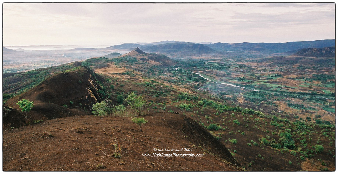
Scenes from Torna and Rajgad forts. Torna was the first major Sahyadri fort that we took an expedition to (left and right images). We returned a year later to explore the neighboring Rajgad (center image).
My personal interest in the Western Ghats was nurtured in the southern-most ranges and it took me several years to finally spend time in the hills and mountains that gave the Western Ghats their name. It is in the Sahyadris that dramatic traps, (i.e. ghats or steps) fall from the Deccan Plateau to the lower Konkan plains that border the Arabian Sea. This is an area with a fascinating geological history associated with the period of volcanism that created the Deccan Plateau and may be associated with the extinction of the dinosaurs (see links below).
During the three years that my wife and I were working at the Mahindra United World College of India I had a chance to get to know parts of the Sahyadris intimately. In 2002 when we started work the college was still relatively new and there was limited knowledge on campus about the hiking/outdoors opportunities in the area. Over my three years there I recruited a diverse collection of students, teachers and friends and set out to learn as much as possible about the landscape, ecology and culture of the Sahyadris. We used Harish Kapadia’s Trek the Sahyadris as a bible and followed it to as many of the nearby locations as we could.

Three different MUWCI hikes starting in Torna (top) in 2002 and continuing to Rajgad (2003) and Nane Ghat (2004). There are several distinguished faculty members seen here including Harendra Shukla, Karl Mossfeldt, Sandy Hartwiger, Anne Hardy, Andrew Mahlstedt and Beatrice Perez Santos. Students include Nicolas, Foong, Andree, Sadia, Tanya and several other wonderful hiking companions.
We first focused on the great and lesser-known Maratha forts(Tikona, Lohgad, Torna, Rajgad, Rajmachi, Harishchandragad, Ratangad etc.). Notable peaks near the campus were climbed, explored and camped on. Towards the end of my stay we started to explore the numerous Buddhist rock cut caves that the area is blessed with. I was a keen bird watcher but it was the Sahyadris where I was inspired to study and photograph the snakes and amphibians that we encountered (mostly on our campus, an din our home during the monsoon). Interactions with notable Pune naturalists like Ashok Captain, Vivek Gaur Broome, Ashish Kothari, Sunita Rao, Pankaj Sekhsaria, Reiner Hoerig, Erach Bharucha and others helped further my interest in the area. Through a fortuitous meeting with the state minister of education I was able to get a full set of Survey of India 1:50,000 and 1:25,000 maps of our Sahyadris area stretching from Nashik down to Mahabaleshwar for the college. As I had in the other areas of the Western Ghats, I worked to document the landscapes with medium format cameras, shooting mainly in black & white (see the High Range Photography album “Sahyadris“). I also shot color slide film (not scanned yet) and color print film on a small Olympus stylus. It’s these snapshots, originally scanned in Pune, that accompany this article.
Looking east over the Paud Valley showing the distinctive conical hill above the MUWCI campus taken from a high point that was known to students as Mt. Wilkinson (after the first MUWCI Head of School). This was taken in May after one of the first pre-monsoon showers. From February-May the hills experience fires set by grazers and farmers in the valleys. The landscape makes an amazing recovery in the monsoon months but the fire encourages deflected succession such that forests have a hard time recovering on open slopes.
The landscape of the Sahyadris is something special to behold and it changes dramatically between the dry, scorched months of the Indian summer (March-June) to the lush, verdant months of the monsoon (June-October). During my three years I worked hard to understand the nuances of the landscape and the monsoon’s impact on it. By my final year I was able to plan several trips that provided ideal lighting conditions to do justice to the landscapes.
The NASA/USGS Landsat program has given me a chance to rediscover the Sahyadris through their amazing archive of multi-spectral imagery that is now publicly available. The escarpment of the ghats was always impressive and something I tried to find the right light to do justice to. However, seen from air or space the Sahyadris are something else. The series of maps in this post are taken from a pass of Landsat on February 23rd 2014. A few days later I was in the area participating in a conference in Mumbai and I happened the tiles in Earth Explorer when I was looked to better reconnect with the Sahyadris after a 10-year gap. The tiles have taken a good deal of processing using ArcMap to get them into their current view. I have added place names of some of the notable places that we took MUWCI hikes to. There are quite a few other points (such as the Buddhist caves, Koyna Sanctuary etc.) that didn’t make it onto these versions of the maps. Nevertheless, they should be of interest to my former students, colleagues and other fascinated by the Sahyadris.

The culminating exploratory trek that I took with a MUWCI group was to the remote fortress at Ratangad. It overlooks a steep drop to the Konkan plains and has a spectacular view north to Kalsubai, the highest peak in the Sahyadris. We had a small group for this trip – Asia, Andree and a visiting math teacher from the UWC in Trieste. A year earlier I had been on an equally rewarding trip with colleagues Bill and his fiancée Richa. We camped at the breathtaking Konkan Kada with a group of some of the most wonderful MUWCI students, including Sadia, Tanya, Apoorv, Nicolas and several others.
REFERENCES
Kapadia, Harish. Trek the Sahyadris, 5th Edition. New Delhi: Indus Publishing Co. 2003. Print. Web Site.
Lockwood, Ian. “Sahyadris.” High Range Photography. 2005. Digital album on Web.
Lockwood, Ian. “Traversing the Sahyadris.” Sanctuary Asia. June 2005. Print (PDF).
Sheth, Hetu. “The Deccan: Beyond the Plumes Hypothesis.” Mantle Plumes. August 2006. Web.
MAPS

Sahyadris art ¼ : Showing the Malsej Ghats, Harishcandragad, Ratangad and Kalsubai sections of the Sahyadris.

Sahyadris Part 2/4: Showing Bhimashankar, Rajmachi and down to MUWCI.

Sahyadris Part ¾ : Showing the area from Lonavala and MUWCI down to Mahabaleshwar. This is the area that most MUWCI teachers and students became familiar with. Click on image for an A3 150 DPI version.

Sahyadris Part 4/4: Showing the area from Mahabaleshwar south to Koyna reservoir and lake. Mahabaleshwar is as far as we got during our time at MUWCI. Koyna is an important habitat for a range of wildlife including tigers, but it is under pressure from various development schemes and encroachment. Click on image for an A3 150 DPI version.
