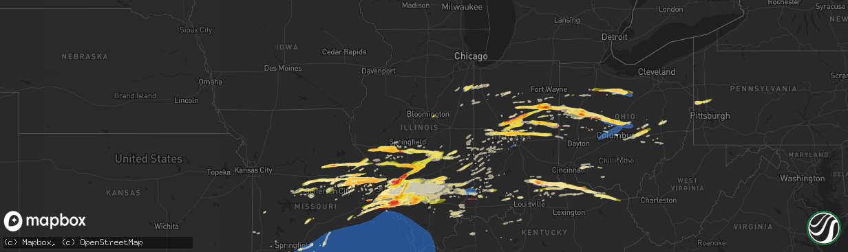
Hail Map in Illinois on March 14, 2024
The weather event in Illinois on March 14, 2024 includes Hail, Wind, and Tornado maps. 15 states and 1,835 cities were impacted and suffered possible damage. The total estimated number of properties impacted is 159,268.
Hail
Wind
Tornado
159,268
Estimated number of impacted properties by a 1.00" hail or larger81,507
Estimated number of impacted properties by a 1.75" hail or larger7,102
Estimated number of impacted properties by a 2.50" hail or largerStorm reports in Illinois
Illinois
| Date | Description |
|---|---|
| 03/14/20246:55 PM CDT | Report from mping: quarter |
| 03/14/20246:50 PM CDT | A local report indicates 60 MPH wind near Freeburg |
| 03/14/20246:48 PM CDT | Measured wind gust at freeburg eoc. |
| 03/14/20246:42 PM CDT | A local report indicates 1.75 inch wind near 2 S Smithton |
| 03/14/20246:39 PM CDT | A local report indicates 1.00 inch wind near 2 W Smithton |
| 03/14/20246:37 PM CDT | Report from mping: quarter |
| 03/14/20246:36 PM CDT | A local report indicates 1.00 inch wind near Damiansville |
| 03/14/20246:33 PM CDT | Delayed report. |
| 03/14/20246:29 PM CDT | A local report indicates 1.00 inch wind near 4 SE Mascoutah |
| 03/14/20246:26 PM CDT | Delayed report... Quarter sized hail at the corner of e harnett st and n jefferson st. |
| 03/14/20246:26 PM CDT | A local report indicates 1.25 inch wind near Posen |
| 03/14/20246:16 PM CDT | Report from mping: quarter |
| 03/14/20246:14 PM CDT | Delayed report. Time estimated from radar. |
| 03/14/20246:13 PM CDT | A local report indicates 2.50 inch wind near 3 S Nashville |
| 03/14/20246:04 PM CDT | Report from mping: quarter |
| 03/14/20246:00 PM CDT | Partial roof loss of the nashville high school gym. Time estimated by radar. |
| 03/14/20245:59 PM CDT | Report from mping: half dollar |
| 03/14/20245:59 PM CDT | Report from mping: half dollar |
| 03/14/20245:55 PM CDT | Delayed report from wcia broadcast meteorologist of half dollar hail in oconee. |
| 03/14/20245:55 PM CDT | Relayed via broadcast media. Photos of a small outbuilding/shed flipped over and a pine tree broken at the trunk. Time estimated from radar. |
| 03/14/20245:53 PM CDT | Delayed report. |
| 03/14/20245:52 PM CDT | Delayed report. |
| 03/14/20245:50 PM CDT | A local report indicates 2.00 inch wind near Litchfield |
| 03/14/20245:49 PM CDT | Report from mping: half dollar |
| 03/14/20245:40 PM CDT | Report from mping: golf ball |
| 03/14/20245:36 PM CDT | A local report indicates 1.75 inch wind near Coffeen |
| 03/14/20245:32 PM CDT | Relayed via social media post. |
| 03/14/20245:24 PM CDT | Measured half dollar hail east side of taylorville from a trained spotter. |
| 03/14/20245:22 PM CDT | Report from mping: hen egg |
| 03/14/20245:21 PM CDT | A local report indicates 2.75 inch wind near Livingston |
| 03/14/20245:20 PM CDT | Report from mping: half dollar |
| 03/14/20245:19 PM CDT | Report from mping: golf ball |
| 03/14/20245:17 PM CDT | Report from mping: quarter |
| 03/14/20245:17 PM CDT | Report from mping: golf ball |
| 03/14/20245:17 PM CDT | Report from mping: hen egg |
| 03/14/20245:17 PM CDT | A local report indicates 2.00 inch wind near 2 W Edwardsville |
| 03/14/20245:15 PM CDT | Social media photo of a large tree branch down. Time estimated from radar. |
| 03/14/20245:14 PM CDT | A local report indicates 3.00 inch wind near 1 E Livingston |
| 03/14/20245:14 PM CDT | Corrects previous hail report from 1 e livingston. |
| 03/14/20245:11 PM CDT | Report from mping: quarter |
| 03/14/20245:11 PM CDT | Delayed report. |
| 03/14/20245:11 PM CDT | Photo on twitter shows a seemingly healthy large pine tree split. Report also mentioned downed power lines. Time estimated from radar. |
| 03/14/20245:07 PM CDT | Photo from twitter shows a spikey oblong hail stone of approximately 3 inches in diameter. Time estimated from radar. |
| 03/14/20245:07 PM CDT | Corrects previous hail report from 1 e worden. Photos from twitter shows several measured hail stones up to at least 3 inches in diameter and possibly slightly larger. |
| 03/14/20245:06 PM CDT | A local report indicates 1.75 inch wind near 2 SSW Maeystown |
| 03/14/20245:04 PM CDT | Report from mping: quarter |
| 03/14/20245:04 PM CDT | Photo of quarter size hail sent via social media. Time estimated from radar. |
| 03/14/20245:03 PM CDT | Report from mping: quarter |
| 03/14/20245:01 PM CDT | A local report indicates 1.00 inch wind near 4 N Edwardsville |
| 03/14/20245:00 PM CDT | Report from mping: ping pong ball |
| 03/14/20245:00 PM CDT | Report from mping: half dollar |
| 03/14/20244:59 PM CDT | Report from mping: hen egg+ |
| 03/14/20244:59 PM CDT | Report from mping: quarter |
| 03/14/20244:57 PM CDT | Report from mping: half dollar |
| 03/14/20244:56 PM CDT | A local report indicates 1.00 inch wind near Troy |
| 03/14/20244:56 PM CDT | Report from mping: ping pong ball |
| 03/14/20244:55 PM CDT | Delayed report. |
| 03/14/20244:55 PM CDT | Report from mping: ping pong ball |
| 03/14/20244:55 PM CDT | Delayed report. |
| 03/14/20244:54 PM CDT | Delayed report. |
| 03/14/20244:54 PM CDT | A local report indicates 1.00 inch wind near Hecker |
| 03/14/20244:54 PM CDT | Report from mping: golf ball |
| 03/14/20244:54 PM CDT | A local report indicates 2.00 inch wind near 1 E Edwardsville |
| 03/14/20244:54 PM CDT | Report from mping: ping pong ball |
| 03/14/20244:54 PM CDT | Delayed report... 3.25 inch hail on southern illinois university at edwardsville. |
| 03/14/20244:53 PM CDT | Delayed report. |
| 03/14/20244:53 PM CDT | Report from mping: ping pong ball |
| 03/14/20244:53 PM CDT | A local report indicates 1.50 inch wind near 2 SW Glen Carbon |
| 03/14/20244:52 PM CDT | Delayed report. |
| 03/14/20244:51 PM CDT | Delayed report. |
| 03/14/20244:51 PM CDT | Report from mping: quarter |
| 03/14/20244:51 PM CDT | A local report indicates 1.25 inch wind near 2 W Edwardsville |
| 03/14/20244:50 PM CDT | Delayed report... Baseball sized hail on crook road between waterloo and red bud. |
| 03/14/20244:50 PM CDT | Siue campus. |
| 03/14/20244:50 PM CDT | Delayed report. |
| 03/14/20244:50 PM CDT | Report from mping: quarter |
| 03/14/20244:50 PM CDT | A local report indicates 2.00 inch wind near 1 W Troy |
| 03/14/20244:50 PM CDT | Delayed report... Two inch hail at southern illinois university... Edwardsville. |
| 03/14/20244:50 PM CDT | Delayed report. |
| 03/14/20244:49 PM CDT | Delayed report. |
| 03/14/20244:49 PM CDT | Report from mping: quarter |
| 03/14/20244:48 PM CDT | A local report indicates 1.75 inch wind near 1 E Maryville |
| 03/14/20244:48 PM CDT | A local report indicates 2.75 inch wind near 2 ESE New Design |
| 03/14/20244:47 PM CDT | A local report indicates 1.75 inch wind near Glen Carbon |
| 03/14/20244:47 PM CDT | Delayed report. |
| 03/14/20244:47 PM CDT | Delayed report. |
| 03/14/20244:47 PM CDT | Report from mping: quarter |
| 03/14/20244:47 PM CDT | Report from mping: quarter |
| 03/14/20244:46 PM CDT | Delayed report. |
| 03/14/20244:45 PM CDT | A local report indicates 1.25 inch wind near Glen Carbon |
| 03/14/20244:45 PM CDT | Delayed report. |
| 03/14/20244:45 PM CDT | Delayed report. |
| 03/14/20244:44 PM CDT | Report from mping: ping pong ball |
| 03/14/20244:43 PM CDT | Report from mping: quarter |
| 03/14/20244:42 PM CDT | Delayed report. |
| 03/14/20244:39 PM CDT | A local report indicates 1.25 inch wind near 1 NE Granite City |
| 03/14/20244:37 PM CDT | A local report indicates 1.00 inch wind near Franklin |
| 03/14/20244:36 PM CDT | Report from mping: quarter |
| 03/14/20244:29 PM CDT | A local report indicates 1.75 inch wind near Mascoutah |
| 03/14/20244:23 PM CDT | Broadcast media posted a picture of very large hailstones ranging from 3 to 4 inches. |
| 03/14/20244:21 PM CDT | Morgan co reported golfball sized hail in murrayville. |
| 03/14/20244:17 PM CDT | Delayed report. |
| 03/14/20244:14 PM CDT | Halfway between collinsville and granite city. |
| 03/14/20244:04 PM CDT | Scott co ema called to report golf ball sized hail in winchester. |
| 03/14/20248:29 AM CDT | Delayed report. Relayed from broadcast media. Time estimated from radar. |
| 03/14/20248:16 AM CDT | Multiple semi-trucks were blown over along i-55 northbound between litchfield and farmersville. Time and exact location estimated from nws lincoln radar. |
| 03/14/20247:58 AM CDT | An ef-0 tornado with maximum winds of 80 mph and a maximum width of 100 yards was surveyed. The tornado touched down 5 miles southwest of carlinville... Il along shipma |
| 03/14/20247:46 AM CDT | A brief ef-0 tornado touched down north of brighton... Il in jersey county... Il. The tornado crossed the jersey/macoupin county line... Lifting two minutes later. Maxi |
| 03/14/20247:45 AM CDT | Illinois state highway patrol reported multiple road blockages due to downed power lines just south of medora along illinois highway 267 and illinois highway 111. Time |
| 03/14/20247:44 AM CDT | An ef-0 tornado with maximum winds of 85 mph and a width of 75 yards was surveyed south of fidelity... Il. The tornado touched down southwest of fidelity in jersey coun |
| 03/14/20247:31 AM CDT | Roof of machine shed blown off and damage to rafters underneath. |
| 03/14/20247:28 AM CDT | Corrects date of previous tornado report from 3 ese fieldon. A weak tornado was surveyed in central jersey county... Il south of jersey. Damage to trees... Siding... An |
| 03/14/20247:28 AM CDT | Corrects date of previous tornado report from 3 ese fieldon. A weak ef-0 tornado was surveyed in central jersey county... Il south of jersey. Damage to trees... Siding. |
| 03/14/20247:25 AM CDT | Extensive tree damage. Large branches snapped off trees... Large trees uprooted and snapped vertically along trunk. |
| 03/14/20247:20 AM CDT | Numerous 18 to 24 inch diameter pine trees stripped of branches and snapped near their tops. Large tree branch snapped near base. |
| 03/13/20249:29 PM CDT | Trained spotter shared a picture on twitter of a brick building with a part of an exterior wall collapsed on the town square in west salem. Time estimated by radar. |
| 03/13/20248:55 PM CDT | A local report indicates 61 MPH wind near Mount Carmel Airport |
| 03/13/20248:36 PM CDT | Tops removed off of cedar trees near e 700 road and wabash 17. |
| 03/13/20248:35 PM CDT | Roof off the south side of a church at 400 east and wabash 17. |
| 03/13/20248:29 PM CDT | Corrects previous tstm wnd dmg report from west salem. Trained spotter shared a picture on twitter of a brick building with a part of an exterior wall collapsed on the |
| 03/13/20248:11 PM CDT | Ef-1 tornado with estimated peak winds 90 mph. Path length 2.8 miles. Path width 75 yards. Tornado touched down 4.7 miles northeast of fairfield il at 8:11 pm cdt and l |
| 03/13/20248:07 PM CDT | Reports of thousands of power outages. |
| 03/13/20248:07 PM CDT | Repor |
| 03/13/20248:07 PM CDT | Fairly widespread tree and powerline damage. Investigating one building with the roof removed in wayne co. |
| 03/13/20248:00 PM CDT | Multiple trees down on county road 2400 n just west of county road 800 e. Top of grain bin blown off into roadway. |
| 03/13/20248:00 PM CDT | Part of a roof blown off a machine shed in northern hamilton county along state highway 242. |
| 03/13/20247:51 PM CDT | Report from mping: quarter |
| 03/13/20247:50 PM CDT | Trees down. |
| 03/13/20247:47 PM CDT | Delayed report. |
| 03/13/20247:46 PM CDT | Power outages reported. |
| 03/13/20247:39 PM CDT | A local report indicates 60 MPH wind near 1 SW Mount Vernon |
| 03/13/20247:37 PM CDT | A local report indicates 1.00 inch wind near 1 SW Mount Vernon |
| 03/13/20247:35 PM CDT | Roof and structure damage to the south central transit bus building and office on highway 37 just north of mount vernon. Time estimated from radar. |
| 03/13/20247:33 PM CDT | Cell merger appears to have led to brief tornado along il highway 37. Two metal buildings had much of their roof removed... Bay doors blown out... And large portions of |
| 03/13/20247:30 PM CDT | Report from mping: quarter |
| 03/13/20247:27 PM CDT | Report from mping: quarter |
| 03/13/20247:10 PM CDT | Report from mping: quarter |
All States Impacted by Hail Map on March 14, 2024
Cities Impacted by Hail Map on March 14, 2024
- Saint Augustine, IL
- Abingdon, IL
- Avon, IL
- Prairie City, IL
- Berwick, IL
- Eureka, KS
- Hamilton, KS
- Virgil, KS
- Gridley, KS
- Madison, KS
- Toronto, KS
- Yates Center, KS
- Burlington, KS
- Le Roy, KS
- Westphalia, KS
- Garnett, KS
- Waverly, KS
- Piqua, KS
- Downs, IL
- Le Roy, IL
- Ellsworth, IL
- Mora, MO
- Smithton, MO
- Florence, MO
- Otterville, MO
- Syracuse, MO
- Fortuna, MO
- Tipton, MO
- Clarksburg, MO
- Saint Anne, IL
- Momence, IL
- Kankakee, IL
- California, MO
- Latham, MO
- Pembroke Township, IL
- Lake Village, IN
- Schneider, IN
- Lowell, IN
- Tower Hill, IL
- Shelbyville, IL
- Lakewood, IL
- Martinsville, IL
- Annapolis, IL
- West York, IL
- West Union, IL
- Jefferson City, MO
- Holts Summit, MO
- Tebbetts, MO
- Indianapolis, IN
- Camby, IN
- Comanche, OK
- Duncan, OK
- Waurika, OK
- Macomb, OK
- Asher, OK
- Maud, OK
- Tecumseh, OK
- Marlow, OK
- Foster, OK
- Henrietta, TX
- Elmore City, OK
- Lindsay, OK
- Maysville, OK
- Pauls Valley, OK
- Ringling, OK
- Loco, OK
- Shawnee, OK
- Prague, OK
- Wetumka, OK
- Weleetka, OK
- Okemah, OK
- Henryetta, OK
- Okmulgee, OK
- Ringgold, TX
- Paris Crossing, IN
- Commiskey, IN
- Deputy, IN
- Madison, IN
- Lexington, IN
- Morris, OK
- Chouteau, OK
- Chamois, MO
- Twelve Mile, IN
- Arthur, IL
- Oblong, IL
- Star City, IN
- Kewanna, IN
- Crothersville, IN
- Brookston, IN
- Jasonville, IN
- Sullivan, IN
- Demotte, IN
- Farmersburg, IN
- Lewis, IN
- Shelburn, IN
- Terre Haute, IN
- Pimento, IN
- Odon, IN
- Newberry, IN
- Elnora, IN
- West Terre Haute, IN
- Sheldon, IL
- Kentland, IN
- Sedalia, MO
- Green Ridge, MO
- Ryan, OK
- Brazil, IN
- Earlsboro, OK
- Seminole, OK
- Cole Camp, MO
- Rosedale, IN
- Wanette, OK
- Herscher, IL
- Bonfield, IL
- Akron, IN
- Macy, IN
- Willow Hill, IL
- Yale, IL
- Clinton, IN
- Riley, IN
- New Goshen, IN
- Wewoka, OK
- Georgetown, IL
- Ridge Farm, IL
- Indianola, IL
- Castle, OK
- Wheatfield, IN
- Rensselaer, IN
- Fair Oaks, IN
- Paris, IL
- Wolcott, IN
- Mooresville, IN
- Monrovia, IN
- Chrisman, IL
- Holdenville, OK
- Freelandville, IN
- Sandborn, IN
- Oaktown, IN
- Bicknell, IN
- Edwardsport, IN
- Sullivan, IL
- Lovington, IL
- Paoli, OK
- Wayne, OK
- Byars, OK
- Francesville, IN
- Winamac, IN
- Byers, TX
- Vincennes, IN
- Plainville, IN
- Earl Park, IN
- Goodland, IN
- Ada, OK
- Aroma Park, IL
- Cook Sta, MO
- Onarga, IL
- Bainbridge, IN
- Roachdale, IN
- Lexington, OK
- Montezuma, IN
- Hillsdale, IN
- Pryor, OK
- Hanover, IN
- Milton, KY
- Nocona, TX
- Terral, OK
- Wynnewood, OK
- Stratford, OK
- Locust Grove, OK
- Boynton, OK
- Salina, OK
- Haskell, OK
- Vevay, IN
- Spavinaw, OK
- Porter, OK
- Taft, OK
- Gore, OK
- Jay, OK
- Vian, OK
- Grove, OK
- Park Hill, OK
- Cookson, OK
- Davis, OK
- Muskogee, OK
- South West City, MO
- Eucha, OK
- Colcord, OK
- Ghent, KY
- Florence, IN
- Warsaw, KY
- Sparta, KY
- Sanders, KY
- Glencoe, KY
- Dry Ridge, KY
- Carrollton, KY
- Sulphur, OK
- Anderson, MO
- Verona, KY
- Roff, OK
- Crittenden, KY
- Williamstown, KY
- Tahlequah, OK
- De Mossville, KY
- Falmouth, KY
- Wagoner, OK
- Gravette, AR
- Maysville, AR
- Sulphur Springs, AR
- Patriot, IN
- Butler, KY
- Foster, KY
- Eufaula, OK
- Checotah, OK
- Noel, MO
- Brooksville, KY
- Oktaha, OK
- Bella Vista, AR
- Hiwasse, AR
- Pineville, MO
- West Jefferson, OH
- London, OH
- Plain City, OH
- Hilliard, OH
- Dublin, OH
- Amlin, OH
- Galloway, OH
- Columbus, OH
- Lewis Center, OH
- Westerville, OH
- Galena, OH
- Powell, OH
- New Albany, OH
- Fort Gibson, OK
- Hulbert, OK
- Augusta, KY
- Germantown, KY
- Welling, OK
- Proctor, OK
- Mayslick, KY
- Mount Olivet, KY
- Maysville, KY
- Dover, KY
- Braggs, OK
- Bunch, OK
- Westville, OK
- Stilwell, OK
- Kansas, OK
- Watts, OK
- Stigler, OK
- Mokane, MO
- Steedman, MO
- Centralia, MO
- Sturgeon, MO
- Decatur, AR
- Gentry, AR
- Summers, AR
- Siloam Springs, AR
- Harrisburg, MO
- Fayetteville, AR
- Canehill, AR
- Lincoln, AR
- Evansville, AR
- Thompson, MO
- Mexico, MO
- Portland, MO
- Rhineland, MO
- Hermann, MO
- Springdale, AR
- Bentonville, AR
- Winslow, AR
- Prairie Grove, AR
- Farmington, AR
- West Fork, AR
- Morrow, AR
- Tollesboro, KY
- Rogers, AR
- Cave Springs, AR
- Lowell, AR
- Pea Ridge, AR
- Centerton, AR
- Bunceton, MO
- Pilot Grove, MO
- Berryville, AR
- Prairie Home, MO
- Boonville, MO
- Green Forest, AR
- Warrenton, MO
- Marthasville, MO
- Jonesburg, MO
- Goodman, MO
- Sullivan, MO
- Lonedell, MO
- Richwoods, MO
- Bourbon, MO
- Luebbering, MO
- Grubville, MO
- Dittmer, MO
- Elkins, AR
- Garfield, AR
- Laddonia, MO
- Rush Hill, MO
- Farber, MO
- Curryville, MO
- Vandalia, MO
- Porum, OK
- Middletown, MO
- Bowling Green, MO
- Mill Creek, OK
- Tishomingo, OK
- Pittsfield, IL
- Pearl, IL
- Winchester, IL
- Wallingford, KY
- Vanceburg, KY
- Hillsboro, MO
- Stonewall, OK
- Truesdale, MO
- Wright City, MO
- Foristell, MO
- Wentzville, MO
- Clever, MO
- Nixa, MO
- Ozark, MO
- Sparta, MO
- Montgomery City, MO
- Rogersville, MO
- New Florence, MO
- Fordland, MO
- Bruner, MO
- Wooldridge, MO
- Jamestown, MO
- Columbia, MO
- Oldfield, MO
- Seymour, MO
- Ava, MO
- Squires, MO
- Mansfield, MO
- Ashland, MO
- Clarksville, MO
- Sallisaw, OK
- Nebo, IL
- Eolia, MO
- Lake Saint Louis, MO
- O'Fallon, MO
- Pevely, MO
- Barnhart, MO
- Festus, MO
- Herculaneum, MO
- Webbers Falls, OK
- Waterloo, IL
- Smithton, IL
- New Athens, IL
- Tupelo, OK
- Golden Eagle, IL
- Saint Charles, MO
- Saint Peters, MO
- Drury, MO
- Norwood, MO
- Macomb, MO
- Mountain Grove, MO
- Marshfield, MO
- Hartville, MO
- Oak Grove, AR
- Lead Hill, AR
- Alpena, AR
- Omaha, AR
- Wesley, AR
- Eureka Springs, AR
- Hindsville, AR
- Huntsville, AR
- Lampe, MO
- Cedarcreek, MO
- Eagle Rock, MO
- Golden, MO
- Branson, MO
- Shell Knob, MO
- Hollister, MO
- Ridgedale, MO
- Blue Eye, MO
- Kirbyville, MO
- Marble Falls, AR
- Compton, AR
- Kingston, AR
- Ponca, AR
- Combs, AR
- Witter, AR
- Jasper, AR
- Harrison, AR
- Reeds Spring, MO
- Olive Hill, KY
- Emerson, KY
- Rockaway Beach, MO
- Grayson, KY
- Fulton, MO
- High Hill, MO
- Bellflower, MO
- Truxton, MO
- Hawk Point, MO
- Troy, MO
- Elsberry, MO
- Annada, MO
- Jacksonville, IL
- Murrayville, IL
- Woodson, IL
- Franklin, IL
- Waverly, IL
- Virden, IL
- Granite City, IL
- Konawa, OK
- Edwardsville, IL
- Williamsburg, MO
- Collinsville, IL
- Glen Carbon, IL
- Maryville, IL
- Troy, IL
- Valmeyer, IL
- Fults, IL
- Lynchburg, MO
- Grovespring, MO
- Graff, MO
- Plato, MO
- Huggins, MO
- Cabool, MO
- Houston, MO
- Vanzant, MO
- Solo, MO
- Bucyrus, MO
- Willow Springs, MO
- Elk Creek, MO
- Dora, MO
- Yellville, AR
- Theodosia, MO
- Rueter, MO
- Isabella, MO
- Protem, MO
- Kissee Mills, MO
- Peel, AR
- Oakland, AR
- Everton, AR
- Western Grove, AR
- Pyatt, AR
- Marine, IL
- Keota, OK
- La Fontaine, IN
- Bunker Hill, IN
- Marion, IN
- Miami, IN
- Highland, IL
- Amboy, IN
- Van Buren, IN
- Aviston, IL
- Warren, IN
- Montpelier, IN
- Trenton, IL
- Converse, IN
- Peru, IN
- Gans, OK
- Muldrow, OK
- Portage Des Sioux, MO
- Red Bud, IL
- Florissant, MO
- Hecker, IL
- Freeburg, IL
- Kinta, OK
- Auburn, IL
- Divernon, IL
- Pawnee, IL
- Thayer, IL
- Mascoutah, IL
- Belleville, IL
- Lenzburg, IL
- Mccurtain, OK
- Poneto, IN
- Liberty Center, IN
- Bluffton, IN
- Lebanon, IL
- Morrisonville, IL
- Potosi, MO
- Carrollton, IL
- Summerfield, IL
- Kane, IL
- Eldred, IL
- Centrahoma, OK
- Rockbridge, IL
- Saint James, MO
- Steelville, MO
- Coalgate, OK
- Greenfield, IL
- Frankfort, IN
- Colfax, IN
- Chesterfield, IL
- Medora, IL
- Saint Louis, MO
- Michigantown, IN
- Arnold, MO
- Imperial, MO
- East Alton, IL
- Wardville, OK
- South Roxana, IL
- Hartford, IL
- Stuart, OK
- Pocahontas, IL
- Fenton, MO
- Mcalester, OK
- Worden, IL
- Alhambra, IL
- Hamel, IL
- New Douglas, IL
- Livingston, IL
- East Carondelet, IL
- Blackwell, MO
- De Soto, MO
- Fletcher, MO
- Keystone, IN
- Geneva, IN
- Marietta, OK
- Roxana, IL
- Kiowa, OK
- Berne, IN
- Beulah, MO
- Edgar Springs, MO
- Lenox, MO
- Roby, MO
- Salem, MO
- Success, MO
- Licking, MO
- Raymondville, MO
- Jadwin, MO
- Eminence, MO
- Summersville, MO
- Yukon, MO
- Eunice, MO
- Hartshorn, MO
- Birch Tree, MO
- Mountain View, MO
- Caulfield, MO
- Peace Valley, MO
- Pomona, MO
- West Plains, MO
- Moody, MO
- Pottersville, MO
- Bakersfield, MO
- Elizabeth, AR
- Tecumseh, MO
- Gamaliel, AR
- Gepp, AR
- Henderson, AR
- Zanoni, MO
- Brixey, MO
- Bull Shoals, AR
- Gainesville, MO
- Gassville, AR
- Cotter, AR
- Flippin, AR
- Norfork, AR
- Summit, AR
- Lakeview, AR
- Valley Springs, AR
- Pontiac, MO
- Mountain Home, AR
- Saint Joe, AR
- Midway, AR
- Udall, MO
- Clarkridge, AR
- Calico Rock, AR
- Wasola, MO
- Hardenville, MO
- Thornfield, MO
- Prairie Du Rocher, IL
- Kempton, IN
- Forest, IN
- Russiaville, IN
- Tipton, IN
- Sharpsville, IN
- Taylorville, IL
- Bulpitt, IL
- Kincaid, IL
- Edinburg, IL
- Tovey, IL
- Goldsmith, IN
- Assumption, IL
- Stonington, IL
- Hettick, IL
- Carlinville, IL
- Rudy, AR
- Mountainburg, AR
- Columbia, IL
- Chester, AR
- Fort Smith, AR
- Barling, AR
- Lavaca, AR
- Alma, AR
- Van Buren, AR
- Dupo, IL
- Petroleum, IN
- Gillespie, IL
- Gainesville, TX
- Bokoshe, OK
- Spiro, OK
- Marissa, IL
- Addieville, IL
- Saint Libory, IL
- Litchfield, IL
- Shipman, IL
- O'Fallon, IL
- Haslet, TX
- Madill, OK
- Fort Worth, TX
- Rockford, OH
- Celina, OH
- Mendon, OH
- Hartford City, IN
- Cameron, OK
- Wabash, IN
- Inola, OK
- Wellsville, MO
- Fieldon, IL
- Kokomo, IN
- Ossian, IN
- Decatur, IN
- South Greenfield, MO
- Galveston, IN
- Walton, IN
- Markle, IN
- Walnut Shade, MO
- Dustin, OK
- Peebles, OH
- Brussels, IL
- Afton, OK
- Vinita, OK
- Thorntown, IN
- Darlington, IN
- Bradleyville, MO
- Healdton, OK
- Graham, OK
- Ratliff City, OK
- Springer, OK
- Scottsburg, IN
- Austin, IN
- Flemingsburg, KY
- Dupont, IN
- New Berlin, IL
- Scott Air Force Base, IL
- East Saint Louis, IL
- Greentown, IN
- Poteau, OK
- Huntington, IN
- Ladoga, IN
- Chelsea, OK
- Talala, OK
- Oologah, OK
- Sasakwa, OK
- Adair, OK
- Lebanon, IN
- Kirklin, IN
- Rose, OK
- Crystal City, MO
- Schell City, MO
- Monett, MO
- Purdy, MO
- Pierce City, MO
- Canadian, OK
- Hanna, OK
- Bryant, IN
- Pennville, IN
- Eldridge, MO
- Lebanon, MO
- Stoutland, MO
- Depew, OK
- Bristow, OK
- Ozark, AR
- Lamar, MO
- Auxvasse, MO
- Kingdom City, MO
- Broken Arrow, OK
- Strang, OK
- McCune, KS
- Cedarville, AR
- Aurora, MO
- Saint Jacob, IL
- Smithville, OK
- Heavener, OK
- Boles, AR
- Mena, AR
- West Alton, MO
- Powell, MO
- Washburn, MO
- Rocky Comfort, MO
- Forsyth, MO
- Taneyville, MO
- Venice, IL
- Caseyville, IL
- Lovejoy, IL
- Madison, IL
- Crawfordsville, IN
- New Bloomfield, MO
- Council Hill, OK
- Fitzhugh, OK
- Tunas, MO
- Buffalo, MO
- Milburn, OK
- White Hall, IL
- Kampsville, IL
- Liberal, MO
- Mindenmines, MO
- Windfall, IN
- Lanagan, MO
- Stella, MO
- Montreal, MO
- Mount Judea, AR
- Vendor, AR
- Galena, MO
- Kimberling City, MO
- Lagro, IN
- Bethany, IL
- Paden, OK
- Milton, IL
- Wood River, IL
- Rockville, MO
- Garrison, MO
- Chadwick, MO
- New Baden, IL
- Germantown, IL
- Bartelso, IL
- Carlyle, IL
- Albers, IL
- Camdenton, MO
- Billings, MO
- Natural Dam, AR
- Broken Bow, OK
- Ionia, MO
- Warner, OK
- Walnut, KS
- Saint Paul, KS
- Girard, KS
- Seligman, MO
- Fairview, MO
- Neosho, MO
- Stark City, MO
- Highlandville, MO
- La Russell, MO
- Chatham, IL
- Roanoke, TX
- Beggs, OK
- Indianola, OK
- Bowlegs, OK
- Uniontown, AR
- Whitefield, OK
- Swayzee, IN
- Jonesboro, IN
- Fairmount, IN
- Savanna, OK
- Butler, IL
- Moweaqua, IL
- Hillsboro, IL
- Argyle, TX
- Irving, IL
- Witt, IL
- Keller, TX
- Fort Jennings, OH
- Ottoville, OH
- Flower Mound, TX
- Krebs, OK
- Charleston, AR
- Findlay, IL
- Calvin, OK
- Saint Marys, OH
- Gas City, IN
- Mulberry, AR
- Windsor, IL
- Gays, IL
- Jamestown, IN
- Allen, OK
- Mattoon, IL
- Charleston, IL
- Sheridan, IN
- Atlanta, IN
- Nokomis, IL
- Fillmore, IL
- Arcadia, IN
- Denton, TX
- Waldron, AR
- Parks, AR
- Lewisville, TX
- Harvey, AR
- Hartshorne, OK
- Strasburg, IL
- Lamar, OK
- Ashmore, IL
- Findlay, OH
- Atwood, OK
- Coleman, OK
- Wapanucka, OK
- Caddo Gap, AR
- Norman, AR
- Lake Dallas, TX
- Little Elm, TX
- Aubrey, TX
- Fostoria, OH
- Arcadia, OH
- Alvada, OH
- Wapakoneta, OH
- New Riegel, OH
- Carey, OH
- Tiffin, OH
- Uniopolis, OH
- Whitestown, IN
- Zionsville, IN
- Dover, AR
- Pelsor, AR
- Carmel, IN
- Westfield, IN
- Noblesville, IN
- Gravelly, AR
- Bluffton, AR
- Bloomville, OH
- Republic, OH
- Attica, OH
- Summitville, IN
- Alexandria, IN
- Gaston, IN
- Muncie, IN
- Yorktown, IN
- Albany, IN
- Eaton, IN
- Wilburton, OK
- Watson, OK
- Fishers, IN
- Red Oak, OK
- Quinton, OK
- Cove, AR
- Hatfield, AR
- Lakeview, OH
- Frisco, TX
- Sycamore, OH
- New Bremen, OH
- New Knoxville, OH
- Botkins, OH
- Jackson Center, OH
- Lewistown, OH
- Belle Center, OH
- Huntsville, OH
- Prosper, TX
- Celina, TX
- Hamilton, MS
- Farmland, IN
- Parker City, IN
- Winchester, IN
- Ridgeville, IN
- Aberdeen, MS
- Pendleton, IN
- Greenwood Springs, MS
- Amory, MS
- Advance, IN
- New Washington, OH
- Atoka, OK
- Smithville, MS
- Willard, OH
- Hamilton, AL
- Tremont, MS
- Fulton, MS
- Briggsville, AR
- Danville, AR
- Russells Point, OH
- Bingham, IL
- Bonnerdale, AR
- Mount Ida, AR
- Plymouth, OH
- Shelby, OH
- Tiro, OH
- Markleville, IN
- Crowder, OK
- Millstadt, IL
- Coulterville, IL
- Oakdale, IL
- Mckinney, TX
- Nashville, IL
- Ashley, IL
- Plainview, AR
- Vina, AL
- Golden, MS
- Red Bay, AL
- Anna, TX
- New Castle, IN
- Shirley, IN
- Middletown, IN
- Kenefic, OK
- Shiloh, OH
- Greenwich, OH
- Leadwood, MO
- Irondale, MO
- Mineral Point, MO
- Davisville, MO
- Bonne Terre, MO
- Valles Mines, MO
- Cherryville, MO
- Belgrade, MO
- Bismarck, MO
- Park Hills, MO
- Cadet, MO
- Boss, MO
- Belleview, MO
- Bixby, MO
- Centerville, MO
- Viburnum, MO
- Ellington, MO
- Caledonia, MO
- French Village, MO
- Black, MO
- Bunker, MO
- Piedmont, MO
- Koshkonong, MO
- Redford, MO
- Fremont, MO
- Annapolis, MO
- Middle Brook, MO
- Van Buren, MO
- Pilot Knob, MO
- Lesterville, MO
- Alton, MO
- Arcadia, MO
- Vulcan, MO
- Ironton, MO
- Farmington, MO
- Winona, MO
- Doe Run, MO
- Bexar, AR
- Couch, MO
- Thayer, MO
- Viola, AR
- Camp, AR
- Mammoth Spring, AR
- Sturkie, AR
- Brandsville, MO
- Dolph, AR
- Salem, AR
- Raymond, OH
- West Mansfield, OH
- Marysville, OH
- Broadway, OH
- Ridgeway, OH
- Rushsylvania, OH
- Bellefontaine, OH
- Zanesfield, OH
- East Liberty, OH
- Oakland, IL
- Richwood, OH
- Oden, AR
- Trilla, IL
- Lerna, IL
- Van Alstyne, TX
- Staunton, IL
- Sorento, IL
- Jessieville, AR
- Mountain Pine, AR
- Hot Springs Village, AR
- Walshville, IL
- Panama, IL
- Donnellson, IL
- Hagerstown, IN
- Mooreland, IN
- Losantville, IN
- Coffeen, IL
- Union City, IN
- Saratoga, IN
- Ostrander, OH
- Magnetic Springs, OH
- Radnor, OH
- Belmont, MS
- Raymond, IL
- Rosamond, IL
- Pana, IL
- Oconee, IL
- Ramsey, IL
- Delaware, OH
- Caddo, OK
- Caney, OK
- Economy, IN
- Williamsburg, IN
- Modoc, IN
- Pencil Bluff, AR
- Greenville, IL
- Mulberry Grove, IL
- Smithboro, IL
- Vandalia, IL
- Richview, IL
- Hoyleton, IL
- Pocola, OK
- Woodlawn, IL
- Mount Vernon, IL
- Opdyke, IL
- Bluford, IL
- Belle Rive, IL
- Keenes, IL
- Wayne City, IL
- Sims, IL
- Fairfield, IL
- Beaver Falls, PA
- Rochester, PA
- Fombell, PA
- New Brighton, PA
- Zelienople, PA
- Harmony, PA
- Evans City, PA
- Renfrew, PA
- Connoquenessing, PA
- Butler, PA
- Beaver, PA
- Whitewright, TX
- Bono, AR
- Paragould, AR
- Sunbury, OH
- Tioga, TX
- Howe, TX
- Gunter, TX
- Blue Ridge, TX
- Leonard, TX
- Trenton, TX
- Stringtown, OK
- Lane, OK
- Thornville, OH
- Jacksontown, OH
- Heath, OH
- Hebron, OH
- Lonsdale, AR
- Paron, AR
- Benton, AR
- Glenford, OH
- Mount Perry, OH
- Hopewell, OH
- Nashport, OH
- Alexander, AR
- Little Rock, AR
- Croton, OH
- Centerburg, OH
- Johnstown, OH
- Utica, OH
- Newark, OH
- Alexandria, OH
- Granville, OH
- Saint Louisville, OH
- Zanesville, OH
- Frazeysburg, OH
- Dresden, OH
- Sims, AR
- Arkadelphia, AR
- Leola, AR
- Malvern, AR
- Westpoint, TN
- Iron City, TN
- Lawrenceburg, TN
- Loretto, TN
- Randolph, TX
- Bonham, TX
- Prattsville, AR
- Poyen, AR
- Patoka, IN
- Princeton, IN
- Saint Paris, OH
- Urbana, OH
- Celeste, TX
- Klondike, TX
- Cooper, TX
- Francisco, IN
- Roland, AR
- Patterson, MO
- Mill Spring, MO
- Ellsinore, MO
- Des Arc, MO
- Fredericktown, MO
- Silva, MO
- Patton, MO
- Marquand, MO
- Lodi, MO
- Sainte Genevieve, MO
- Marble Hill, MO
- Greenville, MO
- Clubb, MO
- Glenallen, MO
- Wappapello, MO
- Williamsville, MO
- Grandin, MO
- Oran, MO
- Chaffee, MO
- Brownwood, MO
- Whitewater, MO
- Bloomsdale, MO
- Zalma, MO
- Leopold, MO
- McGee, MO
- Lowndes, MO
- Sturdivant, MO
- Gipsy, MO
- Advance, MO
- Perryville, MO
- Bloomfield, MO
- Puxico, MO
- Bell City, MO
- Scott City, MO
- Bertrand, MO
- Friedheim, MO
- Jackson, MO
- Oak Ridge, MO
- Cape Girardeau, MO
- Vanduser, MO
- Sikeston, MO
- Millersville, MO
- Benton, MO
- Charleston, MO
- Daisy, MO
- Burfordville, MO
- Sedgewickville, MO
- Saint Mary, MO
- Ava, IL
- Cobden, IL
- Jacob, IL
- Chester, IL
- Cairo, IL
- McClure, IL
- Altenburg, MO
- Rockwood, IL
- Villa Ridge, IL
- Mounds, IL
- Miller City, IL
- Anna, IL
- Uniontown, MO
- Old Appleton, MO
- Ullin, IL
- Jonesboro, IL
- Wolf Lake, IL
- Pomona, IL
- Carbondale, IL
- Alto Pass, IL
- Makanda, IL
- Gorham, IL
- Frohna, MO
- Olive Branch, IL
- Pulaski, IL
- Murphysboro, IL
- Grand Tower, IL
- Tamms, IL
- Dongola, IL
- Thebes, IL
- Farrar, MO
- Campbell Hill, IL
- Steeleville, IL
- Ellis Grove, IL
- Modoc, IL
- Grantsburg, IL
- Belknap, IL
- Karnak, IL
- Kevil, KY
- Bardwell, KY
- Metropolis, IL
- Grand Chain, IL
- La Center, KY
- Buncombe, IL
- Goreville, IL
- Barlow, KY
- Paducah, KY
- Mound City, IL
- Vienna, IL
- Cypress, IL
- Melber, KY
- West Paducah, KY
- Cunningham, KY
- Wickliffe, KY
- Olmsted, IL
- Florence, AL
- Jonesboro, AR
- Brookland, AR
- Brookston, TX
- Sumner, TX
- Wolfe City, TX
- Summertown, TN
- Ethridge, TN
- Mount Pleasant, TN
- Mount Carmel, IL
- Allendale, IL
- Decker, IN
- Sumner, IL
- Saint Francisville, IL
- Hazleton, IN
- Monroe City, IN
- Petersburg, IN
- Loogootee, IN
- Cannelburg, IN
- Shoals, IN
- Bedford, KY
- Ashland City, TN
- English, IN
- Marengo, IN
- Palmyra, IN
- Pattonville, TX
- Paris, TX
- Blossom, TX
- Deport, TX
- Detroit, TX
- Pekin, IN
- Borden, IN
- Greenville, IN
- Clarksville, TX
- Russellville, AL
- Union City, OH
- Portland, IN
- Arcanum, OH
- New Madison, OH
- Chesterfield, MO
- Reelsville, IN
- Carbon, IN
- Cloverdale, IN
- Greencastle, IN
- Flora, IL
- Silex, MO
- Westfield, IL
- Casey, IL
- Story, AR
- Girard, IL
- Palmyra, IL
- Columbus Grove, OH
- Pandora, OH
- Rawson, OH
- Ottawa, OH
- Bluffton, OH
- Mount Cory, OH
- Hillsboro, IN
- Anderson, IN
- Alamo, IN
- Lapel, IN
- Fortville, IN
- New Ross, IN
- Waynetown, IN
- Vermilion, IL
- Berger, MO
- Savannah, TN
- Olivehill, TN
- Murray, KY
- Hazel, KY
- Sulligent, AL
- Nettleton, MS
- Columbus, MS
- Detroit, AL
- West Point, MS
- Selma, IN
- Frankton, IN
- Elwood, IN
- Dunkirk, IN
- Upland, IN
- Pilot Point, TX
- Clinton, AR
- Dennard, AR
- Batchtown, IL
- Cory, IN
- Bagwell, TX
- Mansfield, AR
- Piqua, OH
- Sparkman, AR
- Carthage, AR
- Fillmore, IN
- Versailles, MO
- Barnett, MO
- Russellville, MO
- Warsaw, OH
- Gurdon, AR
- McComb, OH
- Marshall, IN
- Rockville, IN
- House Springs, MO
- Bonnie, IL
- Ina, IL
- Campbell, TX
- Commerce, TX
- Cumby, TX
- Defiance, MO
- Augusta, MO
- Worthington, IN
- Switz City, IN
- Versailles, OH
- Greenville, OH
- Bradford, OH
- Norris City, IL
- Carmi, IL
- New Harmony, IN
- Enfield, IL
- Wadesville, IN
- New Haven, IL
- Mount Vernon, IN
- Hackett, AR
- Greenwood, AR
- Uniondale, IN
- Clayton, OK
- Centerpoint, IN
- Merom, IN
- Bridgeport, IL
- Flat Rock, IL
- Lawrenceville, IL
- Claremont, IL
- Olney, IL
- Okawville, IL
- Centertown, MO
- Poseyville, IN
- Evansville, IN
- Haubstadt, IN
- Batavia, OH
- Centralia, IL
- Pittsburg, OK
- Blanco, OK
- Lamar, AR
- Ardmore, OK
- Mannsville, OK
- Daisy, OK
- Hagarville, AR
- Carlisle, IN
- Palestine, IL
- Ansonia, OH
- Loami, IL
- Robertsville, MO
- Moscow Mills, MO
- Old Monroe, MO
- Hot Springs National Park, AR
- Maumelle, AR
- Griffin, IN
- Owensville, IN
- Antlers, OK
- Finley, OK
- Rattan, OK
- Collinwood, TN
- Lyons, IN
- Bloomfield, IN
- Scotland, IN
- Royal, AR
- Glenwood, AR
- Otisco, IN
- Marysville, IN
- Harrisburg, AR
- Bethel, OK
- Scranton, AR
- New Blaine, AR
- Washington, IN
- Hardinsburg, KY
- Roann, IN
- Booneville, AR
- Magazine, AR
- Stilesville, IN
- Coatesville, IN
- Parkersburg, IL
- Calhoun, IL
- New Paris, OH
- Fountain City, IN
- Richmond, IN
- Eldorado, OH
- Port Washington, OH
- Newcomerstown, OH
- Maryland Heights, MO
- Huntington, AR
- Eckerty, IN
- Taswell, IN
- Kingston, OK
- Hodgen, OK
- Fayetteville, OH
- Grand Junction, TN
- Upper Sandusky, OH
- Mount Orab, OH
- Goshen, OH
- Hillsboro, OH
- Williamsburg, OH
- Blanchester, OH
- Lynchburg, OH
- Marshall, AR
- Labadie, MO
- Leslie, AR
- Freeburg, MO
- Cypress Inn, TN
- Hampshire, TN
- London, AR
- Russellville, AR
- Eagletown, OK
- Clarksville, AR
- Oark, AR
- Waveland, IN
- Anna, OH
- Minster, OH
- Winslow, IN
- Ector, TX
- Springville, IN
- Miller, MO
- Middle Point, OH
- Van Wert, OH
- Hector, AR
- Alexander, IL
- Pleasant Plains, IL
- Ozone, AR
- Industry, PA
- Darlington, PA
- Justin, TX
- Muenster, TX
- Logansport, IN
- New Waverly, IN
- Jerusalem, AR
- Seymour, IN
- Marshall, IL
- Sheridan, AR
- Caldwell, OH
- Bloomington, IN
- Dennison, IL
- Mason, IL
- Louisville, IL
- Edgewood, IL
- Farina, IL
- Wheatland, IN
- North Salem, IN
- Danville, IN
- Greenfield, IN
- Mccordsville, IN
- Wheaton, MO
- Hartman, AR
- West Salem, IL
- Maplewood, OH
- Sidney, OH
- Roodhouse, IL
- Manila, AR
- Neoga, IL
- Mount Vernon, OH
- Hardin, IL
- Harned, KY
- Maria Stein, OH
- Saint Henry, OH
- Tuskahoma, OK
- Blue Mound, IL
- Kinmundy, IL
- Shobonier, IL
- Vernon, IL
- Alma, IL
- Patoka, IL
- Howe, OK
- Dix, IL
- Xenia, IL
- Pleasant Plain, OH
- Midland, OH
- Montgomery, IN
- Perryville, AR
- Mount Erie, IL
- Cisne, IL
- Waynesfield, OH
- De Graff, OH
- Quincy, OH
- Dodd City, TX
- Princeton, TX
- Bailey, TX
- Melissa, TX
- Bells, TX
- Savoy, TX
- Tom Bean, TX
- Sherman, TX
- Golden Gate, IL
- High Ridge, MO
- Cedar Hill, MO
- Thackerville, OK
- Saint Peter, IL
- Branch, AR
- Bethalto, IL
- Cumberland, OH
- Powersite, MO
- Daleville, MS
- Lauderdale, MS
- Dieterich, IL
- Nashoba, OK
- Arkoma, OK
- Shady Point, OK
- Albion, IL
- Avon, IN
- Brownsburg, IN
- Noble, IL
- Clay City, IL
- Ingraham, IL
- De Kalb, MS
- Meridian, MS
- Bailey, MS
- Paris, TN
- Crestwood, KY
- Smithfield, KY
- Fort Recovery, OH
- Coldwater, OH
- Atkins, AR
- Johnsonville, IL
- Walnut Hill, IL
- Texico, IL
- Iuka, IL
- Irvington, IL
- Kell, IL
- Keyesport, IL
- Hartford, AR
- North Little Rock, AR
- Whitesboro, TX
- Big Cabin, OK
- Marked Tree, AR
- Lepanto, AR
- Dyess, AR
- Grafton, IL
- Langley, AR
- Wickes, AR
- Cecil, AR
- Waynesboro, TN
- Selmer, TN
- Adamsville, TN
- Stantonville, TN
- Newton, IL
- Hohenwald, TN
- Shirley, AR
- Linton, IN
- Crossville, IL
- Grayville, IL
- Jeffersonville, IN
- Louisville, KY
- Haileyville, OK
- Coshocton, OH
- Clay City, IN
- Bowling Green, IN
- Ewing, IL
- Stewardson, IL
- Baldwin, IL
- Modesto, IL
- Rinard, IL
- Eureka, MO
- Glenarm, IL
- Waltonville, IL
- Rushville, OH
- Somerset, OH
- Chandlersville, OH
- New Lexington, OH
- Roseville, OH
- Cottage Grove, TN
- Puryear, TN
- Bellevue, TX
- Everton, MO
- Conesville, OH
- Pittsboro, IN
- Lizton, IN
- Scotland, AR
- Ratcliff, AR
- Wister, OK
- Roland, OK
- Paris, AR
- Altus, AR
- Pettigrew, AR
- Dyer, AR
- Fletcher, OH
- Conover, OH
- Washington, MO
- Moscow, TN
- Hickory Valley, TN
- La Grange, TN
- Caraway, AR
- Sandoval, IL
- Benton, IL
- Macedonia, IL
- Stover, MO
- State University, AR
- New Haven, MO
- Crooksville, OH
- New Washington, IN
- Nabb, IN
- Tippecanoe, OH
- Gnadenhutten, OH
- Uhrichsville, OH
- Kimbolton, OH
- Paoli, IN
- Hardinsburg, IN
- Bone Gap, IL
- Fairview Heights, IL
- Morris Chapel, TN
- Crump, TN
- Breese, IL
- Salem, IL
- Hoffman, IL
- Beckemeyer, IL
- Odin, IL
- Willshire, OH
- New Hampshire, OH
- Grissom Arb, IN
- New Market, IN
- Kingman, IN
- Veedersburg, IN
- Ingalls, IN
- Mount Sterling, MO
- Morrison, MO
- Linn, MO
- Clifton, TN
- Hasty, AR
- Pindall, AR
- Millersport, OH
- Pickerington, OH
- Buckeye Lake, OH
- Carroll, OH
- Canal Winchester, OH
- Baltimore, OH
- Grannis, AR
- Garvin, OK
- Palmer, IL
- Rives, TN
- Idabel, OK
- Mount Hope, AL
- Town Creek, AL
- Moulton, AL
- Trinity, AL
- Hillsboro, AL
- Decatur, AL
- Pulaski, TN
- Tanner, AL
- Ballinger, TX
- Talpa, TX
- Valera, TX
- Coleman, TX
- Bangs, TX
- Santa Anna, TX
- Santo, TX
- Lipan, TX
- Weatherford, TX
- Millsap, TX
- Granbury, TX
- Joelton, TN
- Millington, TN
- Ivanhoe, TX
- Ravenna, TX
- Helena, AR
- Lexa, AR
- West Helena, AR
- Cabot, AR
- Jacksonville, AR
- Milltown, IN
- Lewisville, AR
- Rossville, IN
- Ardmore, AL
- Elkmont, AL
- Athens, AL
- Toney, AL
- Turners Station, KY
- New Liberty, KY
- Worthville, KY
- Amity, AR
- Otwell, IN
- Rowena, TX
- Norton, TX
- Chillicothe, OH
- Pecan Gap, TX
- New Castle, KY
- Campbellsburg, KY
- Grapevine, AR
- White Hall, AR
- Butlerville, IN
- Horse Branch, KY
- Honey Grove, TX
- Windom, TX
- Roxton, TX
- Petty, TX
- Clarksdale, MS
- Crumrod, AR
- Alligator, MS
- Stuttgart, AR
- Saint Charles, AR
- Holly Grove, AR
- Marvell, AR
- Mead, OK
- Valley View, TX
- Calhoun, KY
- Utica, KY
- Smackover, AR
- Ranger, TX
- Eastland, TX
- Magnolia, AR
- Junction City, AR
- Emerson, AR
- El Dorado, AR
- Stevenson, AL
- Clarendon, AR
- Biscoe, AR
- Des Arc, AR
- Brinkley, AR
- Jonesville, KY
- Owenton, KY
- Prospect, TN
- Valliant, OK
- Jefferson, TX
- Karnack, TX
- Lonoke, AR
- Ladonia, TX
- Altheimer, AR
- Sherrill, AR
- Sherwood, AR
- Pottsboro, TX
- Austin, AR
- Conway, AR
- Almyra, AR
- Spruce Pine, AL
- Hazen, AR
- Carlisle, AR
- Princeton, AL
- Hartsburg, MO
- Kingston, OH
- Laurelville, OH
- Hattieville, AR
- Cleveland, AR
- Cynthiana, KY
- Berry, KY
- Manitou, KY
- Hanson, KY
- Dixon, KY
- Slaughters, KY
- Leighton, AL
- Lake City, AR
- Leitchfield, KY
- Scott, AR
- Little Rock Air Force Base, AR
- Kirby, AR
- Dierks, AR
- Umpire, AR
- Vine Grove, KY
- Ekron, KY
- Clarks Hill, IN
- Humnoke, AR
- Ulm, AR
- Wabbaseka, AR
- Tucker, AR
- England, AR
- Hopkinsville, KY
- North Vernon, IN
- De Witt, AR
- Arlington, TN
- Talihina, OK
- Mellwood, AR
- Pearcy, AR
- Elaine, AR
- Collinsville, TX
- Tyronza, AR
- Traskwood, AR
- Dundee, MS
- Sledge, MS
- Coahoma, MS
- Sulphur, KY
- Pendleton, KY
- Enloe, TX
- Mabelvale, AR
- Hollytree, AL
- Estillfork, AL
- Scottsboro, AL
- Corinth, KY
- Sadieville, KY
- Cotton Plant, AR
- Lake Creek, TX
- Mountain View, AR
- Fox, AR
- Bauxite, AR
- Salem, IN
- Campbellsburg, IN
- Humphrey, AR
- Memphis, TN
- Rhome, TX
- Perry Park, KY
- Bethlehem, KY
- Lockport, KY
- Newhope, AR
- Herndon, KY
- Honobia, OK
- Irvington, KY
- La Grange, KY
- Shelbyville, KY
- Phil Campbell, AL
- Fackler, AL
- New Market, AL
- Bridgeport, AL
- Gurley, AL
- Huntsville, AL
- Ardmore, TN
- Arthur City, TX
- Ozona, TX
- Dryden, TX
- Eldorado, TX
- Sonora, TX
- Minden, LA
- Christoval, TX
- Taylor, AR
- Marshall, TX
- Shelby, MS
- Duncan, MS
- Gunnison, MS
- Ida, LA
- Hosston, LA
- Vivian, LA
- Rodessa, LA
- Snow Lake, AR
- Stephenville, TX
- Winters, TX
- Oil City, LA
- Haynesville, LA
- Homer, LA
- Athens, LA
- Newark, TX
- Azle, TX
- Loving, NM
- Iraan, TX
- Sheffield, TX
- Monticello, AR
- Merigold, MS
- Lyon, MS
- Mingus, TX
- Leoma, TN
- Doddridge, AR
- Mound Bayou, MS
- Decatur, TX
- Bradley, AR
- Plain Dealing, LA
- Water Valley, MS
- Lovington, NM
- Caledonia, MS
- Gattman, MS
- Ponder, TX
- Shongaloo, LA
- Hazelwood, MO
- Bridgeton, MO
- Pleasureville, KY
- Mount Victory, OH
- La Rue, OH
- Austin, TX
- Catawissa, MO
- Union, MO
- Saint Clair, MO
- Saint Albans, MO
- Villa Ridge, MO
- Del Valle, TX
- Havana, AR
- Pacific, MO
- Adamsville, OH
- South Bloomingville, OH
- Rockbridge, OH
- Logan, OH


