The geological wonders of the world Part 1 (Venezuela)
Nature possesses wonders that leave everyone fascinated in the world, scientific scholars of the Earth sciences and the general public. This will be the first post to climb on the wonders of the universal geology and what better way to start than doing a compilation of the wonders that owns my country Venezuela!.
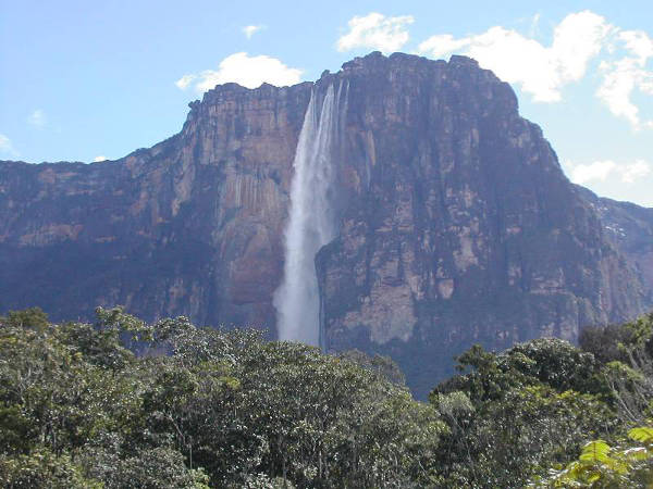
In the 1st place we have the Angel falls.
in the western sector of Canaima National Park, is the Auyantepuy, one of the most famous tepuyes. (The Tepuyes are those flat mountains that end with immense vertical walls.) From that Tepuy is born the Angel Falls (Kerepakupai Vená, in Pemón, which means jump from the deepest place), with its 979 meters of free fall, the highest in the world. Angel Falls has that name, in honor of the man who discovered it in 1937, the American adventurer and aviator Jimmy Angel. However, the natives of the area, the Pemon, already knew it before and had baptized it like Churún Merú.
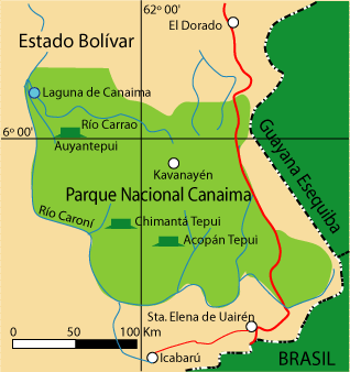
is located in Canaima National Park, in Bolivar State. A protected natural space, established as National Park on June 12, 1962 and DeclaradoPatrimonio of Humanity by UNESCO in 1994, extends over an area of more than 30,000 km², to the border with Brazil and the territory of the Essequibo.
Canaima National Park.
Canaima National Park is the second largest national park in Venezuela and one of the most famous in the country and the world, as there is the largest waterfall known: The Angel Falls, with its almost 1000 meters high. Excursions to the eastern part of the park are memorable and relatively easy to make, as there is a paved road that crosses the park from Puerto Ordaz to Santa Elena de Uairen. Canaima National Park is a national park located in Bolivar State. It was established on June 12, 1962 and declared a World Heritage Site by UNESCO in the year 1994. It extends over 30 000 km² to the border with Guyana and Brazil, because of its size is considered the sixth largest national park in the world. About 65% of the park is occupied by rock plateaus called Tepuyes. These are a unique biological means.
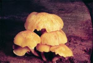
Flora
More than 300 endemic species only in the Gran Sabana. Endemic genera: Achnopogon, Chimantaea, Quelchia, Tepuia, Mallophyton and Adenanthe. Abundant carnivorous species (insectivorous) of the genera: Bromeliad, Drosera, Heliamphora and Utricularia.

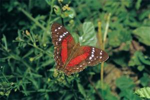
Fauna
Among mammals there are eight species of marsupials, including the Water Puppy (opossum minimus); three-toed sloth (sloth variegatus), Melee Bear (Tamandua tetradactyla), three species of little girls, including Cuspón (Priodontes maximus), currently in danger of extinction. More than 50 species of bats. Numerous carnivorous species such as the Jaguar (Panthera Onca), the Huron (Galictis vittata), the Mapurise (Conepatus semistriatus), the Cuchicuchi (Potos flavus). Among the birds: the Harpy eagle (Harpia harpija), the helmeted copete of Stone (Pauxi Pauxi) and the (Carduelis cucullata), and at least a dozen endemic or restricted distribution species. Variety of poisonous and non-ponzoñozas snakes.
Landscape, Geomorphology and Geology
Landscapes dominated by great forest formations almost impenetrable, very characteristic of the Shield Guayanés. Very impressive is the wide landscape of the Gran Sabana in the Eastern sector of the Park. In Canaima Park are located the highest waterfalls in the world. The high plateaus called tepuyes, are relictos of the old geological formation Roraima, of the Massive Guayanés. The age of these rocks is estimated to be located in the Precambrian, about 3.4 billion years ago. Basic and acid intrusive rocks are observed.
Water resources
The entire basin on the right bank of the Caroní River, the two highest falls in the world, the Angel Falls and the Kukenan and a large number of smaller falls.
Areas of Life
Premontane humid forest and low montane. Premontano dry forest. Tropical Dry Forest.
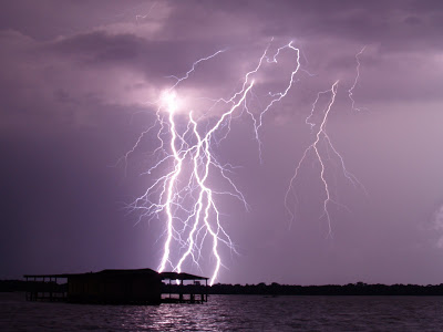
Lightning of the Catatumbo
The Catatumbo lightning is a meteorological phenomenon that occurs in the Lake Maracaibo Basin in Venezuela, mainly in the southern area of the lake and in the lower basin of the Catatumbo River, from which it derives its name. Scientists at the Center for Scientific Modeling indicate that it would be more appropriate to talk about Catatumbo lightning because they tend to occur at multiple sites each night, but from a distance they are seen as a single phenomenon.
This phenomenon is characterized by the appearance of a series of lightning almost continuously and practically silent by the great distances that are needed to observe the phenomenon, which occurs in clouds of great vertical development forming electrical discharges between 1 and almost 4 kilometers Of altitude, as the winds associated with the Low Level Night Jet of the Lake Basin of Maracaibo penetrate in the surface of the lake in afternoon hours (when the evaporation is greater) and they are forced to ascend by the mountainous system Of Perijá (3,750 meters above sea level) and the Cordillera de Mérida, the Venezuelan branch of the Andes (up to 5,000 meters above sea level).
The origin of this phenomenon is in the orographic effect of these mountain ranges that enclose and brake the winds of the northeast; Thus, clouds of great vertical development are produced, concentrated mainly in the basin of the Catatumbo river. This phenomenon is very easy to see from hundreds of kilometers away, as from Cúcuta, in Colombia, or from the lake itself (where there are usually no clouds during the night). Therefore, it is also known as the Maracaibo Lighthouse, since the boats that crossed the area could navigate during the night without problems during sailing. It can occur up to 260 times a year and lasts up to 10 hours a night; In addition, this phenomenon can reach the sixty discharges per minute.
Although it is true that thunderstorms produce a high amount of ozone, and Catatumbo records the world's highest electricity density, with more than 200 km / year, it is very unlikely that this ozone will reach the stratosphere and regenerate ozone layer.
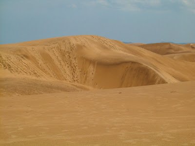
The Medanos de Coro National Park is located in the Falcón state, in the jurisdiction of Miranda, Colina and Falcón municipalities in northwestern Venezuela. The Park is constituted in its greater extension, by the isthmus that unites the rest of the State with the Peninsula of Paraguaná. The park covers an area of 91,280 hectares, of which 42,160 are of continental land and more than 49,120 of marine surfaces.
The Medanos is one of the most important natural representations of the Venezuelan Landscape, they were declared national park the 6 of February of 1974.
In the dunes of Tocópero and Puerto Cumarebo, outside the limits of the park can be observed 'fossil dunes', hills of sandy substrate formed by the compaction of dunes and covered by permanent vegetation. These are of different sizes and show different levels of development of the vegetation, so they probably represent different stages of formation, previous to the current Dune of Choir.
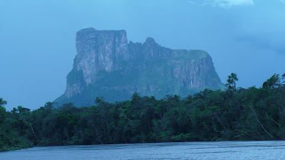
The Cerro Autana
Cerro Autana (the tree of life), is a spectacular tepuy of 1,240 m.s.n.m. Which is located in the Amazon state, east of the Orinoco River and between the Cuao and Autana rivers within the Sipapo forest reserve (Piaroa territory).
Although formed by almost horizontal strata of sandstone, the Autana contains caves and other karst formations, which are rare in rocks that are not limestones. In the upper part, a unique cave in the world formed entirely by cuarsitas, of about 400 meters in length and reaches a height of 40 meters.
This tepuy has been declared Cerro Autana Natural Monument in 1978, including not only the hill, but part of the Autana River and Lake Leopoldo.
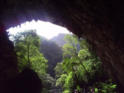
El Guácharo National Park
The El Guácharo National Park is located in the Eastern Interior Serrania, between Monagas state and Sucre state, occupying part of the municipalities Caripe, Acosta, Piar and Bolívar (Monagas) and Ribero (Sucre).
The cave is carved in sedimentary rocks that were formed 130 million years ago in the secondary era in an ancient sea. The Cave has an entrance of 23 meters high and 28 meters wide, in addition to about 10.2 kilometers in length, which is why it is considered one of the most interesting cave formations on the continent.
The natural continuity of the hydrogeological and biological processes that occur in the Cueva del Guácharo are unique and important for which it was declared a Natural Monument in 1949.
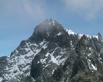
Sierra Nevada National Park
The Sierra Nevada National Park (PNSN) is an important National Park of Venezuela located between the states Merida and Barinas in the west of the country, created on May 2, 1952, which makes it the second national park.
It is the preservation of the highest ecosystem in the country, where the highest mountain ranges of the Venezuelan Andes are located, including Bolivar Peak, the highest geographic accident in the country with 5,007 m.s.n.m.
The park covers part of six municipalities in the states of Merida and three in the state of Barinas. Its total area is 276,446 hectares, of which 185,886 hectares belong to Mérida state, which means 67.2% of the total area, while the rest of 90,560 ha. Correspond to the state Barinas, 32.8% of the surface of the park.
Within this park are the main peaks of the country, such as Pico Bolivar (5,007 masl), Humboldt Peak (4,942 masl), La Concha Peak (4,922), Bonpland Peak (4,883), Espejo Peak 4,880), the Leon Peak (4,740), the El Toro Peak (4,729) and the Mucuñque Peak (4,609).
Every Venezuelan feels very proud of his country to possess such wonders and we do not need to go far to admire the beauty that nature gives us, Venezuela has deserts, snowy peaks, jungles, forests, seas. Nature was very generous with our country giving us a bit of a dent.
Source of text and images:
Http://venezuelatuya.com/canaima/saltoangel.htm
Https://en.m.wikipedia.org/wiki/Salto_%C3%81ngel
Looks like an fascistic please to visit!
I've never been to South America! It is on the bucket list and moving closer to the top!! Thank you, @enrikeprez, I'm following you!
I have been able to visit a few of these wonders, I recommend them a lot, I assure you that when you visit the memories you will never forget them.