
The Water of Leith - Edinburgh’s Waterway of Life
Unlike many ancient cities, Edinburgh was built without many of the essential features which help to sustain substantial populations.
Unlike many ancient cities, Edinburgh was built without many of the essential features which help to sustain substantial populations. The city lies too far inland to have a natural port of its own, on too mountainous a landscape to provide land for grazing animals or planting crops, and wasn't on any major waterway to provide access for industry or shipping.
But many of these features lay just beyond the bounds of the original city. The port of Leith, at one time the busiest port in Scotland, developed as a separate town, and was only formally incorporated into Edinburgh in the 20th century. Farmland to the south, east and west sustained agricultural communities who came to Edinburgh to trade their goods and produce.
And the Water of Leith, a modest stream running from the Pentland Hills into the North Sea at Leith, was a lifeline for many small outlying towns and settlements who used the power the stream provided for industrial operations.
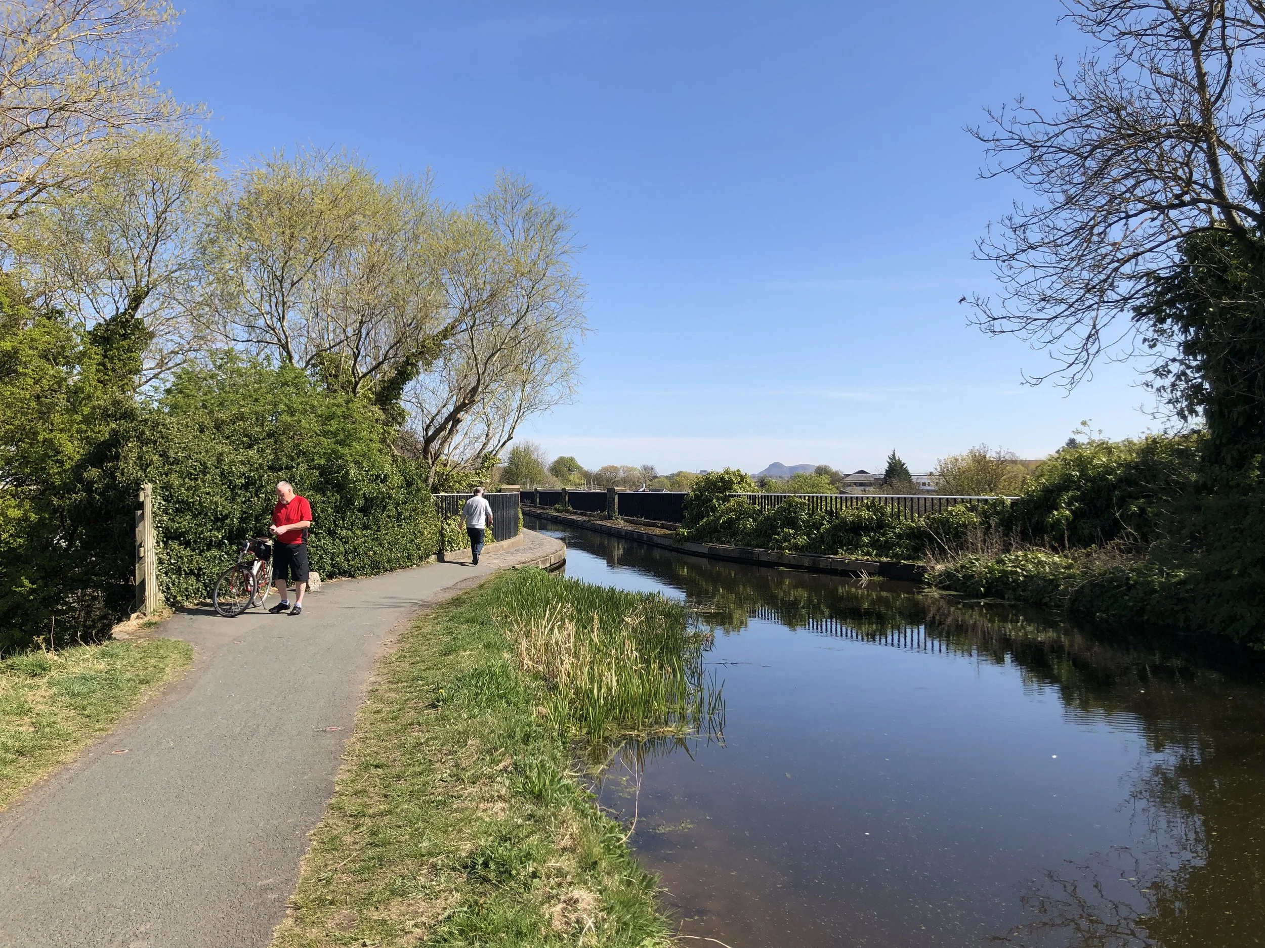
Today the Water of Leith continues to flow through Edinburgh's outskirts and central suburbs, offering a sliver of pastoral idyll to those seeking to escape the city itself. The various former industrial towns are now predominantly quiet residential areas with their own peaceful atmospheres, and a pathway along the length of the river provides a tranquil and accessible route for those looking to walk, jog, cycle or just wander aimlessly through the meandering and sometimes dramatic landscape that the water has carved out over countless millennia.
Here is my guide to some of the highlights found along the Water of Leith, with tips for areas to explore that can take you well beyond the tourist trails of the Old Town. The route as a whole will take you from the high, exposed wilderness of the Pentland Hills, to the former industrial heartland of Leith.

Our journey begins in those hills to the south of the city, where natural gullies gather water from the exposed landscape, and channel it into reservoirs. Some of these provided the original freshwater supplied to Edinburgh, when a network of wooden pipes was established to pipe it into the city in the 17th century.
Other reservoirs provide some of the accumulated supply of water which becomes the Water of Leith itself. There are various areas to explore in the Pentlands, maintained as nature reserves and kept as public spaces, just a short step away from the city centre. Two of the reservoirs which feeds into the Water of Leith are Threipmuir and Harlaw, themselves offering a short circular walking route around the perimeter of these bodies of water, which are often used by anglers.

Harlaw Reservoir
Downstream from these reservoirs, the Water of Leith walkway begins at Balerno, a village which was one of the places which utilised the free flowing waters as a power source for its industry.
Paper mills sprang up around this stretch of Water of Leith in the 18th century with the rise of printed books and newspapers. At one time the river powered in excess of 70 industrial plants along its 24-mile length, producing a variety of materials from paper to flour, all of which could be sold locally or transported into cities like Edinburgh, or even further afield from the port of Leith itself.
Wanderers along the river here may spot a variety of wildlife, from herons and otters occupying the water, to a rich variety of plants growing along the banks of the stream.

Wild garlic is a copious natural foodstuff which thrives in these areas, and in recent years has become a favoured product from those who have turned to foraging for natural ingredients. Look out for brambles and wild berries, as well as orchids, bluebells and a variety of wildflowers among the trees.
A little further downstream, Colinton is another popular suburb which developed around one of the original points where the Water of Leith could be crossed without the need to navigate the treacherous sides of the glen through which the stream ran. Today a high bridge across the water provides a view down to one of the local parks, which remains popular with locals and dog walkers, and onto the Water of Leith walkway which passes through it.

Colinton village
Colinton has several associations with the writer Robert Louis Stevenson, who often stayed with his grandparents in the village and spent time playing along the banks of the river, later taking inspiration for his poetry from these idyllic childhood times.
From Colinton walkers have a choice of following the path along the banks of the water, or traversing a higher path which runs along the route of a former railway.

Along the railway route is a tunnel cut through the rocky sides of the valley. Today the tunnel has become a popular public work of art, with the walls painted with a variety of popular Scottish icons and imagery, including Harry Potter figures, Highland cows, a bagpiper and military memorial plaques, and a graffiti-style rendering of one of Robert Louis Stevenson's poems, From a Railway Carriage, describing the features glimpsed from a speeding train!
The Colinton tunnel is a real highlight of this route, and makes it worth leaving the water briefly to climb a little higher - and from here you have another choice, to return to the valley and follow the bank of the river, or to stay above it where you'll join with the Caledonian Canal, another of the waterways which cuts through this landscape.
Union Canal crossing Water of Leith
From the canal route you'll be rewarded eventually with an elevated view across towards Arthur's Seat in the distance, as the canal is carried over an aqueduct which crosses the Water of Leith itself.
From here you can descend a steep staircase to get back to the river, and take advantage of the Water of Leith Visitor Centre, where you can find out more about the work done by the Water of Leith Conservation trust to protect and preserve this historic waterway, and recharge your batteries with a coffee from their cafe.

The visitor centre, where the canal crosses the river, is at Slateford, which was historically another town with important transport links - at one time, the road, railway and canal were all viable routes through this area, and the railway bridge and aqueduct which rise high above the level of the road and the Water of Leith are a reminder of this area's former industrial heritage.
At this point we're only about 3 miles from the centre of Edinburgh, yet walking along the Water of Leith feels as though we're in a remote countryside setting. The landscaping and foliage muffles any noise of traffic and industry, and on a warm day the noise of birdsong is easily the loudest sound you'll hear.
From Slateford, the Water of Leith continues through the suburbs of Saughton, Roseburn and Murraryfield (home to Scotland's international rugby stadium), a relatively flat plain of Edinburgh developments that are occasionally vulnerable to flooding when the river is in full spate.
But continuing our walk along it, it's not long before the landscape changes again and becomes a steeper ravine, as the Water of Leith enters another former industrial area, at the Dean Village.

Dean Village
This was once a busy mill town on one of the only major routes into Edinburgh. Farmers from all around the city could bring their grain here to be turned into flour which was then exported into Edinburgh itself.
As well as the original arched bridge crossing the river, Dean Village has several reminders of its original status, including the hall of the guild of baxters (bread bakers). Today it's a peaceful residential area with access directly to the Modern Art Gallery from the Water of Leith walkway itself.
Dean Village is a popular area for visitors to explore, just a short walk from Princes Street, and featuring in my New Town fixed-route tour.
Between the Dean Village and Stockbridge, another of Edinburgh's popular and bustling suburbs, the Water of Leith path runs in a steep valley whose sides are laid out with New Town private gardens. This was at one time an extremely wealthy, high-status residential district, developed as Edinburgh grew in the 18th century.
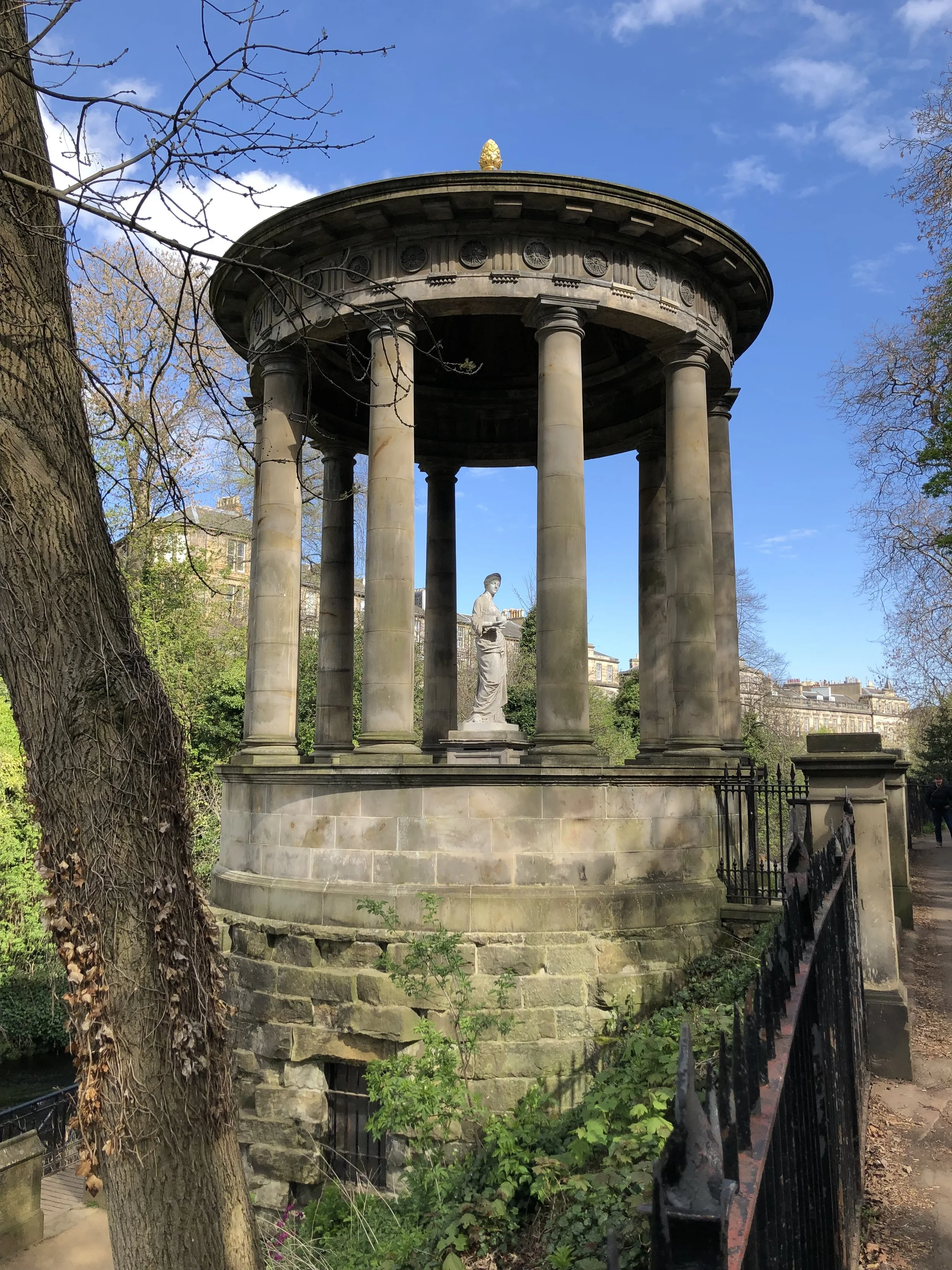
St Bernard’s Well
Although the industrial usage of the stream had left the water badly polluted and filthy - granting it the evocative local nickname 'Tumbleturd' - this remains one of the most picturesque and popular sections of the river. Look out for the neo-classical Grecian temple of St Bernard's Well, a former mineral spring which attracted visitors in the early days of Edinburgh's tourism trade.
From Stockbridge the Water of Leith runs near to the Royal Botanic Gardens, a pleasant haven of green space just a short walk from the city centre. The area nearby is known as Canonmills, after the historic location of mills (powered by the Water of Leith) which were managed by the canons of Holyrood Abbey, and from which the church derived a significant income.
Little evidence of these industrial features survive, but as the stream continues through Bonnington - once a settlement straddling the boundaries of Leith and Edinburgh - you may still see heavier industrial occupation of an area which capitalised on both the power supply of the stream and the proximity to the port for overseas trade and export.
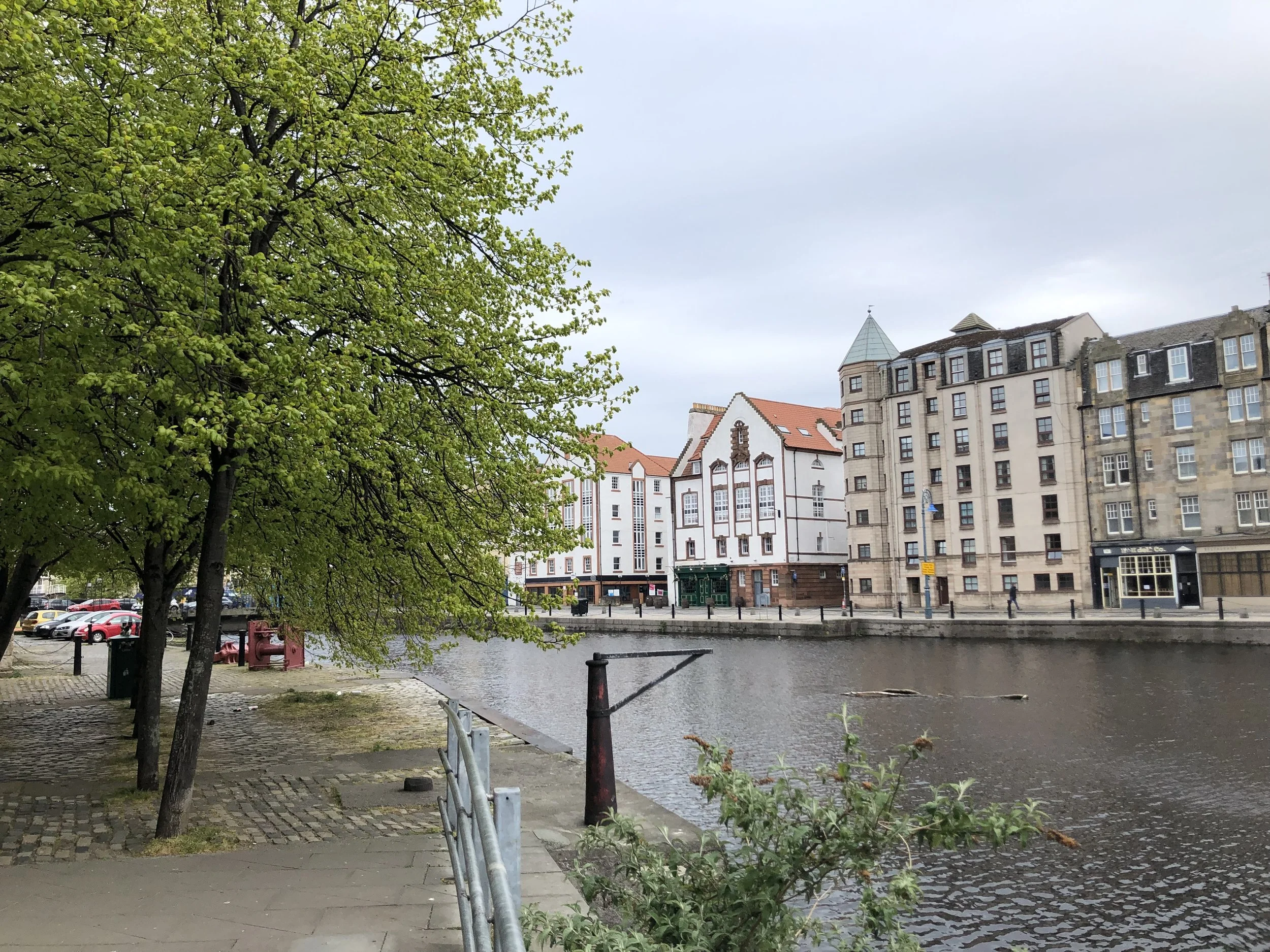
The river widens as it enters its final stretch, taking us into the original port area of Leith.
The atmosphere as you walk along the banks here is distinctly post-industrial, with many of the old riverside buildings replaced with modern accommodation blocks, or converted into commercial spaces.
Reminders of the heavily industrial history of Leith are not hard to find, from large anchors set into the pathways to fish-based sculptures around the network of small streets immediately adjacent to the water. And it's not hard to miss the evidence of a huge amount of financial support invested in the area to regenerate Leith over the last two decades.
What was once a rundown port district, which had gone into decline with the loss of shipping and associated industries in the last half-century or so, is now a vibrant town with a fantastic array of local shops, cafes, bars and restaurants which has earned it recognition as a haven for hipsters.

But there is history in these streets and buildings, too. Look for the former St Ninian's church, one of the oldest surviving buildings in Leith, which stands almost directly on the bank of the Water of Leith.
Originally founded in the 1490s, the structure today features stonework erected during a post-Reformation renovation at the turn of the 17th century, as well as later additions like the Dutch-style bell tower.
What was once the port area itself is now known as the Shore, and more history can be found amongst the modern businesses which occupy some of the older buildings.
The Malmaison boutique hotel occupies the former Sailor's Home, a seamen's mission built to accommodate sailors whose ships were moored in the port in front of it, and in front of it is a memorial to merchant navy men whose lives were lost in a variety of conflicts and incidents.

Nearby is the remains of a windmill built in the 17th century by the architect Robert Milne, which was converted into a signal tower during the Napoleonic Wars, and a whaling harpoon is mounted at the side of the port as a reminder of the commercial trading which once took place in the water here.
The whole area oozes atmosphere, and it's perhaps strange to think that was was once a noisy, dangerous, busy industrial town is today a destination for brunch!
For anyone undertaking a walk along the length of the Water of Leith, arriving here - a little over 12 miles since starting along the pathway inland back at Balerno - offers plenty of choice for rest, relaxation, and refuelling.
Beyond a renovated swing bridge which would once have opened to allow large ships into the port, a tangle of ironwork and shipping cranes acts as a reminder that the North Sea - still a busy shipping lane and fishing territory - is just a short paddle away.

Port of Leith
But how different the landscape is here, compared with the high, isolated mountain moorland where the Water of Leith began! In a relatively short distance we have traversed a variety of Edinburgh's suburbs and historical features.
From the sailors and fishermen of Leith to the well-heeled society folk of the New Town, and from the paper mills of Balerno to the baxters of Dean Village, over time the Water of Leith has provided a focus to a varied cross-section of people and industries. Today it's the domain of dog walkers and joggers, cyclists and casual strollers.
And still the water flows on, oblivious to the changing fashions, functions and tides of human occupation...
