Estimated read time: 4-5 minutes
SALT LAKE CITY — Snow and sub-freezing temperatures remain in Utah's forecast this week; however, Utah may avoid a blast of arctic air forecast to provide "bitter cold" temperatures in parts of the West this week.
The National Weather Service on Monday issued yet another set of winter storm warnings and weather advisories for northern Utah, where a pair of storm systems are expected to dump more than 2 feet of snow in the Wasatch and West Uinta mountains between Tuesday and early Thursday. The storms may also produce several inches of snow in the valleys, as well.
High temperatures may top out in the upper 20s and low 30s along the Wasatch Front and northern Utah this week, but newer long-range models indicate even colder temperatures may end up landing east of the state, sidestepping Utah altogether, according to KSL meteorologist Matt Johnson.
Heavy snow in the forecast
Then series of storms that arrived last week ended up dumping as much as 3½ feet of snow at Brian Head Resort in southern Utah and more than 2 feet of snow at Alta and Snowbird resorts in the Wasatch Front, as well as close to 6 inches of snow in places like Salt Lake City, according to the National Weather Service.
Snowstorms will return to Utah's forecast beginning Tuesday. Johnson says snow will impact northern Utah in the late morning and afternoon before another cold front arrives later, possibly impacting Tuesday's evening commute. Another cold front should come through by late Wednesday afternoon, which may impact the evening commute yet again.
The warnings issued Monday cover some but not all of the projected snow accumulation totals from these two events. They state that 1 to 2 feet or more of snow will fall in the Wasatch, West Uintas and Wasatch Plateau/Book Cliff mountains between Tuesday and 5 a.m. Thursday, while 10 to 18 inches of snow are forecast to fall within Wasatch Back communities during that same time.
The advisories state the following:
- 6 to 12 inches of snow in the central mountain by 5 a.m. Thursday.
- 5 to 12 inches of snow in northern Utah by 5 a.m. Thursday.
- 3 to 7 inches of snow along the Wasatch Front, Tooele Valley and central Utah valleys by 5 a.m. Thursday. Higher totals are expected in bench areas.
Additional snow is expected after 5 a.m. Thursday, which may increase final snow accumulation totals.
The weather service warns snow squalls are possible on Tuesday and "travel could be very difficult to impossible" at times throughout Utah's northern half, between Tuesday and Thursday.
The storms should help boost Utah's snowpack, which gained 0.7 inches statewide after last week's storms, according to Natural Resources Conservation Service data. Snowpack remains at 74% of normal for this point of the year, up from 69% last week.
Another storm is slated to impact Utah over the coming weekend, before the storm activity begins to slow down, Johnson said. Snow projections from the third system will become clearer closer to its arrival.
"I think as we get into next week, models — on the average — are suggesting a quieter setup," he added.
Cold temperatures linger
Sub-freezing temperatures are also forecast to linger throughout this week. The storms are originating in Alaska, which is why valley temperatures will remain in the 20s and 30s, with overnight lows dipping into single digits and teens multiple days this week, Johnson said.
That will likely trigger more Code Blue alerts across the region, which set off a series of emergency protocols tied to homeless resources.
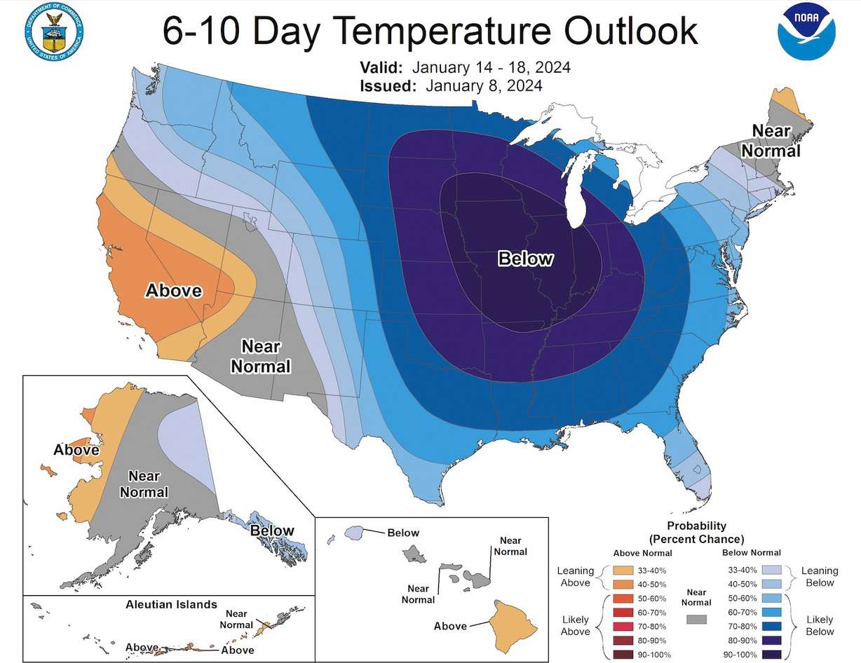
Even colder temperatures could still be on the horizon, but it does appear Utah will avoid an "arctic blast" forecast to arrive across the U.S. early next week.
The National Weather Service Climate Prediction Center issued a notice Friday, saying a pair of high-pressure systems forecast to set up over Greenland and Alaska will push "a widespread cold air outbreak" toward the U.S., which will bring temperatures and wind chills "well below zero."

Northern parts of the Intermountain West and the Central Plains are most likely to be impacted by the "bitter cold" air, the alert states. Utah was originally at the center of this cold blast, but Johnson says newer, long-range models indicate the brunt of the cold air may fall east of the Beehive State.
"We could tap into some cold, dry Canadian air early next week. If that happens — if we get a little component of that arctic air — obviously, it'd be a moderated version, but that would put into the low-teens, maybe some single-digits for spots (overnight)," he said. "The coldest temperatures will be found late this week, early next week and the overnight lows could get brutal."
Full seven-day forecasts for areas across Utah can be found online, at the KSL Weather Center.


