Article

Wetland Raised-Field Agriculture and Its Contribution to Sustainability: Ethnoecology of a Present-Day African System and Questions about Pre-Columbian Systems in the American Tropics

1
Centre d’Écologie Fonctionnelle et Évolutive (CEFE, UMR 5175), CNRS, University of Montpellier, University Paul Valéry Montpellier 3, EPHE, IRD, 1919 route de Mende, 34293 Montpellier, France
2
Laboratoire Ecologie, Environnement, Interactions des systèmes amazoniens (LEEISA, UMR 3456), CNRS, University of Guyane, Ifremer, Centre de recherche de Montabo, 97334 Cayenne, French Guiana
*
Author to whom correspondence should be addressed.
Sustainability 2018, 10(9), 3120; https://doi.org/10.3390/su10093120
Submission received: 31 July 2018 / Revised: 14 August 2018 / Accepted: 28 August 2018 / Published: 31 August 2018

Abstract

:
One adaptation for farming wetlands is constructing raised fields (RF), i.e., elevated earth structures. Studies of RF agriculture have focused mostly on the vestiges of RF that were cultivated by pre-Columbian populations in the Americas. Ironically, whereas RF agriculture is still practiced nowadays in many parts of the world, including the Congo Basin, these actively farmed RF have received scant attention. Yet, studying how RF function today can shed new light on ongoing debates about pre-Columbian RF agriculture. Also, in a context of climate change and widespread degradation of wetlands, the study of RF agriculture can help us evaluate its potential as part of an environmentally sustainable use of wetlands. We carried out an ethnoecological study of RF agriculture combining qualitative and quantitative methods over a total of eight months’ fieldwork in the Congo Basin. We found that RF show great diversity in size and shape and perform several functions. Incorporation of grasses such as green manure, allows RF to produce high yields, and RF agriculture decreases flooding risk. However, it is labor-intensive and is likely always only one component of a multi-activity subsistence system, in which fishing plays a great role, that is both resilient and sustainable.

1. Introduction

Inland wetlands, encompassing either permanently or temporarily inundated areas, are estimated to cover more than 950 million hectares in the world [1], an area almost as large as the United States. They include some of the most productive ecosystems in the world [2,3]. In particular, the floodplains of major rivers such as the Tigris, Euphrates, Ganges, Nile and Huang He have long attracted human settlement, and have favored the development of agriculture [4,5]. Human populations have developed diverse cultural adaptations to cultivate alluvial plains and decrease the risks of crop loss due to flooding (for a review, see [6]).
One adaptation for cultivating in flooded environments is the construction of raised fields (hereinafter noted RF), defined as “any prepared land involving the transfer and elevation of earth in order to improve cultivating conditions” [7] (p. 24). Ironically, although RF agriculture is still actively cultivated in some parts of the world, most of our knowledge on RF is based on studies undertaken in the Americas, where most RF fell into disuse at least 500 years ago.
In South America and Central America, large areas of wetlands across a great range of environments, both highland and lowland, are occupied by vestiges of pre-Columbian RF (Figure 1). The construction and abandonment of RF in the Americas are spread over time. The oldest known vestiges of RF were constructed as early as 1000 BC, in the northern floodplains of Lake Titicaca, while the construction of RF in other sites of Lake Titicaca is dated at around 1000–1400 AD [8]. In the Bolivian lowlands some raised fields have been dated back to as early as 600 AD [9]. Until now, most directly dated vestiges suggest that RF in the Bolivian lowlands were abandoned before the European contact or just shortly after conquest [10]. However, one study in the Llanos de Moxos in Bolivia suggests that some RF were in use until 1800 AD [11].
Pre-Columbian RF in the Americas show great diversity in morphology and size. They can be round, rectangular, linear, or curvilinear [12,13,14,15]. Some are quite small (i.e., as small as 0.5 m diameter for some round mounds in French Guiana), while others (elongated ridges or platforms) can measure up to several km long [14,16]. RF are also highly diverse in their orientation relative to topographic gradients (parallel or perpendicular to slope) [13] and in their spatial organization [10].
The total area covered by vestiges of RF is difficult to measure exactly. Of the numerous sites shown in Figure 1, for three large, relatively well-studied areas, pre-Columbian RF are estimated to cover approximately 200,000 ha in the Rio San Jorge Valley in Colombia, 82,000 ha around Lake Titicaca in Peru and Bolivia [6] and at least 57,500 ha in the Llanos de Moxos in Bolivia [10].
Following the pioneering work of Denevan [19] in the Llanos de Moxos, many archaeologists, geographers, ecologists and anthropologists have shown great interest in studying the vestiges of RF in different wetlands of the Americas to better understand how this agricultural system may have functioned (e.g., [9,14,20,21,22]). These studies have led to lively controversies. Among the most debated and still unresolved questions, which are summarized in [23,24], are the following:
  • Why do RF show such great diversity in shape, size and organization and to what extent is their design an adaptation to environmental (e.g., edaphic, hydrological or topographic) conditions (see [10] for a summary)?
  • Why were RF built, how were they managed and how important was nutrient management in RF agriculture (see [25] for a review of these questions)?
  • How productive was RF agriculture and how many people could it have sustained (see for example [14,26,27])?
  • Why were RF in the Americas abandoned (see [28,29])?
The arguments used in these discussions are based on (i) archaeological, geoarchaeological and archaeobotanical studies; (ii) experimental studies aimed at replicating RF or rehabilitating old RF to test the benefits they confer and evaluate their productivity [20,30]; and (iii) observations of still-cultivated systems that present similarities with ancient RF, in particular the chinampas in the valley of Mexico. The chinampas are one of the rare systems of RF agriculture in the Americas that have persisted until today [6,31]. However, this form of lacustrine wetland agriculture, where channels are always filled with water, differs greatly from other kinds of RF in seasonal floodplains (for reasons outlined in [23]) and this model should not be overgeneralized [32,33,34]. Despite advances based on these three sources of data, there is still no consensus about how pre-Columbian RF may have functioned.
This incomplete understanding of RF agriculture is at least partially attributable to the lack of studies that describe how RF are used today. Despite the fact that RF are still farmed nowadays in many parts of the world, including Africa, Asia and Oceania [6,7,32,35], RF in these regions have received only little interest until now.
Studying RF agriculture in the Old World and Oceania can provide closer analogues to pre-Columbian RF agriculture, in terms of ecological context, than do the chinampas. Although environments and the cultural inventions devised to overcome environmental constraints will both vary among particular situations, investigating RF still in use by humans provides new information on the functioning and agronomic potential of RF agriculture that is beyond the reach of archaeological methods.
Denevan and Turner [7] were the first to suggest that we would gain better insight by studying actively farmed RF. They reviewed the literature mentioning the presence of RF in the Old World and Oceania, and underlined the scant attention paid to these agricultural systems. In the cuvette centrale of the Congo Basin, where we conducted our study, we found only a few notes concerning RF agriculture in fairly old monographs [36,37,38,39,40] as well as aerial photos (from the 1960s) and satellite imagery (inspected using Google Earth), which attest to the presence of RF in several sites (Figure 2). The authors of the old studies described landscapes composed of RF sometimes covering large areas, and sometimes gave limited information on farming practices, but none of them provided much information about the functioning of RF. As the Congo Basin is the world’s second largest river basin after the Amazon, draining around 3.7 million km2 [41], one can only be surprised by this scant interest, in comparison to the rich literature on pre-Columbian RF in the Amazon Basin and elsewhere in the Neotropics.
Only two recent studies [23,24] have aimed to fill this gap, examining the functioning of RF agriculture in two locations within the Congo Basin, the cuvette centrale in the Republic of Congo and the Bangweulu wetlands in Zambia. Here, we present an ethnoecological study of RF agriculture as it is practiced today in the wetlands of the cuvette centrale. The ethnoecological approach focuses on the interactions of human societies with their environment by combining both social and ecological data. This approach allowed us to gather information on the knowledge, practices and worldviews of farmers and on the functioning of floodplain environments. More specifically, our study has two main objectives. Firstly, it provides new insights on the aforementioned four main questions that are still debated by scholars concerning pre-Columbian RF in Central and South America. Secondly, it focuses attention on present-day RF agriculture in its own right, as a little-investigated but perhaps promising way of farming wetlands without destroying them. We discuss the potential of this agricultural system as part of an environmentally sustainable use of wetlands. This last point is of particular importance, as wetlands are today under threat, mainly through clearing and drainage, often for conversion to intensive agriculture [3].

2. Materials and Methods
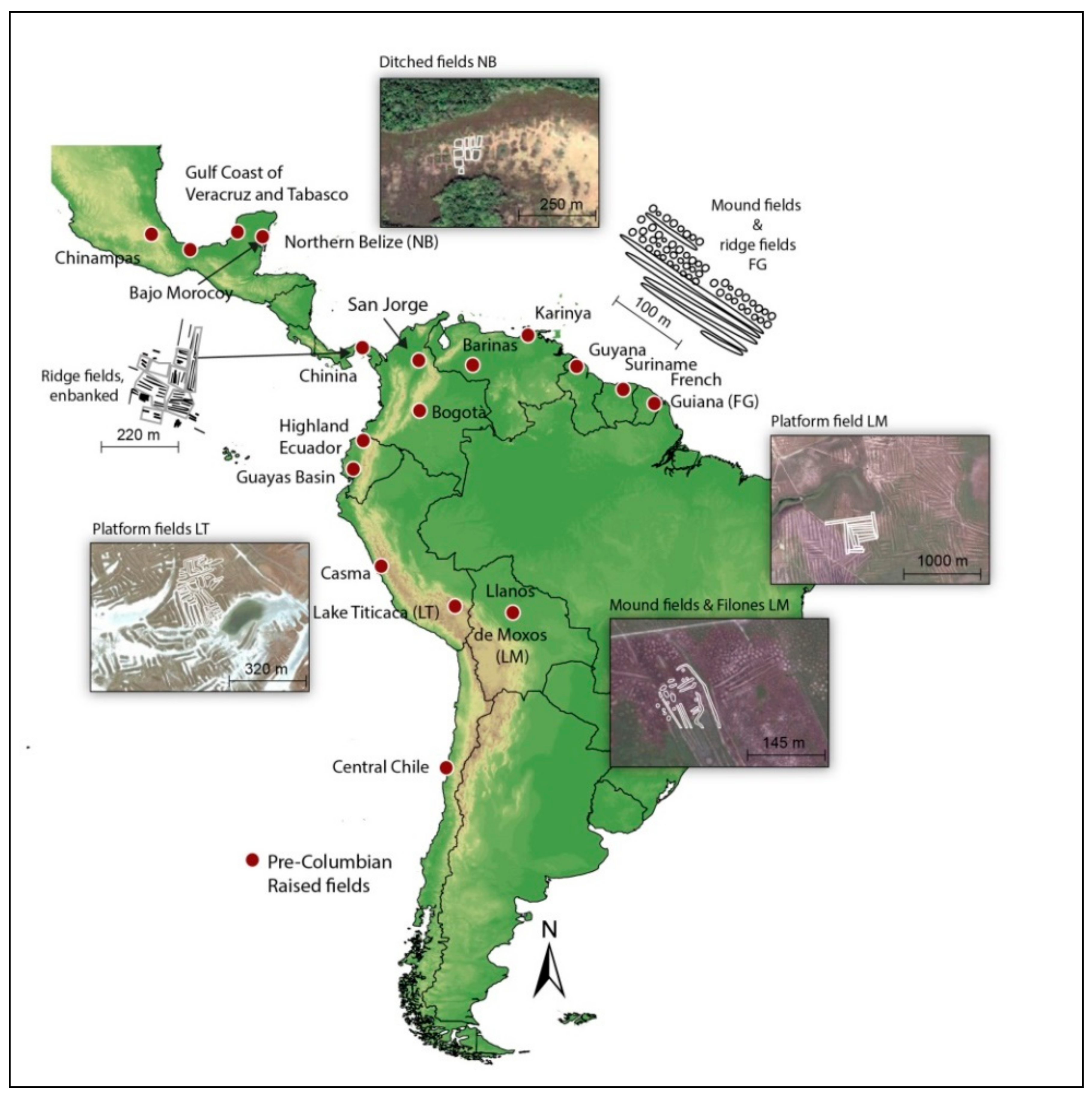
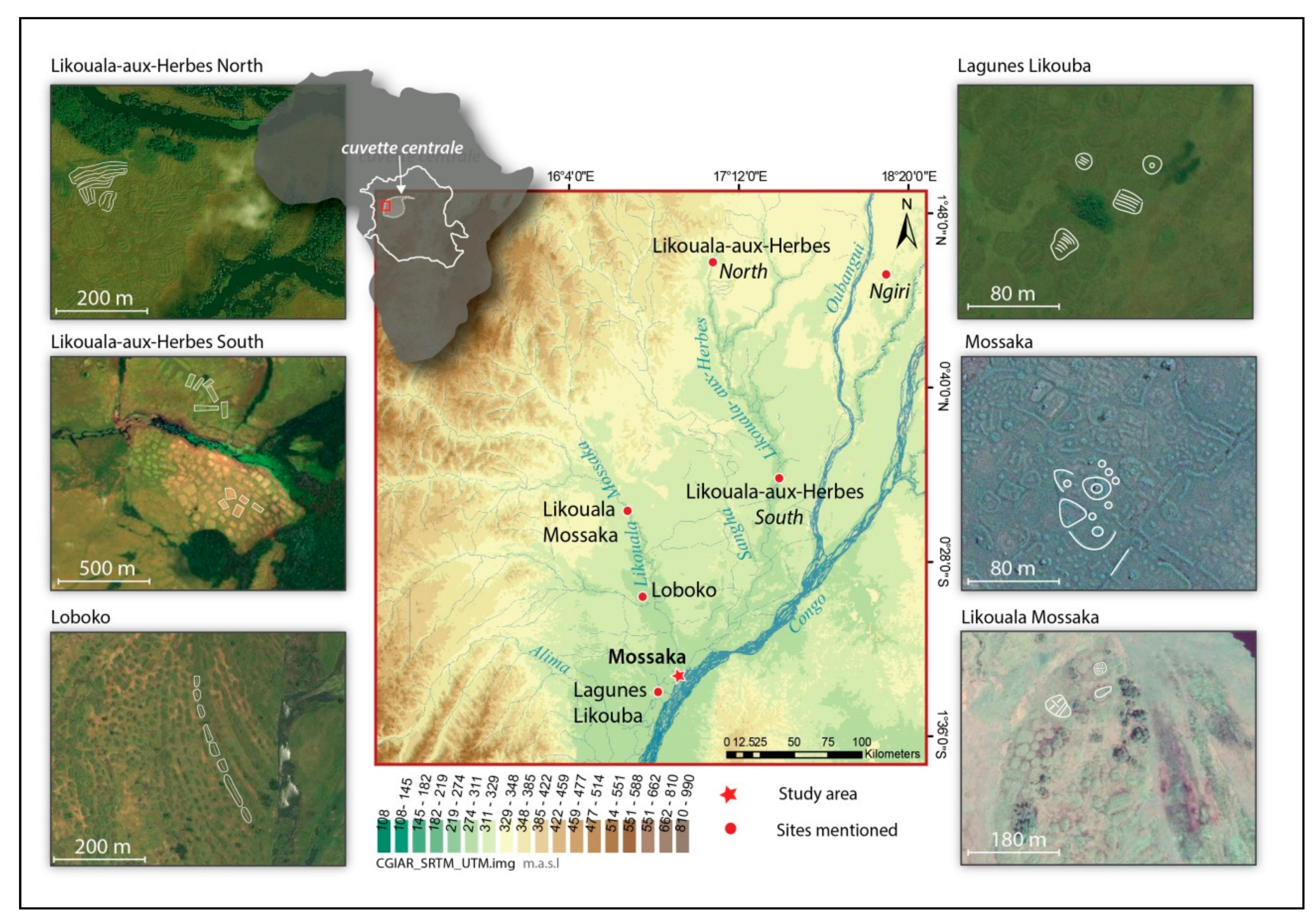
2.1. Study Site

The cuvette centrale is a vast depression spreading over almost 200,000 km2 within the Congo Basin, the forests and grasslands of which are periodically submerged due to local rainfall and to the rising water level of the Congo River and its numerous tributaries [41,42]. The study was conducted in the city of Mossaka, the lowest-lying city in this vast depression (Figure 2). The grassland floodplain near Mossaka is flooded once a year, during the major rainy season locally referred to as pela. Water begins to rise in September, and by the end of November the floodplain is completely submerged, with water more than 1.5 m deep in some sites. In January, when the minor dry season (mwanga) begins, water recedes from the floodplain and only some permanent pools and channels remain filled with water. A less intense rainy season (ndzobolo) occurs from April to June but the water level at that time is not high enough to flood the plain.
Mossaka was sparsely populated until the end of the 19th century. People were concentrated in villages further from the Congo River, in which RF cultivation was often common, as in the lagunes Likouba and Loboko (Figure 2). The village of Mossaka, chosen in 1912 as the local seat of the colonial administration, started to grow during the colonial period as residents of the surrounding villages were forcibly resettled. Owing to ongoing rural exodus, now driven by economic factors, Mossaka has continued to expand, from 6000 inhabitants in 1981 to 15,000 today [43]. RF cultivation in Mossaka first expanded as the number of inhabitants increased, until the progressive decline of this agricultural system in the last 30 years. Some RF in the floodplain near Mossaka are now overgrown by vegetation, having lain fallow for long periods or even having been apparently definitively abandoned. However, others are still actively cultivated. We gathered data to better understand the functioning of RF agriculture in Mossaka, its role in people’s livelihoods, and its dynamics.

2.2. Methods

The field study was conducted by the first author (M.C.) in Mossaka over a total of eight months in the years 2014 and 2015. Along with participatory observation in farmers’ fields, we conducted a total of 179 semi-structured interviews with 53 persons, 15 of whom were actively engaged in cultivation of RF. We asked questions related to the knowledge, know-how and worldviews of RF farmers, but also about other subsistence activities practiced in Mossaka, such as fishing. We also addressed questions concerning how life, livelihoods and the organization of subsistence activities in Mossaka have changed in recent memory. We were careful during the discussions to allow the interviewees to bring new ideas and topics. To gather more accurate details, some key informants were interviewed several times. All interviewees gave their informed consent for inclusion before they participated in the study. The interviews involved no collection or processing of personal data. The study was conducted in accordance with the RESPECT Code of Practice for Socio-Economic Research, whose guidelines form the basis of a voluntary code of practice covering the conduct of socio-economic research by institutions in Europe. The research was approved by the Ecole Doctorale GAIA, Montpellier. Interviews were conducted in French and all quotations in this paper are translated by the authors from French. Vernacular terms in this manuscript are given in the Likouba language (Group C27 of the Guthrie Classification of Bantu languages [44]) and written phonetically using the International Phonetic Alphabet, without mention of the tonal accents. When a plural form exists, it is specified in parentheses.
During field study, we also assessed the yields of manioc (Manihot esculenta Crantz [Euphorbiaceae], also known as cassava) in RF. Manioc is the predominant crop cultivated on RF and its tuberous roots (henceforth termed ‘tubers’ for the sake of brevity) are harvested throughout the year. Since we were not continuously present in Mossaka, we asked two farmers to weigh (using scales we provided) all tubers gathered in their RF during the year 2014. One of the farmers had two RF and the other one eight RF. We then measured the area of the fields harvested using a measuring tape. Calculation of the yield of RF agriculture requires taking into account two facts: (1) RF occupy only part of the total area required by the system, which also includes interspaces between RF. (2) RF are not used continuously, but are left fallow between periods of use. To consider the first fact, we made the distinction, as recommended in [26,45], between gross yield and net yield. These authors defined net yield as the yield provided by the planting surface of the field only (i.e., the RF). Gross yield takes into account the fact that RF comprise only a proportion of the total area required by the system, i.e., RF plus interspaces. To account for the existence of fallow periods, we recorded the fallow/cultivation calendar reported by eight farmers. Using all these data, we obtained a fallow-corrected gross yield (Table 1).

3. Results

Results are organized in this section following the framework of the four main relevant questions on RF agriculture that we presented in the introduction.
Based on analysis of satellite images available through Google Earth, RF are found within an area of approximately 200 km2 in the region of Mossaka. We could not determine when the RF that are observable today were constructed, but it is likely that these structures began to be built as soon as farming peoples arrived in the area, probably around the 17th and 18th centuries AD [38,40].

3.1. Diversity in the Shape, Size and Spatial Organization of RF

RF around Mossaka show considerable diversity in shape and size, even within a relatively small area. The height to which people choose to construct them depends on the water level reached during the major rainy season pela, and varies mostly between 0.5 and 1.5 m, with an average of 0.9 m (from eight measured RF). The inhabitants of Mossaka classify and name the RF according to their form, and assign them different functions and particularities. Based on the local names, we identified four main categories of RF (Figure 3).
  • Circular RF, named lianga (pl. maanga), are frequently found (Figure 3A). They can reach more than 20 m in diameter. According to our interviews, an important advantage of these round RF is that they can be easily converted into habitable plots. Before 1967, when a large dredge began pumping sand from the Congo River to elevate the city site and protect it from flooding, high ground was scarce. At that time, houses were built on raised mounds that had first been cultivated as circular RF. Note that the amount of sand dredged from the river can be seen in satellite images, where the white sand on which Mossaka has been built is strikingly evident.
  • Other RF take the shape of a crown (round or rectangular) or a horseshoe. They are called molingu (pl. milingu) (Figure 3B). When horseshoe-shaped, these RF can serve as fish traps. At the end of the major rainy season pela, when water recedes from the floodplain, and along with it the fish that reproduced and fed there during the high-water season, fishermen put a basket trap (called boloko) across the opening of a molingu to capture fish that had ventured inside. This fishing technique was already described by Sautter [38]. Fish can also be captured by hand inside the basin formed by the molingu with the help of a woven basket eyika (pl. biyika). These RF can also be easily converted into a house site by filling the central part with earth.
  • We also observed elongated ridges of varying length and breadth, some measuring more than 30 m long and 2.5 m wide. These RF are commonly designated by the word mondzeke (pl. mindzeke), but some people distinguish between two types, mosambuku (pl. misambuku) and ekoti (pl. bikoti), the latter being broader than the former (Figure 3C). Elongated ridges can be used to demarcate borders between two fields. They are sometimes elbow-shaped, following these borders.
  • Some RF, called mombaka (pl. mimbaka), look like a crescent moon (Figure 3D). They are often built around the elongated ridges and can demarcate the frontier of the fields.

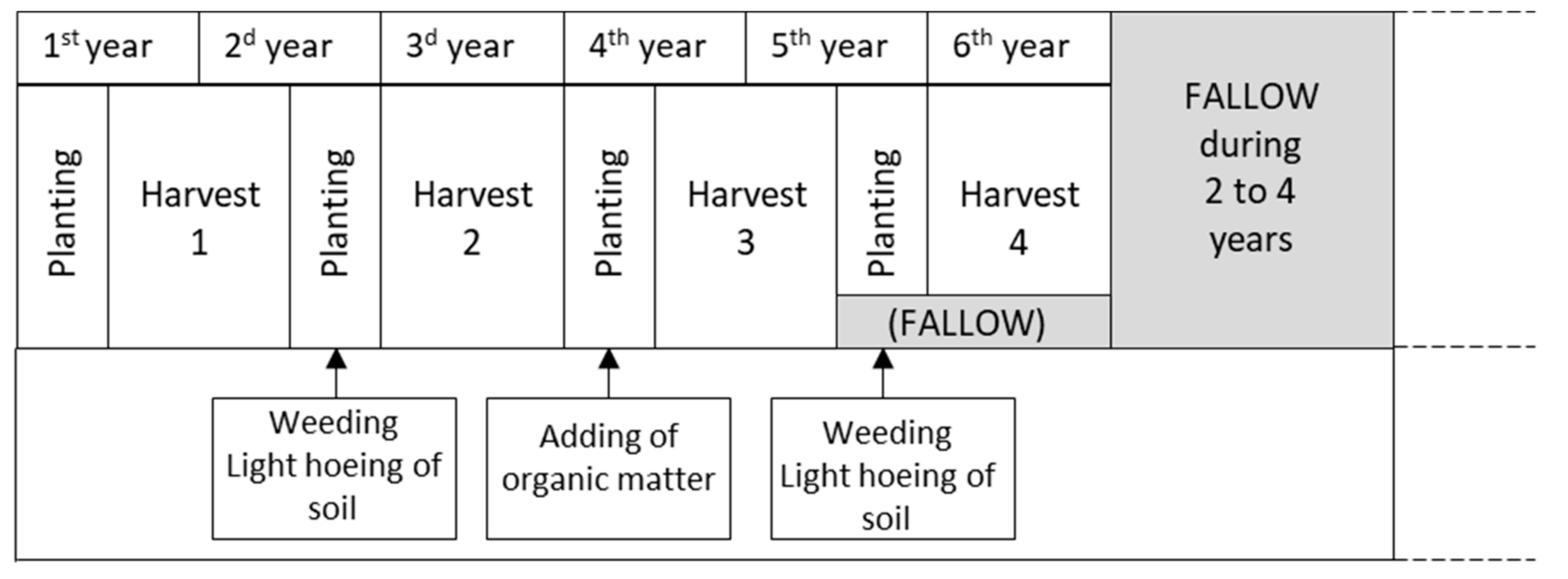
3.2. Construction, Functioning and Management of RF

In Mossaka, as in the Congo Republic in general, agriculture is mostly a feminine activity [46]. Construction of RF, like all other agricultural tasks, such as weeding and harvesting, is often done by women working alone, but other family members (husband, mother, sisters, children, etc.) can help occasionally. Access to land for RF cultivation is regulated by the rule of the ‘first occupant’: a person can establish a field in any place of his/her choice that has never been cultivated. In Mossaka, the distance from the city seems to be the first criterion of selection for a site. Today, one needs to walk sometimes more than an hour from the city to find an uncultivated place.
RF can be constructed at any time of the year, except during the major rainy season pela when the floodplain is inundated. Construction of a RF begins with the digging up, using a hoe, of clumps of vegetation, mostly the grasses likinga (pl. makinga) (Phacelurus gabonensis [Steud.] Clayton, commonly known in the literature as Jardinea congoensis) and litsie (pl. matsie) (Hyparrhenia diplandra [Hack.] Stapf), along with the earth clinging to their roots (Figure 4A). These grasses are dominant in the floodplain and have long stems and dense, tough roots that hold soil. The clumps of earth are placed so as to form the desired circumference of the field, then piled up on top of each other to create a wall, the aerial parts of the grasses being always oriented inwards (Figure 4B,C). Loose fill vegetation and soil are then added in the interior to fill up the gap, and a last layer of topsoil, free of vegetation, is finally added to cover the field (Figure 4D). Cultivation begins soon after the field is built (Figure 4E). As noted above, manioc is the major crop grown on RF (Figure 4F).
We identified 27 named landraces of manioc cultivated on RF by the farmers of Mossaka. Most are bitter landraces that require processing of the tuberous roots. Other crops grown in addition to manioc include sweet potato (Ipomoea batatas Lam.), Guinea sorrel (Hibiscus sabdariffa L.), sugar cane (Saccharum sp.), pineapple (Ananas comosus [L.]) Merr), banana (Musa sp.), maize (Zea mays L.), peanuts (Arachis hypogaea L.), okra (Abelmoschus esculentus [L.] Moench), pepper (Capsicum sp.), amaranth (Amaranthus sp.), eggplant (Solanum melongena L.), tomato (Solanum lycopersicum L.) and others.
Once all crops on the RF have been harvested (usually after one or two years), the field can be planted a second time. No organic matter is added at this stage, as the soil is considered to be still sufficiently fertile: “After the first harvest, when you plant the second year, you do not need grass”. In addition, the grasses likinga and litsie in the areas around RF are still too small and sparse to be dug up and added to fields. Thus, after the first harvest, RF are only weeded and the surface soil gently hoed. After the second harvest, however, the RF must be enriched before further cultivation. Grasses in the interspaces have grown sufficiently to be dug up. Following the same procedure as in the construction of a new field, grasses and the clumps of earth clinging to their roots are dug up and piled on top of the RF. The addition of soil and vegetation renews the fertility of RF and maintains or increases the desired diameter and height of the fields, which have been eroded by rains and floods.
RF are harvested three or four times over a period of 5–6 years of cultivation. Then, when farmers note a decrease in the size and number of manioc tubers, the RF is left to fallow for 2–4 years. After fallow, the farmer will prepare the field for renewed cultivation by adding clumps of earth and grass as explained earlier. A given RF is thus completely harvested approximately three or four times in a total period of seven to ten years, corresponding to a mean of 3.5 harvests in 8.5 years. The probability that a given field will be harvested in a given year is thus 0.41 (Figure 5).
Description of the calendar of RF agriculture in Mossaka reveals that grasses are a key element. They are a physical support that allows building up the mound to a height sufficient to protect the crops from flooding. Grasses also fulfill the role of green manure, increasing and renewing soil fertility. These two functions are well acknowledged by farmers: “The grasses have two roles: the role of raising the field and the role of fertilizing the soil”.
Based on our observations and on measurements performed on a 4-hectare segment of a Google Earth image, we found that construction and maintenance of RF require clearing of an area (the existing or planned RF plus the surrounding area) that is 3.4 times larger than just the cultivated area itself (mean ± SE = 3.4 ± 0.17) (Figure 6). If this proportion of non-cultivated, but grass-supplying area to cultivated area is regarded as a minimum requirement, then RF can occupy a maximum of 29.4% of total floodplain area that is suitable for RF. Due to their importance, grasses around RF are considered to be the property of the farmer. Because fires would reduce the precious vegetation cover, farmers rarely burn the floodplain around Mossaka. Fires are frequently set by fishermen during the dry season to facilitate circulation by boat in the floodplain, but this is rarely done close to the fields and thus is not considered to compete with agricultural activities. “On the maanga [circular RF], it’s really grass that allows us to cultivate. We do not set fire on the floodplain”. Adding grass clumps is not the only means of increasing soil fertility. When weeding and tending the RF, farmers frequently leave on the top of the mounds crop residues (e.g., leaves and branches of manioc) and some adventitious plants that are considered unlikely to resprout and become serious weeds. This is a type of manuring that requires little extra work.

3.3. Productivity of Raised Fields

Participatory measurement with two farmers in 10 RF in 2014 revealed a net yield of 132 tons of manioc per hectare (Table 2). As assessed from Google Earth images of four 1-ha plots, RF occupied just over one-fourth (0.28) of the total area of floodplain. This is very close to the maximum proportion allowed given the observed requirements for green manure (see final paragraph of Section 3.2 above). Gross yield was thus equal to 37 tons per hectare. Multiplying the gross yield by the probability that a given RF will be harvested in a given year (0.41), as calculated from the cultivation/fallow cycle, we estimated the fallow-corrected gross yield of floodplains under RF agriculture to be 15.2 tons per hectare per year.
Despite this relatively high annual yield, RF agriculture alone does not allow the inhabitants of Mossaka to be self-sufficient in manioc. Although investment in labor was not evaluated in this study, our informants emphasized that this agricultural system is very time-demanding, particularly the building of fields. The transport of harvested tubers from the fields to the city is also considered to be an arduous task.
Based on what we know from both the literature and our interviews, the inhabitants of Mossaka and nearby villages have always bought great quantities of manioc for their subsistence from villages located on well-drained lands situated on the margin of the cuvette centrale (mainly along the Alima River, and sometimes more than 200 km from Mossaka, Figure 2) [38,43,47]. At the end of the 19th century, it was estimated that approximately 40 tons of manioc were transported daily by canoe from the Alima River to the seasonally flooded areas of Mossaka and the lagunes Likouba during the dry season [48] (cited in [39]) to feed a total population of around 17,000 inhabitants (most of them in the lagunes Likouba at that time) [43]. People in Mossaka and its environs were then (like today) heavily engaged in fishing, and smoked fish, surplus quantities of which could be produced, was the main product exchanged for manioc. This organization of trade benefited the people of Mossaka because fish was sold at a better relative price than manioc [49]. RF were not meant to provide self-sufficiency, not only because of their labor-intensive nature, but also because the regional organization of trade favored fishing activities.
In Mossaka, RF serve as reserves of manioc. Depending on the landrace, tubers are harvested from six months to one or two years after planting. However, they can also be left in the ground ‘live stored’ on unharvested plants for three or four years. RF are harvested little by little, according to the farmers’ needs and to complement manioc from the market. Farmers prefer to harvest some tubers from RF when the price of manioc is high, owing to short supply or high demand. Some farmers also harvest larger quantities during the major rainy season, when they can reach their field by canoe, thereby facilitating the transport of tubers to their homes. RF can also provide large quantities of manioc when needed, for example for a long fishing or trading expedition. Farmers emphasize that RF are not meant to fulfill their entire needs, and can be an extra source of manioc acting as a safety net for them and their families during difficult periods.

3.4. An Agricultural System in Decline

Despite the acknowledged advantages of RF (high yields and the capacity for live storage of manioc), this agricultural system is declining in importance in Mossaka. Women of the new generation are not willing to cultivate in the floodplain and only a few middle-aged and older women continue to build RF. Informants offered many reasons to explain this disinterest. Some explained that they do not cultivate RF because they would have to go far from Mossaka to open a new field, or because this type of agriculture is too difficult and time-demanding. These reasons reflect the high labor input that RF agriculture requires. People state that they prefer to spend time in more cost-efficient activities such as fishing. Since the middle of the 20th century, the inhabitants of Mossaka, including women, have invested increasing amounts of time in fishing, for several reasons. These include the increasing demand for fish in the nation’s rapidly growing capital Brazzaville, the introduction of new and more efficient fishing gears (nets, hooks) and the possibility of selling and transporting the catch more rapidly, thanks to the increasing number of outboard motor canoes. Although women previously fished only occasionally and for their own consumption, since the 1960s they have become increasingly engaged in intensive commercial fishing, a change reflecting both economic necessity and a greater social and economic emancipation of women: “Before, women were not fishing a lot. My grandmother only used to fish with eyika [woven basket used in association with RF] and in the ponds. Often women were only fishing close to the village, and it was just to have fish for the family […] Women really started to fish in the 1960′s, and they started to sell the fish at that time”. Women thus have less time to cultivate RF.
RF agriculture was further impacted in the 1980s, when another agricultural system emerged in Mossaka. For various reasons grounded in social and ecological factors, developed in [50], people began to cultivate on the many islands in this braided-river middle stretch of the Congo River. This flood-recessional agriculture, called mitsaba, in which the fields are only cultivated six to nine months between two flood peaks, gives lower yields per surface area than RF agriculture, but requires much less labor. Farmers state that they favor this new practice because it allows them to produce sufficient manioc with little effort.
It is also likely that people are less interested in conducting RF agriculture because its storage function is less important than before, when all manioc brought to Mossaka had to be transported by canoes paddled down the Alima River then upstream to Mossaka. The structuring of the market and the reduction of transport time with the introduction of outboard motors reduced the risks of short supply. Nowadays, the greatest quantity of manioc consumed in Mossaka is imported from neighboring cities located in Democratic Republic of Congo. The left bank (DRC side) of the Congo, just across the river from Mossaka, has a much larger area of higher, well-drained ground (see Figure 2).
Despite the decline of RF agriculture and the fact that many RF are now covered with vegetation, having not been cultivated for dozens of years, each field still belongs to the person who built them, or to his children, other members of the family, or friends, depending on transmission rules [50]. RF symbolize the property of the land according to the rule of the first occupant. With the continuous expansion of Mossaka, RF in the floodplain may one day become residential plots. They are thus valuable real estate for the future.

4. Discussion

This study, conducted in the floodplains of the Congo River, provides new insight into the functioning of RF agriculture. First, we will discuss the advantages that this agricultural practice can confer both for food production and conservation of wetlands, when incorporated into a multi-activity subsistence system. These advantages may be of particular importance in a context of wetland degradation and climate change. Secondly, we will discuss our data on RF agriculture in the Congo basin in relation to many debated questions about pre-Columbian RF agriculture in the Americas. Although comparison with pre-Columbian RF must be done with caution—as the floodplains in Mossaka and those bearing vestiges of RF in Latin America present similarities but also important differences in terms of ecosystems and cultural contexts—it unquestionably suggests new lines of investigation for archaeologists.

4.1. Advantages Conferred by Raised Fields for Food Production and Preservation of Wetlands

In Mossaka, but more generally in many seasonally inundated areas of the cuvette centrale, farmers today build RF to plant their crops—mainly manioc—in sites sheltered from flooding. There are three main striking advantages of building raised fields.
  • As RF are not flooded (except during exceptional high flood events), manioc tubers can reach their full size. RF are ‘bread-baskets’, where manioc is ‘live stored’ and harvested little by little according to the farmer’s needs.
  • This agricultural system allows farmers great flexibility in organizing their activities by spreading out over time the labor devoted to maintenance of fields and harvest and processing of tubers. This flexibility is a crucial advantage in environments characterized by risks such as flooding and in which multiple subsistence activities often require people to be away from the farms for quite long periods for fishing and trading activities.
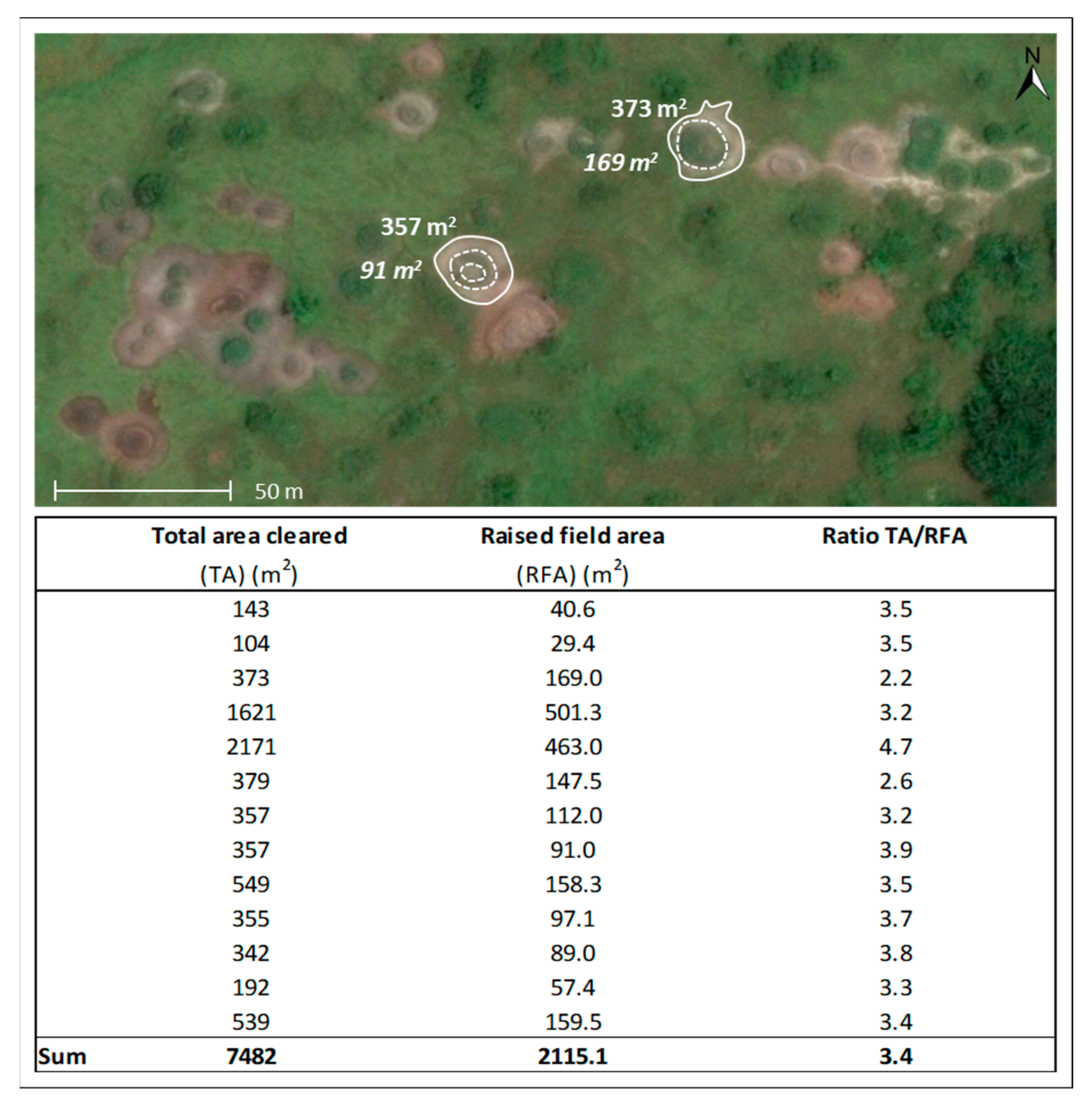
  • RF agriculture offers impressive crop yields. The incorporation of organic matter from surrounding areas during the construction of RF, and further addition after two harvests, seems to increase soil fertility. However, further soil-based studies are needed to understand to what extent the soils are enriched. The fallow-corrected gross yield of manioc we found (15.2 tons per hectare per year) is high compared to mean yields for this crop for the world and for sub-Saharan African countries (respectively 12.8 and 9.9 tons per hectare) [51,52,53]. It is also higher than the measured yields offered by flood-recessional agriculture (mitsaba) in the islands of the Congo River close to Mossaka (7.3 tons per hectare, see [50]). Our estimates of yield must, however, be considered preliminary. First, although yields were measured in 10 RF, these measures were conducted with only two farmers (in 2 and 8 RF, respectively) and only in a single year of harvest, and do not take into account variation in yield among years for the same field and among fields. Second, some inaccuracies might have occurred during the participatory weighing of the harvests. Third, we took into account yield of manioc only, whereas many other crops are planted on RF (and sometimes in the interspaces between RF). Further measures should be conducted to confirm our estimates.
RF agriculture offers major advantages in a context of wetland conservation. Wetlands provide a great range of ecosystem services (biodiversity conservation, water purification and regulation, climate regulation, nutrient cycling, etc.) but the surface they cover has dramatically decreased. It is estimated that in the last 30 years, 56 to 65% of wetlands in Europe and North America have been lost through conversion to intensive agricultural use, and 27% in Asia [3]. RF agriculture is a system that allows cultivation of wetlands without draining them, polluting them, or altering their natural flood cycle. The high yields of RF are obtained without the use of any chemical fertilizer or pesticides. By maintaining the functioning and productivity of wetlands, RF agriculture allows humans to benefit from a large spectrum of resources provided by these ecosystems, particularly aquatic resources such as fish that migrate into and reproduce in seasonal floodplains [54]. RF agriculture can thus contribute both to wetland conservation and to multiple aspects of food security.
RF agriculture offers further advantages in a context of climate change. Wetlands are ecosystems that are particularly vulnerable to climate change [3,55]. In floodplains, any changes in the timing and amount of rainfall in the river basin will affect the periodicity and amplitude of the flood pulse and in consequence the functioning of wetlands and their productivity. Owing to a lack of data, large uncertainties remain concerning the effects of climate change on precipitation and on flood frequency and intensity in tropical floodplains, particularly in the Congo Basin [56,57,58]. Yet, according to the IPCC [59], it is very likely that rainfall and flood patterns will change and that more extreme flooding and drought events might occur. Agricultural systems that are highly dependent on flood cycles—such as flood-recessional agriculture—could be strongly adversely affected by increased variability of the timing and magnitude of flood pulses and by increased probability and severity of natural hazards such as flood stage reversals [60]. By putting the crops above the highest expected water level, RF agriculture is more resilient than flood-recessional agriculture to variation in the amplitude and timing of extreme and/or unpredictable flooding.
More interest should be given to RF agriculture as a productive component of wetland subsistence systems. Although it is labor-demanding, it mitigates the risk of crop loss in a context of climate change and of increased flood-related hazards. The importance of RF in mitigating flood risk has also been pointed out for pre-Columbian RF in the lowlands of Bolivia, which were in use during past periods marked by more frequent and severe flooding [9,34]. More generally, governments and organizations should examine the role that local knowledge embodied in features of “traditional” agroecosystems can play in meeting the challenges of both food production and ecosystem preservation [61,62,63]. Yet, RF agriculture is probably not appropriate for all wetlands, and even in those where it may be, the features we observed in Mossaka cannot be globally applied. Any agricultural system must be adapted to the particularities of the local social, cultural, economic and ecological context. Studies should focus on RF agriculture as practiced today elsewhere in Africa, Asia and Oceania to better understand these systems, their local specificities, and their relevance for wetland agriculture today and in the future [25].

4.2. A Window to Explore the Functioning of Pre-Columbian Raised-Field Agriculture

In this section we explore what our results might say about how pre-Columbian RF agriculture may have functioned in somewhat similar environments, in a different time and place, and the new questions they pose for archaeologists.

4.2.1. Implications for Diversity in the Shape, Size and Spatial Organization of Pre-Columbian RF

In the Americas, given the highly diverse design of RF and the different environmental conditions in which they were built, some authors have proposed that the shape, dimensions and spatial distribution of these earthworks were determined by environmental (e.g., edaphic, hydrological or topographic) conditions [10,64,65,66]. For example, Rodrigues et al. [10] concluded that there is a strong link between each type of RF in the Llanos de Mojos and local soil properties and flooding dynamics. In French Guiana, Rostain [16] showed that elongate ridges are organized in a way that appears adaptive in relation to hydrological conditions. In areas where flooding is prolonged, these vestiges are oriented parallel to the slope to enhance drainage; while in the best-drained parts of the wetland RF were constructed perpendicular to the slope to optimize water retention. On the contrary, other authors believe that differences in RF shapes may be (at least partly) explained by arbitrary diversity of cultural practices [14,67].
In Mossaka, our informants invoked other factors in explaining diversity in RF design: the potential for conversion to a habitable plot (for round fields), for use in capturing fish (for horseshoe-shaped fields), or for demarcating fields (for elongated and crescent-moon fields). Based on their discourse, the height of the fields is adapted to the local water level, but they acknowledge no link to other environmental characteristics. However, such links cannot be ruled out. Many people also stated that farmers made RF of different shapes “for fun” and that farmers are “playing”. These statements suggest that variation in RF form might be an expression of arbitrary cultural and individual preferences. However, they might also reflect a loss of knowledge about the reasons for the diversity of shapes, accompanying the decline of this agricultural system over the past few decades. Nowadays, people who still cultivate RF build mainly circular RF (lianga) and elongated ridges (mondzeke). Only older people referred to the names molingu and ekoti (terms that had already been identified by Sautter [38]) and gave reasons for the morphological diversity of fields in relation to their functioning. The decrease in horseshoe-shaped RF (molingu) reveals the disinterest of women for this fish-trapping device following the introduction of new and more efficient fishing gears (set gillnets and hooks). Finally, as shown in Figure 2, beyond Mossaka, the general pattern and shapes of RF vary among the different regions within the cuvette centrale. Whether this variation reflects adaptations to local environments is a question that has not yet been addressed.
At Mossaka, a given structure can fulfill, either simultaneously or successively over seasons or longer time frames, diverse functions, serving as an agricultural field, a fish trap, a habitable plot, and nowadays, a proof of land tenure. Our findings in Mossaka suggest the interest, in attempts to understand pre-Columbian RF, of considering a vision of RF that goes beyond a solely agricultural function. Could a diversity of functions also have characterized pre-Columbian RF in the Americas? This cannot be ruled out. However, in contrast to Mossaka, where diverse field shapes coexist in a relatively small area, shape of pre-Columbian RF is quite constant within a given site [10], perhaps reflecting a common, solely agricultural function. Our results also show that, as has been suggested for South America [68], RF landscapes in Africa are palimpsests reflecting the history of human activities over time. Our documentation of the history of RF over the last few decades may offer ways to think about how human actions on the landscape changed over time, or simply shifted in their distribution, in pre-Columbian wetland landscapes.

4.2.2. Functioning and Management of Pre-Columbian RF in Tropical America

The most intensively debated questions about pre-Columbian RF concern the reasons for their construction and how they functioned. For some authors, RF were constructed with the primary intention of drainage, to protect crops from permanent or seasonal flooding and to mitigate the risk of crop loss during extreme flooding events [9,26,32,64,69]. Others argue that RF were not solely designed to improve drainage but that they provided further agronomic advantages. These authors claim in particular that RF would have been enriched with organic matter or other nutrient sources (e.g., vegetation and mud from the aquatic component, crop residues, and perhaps kitchen wastes, ash and charcoal) during the construction and maintenance of fields, allowing the concentration of nutrients in the cultivated area and thereby increasing soil fertility [25,27,45,70,71,72]. In line with these ideas, the construction of RF would also enhance soil structure, soil aeration and thus crop growth and field productivity [16,22,25].
Our findings support the hypothesis that construction and maintenance of RF are designed not only for a drainage function but also for nutrient management and improvement of soil structure. In Mossaka, farmers use specific grasses and associated soil to construct RF, and they periodically leave crop residues behind and add weeds to the fields to enrich their soil. In the past, when fields were close to habitation sites, kitchen waste and ash were deposited on RF [38]. Today, fields are located quite far from the city, and these domestic materials are no longer added to fields. The role of nutrient management in RF agriculture is particularly highlighted by the fact that RF are also built in parts of the floodplain that lie high enough so that rainy-season flooding does not occur: “I built my maanga in a place which is not flooded, the water stays far. I build maanga because there is grass, it’s good, it’s good for manure”. Like present-day farmers who construct RF in non-wetland soils of New Guinea [71] and in both wetland and well-drained soils in Zambia [24], farmers in Mossaka recognize the crucial importance of incorporating green manure in these infertile soils. Integrating vegetation and the stirring of soil may also improve soil structure. Unconstructed ‘natural’ soils of the floodplain are dense and compact, whereas soils of RF seem more friable and well-aerated and offer much less physical resistance to growth of tubers.

4.2.3. Productivity and Carrying Capacity of Raised-Field Agriculture

Another debated question about pre-Columbian RF is whether they could have been cultivated continuously [27,73] or whether fallow periods had to be integrated, to restore fertility [32,34] and to reduce the effect of pests and pathogens [26]. Further questions concern the relative durations of cultivation and fallow phases and how fallows were managed.
Our study shows that RF cultivation in Mossaka always incorporates fallow periods. According to local discourse, fallows mainly serve to renew soil fertility and to allow recovery of the herbaceous vegetation surrounding the fields. Pests and pathogens are apparently not considered important problems in Mossaka.
The debates relating to whether or not fallow periods were incorporated and the contribution of nutrient enrichment are elements of a broader controversy regarding the productivity of pre-Columbian RF agriculture and the size of populations it could have sustained. Regarding the yields obtained in RF rehabilitation experiments, some authors have claimed that pre-Columbian RF agriculture was highly productive [14,27,70,73]. Although this claim was made in general terms, for RF in both lowland and highland environments, most of the experimental studies that attempted to evaluate this question have been conducted in the latter. This limitation must be considered in comparisons with Mossaka, a lowland site. In experimental fields in the Lake Titicaca Basin, Erickson and Candler [27] found that yields of potato (Solanum tuberosum L.) ranged from 8 to 14 tons/ha/year, with an average of 10 tons/ha/year. This was two times larger than the national average for Peru. Kolata [73] found even more impressive potato yields with an average of 21 tons per hectare. Other authors [26,34] are skeptical and believe the benefits associated with RF (nutrient management, continuous cultivation, high productivity) are over-estimated. They argue that RF agriculture was less energetically efficient (in terms of production per unit labor, perhaps also in terms of production per unit area) than dryland agriculture.
The fallow-corrected gross yields we found in Mossaka support the hypothesis that RF agriculture can be highly productive, despite the fact that fields are not cultivated continuously. The yields of manioc we found are approximatively 1.5 times higher than mean yields for sub-Saharan Africa and are twice as high as those we measured in flood-recessional fields (mitsaba) in Mossaka. This relative yield advantage of RF agriculture is similar to that estimated for potato by Erickson and Candler [27]. However, there is at present no evidence that pre-Columbian RF were managed in a similar way as in Mossaka. We also lack information to evaluate the similarities and differences between African and South American RF sites in environmental factors such as soil properties and the availability of vegetation for green manuring.
Based on the area covered by RF, the estimated percentage of fields under cultivation and the expected yields the fields could provide, archaeologists have tried to estimate the regional carrying capacity and pre-Columbian population densities under RF agriculture. These estimations vary greatly from 1500 to 7800 pers/km2 on the shores of Lake Titicaca [73], from 50 to 100 pers/km2 in the coastal savannahs of the Guianas [16], and from 3 to 30 people per km2 in the Llanos de Mojos [28]. Projections made about pre-Columbian population size have deep implications for understanding the livelihood and social organization of these populations and the carrying capacity of Andean and lowland environments. It is interesting, and somewhat disquieting, that these projections are so variable.
Some scholars [16,73] admit that estimations of population densities that could be supported by RF agriculture are perilous and approximate, given how little we know about the cultivation cycle, the number of fields being cultivated at one time, and the broader livelihood system of the population. Our observations suggest that many estimates in the literature are likely to be wide of the mark and that neither the extent of vestiges of RF nor the productivity estimated for these fields when they were active are solid grounds for estimating population density.
In Mossaka, for example, the areal extent of RF visible in the landscape is not a good indicator of population density. A substantial proportion of RF are in fallow. As fields are cultivated over a period of 5–6 years and then left in fallow during 2–4 years, at a given time only 55% to 75% of RF are under cultivation. These estimations of proportion of RF under cultivation are lower than those that have been assumed for pre-Columbian RF (75–100%) [27,73]. Furthermore, some RF at Mossaka no longer serve as surfaces for cultivation but as (actual or potential) residential sites. Finally, in Mossaka and its environs, individual RF or even entire sites comprising many RF have fallen into complete disuse, following the death of a farmer whose heirs do not want to cultivate, or after entire villages were abandoned, leaving vestiges that cannot be distinguished, in aerial images, from fallow fields. In RF landscapes in the Americas, most RF may similarly have been inactive at any given time during the period the landscape was occupied. For all these reasons, estimates of population density based on the areal extent of vestiges of pre-Columbian RF are likely to be too high.
Moreover, estimation of population density based on agricultural production alone ignores the fact that agriculture is only part of a broader subsistence economy. Wetlands provide rich resources for hunting, fishing, and gathering. It is highly probable that, like the inhabitants of Mossaka, pre-Columbian occupants of wetlands were engaged in such activities along with agriculture. As in Mossaka, fish may have been an important component of the diet of RF farmers. Fish could be caught during their seasonal migrations into and out of floodplains [22,74]. In the Lake Titicaca Basin, Erickson [74] postulated that RF could also have been designed to help trap fish, as we noticed in Mossaka. Where permanent water was present, fish and other aquatic organisms could also have been raised in canals or ponds associated with RF [16,75,76]. However, as shown for the Llanos de Moxos, lowland RF sites in seasonal floodplains, rather than in lacustrine sites, usually lack permanent water, aside from nearby rivers [10,34].
Despite the broader recognition of fishing as part of the livelihood system of pre-Columbian RF farmers in the Americas, this activity has mostly been considered as secondary and has been overlooked. The impressive remains of RF have attracted all the attention of the researchers, who have assumed that agriculture was the major activity and that fields would provide the major source of food for people. The example of Mossaka allows another perspective. There, people have long devoted most of their time to fishing. They combine a wide set of fishing gears that allow them to fish all year long and to exploit the diversity of habitats within the floodplain [77]. Fish provide a daily supply of protein and fishing is the main source of cash for most households. The inhabitants of Mossaka consider themselves as fishermen and some even told us that “no agriculture is done at Mossaka”. Still, with the exception of constructions such as weirs [78,79], fishing activities rarely leave marks in the landscape that archaeologists could find. Fiber nets, baskets, and hooks made with porcupine quills (gears used in Mossaka before the introduction of nylon nets and iron hooks) are all perishable elements. If archaeologists came to Mossaka several centuries hence, they would discover a landscape covered by RF and would conclude that the economy was based on agriculture. Without excavations using specialized techniques, they might see little evidence that people were actually mainly engaged in fishing and trading, and that RF were built in order to complement manioc bought in from upland areas and to act as a safety net. This example is not to say that pre-Columbian inhabitants of RF landscapes were mostly fishermen. Hydrodynamics of the floodplain in Mossaka and wetlands in which pre-Columbian RF are built are different and so are fish migration and productivity. However, our observations in Mossaka do underscore the possibility that activities other than agriculture may have been crucial to the livelihoods of these people, and important in determining carrying capacity and population density of these landscapes.
The little attention given to fishing in the economy of pre-Columbian inhabitants of savannah floodplains might reflect a minor role. Alternatively, it might be explained because, with the exception of archaeological fish weirs [78,79,80], it leaves little mark on the landscape. Few studies have excavated residential sites associated with archaeological RF and searched for fish remains. This lack of attention also mirrors a relative neglect of ‘traditional’ inland fisheries throughout the tropics. Although its important economic and nutritional role is increasingly recognized, fishing still suffers from negative perceptions and knowledge gaps. Inland fishing, particularly in floodplains, is still often considered as a subsidiary activity, not very productive, and carried out as a last-resort activity and by the poorest social classes [81,82,83].
In studying the functioning of RF and in estimating carrying capacity and population densities, scholars have not only largely failed to insert agriculture in a multi-activity subsistence system (with fishing, hunting, or gathering) but have also not taken into account that societies were not isolated and may have engaged in long-distance trade relationships with other groups. Some scholars [73,74,84] have postulated that agricultural products were transported from rural areas to nearby urban centers, using networks of elevated causeways and dikes, but few have speculated that more long-distance trade could play a dominant role in economies. However, archive texts and archaeological data document the existence of dense trade networks within the entire Amazon basin [85,86,87] and beyond, reaching into the Andes [87]. Products were transported by canoe along the coast and through the dense inland hydrological network, and overland. Lathrap [85] estimated that 90% of the traded products were perishable and therefore left no archaeological trace. Agricultural products, among them processed manioc (flour and bread), and smoked and salted fish, were among important products that were exchanged [84,85].
Were pre-Columbian populations that built RF specialized in agriculture, and were they selling agricultural products? Such an inference was made by Rostain [84] concerning the Saint Agathe archaeological site in French Guiana, on the basis of the extent of RF and the presence of remains of numerous utensils for the transformation of manioc. Again, the example of Mossaka clearly shows the possibility of other interpretations. In Mossaka, the vast areas covered with RF give a somewhat distorted view of the reality of the economy, as the majority of the manioc consumed in the city comes from the outside and is bought in exchange for smoked fish.
Our analysis of the economy of present-day people who farm RF supports recommendations that studies should consider the broader range of activities that constituted the livelihood system of pre-Columbian RF farmers [23,88]. In the Americas, RF agriculture was surely not the only source of food for those who practiced it, but was part of a diversity of other activities, among which fishing and trade may have played large roles. As in Mossaka, RF may have even sometimes had primarily a storage function, to compensate for irregularities of external supply, rather than being designed to fulfill the entire food needs of communities.

4.2.4. An Agricultural System in Decline

In South America, it is estimated that from 50 to more than 90 percent of the native American population died, owing to diseases and other causes, following the European conquest [89,90,91]. In some cases, it is likely that this dramatic population decrease played a major role in the collapse of RF agriculture [25,29]. The introduction into the New World of metal tools (e.g., axes, machetes) and new plant and animal species would also have allowed the adoption of alternative agricultural systems (such as slash-and-burn agriculture) that could have accelerated the decline of RF agriculture [29,92]. However, in cases where RF were abandoned before the European conquest, other causes must be sought. Changing climates (and thus changing hydrology of floodplains) is one possible cause that has been discussed, but detailed local paleoclimatological data are lacking and dates documenting the period of use of RF and the timing of abandonment of RF and associated sites are scarce [65].
In Mossaka, the decline of RF cultivation can only be understood when we consider changes in other activities, which are in turn related to broader socio-economic and environmental changes. We postulate that people began to lose interest in RF agriculture when the storage function of RF decreased in importance in a new trade economy and when a less labor-demanding agricultural activity (flood-recessional agriculture) emerged in a changing ecological and social context (see [50] for details). Moreover, the introduction of more efficient fishing techniques led people to invest more time in fishing activities. In this new context, the advantages of RF (provision of sites for ‘live storage’ of manioc, predictable yields, mitigation of risks, and flexible calendar) were not sufficient to compensate for the labor-intensive nature of RF cultivation.
Again, we argue, in line with Bruno [88], that analyses of the decline of pre-Columbian RF agriculture would benefit from viewing this activity in the context of a more complex subsistence system and examining the interconnected roles of demographic, ecological, and socio-economic changes. Whether RF decline occurred before or after the European context, changes in other activities of the livelihood system (trade and fishing) may have diminished the relative efficiency and advantages of RF agriculture, contributing to its decline.

5. Conclusions

Our ethnoecological study in the floodplains of the cuvette centrale of the Congo Basin, among the first to examine in detail RF cultivated today, shows that the way the people construct and manage RF increases soil fertility and provides high yields, but requires much labor. We found that RF agriculture is compatible with the conservation of wetlands and that it mitigates the risks of crop loss by flooding, risks that are likely to increase in importance with the more intense and variable floods expected to occur in a context of climate change. How RF agriculture is conducted is likely to vary among sites and over time with the local biophysical and socio-economic contexts. Thus, the analogy between RF cultivation in the cuvette centrale and in pre-Columbian South America has important limitations. Still, our results offer new ways to think about controversial questions concerning pre-Columbian RF agriculture, concerning, for example, how RF were cultivated, fallow/cultivation cycles, productivity of RF and the social organization of groups that practiced RF agriculture.
One of our main conclusions is that RF agriculture is likely always only one component of a multi-activity subsistence system. Studies of pre-Columbian RF agriculture might gain from a broader vision of the great range of practices that constituted livelihood systems; among these practices fishing and trading may have played important roles. As we have illustrated, this broadening of vision could give new insights into the diversity of field shapes, the carrying capacity and population density of RF landscapes, and the dynamics and decline of RF agriculture.

Author Contributions

Conceptualization, M.C., D.M. and S.C.; Methodology, M.C.; Field Investigation, M.C.; Writing-Original Draft Preparation, M.C.; Writing, Review and Editing, M.C., S.C., L.R., D.M.; Visualization, L.R., M.C.; Funding Acquisition, D.M., M.C., L.R., S.C.

Funding

This research was funded by grants to D.M. from the Institut Universitaire de France and from the TOSCA committee (Terre, Océans, Surfaces Continentales, Atmosphère; ‘FLOODSCAPE’ project) of the French national space agency, CNES (Centre Nationale d’Etudes Spatiales); by a doctoral dissertation grant to M.C. from the French Ministère de l’Enseignement supérieur, de la Recherche et de l’Innovation; by a Post-Doc mobility grant N° P2BEP2_172250 to L.R. from the Swiss National Science Foundation; by a grant from the Groupement de Recherche ‘Mosaïque’ (GDR 3353 INEE/CNRS) to D.M., S.C. and M.C.; and by the program Soutien à la mobilité internationale-2018 of the InSHS-CNRS to S.C.

Acknowledgments

We thank the inhabitants of Mossaka for their help, support and participation. We thank Joseph Yoka and Joël Loumeto of the Faculté des Sciences et Techniques, Université Marien Ngouabi, Brazzaville, for their logistical and administrative help, and Ariane Cosiaux for help during fieldwork.

Conflicts of Interest

The authors declare no conflict of interest. The funders had no role in the design of the study; in the collection, analyses, or interpretation of data; in the writing of the manuscript, and in the decision to publish the results.

References

  1. Russi, D.; ten Brink, P.; Farmer, A.; Badura, T.; Coates, D.; Förster, J.; Kumar, R.; Davidson, N. The Economics of Ecosystems and Biodiversity (TEEB) for Water and Wetlands; IEEP: London, UK; Brussels, Belgium; Ramsar Secretariat: Gland, Switzerland, 2013; 84p. [Google Scholar]
  2. Maltby, E.; Acreman, M.C. Ecosystem services of wetlands: Pathfinder for a new paradigm. Hydrol. Sci. J. 2011, 56, 1341–1359. [Google Scholar] [CrossRef]
  3. MEA (Millennium Ecosystem Assessment). Ecosystems and Human Well-Being: Wetlands and Water Synthesis: A Report of the Millennium Ecosystem Assessment; World Resources Institute: Washington, DC, USA, 2005; 80p, ISBN 978-1-56973-597-8. [Google Scholar]
  4. Macklin, M.G.; Lewin, J. The rivers of civilization. Quat. Sci. Rev. 2015, 114, 228–244. [Google Scholar] [CrossRef]
  5. Verhoeven, J.T.A.; Setter, T.L. Agricultural use of wetlands: Opportunities and limitations. Ann. Bot. 2010, 105, 155–163. [Google Scholar] [CrossRef] [PubMed]
  6. Mollard, É.; Walter, A. Agricultures Singulières; IRD: Paris, France, 2008; 344p, ISBN 978-2-7099-1623-3. [Google Scholar]
  7. Denevan, W.; Turner, B. Forms, functions and associations of raised fields in the Old World tropics. J. Trop. Geogr. 1974, 39, 24–33. [Google Scholar]
  8. Erickson, C.L. The Dating of Raised Field Agriculture in the Lake Titicaca Basin of Peru. In Pre-Hispanic Agricultural Fields in the Andean Region; Denevan, W.M., Mathewson, K., Knapp, G., Eds.; British Archaeological Reports, International Series; BAR Publishing: Oxford, UK, 1987; pp. 373–383. [Google Scholar]
  9. Rodrigues, L.; Lombardo, U.; Fehr, S.; Preusser, F.; Veit, H. Pre-Columbian agriculture in the Bolivian Lowlands: Construction history and management of raised fields in Bermeo. Catena 2015, 132, 126–138. [Google Scholar] [CrossRef]
  10. Rodrigues, L.; Lombardo, U.; Veit, H. Design of pre-Columbian raised fields in the Llanos de Moxos, Bolivian Amazon: Differential adaptations to the local environment? J. Archaeol. Sci. Rep. 2018, 17, 366–378. [Google Scholar] [CrossRef]
  11. Whitney, B.S.; Dickau, R.; Mayle, F.E.; Walker, J.H.; Soto, J.D.; Iriarte, J. Pre-Columbian raised-field agriculture and land use in the Bolivian Amazon. Holocene 2014, 24, 231–241. [Google Scholar] [CrossRef]
  12. Darch, J.P. Drained field agriculture in tropical latin America: Parallels from past to present. J. Biogeogr. 1988, 15, 87–95. [Google Scholar] [CrossRef]
  13. Denevan, W.M. Aboriginal drained-field cultivation in the Americas: Pre-Columbian reclamation of wetlands was widespread in the savannas and highlands of Latin America. Science 1970, 169, 647–654. [Google Scholar] [CrossRef] [PubMed]
  14. Denevan, W.M. Cultivated Landscapes of Native Amazonia and the Andes; Oxford University Press: Oxford, UK, 2001; 396p, ISBN 978-0-19-925769-0. [Google Scholar]
  15. McKey, D.; Rostain, S.; Iriarte, J.; Glaser, B.; Birk, J.J.; Holst, I.; Renard, D. Pre-Columbian agricultural landscapes, ecosystem engineers, and self-organized patchiness in Amazonia. Proc. Natl. Acad. Sci. USA 2010, 107, 7823–7828. [Google Scholar] [CrossRef] [PubMed] [Green Version]
  16. Rostain, S. Le littoral des Guyanes, héritage de l’agriculture précolombienne. Etud. Rural. 2008, 1, 9–38. [Google Scholar]
  17. Dillehay, T.D.; Quivira, M.P.; Bonzani, R.; Silva, C.; Wallner, J.; Le Quesne, C. Cultivated wetlands and emerging complexity in south-central Chile and long distance effects of climate change. Antiquity 2007, 81, 949–960. [Google Scholar] [CrossRef]
  18. Martín, J.G.; Mendizábal, T.; Schreg, R.; Cooke, R.G.; Piperno, D. Pre-Columbian raised fields in Panama: First evidence. J. Archaeol. Sci. Rep. 2015, 3, 558–564. [Google Scholar] [CrossRef]
  19. Denevan, W.M. The Aboriginal Cultural Geography of the Llanos de Mojos of Bolivia; University of California Press: Berkeley/Los Angeles, CA, USA, 1966; 185p. [Google Scholar]
  20. Erickson, C.L. Archaeological Methods for the Study of Ancient Landscapes of the Llanos de Mojos in the Bolivian Amazon. In Archaeology in the Lowland American Tropics. Current Analytical Methods and Recent Applications; Stahl, P., Ed.; Cambridge University Press: Cambridge, UK, 1995; pp. 66–95. ISBN 0521444861. [Google Scholar]
  21. Janusek, J.W.; Kolata, A.L. Top-down or bottom-up: Rural settlement and raised field agriculture in the Lake Titicaca Basin, Bolivia. J. Anthropol. Archaeol. 2004, 23, 404–430. [Google Scholar] [CrossRef]
  22. Rostain, S. La Mise en Culture des Marécages Littoraux de Guyane à la Période Précolombienne Récente. In Milieux, Sociétés et Archéologues; Marliac, A., Ed.; ORSTOM: Paris, France, 1995; pp. 119–160. ISBN 2-8637-576-5. [Google Scholar]
  23. McKey, D.; Renard, D.; Zangerlé, A.; Iriarte, J.; Adame Montoya, K.; Suarez Jimenez, L.; Solibiéda, A.; Durécu, M.; Comptour, M.; Rostain, S.; et al. New Approaches to Pre-Columbian Raised-Field Agriculture: Ecology of Seasonally Flooded Savannas, and Living Raised Fields in Africa, as Windows on the Past and the Future. In Amazonia. Memorias de las Conferencias Magistrales del 3er Encuentro Internacional de Arqueología Amazónica; Rostain, S., Ed.; Ministerio Coordinador de Conocimiento y Talento Humano e IKIAM/Secretaría Nacional de Educación Superior, Ciencia, Tecnología e Innovación/Tercer Encuentro Internacional de Arqueología Amazónica: Quito, Ecuador, 2014; pp. 91–136. [Google Scholar]
  24. McKey, D.; Renard, D.; Comptour, M. Will the Real Raised-Field Agriculture Please Rise? Indigenous Knowledge and the Resolution of Competing Visions of One Way to Farm Wetlands. In Indigenous Knowledge. Enhancing Its Contribution to Natural Resources Management; Sillitoe, P., Ed.; CABI: Wallingford, UK, 2017; pp. 116–129. ISBN 9781780647050. [Google Scholar]
  25. Renard, D.; Iriarte, J.; Birk, J.J.; Rostain, S.; Glaser, B.; McKey, D. Ecological engineers ahead of their time: The functioning of pre-Columbian raised-field agriculture and its potential contributions to sustainability today. Ecol. Eng. 2012, 45, 30–44. [Google Scholar] [CrossRef]
  26. Bandy, M.S. Energetic efficiency and political expediency in Titicaca Basin raised field agriculture. J. Anthropol. Archaeol. 2005, 24, 271–296. [Google Scholar] [CrossRef]
  27. Erickson, C.L.; Candler, K. Raised Fields and Sustainable Agriculture in the Lake Titicaca Basin of Peru. In Fragile Lands of Latin America: Strategies for Sustainable Development; Browder, J., Ed.; Westview Press: Boulder, CO, USA; San Francisco, CA, USA; London, UK, 1989; pp. 230–248. [Google Scholar]
  28. Walker, J. Agricultural Change in the Bolivian Amazon; University of Pittsburgh: Pittsburgh, PA, USA, 2004; 131p, ISBN 1877812617. [Google Scholar]
  29. Walker, J.H. Raised field abandonment in the Upper Amazon. Cult. Agric. 2000, 22, 27–31. [Google Scholar] [CrossRef]
  30. Morris, A.S. Raised Field Technology: The Raised Fields Projects Around Lake Titicaca; Ashgate: Aldershot/Hants, UK; Burlington, NJ, USA, 2004; 200p, ISBN 978-0-7546-1790-7. [Google Scholar]
  31. Torres-Lima, P.; Canabal-Cristiani, B.; Burela-Rueda, G. Urban sustainable agriculture: The paradox of the chinampa system in Mexico City. Agric. Hum. Values 1994, 11, 37–46. [Google Scholar] [CrossRef]
  32. Baveye, P.C. Comment on “Ecological engineers ahead of their time: The functioning of pre-Columbian raised-field agriculture and its potential contributions to sustainability today” by Dephine Renard et al. Ecol. Eng. 2013, 52, 224–227. [Google Scholar] [CrossRef]
  33. Chapin, M. The seduction of models. Chinampa agriculture in Mexico. Grassroots Dev. 1988, 12, 8–17. [Google Scholar] [PubMed]
  34. Lombardo, U.; Canal-Beeby, E.; Fehr, S.; Veit, H. Raised fields in the Bolivian Amazonia: A prehistoric green revolution or a flood risk mitigation strategy? J. Archaeol. Sci. 2011, 38, 502–512. [Google Scholar] [CrossRef]
  35. Bai, Y.; Sun, X.; Tian, M.; Fuller, A.M. Typical water-land utilization GIAHS in low-lying areas: The Xinghua Duotian agrosystem example in China. J. Resour. Ecol. 2014, 5, 320–327. [Google Scholar] [CrossRef]
  36. Auger, A. Loboko: Exemple de terroir conquis sur l’eau. Photo-Interprétation 1967, 6, 22–28. [Google Scholar]
  37. Mumbanza mwa Bawele, J. La production alimentaire dans les marais de la Haute-Ngiri du XIXe siecle à nos jours. Afr. Econ. Hist. 1979, 7, 130–139. [Google Scholar] [CrossRef]
  38. Sautter, G. La Cuvette Congolaise: Monographie Régionale des Bassins de la Likouala-Mossaka, de l’Alima et de la Nkéni; Ministère de la coopération: Paris, France, 1962; 70p.
  39. Sautter, G. De l’Atlantique au Fleuve Congo: Une Géographie du Sous-Peuplement. République du Congo, République Gabonaise; Mouton et Cie: La Haye, The Netherlands, 1966; 1103p. [Google Scholar]
  40. Vennetier, P. Les hommes et leurs activités dans le nord du Congo-Brazzaville. Cah. ORSTOM Sér. Sci. Hum. 1965, 2, 296. [Google Scholar]
  41. Campbell, D. The Congo River Basin. In The World Largest Wetlands: Ecology and Conservation; Fraser, L.H., Keddy, P.A., Eds.; Cambridge University Press: Cambridge, UK, 2005; pp. 149–165. ISBN 9780521834049. [Google Scholar]
  42. Coynel, A.; Seyler, P.; Etcheber, H.; Meybeck, M.; Orange, D. Spatial and seasonal dynamics of total suspended sediment and organic carbon species in the Congo River. Glob. Biogeochem. Cycles 2005, 19, Art–GB4019. [Google Scholar] [CrossRef]
  43. Ndinga Mbo, A. Introduction à l’Histoire des Migrations au Congo-Brazzaville. Les Ngala dans la Cuvette Congolaise XVIIe-XIXe siècle; L’Harmattan: Paris, France, 2006; 295p, ISBN 2-296-00464-4. [Google Scholar]
  44. Maho, J. NUGL Online. The Online Version of the New Updated Guthrie List, a Referential Classification of the Bantu Languages. Available online: http://goto.glocalnet.net/mahopapers/nuglonline.pdf (accessed on 12 August 2016).
  45. Kolata, A.L.; Rivera, O.; Ramírez, J.C.; Gemio, E. Rehabilitating Raised-Field Agriculture in the Southern Lake Titicaca Basin of Bolivia: Theory, Practice, and Results. In Tiwanaku and Its Hinterland: Archaeology and Paleoecology on an Andean Civilization; Smithsonian Series in Archaeological Inquiry; Smithsonian Institution Press: Washington, DC, USA, 1996; pp. 203–230. ISBN 978-1-56098-600-3. [Google Scholar]
  46. Vennetier, P. Géographie du Congo-Brazzaville; Gauthier-Villars: Paris, France, 1966; 174p. [Google Scholar]
  47. Harms, R. Fishing and systems of production: The precolonial Nunu of the middle Zaïre. Cah. Sci. Hum. 1989, 25, 147–158. [Google Scholar]
  48. Froment, E. Trois affluents du Congo. Rivières Alima, Likouala, Sanga. Bull. Soc. Géogr. Lille 1887, 7, 458–474. [Google Scholar]
  49. Harms, R. Games Against Nature: An Eco-Cultural History of the Nunu of Equatorial Africa; Cambridge University Press: Cambridge, UK, 1999; 276p, ISBN 978-0-521-65535-4. [Google Scholar]
  50. Comptour, M. Entre Pêche, Agriculture, et Commerce, Jouer avec la Variabilité Ecologique et Sociale: Dynamique d’un Système Social-écologique dans les Plaines Inondables du Fleuve Congo. Ph.D. Thesis, University of Montpellier, Montpellier, France, 2017. [Google Scholar]
  51. FAO (Food and Agriculture Organization of the United Nations). Produire Plus avec Moins. Le Manioc. Guide pour une Intensification Durable de la Production; FAO: Rome, Italy, 2013; 128p. [Google Scholar]
  52. Fermont, A.M.; van Asten, P.J.A.; Tittonell, P.; van Wijk, M.T.; Giller, K.E. Closing the cassava yield gap: An analysis from smallholder farms in East Africa. Field Crops Res. 2009, 112, 24–36. [Google Scholar] [CrossRef]
  53. Nweke, F.I.; Lutete, D.; Dixon, A.G.; Ugwu, B.; Ajobo, O.; Kalombo, N.; Bukaka, B. Cassava Production and Processing in the Democratic Republic of Congo; COSCA: Kinshasa, Democratic Republic of Congo; Ibadan, Nigeria, 2000; 213p, ISBN 978-978-131-161-1. [Google Scholar]
  54. Junk, W.J.; Bayley, P.; Sparks, R. The flood pulse concept in river-floodplain systems. In Proceedings of the International Large River Symposium; Dodge, D.P., Ed.; Canadian Special Publication of Fisheries and Aquatic Sciences, Department of Fisheries and Oceans: Ottawa, ON, Canada, 1989; pp. 110–127. ISBN 0-660-13259-1. [Google Scholar]
  55. Aerts, J.C.J.H.; Droogers, P. (Eds.) Climate Change in Contrasting River Basins: Adaptation Strategies for Water, Food and Environment; CABI: Wallingford, UK, 2004; 288p, ISBN 978-0-85199-835-0. [Google Scholar]
  56. Alsdorf, D.; Beighley, E.; Laraque, A.; Lee, H.; Tshimanga, R.; O’Loughlin, F.; Mahé, G.; Dinga, B.; Moukandi, G.; Spencer, R.G.M. Opportunities for hydrologic research in the Congo Basin: Hydrologic research in the Congo Basin. Rev. Geophys. 2016, 54, 378–409. [Google Scholar] [CrossRef]
  57. Kundzewicz, Z.W.; Mata, L.J.; Arnell, N.W.; Döll, P.; Jimenez, B.; Miller, K.; Oki, T.; Sen, Z.; Shiklomanov, I. The implications of projected climate change for freshwater resources and their management. Hydrol. Sci. J. 2008, 53, 3–10. [Google Scholar] [CrossRef] [Green Version]
  58. Mitsch, W.J.; Nahlik, A.; Wolski, P.; Bernal, B.; Zhang, L.; Ramberg, L. Tropical wetlands: Seasonal hydrologic pulsing, carbon sequestration, and methane emissions. Wetl. Ecol. Manag. 2010, 18, 573–586. [Google Scholar] [CrossRef]
  59. Niang, I.; Ruppel, O.C.; Abdrabo, M.A.; Essel, A.; Lennard, C.; Padgham, J.; Urquhart, P. Africa. In Climate Change 2014: Impacts, Adaptation, and Vulnerability. Part B: Regional Aspects. Contribution of Working Group II to the Fifth Assessment Report of the Intergovernmental Panel on Climate Change; Barros, V.R., Field, C.B., Dokken, D.J., Mastrandrea, M.D., Mach, K.J., Bilir, T.E., Chatterjee, M., Ebi, K.L., Estrada, Y.O., Genova, R.C., et al., Eds.; Cambridge University Press: Cambridge, UK; New York, NY, USA, 2014; pp. 1199–1265. ISBN 9781107415386. [Google Scholar]
  60. List, G.; Coomes, O.T. Natural hazards and risk in rice cultivation along the upper Amazon River. Nat. Hazards 2017, 87, 165–184. [Google Scholar] [CrossRef]
  61. Sillitoe, P. (Ed.) Indigenous Knowledge. Enhancing Its Contribution to Natural Resources Management; CABI: Wallingford, UK, 2017; 272p, ISBN 978-1-78064-705-0. [Google Scholar]
  62. Altieri, M. Small Farms as a Planetary Ecological Asset: Five Key Reasons Why We Should Support the Revitalisation of Small Farms in the Global South; Third World Network: Penang, Malaysia, 2008; 24p. [Google Scholar]
  63. FAO (Food and Agriculture Organization of the United Nations). Innovation in Family Farming; FAO: Rome, Italy, 2014; 161p, ISBN 978-92-5-108536-3. [Google Scholar]
  64. Lombardo, U.; Canal-Beeby, E.; Veit, H. Eco-archaeological regions in the Bolivian Amazon: Linking pre-Columbian earthworks and environmental diversity. Geogr. Helv. 2011, 3, 173–182. [Google Scholar] [CrossRef]
  65. Rodrigues, L.; Lombardo, U.; Canal Beeby, E.; Veit, H. Linking soil properties and pre-Columbian agricultural strategies in the Bolivian lowlands: The case of raised fields in Exaltación. Quat. Int. 2017, 437, 143–155. [Google Scholar] [CrossRef]
  66. Rostain, S. Islands in the Rainforest: Landscape Management in pre-Columbian Amazonia; Routledge: Abingdon-on-Thames, UK, 2013; 277p, ISBN 978-1598746358. [Google Scholar]
  67. Erickson, C.L.; Walker, J.H. Precolumbian Causeways and Canals as Landesque Capita. In Landscapes of Movement: Trails, Paths, and Roads in Anthropological Perspective; Snead, J., Erickson, C.L., Darling, J., Eds.; University of Pennsylvania, Museum of Archaeology and Anthropology: Philadelphia, PA, USA, 2009; pp. 232–252. ISBN 9781934536131. [Google Scholar]
  68. Walker, J.H. Social implications from agricultural taskscapes in the Southwestern Amazon. Lat. Am. Antiq. 2011, 22, 275–295. [Google Scholar] [CrossRef]
  69. Lombardo, U.; Denier, S.; May, J.-H.; Rodrigues, L.; Veit, H. Human–environment interactions in pre-Columbian Amazonia: The case of the Llanos de Moxos, Bolivia. Quat. Int. 2013, 312, 109–119. [Google Scholar] [CrossRef]
  70. Erickson, C.L. Methodological Considerations in the Study of Ancient Andean Field Systems. In The Archaeology of Garden and Field; Miller, N., Gleason, K., Eds.; University of Pennsylvania Press: Philadelphia, PA, USA, 1994; pp. 111–152. [Google Scholar]
  71. Sillitoe, P. A Place Against Time: Land and Environment in the Papua New Guinea Highlands; Routledge: Abingdon-on-Thames, UK, 1996; 464p, ISBN 978-3-7186-5925-8. [Google Scholar]
  72. Wilson, C.; Simpson, I.A.; Currie, E.J. Soil management in pre-Hispanic raised field systems: Micromorphological evidence from Hacienda Zuleta, Ecuador. Geoarchaeology 2002, 17, 261–283. [Google Scholar] [CrossRef]
  73. Kolata, A.L. The technology and organization of agricultural production in the Tiwanaku State. Lat. Am. Antiq. 1991, 2, 99–125. [Google Scholar] [CrossRef]
  74. Erickson, C.L. An Archaeological Investigation of Raised Field Agriculture in the Lake Titicaca Basin of Peru. Ph.D. Thesis, Department of Anthropology, University of Illinois, Urbana-Champaign, IL, USA, 1988. [Google Scholar]
  75. Schorr, T. The structure, purpose, and social organization of Pre-Columbian ridged field systems. Presented at the 72nd Annual Meeting of the American Anthropological Association, New Orleans, LA, USA, 21 November 1972. [Google Scholar]
  76. Thompson, J.E. Canals of the Rio Candelaria Basin, Campeche, Mexico. In Mesoamerican Archaeology: New Approach; Hammond, N., Ed.; University of Texas Press: Austin, TX, USA, 1974; pp. 297–302. [Google Scholar]
  77. Comptour, M.; Caillon, S.; McKey, D. Pond fishing in the Congolese cuvette: A story of fishermen, animals, and water spirits. Rev. d’ethnoécologie 2016, 10. [Google Scholar] [CrossRef]
  78. Erickson, C.L. An artificial landscape-scale fishery in the Bolivian Amazon. Nature 2000, 408, 190–193. [Google Scholar] [CrossRef] [PubMed]
  79. McKey, D.; Durécu, M.; Pouilly, M.; Béarez, P.; Ovando, A.; Kalebe, M.; Huchzermeyer, C.F. Present-day African analogue of a pre-European Amazonian floodplain fishery shows convergence in cultural niche construction. Proc. Natl. Acad. Sci. USA 2016, 113, 14938–14943. [Google Scholar] [CrossRef] [PubMed]
  80. Blatrix, R.; Roux, B.; Béarez, P.; Prestes-Carneiro, G.; Amaya, M.; Aramayo, J.L.; Rodrigues, L.; Lombardo, U.; Iriarte, J.; de Souza, J.G.; et al. The unique functioning of a pre-Columbian Amazonian floodplain fishery. Sci. Rep. 2018, 8, 5998. [Google Scholar] [CrossRef] [PubMed] [Green Version]
  81. Béné, C.; Steel, E.; Luadia, B.K.; Gordon, A. Fish as the “bank in the water”—Evidence from chronic-poor communities in Congo. Food Policy 2009, 34, 108–118. [Google Scholar] [CrossRef]
  82. Coomes, O.T.; Takasaki, Y.; Abizaid, C.; Barham, B.L. Floodplain fisheries as natural insurance for the rural poor in tropical forest environments: Evidence from Amazonia. Fish. Manag. Ecol. 2010, 17, 513–521. [Google Scholar] [CrossRef]
  83. Dounias, E.; Cogels, S.; Mbida, S.M.; Carrière, S. The safety net role of inland fishing in the subsistence strategy of multi-active forest dwellers in southern Cameroon. Rev. d’Ethnoécologie 2016, 10. [Google Scholar] [CrossRef]
  84. Rostain, S. Spécialisation et commerce dans les Guyanes amérindiennes. Tech. Cult. 2005, 46, 139–174. [Google Scholar]
  85. Lathrap, D.W. The antiquity and importance of long-distance trade relationships in the moist tropics of Pre-Columbian South America. World Archeol. 1973, 5, 170–186. [Google Scholar] [CrossRef]
  86. Migeon, G. Le rôle de la Guyane précolombienne dans la zone d’interactions caribéo-amazonienne. EchoGéo 2008, 6, 14. [Google Scholar] [CrossRef]
  87. Prümers, H. “Charlatanocracia” en Mojos? Investigaciones arqueológicas en la Loma Salvatierra, Beni, Bolivia. Bol. Arqueol. PUCP 2009, 11, 103–116. [Google Scholar]
  88. Bruno, M.C. Beyond raised fields: Exploring farming practices and processes of agricultural change in the ancient Lake Titicaca Basin of the Andes. Am. Anthropol. 2014, 116, 130–145. [Google Scholar] [CrossRef]
  89. Denevan, W.M. (Ed.) The Native Population of the Americas in 1492, 2nd ed.; University of Wisconsin Press: Madison, WI, USA, 1992; 384p, ISBN 978-0-299-13434-1. [Google Scholar]
  90. Livi-Bacci, M. The depopulation of hispanic America after the conquest. Popul. Dev. Rev. 2006, 32, 199–232. [Google Scholar] [CrossRef]
  91. O’Fallon, B.D.; Fehren-Schmitz, L. Native Americans experienced a strong population bottleneck coincident with European contact. Proc. Natl. Acad. Sci. USA 2011, 108, 20444–20448. [Google Scholar] [CrossRef] [PubMed] [Green Version]
  92. Denevan, W.M. Stone vs metal axes: The ambiguity of shifting cultivation in prehistoric Amazonia. J. Steward Anthropol. Soc. 1992, 20, 153–165. [Google Scholar]
Figure 1. Map showing distribution of vestiges of pre-Columbian raised fields (RF) in South America and Central America, adapted from Denevan [13] and adding cases discovered since 1970 in Chile [17] and Panama [18]. Different kinds of raised fields are illustrated in Google Earth images and by line drawings. DEM (Digital Elevation Model) data for Central and South America: CGIAR-CSI SRTM90m Database.
Sustainability 10 03120 g001
Figure 2. Diversity of raised fields (RF) in the cuvette centrale of the Congo Basin. Digital Elevation Model of the study area, indicating sites with RF (red dots), DEM data: CGIAR-CSI SRTM90m Database. Google Earth image: ©2018 Digital Globe, 03.08.2015, 17.05.2009, 06.03.2017, 26.05.2005; ©2018 CNES/Airbus, 19 May 2016.
Sustainability 10 03120 g002
Figure 3. Diversity of RF shapes in Mossaka. (A) Circular RF named lianga; (B) Crown- or horseshoe-shaped RF called molingu; (C) Elongated RF named mosambuku or ekoti; (D) RF in the form of a crescent moon called mombaka. All photos © M. Comptour; Google Earth image © 2018 CNES/Airbus, 02.02.2014, 19 May 2016, used with permission.
Sustainability 10 03120 g003
Figure 4. Construction of RF in the floodplain around Mossaka. (A) Grass and soil clumps are hoed from the area surrounding the new field; (B,C) Root-bound soil clumps are oriented outward, the grass tops are oriented inward; (D) Vegetation-free topsoil is added to cover the field; (E,F) The new field is soon planted with manioc, the major crop. All photos © M. Comptour.
Sustainability 10 03120 g004
Figure 5. Cultivation/fallow cycle of RF.
Sustainability 10 03120 g005
Figure 6. Area required to be cleared to provide green manure for the building and maintenance of RF, including the RF itself (dotted white lines) and surrounding grassland (solid white lines). Area of the RF in m2 is given by the figures in italics, area of the total cleared surface (RF plus surrounding grassland) by the figures in normal typeface. Google Earth image (1°12′44.95″ S 16°46′39.68″ E), Image © 2018 Digital Globe, 23 May 2015.
Sustainability 10 03120 g006
Table 1. Assessment of yields of RF in Mossaka.
MeasuresAbbreviationMethod
Total weight of the harvest in 2014 (kg)WhParticipatory weighing with 2 farmers
Raised field area (m2)RFaMeasures of the area of the harvested fields using a measuring tape
Net yield (kg/m2)NY Sustainability 10 03120 i001
Proportion of floodplain area occupied by raised fieldsPfAssessment from 4 plots of 1 ha through Google Earth satellite images
Gross yield (kg/m2)GY Sustainability 10 03120 i002
Probability that a given field will be harvested in a given yearPhEstimated from the fallow/cultivation calendar of 8 farmers
Fallow-corrected gross yield (kg/m2)CGY Sustainability 10 03120 i003
Table 2. Estimated yields of RF agriculture in Mossaka.
MeasuresAbbreviationFarmer 1Farmer 2Mean
Total weight of the harvest in 2014 (kg)Wh13601185
Raised field area (m2)RFa130.6
(from eight raised fields: three lianga and 5 mondzeke)
74.5
(from two raised fields: two lianga)
Net yield (kg/m2)NY10.415.913.2
Proportion of floodplain area occupied by raised fields Pf0.28
Gross yield (kg/m2)GY2.94.53.7
Probability that a given field will be harvested in a given yearPh0.41
Fallow-corrected gross yield (kg/m2)CGY1.21.81.52

