
Basalt and Encrusted Saxifrage (Saxifraga paniculata): Strained Relationships, Pukaskwa National Park, Canada
In this note, I speculate that the geological history seen along one segment of the Southern Headland trail, Pukaskwa National Park, Ontario, Canada (Photo 1), had an important influence on the distribution and abundance of calcicolous, Arctic disjunct encrusted saxifrage (Saxifraga paniculata) plants (Photo 2).

Photo 1: Location of Pukaskwa National Park, Ontario, Canada. The park is located on the north shore of Lake Superior. The cold water body of Lake Superior helps create a local micro-climate that supports Arctic disjunct plants. Image base from Google Earth.

Photo 2: The calcicolous encrusted saxifrage (Saxifraga paniculata) is one of the Arctic disjunct plant species that grows along the Lake Superior coast. This species was growing on smooth-surfaced, diabase dike headland between the Pic River and the north end of north beach, Pukaskwa National Park, Ontario, Canada. Photo by Andy Fyon, June 7, 2022.
There are two important factors that I highlight:
proximity to Lake Superior; and
availability of the mineral calcite.
Specifically, the highest abundance of S. paniculata along the Southern Headland trail appears to be associated with highly strained, pillow basalt and that part of the rock history made calcium in the rock available to the calcicolous plant S. paniculata. To simplify a bit, I will refer to highly strained rock as highly deformed rock. That highly deformed rock was the result of great geological forces, heat, and pressure that profoundly changed the original rock. The deformation released calcium that was tightly bound in original rock-forming silicate minerals. The liberated calcium created a local calcareous habitat that supports encrusted saxifrage (Saxifraga paniculata).
Disclaimer
I see the world through the eyes of a geologist. Therefore, I am biased in what I see, how I think, and how I relate what I see to other features, including plants. Also, I speculate in this note, but those speculations are founded on observations.
Arctic Disjunct Plants in the Great Lakes Basin
Saxifraga paniculata and other Arctic disjunct plant species occur along the Lake Superior coast and elsewhere in the Great Lakes basin. These disjunct plants normally grow in the Arctic, 100s of kilometres away. The presence of Arctic disjunct plants in the Great Lakes basin has been recognized for some time:
James H. Soper, Claude E. Garton, and David R. Given (1989): Flora of the North Shore of Lake Superior (Vascular Plants of the Ontario Portion of the Lake Superior Drainage Basin), Syllogeus series No. 63 , National Museums of Canada, National Museum of Natural Sciences.
Bakowsky, W. D. (1998): Rare communities of Ontario: Great Lakes arctic-alpine basic bedrock shoreline. Natural Heritage Information Centre Newsletter 4(2): 10–11.
W.D. Bakowsky (1998): Significant Flora and Vegetation along the North Shore of Lake Superior, internal report, Natural Heritage Information Centre, then Ontario Ministry of Natural Resources.
Volcanic Bedrock Lakeshore, Michigan Natural Features Inventory, Michigan State University;
Samuel Brinker (2017): Discovery of Chamaenerion latifolium (L.) Holub (Onagraceae) in the Great Lakes Region, The Great Lakes Botanist 56(1-2):3-9; and
Chel Anderson (2019): Living Relicts – The North Shore’s Intriguing Disjunct Flora. Quetico Superior Wilderness News, March 29, 2019.
Why Do Arctic Plants Grow Along The Lake Superior Coast?
Why do Saxifraga paniculata and other Arctic disjunct plants occur along parts of the Lake Superior coast? Proximity to the massive, cold, Lake Superior water body is one important factor because the cold water creates a micro-climate resembling the Arctic: cool, short growing season, harsh foggy conditions (Photo 3), desiccating winter winds, ice storms, and ice scour during winter storms.

Photo 3: Coastal fog along the Lake Superior coast, seen from the Manitou miikana trail, is one factor that helps create an habitat suitable for the Arctic disjunct plants. Pukaskwa National Park, Ontario, Canada. Photo by Andy Fyon, June 9, 2022.
These conditions support Arctic disjunct plants along the coast of Lake Superior and other of the Great Lakes. But are there other factors? In this note, I speculate that geology also plays an important role. Let’s explore this thought.
Saxifraga paniculata Along the Southern Headlands Trail, Pukaskwa National Park
The Southern Headland trail, Pukaskwa National Park, is known for its abundance of the calcicolous encrusted saxifrage (Saxifraga paniculata) (Photo 4). Other headlands occur in the area, north to the Pic River (Photo 5). Based on my informal, anecdotal observation, Saxifraga paniculata is present on those northern headlands and rock outcrops, but the plants are not nearly as abundant as on the Southern Headlands area. That suggests other factors, in addition to proximity to Lake Superior, must influence the location and abundance of S. paniculata.

Photo 4: The calcicolous, encrusted saxifrage (Saxifraga paniculata) is very abundant growing on deformed pillow basalt in the area enclosed by the red ellipse. Conversely, very few encrusted saxifrage plants occur along the northwest edge of the Southern Headland, which is underlain by well preserved pillow basalt. The abundance of S. paniculata along this segment of the Southern Headland trail, on this part of the headland, appears to reflect the presence of highly deformed basalt substrate. Image base from Google Earth, August 9, 2022.

Photo 5: Other headlands and rocky outcrops occur along the Lake Superior coast between the Pic River and the Southern Headland. Qualitatively, my assessment is that encrusted saxifrage (Saxifraga paniculata) is not abundant, and in some cases is absent, on the rocky areas marked by brown stars. The area of abundant Saxifraga paniculata on the southern edge of the Southern Headland trail is marked by the red star and the red ellipse. Google Earth image base.
Calcicolous Plants and Accessible Calcium
Saxifraga paniculata is a calcicolous plant. It thrives on calcium-rich (lime-rich) substrates. Limestone, which contains about 40% calcium, and dolostone (Photo 6), which can look a lot like limestone, are common calcium-bearing, calcareous, sedimentary rocks. Basalt (Photo 7), gabbro (Photo 8), and diabase (Photo 9) are three less familiar igneous rock types that contain about 10% calcium. Note, more than 90% of all volcanic rock on Earth is basalt, which forms most ocean floors. Gabbro and diabase are intrusive rocks having a composition similar to basalt, but they solidified before it reached the Earth’s surface.
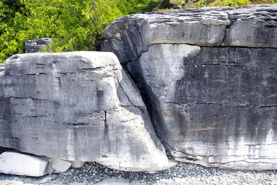
Photo 6: Amabel formation dolostone is a common calcareous rock found in southern Ontario. Photo: Andy Fyon, Mississagi Lighthouse, Manitoulin Island, Ontario, July 11, 2015.

Photo 7: Well preserved, bun shaped pillow features occur in an ancient basalt lava that is exposed along the northwest edge of the Southern Headland, adjacent to Horseshoe Bay, Pukaskwa National Park. The remarkably well preserved pillow features are important clues telling the geologist that this rock has not been highly deformed. Photo: Andy Fyon, June 7, 2022.

Photo 8: A well preserved gabbro or coarse grained basalt igneous rock exposed at the tip of Manitou miikana trail, Pukaskwa National Park. It is difficult to distinguish between gabbro, which is an intrusive igneous rock, and coarse-grained basalt, which is an igneous volcanic rock, where cross-cutting relationships, also known as intrusive relationships, are not visible. This rock is not highly deformed and supports only a few encrusted saxifrage plants. Photo: Andy Fyon, June 9, 2022.

Photo 9: Diabase dike, an igneous rock, exposed along the Southern Headland trail, Pukaskwa National Park. Photo: Andy Fyon, June 7, 2022.
Having a calcium-bearing rock substrate is important to support a calcicolous plant, but having calcium in the rock is only part of the story. That calcium in the rock must be accessible to the plant. For example, calcium in limestone occurs in the mineral calcite. Calcite reacts easily with snow melt and rain water and near-surface groundwater, which can dissolve the limestone rock, creating caves and other karst features. That dissolution process is a form of hydrolysis weathering, which causes the transfer of calcium from rock-forming minerals into a water solution. Once in a water solution, the liberated calcium is available to create a calcareous habitat where the calcium is accessible by calcicolous plants.
Conversely, in unweathered basalt, gabbro, and diabase rocks, calcium is tightly bound in anhydrous, silicate minerals, such as plagioclase and pyroxene. These silicate minerals do not react quickly with the atmosphere or surface and near-surface water. To release the calcium from these rock-forming silicate minerals, the rock must be subjected to special geological processes, like metamorphism or hydrolysis weathering. Those hydrating geological processes transform the tough, anhydrous, silicate minerals into secondary minerals. Those secondary minerals more easily release calcium to the environment, where the calcium is available to plants.
I provide more details and examples of hydrolysis, chemical weathering and the liberation of calcium from rock-forming minerals in a discussion entitled “Ingredients Of A Calcareous Habitat - A Geologist’s Perspective”.
To support calcicolous plants, the habitat and plant substrate must not only contain calcium, but that calcium must be in a form that is readily available to the plant.
Geology of the Southern Headland Trail
Anecdotally, there is something different about the geological history of the bedrock along that part of the Southern Headland trail where Saxifraga paniculata is so abundant. Basalt is the dominant rock type where the Southern Headland trail traverses the headland. On one northern side of the headland, well preserved features called pillows (Photo 7) are preserved in the basalt. The bun-shaped pillow features have not been strongly deformed and are easily recognizable (Photo 10).

Photo 10: Close view of bun-shaped pillow features preserved in pillow basalt, exposed along the northwest edge of the Southern Headland. These pillow basalt lavas are remarkably well preserved for a rock that is about 2750 million years ago. Photo: Andy Fyon, Pukaskwa National Park, June 7, 2022.
The pillow structures formed 2750 million years ago when the basalt lava erupted onto an ancient ocean floor. I did not see any calcium-rich lime scale on those well preserved pillow features and very few Saxifraga paniculata plants occur on the pillow basalt lava.
Conversely, basalt lava along the south edge of the Southern Headland trail is highly deformed (Photo 11, 12).

Photo 11: Highly deformed pillow basalt exposed along the southeast edge of the Southern Headland trail. The wavy lines seen on the surface are created by thin layers of deformed basalt. They resemble pages of a book standing vertically on the rock surface. Photo: Andy Fyon, June 10, 2022.

Photo 12: Along the Southern Headland trail, a zone of highly deformed pillow basalt lies between the two red arrows. The intense deformation transformed the pillow basalt into thin layers of rock that resemble pages of a book. This outcrop occurs in the area of the information sign describing Arctic disjunct plants. Many plants of encrusted saxifrage (Saxifraga paniculata) grow in the shallow crevices created by the near vertical layers of highly deformed pillow basalt. Photo: Andy Fyon, June 10, 2022.
Pillow features in the highly deformed pillow basalt are hard to recognize because the rock has been transformed into many paper-thin, near-vertical layers, which resemble pages in a book that stand vertically on edge (Photo 13).

Photo 13: Highly deformed pillow basalt exposed along the southeast edge of the Southern Headland trail. Encrusted saxifrage (Saxifraga paniculata) plants are abundant growing on this highly deformed basalt. The deformation transformed the basalt into thin, near vertical layers that resemble pages in a book. The geological process that deformed the basalt helped to liberate the calcium from the rock. That liberated calcium is more available to calcicolous plants like Saxifraga paniculata. Photo: Andy Fyon, June 10. 2022.
In places, the surfaces of some of the highly deformed basalt are coated with what appears to be white-coloured lime scale (Photo 14).

Photo 14: In places, the surfaces of the highly deformed basalt are coated a white-coloured scale that resembles calcite-rich precipitate called lime scale, as illustrated by the white-coloured deposits shown in this photo. That calcareous material presumably formed when calcite-saturated groundwater reacted with the atmosphere, degassed its CO2 gas, and calcite precipitated. More work is required to validate the presence of lime scale, which I saw only on the highly deformed pillow basalt, Southern Headland trail, Pukaskwa National Park. Photo: Andy Fyon, June 7, 2022.
This area of highly deformed pillow basalt is the location of many plants of encrusted saxifrage (Saxifraga paniculata). The plants grow in the shallow crevices created by the near vertical layers of highly deformed pillow basalt (Photo 15).

Photo 15: Many plants of encrusted saxifrage (Saxifraga paniculata) grow in the shallow crevices created by weathering and erosion of the weaker, near vertical layers, of highly deformed pillow basalt, Southern Headland trail, Pukaskwa National Park. Google Earth Photo: Andy Fyon, June 10, 2022.
Northern Headlands
Following the Lake Superior coast north to the Pic River, Saxifraga paniculata is locally present on rocky coastal outcrops and headlands, but is not very common (Photo 5). Geologically, those northern headland rocks with few Saxifraga paniculata are composed of: a) little deformed basalt that does not easily release its calcium; b) other types of volcanic and sedimentary rock that do not contain much calcium; and c) a diabase dike which is pristine and has its calcium still bound tightly in silicate minerals. It appears that those northern rocks do not contain much accessible calcium needed to support the calcicolous Saxifraga paniculata.
So, it appears that the different rock substrates and their different geological histories, play a role in discouraging the growth of Saxifraga paniculata plants on the headlands between the Pic River and the Southern Headland trail.
Summary: Location and Abundance of Encrusted Saxifrage (Saxifraga paniculata)
The following observations help tell a story about the location and abundance of the calcicolous encrusted saxifrage (Saxifraga paniculata) along one segment of the Southern Headland trail and elsewhere along the Lake Superior coast from the Southern Headland trail to the Pic River:
Saxifraga paniculata is abundant along a segment of the Southern Headland trail where basalt is highly deformed and rendered to thin layers of rock; that deformation transformed the basalt into minerals that easily give up their calcium;
locally in the area of highly deformed basalt, white-coloured calcite precipitate coats basalt surfaces;
Saxifraga paniculata does occur on the northern headlands up to the Pic River, but plants are much less abundant compared to the Southern Headland trail segment where the highly deformed basalt occurs. In fact, Saxifraga paniculata appears to be absent from some of those other rocky outcrops that jut out into Lake Superior. Those headlands are composed of rock types that are not highly deformed, or where deformed, the rocks do not contain much calcium.
Encrusted saxifrage (Saxifraga paniculata) occurs in abundance along one segment of the Southern Headland trail because highly deformed basalt - a rock with 10% calcium - is the substrate adjacent to Lake Superior. The proximity to large, cold water body of Lake Superior creates an Arctic-like microclimate. But the proximity to Lakes Superior and the presence of basalt is not enough. The ideal conditions needed to support the calcicolous encrusted saxifrage (Saxifraga paniculata) in abundance were established where the basalt was highly deformed. That deformation took place millions of years ago, but that geological process transformed the basalt into a state where its calcium, held within the secondary rock-forming minerals, was more easily liberated by reaction with modern-day surface water.
Speculations And Cautions
I have speculated that the abundance of the Arctic disjunct, calcicolous, encrusted saxifrage (Saxifraga paniculata) along one segment of the Southern Headland trail, Pukaskwa National Park, is the result of geological processes that: a) created basalt; b) deformed and transformed the basalt such that its calcium is now accessible by reaction with surface water and groundwater; c) caused the local precipitation of calcium scale; and d) created a calcareous microhabitat that supports the encrusted saxifrage (Saxifraga paniculata). Proximity to the large, cold water body of Lake Superior is also critical.
There are many uncertainties. I have not rigorously counted, or quantified, the number of encrusted saxifrage (Saxifraga paniculata) plants in the area. Plant abundance is a subjective guess. I have not walked the entire Lake Superior coast in Pukaskwa National Park. I did not quantitatively measure the concentration of calcium in all the rocks present. I did not chemically determine what the white-coloured scale is calcite. I did not measure the temperature of the water in the bay fed by the Pic River; warmer temperatures may account for the fewer Saxifraga paniculata plants on the northern rocky headlands and outcrops in the northern area. Despite the many uncertainties, the observations lead to formulation of a working scientific hypothesis, which you can help test.
Testing An Hypothesis: Let’s Be A Geo-botanist
You can consider my speculation as a “working hypothesis” and you can help test this hypothesis.
Next time you walk along the Lake Superior coast, perhaps you will come across encrusted saxifrage (Saxifraga paniculata)(Photo 16).
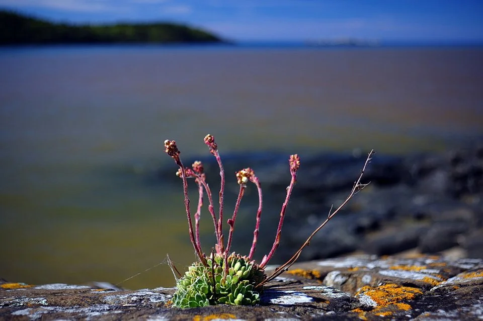
Photo 16: Calcicolous, Arctic disjunct encrusted Saxifrage (Saxifraga paniculata), just coming into flower. This plant is growing a an outcrop of diabase dike, at the north end of North Beach, close to the Pic River. The plant is one of few I saw north of the Southern Headland trail, Pukaskwa National Park. Photo: Andy Fyon, June 7, 2022.
Try to answer these questions:
do you see Saxifraga paniculata?;
is Saxifraga paniculata really abundant, meaning do you have to watch each step to avoid stepping on a plant or do you see just a few plants here and there?;
what type of rock is the Saxifraga paniculata growing on?;
is the rock highly deformed, meaning, does it consist of near many near-vertical, thin layers, like pages of book, is the rock lumpy, or does the rock have a smooth, uniform surface?;
on the rock, where exactly does the plant occur; are there many irregular crevices that control where the plant grows?; and
do you see any white-coloured coatings on the rocks in the areas where Saxifraga paniculata grows abundantly?
These questions are not easily answered. We many not agree on the answers, partly because the answers are subjective. But, making these types of observations adds a bit of additional excitement and geological purpose to your walk. Good luck and let me know how it goes.
Acknowledgement:
I extend a huge thanks to Amy Whitehorne Mackie, Visitor Experience Manager, Pukaskwa National Park, for her help during my visit in June 2022. Following several years of encouragement from Amy, I finally got to Pukaskwa National Park after a 35 year absence. Amy kept reminding me that encrusted saxifrage was quite common in Pukaskwa National Park. She is correct! Early June was a busy time for Amy, yet she went out of her way to talk with me, suggest areas to look at, and provided resource material. Thank you Amy. I am very appreciative.
Andy Fyon: August 12, 2022