
A Moderate Risk (Level 3 of 4) Excessive Rainfall Outlook and Flood Watches have been issued for portions of east Texas into Louisiana Thursday where flash, urban, and riverine flooding is possible. A Slight Risk (Level 2 of 5) for scattered severe thunderstorms has been issued from west Texas to the lower Mississippi Valley Thursday afternoon into Thursday night. Read More >
Overview
On the evening of July 9th, intense thunderstorms developed rapidly along a warm front draped from northwest to southeast across the area. There were two rounds of thunderstorms, the first being discrete, rotating storms called supercells. These supercell thunderstorms dropped large hail across portions of western Illinois (Mt. Sterling area) and also across the western St. Louis metro area. Hail in excess of 2 inches was noted in both of these supercells.
Over time, the storms congealed into a large complex of thunderstorms known as a mesoscale convective complex (MCS). This line of storms contained damaging, sometimes destructive winds as they quickly pushed southeast across east-central Missouri into southwest Illinois. The worst damage was noted from Rensselaer, MO southward to Perry, MO, where straight-line winds of 90 mph were found. This same line of storms also affected the St. Louis metro area, bringing widespread 60-70 mph winds across the metro causing many large tree limbs to fall and many to be without power.
 |
 |
 |
 |
|
3-D radar loop of storm dropping hail over St. Louis County
|
Strong winds passing through Perry, MO |
Line of storms that caused damage in northeastern MO |
Windstorm that impacted the St. Louis metro area |
Wind & Hail:
Wind
Here are some of the damage pictures we received from the event. The worst winds and most widespread damage were noted in the town of Perry, MO, where 80-90 mph were determined to have occurred via an NWS storm survey.
 |
 |
 |
 |
|
Fence blown down in Rensselaer, MO
|
Damage in Downtown St. Louis Image courtesy of @GroovyColleen |
Tree Uprooted in Perry, MO
|
Damage in Perry, MO Image courtesy of WGEM |
 |
 |
 |
 |
|
Tree Uprooted in Downtown St. Louis Image courtesy of @GroovyColleen |
Tree Snapped in Perry, MO
|
Damage in Perry, MO Image courtesy of WGEM |
Limbs broken in Rensselaer, MO
|
Hail
Here are some pictures of the large hail that fell across the western St. Louis metro area. Additional hail of this size was reported in the Mt. Sterling, IL area.
 |
 |
 |
 |
|
1.50" Hail in Bridgeton, MO Image courtesy of Evan Travis |
Hail in Creve Coeur, MO Image courtesy of Kim K. |
Hail in Overland, MO Image courtesy of @mvemjsunp |
Hail in Kirkwood, MO Image courtesy of @ite_mumma |
Here is the list of all the storm reports received from that evening. The blue icons are wind damage reports, with the green icons being hail reports.
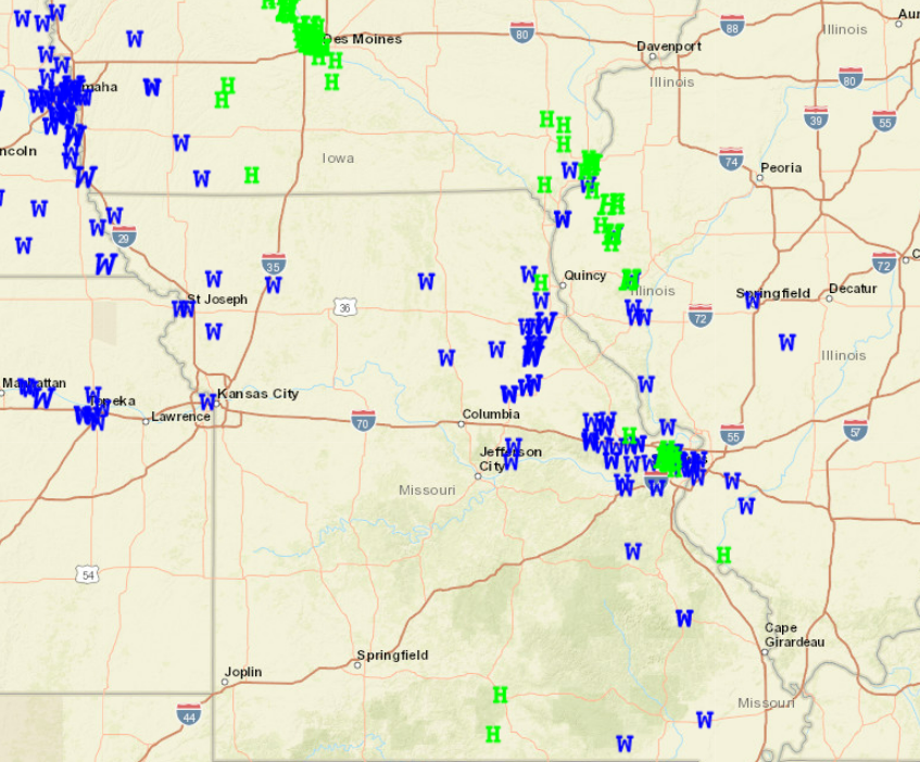
PRELIMINARY LOCAL STORM REPORT...SUMMARY NATIONAL WEATHER SERVICE ST LOUIS MO 456 PM CDT SAT JUL 10 2021 ..TIME... ...EVENT... ...CITY LOCATION... ...LAT.LON... ..DATE... ....MAG.... ..COUNTY LOCATION..ST.. ...SOURCE.... ..REMARKS.. 0130 AM TSTM WND GST 1 NE OLD MINES 38.03N 90.75W 07/10/2021 E60 MPH WASHINGTON MO PUBLIC LARGE TREE BRANCHES BLOWN DOWN. 1142 PM TSTM WND DMG WARRENTON 38.82N 91.14W 07/09/2021 WARREN MO TRAINED SPOTTER DELAYED REPORT: LARGE SIGN DAMAGED NEAR THE SHOPPING CENTER OFF WARREN COUNTY CTR. SEVERAL TREES DOWN IN THE AREA, ONE OF WHICH IS 3 FEET IN DIAMETER AND UPROOTED. TIME ESTIMATED BY RADAR. 1142 PM TSTM WND DMG 3 NNE WARRENTON 38.86N 91.13W 07/09/2021 WARREN MO TRAINED SPOTTER DELAYED REPORT: SPOTTER CALLED TO REPORT DAMAGE TO SEVERAL MANUFACTURED HOMES NEAR OFF CRANBERRY COURT. UNDERPINNING HAS BEEN BLOWN OFF WITH A COUPLE OF HOMES SUFFERING DAMAGE TO TIE DOWNS/SUPPORTS. TIME ESTIMATED BY RADAR. 1145 PM TSTM WND GST WARRENTON 38.83N 91.14W 07/09/2021 E60 MPH WARREN MO PUBLIC STORM SPOTTER REPORTS 60 MPH WINDS AND POWER FLASHES. 1152 PM TSTM WND DMG 2 SSW WRIGHT CITY 38.80N 91.04W 07/09/2021 WARREN MO TRAINED SPOTTER TREE TOPPED. SMALL SHED MOVED SEVERAL FEET. 0914 PM HAIL BRIDGETON 38.77N 90.43W 07/09/2021 E0.25 INCH ST. LOUIS MO TRAINED SPOTTER 0918 PM HAIL 1 SSW BRIDGETON 38.75N 90.44W 07/09/2021 M1.25 INCH ST. LOUIS MO TRAINED SPOTTER REPORT NEAR I-70 AND I-270 INTERCHANGE. 0920 PM HAIL BRIDGETON 38.77N 90.43W 07/09/2021 M1.00 INCH ST. LOUIS MO TRAINED SPOTTER 0921 PM HAIL SAINT ANN 38.73N 90.39W 07/09/2021 M1.00 INCH ST. LOUIS MO TRAINED SPOTTER 0921 PM HAIL OVERLAND 38.70N 90.37W 07/09/2021 M1.00 INCH ST. LOUIS MO TRAINED SPOTTER 0922 PM HAIL 2 ESE MARYLAND HEIGHTS 38.71N 90.45W 07/09/2021 M2.00 INCH ST. LOUIS MO PUBLIC FACEBOOK PICTURE OF 2 INCH HAIL. 0923 PM HAIL 2 S BRIDGETON 38.74N 90.43W 07/09/2021 M1.75 INCH ST. LOUIS MO TRAINED SPOTTER REPORTED NEAR PARKWOOD AND ST. CHARLES ROCK ROAD. 0923 PM HAIL 2 E MARYLAND HEIGHTS 38.73N 90.44W 07/09/2021 M0.88 INCH ST. LOUIS MO PUBLIC 0927 PM TSTM WND GST 2 E MARYLAND HEIGHTS 38.72N 90.44W 07/09/2021 E60 MPH ST. LOUIS MO AMATEUR RADIO HAM OPERATOR RELAYED A REPORT OF 60 MPH WIND (ESTIMATED) NEAR DORSETT AND 270. 0931 PM HAIL 2 NNE CREVE COEUR 38.69N 90.42W 07/09/2021 U1.25 INCH ST. LOUIS MO PUBLIC REPORT FROM MPING: HALF DOLLAR (1.25 IN.). 0932 PM HAIL 1 NNW CREVE COEUR 38.67N 90.44W 07/09/2021 U1.50 INCH ST. LOUIS MO PUBLIC REPORT FROM MPING: PING PONG BALL (1.50 IN.). 0932 PM HAIL 2 N CREVE COEUR 38.68N 90.43W 07/09/2021 M2.00 INCH ST. LOUIS MO TRAINED SPOTTER REPORT TAKEN BETWEEN SCHULTE ROAD AND CRAIG ROAD. 0932 PM HAIL 1 N CREVE COEUR 38.68N 90.43W 07/09/2021 U1.75 INCH ST. LOUIS MO PUBLIC REPORT FROM MPING: GOLF BALL (1.75 IN.). 0934 PM HAIL BRENTWOOD 38.61N 90.35W 07/09/2021 M0.70 INCH ST. LOUIS MO PUBLIC PUBLIC REPORT FROM MADGE AVENUE. 0940 PM HAIL WARSON WOODS 38.61N 90.39W 07/09/2021 E0.25 INCH ST. LOUIS MO PUBLIC 0941 PM HAIL BRENTWOOD 38.62N 90.35W 07/09/2021 M0.25 INCH ST. LOUIS MO TRAINED SPOTTER PEA SIZE HAIL MIXING WITH VERY HEAVY RAIN. 0942 PM HAIL 1 ENE CREVE COEUR 38.67N 90.42W 07/09/2021 E1.00 INCH ST. LOUIS MO TRAINED SPOTTER 0942 PM HAIL BRENTWOOD 38.62N 90.35W 07/09/2021 M0.70 INCH ST. LOUIS MO TRAINED SPOTTER 0945 PM HAIL CREVE COEUR 38.66N 90.43W 07/09/2021 M1.75 INCH ST. LOUIS MO AMATEUR RADIO AT MOSLEY AND LADUE. 0947 PM HAIL 1 NW BRENTWOOD 38.63N 90.36W 07/09/2021 E1.00 INCH ST. LOUIS MO PUBLIC 1230 AM TSTM WND DMG 2 WSW SAINT ANN 38.71N 90.42W 07/10/2021 ST. LOUIS MO AMATEUR RADIO LARGE TREE DOWN ON DORSETT WEST OF LINDBERGH. 1230 AM TSTM WND DMG 2 NW CHESTERFIELD 38.67N 90.60W 07/10/2021 ST. LOUIS MO BROADCAST MEDIA STEEL HIGHWAY SIGN BLOWN OVER AT I-64 AND BOONES CROSSING. 1235 AM TSTM WND DMG 2 NNW SAINT ANN 38.75N 90.40W 07/10/2021 ST. LOUIS MO FIRE DEPT/RESCUE POWER LINES DOWN. 1235 AM TSTM WND DMG SAINT ANN 38.73N 90.38W 07/10/2021 ST. LOUIS MO AMATEUR RADIO LARGE TREES DOWN ALONG BALTIMORE AVENUE AND RONALD DRIVE IN ST. ANN. 1240 AM TSTM WND DMG 1 SSE SAINT JOHN 38.70N 90.34W 07/10/2021 ST. LOUIS MO PUBLIC LARGE TREE BRANCHES BLOWN DOWN, 2-4 INCHES IN DIAMETER. 1242 AM TSTM WND GST 2 NNW WOODSON TERRACE 38.75N 90.37W 07/10/2021 M70 MPH ST. LOUIS MO ASOS ST. LOUIS LAMBERT INTERNATIONAL AIRPORT. 1244 AM TSTM WND DMG 1 W GREENDALE 38.69N 90.33W 07/10/2021 ST. LOUIS MO PUBLIC NUMEROUS LARGE TREE LIMBS BLOWN DOWN AROUND THE INTERSECTION OF FLORA AVENUE AND MIDLAND BLVD. 0211 AM FLOOD 1 NNE SAINT ANN 38.74N 90.38W 07/10/2021 ST. LOUIS MO TRAINED SPOTTER 4300 BLOCK OF ASHBY STREET, WATER HAS RISEN OUT OF THE BANKS OF COLDWATER CREEK. 1238 AM TSTM WND DMG 1 E RICHMOND HEIGHTS 38.63N 90.31W 07/10/2021 ST. LOUIS CITY MO NWS EMPLOYEE DELAYED REPORT: SEVERAL TREE LIMBS DOWN IN RICHMOND HEIGHTS NEAR MCCAUSLAND AND NASHVILLE AVE RANGING FROM 3 TO 5 INCHES IN DIAMETER. TIME ESTIMATED BY RADAR. 1251 AM TSTM WND GST 3 NNE SAINT LOUIS 38.68N 90.22W 07/10/2021 E60 MPH ST. LOUIS CITY MO AMATEUR RADIO 1252 AM TSTM WND DMG 2 E SAINT LOUIS 38.63N 90.20W 07/10/2021 ST. LOUIS CITY MO BROADCAST MEDIA THE STEEPLE ON THE CENTENARY UNITED METHODIST CHURCH PARTIALLY COLLAPSED DUE TO DAMAGING THUNDERSTORM WINDS NEAR THE INTERSECTION OF PINE STREET AND N. 17TH STREET. 1254 AM TSTM WND DMG 2 E SAINT LOUIS 38.63N 90.20W 07/10/2021 ST. LOUIS CITY MO PUBLIC DELAYED REPORT: LARGE, HEALTHY TREE BLOWN OVER IN THE PARK AREA NEAR 14TH AND PINE STREET IN DOWNTOWN. PHOTO AND REPORT SUBMITTED VIA SOCIAL MEDIA. TIME ESTIMATED BY RADAR. 1121 PM HAIL 2 SE SAINT PAUL 38.83N 90.70W 07/09/2021 E0.70 INCH ST. CHARLES MO TRAINED SPOTTER REPORT FROM JUST NORTH OF HWY P NEAR O FALLON. 1143 PM HAIL 3 WNW SAINT PAUL 38.87N 90.78W 07/09/2021 U1.00 INCH ST. CHARLES MO PUBLIC REPORT FROM MPING: QUARTER (1.00 IN.). 1200 AM TSTM WND DMG 4 WSW NEW MELLE 38.69N 90.95W 07/10/2021 ST. CHARLES MO FIRE DEPT/RESCUE SEVERAL UTILITY POLES HAVE BEEN SNAPPED IN HALF NEAR HIGHWAYS T AND D. 1203 AM TSTM WND GST 3 SW WENTZVILLE 38.79N 90.90W 07/10/2021 M71 MPH ST. CHARLES MO TRAINED SPOTTER MEASURED GUST FROM A STORM SPOTTER. 1208 AM TSTM WND DMG 4 WSW NEW MELLE 38.69N 90.95W 07/10/2021 ST. CHARLES MO 911 CALL CENTER SEVERAL UTILITY POLES SNAPPED NEAR HIGHWAY T AND HIGHWAY D. 1215 AM TSTM WND DMG 1 ESE LAKE SAINT LOUIS 38.79N 90.77W 07/10/2021 ST. CHARLES MO 911 CALL CENTER TREE DOWN NEAR LAKE ST. LOUIS BLVD AND LOCKSLEY MANOR DRIVE. 1216 AM TSTM WND GST 2 NNE O`FALLON 38.81N 90.70W 07/10/2021 M60 MPH ST. CHARLES MO TRAINED SPOTTER SPOTTER MEASURED 60 MPH WITH INSTRUMENTATION INSTALLED TO PRIVATE RESIDENCE. 1220 AM TSTM WND GST 3 NNE ORCHARD FARMS 38.93N 90.43W 07/10/2021 M64 MPH ST. CHARLES MO ASOS ST CHARLES SMARTT FIELD. 1220 AM TSTM WND GST 3 NNE ORCHARD FARMS 38.93N 90.43W 07/10/2021 M64 MPH ST. CHARLES MO ASOS ST. CHARLES SMARTT FIELD. 1220 AM TSTM WND GST 3 NNE ORCHARD FARMS 38.93N 90.43W 07/10/2021 M64 MPH ST. CHARLES MO ASOS ST. CHARLES COUNTY SMARTT FIELD. 1220 AM TSTM WND GST 3 NNE ORCHARD FARMS 38.93N 90.43W 07/10/2021 M64 MPH ST. CHARLES MO ASOS ST CHARLES COUNTY SMARTT FIELD. 1224 AM TSTM WND DMG 2 NNE O`FALLON 38.81N 90.70W 07/10/2021 ST. CHARLES MO 911 CALL CENTER TREE AND POWERLINES DOWN IN THE ROAD NEAR ELM STREET AND SONDEREN STREET. 1227 AM TSTM WND DMG 2 NE DEFIANCE 38.66N 90.76W 07/10/2021 ST. CHARLES MO 911 CALL CENTER TREE DOWN IN THE ROADWAY NEAR THE 1800 BLOCK OF HIGHWAY 94. 0600 AM HEAVY RAIN 1 SSE SAINT PAUL 38.84N 90.73W 07/10/2021 M3.35 INCH ST. CHARLES MO TRAINED SPOTTER TOTAL RAINFALL SINCE FRIDAY EVENING. 1005 PM TSTM WND DMG 4 ESE MONROE CITY 39.64N 91.66W 07/09/2021 RALLS MO 911 CALL CENTER RELAYED REPORT OF MULTIPLE POWER POLES AND LINES DOWN ACROSS THE HIGHWAY. FIRE DEPT HAS BEEN DISPATCHED TO THE AREA. TIME OF OCCURRENCE IS ESTIMATED BY RADAR. 1013 PM TSTM WND DMG THE LANDING 39.56N 91.66W 07/09/2021 RALLS MO TRAINED SPOTTER THUNDERSTORM WINDS BLEW TREES DOWN NEAR MARK TWAIN LAKE JELLYSTONE PARK. TRAINED SPOTTER ESTIMATED WIND SPEEDS OF 60-70 MPH. 1015 PM TSTM WND DMG 4 S THE LANDING 39.51N 91.66W 07/09/2021 RALLS MO 911 CALL CENTER SIGNIFICANT DAMAGE TO THE BLACK JACK MARINA AT MARK TWAIN LAKE. TIME ESTIMATED BY RADAR. 1020 PM TSTM WND DMG PERRY 39.43N 91.67W 07/09/2021 RALLS MO BROADCAST MEDIA ADDITIONAL REPORTS OF DOWNED POWER LINES, STRUCTURAL DAMAGE AND PARTS OF ROOF DAMAGE ALONG MAIN STREET. REPORT RELAYED BY ABC 17. TIME ESTIMATED BY RADAR. 1020 PM TSTM WND DMG PERRY 39.43N 91.67W 07/09/2021 RALLS MO BROADCAST MEDIA POWER OUTAGES, BROKEN WINDOWS, AND DOWNED TREES. REPORT RELAYED COURTESY OF ABC 17. TIME ESTIMATED BY RADAR. 1000 PM TSTM WND GST 1 S MONROE CITY 39.64N 91.73W 07/09/2021 M50 MPH MONROE MO MESONET MISSOURI MESONET SITE. 1001 PM TSTM WND DMG 1 SSE MONROE CITY 39.64N 91.73W 07/09/2021 MONROE MO BROADCAST MEDIA POWERLINES DOWN ALONG HWY W IN STANDING WATER. REPORT RELAYED COURTESY OF WGEM-TV. 1041 PM TSTM WND DMG PARIS 39.48N 92.00W 07/09/2021 MONROE MO LAW ENFORCEMENT DISPATCH REPORTS NUMEROUS TREES DOWN IN THE WESTERN PORTION OF THE COUNTY, INCLUDING IN PARIS. TIME ESTIMATED FROM RADAR. 1110 PM FLOOD 1 SSE MONROE CITY 39.64N 91.73W 07/09/2021 MONROE MO BROADCAST MEDIA WATER OVER HWY W SOUTH OF TOWN. CARS STALLED IN STANDING WATER. 0923 PM TSTM WND DMG 5 WNW PALMYRA 39.83N 91.60W 07/09/2021 MARION MO LAW ENFORCEMENT REPORTS OF TREES DOWN ACROSS MULTIPLE COUNTY ROADS. TIME AND LOCATION ESTIMATED FROM RADAR. 0232 AM TSTM WND DMG 1 SE FREDERICKTOWN 37.55N 90.28W 07/10/2021 MADISON MO LAW ENFORCEMENT CORRECTS PREVIOUS TSTM WND DMG REPORT FROM 1 SE FREDERICKTOWN. TREES DOWN ACROSS THE SOUTHEAST PORTION OF TOWN. TIME ESTIMATED FROM RADAR. 1140 PM TSTM WND DMG HAWK POINT 38.97N 91.13W 07/09/2021 LINCOLN MO EMERGENCY MNGR TREES DOWN WITH WINDS ESTIMATED TO BE NEAR 60 MPH. 1145 PM TSTM WND DMG 4 SSW TROY 38.93N 91.00W 07/09/2021 LINCOLN MO EMERGENCY MNGR CORRECTS PREVIOUS TSTM WND DMG REPORT FROM 4 SSW TROY. TREE HAS FALLEN INTO A HOUSE ALONG HWY J. 1146 PM TSTM WND DMG TROY 38.98N 90.98W 07/09/2021 LINCOLN MO EMERGENCY MNGR TREES AND POWERLINES DOWN. 0831 PM HAIL EWING 40.01N 91.71W 07/09/2021 M0.88 INCH LEWIS MO EMERGENCY MNGR EMERGENCY MANAGEMENT RELAYED A REPORT FROM A TRAINED SPOTTER. 0840 PM HAIL LEWISTOWN 40.09N 91.81W 07/09/2021 E0.25 INCH LEWIS MO LAW ENFORCEMENT 0845 PM HAIL MAYWOOD 39.95N 91.60W 07/09/2021 M1.00 INCH LEWIS MO LAW ENFORCEMENT 0924 PM FLOOD 2 E MONTICELLO 40.12N 91.67W 07/09/2021 LEWIS MO EMERGENCY MNGR WATER REPORTED OVER HIGHWAY Z AND HIGHWAY 16. DEPTH UNKNOWN. 0930 PM TSTM WND DMG EWING 40.01N 91.71W 07/09/2021 LEWIS MO BROADCAST MEDIA SEVERAL LARGE TREE LIMBS WERE BLOWN DOWN AROUND TOWN. PICTURE FROM WGEM. 1000 PM FLASH FLOOD 1 SSE LEWISTOWN 40.07N 91.80W 07/09/2021 LEWIS MO BROADCAST MEDIA SEVERAL ROADS HAD SEVERAL INCHES OF FLOWING WATER OVER THEM AROUND THE LEWISTOWN AREA. VIA WGEM. 1250 AM TSTM WND DMG 1 N PARKDALE 38.49N 90.53W 07/10/2021 JEFFERSON MO TRAINED SPOTTER LARGE TREES DOWN NORTHWEST OF PARKDALE. 1225 AM TSTM WND DMG 3 NW GRAY SUMMIT 38.53N 90.85W 07/10/2021 FRANKLIN MO TRAINED SPOTTER 6 INCH TREE LIMBS DOWN. 1236 AM TSTM WND DMG GRAY SUMMIT 38.49N 90.82W 07/10/2021 FRANKLIN MO EMERGENCY MNGR TWO SEPARATE INCIDENTS OF TREES INTO STRUCTURE OFF HIGHWAY 100 NEAR GRAY SUMMIT. 1117 PM TSTM WND DMG 4 WNW REFORM 38.79N 91.85W 07/09/2021 CALLAWAY MO LAW ENFORCEMENT TREE LIMBS BLOCKING HWY O NEAR RT 111. TIME ESTIMATED BY RADAR. 1200 AM TSTM WND DMG MOKANE 38.68N 91.87W 07/10/2021 CALLAWAY MO TRAINED SPOTTER LARGE MAPLE TREE BLOWN OVER BY WIND ONTO A HOME. 1036 PM TSTM WND DMG RUSH HILL 39.21N 91.73W 07/09/2021 AUDRAIN MO LAW ENFORCEMENT CORRECTS PREVIOUS TSTM WND DMG REPORT FROM RUSH HILL. TREE DOWN ACROSS RT B AT FIFTH STREET. TIME ESTIMATED BY RADAR. 1036 PM TSTM WND DMG 1 WSW LADDONIA 39.24N 91.66W 07/09/2021 AUDRAIN MO LAW ENFORCEMENT CORRECTS PREVIOUS TSTM WND DMG REPORT FROM 1 WSW LADDONIA. TREE DOWN OVER RT KK JUST WEST OF HWY 19. TIME ESTIMATED BY RADAR. 1057 PM TSTM WND DMG 1 W MEXICO 39.16N 91.88W 07/09/2021 AUDRAIN MO EMERGENCY MNGR REPORT OF A 2 FOOT DIAMETER TREE BLOWN OVER AND BLOCKING CENTRAL ST. TIME ESTIMATED FROM RADAR. 1105 PM TSTM WND DMG 1 WNW MEXICO 39.17N 91.89W 07/09/2021 AUDRAIN MO LAW ENFORCEMENT 5 POWER POLES BLOWN OVER BY WIND. 0102 AM TSTM WND GST 1 SE SAUGET 38.57N 90.16W 07/10/2021 M66 MPH ST. CLAIR IL ASOS 66 MPH WIND GUST MEASURED AT CAHOKIA AIRPORT (KCPS). 0129 AM TSTM WND GST SCOTT AFB 38.54N 89.84W 07/10/2021 M71 MPH ST. CLAIR IL PUBLIC MEASURED GUST AT SCOTT AIR FORCE BASE. 0142 AM TSTM WND DMG SAINT LIBORY 38.36N 89.71W 07/10/2021 ST. CLAIR IL PUBLIC LARGE BRANCH ROUGHLY 1 FOOT IN DIAMETER SNAPPED OFF OF TREE. TIME ESTIMATED FROM RADAR. 0206 AM HAIL ELLIS GROVE 38.01N 89.91W 07/10/2021 M1.75 INCH RANDOLPH IL TRAINED SPOTTER 0936 PM TSTM WND DMG PERRY 39.78N 90.75W 07/09/2021 PIKE IL LAW ENFORCEMENT NUMEROUS TREES DOWN ALONG HIGHWAY 107 NORTH AND SOUTH OF PERRY. TIME ESTIMATED FROM RADAR. 0950 PM TSTM WND DMG GRIGGSVILLE 39.71N 90.73W 07/09/2021 PIKE IL LAW ENFORCEMENT POWER POLE DOWN IN TOWN. TIME ESTIMATED FROM RADAR. 0958 PM TSTM WND DMG VALLEY CITY 39.71N 90.65W 07/09/2021 PIKE IL LAW ENFORCEMENT TREES DOWN IN VALLEY CITY. TIME ESTIMATED FROM RADAR. 1256 AM TSTM WND GST 1 SW GRANITE CITY 38.70N 90.15W 07/10/2021 E60 MPH MADISON IL TRAINED SPOTTER 50-60 MPH ESTIMATED FROM A TRAINED SPOTTER. 1133 PM TSTM WND DMG MICHAEL 39.23N 90.63W 07/09/2021 CALHOUN IL LAW ENFORCEMENT CALHOUN COUNTY SHERIFF RECEIVED REPORTS OF TREES DOWN NEAR MICHAEL. TIME ESTIMATED BY RADAR. 0848 PM HAIL MOUNT STERLING 39.98N 90.76W 07/09/2021 M1.75 INCH BROWN IL TRAINED SPOTTER HAIL FELL FOR ABOUT 10 MINUTES. REPORT RELAYED BY NWS DAVENPORT. 0850 PM TSTM WND DMG MOUNT STERLING 39.98N 90.76W 07/09/2021 BROWN IL PUBLIC DAMAGE TO POWER LINE AND A POWER POLE ON THE EAST SIDE OF DOWN. SOCIAL MEDIA REPORT. TIME BASED ON RADAR. 0902 PM TSTM WND DMG 1 SSE MOUNT STERLING 39.97N 90.76W 07/09/2021 BROWN IL BROADCAST MEDIA DELAYED REPORT OF POWERLINES DOWN OVER THE INTERSECTION AT HWY 99 AND HWY 107 JUST SOUTH OF MOUNT STERLING. REPORT COURTESY OF WGEM-TV. TIME ESTIMATED BY RADAR. 0938 PM HAIL 4 WSW VERSAILLES 39.87N 90.74W 07/09/2021 M0.50 INCH BROWN IL TRAINED SPOTTER
 |
Media use of NWS Web News Stories is encouraged! Please acknowledge the NWS as the source of any news information accessed from this site. |
|


 Weather Story
 Weather Map
 Local Radar
 Follow us on YouTube