


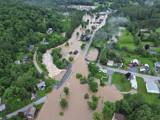
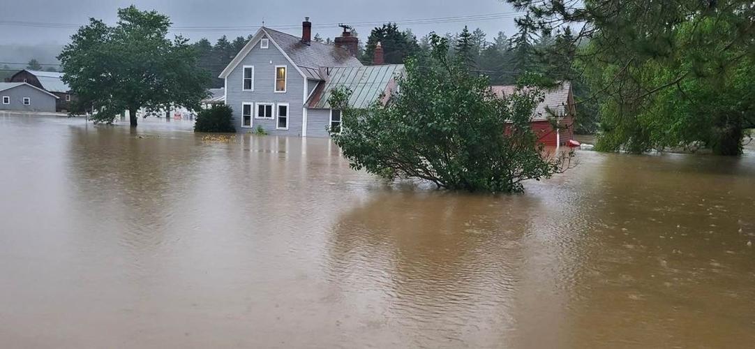
LONDONDERRY — Parts of this town have been evacuated and its highways are impassible due to flooding from a rainstorm Sunday night and Monday morning.
Dramatic photos showed portions of the mountain town along the West River was under water, with more rain expected through Tuesday.
A photo posted to the Northshire Vermont Community Forum showed that North Main Street was fully inundated by water – up to the roof of a car along the state highway.
Flood conditions were also reported in Weston.
Town Clerk and state Rep. Kelly Pajala, D-Windham-Windsor-Bennington, said some Londonderry residents have been evacuated from their homes due to flooding, and that the north village (along Route 11) is “under a lot of water.”
“The south village is essentially cut off,” she said. “The bridge on Route 100 in the south village is closed to traffic, there’s flooding on Route 11 between the villages, and there’s flooding north of Londonderry.”
We’re not even able to assess damage at this point - and we still have hours of rain coming,” she said.
Gov. Phil Scott and emergency management officials briefed reporters late Monday morning from the state emergency operations center in Waterbury. Scott declared a state of emergency on Sunday afternoon, expecting that the storm would cause flooding.
Scott was concerned because unlike Tropical Storm Irene, more rain was expected to fall through Tuesday morning.
"It's not just the initial damage it's a second wave, a third wave," Scott said. Scott said he would prioritize life and safety adding "The rest can be replaced."
Highway closures Monday included Route 100 in Londonderry and Weston, and Route 11 from Winhall to Londonderry. Route 30 was closed in Jamaica and Winhall, but was reopened, officials said.
The First Baptist Church in South Londonderry and Flood Brook School have been opened as emergency shelters.
At Flood Brook, Ryan Comar said the school had welcomed handful of folks who were evacuated from their homes or vehicles, and the Londonderry Rescue Squad was staging there as well. There were tables, chairs, power for charging devices, internet access, water and coffee, and food had started to arrive, he said.
"We're open and here if people need it," Comar said.
Pajala herself was forced to leave her apartment with one of her two sons and their cats. But they’re safe, and she’s more concerned that people might be on the roads getting in the way of emergency workers – and putting themselves at risk.
“For anyone who’s safe and dry, stay home stay safe and stay off the road,” she said. "Please don't drive down roads with 'road closed' signs. Please."
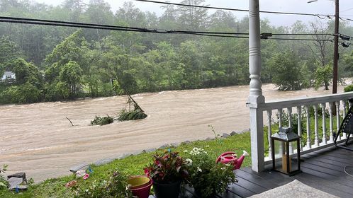
Pajala said she walked out at 3 a.m. to check on the West River. “It was still well within its banks although very full and running fast,” she said. “When my phone rang at 6 a.m., it was already flooding the road. We were barely able to get our car out of our parking space and up to higher ground.”
If people need to be evacuated they should reach out to their local emergency management director, Pajala said.
In Manchester, Town Manager Scott Murphy said the key flood-prone points along the Battenkill River and its tributaries are "high but not breached. We're watching and monitoring carefully."
Murphy said the town's public works director, Jeff Williams, is mainly concerned about flooding coming down off the mountains and affecting low points in town.
Kris "KJ" Johnston, director of IT innovation at Rescue Inc. based in Brattleboro and Townshend, said his group assisted in a water rescue in Londonderry on Monday morning. Rescue also covered the hard-hit Keene, N.H., area from Keene Fire Department on Sunday night.
Johnson said five swift-water boat teams were stationed in Putney and up the West River Valley.
Jamaica Town Administrator Mike Tuller said waters were pretty high in Jamaica during an interview at about 9:30 a.m. Monday.
"They've lost some culverts," he said. "Some driveways have been impacted is what I was told."
Tuller noted "concentrated rain events" are occurring more frequently now.
"It's pretty heavy duty stuff," he said.
Jamaica Select Board Chairwoman Jessica Pollack, who was taking phone calls at Town Office, said Pike Falls Road was closed and Route 30 at the intersection of West Hill Road had been closed briefly then reduced to one lane of traffic, not due to damage but debris coming from a washout down West Hill Road.
"We have some other folks we are watching for instance on Turkey Hill, where there's difficulty potentially getting in and out of their homes," she said.
The primary concern, at the time of the interview at about 9:45 a.m. Monday, had been the continuing rain and the height of Ball Mountain Brook.
"Nothing has breached yet," Pollack said. "It's high and that's scary."
Jamaica Emergency Management Director Paul Fraser and the town road crew are monitoring the situation. Fraser "guided us through Irene," Pollack said in reference to the tropical storm in August 2011.
"We're still in the middle of the event so we're hoping it doesn't get worse but there's a lot more rain forecasted," Pollack said.
Pollack noted the West River is moving fast.
According to USGS data, the West River's height at 11:30 a.m. Monday was at 9.12 feet. At 6:30 p.m. Sunday night, it was measured at 5.7 feet.
This story will be updated.